alternative 2 - clark county washington... changes in land use/zoning, ... county and city zoning ....
TRANSCRIPT

The new planning assumptions, policy direction, changes in land use/zoning, and principles and values defined by the commissioners are reflected in this alternative.
Alternative 2
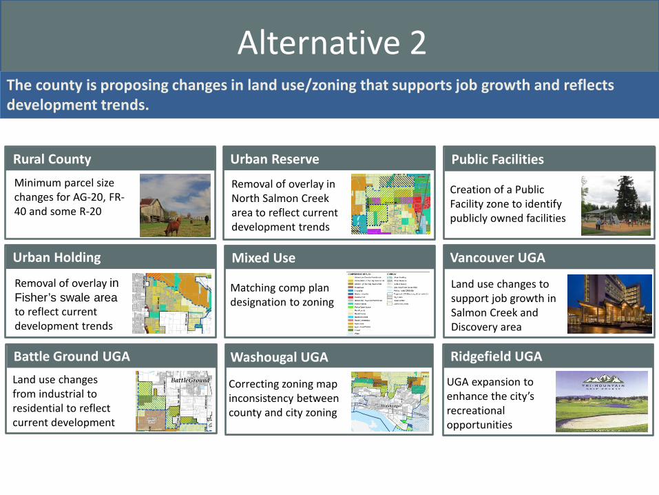
Alternative 2 The county is proposing changes in land use/zoning that supports job growth and reflects development trends.
Rural County Minimum parcel size changes for AG-20, FR-40 and some R-20
Public Facilities
Creation of a Public Facility zone to identify publicly owned facilities
Washougal UGA
Correcting zoning map inconsistency between county and city zoning
Vancouver UGA Vancouver UGA
Land use changes to support job growth in Salmon Creek and Discovery area
Battle Ground UGA Land use changes from industrial to residential to reflect current development
Urban Reserve
Removal of overlay in North Salmon Creek area to reflect current development trends
Mixed Use
Matching comp plan designation to zoning
Ridgefield UGA
UGA expansion to enhance the city’s recreational opportunities
Urban Holding
Removal of overlay in Fisher’s swale area to reflect current development trends

Alternative 2 Comprehensive plan designation changes and zoning updates
1. Consolidation of comprehensive plan land use designations o Rural: Consolidate multiple Rural comp plan designations (R-5, R-10, R-20) to one Rural (R)
designation o Forest: Consolidate two Forest comp plan designations (Forest Tier I and Forest Tier II to one
Forest (F) designation
o Commercial: Consolidate multiple urban commercial comp plan designations (Neighborhood, Community and General) to one Commercial (C) designation
o Urban Reserve: Combine Urban Reserve (UR) comp plan designation and overlays into one urban reserve overlay. Implemented on the zoning map by UR-10 overlay on residential and UR-20 overlay on all other zones.
o Urban Holding: Create an Urban Holding overlay (UH) comp plan designation. Implemented on the zoning map by UH-10 for residential and UH-20 on all other zones.
2. Surface Mining Overlay (SMO) o Implement the SMO comp plan and zoning overlay based on BOCC direction from June 3, 2014
hearing 3. Removal of Three Creeks Special Planning Area overlay
o Work will be completed with 2016 Comprehensive Growth Management Plan update

Alternative 2 RURAL AREAS Recommendations from the Rural Lands Task Force
• Reduce minimum lot area requirements – Agriculture zoning: from
20 acres to 10 acres – Forest zoning: For parcels
zoned FR-40, from 40 acres to 20 acres
– Rural zoning: For parcels zoned R-20, from 20 acres to 10 acres, in some areas

Alternative 2
BATTLE GROUND UGA Change from industrial land to low density residential and change the R1-5 of adjacent parcels to R1-20 to recognize existing uses.
Comp plan map: Change from Industrial (I) to Urban Low Residential (UL)
Six parcels abutting NE 189th St to change from Single-family residential R1-5 (5,000 sq. ft. lots) to Single-family residential R1-20 (20,000 sq. ft. lots) with Urban Holding (UH-10) overlay
Zoning map
Change from Business Park (BP)and Urban Holding (UH-20) to Single-family residential R1-20 (20,000 sq. ft. lots) with Urban Holding (UH-10) overlay
Alternative 2 – County initiated changes
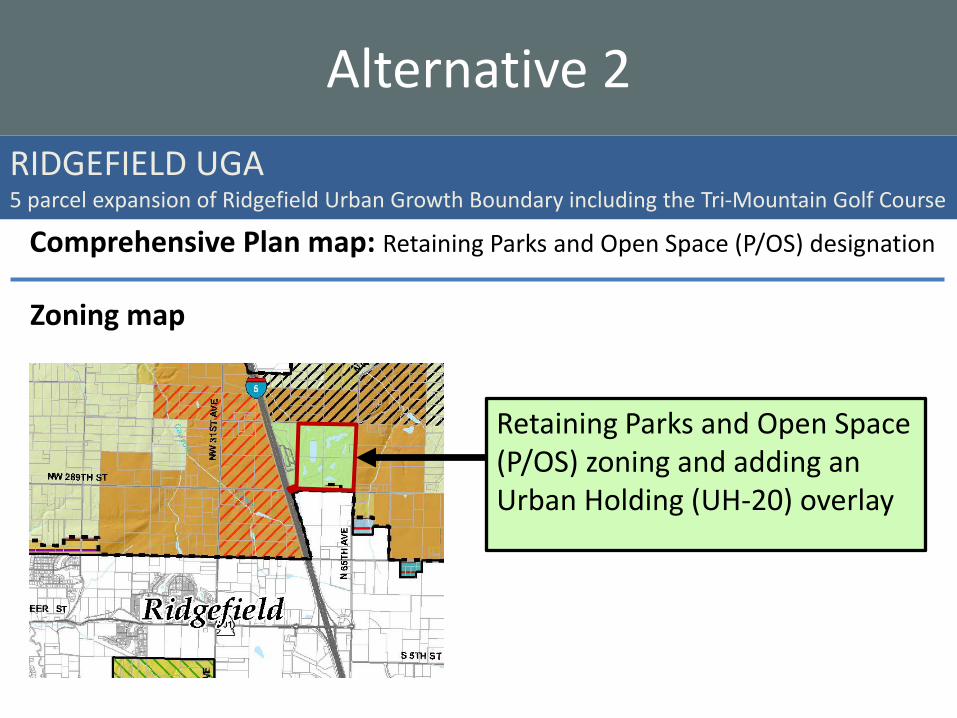
RIDGEFIELD UGA 5 parcel expansion of Ridgefield Urban Growth Boundary including the Tri-Mountain Golf Course
Alternative 2
Comprehensive Plan map: Retaining Parks and Open Space (P/OS) designation
Zoning map
Retaining Parks and Open Space (P/OS) zoning and adding an Urban Holding (UH-20) overlay
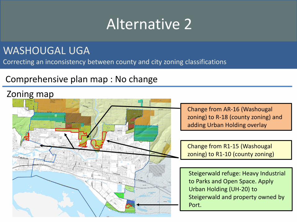
Alternative 2 WASHOUGAL UGA Correcting an inconsistency between county and city zoning classifications
Comprehensive plan map : No change Zoning map
Steigerwald refuge: Heavy Industrial to Parks and Open Space. Apply Urban Holding (UH-20) to Steigerwald and property owned by Port.
Change from R1-15 (Washougal zoning) to R1-10 (county zoning)
Change from AR-16 (Washougal zoning) to R-18 (county zoning) and adding Urban Holding overlay

Alternative 2 – County initiated changes VANCOUVER UGA Both the Discovery - Fairgrounds and Salmon Creek sub-area plan recommendations were developed by advisory groups composed of stakeholders from the specific area including property owners and leaders of major institutions.
Zoning map (current) Zoning map (proposed)
Alternative 2
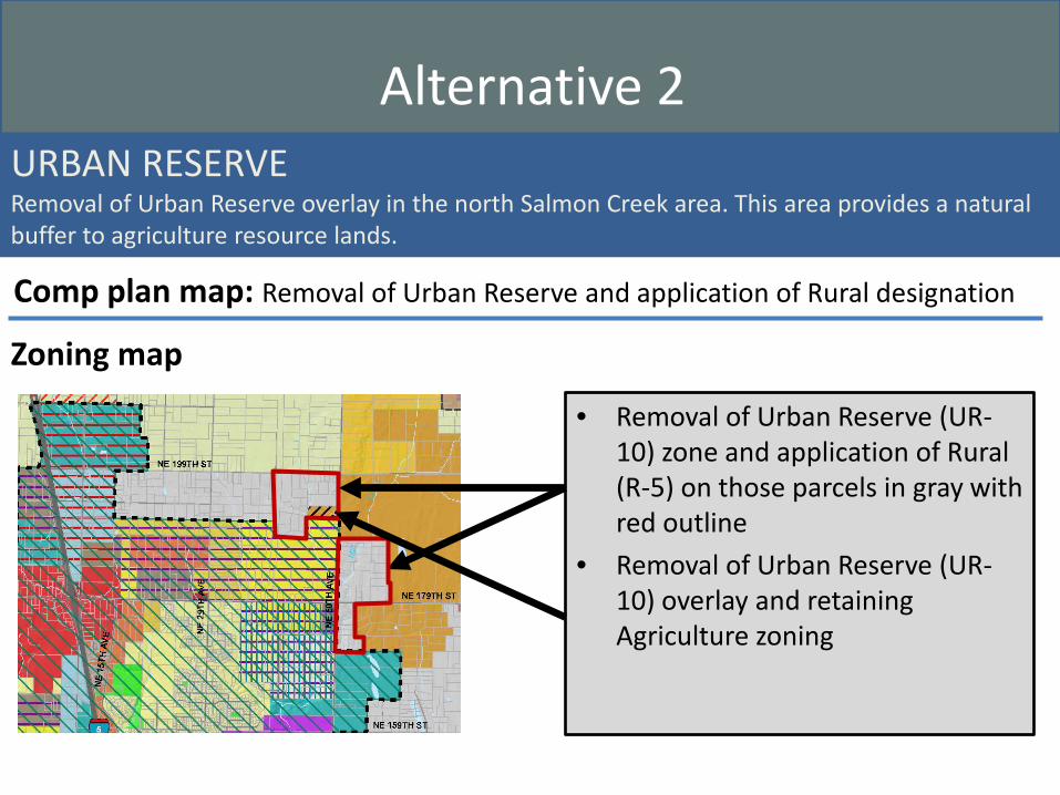
URBAN RESERVE Removal of Urban Reserve overlay in the north Salmon Creek area. This area provides a natural buffer to agriculture resource lands.
• Removal of Urban Reserve (UR-10) zone and application of Rural (R-5) on those parcels in gray with red outline
• Removal of Urban Reserve (UR-10) overlay and retaining Agriculture zoning
Comp plan map: Removal of Urban Reserve and application of Rural designation
Zoning map
Alternative 2

URBAN HOLDING Removal of Urban Holding designation in the Fisher’s Swale area within the Vancouver Urban Growth Boundary – these areas are already developed and are served by infrastructure
Comprehensive plan map: Retaining Urban Low Residential designation
Zoning map
Removal of Urban Holding-10 (purple stripes) and keep the Single-Family Residential zoning of (R1-20), (R1-10) and (R1-7.5)
Alternative 2

MIXED USE Application of appropriate comprehensive plan designation to match the actual zone in use instead of the mixed use
Proposed comprehensive plan map
Change from Mixed Use (MU) comp. plan designation to match the zoning • Includes parcels outlined in yellow • New comp. plan designations include:
– Commercial – Industrial – Urban Low Residential – Urban Medium Residential – Urban High Residential
Zoning map: Retaining current zoning
Alternative 2

Comprehensive plan map • The comprehensive plan
map applies a Public Facilities (PF) designation to land owned by some public entities.
Zoning map • Changing to Public Facilities
(PF) zone
PUBLIC FACILITIES Creation of a Public Facilities comprehensive plan designation and zoning district. The district includes publicly owned facilities, i.e. schools, utilities and government buildings
Alternative 2