allerdale borough council 2010 sfra update · 2018-05-03 · 2010s4396_abc_sfra_vol1_final.docx iii...
TRANSCRIPT

Allerdale Borough Council 2010 SFRA Update
Volume 1
Final Report January 2011 Allerdale Borough Council Allerdale House Workington Cumbria CA14 3YJ
Allerdale Borough Council 2010 SFRA Update

JBA Office JBA Consulting The Brew House Wilderspool Park Greenhall's Avenue WARRINGTON WA4 6HL
JBA Project Manager Chris Smith
Revision History
Revision Ref / Date Issued Amendments Issued to
Draft report. Version 1.0 Allerdale BC and EA
Final report. Version 2.0 Updated following EA and ABC reviews
Allerdale BC and EA
Contract This report describes work commissioned by Steve Robinson, on behalf of Allerdale Borough Council, by an email dated 26/08/10. Allerdale Borough Council’s representative for the contract was Steve Robinson. Sam Wingfield and Chris Smith of JBA Consulting carried out this work.
Prepared by .................................................. Samuel Wingfield BSc MRes
Analyst
Reviewed by ................................................. Chris Isherwood BSc MSc DipWEM
Analyst
Purpose This document has been prepared as a final report for Allerdale Borough. JBA Consulting accepts no responsibility or liability for any use that is made of this document other than by the Client for the purposes for which it was originally commissioned and prepared.
JBA Consulting has no liability regarding the use of this report except to Allerdale Borough Council.

2010s4396_ABC_SFRA_Vol1_final.docx ii
Copyright
© Jeremy Benn Associates Limited 2011
Carbon Footprint
336g
A printed copy of this document will result in a carbon footprint of 264g if 100% post-consumer recycled paper is used and 336g if primary-source paper is used. These figures assume the report is printed in black and white on A4 paper and in duplex.
JBA is a carbon neutral company and the carbon emissions from our activities are offset.

2010s4396_ABC_SFRA_Vol1_final.docx iii
Executive Summary
Development & Flood Risk
Local Planning Authorities (LPAs) have a raft of issues to consider when planning future development. These are dictated by Government Planning Policy Statements.
Planning Policy Statement 25 (PPS25) relates to development and the constraint of flood risk, with its overarching aim of avoiding development in flood risk areas. This is achieved through PPS25 by the sequential approach to land allocation, meaning that development should be firstly avoided in flood risk areas wherever possible before considering the vulnerability of development planned or possible mitigation measures. The sequential approach is governed by two tests; the Sequential and Exceptions Test. The consideration of flood risk to people and development must be considered by the LPA at the earliest stage of spatial planning decisions and these tests allows this process to be transparent and affective.
In order to carry out these tests a coherent understanding of flood risk is needed at a local level. High level policy and guidance documents such as Catchment Flood Management Plans (CFMPs), Shoreline Management Plans (SMPs) and Regional Flood Risk Appraisals (RFRA) have provided a good introduction in to flood risk; however they do not provide the level of detail required for the LPA to make the right spatial planning decisions.
Strategic Flood Risk Assessments (SFRAs) offer this local level of understanding. SFRAs provide the LPA with a central source of all relevant flood risk information and the evidence base to make tough planning decisions and develop focused local policies required to inform the Local Development Framework (LDF). The SFRA therefore becomes a key planning tool that enables the LPA to select and develop sustainable site allocations.
A SFRA offers the foundation of this evidence base. It is based purely on the collation of existing flood risk information. The Environment Agency Flood Map is the main source of fluvial and tidal flood information across England and Wales and is the basis of PPS25 Flood Zones used in the Sequential and Exception Tests. The Level 1 SFRA must also consider flooding from all other sources (surface water, sewers, groundwater and artificial sources). This is only achievable through consulting with those stakeholders with specific interest or knowledge in other sources of flooding.
The Level 1 SFRA is assisted greatly by the use of Strategic Flood Risk Maps providing information on flood risk factors needed to be taken into account. The PPS25 Flood Zone Map enables the LPA to carry out the first sweep of Sequential Testing. The additional maps produced as part of the Level 1 SFRA should be used during the Sequential Test ‘sieving’ process further identify inappropriate development.
Once the LPA has carried out the Sequential Test sieving process, they still may wish to allocate vulnerable development in high-risk areas due to the wider need for economic growth and regeneration. In this case the allocations must pass the Exception Test. The evidence provided in the Level 1 SFRA is not detailed enough to justify development through the Exception Test. In order to achieve this Level 2 SFRA must be carried out.
A Level 2 SFRA provides the LPA with a detailed understanding of flood hazard, assessing flood depth, velocity and residual risks such as flood defence breaching or overtopping. If required, the information provided in a Level 2 SFRA will give the LPA a much more detailed understanding of flood risk at potential development sites. Although it will not provide all the information needed to apply the Exception Test, it will include the appropriateness of the development and the likelihood of it remaining safe if flooded. If the LPA has justified the development by passing parts a) and b) of the Exception Test, it must be supported by a site specific Flood Risk Assessment (FRA) in order to pass part c).
This report (Volume 1) describes the SFRA process and also covers guidance on how to use the SFRA.

2010s4396_ABC_SFRA_Vol1_final.docx iv
Understanding the SFRA Process
Volume 1 of the Allerdale SFRA introduces the SFRA process. It is an excellent reference document for current flood risk management drivers, national regional and local planning policy and Environment Agency policy such as the CFMPs and SMPs.
The report also provides a brief understanding of the mechanisms of flooding and flood risk for those new to the subject. More importantly, it provides a comprehensive discussion on PPS25, the Sequential, Exception Test and links regional and local flood risk assessments.
Volume 1 also holds the methodology data management section of the study.
SFRA Guidance for Spatial & Development Management
Volume 1 of the Allerdale SFRA also provides guidance and recommendations to spatial planners, planners, developers and emergency planners, how to use the flood risk information provided in Volume 2.
This Volume should be read by:
� Spatial Planners � Development Control � Planners � Developers � Emergency Planners � Key Stakeholders including the Environment Agency and Northumbrian Water

Contents
2010s4396_ABC_SFRA_Vol1_final.docx
Executive Summary ........................................................................................................ iii�
1� Introduction ........................................................................................................ 1�
1.1� Background .......................................................................................................... 1�1.2� Scope & Objectives ............................................................................................. 1�
2� The Planning Framework .................................................................................. 3�
2.1� Introduction .......................................................................................................... 3�2.2� Flood Risk Management Drivers ......................................................................... 3�2.3� National Planning Policy ...................................................................................... 8�2.4� Regional Policy Drivers ........................................................................................ 10�2.5� Environment Agency Policy ................................................................................. 13�2.6� Coastal Policy ...................................................................................................... 16�2.7� Flood Risk Policy ................................................................................................. 18�2.8� Summary ............................................................................................................. 24�
3� Methodology and Data Sources ....................................................................... 25�
3.1� Methodology of Strategic Flood Risk Assessment .............................................. 25�3.2� Approach to the SFRA ......................................................................................... 27�3.3� Flood Defences .................................................................................................... 29�3.4� Topography .......................................................................................................... 30�3.5� Hydraulic Modelling ............................................................................................. 30�3.6� Historical Flooding ............................................................................................... 31�3.7� Identification of Critical Drainage Areas .............................................................. 31�3.8� Limitations of Background Information ................................................................ 32�
4� The Sequential Approach ................................................................................. 33�
4.1� Introduction .......................................................................................................... 33�4.2� The Sequential Test ............................................................................................. 33�4.3� The Exception Test .............................................................................................. 33�4.4� Flood Risk Vulnerability Classification ................................................................. 36�4.5� Levels of Flood Risk Assessment ........................................................................ 38�4.6� Level 1 Strategic Flood Risk Assessment ........................................................... 39�4.7� Applying flood risk to the LDD ............................................................................. 40�4.8� Applying the Sequential Test and assessing the likelihood of passing the
Exception Test ..................................................................................................... 41�
5� Strategic Flood Risk Guidance ........................................................................ 47�
5.1� Guidance for Planners & Developers .................................................................. 47�5.2� Guidance for Flood Risk Assessments ................................................................ 54�
Appendices...................................................................................................................... 58�
A .� Flood Risk Zones ............................................................................................... 58�
B .� Flood Risk Classification .................................................................................. 60�
C .� Development in the Flood Zones ..................................................................... 62�

2010s4396_ABC_SFRA_Vol1_final.docx
List of Figures Figure 1 – CFMP Policy Units and Options .................................................................. 14�
Figure 2 – Flood Zones and flood defences in Cockermouth .................................... 22�
Figure 3 – The Location of Allerdale BC Area and the Main Rivers .......................... 26�
Figure 4 - Where the Exception Test Applies .............................................................. 34�
Figure 5 - Taking flood risk into account in LDDs ...................................................... 41�
Figure 6 - Sequential and Exception Test Flow Diagram ........................................... 43�
Figure 7 - Sequential and Exception tests Key Steps ................................................. 44�
Figure 8 - 1st and 2nd Pass of Proposed Development Sites Sequential Test ........ 45�
Figure 9 - Identifying the Likelihood of passing the Exception Test ........................ 46�
Figure 10 - Illustration of the undefended scenario under fluvial and/or tidal flood risk ............................................................................................................. 48�
Figure 11 - Illustration of the defended scenario and residual flood risk behind fluvial/tidal defences ......................................................................................... 49�
List of Tables Table 1 – NFCDD Condition Ratings ............................................................................. 30�
Table 2 - Summary of Hydraulic Models Available within the SFRA Area ................ 30�
Table 3 – Suggested screening criteria for mitigation measures .............................. 36�
Table 4 - Flood Hazard Thresholds ............................................................................... 52�

2010s4396_ABC_SFRA_Vol1_final.docx
Abbreviations ABD Areas Benefiting from Defences AEP Annual Exceedance Probability CFMP Catchment Flood Management Plans CLG Communities and Local Government COW Critical Ordinary Watercourse CS Core Strategy DPDs Development Plan Documents EA Environment Agency EU European Union FAS Flood Alleviation Schemes FEH Flood Estimation Handbook FCERM Flood and Coastal Erosion Risk Management FRA Flood Risk Assessment FRM Flood Risk Management IDB Internal Drainage Board IDD Internal Drainage District IFM Indicative Floodplain Map LDDs Local Development Documents LDF Local Development Framework LPAs Local Planning Authorities NFCDD National Fluvial and Coastal Defence Database NPD National Property Dataset NWL Northumbrian Water Ltd PPG Planning Policy Guidance PPS Planning Policy Statement RBD River Basin District RBMP River Basin Management Plan RFRA Regional Flood Risk Assessment RPB Regional Planning Bodies RPG Regional Planning Guidance RSS Regional Spatial Strategy RVFD Receptors Vulnerable to Flooding Database SA Sustainability Appraisal SEA Strategic Environmental Assessment SFRA Strategic Flood Risk Assessment SMP Shoreline Management Plans SoP Standard of Protection SPD Supplementary Planning Document SuDS Sustainable (Urban) Drainage Systems SWMP Surface Water Management Plan UDP Unitary Development Plan WCS Water Cycle Study

2010s4396_ABC_SFRA_Vol1_final.docx 1
1 Introduction
1.1 Background
In March 2006 JBA Consulting was commissioned by Allerdale Borough Council (BC) to undertake a Strategic Flood Risk Assessment (SFRA) for the Allerdale area, excluding the Lake District National Park. The purpose of this assessment was to identify the strategic flood risk constraints to the area. JBA were commissioned to update the SFRA in August 2010 following recent flooding events in Allerdale and the recent developments in flood risk management policy since 2007.
For this update, the SFRA has been broken down in to two volumes. Volume 1 covers the more general information that requires updating. This includes SFRA and planning policy, (including completion of the Sequential and Exception Tests), guidance on how to use the SFRA and the methodology. The original text from 2007 SFRA has been updated to reflect policy and guidance changes.
1.2 Scope & Objectives
Flooding is a natural process and does not respect political demarcations or administrative boundaries; it is influenced principally by natural elements of rainfall, tides, geology, topography, rivers and streams and man made interventions such as flood defences, roads, buildings, sewers and other infrastructure. As was seen in the November 2009 floods, flooding can cause massive disruption to communities, damage to property and possessions and even loss of life.
For this reason it is very important to try and avoid developing in flood risk areas in the first instance. Where this is not possible the vulnerability of the proposed land use to flooding should be considered and measures taken to minimise flood risk to people, property and the environment. This is the thrust of the risk based sequential approach to managing flood risk and it is the backbone of PPS25.
Current Government policy requires local authorities to demonstrate that due regard has been given to the issue of flood risk as part of the planning process. It also requires that flood risk is managed in an effective and sustainable manner and where new development is exceptionally necessary in flood risk areas, the policy aim is to make it safe without increasing flood risk elsewhere, where possible flood risks should be reduced overall.
A SFRA therefore becomes a planning tool that enables the Council to select and develop sustainable site allocations away from vulnerable flood risk areas. The assessment focuses on the existing site allocations within the borough but also sets out the procedure to be followed when assessing additional sites for development in the future.
It is recognised that land use pressures for re-generation, inward investment and economic growth exist across Allerdale BC and this SFRA will guide the Council in their strategies, policies and decision making in respect of their Local Development Framework (LDF) and Local Development Documents (LDDs).
The key objectives of this SFRA are to:
� Investigate and identify the extent and severity of flood risk to the area at present and in the future, under the terms of PPS25;
� Contribute to the Council’s Strategic Environmental Assessment (SEA) and LDF ; � Enable the Council to apply the Sequential Test and the Exception Test; � Provide strategic flood risk guidance and advice to planners and developers; � Identify specific locations where further and more detailed flood risk data and
assessment work is required. This includes Level 2 SFRAs and the scope for Surface Water Management Plans and/or Water Cycle Studies;
� Identify the level of detail required for site-specific FRAs;

2010s4396_ABC_SFRA_Vol1_final.docx 2
� Inform the emergency planning process; � Improve stakeholder joint working and the sharing of data, information and the
understanding of flood risk; and � Be used as a reference document.
There is a recent trend developing since the publication of the PPS25 Practice Guide in 2008 that SFRAs are more than a land use planning tool, and can provide a much broader and inclusive vehicle for integrated, strategic and local Flood Risk Management (FRM) assessment and delivery. Since publication of the Pitt Review, it is apparent that SFRAs will provide the central holder for data, information and consideration for all flood risk issues relating to flooding from all sources at a local level; and provide the linkage between CFMPs, SMPs, RFRAs, SWMPs and appropriate sustainable land uses over a number of planning cycles. SFRAs are proving a pivotal vehicle in the introduction and promotion of a local authority, post Pitt Review, role in local flood management. Volume 2 of this update will cover these changes.
SFRAs need to be fit for the future to help communities meet the considerable FRM and climate change related challenges that lay ahead.

2010s4396_ABC_SFRA_Vol1_final.docx 3
2 The Planning Framework
2.1 Introduction
The purpose of this section of the report is to identify and outline those high level documents which have been taken into account in preparing this SFRA, from a national to local level.
The land use planning process is driven by a whole host of policy guidance on a national, regional and local level. Whilst the majority of these policies are not aimed at mitigating flood risk, there are key links at strategic, tactical and operational levels between land use and spatial planning (Local Government), and Flood Risk Management (FRM) planning (Environment Agency), which should be considered as part of a planned and integrated approach to delivering sustainable development.
The sustainability appraisal will help draw together these links and balance the application of wider social, economic and environmental planning policy and guidance. Flood risk assessment is required at all levels of the planning process and for all major developments in flood risk areas; these play and increasingly important role in assisting effective delivery of key planning objectives.
The end of this chapter provides some recommendations for specific flood risk policies in areas at high risk of flooding in Allerdale BC.
2.2 Flood Risk Management Drivers
The principal FRM policy drivers are brought together in the Government’s recently released Flood and Water Management Act1 and it is an important part of the Government’s response to Sir Michael Pitt’s Report on the summer 2007 floods2. It also gives effect to a number of commitments in the Government’s “Future Water” strategy document. In addition, the Act responds to a number of climate change challenges including, more frequent extreme weather events causing a greater risk of flooding and drought, increased population, increased water demand and more water quality problems. It provides the Environment Agency with a strategic overview role for flood risk in England and Wales and gives local authorities in England a clear leadership role in local flood risk management encompassing all sources of flooding. An improved integrated and risk based approach is proposed to the future management of flood risks, and this requires other concerns such as sustainability, biodiversity and the whole water cycle to be taken into account by local authorities and other relevant organisations.
A core policy thread running through all current policy drivers is the fundamental shift in emphasis from building defences to prevent flooding, to one of managing flood risk by using a suite of measures. All operating authorities are required to invest in the provision of sustainable flood risk management and this includes LPAs adopting a flood risk management hierarchy of assessing, avoiding, substituting, controlling and mitigating flood risk through the land use planning system. They should have regard to flooding from all sources (particularly surface water and not just from rivers and the sea). Government does however; recognise that in some circumstances, appropriate mitigation measures may still involve new, or improving and maintaining existing flood defences where justified, to protect increasingly vulnerable communities.
Current key policy related documents provide LPAs with important and valuable knowledge on the strategic direction of flood risk management and assist their strategic land use planning decision making for re-generation, inward investment and growth etc. Key documents currently influencing FRM policy are:
� EU Floods Directive – (2007)3
1 HM Government (2010) Flood and Water Management Act 2 Sir Michael Pitt (2008) The Pitt Review - Learning Lessons from the 2007 floods 3 HM Government (2009) Flood Risk Regulations © Crown copyright

2010s4396_ABC_SFRA_Vol1_final.docx 4
� Flood and Water Management Act – Defra (2010) � Future Water (2008) � Improving Surface Water Drainage – Defra (2008) � Making Space for Water – Defra (2005) � Planning Policy 25: Development & Flood Risk - (2010) � Planning Policy 25: Development & Flood Risk Practice Guide - (2009) � Learning Lessons from the 2007 Floods – Sir Michael Pitt (2008) � Catchment Flood Management Plans � Shoreline Management Plans
2.2.1 EU Floods Directive
The “EU Floods Directive” aims to reduce and manage the risk floods pose to human health, the environment, cultural heritage and economic activity. Member States have two years in which to transpose its provisions into domestic legislation and the first requirements of the Directive begin at the end of 2011. By this date, an evidence base for flood risk should be developed to map the risk and then produce plans to manage it. Preliminary Flood Risk Assessments (PFRAs) for all sources of flooding need to be prepared showing the impact of historic flooding and the potential impact of a repeat event. Following this, areas of potentially Significant Flood Risk (SFR) need to be defined. In addition, and by the end of 2013, flood hazard and flood risk maps for the SFR areas are required and be co-ordinated with, and possibly integrated into, the reviews of River Basin Districts under the Water Framework Directive (WFD). Finally, by the end of 2015, Flood Risk Management Plans (FRMPs) must be established to aim to reduce the potential adverse consequences of flooding and/or reduce its likelihood.
� Dec 2011 Preliminary Flood Risk Assessment (PFRA) � Review by Dec 2017 then 6 yearly intervals
� Dec 2013 Mapping Elements � Review by Dec 2019 then 6 yearly intervals
� Dec 2015 Surface Water Management Plans (SWMP) � Review by Dec 2021 then 6 yearly intervals
The Government propose to use existing flood risk planning outputs of RFRAs and SFRAs to deliver the requirements of PFRAs. It is also proposed that local authorities extend their Level 2 SFRAs to look at the impact of flooding on the environment and cultural heritage when determining SFR areas. In addition, it is proposed that SWMPs will be FRMPs under the Directive, and will be a tool more generally for local flood risk management. This integrated approach will underpin the planning system and guide the location of future development to avoid and minimise flood risk, whilst also meeting the requirements of the Floods Directive. Local authorities, through their land use planning activities, have a key role to play.
2.2.2 Flood & Water Management Act
The Flood and Water Management Act proposes new unifying legislation covering all forms of flooding and shifting the emphasis from building defences to managing risk. It aims to:
� Reduce the likelihood and impacts of flooding; � Improve the ability to manage the risk of flooding, by clarifying who is responsible
for what; � Reduce pollution and improve water quality; � Give water companies better powers to conserve water during drought; � Reduce red tape and other burdens on water and sewerage companies; and

2010s4396_ABC_SFRA_Vol1_final.docx 5
� Improve the overall efficiency of the industry. A number of proposals in the Act have particular implications for local authorities, land use planning and related flood risk. These include:
� The Environment Agency will be given a strategic overview role covering all forms of flooding and will coordinate maps and plans in relation to the sea, main rivers and reservoirs; it will also be given the same powers as Councils to carryout coastal erosion works and may be a statutory consultee in respect of future coastal erosion planning applications;
� Local authorities will have an enhanced leadership role in local flood risk management which includes ensuring that flood risk from all sources, including from surface run-off, groundwater and ordinary watercourses, is identified, taken account of in the spatial planning process and managed as part of locally agreed work programmes;
� Local authorities will develop a suite of measures for managing local flood risk, for example, surface water mapping, appropriate development planning and collating information on flood risk and drainage assets;
� County and unitary authorities will be responsible for local flood risk assessment and lead in ensuring the production of SFRAs and SWMPs;
� SFRAs will provide the evidence to allow LPAs to factor flood risk into their LDFs, DPDs and individual planning proposals, and help to determine where SWMPs are needed;
� Level 2 SFRAs in areas of significant risk would directly inform EU Floods Directive flood risk maps and also inform the production of local FRMPs, such as SWMPs;
� SWMPs will have a stronger role in coordinating development and investment planning;
� County and unitary authorities will lead new local partnerships and have responsibility for adopting and maintaining sustainable drainage systems (SUDS) in new development, where they affect more than one property;
� The automatic right to connect surface water drains and sewers to the public sewerage system will be ended and developers will be required to put SuDS in place in new developments wherever practicable;
� Surface water connection to public sewers will be conditional on meeting new national standards on SUDS and drainage, and the approval of a SUDS approving body will be needed, and a certificate issued, before development can begin;
� Increased emphasis is needed on enabling flood water to safely flow overland with green infrastructure and safe flow routes being identified as part of flood risk assessments;
� County or unitary authorities, the Environment Agency and IDBs will have powers to formally designate natural and man-made features (similar in principle to the Listed Buildings classification), which help to manage flood or coastal risk; they will give formal consent before anyone can change or remove the feature and use enforcement powers where needed; and
� All relevant authorities will have a duty to cooperate and share information. The content and implications of the Act provide considerable opportunities for improved and integrated land use planning and flood risk management by local authorities and other key partners. The integration and synergy of strategies and plans at national, regional and local scales, is increasingly important to protect vulnerable communities and deliver sustainable re-generation and growth.
Key dates for implementing the Flood and Water Management Act include:
1. June 2011 Preliminary Flood Risk Assessment (PFRA) 2. June 2013 Mapping Flood Risk & Hazards 3. June 2015 Flood Risk Management Plans

2010s4396_ABC_SFRA_Vol1_final.docx 6
2.2.3 Improving Surface Water Drainage
The “Improving Surface Water Drainage” consultation document was produced in support of the Government’s water strategy and in line with Sir Michael Pitt’s initial conclusions. Many of the proposals identified have been carried forward into the Flood and Water Management Act. The consultation considers policy measures to improve the way surface water runoff is managed. In particular, it proposes:
1. Issuing SWMPs as a tool to improve co-ordination between stakeholders involved in drainage and local management of flood risk;
2. Increasing uptake of SUDS by clarifying responsibilities for adoption and management; and
3. Reviewing the ability for premises to connect surface water drainage automatically into the public sewer system.
Current roles and responsibilities were considered along with various options for improving the current surface water drainage situation. In particular, the document recognises that SFRAs and SWMPs already form part of the PPS25 planning framework and there is an aim to enhance their role and make stronger links between surface water drainage and strategic planning.
2.2.4 Making Space for Water Strategy
The “Making Space for Water Strategy” is a milestone document that confirms the Government’s strategic direction for Flood and Coastal Erosion Risk Management (FCERM). Over the 20-year lifetime of the new strategy, Government will implement a more holistic approach to managing flood and coastal erosion risks in England. The approach will involve taking account of all sources of flooding, embedding flood and coastal risk management across a range of Government policies and reflecting other relevant Government policies in the policies and operations of operating authorities for flood and coastal erosion risk management.
The 2004 consultation document “Making Space for Water” sets out the following vision:
“…we want to make space for water so that we can manage the adverse human and economic consequences of flooding and coastal erosion while achieving environmental and social benefits in line with wider government objectives.”
In other words, the aim of the strategy is to balance the three pillars of sustainability, managing flood risk and ensuring that the social and economic benefits which accrue from growth and development are attained. This balanced approach, integrating sustainable development with responsible risk management, has underpinned this SFRA.
Section 7 of the consultation document deals with measures to reduce flood risk through land-use planning, which emphasises the Government’s commitment to ensuring that the planning system aims to reduce flood risk wherever possible and, in any event, should not add to it. However, it is acknowledged that 10% of England is already within mapped areas of flood risk and that contained within these areas are some of the Brownfield sites which other areas of Government policy has identified as a priority for future housing provision. The document asserts that over the past five years, 11% of new houses were built in flood-risk areas. The document identifies three sets of measures, which may be undertaken to manage flood risk when development is sited in such areas:
� Protection measures to provide, at minimum, the standards of protection specified in PPS25;
� Provision of features such as sacrificial areas and compartmentalisation to reduce the consequences of a flood event should one occur (such as functional floodplain); and
� Use of construction techniques that increase the flood resistance and resilience of buildings.
The document proposes that RSSs and LDFs should take full account of flood risk and incorporate the sequential approach in PPS25. Moreover, the document encourages

2010s4396_ABC_SFRA_Vol1_final.docx 7
integration with other planning systems, in particular Catchment Flood Management Plans. Use of European Union (EU) funding streams, such as Intgerreg IIIB is recommended where applicable, to enable Local Authorities to undertake trans-national projects aimed at advancing knowledge and good practice in flood risk management.
2.2.5 Making Space for Water: Programme of Work
The “Making Space for Water: Programme of Work” was developed following consultation and takes account of any relevant recommendations that emerged from the Pitt Review into the 2007 floods that affected many parts of England.
One of Defra’s and CLG’s early outputs from the Making Space for Water Programme was the publication, of PPS25 in December 2006. This work, together with the Practice Guide forms the Governments required approach to managing and reducing flood risk through the land use planning system.
A valuable piece of work looking at “Developing a Broader Portfolio of Options to Deliver Flooding and Coastal Solutions” has been carried out as part of this programme and is very useful to local authorities and other operating authorities, in their strategic planning of flood risk management. Outputs from this work are available from Defra.
Quarterly update reports are released providing details of progress made and key achievements. These reports can be access via the Making Space for Water website at http://www.defra.gov.uk/environ/fcd/policy/strategy.htm
2.2.6 The Pitt Review
The “Pitt Review” has been carried out following the severe floods of summer 2007 and is a key document for local authorities in their consideration of flood risk management. Sir Michael Pitt was asked by Ministers to conduct an independent review of events and report on the lessons that should be learned. In December 2007, an Interim Report was published by the Review team. The Review collected evidence by visiting affected areas and examining over 600 written statements submitted by victims of the floods. The report presents a schedule of interim conclusions, many of which relate to local authorities. These interim conclusions shaped the National approach to flood management and can be accessed via the Defra website.
Pitt’s final report was released in June 2008 and contains detailed findings, conclusions and 92 recommendations for action, covering all aspects of strategic and local flood risk management. These interim conclusions are intended to shape the National approach to flood management and can be accessed via the Defra website. Some of the recommendations which are relevant to this SFRA and the role of local authorities’ in future local flood risk management include;
� Recommendation 11 – Building Regulations should be revised to ensure that all new or refurbished development in high flood risk areas are flood resistant or resilient.
� Recommendation 14 – Local Authorities should lead on the management of local flood risk, with support of the relevant organisations.
� Recommendation 15 – Local Authorities should positively tackle local problems of flooding working with all relevant parties, establishing ownership and legal responsibility.
� Recommendation 16 – Local Authorities should collate and map the main flood risk management and drainage assets (over and underground), including a record of their ownership and condition.
� Recommendation 17 – All relevant organisations should have a duty to share information and cooperate with local authorities and the Environment Agency to facilitate the management of flood risk.
� Recommendation 18 – Local Surface Water Management Plans, as set out under PPS25 and coordinated by local authorities, should provide the basis for managing all local flood risk.

2010s4396_ABC_SFRA_Vol1_final.docx 8
� Recommendation 19 – Local Authorities should assess and, if appropriate, enhance their technical capabilities to deliver a wide range of responsibilities in relation to local flood risk management.
� Recommendation 20 – The Government should resolve the issue of which organisations should be responsible for the ownership and maintenance of sustainable drainage systems.
� Recommendation 52 – In the short term, the Government and infrastructure operators should work together to build a level of resilience in critical infrastructure assets that ensures continuity during worst case flood event.
� Recommendation 57 – The Government should provide Local Resilience Forums with the inundation maps for both large and small reservoirs to enable them to assess risks and plan for contingency, warning and evacuation.
Pitt’s findings, conclusions and recommendations for action are challenging but will be extremely important in guiding local authorities and other operating authorities in their consideration of future flood risk management activities, including land use planning. They have also been a key driver in shaping the content of the Flood and Water Management Act.
2.3 National Planning Policy
This SFRA has been prepared in a period during which planning authorities have been implementing the provisions of the Planning and Compulsory Purchase Act 2004 and accompanying planning guidance, including PPS1 Delivering Sustainable Development and PPS12 Local Development Frameworks. This affected all tiers of the planning system and has necessitated major changes at both the regional and local level which will impact on the way in which planned development is approached in the regional strategy and delivered locally.
2.3.1 PPS25 Development and Flood Risk
In December 2006, the Government published PPS25: Development and Flood Risk.
The aim of PPS25 is to ensure that flood risk is taken into account at all stages in the planning process to avoid inappropriate development in areas at risk of flooding and to direct development away from areas at highest risk. The key planning objectives are that “Regional Planning Bodies (RPBs) and Local Planning Authorities (LPAs) should prepare and implement planning strategies that help to deliver sustainable development by:
� Identifying land at risk and the degree of risk of flooding from river, sea and other sources in their areas;
� Preparing Regional or Strategic Flood Risk Assessments (RFRAs / SFRAs) as appropriate, as a freestanding assessment that contributes to the Sustainability Appraisal of their plans;
� Framing policies for the location of development which avoid flood risk to people and property where possible, and manage any residual risk, taking account of the impacts of climate change;
� Only permitting development in areas of flood risk when there are no suitable alternative sites in areas of lower flood risk and the benefits of the development outweigh the risks from flooding;
2010s4396_ABC_SFRA_Vol1_final.docx 9
� Safeguarding land from development that is required for current and future flood management e.g. conveyance and storage of flood water, and flood defences;
� Reducing flood risk to and from new development through location, layout and design, incorporating sustainable drainage systems (SUDS);
� Using opportunities offered by new development to reduce the cause and impacts of flooding e.g. surface water management plans; making the most of the benefits of green infrastructure for flood storage, conveyance and SUDS; re-creating functional floodplain; and setting back defences;
� Working effectively with the Environment Agency, other operating authorities and other stakeholders to ensure that best use is made of their expertise and information so that plans are effective and decisions on planning applications can be delivered expeditiously; and
� Ensuring spatial planning supports flood risk management policies and plans, River Basin Management Plans and emergency planning.”
In addition to setting out the roles and responsibilities for LPAs and RPBs, PPS25 identifies that landowners also have a primary responsibility for safeguarding their land and other property against natural hazards such as flooding. Those promoting sites for development are also responsible for:
� Demonstrating that is consistent with PPS25 and Local Development Documents (LDDs);
� Providing a Flood Risk Assessment (FRA) demonstrating whether the proposed development: is likely to be affected by current or future flooding; satisfies the LPA that the development is safe; and identifies management and mitigation measures.
PPS25 also introduces an amendment to Article 10 of The Town and Country Planning (General Development Order) 1995 which makes the Environment Agency a Statutory Consultee on all applications for development in flood risk areas, and those within 20m of a Main River.
The Direction also introduces the requirement for LPAs to notify the Secretary of State where they are minded to approve a planning application contrary to a sustained objection by the Environment Agency.
The introduction of PPS25 enables local authorities to make a direction under Article 4 of the Town and County Planning (General Permitted Development) Order 1995. This will enable Local Authorities to remove permitted development rights where those rights threaten to have a direct, significant and adverse effect on a flood risk area, or its flood defences and their access, or the permeability and management of surface water, or flood risk to occupants.
2.3.2 PPS25 Development and Flood Risk Practice Guide
The Practice Guide to PPS25 was published by the Department for Communities and Local Government (CLG) in June 2008. It provides advice on the practical implementation of PPS25 policy and reflects extensive discussion with local authorities, the Environment Agency and other key stakeholders and practitioners. The guide provides further guidance on the preparation of SFRA’s and FRA’s, the Sequential and Exception Test, outlines potential mitigation measures e.g. SUDS and risk management techniques.
Local Authority planners and developers are advised to refer to and use PPS25 and the practice guide in conjunction with the further advice contained within this report.
2.3.3 Other Planning Policy Statements
PPS1 Delivering Sustainable Development published in February 2005 sets out the overarching planning policies for the delivery of sustainable development across the planning system and sets the tone for other planning policy statements. PPS1 explicitly states that development plan policies should take account of flooding, including flood risk. It proposes that new development in areas at risk from flooding should be avoided.

2010s4396_ABC_SFRA_Vol1_final.docx 10
Planning authorities are also advised to ensure that developments are “sustainable, durable and adaptable” including taking into account natural hazards such as flooding.
PPS1 also places an emphasis on ‘spatial planning’ in contrast to the more rigid ‘land use planning’ approach which it supersedes. Planning authorities will still produce site-specific allocations and a proposals map as LDDs, but their Core Strategy will be more strategic and visionary in content and will take into account the desirability of achieving integrated and mixed use development and will consider a broader range of community needs than in the past. With regard to flood risk, it will be important for the Core Strategies and accompanying Supplementary Planning Documents to recognise the contribution that non-structural measures can make to flood management.
Planning Policy Statement: Planning and Climate Change, a supplement to PPS1, published in December 2007, sets out how the Government expects the planning system to address climate change. It explains that there is a compelling scientific consensus that human activity is changing the world’s climate. The evidence that climate change is happening, and that man-made emissions are its main cause, is strong. The Intergovernmental Panel on Climate Change highlights that we are already experiencing the effects of climate change and if these changes deepen and intensify, as they are predicted to do without the right responses locally and globally, we will see even more extreme impacts.
One of the predicted impacts of climate change is more intense periods of rainfall and consequent flooding. The PPS1 supplement requires Regional Spatial Strategies and Local Development Frameworks to shape sustainable communities that are resilient to such effects. A key objective of the planning system being to secure new development and shape places that minimise vulnerability and provide resilience to climate change in ways that are consistent with social cohesion and inclusion. Accordingly, new development should be planned to minimise future vulnerability in a changing climate. The SFRA incorporating Sequential and Exception Test information is essential in meeting the objectives of the PPS1 supplement Planning and Climate Change.
Whilst not directly relevant to the development of an SFRA, it is important to recognise that the exercise takes place within the context of other planning policy guidance and statements, some of which require sequential testing of site allocations and development proposals. PPS3 (Housing) and PPS4 (Planning for Sustainable Economic Development) are intrinsic within the planning process and, therefore, an understanding of the constraints faced as a result of this additional policy guidance is required.
2.4 Regional Policy Drivers
2.4.1 Regional Spatial Strategy
Revocation of the RSS
As of July 2010, the Secretary of State made its first steps in delivering their commitment to the coalition agreement in revoking Regional Strategies by "abolishing Regional Spatial Strategies and to return decision-making powers on housing and planning to local councils."
It is expected that the removal of Regional Strategies will provide a clear signal of the importance attached to the development and application of local spatial plans, in the form of Local Development Framework Core Strategies and other Development Plan Documents.
The removal of Regional Strategies also indicates the intent of the upcoming "localism Bill", which is expected to be introduced this parliamentary session, introducing new ways for local authorities to address strategic planning and infrastructure issues based on cooperation. It is expected that this new localism proposal will help produce a new clear and efficient planning system, leaving greater power in the hands of local people, rather than regional bodies.

2010s4396_ABC_SFRA_Vol1_final.docx 11
Although there will be no RSS or regional strategy, linking flood risk with regional planning, the mechanisms of flood risk have not changed and they still need to be addressed at a strategic level.
Whilst the abolition of Regional Spatial Strategies may force councils to revisit their local plans, issues and policies such as renewing their housing targets, however previous supply targets can still be used. With regarding flood risk, local authorities should continue to work together across administrative boundaries to plan development that addresses flooding and coastal change.
Local authorities already have a duty to co-operate under the Floods and Water Management Act with the responsibility of managing local flood risk issues growing. Whilst the Environment Agency will continue to work with local authorities individually and/or jointly to provide technical support on these matters, the RFRA could still end up providing this mechanism, and assisting local authorities and the Environment Agency in future work.
As a result, the original RSS information from the 2007 SFRA is included below along with the other regional / strategic studies.
Regional Planning in the North West
Regional Planning Guidance for North West England (RPG 13) was published by the Office of the Deputy Prime Minister in 20034. This has now been replaced by the North West Regional Strategy or RSS, in accordance with publication of the Planning and Compulsory Purchase Act 2004. The RSS was adopted in September 2008 and this final document which will run until 2021.
The Regional Spatial Strategy (RSS) includes targets for both residential and commercial development. The target for residential development for Allerdale outside the Lake District National Park is 267 dwellings completed per year for the period 2003-2021, giving a total of 4800 new dwellings in the 18 year period.
Following the RSS, ‘Future North West: Our Shared Priorities’ was published in August 2010 and provides a high level statement of strategic priorities and framework for activity over the next 20 years in the North West. This section summarises some of the main regional development drivers in the North West that may impact on Allerdale.
Future North West
The Cumbrian economy is worth just over £7 billion, which is some 6% of North West GVA. Cumbria is geographically large (7000 square kilometres) and has a relatively small and dispersed population of just under 500,000 people living mostly in small towns and villages. Whilst recent economic growth has exceeded North West levels, Cumbria is still behind the North West and UK in terms of GVA and there continues to be significant disparities in economic prosperity within Cumbria, particularly between East and West. The economic challenges that Cumbria faces are largely due to its geography, an overdependence upon declining industries, the need to travel long distances to access services and facilities and structural changes to agriculture and the rural economy. Cumbria has a number of assets and opportunities which present the potential for a significant transformation in the economy: energy and low carbon technologies in West Cumbria and Barrow; the growth potential of Carlisle; strengths in agriculture and food production, and marine and offshore engineering; an outstanding natural environment including the Lake District and Yorkshire Dales National Parks, Solway Coast, North Pennines and Morecambe Bay; and a high quality of life offer.
4 Department of Transport, Local Government and the Regions. 2001. Regional Planning Guidance for the North West (RPG13). October 2001. http://www.gos.gov.uk/gonw/Planning/RegionalPlanning/RegionalPlanningGuidanceNW

2010s4396_ABC_SFRA_Vol1_final.docx 12
Priorities
The main priorities for Cumbria are focussed on the areas around Carlisle and parts of southern Cumbria north of Lancaster, but there are also important priorities for the Lake District and West Cumbria including:
g) Enhance the role of the Lake District and other outstanding natural and heritage assets in contributing to the North West’s image, the success of its visitor economy and the well being of North West residents by:
� improving the tourism offer through investment in the natural environment, high quality accommodation, public realm improvements, sustainable transport solutions and visitor/cultural attractions;
� supporting the case for a Lake District World Heritage Site and raising the profile of the Hadrian’s Wall World Heritage Site as a visitor attraction; and
� building upon the opportunity to further capitalise on landscape and heritage assets including the Lake District and Solway Coast.
� h) Recognise those parts of the Pennine Lancashire, Blackpool, Barrow and West Cumbria, as well as areas within the Manchester and Liverpool conurbations, which face substantial social and economic challenges, by supporting Barrow and West Cumbria to strengthen and diversify their economies through delivery of the Energy Coast initiative to exploit opportunities and expertise in areas such as nuclear, off-shore and marine engineering, civil defence, gas exploration, storage and import and onshore/offshore renewable technologies.
i) Recognise the contribution of the North West’s rural areas, as well as the challenges and opportunities they face by:
� maximising the economic potential of rural businesses; � ensuring innovative solutions to providing NGA broadband in rural areas; � supporting the delivery of social goods and ecosystem services that contribute to
climate change, environmental, recreation and economic objectives including the opportunities in upland areas for carbon storage and water resources, as well as management for agricultural, landscape and tourism purposes;
� supporting the modernisation of agriculture and the North West’s significant strengths around food production and processing; and
� addressing the social and economic needs and opportunities for rural communities through measures such as more equitable access to services, affordable housing provision, supporting organic incremental growth of settlements to sustain rural communities as viable places to live and work, and developing a transport network that meets the needs of local communities.
2.4.2 North West River Basin Management Plan
In accordance with the Water Framework Directive (WFD), implemented in December 2000, a River Basin Management Plan (RBMP) must be produced for each of the 11 River Basin Districts by 2009. The Environment Agency state that:
“RBMPs will have a number of functions, but are primarily intended:
� To establish a strategic plan for the long term management of the River Basin District.
� To set out objectives for waterbodies and in broad terms what measures are planned to meet these objectives
� Act as the main reporting mechanism to the European Commission” The North West River Basin Plan was completed in December 2009.

2010s4396_ABC_SFRA_Vol1_final.docx 13
2.5 Environment Agency Policy
2.5.1 Catchment Flood Management Plan
The South West Lakes and Derwent CFMPs were published in December 2008. These are high-level policy documents which together cover the whole of Allerdale BC but excludes the main coastal areas (as these are adequately dealt with by the Shoreline Management Plan process). The CFMP is investigating what factors influence flood risk at the catchment scale and will assess the impacts that climate change, land use change and urbanisation may have on flood risk over the next 50 to 100 years.
The CFMP has established a policy framework for flood risk management across the catchment through which future flood defence management strategies and programmes will be formulated. Recognition of these strategic plans is very important to the LPA when planning for the future and considering long-term land use options for re-generation, inward investment and growth.
The CFMPs help to prioritise activities, focus resources where there is greatest need and determine what flood risk management responses need to be considered further (and which responses will not be effective). The responses to flood risk will be broader than those traditionally used for flood defence to reflect the full range of management options available. CFMPs support an integrated approach to spatial planning and river basin management, in line with the Water Framework Directive and the EU Directive on the assessment and management of flood risk; they cover all geographical areas in England and Wales and are crucial in the planning of sustainable flood risk management.
The flood risk management policies chosen should be taken into account for future development planning as they indicate how the Environment Agency intend to manage flood risk over the next 50 to 100 years. It may be that locations which are currently at a low level of flood risk may be at a greater risk in the future.
2.5.2 CFMP policies and actions in Allerdale BC
The CFMP area has been broken down into policy units where a different flood risk management (FRM) policy will apply. These are listed below:
CFMP Policies:
� Policy 1: No active intervention (including flood warning and maintenance). Continue to monitor and advise.
� Policy 2: Reduce existing flood risk management actions (accepting that flood risk will increase over time).
� Policy 3: Continue with existing or alternative actions to manage flood risk at the current level (accepting that flood risk will in crease from this baseline).
� Policy 4: Take further action to sustain the current level of flood risk in to the future (responding to the potential increase in risk from urban development, land use change and climate change).
� Policy 5: Take further action to reduce flood risk. � Policy 6: Take action with others to store water or manage run-off in locations that
provide overall flood risk reduction or environmental benefits, locally or elsewhere in the catchment.
These policies will be implemented through a number of actions, set out in the CFMP action plan. The policy units, selected FRM policy and associated actions (related to development planning) for the Allerdale BC area are provided below.

2010s4396_ABC_SFRA_Vol1_final.docx 14
Figure 1 – CFMP Policy Units and Options
Keswick
� Encourage the use of flood resilience and flood-proofing to existing properties in Keswick through the provision of information and advice and seek appropriate opportunities for funding these measures.
� Seek to ensure that, where development must, exceptionally, take place in areas at risk of flooding, floor levels are raised to an appropriate level, flood resilience is incorporated into buildings and it is demonstrated that safe access and evacuation can be provided during flooding.
� Safe access and evacuation routes must be maintained. Runoff from new development should be managed to ensure no increase in runoff. Use of SUDs to be considered. These are all recommended in PPS 25.
� Improve flood warning/ forecasting and detailed appraisal of a flood alleviation scheme

2010s4396_ABC_SFRA_Vol1_final.docx 15
Cockermouth
� Encourage the use of flood resilience and flood-proofing to existing properties in Cockermouth through the provision of information and advice and seek appropriate opportunities for funding these measures.
� Seek to ensure that, where development must, exceptionally, take place in areas at risk of flooding, floor levels are raised to an appropriate level, flood resilience is incorporated into buildings and it is demonstrated that safe access and evacuation can be provided during flooding.
� Safe access and evacuation routes must be maintained. Runoff from new development should be managed to ensure no increase in runoff. Use of SUDs to be considered. These are all recommended in PPS 25.
� Improve flood warning/ forecasting � Flooding will still be a risk. Emergency Planning and flood awareness, including
resilience works, should continue to be promoted.
Wigton
� Encourage the use of flood resilience and flood-proofing to existing properties in Wigton through the provision of information and advice and seek appropriate opportunities for funding these measures.
� Seek to ensure that, where development must, exceptionally, take place in areas at risk of flooding, floor levels are raised to an appropriate level, flood resilience is incorporated into buildings and it is demonstrated that safe access and evacuation can be provided during flooding.
� Flood warning and forecasting study along with flood alleviation feasibility study � Flooding will still be a risk. Emergency Planning and flood awareness, including
resilience works, should continue to be promoted. � Flood risk to major industrial plant in Wigton (Innovia Films) has potential serious
implications for water quality and community disruption in Wigton. We would aim to work with Innovia Films to limit the possible impacts that flooding of their plant may have on the environment, community and on the plant itself.
Cocker and Marron Systems, Ellen Systen, Lower Derwent and Upper Derwent
These are the rural policy units.
� Ensure that inappropriate development is guided away from flood risk areas and that where development is permitted, risks are adequately mitigated. This should include provision for predicted climate change. Where development, exceptionally, must take place in areas at risk of flooding, floor levels should be raised above the predicted flood levels, flood resilience measures should be incorporated into building designs, and safe access and evacuation routes must be maintained. Runoff from new development should be managed to ensure no increase in runoff. Use of SUDs to be considered. These are all recommended in PPS 25.
Workington and Maryport
� Develop a long term strategy for managing sea level rise for these communities affected by tidal flooding. Consider the likely feasibility of options for reducing risk in the long term – post 2050. This should include changes in land use through the planning system and flood resilience.
� Ensure that inappropriate development is guided away from flood risk areas and that where development is permitted, risks are adequately mitigated. This should include provision for predicted climate change. Where development, exceptionally,

2010s4396_ABC_SFRA_Vol1_final.docx 16
must take place in areas at risk of flooding, floor levels should be raised above the predicted flood levels, flood resilience measures should be incorporated into building designs, and safe access and evacuation routes must be maintained. Runoff from new development should be managed to ensure no increase in runoff. Use of SUDs to be considered. These are all recommended in PPS 25.
Harrington (SW Lakes CFMP) – Policy 3
� Encourage the use of flood resilience and flood proofing to existing properties in Harrington through the provision of information and seek appropriate opportunities for funding these measure. It is currently not feasible to give a flood warning to Harrington as the time to peak is too short. Further education on the risk of flooding will be through Flood Awareness campaigns.
2.6 Coastal Policy
2.6.1 North West England and North Wales Coastal Group Shoreline Management Plan 2
Shoreline Management Plans (SMPs) cover the whole of the coastline in the UK and some of them extent through the tidal estuaries. In simplistic terms, SMPs cover coastal and tidal flooding while CFMPs cover all other sources of flooding.
SMPs exist to promote prudent management of the coastline. The overall aim of the SMP is to set out a plan for a 100-year period indicating how our coastline should be managed, taking into account the wider implications on the neighbouring coastline and the environment. It provides a large-scale assessment of the risks associated with coastal processes and presents a policy framework to reduce these risks to people and the developed, historic and natural environment in a sustainable manner.
The North West England and North Wales Shoreline Management Plan 2 includes the St. Bees Head to River Sark management area, which covers Allerdale BC. This management area was previously formed a separate plan when the original SMP was completed. Due to changing pressures, and the ever-evolving coastline it was necessary to review the SMP’s at regular intervals. This section of coast has now been reviewed as one SMP to enable a broader scale appreciation of the coastal processes to be achieved and to ensure continuous and coherent management policies result.
The North West England and North Wales Shoreline Management Plan 2 is split into policy units (similar to the CFMP policy units). These represent sections of the coastline for which a certain coastal defence management policy has been defined. These are grouped into Management Areas for management purposes. Local Planning Policy
Following the introduction of the Planning and Compulsory Purchase Act 2004, the way in which development plans are prepared is changing. With the aim of speeding up the simplifying plan preparation and improving community involvement. Development plans in their current form are to be abolished and replaced with a new development plan system, the Local Development Framework (LDF). It is intended that the new planning system will be more responsive and will involve more community involvement in the planning process.
2.6.2 Coastal Zone Policies
In Furness and West Cumbria, the economy has traditionally been based more on industry than on tourism. Diversification and regeneration should include a focus on improving provision for high-quality tourism (building on the attractiveness of the Lake District) and on encouraging new industries for which the sub-region’s peripherality is not an issue. Again, the achievement of this will be assisted by commitment to enhancing the image of these communities through a strong focus on quality in new development.
Between the areas referred to above are stretches of mostly undeveloped coast, often around estuaries. These are valuable not only for the habitats they provide, but also as an asset whose protection is vital for the Region’s image and thus for its economic development. Their protection is therefore critical and development threatening their

2010s4396_ABC_SFRA_Vol1_final.docx 17
natural beauty and tranquillity should be resisted, unless there are overriding considerations in its favour. On the undeveloped coast, protection measures should be carried out in a way which wherever possible enhances its attraction as a natural resource, and this may include the creation of new habitats through ‘managed retreat’. The potential of these areas for informal countryside recreation and ‘green tourism’ should be more fully developed and linked back into existing and proposed facilities in the coastal resort towns and other settlements in the coastal zone.
2.6.3 Policy CZ2B Coastal Defence
In the preparation of plans, policies and proposals for the integrated planning and management of the North West coast, local authorities and relevant partners should ensure that development proposals are compatible with the sustainable planning and management of coastal defences. In particular, plans and policies should:
� contain flood risk statements and assessments which reflect the findings of relevant Shoreline Management Plans (SMPs) and Strategies, and take account of Indicative Flood Plain Maps;
� support the provisions of Coastal Habitat Management Plans linked to Shoreline Management Plans;
� direct development away from areas of flood risk, coastal erosion and land instability;
� avoid development which would prejudice existing coastal defences, or the capacity of the coast to form a natural sea defence, or to adjust to changes, without endangering life or property;
� allow for the relocation of existing development from areas of the coast which cannot be sustainably defended in the long term.
2.6.4 The Allerdale Local Plan
Allerdale Borough Local Plan was adopted in November 1999 and should be read in conjunction with its First Alteration adopted in June 2006. The First Alteration replaces some of the policies contained in the 1999 version of the Local Plan.
2.6.5 Development Patterns
Workington (including Seaton), pop. 32,000, Maryport, pop. 11,000 and Cockermouth, pop. 8,000 are the largest settlements in the area. The total population of Allerdale is around 97,000. The population has only increased slightly in recent years but the number of households has grown more markedly.
There has been a Local Plan allocation target of 1,250 new dwellings between 1996 and 2006. This amounts to approximately 50 hectares of land. There should be 600 new dwellings in Workington/Seaton, 125 in Maryport, 300 in Cockermouth and 150 in Wigton. The remainder will be located in smaller settlements and rural areas.
2.6.6 Flood Risk Issues
“At sites suspected of being at unacceptable risk from flooding developers will be required to carry out detailed technical investigations to evaluate the extent of the risk. In all cases, developers will be required to identify, implement and cover the costs of any necessary measures. In some cases it may be appropriate for any necessary measures to be undertaken by the Environment Agency itself but in these cases the costs would also be covered by the developer.”Section 4.5.25, Allerdale Local Plan.
2.6.7 The Emerging Local Development Framework and the Local Development Scheme
In accordance with the new planning system, work is underway to prepare a LDF and Local Development Documents (LDDs) for the Allerdale Borough area, this will gradually replace the existing Allerdale Local Plan. The LDDs comprises two types:

2010s4396_ABC_SFRA_Vol1_final.docx 18
1. Development Plan Documents (DPDs) - form part of the statutory Development Plan for Allerdale and sets out the spatial planning strategy and planning policies for the area; and
2. Supplementary Planning Documents (SPDs) which are non-statutory expanding on or providing further detail to polices in a DPD. They can take the form of design guides, development briefs, master plans or issue based documents.
These together will set out the vision, objectives, spatial strategy and policies for planning and development in Allerdale extending over a period of up to 15 years. They will seek to ensure that the future development of the Borough is planned in a sustainable manner.
Allerdale BC's Local Development Scheme sets out the programme for the completion of the LDDs. The first LDD to be published was the Statement of Community Involvement (SCI). This sets out how the Council intends to involve the community, including voluntary and community groups, local residents, businesses, landowners, statutory agencies and others with an interest, in the new planning system.
2.6.8 Allerdale Core Strategy Development Planning Document
The Core Strategy will be the key document in the new Allerdale LDF. It intends to set out the longer-term spatial vision for Allerdale and the strategic policies that will deliver that vision for Allerdale. In particular, it will interpret the priorities of the Community Strategy into spatial planning objectives and policies. Preliminary work on gathering of a sound evidence base for the strategy is underway. The Issues and Options paper for the Core Strategy is now available. The Core Strategy is expected to be adopted in 2010.
2.7 Flood Risk Policy
This SFRA update aims to advise on appropriate changes to Allerdale BC’s flood risk policy in areas at high risk of flood following the November 2009 floods. The current flood risk policies from the 2007 SFRA are outlined below. The ideas for specific policies in areas at high risk of flooding are included after these current policies.
2.7.1 Flood Plains and Flood Risk
Flood plains are an important resource in that they perform the function of providing storage capacity for floodwaters. Policy 24 of the Structure Plan seeks to protect such flood plains and also to resist any development that might create flooding elsewhere. Policies concerning coastal flooding are included in the Coastal Zone Chapter.
Policy EN12: The Council will, in consultation with the Environment Agency, resist development or the raising of ground levels on land likely to flood, where such development would be at direct unacceptable risk from flooding or would be likely to increase the risk of flooding elsewhere.
New development, including redevelopment or the extension or intensification of existing uses can have significant implications for flood risk. Within river floodplains (coastal plains are covered by the Coastal Zone Chapter) there is the potential loss of floodwater storage capacity which inevitably has knock on effects and may impede flood flows.
Policy EN13: Where it is decided that development on land liable to flood may be acceptable, the Council will, in consultation with the Environment Agency, require suitable flood protection and mitigation measures to be carried out.
Guidance for planning authorities on the protection of floodplains is contained in DoE Circular 30/92 "Development and Flood Risk". At sites suspected of being at unacceptable risk from flooding developers will be required to carry out detailed technical investigations to evaluate the extent of the risk. In all cases, developers will be required to identify, implement and cover the costs of any necessary measures. In some cases it may be appropriate for any necessary measures to be undertaken by the Environment Agency itself but in these cases the costs would also be covered by the developer.

2010s4396_ABC_SFRA_Vol1_final.docx 19
Policy EN14: Development proposals which would result in an unacceptably adverse impact on the water environment, due to additional surface water run-off will be refused permission.
New developments may cause substantial increases in surface water run-off as permeable surfaces are replaced by impermeable surfaces such as roofs, roads and paving. This may result in the increase of flood risk downstream in watercourses to which the surface water is discharged. It may also affect groundwater levels and the recharge of aquifers. Other consequential effects include increased pollution, silt deposition, damage to wildlife habitats and river channel instability. These effects can sometimes be at some considerable distance from the new development. The Council, in consultation with the Environment Agency, will assess the implications of proposals for run-off, and new developments will only be approved where the Council is satisfied that proposals include acceptable treatment of surface water and any suitable measures designed to mitigate any adverse impact. Costs of such measures must be met by the developer. Where appropriate, provision must be made for the long term monitoring and management of these measures. This may necessitate developers entering into agreements under Section 106 of The Town and Country Planning Act 1990.
Policy EN15: Development which would adversely affect the integrity and continuity of fluvial defences will not be approved. Where development relating to fluvial defences may be acceptable the Council will, in consultation with the Environment Agency, require appropriate measures to be included in the proposals to ensure that the stability and continuity of the defences are maintained.
In order to prevent flooding it is essential that local authorities, in consultation with appropriate bodies, ensure that the integrity and continuity of river flood defences are maintained. In many cases access to such defences for maintenance and emergencies is required as well as access to future defence improvements. The Council will protect and, where appropriate, improve such access. Careful design and siting of defences can create opportunities for public access or secure other environmental improvements.
Policy EN16: Proposals for fluvial flood defences will be approved provided that:
(i) they are acceptable to the Environment Agency;
(ii) they do not have a significant adverse impact on visual amenity, residential amenity, wildlife habitats, landscape quality, highway safety, or sites and buildings of archaeological, historic or architectural importance; and
(iii) where any adverse impact is not significant, the proposals include appropriate measures to mitigate any such adverse impact.
From time to time the Council will be faced with proposals for flood defences from developers and from the Environment Agency itself. Normally, those schemes considered to be in the wider public interest will be approved subject to appropriate mitigation measures. Proposals where there is no wider public interest will be assessed on their individual merits against the above criteria. Where appropriate, public access on fluvial embankments will be sought.
Development affecting the coastal zone
Policy CZ1: Development requiring a coastal location will be located in the developed parts of the Zone, that is within the defined development limits subject to other relevant policies of this Local Plan.
Certain types of use require a coastal location and it is important to recognise this. The need for the activity will be balanced against the need to protect and enhance the natural and historic landscapes and habitats. It is emphasised that this policy relates only to development which relies specifically on a coastal location, eg docks, marinas, port facilities, moorings and landing stages. It does not relate to development which might be located on the coast, but for other reasons, eg wind turbines and agricultural development, which will be assessed under other relevant policies in the Local Plan.
2010s4396_ABC_SFRA_Vol1_final.docx 20
Policy CZ2: New development is to be sited in locations where:-
(i) there is no present flooding from the sea or watercourse; and
(ii) it would not lead to flooding elsewhere;
Policy CZ3: New development outside the Coastal Zone should not increase the risk of flooding within the Zone.
The risk of flooding arises along low lying sections of the coast and to a lesser degree adjacent to the principal rivers in the Zone. The government’s Circular 30/92 and report on climate change identify the need to take account of the risk of flooding including the risk of inundation by the sea.
Policy CZ4: Coast protection, sea defence, sewage disposal, highway improvement and other works requiring planning permission will only be approved where:
(i) it is compatible with the objectives of the AONB;
(ii) it is compatible with the general landscape and nature conservation interests of the defined Coastal Zone; and
(iii) the carrying out of works will not lead to an increase in the risk of innundation, flooding or erosion elsewhere within the Coastal Zone.
This policy seeks to maintain the environmental quality of the coastal area within and outside the AONB by requiring high standards of design and sensitive treatment of development proposals.
The Coastal Zone supports several special habitats of particular flowers or animals which, whilst not being sufficiently important to warrant formal designation as Sites of Special Scientific Interest, are of local importance. These are in addition to the sections of coastline designated as an SSSI.
In addition to the environmental considerations the carrying out of works at one point will be likely to have an impact on other parts of the coastline. Both factors will be taken into account in determining any planning application in order that damage can be avoided.
Policy CZ5: Development of allocated sites and other major schemes within the Coastal Zone will be required to show that:-
(i) there is no risk of pollution to tidal river sections or the sea;
(ii) any effluent will not have an adverse impact on fish or shellfish or any other parts of the marine environment;
The Solway Firth is important to the local economy through the local fishing and shell-fishing industries and as a focus for tourism holidays and day visitors. It is also important as a major focus for nature conservation. It is important that new developments do not lead to any pollution which adversely affects these factors.
There is scope within and outside the Zone for mineral extraction especially for opencast coal and sand and gravel. In addition exploration is underway for oil and gas which may require on-shore facilities.
The implications of these activities for the Coastal Zone could be significant and it is important that these are addressed by the County Planning Authority as minerals planning authority. During the statutory consultation process, this authority will recommend to the minerals planning authority that proposals for mineral exploration or extraction, whether within the Coastal Zone or outside it, shall not result in pollution of or other detriment to the Coastal Zone.
2.7.2 Policy ideas for locations at high risk of flooding
General policies relating to the floodplain and coastline in Allerdale BC are appropriate. However, due to the recent high profile flood events in Allerdale BC (see Chapter 2 of Volume 2), specific policies will be required for the areas at greatest risk of flooding. The
2010s4396_ABC_SFRA_Vol1_final.docx 21
main reason for this is the need to balance flood risk to people and property with the need for sustainable communities.
For example, in normal circumstances, planning policy is that residential development should not be approved in areas at high risk of flooding (see current Allerdale BC policy EN12 below).
� Policy EN12: The Council will, in consultation with the Environment Agency, resist development or the raising of ground levels on land likely to flood, where such development would be at direct unacceptable risk from flooding or would be likely to increase the risk of flooding elsewhere.
However, if this policy were strictly applied in old, established communities that are at high risk of flooding, then the community may fall into decline.
This section aims to provide ideas for specific policies in areas at high risk of flooding. These policies generally apply to the area currently covered by Flood Zone 3 in Cockermouth but can be adapted for other areas (e.g. Keswick). The Environment Agency should be consulted on these policy ideas and a general consensus reached before submission of specific policies within the Core Strategy.
Areas at high risk
Figure 1 below shows the 2010 Flood Zones and the flood defences in Cockermouth. The high risk zone for which these policy ideas will apply is the area in dark blue and purple (i.e. Flood Zones 3a and 3b). The area in dark blue (apart from Bitter Beck) is protected by flood defences up to the 1 in 100 year flood event. However, as a result of the flood events in 2005, 2008 and 2009, the flood return periods and therefore the defence standard of protection (SoP) is likely to be revised. For the purpose of this section, it should therefore be assumed that the area is not protected up to the 1 in 100 year flood event.
The area covered by Flood Zone 2 was flooded during the November 2009 flood (~ 1 in 600 year event). In November 2009, the flooding was particularly hazardous in the areas covered by Flood Zone 3. Due to this flood hazard, it is considered an area that is at an ‘unacceptable risk from flooding’. In order to sustain this community, Allerdale BC will need to decide whether they are prepared to accept the risk hazard from this extreme event.
Balancing planning and flood risk
Many of the historic buildings in the centre of Cockermouth are listed (including the high flood risk area). Some of the upper floors are not being used, if the upper floors are not put into use, there is the risk that the condition of some of these listed buildings could decline. English Heritage are concerned about this and believe it could threaten the sustainability of the historic centre of Cockermouth. English Heritage and Allerdale BC believe that allowing some of the upper floors to be converted to residential flats, within the high flood risk area, will mitigate this to some degree. There are already some upper floor residential flats in this area and Allerdale BC estimate that only a limited number of upper floors would be converted to residential dwellings within the plan period. The number of potential units will be known once Allerdale BC have carried out a survey of upper floor accommodation.
As any future property conversion is proposed for upper floors, the remaining flood risk issue is safe emergency access and egress. This is not possible in the high risk area as it is bounded by the Cocker, Derwent and flood water. The flood hazard during the November 2009 flood event meant that the emergency services were putting their lives at risk trying to rescue people, so there is a need to reduce (rather than increase) the number of people that may need rescuing in this area.
One suggestion could be to allow limited conversion, enough to sustain the old centre (say approximately 5 dwellings), but stipulate a detailed emergency plan which includes mandatory sign up to the flood warning service. The Derwent CFMP shows that

2010s4396_ABC_SFRA_Vol1_final.docx 22
Cockermouth has a 6 hour response time to flooding. This is a relatively good warning period, and should allow enough time for people to get out of their homes and into a reception centre.
If the people are not able to leave before flooding, the ability to stay on the upper stories until the flooding recedes should ensured (sufficient food, clothing, torches, radio etc). This would not increase the strain on the emergency services. However, the Environment Agency has highlighted that the flood depths and velocities in November 2009 were of a magnitude that could potentially put the structural integrity of buildings at risk. Although there is no evidence of the buildings in Cockermouth being at risk of collapse after the event, the potential for this to occur should be taken into account. As a result, the upper floor ‘safe haven’ option may therefore not be an acceptable solution.
Figure 2 – Flood Zones and flood defences in Cockermouth
The flood defences in this figure include the new Gote Road flood defence
Delivering a strategic FRM policy for Cockermouth
As explained above, the conflict between maintaining the old centre of Cockermouth and managing flood risk is complex and there are no easy answers. It is important to take a step back and look at the long-term FRM policy for Cockermouth and then decide how this can be delivered.
The Environment Agency’s long-term policy for Cockermouth is to ‘take further action to reduce flood risk’ (Derwent CFMP). This policy has been selected because of the risk of flooding in Cockermouth and the need to reduce this risk in order for the community to be
Flood Defences v2_14
FloodZone3b_2010
Flood Zone 3 v4
Flood Zone 2 v4

2010s4396_ABC_SFRA_Vol1_final.docx 23
sustained. The Environment Agency aim to implement this by continuing to improve the flood defences, maintaining the river channel and associated assets and improving the flood warning service.
However, this policy does not include removing properties and an eventual retreat from the historic core of Cockermouth which is a risk of flooding. As described earlier, a policy of no conversion of upper floors to residential dwellings may lead to a decline and eventual retreat from this historic centre.
The CFMP policy states that flood defences and the flood warning system are likely to be improved to reduce flood risk now and in the future. The remaining issue is therefore how to manage the residual risk. The residual risk is the risk of the defences failing and people not leaving their properties following a flood warning.
The solution for managing this residual risk should be based on a specific, detailed emergency plan. This should be produced in collaboration with the Environment Agency, the county and local authority emergency planners and representatives from the emergency services.
Policy Ideas
Although planning permission is not needed to create a flat above a shop, a specific policy is needed for this area. This section therefore provides specific flood risk policy ideas for the area shown to be at high a risk of flooding.
1) There shall be no new residential development (or more vulnerable uses) permitted in the area defined as Flood Zone 3a and 3b in the 2010 SFRA update.
2) Redevelopment or conversion to residential use in Flood Zone 3:
Should only be considered in exceptional circumstances, for a maximum of xxx dwellings within the plan period and if the need for the development (including consideration of other uses) has been established. If the evidence for this can be provided, then the development should fulfil the following requirements:
• Finish floor levels should be above the 1 in 100+cc flood level (or breach level) with flood resilience measures up to the 1 in 1000 year flood level.
• If floor levels of existing properties are raised above the existing floor level during redevelopment, then this loss of floodplain will not need to be compensated. This is subject to confirmation from the Environment Agency.
• If floodplain compensation is required, then the ground floor can be set at the existing level, but should be non habitable and comprise of flood resilient design (e.g. stone floor kitchen with utilities above flood level, reception space or WC). In this circumstance, habitable rooms should be on the upper floors.
• As this policy is concerned with ad-hoc planning applications, emergency access may not be possible during the 1 in 100 or 1 in 1000 year event. An emergency flood plan is therefore required. This should include the mandatory signing up to the flood warning service. An overall plan should be produced in collaboration with the Environment Agency, the county and local authority emergency planners and representatives from the emergency services.
Included in this policy should be an indication of the maximum net increase in residential dwellings that will be acceptable in the high risk flood area. This should be based on the maximum number of people the emergency services can safely manage. A review of how the emergency services dealt with the November 2009 event in Cockermouth will be a good indicator. This should be done in consultation with emergency planning functions in Allerdale BC and Cumbria CC.
3) Redevelopment or conversion for commercial use in Flood Zone 3
If redevelopment or a building conversion to less vulnerable use is required, then there will be the same requirements but adapted to the type of development i.e.:

2010s4396_ABC_SFRA_Vol1_final.docx 24
If ground raising leads to the loss of floodplain, then low grade flood resilient ground floor use can be allowed to flood for the 1 in 100+cc year event. High value goods should be situated on the upper floors, or above the 1 in 1000 year flood level
2.8 Summary
In accommodating future development in Allerdale BC, there is a range of planning policies to consider and balance on a national, regional and local level. Future development needs have been broadly specified in regional plans and are being refined on a local level in the emerging LDF.
PPS25 and its Practice Guide provides the overarching national guidance with respect to development and flood risk, emphasising the need to effectively manage flood risk within the planning system, rather than relying on reactive solutions to flooding. This includes a responsibility for LPAs to reduce flood risk to people and property as a result of new development. It also identifies the preparation of SFRAs as a key process in the understanding and management of flood risk for planning purposes.
It is widely recognised that flood risk is one of a whole raft of policy constraints placed upon the local planning system. Development must facilitate the socio-economic needs of a community, and spatially must sit within an existing framework of landscape and infrastructure. For this reason, a balance must be sought between development need and the risk it may pose upon existing and future residents of the area as a result of flooding.
The aim of this SFRA is to provide a better understanding of flood risk in Allerdale that can feed into the emerging LDF and enable informed and balanced planning decisions to be made.

2010s4396_ABC_SFRA_Vol1_final.docx 25
3 Methodology and Data Sources
3.1 Methodology of Strategic Flood Risk Assessment
The methodology for the assessments comprises the following:
� A sequential assessment of the flood risk posed to potential housing sites and key employment locations on the towns and villages in the area. This includes categorisation of each site with respect to the degree of flood risk posed by development
� An assessment of potential sites to be allocated for development, with an indication as to how likely it is that those sites located in Flood Zones 2 and 3 will pass the Exception Test.
3.1.1 Catchment Processes
The importance of examining river systems at a catchment level has long been recognised, and is an approach advocated by the Environment Agency. The policies within this SFRA also recognise and support flood risk management with the catchment.
The rivers in the Allerdale SFRA area all flow towards the Irish Sea and are generally contained fully within the Allerdale Borough. There is very little interaction to be considered with neighbouring local authority areas. The majority of the main rivers in Allerdale Borough originate in the Lake District National Park, which highlights its importance, as these rivers in turn affect areas further downstream. Although the LDNP part of Allerdale is not considered in detail in this SFRA the impact of the changes in the LDNP area could be important when considering flood risk for this SFRA. This is the main reason why the LDNP has been discussed in this SFRA as it could influence flooding problems in downstream areas, rather than receiving them.
Although it is likely that small land use changes will only have a localised impact on river flows, major land use changes in the LDNP could potentially have a significant impact on the flow regime, and therefore flooding downstream. However, due to the environmental sensitivities of upland areas, widespread land use change is unlikely.
In their upper reaches, the rivers are characteristically “flashy”, their flows rise and fall quickly after rainfall. This reflects the nature of their catchments; they are fed by numerous upland streams and rivers where the soils and vegetation are generally poor, so water enters watercourses quickly. The communities are generally small and the impacts of flooding are localised. Reservoirs are used to store water in these upland areas, where water is plentiful, to provide a water supply for larger communities.
In the middle and lower reaches the floodplains and valleys widen, the settlements become larger, and there is more pressure on the availability of land for development. Defences are designed to protect properties in the immediate area. Flooding in these areas generally occurs over a longer timescale than further upstream and is more extensive.

2010s4396_ABC_SFRA_Vol1_final.docx 26
Figure 3 – The Location of Allerdale BC Area and the Main Rivers
Contains Ordnance Survey data © Crown copyright and database right 2010
The following sections give an overview of the River Derwent (including its main river tributaries, the Greta, Cocker and Marron); the River Ellen; the River Wampool and River Waver.
3.1.2 The Derwent System
The River Derwent is the largest river in the CFMP area and it contains a number of tributaries. In addition, it also contains the natural lakes of Derwent Water, Bassenthwaite, Buttermere, Loweswater and Crummock Water and the water supply reservoir of Thirlmere. It rises in the high peaks of the Lake District and flows into the Irish Sea at Workington. The upper parts of the catchment are very steep but this changes below Bassenthwaite Lake where it becomes flatter. The catchment is predominantly rural with only three main towns – Workington, Cockermouth and Keswick. The land use is mainly for upland sheep farming and recreational walking or climbing. One of the key features of the River Derwent system are the many large lakes through which the Derwent and its tributaries flow. Upstream of Keswick the river Derwent passes through Derwent Water and Thirlmere sits near the head of St Johns Beck. Immediately downstream of Keswick and the confluence of the River Derwent and River Greta is Bassenthwaite Lake. Sitting in the middle of the catchment Bassenthwaite exerts significant influence on the passage of a flood along the river, effectively splitting the upper and lower reaches. The largest tributary on the lower Derwent is the River Cocker which joins the Derwent at

2010s4396_ABC_SFRA_Vol1_final.docx 27
Cockermouth. The Cocker is also affected by lakes with Buttermere, Loweswater and Crummock Water being situated in its upper catchment. The River Marron flows through Branthwaite and Bridgefoot then joins the Derwent in its lower reaches.
3.1.3 River Ellen
The River Ellen flows in a westward direction from the Uldale Fells in Central Cumbria through highly rural terrain to its confluence with the Irish Sea in the harbour town of Maryport. It is contained for the majority within wide flat floodplains and is affected by intermittent structures that represent the few passing points along its length. Aside from Maryport, the only other notable settlement in the catchment is the town of Aspatria.
3.1.4 River Waver
From its source just north of Caldbeck Fells the Waver flows in a northwesterly direction towards its confluence with the sea at Moricambe Bay in the Solway Firth. It is joined by its major tributary Crummock Beck just south of the small settlement of Abbeytown. Downstream of its intersection with the A595 the river becomes a flat lowland river with wide floodplains as it crosses the Solway Basin. Settlements are small and the catchment is largely rural.
3.1.5 River Wampool
The River Wampool catchment is the most northerly catchment within the CFMP boundary. It has its source in the northern outliers of the Lake District hills and flows to the flat Cumbrian coastal plain in the northwest of the catchment. There are two built up areas in the catchment: the town of Wigton and the village of Kirkbride. The catchment also includes a large part of Wedholme Flow, a lowland raised mire south of Kirkbride. Wigton is situated at the transition from steeper upland watercourses to much flatter lowland rivers.
3.2 Approach to the SFRA
3.2.1 Data Collection
A critical phase in the project delivery is the collection and review of existing information. These data comprise known or perceived flood risk issues within the borough, development pressures and constraints, and current policy governing development within flood risk affected areas. The majority of this data has been recorded and included in the GIS data layers used to undertake this assessment. A summary of data sources used in this assessment is provided below:
� Current Local Development Plan (LDP) allocations to 2006 � Areas likely to be developed beyond the life of the existing UDPs � Historical records of flooding including cause and extent � Critical Ordinary Watercourse (COW) designations and investigations � Known and perceived flood risk issue areas, including localised drainage � Catchment topography (LiDAR (Light Detection and Ranging) data and Ordnance
Survey (OS) Mapping) � Existing Section 105 investigations for watercourses in the borough � Current flood risk management strategies including details of flood defence assets � Design / post construction documentation for recent flood defence schemes � Hydrometric data � Proposed land use changes.
3.2.2 Assessment of Flood Risk
The primary objective is to assess and categorise, in accordance with Table D.1 of PPS25 (Flood Risk Zones – see also Table E-1. Appendix F), flood risk within the developing

2010s4396_ABC_SFRA_Vol1_final.docx 28
areas. In general, the following considerations have been addressed as part of the flood risk assessment process:
• Definition of areas subject to development and regeneration pressures • Identification of known or perceived flood risk areas, including the nature of the
flooding problem (e.g. river flooding, local under-capacity drainage, culvert blockage) providing the initial ‘filter’ for key flood risk issue areas within the SFRA area
• Review of the current Environment Agency Flood Zone Maps, to provide the broad (first pass) definition of high risk Flood Zone 3
• Review of more detailed flood risk information, from model results where available, to refine the delineation of actual risk in flood zones
• Identification of washland and critical floodplain areas as high risk Flood Zone 3b • Identification of formal and informal flood defences that reduce flooding to
developing and regeneration areas • Identification of developing areas contributing to watercourses and/or known
flooding issue areas to ensure impact upon upstream and downstream properties is adequately considered (irrespective of flood risk posed to proposed development).
3.2.3 Categorisation of Sites in Accordance with PPS25
This involves identifying those areas in the borough that fall within Flood Risk Zones 1, 2 and 3. The local authorities have identified a large number of sites within the Local Plans and Urban Capacity Studies as well as a number of potential key development areas and preliminary sites put forward to be considered in the LDF. The individual sites are overlain onto the defined flood risk zones and each site has subsequently been categorised in accordance with the PPS25 Sequential Test.
A review of all potential development sites has been undertaken to categorise sites with respect to the degree of flood risk posed to them. The filtering process used to categorise these sites is summarised below. It should be noted that undeveloped areas within Zone 3a have been identified early on during the screening process, as they are seen as potential 3b areas that should be tested against functionality criteria, and therefore safeguarded against significant development.
1. Sites within Flood Zone 1: Sites located outside the medium and
high Flood Risk Zones 2 and 3, respectively. PPS25 considers areas within low Flood Risk Zone 1 to be at little or no risk of fluvial flooding. Flood risk zones are defined by the Environment Agency’s Flood Zone Maps.
2. Sites within Flood Zone 2: Sites located outside the high flood risk zone 3 but wholly or partially located within the medium Flood Risk Zone 2.
3. Sites within Flood Zone 3a: Previously developed or undeveloped areas wholly or partially located within high Flood Risk Zone 3a.
4. Sites within Flood Zone 3b: Sites located wholly or partially
within the functional floodplain. These are areas where water has to flow or be stored in times of flood.
Development not acceptable (highest risk
and least range of compatible
land use)
Preferred location for
development (least risk
and greater range of
compatible land use)

2010s4396_ABC_SFRA_Vol1_final.docx 29
3.2.4 Review Climate Change and Land Use Impacts
Consideration has been given to the implications of wider land management practices on flood risk in the area. The delineation of Flood Zones 2 and 3, coinciding with the 0.1% and 1% events respectively, has been used as an indication of how flood risk may alter laterally as a result of climate change. Where existing river models were available, further interrogation of modelling results has been used to determine more accurately the potential impact of climate change and land use change on design levels.
From a review of the flood zone maps there are few areas where the difference between Zone 2 and 3 is significant enough to alter the delineation of high risk zones for application of the sequential test. Climate change needs to be explicitly assessed in detailed FRAs.
3.2.5 Planning Review Sites within Flood Risk Zones 1 and 2
Recommendations for the future management of development and redevelopment sites in low to medium Flood Risk Zones are provided to meet the requirements of national planning guidance and regional and local flood risk policy.
3.2.6 Planning Review of Sites within High Risk Zone 3
Consideration has been given to the actual risk posed to individual sites in high Flood Risk Zone 3 and recommendations for development allocations have been made. Development constraints within these areas are dependent on the strategic importance and requirement for development (within a planning context).
Recommendations for the future management of development within the high Flood Risk Zone have been provided on a site-by-site basis to meet the requirements of PPS25, as well as regional and local flood risk policy.
3.2.7 Establishment of Guidance for LPA and Developers at Planning Application Stage
Concise and pragmatic guidance has been developed to assist the council and developers to ensure that the outcomes and recommendations of the SFRA are followed through to the planning application and implementation stage.
It is imperative to ensure that the requirements placed upon developers at planning application are robust and fit for purpose. Similarly, the ownership, roles and responsibilities of the LPA and Environment Agency as appraisal bodies must also be clearly understood to ensure that the intent of the SFRA and planning process are not lost.
3.2.8 Detail Assessment Requirements and Exception Test
In order to assist the councils in determining whether housing and employment requirements can be met, without affecting existing areas of medium to high flood risk, detailed assessment has been carried out at a number of sites. At these sites the potential impact and feasibility of generic mitigation measures has been considered.
All the sites which are located in Flood Zones 2 and 3 are assessed as to the likelihood of them passing the Exception Test and general recommendations given (there can be more than one possibility for each site). Those sites located in Flood Zones 2 and 3 are then subsequently examined in more detail.
3.3 Flood Defences
The Environment Agency Flood Zone maps do not take account of the presence of flood defences (although defended areas and the location of raised defences are included in the suite of information provided with the maps). PPS255 states that defended areas (i.e. those areas that are protected to some degree against flooding by the presence of a formalised flood defence) are still at risk of flooding, and therefore sites within these areas must be assessed with respect to the adequacy of the defences.
5 Communities and Local Government (2010) Planning Policy Statement 25: Development and Flood Risk, Annex G para G2.

2010s4396_ABC_SFRA_Vol1_final.docx 30
The Environment Agency’s National Flooding and Coastal Defence Database (NFCDD) has been supplied and provides information existing defences in the area, as well as categorising them by type and providing information on who owns and maintains them. Areas Benefiting from Defences (ABDs) have also been provided. ABDs are those areas which benefit from formal flood defences in the event of flooding from rivers with a 1% a.p. event or from the sea with a 0.5% a.p. event. If the defences were not there, these areas would be subject to increased flood risk.
The condition of the existing defences is provided in the form of a ‘rating’ (1 to 5), and is a reflection of the structural integrity of the asset. The condition rating is determined on the basis of visual inspection, focussing on obvious signs of structural defect (e.g. slippage, cracking, poor maintenance). A summary of the NFCDD condition rating allocations is provided in Table 1.
�
Table 1 – NFCDD Condition Ratings
Condition Rating Condition Condition Description 1 Very Good Fully serviceable. 2 Good Minor defects. 3 Fair Some cause for concern. Requires careful monitoring. 4 Poor Structurally unsound now or in the future. 5 Very Poor Completely failed and derelict.
�
As part of the SFRA these visual condition grades have been taken as an indication of the risk of defence failure. In detailed Flood Risk Assessments (FRAs) the condition of the defences will need to be explored more thoroughly, especially where the defences are informal and contain a wide variation of condition grades. In this SFRA the term poor condition has been used. This reflects defences of condition grade below 2, or where specific concern has been raised by the Environment Agency.
3.4 Topography
Remotely sensed ground level data (LiDAR) have been made available for use in the SFRA by the Environment Agency. These data are in the form of a land surface level grid with a 2 m grid resolution. The nominal vertical accuracy of LiDAR data is typically ± 0.25 m. LiDAR data are available for most of the main rivers within the study area and have been utilised.
3.5 Hydraulic Modelling
There is no single comprehensive hydraulic model for each of the river systems within the SFRA study area. As a result the SFRA is not able to provide the same level of detail in all locations. Flood risk to allocation sites not covered by the existing models has been determined from the examination of topographic data and flood zone maps.
The Environment Agency has commissioned some hydrodynamic models within the study area. A list of models is provided in Table 2.
Table 2 - Summary of Hydraulic Models Available within the SFRA Area
Watercourse Location Consultant Date Level of Uncertainty
River Derwent Keswick to Workington JBA 2000 Low River Ellen Maryport to Blennerhasset JBA 2005 Low River Wampool Kirkbride JBA 2005 Low Wiza Beck Wigton JBA 2005 Low
The lack of detailed modelling data in all areas does not preclude the determination of flood risk. Where uncertainty is high a precautionary approach should be applied.

2010s4396_ABC_SFRA_Vol1_final.docx 31
Detailed site specific Flood Risk Assessments (for vulnerable sites carried forward to development) will need to be undertaken to confirm flood levels.
3.6 Historical Flooding
During the 2007 SFRA historical flooding events and issues were identified and assessed utilising a number of information sources as identified below:
� Discussions with Council officers � Discussions with Environment Agency officers � Environment Agency documents relating to flooding in this area –e.g. River
Derwent Section 105 Flood Mapping study. � United Utilities records on flooding incidents
During these discussions, two main sources of flooding have been identified: main river flooding and surface water drainage related problems.
Since 2007, more historical flooding data has been made available. This includes data from Cumbria Fire Service, Cumbria Highways and United Utilities. A data licence agreement is now in place with United Utilities which means data that was previously unavailable can now be used for the 2010 SFRA update. The newly collected data will be collected, displayed in updated figures and handed over to Allerdale for their use e.g. development planning. The key use for this data will be in the identification of critical drainage areas (CDAs) see below.
3.7 Identification of Critical Drainage Areas
In addition to fluvial flood risk, alternative sources of flooding including groundwater, overland flow and drainage systems also need to be considered when planning development. Although explicit consideration of these sources of flooding is not a requirement for flood zone allocation, local drainage issues have the potential to cause substantial damage and distress. When considering development proposals, known drainage and surface water problems need to be taken into account.
Where a localised drainage issue has been identified, further development upstream of this location has a potential to exacerbate the existing problem by increasing discharge and altering the flow regime of the watercourse. For this reason, all proposed developments need to consider mitigation measures to ensure flood risk is not increased either upstream or downstream of the proposed development. In this instance mitigation may take the form of sustainable drainage techniques or surface water attenuation. This SFRA will therefore also consider the soils on sites selected for development (which are also in Flood Zones 2 and 3), and give an indication of their suitability for Sustainable Urban Drainage systems (SUDs). The 1:250,000 soil map of Northern England has been used.6
The SFRA should attempt to identify critical drainage areas (CDAs). These are strategic areas where there could be a strategic solution to the drainage problems. The Surface Water Managment Plan (Cumbria SWMP) will the consider the options available. Volume 2 of this SFRA update provides more details on the CDAs.
In addition to development planning, it is now the local authority’s responsibility to manage these ‘other’ sources of flood risk (see section 2.2.6 on the Pitt Review recommendations). This collated data and the identification of CDAs will provide a useful staring point in this area.
6 Soil Survey of England and Wales. 1980. Soils of England and Wales. Sheet 1: Northern England. 1:250,000.

2010s4396_ABC_SFRA_Vol1_final.docx 32
3.8 Limitations of Background Information
Data and models are key to the understanding of the scale of the flood risk. However the data used in the SFRA is limited in many aspects and it is important that these limitations are considered.
The limitations of Flood Zone Maps have been covered earlier in this report.
Where there is no reference to localised flooding issues at a site, this does not necessarily mean that there are none.
The LIDAR data used in the SFRA have been filtered, i.e. objects such as trees and buildings have theoretically been removed. However, in some cases some of these features may have been left in, which will clearly have implications for those sites where water levels have been estimated during floods. There are also gaps in the LiDAR data, where the land height appears as “null”.
The soil maps can only give an indication of what the soils are like at a site, as the map (scale (1:250,000)) clearly does not provide sufficient detail. In addition, soils can change significantly within a short distance, within the same field. On the maps any large urban areas are classified as “unsurveyed”, therefore the soil type nearest the site was selected.
Where water levels have been taken from the models (for the 100 year event and for the climate change scenario (100 year event +20% increase in flow)), cross-sections have been taken along the watercourse, usually through the model node locations, and through part of the site proposed for development. Using the LiDAR data, the height of the land along the cross-section has been recorded – usually at the beginning of the allocation and then in the different flood zones within the allocation. Each cross-section has then been analysed, and if there are any lower lying points in the allocation these have also been documented, and additional water levels calculated for these.
Where there are no model node points adjacent to a site but there are two relatively close by, then the water level at two node points (upstream and downstream of the site) has been averaged, and a cross-section taken through the site as before. Where there are no node points adjacent to a site and there is a longer distance between the node points, the water levels in times of flood have not been calculated. It is acknowledged that the cross-sections can only give an indication of what water levels are like in times of flood, and cannot be applied to the whole site, as land levels can fluctuate considerably from one point to another.

2010s4396_ABC_SFRA_Vol1_final.docx 33
4 The Sequential Approach
4.1 Introduction
The SFRA is foremost a planning tool that is used to inform the spatial planning and development management process. Spatial planning provides the opportunity to make the greatest contribution to the long-term reduction in flood risk, providing the focus of the risk based sequential approach to managing flood risk, the backbone of PPS25. It helps to ensure that where new development takes place in areas at risk of flooding, it is appropriate and sustainable. Due to the need for growth, regeneration and inward investment, suitable development land has to be identified and its land use changed where necessary, in order to meet this demand.
This is achieved using a hierarchical approach to risk management, by the sequential approach to land allocation, by first avoiding development in flood risk areas wherever possible. Where this is not possible then the vulnerability of the proposed land use to flooding should be considered and substitution of lower vulnerable developments in high flood risk areas must be carried out. Finally, mitigation measures taken to minimise flood risk to people, property and the environment should be considered.
The sequential approach is governed by two tests; the Sequential Test and the Exception Test. The consideration of flood risk to people and development, must be considered by the LPA at the earliest stage of spatial planning decisions. These tests allow this process to be successful through transparent application.
4.2 The Sequential Test
PPS25 provides the basis for the Sequential Approach, it recommends that LPAs use a risk based approach to development planning and specifies the need for undertaking RFRAs and SFRAs in Annex E. The SFRA provides a framework to undertake both the Sequential and Exception Tests as part of the sequential approach.
The Environment Agency Flood Zone Map provides the foundation of the Sequential Test, on the basis of the Flood Zones provided in Table D.1 of PPS25. According to PPS25,
“The overall aim of decision-makers should be to steer new development to Flood Zone 1. Where there are no reasonably available sites in Flood Zone 1, decision-makers identifying broad locations for development and infrastructure, allocating land in spatial plans or determining applications for development at any particular location should take into account the flood risk vulnerability of land uses and consider reasonably available sites in Flood Zone 2, applying the Exception Test if required. Only where there are no reasonably available sites in Flood Zone 1 or 2 should decision-makers consider the suitability of sites in Flood Zone 3, talking into account the flood risk vulnerability of land uses and applying the Exception Test if required.”
4.3 The Exception Test
Where new development is exceptionally necessary within areas at risk of flooding, Government policy aims to make it safe without increasing flood risk elsewhere and where possible reducing overall flood risk. This is in accordance with paragraph 19 of PPS25, which states:
“The Exception Test is only appropriate for use when there are large areas in Flood Zones 2 and 3, where the Sequential Test alone cannot deliver acceptable sites, but where some continuing development is necessary for wider sustainable development reasons, taking into account the need to avoid social or economical blight and the need for essential civil infrastructure to remain operational during floods…”
PPS25 explains where and for what type of development the Exception Test needs to be applied. For certain types of development, it is not appropriate to use the Exception Test

2010s4396_ABC_SFRA_Vol1_final.docx 34
to justify development. For example, highly vulnerable development cannot be justified within the high risk zone through the use of the Exception Test.
Whilst Figure 3 below shows flood risk vulnerability and flood zone compatibility, indicating situations where it is necessary and appropriate to apply the Exception Test, the Exception Test must not be used to bypass the Sequential Test.
Figure 4 - Where the Exception Test Applies
There are three stringent conditions, all of which must be fulfilled before the Exception Test can be passed. These conditions (see paragraph D9 of PPS25) are as follows:
a. It must be demonstrated that the development provides wider sustainability benefits to the community that outweigh flood risk, informed by a SFRA where one has been prepared. If the LDD has reached the ‘submission’ stage (see Figure 4.1 of PPS12: Local Development Frameworks) the benefits of the development should contribute to the Core Strategy’s Sustainability Appraisal (SA);
b. The development must be on developable previously-developed land or, if it is not on previously-developed land, that there are no reasonable alternative sites on developable previously-developed land; and
c. A site-specific Flood Risk Assessment must demonstrate that the development will be safe, without increasing flood risk elsewhere, and, where possible, will reduce flood risk overall.
The Level 1 SFRA provides sufficient information to complete the Sequential Test in terms of flood risk. However, it can only provide information on where it will be necessary to complete the Exception Test and areas where part c) of the Exception Test is most likely to be met. It will not provide sufficient information to complete the Exception Test. To pass part c), more detailed assessment of risk will still be required. Only on completion of the Sequential Test should the Exception Test be used to justify allocations or developments in high-risk areas. Whilst the SFRA has been undertaken in conjunction with the Environment Agency, it is likely they will object to some of the sites, and may maintain objections to these on site-specific flood risk grounds unless sufficient information can be provided to show the risks can be safely mitigated in the design.
This is a matter of detail that cannot be addressed in a Level 1 SFRA however; elements that will need to be considered in the delivery of the Exception Test include:
Category
Zone EL HV MV LV WC 1 2 3a 3b EL = Essential Infrastructure, HV = Highly Vulnerable, MV – More Vulnerable, LV –Vulnerable, WC = Water Compatable Denotes that development would be permitted. An FRA would be required
in Zones 2 & 3 and may be required in Zone 1 sites Denoted where Exception Test is required
Denotes that development should not be permitted in this zone

2010s4396_ABC_SFRA_Vol1_final.docx 35
� Will the development be safe? Can all the risks be designed out and can the residual risks to people and property be managed by an emergency plan or by limiting the type of land use?
� Will the site be deliverable? This involves a review of economic and design aspects, together with an understanding of how complicated the assessment will need to be and how “exceptional” the development would need to be.
� How well does the development fit with the current mix of land uses and future provision of flood management measures? Can development within the policy area reduce flood risk to other areas; will it require further more expensive provision of flood defence infrastructure?
The section below provides more details on safe development.
4.3.1 How to Measure Safety
PPS25 requires that where development is permitted in flood risk areas that it is safe, for the lifetime of the development, taking into account climate change. This is stressed in Part c) of the Exception Test.
The most effective way of making development safe is firstly by avoiding development in flood risk areas. However if development has first gone through the Sequential Test ‘sieving process’ and passed Part a) of the Exceptions Test, then the development must be viewed as an essential part of that communities redevelopment or regeneration strategy and therefore relocation would be difficult. It is the aim of a site-specific Flood Risk Assessment (FRA) to assess whether the development can be designed to be sustainable and safe.
According to PPS25,
“When considering safety, specific local circumstance need to be taken into account, including;
� The characteristics of a possible flood event, e.g. the type and source of flooding and frequency, depth, velocity and speed of onset;
� The safety of people connected with the development. This should cover both the safety of people within the building if it floods and also the safety of people in adjacent areas. This includes the ability to safely access and exit the building and the ability of the emergency services to evacuate or rescue people;
� The structural safety of the building; and � The impact of a flood event on the service provided by the development, e.g.
water, electricity and fuel supplies." Chapter 5 of this document provides guidance for FRA and making development safe, which should be viewed along side the requirements of PPS25 and its Practice Guide.
4.3.2 How to assess the likelihood of passing the Exception Test
The fact that mitigation measures are discussed in this SFRA should not be taken as a presumption that the Sequential Test has been short circuited. It is included to give improved understanding of the consequences associated with the allocation of a site for development in high risk areas. It is also used to provide additional indicative evidence for assessment of the Exception Test.
Mitigation measures must be designed to provide an appropriate level of flood mitigation to a site for the lifetime of the development. At most sites it is technically feasible to mitigate or manage flood risk (if potential off-site impacts are ignored). However, where the depth of flooding is substantial, these mitigation measures may result in practical constraints to development with significant financial implications. The Exception Test needs to explicitly understand offsite impacts of development as well as the limiting factors that influence flood risk.
Often the determining factor in deciding whether a particular development can proceed is the financial feasibility of flood risk mitigation rather than technical limitations. It is important that recommendations for allocation should not be made when there is little or

2010s4396_ABC_SFRA_Vol1_final.docx 36
no chance of feasible and cost effective mitigation measures being developed. Demonstrating that a site can be developed is, however, difficult without a detailed Flood Risk Assessment.
At the SFRA stage, broad assumptions need to be made about the feasibility of flood risk mitigation so that sites with realistic development potential are put forward. In this context the assumptions shown in the following table have been made. It is assumed that floor level raising will continue to be the traditional mitigation measure, however, it should be noted that the Environment Agency consider land raising to be a final option rather than a desired approach to flood risk management.
This table refers to indicative depths of flooding before mitigation measures are put in place and should not be mistaken for acceptable levels of flooding after mitigation.
Table 3 – Suggested screening criteria for mitigation measures
0 to 1.0 m Sustainable mitigation and flood risk management may be feasible for both housing and employment purposes. There is a greater likelihood that the Exception Test can be passed.
1.0 to 1.5 m Mitigation is likely to be costly and may not be economically justifiable for low value land uses. Housing allocations are considered appropriate, provided flood risk can be managed or mitigated (e.g. by using lower levels for car parks or public areas). Floor level raising for employment purposes is unlikely to be economically viable and employment allocations should be reconsidered in favour of alternative lower risk sites. The likelihood of passing the Exception Test is lower.
Above 1.5 m Flood risk mitigation measures are unlikely to be economically justifiable and both housing and employment allocations should be reconsidered in favour of alternative lower risk sites. Development is unlikely to be sustainable and the likelihood of passing the Exception Test is low.
It is recognised that in some locations urban regeneration and redevelopment will be essential to maintain the long term viability and vitality of communities and the balance of planning considerations may support redevelopment (e.g. Cockermouth). These social considerations may justify a relaxation of the screening criteria set out above and the retention of housing and employment allocations in certain areas. In these instances the commercial viability of the development and risks to public safety will need to be given careful considerations during the planning of the development. A range of flood management and flood proofing measures are available that can reduce the financial impacts of flooding.
Whilst flooding mitigation measures can be implemented in most sites, it is worth noting that in some instances the findings of individual Flood Risk Assessments may determine that the risk of flooding to a proposed development is too great and mitigation measures are not feasible. In these instances, the development will be subject to an objection by the Environment Agency.
4.4 Flood Risk Vulnerability Classification
Flood risk vulnerability classifications are provided in Table D.2 of PPS25 and Appendix B of this report. These clearly state that not all land uses have the same vulnerability to flooding. Some land uses such as residential developments are more vulnerable to the potential loss of life and damage to personal property and possessions than shops and offices. There are five flood risk vulnerability classifications:
� Essential infrastructure � Highly vulnerable � More vulnerable � Less vulnerable � Water compatible development.

2010s4396_ABC_SFRA_Vol1_final.docx 37
4.4.1 Flood Zone 1 – Low Probability
From a flood risk perspective, all land uses are acceptable within Flood Zone 1. Flood risk is not considered a significant constraint to development and all development types listed below are appropriate in this zone.
� Essential infrastructure � Highly vulnerable � More vulnerable � Less vulnerable � Water compatible development.
A Screening Study, as per PPS25 Practice Guide, will be required for development in this zone – this will determine whether further assessment of flood risk is required. This will take account of historical flood records of localised flooding, site-specific considerations and the surface water proposals for the development, including mitigation.
However, due to their potential impact on the local flood risk, a full Flood Risk Assessment will be required for all developments greater than 1ha in size. This will include further consideration of surface water drainage and onsite mitigation measures that may be required, particularly where the capacity of the surface water sewer or receiving watercourse is limited. This assessment will be undertaken by the developer of the site and should be appropriate to the scale, nature and location of the development. The Council’s Drainage Engineers and the Environment Agency will be able to advise potential developers as to their specific requirements on a site by site basis.
4.4.2 Flood Zone 2 – Medium Probability
Subject to the application of the Sequential Flood Risk Test, PPS25 specifies suitable types of development in Flood Zone 2 as:
� Essential infrastructure � More vulnerable � Less vulnerable � Water compatible development.
Highly vulnerable uses should only be permitted in this zone if the Exception Test is passed. The SFRA is unable to assess whether the site will pass Part a) of the Exception Test. However, the Council must be able to demonstrate the need for development through the spatial planning process.
A Flood Risk Assessment will be required for all development in this zone. The Flood Risk Assessment will need to assess the current level of flood risk as well as the level of flood risk following development. Development plans for the site will need to demonstrate that flood risk can be effectively and safely managed without increasing flood risk elsewhere.
Proposals will also need to demonstrate that access and egress to the development can be maintained during an extreme flood event and that development is set at an appropriate level. A further level of analysis may be required where development is planned behind or adjacent to existing defences in order to test the sustainability and robustness of the mitigation measures. In keeping with Flood Zone 1 other flood risk constraints, such as incidents of localised flooding and other site specific considerations will need to be addressed. Again, detailed FRAs will need to be undertaken by the developer of the site and the Environment Agency will be able to advise potential developers as to their specific requirements on a site by site basis. The Flood Risk Assessment will need to address part c. of the Exceptions Test and should only be commenced when the planning justification is clearly established.
4.4.3 Flood Zone 3 – High Probability
A Sequential Flood Risk Test is used to prioritise sites in order of vulnerability to flood risk and their acceptability for development. Developers should primarily focus on lower Flood

2010s4396_ABC_SFRA_Vol1_final.docx 38
Zones in preference to Flood Zone 3. Any proposals for development within Flood Zone 3 will require developers to undertake a detailed Flood Risk Assessment. It should be noted that constraints to development are likely to be significant and developers should seek advice from the Council and the Environment Agency as to the specific requirements for assessment.
Flood Zone 3 is subdivided into Zones 3a and 3b. Flood Zone 3b is the portion of floodplain that provides natural and/or managed attenuation. It can be all or part of the flow area and owing to the frequency of inundation, Zone 3b areas are considered to be Functional Floodplain. Urban areas are generally considered to be Zone 3a. However, previously developed brownfield land, adjacent to watercourses may provide opportunities to incorporate space for flood water to reduce flood risk to new and existing developments. Opportunities to reinstate the functional floodplain on brownfield sites will therefore be identified.
Zone 3a is potentially suitable for water compatible and less vulnerable land uses. The more vulnerable and essential infrastructure uses should only be permitted in this zone if the Exception Test is passed. Highly vulnerable development should not be permitted in this zone.
In Zone 3b, only essential infrastructure (subject to exception testing) and water-compatible uses may be permitted.
Where sites are partially located within Flood Zone 3b, it is recommended that the Council should avoid development by specifying water compatible uses or public open space for these areas.
Land use vulnerability classifications and flood zones are carried forward into Table D.3 for application of the Exception Test.
4.5 Levels of Flood Risk Assessment
Within the hierarchy of regional, strategic and site-specific flood-risk assessments, a tiered approach ensures that the level of information is appropriate to the scale and nature of the flood-risk issues and the location and type of development proposed, avoiding expensive flood modelling and development of mitigation measures where it is not necessary. As stated in PPS25 the three principle levels of assessment comprise:
� Regional Flood Risk Appraisal (RFRA) – a broad overview of flood risk issues across a region to influence spatial allocations for growth in housing and employment as well as to identify where flood risk management measures may be required at a regional level to support the proposed growth;
� Strategic Flood Risk Assessment (SFRA) – an assessment of all types of flood risk informing land use planning decisions. This will enable the LPA to apply the Sequential Test in PPS25 and allocate appropriate sites for development, whilst identifying opportunities for reducing flood risk; and
� Site Specific Flood Risk Assessment (FRA) – site or project specific flood risk assessment to consider all types of flood risk associated with the site and propose appropriate site management and mitigation measures to reduce flood risk to and from the site to an acceptable level.
In a plan-led system, implementation of the sequential risk-based approach requires that forward planning policy decisions in RSSs and LDF/LDDs are guided by information on flood risk to ensure that allocating inappropriate development does not unnecessarily raise expectations of landowners and developers. This should be achieved through the use of RFRAs and SFRAs, which are generally broad-brush assessments of the risk of flooding, to guide strategic planning decisions. They involve the collection and collation of data on flooding and flood-risk management from all available sources to provide information to the necessary level of detail to allow decision-makers to:
� Prepare appropriate policies for flood-risk management within RSSs and LDFs;

2010s4396_ABC_SFRA_Vol1_final.docx 39
� Produce a strategic understanding of the scale, extent and nature of the flood risk at a community level and how that would alter with any proposed development;
� Apply a risk-based, sequential approach, providing risk data to inform the Exception Test and to confirm the compatibility between the flood risk vulnerability of the proposed allocation and the Flood Zone;
� Inform the strategic environmental assessment of RSSs and LDFs; � Translate the national guidance into locally specific guidance, including the
identification of areas of floodplain that should be safeguarded for flood management purposes
� Identify the level of detail required for site-specific flood-risk assessments in particular locations; and
� Determine the acceptability of flood risk in relation to emergency planning capability and how the existing and proposed community would respond to a flood event.
4.6 Level 1 Strategic Flood Risk Assessment
A Level 1 SFRA should be sufficiently detailed to allow the application of the Sequential Test and to identify whether the Exception Test is likely to be necessary. Existing data should be used to make an assessment of flood risk from all sources now and in the future.
4.6.1 Data collection and review
A critical phase in the project delivery is the collection and review of existing data. This is done through the SFRA Consultation process. The data sought relates predominantly to known or perceived flood risk issues within the area, development pressures and constraints, and current policy governing development within flood risk affected areas.
4.6.2 Assessment of current fluvial flood risk
Flood risk within Allerdale BC will be assessed, categorised and mapped to a level concurrent with the nature and availability of existing data. In general, however, the following key considerations will be addressed:
� Identification of known and/or perceived flood risk areas, providing the initial ‘filter’ for key flood risk issue areas within the borough.
� Review of current Flood Zone Map and existing 1D hydraulic models, providing the broad (first pass) definition of High Risk Zone 3.
� Definition of the functional floodplain � Location and definition of the standard of existing defences and identification of
areas that may be at risk from defence failure, requiring further investigation in Level 2.
� Identification of developing areas contributing to critical ordinary watercourses and/or known flooding issue areas to ensure impact upon upstream and downstream properties is adequately considered (irrespective of flood risk posed to proposed development).
� Definition of areas subject to development pressure and/or regeneration. 4.6.3 Review climate change and land use management impact
Climate change has the potential to significantly increase the consequences of flooding, and consideration will also be given to the sustainability of new development under climate change and more extreme events. The future Flood Zones 3 allowing for climate change will be delineated using standard Defra guidelines.
Consideration will be given to the implications of wider land management practices on flood risk in the area. This will be based on existing information such as the Derwent CFMP.
4.6.4 Assess flood risk from ‘other sources’ and potential for Sustainable Urban Drainage

2010s4396_ABC_SFRA_Vol1_final.docx 40
Systems (SUDS)
This stage will provide an indication of overland flow routes and areas prone to surface water flooding and sewer flooding. The assessment focuses on storm events that exceed the available capacity of surface water systems and is particularly useful when assessing potential sources of flood risk associated with windfall sites. The relative suitability of different areas for SUDS will be identified.
4.6.5 Outputs and application of the Sequential Test
The outputs of Level 1 will be used to produce maps and GIS layers of flood risk from all sources, accounting for climate change. Potential future development sites wiithin Allerdale BC can then be overlain onto the identified Flood Risk Zones, and each subsequently categorised in accordance with the PPS25 Sequential Test, with recommendations made for each site. This will also allow an identification of sites which require further investigation in the Level 2 SFRA.
Draft guidance for the future management of development within low, medium and high flood risk zones will be provided to meet the requirements of national planning guidance and regional and local flood risk policy. Consideration of the requirements for FRAs, and suitable mitigation measures (such as surface water attenuation and SUDs) will be identified to assist both developers and planners.
4.7 Applying flood risk to the LDD
Figure 4 illustrates the accountability of flood risk within LDDs and the use of SFRA information. The flow diagram has been adapted from PPS25 Practice Guide (Figure 2.4 p.14) to link in with this guidance. Each colour represents a key stage in the sequential approach process.
It must be acknowledged that Figure 4 is a generic flow diagram, with each LPA likely to be at different stages of its LDD process. The LPA may have produced a Core Strategy prior to undertaking the Sequential Test with the benefit of the data in this SFRA or are preparing their LDDs and allocating development. PPS25 Practice Guide assumes a strong link with the Sustainability Appraisal and the SFRA influences, at all stages of the Sustainability Appraisal. Therefore, the generic flow diagram in both PPS25 Practice Guide and this document should be amended to take account of steps that may have previously been taken within the first pass of the Sustainability Appraisal stage.

2010s4396_ABC_SFRA_Vol1_final.docx 41
Figure 5 - Taking flood risk into account in LDDs
4.8 Applying the Sequential Test and assessing the likelihood of passing the Exception Test
This section provides guidance on how Spatial Planners are to apply the Sequential and Exception Test within the Sustainability Appraisal of LDDs.
Figure 4 identifies how flood risk is taken into account in LDDs and introduces the use of the Sustainability Appraisal in applying the Sequential and Exception Tests. What PPS25

2010s4396_ABC_SFRA_Vol1_final.docx 42
does not provide, is step-by-step guidance on how to apply each Test rather the concept in which they are applied.
What this guidance will do, if followed appropriately, is produce clear and transparent evidence that both the Sequential and Exception Test have been applied. This can then feed into the Sustainability Appraisal process of LDDs. This can either be reported within the Sustainability Appraisal itself or a supporting stand-alone document which then feeds into the Sustainability Appraisal.
The guidance provided in this document should not supersede PPS25 or other plans and policies, but should be seen as a practicable approach in how the LPA should apply the Sequential and Exception Tests within the preparation of the LDF.
4.8.1 Spatial Planning Flow Diagrams and Tables
The following flow diagrams and tables provide a recommended approach for Spatial Planners in applying the two tests, keeping in mind the flood risk management hierarchy of avoid, substitute, control and mitigate, whilst identifying and allocating sustainable development sites.
Colours have again been used to represent key stages in the sequential approach process as identified in Figure 4 previously. The same colours are used in the flow diagrams and tables below, the aim of which is to make it easier to identify what guidance relates to individual steps within the sequential approach sequence.
Figure 5 below, illustrates the Sequential and Exception Tests as an input, process and output flow diagram. The main inputs being the evidence provided in both the Level 1 and Level 2 SFRA and the LPA Core Strategy and Sustainability Appraisal. The flow diagram begins by the LPA assessing alternative development options at a strategic scale using the Sustainability Appraisal. This then works down using evidence provided in the Level 1 and Level 2 SFRA to avoid inappropriate development sites, substitution within the site boundary and identifying those sites requiring the Exception Test. The flow diagram ends by revisiting and updating the Sustainability Appraisal with the allocation of development sites. Figure 5 can be linked to Figure 6, which provides a more detailed descriptive step-by-step guidance of the flow process illustrated.
During this process there is a need to identify which sites should be avoided, substituted, those which can go forward, or once the Sequential Test has been applied how to assess if the site will remain safe during the Exception Test. This process must be documented, but it could be challenging as a number of the criteria used are qualitative and based on experienced judgement.
Figure 6 provides more guidance on using the Sequential Test Spreadsheet newly produced in Volume 2 of the SFRA during Steps 1 to 8. Figure 8 provides guidance on how to assess the likelihood of sites passing the Exception Test using key questions and evidence provided in the SFRA in assessing whether a site will remain safe or not during Steps 9 to 10.

2010s4396_ABC_SFRA_Vol1_final.docx 43
Figure 6 - Sequential and Exception Test Flow Diagram

2010s4396_ABC_SFRA_Vol1_final.docx 44
Figure 7 - Sequential and Exception tests Key Steps

2010s4396_ABC_SFRA_Vol1_final.docx 45
Figure 8 - 1st and 2nd Pass of Proposed Development Sites Sequential Test
Once the requirement for a Level 2 SFRA has been identified, Spatial Planners will need to assess the likelihood of sites passing the Exception Test. The evidence for this is completed in a Level 2 SFRA.
By following Figure 8, following the completion of a Level 2 SFRA, Spatial Planners should be able to obtain a greater understanding on the level of flood risk present at each key development site that remains following the application of the Sequential Test.
During Steps 9 and 10, following Figure 5, Spatial Planners should use the Sustainability Appraisal process to assess alternative sites against flood risk indicators and other planning consideration. Once this has been completed, Steps 11 and 12 can be carried out, producing the evidence base for the Sustainability Appraisal, allocating appropriate development sites, producing flood risk policies and development guidance.

2010s4396_ABC_SFRA_Vol1_final.docx 46
Figure 9 - Identifying the Likelihood of passing the Exception Test
������������������������ ������������
�� ������
������������� �����
�������������� �������� ����� ����������
������������� �� ��� ��
���������������� ��� ������!����
�������"�����������!����� ������� ����������!���#����
�!��� �$���
%����� ���������������$������� &�����������!�������#���� ��
���� ������
������#�!!����$���
� ���!�������#!� ����$#������'������ # ����
���������������!!� (���� ����� $������������
� ������� �����$���� ���� ���
���!����� �����'��� �� �$���
���������������� ��� �!��� �$��&��������������!�������#����!�
�� ������ ����������!�������#�
)���� ���� �������� ����
��������������������
������������������������ �
������ �*�� ��� �����$�
� ���������� �������
'������'��������
+� �����$����#������ ��
��������������������������������������� ���
+� �����$����#������ ��,$����!���������� �
����� ���������������$-�!�� �
����� �������
�����������
�� ��������.��
�� ���/�����.��
�������������+�� ��� ��#
.��
+��0 ��1����*�$���2�
�����������
�� ���3 ��������������(
/�����.��
4���!������(/�����.��
�����/�����5��� .��
������ �.���������.��
���
�
�
���
!��� ������������"����������������
#�����������������$������� ������%������
��������

2010s4396_ABC_SFRA_Vol1_final.docx 47
5 Strategic Flood Risk Guidance
5.1 Guidance for Planners & Developers
5.1.1 Specific Guidance
The guidance detailed below has been developed to provide a clear, concise and consistent means of assessing the feasibility and sustainability of potential development locations and to determine appropriate flood risk mitigation measures where required. The framework will aid Allerdale Borough Council and others in assessing flood risk associated with potential development locations within the Council. It will also allow policies on flood risk to be included in the LDDs, which draw upon national guidance for consistency, but provide the local detail and interpretation of these national policies.
PPS25 aims to direct development to lower flood risk sites wherever possible. “The aims of planning policy on development and flood risk are to ensure that flood risk is taken into account at all stages in the planning process to avoid inappropriate development in areas at risk of flooding, and to direct development away from areas at higher risk” (paragraph 5). Only when the Sequential Test has been employed and new development is, exceptionally, necessary and no other lower risk sites have been shown to be available should the Exception Test be applied.
The guidance focuses on the technicalities of flood risk management rather than the other planning issues a LPA must consider in selecting allocations. It should therefore be assumed that:
� These other planning issues have been considered separately, and � For land to be allocated within the high-risk zone, the full range of planning issues
has been evaluated and be evaluated in order of the flood risk management level. It should also have been determined through a SEA (Strategic Environmental Assessment) and SA (Sustainability Appraisal) that the land is the most suitable for development.
It must be made clear that this SFRA does not preclude the need for site-specific Flood Risk Assessments. This chapter will present the guidance for Flood Zone 3, Flood Zone 2 and Flood Zone 1. It will then discuss issues relating to other known flood risk areas.
5.1.2 Planning Issues for Flood Zone 3a - High Probability
PPS25 states that water-compatible and less vulnerable developments are permitted in this Flood Zone, following testing within the sequential process. According to PPS25, highly vulnerable development is not permitted. Essential infrastructure and more vulnerable development need to pass the Exception Test, while essential infrastructure should be designed and constructed to remain operational and safe for users in times of flood.
According to PPS25, developers and local authorities should address the following policy aims:
� Reduce the overall level of flood risk in the area through the layout and form of the development and the appropriate application of SUDS.
� Relocate existing development to land in zones with a lower probability of flooding. � Create space for flooding to occur by restoring functional floodplain and flood flow
pathways and by identifying, allocating and safeguarding open space for flood storage.
Therefore, a presumption for further development in existing floodplains is not supported by PPS25, and any future SFRA should review existing areas to see if relocation is a spatially sustainable strategy. The delineation of the subset zones of high risk Flood Zone 3 may be sufficient to allow the spatial planning process to continue, with development steered away from these high-risk zones.
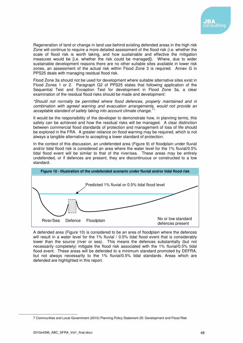
2010s4396_ABC_SFRA_Vol1_final.docx 48
Regeneration of land or change in land use behind existing defended areas in the high risk Zone will continue to require a more detailed assessment of the flood risk (i.e. whether the scale of flood risk is worth taking, and how sustainable and effective the mitigation measures would be [i.e. whether the risk could be managed]). Where, due to wider sustainable development reasons there are no other suitable sites available in lower risk zones, an assessment of the actual risk within Flood Zone 3 is required. Annex G in PPS25 deals with managing residual flood risk.
Flood Zone 3a should not be used for development where suitable alternative sites exist in Flood Zones 1 or 2. Paragraph G2 of PPS25 states that following application of the Sequential Test and Exception Test for development in Flood Zone 3a, a clear examination of the residual flood risks should be made and development:
“Should not normally be permitted where flood defences, properly maintained and in combination with agreed warning and evacuation arrangements, would not provide an acceptable standard of safety taking into account climate change.7”
It would be the responsibility of the developer to demonstrate how, in planning terms, this safety can be achieved and how the residual risks will be managed. A clear distinction between commercial flood standards of protection and management of loss of life should be explored in the FRA. A greater reliance on flood warning may be required, which is not always a tangible alternative to accepting a lower standard of protection.
In the context of this discussion, an undefended area (Figure 9) of floodplain under fluvial and/or tidal flood risk is considered an area where the water level for the 1% fluvial/0.5% tidal flood event will be similar to that of the river/sea. These areas may be entirely undefended, or if defences are present, they are discontinuous or constructed to a low standard.
Figure 10 - Illustration of the undefended scenario under fluvial and/or tidal flood risk
A defended area (Figure 10) is considered to be an area of floodplain where the defences will result in a water level for the 1% fluvial / 0.5% tidal flood event that is considerably lower than the source (river or sea). This means the defences substantially (but not necessarily completely) mitigate the flood risk associated with the 1% fluvial/0.5% tidal flood event. These areas will be defended to a minimum standard promoted by DEFRA, but not always necessarily to the 1% fluvial/0.5% tidal standards. Areas which are defended are highlighted in this report.
7 Communities and Local Government (2010) Planning Policy Statement 25: Development and Flood Risk
River/Sea Defence Floodplain
Predicted 1% fluvial or 0.5% tidal flood level
No or low standard defences present

2010s4396_ABC_SFRA_Vol1_final.docx 49
Figure 11 - Illustration of the defended scenario and residual flood risk behind fluvial/tidal defences
Undefended Areas – Flood Risk Mitigation
Within undefended or poorly defended Flood Zone 3a areas, floor levels for housing developments should, as a minimum, be situated above the acceptable standard of safety with sufficient freeboard to allow for uncertainties in flood level prediction and climate change. The following paragraphs define an appropriate standard of flood risk mitigation in undefended areas in the context of the Allerdale Borough Council SFRA.
The Sequential Test should be applied within the development location area, and it is considered appropriate to direct more vulnerable land uses to parts of the location at a lesser probability and lower residual risk of flooding. The lower floors of buildings in areas at both medium and high probability of flooding should seek to develop water-compatible and less vulnerable uses, including car parks or other public areas.
Housing developments (more vulnerable development) should provide a minimum habitable space floor level above the estimated 1% (for fluvial flooding) water level with the addition of allowances for modelling uncertainty and climate change (i.e. freeboard). This may be achieved by providing car parking or other public areas at ground floor level.
Employment development (less vulnerable development) should provide a similar standard of flood defence as housing developments. Within undefended or poorly defended Flood Zone 3a areas, employment development should remain dry during the 1% fluvial flood event, with sufficient freeboard to account for uncertainties in flood level prediction and climate change. Developers will need to carefully consider the commercial viability of developing in these areas. In exceptional circumstances, where there is significant planning justification for development and the provision of this standard of defence is not feasible, a greater acceptance of flood risk may be permitted for less vulnerable development in areas of high probability of flooding with the focus on providing safety to occupants, flood proofing and designing buildings to minimise flood damage.
Flood resilient construction may be considered in circumstances where there is a low probability of limited shallow depth water entry and buildings are not subjected to severe floodwater inundation depths. This type of construction is designed to reduce the consequences of flooding (the probability of flood occurrence remains unchanged) and facilitate recovery from the effects sooner than conventional buildings.
This may be achieved ‘through the use of water-resistant materials for floors, walls and fixtures and the positioning of electrical controls, cables and appliances at a higher than normal level’ and flood resistant construction to either reduce the amount of water or prevent entry of water into a building where resistant techniques are used. A means of safe access and egress in times of flooding must be provided so that at a minimum, emergency services and their vehicles are able to evacuate people, especially when considering those that are more vulnerable and/or with restricted mobility.
Whilst the basic level of protection afforded to residential and commercial development is the same, it is clear that approaches to how residual risk is managed may differ between
Lower residual risk area
Level inferred by Flood Zone Map
Level calculated from breach or overtopping River/Sea Defence Floodplain
2010s4396_ABC_SFRA_Vol1_final.docx 50
these two types of developments. For residential development residual risk is a societal issue, for which a presumption of avoidance and removal is appropriate. Hence a significant freeboard should be incorporated into housing development floor levels, whereas for a commercial property the end user and insurer can assess and transfer this residual risk as appropriate. Therefore, commercial and employment uses have a suitably different approach to the management of the residual risk, above that provided by the basic mitigation works. The onus would be on Allerdale Borough Council to determine whether these risks are acceptable, in conjunction with advice from the Environment Agency.
PPS25 advocates a risk-based approach linked to vulnerability and does not provide a prescriptive set of flood protection standards. Wherever possible, the highest achievable standard should be provided, but in exceptional circumstances, where alternative or complementary flood risk management measures can be taken and are sustainable, a lower standard may be acceptable. Care must be taken that such an approach would not result in future public expenditure on retrospective flood alleviation measures. Therefore, this approach is exceptional and only applicable in limited locations where the flood risks are fully understood.
Isolated small Greenfield developments may be sustainable in terms of their impact on floodplain storage and conveyance, however the cumulative effects of many small developments can be large and Greenfield sites must be viewed within a wider perspective.
Defended Areas - Flood Risk Mitigation
Within defended areas, residual flood risk is primarily associated with overtopping and/or breach of defences (and localised flooding associated with drainage systems in some locations). These risks are related to the likelihood (standard of protection and structural integrity of defences) and the consequences of flooding.
The likelihood of overtopping can be estimated by comparison of modelled water levels (where available) and defence crest levels. An indication of the likelihood of defence breach can be gained by reviewing the flood defence condition data held within the National Flood and Coastal Defence Database (NFCDD) and more detailed surveys and investigations undertaken by the Environment Agency and/or others. The consequences of defence overtopping or breach failure can be estimated using flood inundation modelling and mapping.
For a development to proceed, it must also be shown that it will not increase flood risk elsewhere through a loss of storage or conveyance. Flood risk must be reduced or kept at current levels.
Overtopping
Where assessments show an area to be at risk of defence overtopping in the 1% event (with climate change), measures should be employed to mitigate the risk. Where floor level raising is the preferred mitigation technique, minimum floor levels for housing developments should be set above the estimated water level that would result behind the defences (with an allowance for uncertainty and climate change). In exceptional circumstances, where there is significant planning justification for development and the provision of this standard of risk mitigation is not feasible, a lower degree of flood risk mitigation may be permitted in employment developments with the focus on providing safety to occupants, flood proofing and designing buildings to minimise flood damage.
Assuming it can be demonstrated that occupants remain safe a maximum inundation depth of 0.6m may be considered appropriate for the 1% event with the addition of allowances for modelling uncertainty and climate change. Minimum floor levels may be lower than the main river level if the floodplain is large.

2010s4396_ABC_SFRA_Vol1_final.docx 51
Where the defences consist of earth embankments, overtopping of the defences is likely to lead to erosion and weakening of the defence structure. In these circumstances failure of the defences is considered highly probable and an assessment of the consequences of defence breach is also required.
Breach
Where the defences are shown to be at risk of overtopping and/or NFCDD data or additional information indicate that the flood defences are in poor or very poor condition, for the purposes of the SFRA it may be assumed that there is a reasonable likelihood of defence breach in a major flood event during the lifetime of any new development. A high degree of flood risk mitigation needs therefore to be provided or it may be that due to the high risk, the location is deemed unsuitable for development. If mitigation measures are acceptable, then minimum floor levels in housing developments should be set above the estimated maximum breach water level for the 1% event with allowance for climate change and other uncertainties.
In locations where the defence is of a high standard, both in terms of stability and height, then the probability of a breach occurring is reduced and hence the risk reduces as well. The overall probability of the consequences associated with a breach occurring extend to the extreme end of the risk continuum. This does allow a more considered approach to residual risk, and some flooding of non-sensitive or vulnerable developments may be considered acceptable.
Where the defences are shown to provide a standard of protection greater than the 1% event (with climate change), NFCDD data indicate that the defences are in good or very good condition, and there is an absence of detailed survey data to suggest otherwise, for the purposes of the SFRA it may be assumed that the likelihood of defence failure in a major flood event is low. With the defences mitigating risk substantially, a lesser degree of site-based flood risk mitigation may be adopted, with the focus on providing safety to the development and its occupants from residual risks. Assuming it can be demonstrated that occupants remain safe, for housing developments it is recommended that minimum floor levels be set to the maximum breach level for a 1% event less 300mm, or 600mm above natural surface level, whichever is greater.
A maximum inundation depth of 0.6m may be considered acceptable when combined with the 1% (1 in 100 yr) event and a breach in these well defended areas in employment developments under these circumstances after consideration of uncertainty and climate change has been added to the minimum floor levels. However, occupants and users still need to remain safe. Identification of the rapid inundation zone is essential in these circumstances, before deploying a relaxation of the residual risk accepted within the design. In comparison to residential areas, where societal risks are generally designed out, it is considered appropriate to possibly transfer these residual risks via insurance or resilience in the design of the commercial use, if the users of the site can remain safe.
The effects of land raising within defended areas on potential breach risk also warrants careful consideration in the flood risk assessment. In confined floodplains where breach levels approach those in the main river, land raising is unlikely to have any impact on breach water levels and extents. However, where the floodplain is not confined by natural high ground or secondary defences, or where the passage of breach floodwater is restricted by partial barriers such as road or rail embankments, and consequently breach levels do not approach the main river level, then there is potential for land raising to lead to an increase in flood risk (extent and depth of breach) elsewhere. The potential for increasing breach related flood risk elsewhere is directly related to the loss of breach storage volume and conveyance, and single, small-scale developments are unlikely to have a significant impact. However, the cumulative effect of individual development proposals needs to be considered. Quantitative assessment of these effects may require detailed breach modelling to be undertaken in individual flood risk assessments. This guidance is not restricted to Zone 3a and applies to any site that is located with a defended area that is at risk of flooding from defence failure.

2010s4396_ABC_SFRA_Vol1_final.docx 52
Public Safety
For all Zone 3a allocations, and particularly in defended areas where a development site is close to a defence (i.e. within 500m), consideration must be given to residual risks and the risk to public safety associated with access and egress from properties. Residual risks are those associated with very low likelihood events, such as events of frequency less than 1% annual exceedance probability and failure of defences where defences provide a high standard of protection.
Development should not be sited where these risks unduly threaten public safety and/or the structural integrity of buildings and infrastructure. Early discussion with the Environment Agency, LPA and County Emergency Planning Officer is required in the consideration of the depth of flooding, flow velocity, rate of inundation and safe access / egress to assess these risks. This assessment is particularly applicable to areas at risk from both breach and overtopping.
There is a range of research and guidance available on flood hazards and public safety. DEFRA / Environment Agency Flood and Coastal Flood Defence Research and Development Programme, Project FD2317, Flood Risks to People consolidates flood hazard research from many sources.
The most recent flood hazard formula proposed by Phase 2 of the Risks to People Project is:
Flood hazard = d (v+0.5) +DF
Where:
d is depth m v is velocity ms-1 DF is the debris factor with a value of 0-1
A number of flood hazard thresholds have been identified describing a flood hazard as “Dangerous for some”, “Dangerous for most” and “Dangerous for all.” At present, the lower threshold for “dangerous for some” of 0.75 is appropriate with a conservative upper threshold of 1.5. The threshold of 2.5 for “Dangerous to all” has been set with a less conservative view and it should be noted that hazard is not purely a function of flood depth. Flood hazard thresholds are shown in Table 4 below.
Table 4 - Flood Hazard Thresholds
Flood Hazard d(v+0.5)+DF Description Alternative Name / Hazard Class
0 Safe (dry) None
0 to 0.75 Caution Low
0.75 to 1.5 Dangerous for some Moderate
1.5 to 2.5 Dangerous for most Significant
Over 2.5 Dangerous for all Extreme
For the purpose of the SFRA, it is considered appropriate to provide a low hazard environment in access and egress routes associated with new housing developments. Environment Agency guidance suggests that all development should have a dry access and egress in the 1% event. This should be the aim, but in exceptional circumstances a low hazard condition may be acceptable if the flood warning is robust and occupants remain safe. Greater depth and velocity may be permitted where elevated and safe access / egress to safe ground are provided.

2010s4396_ABC_SFRA_Vol1_final.docx 53
5.1.3 Planning Issues for Flood Zone 3b – The Functional Floodplain
PPS25 states that only the water-compatible uses are permissible in Flood Zone 3b. Essential Infrastructure can be permitted after the Exceptions Test is passed. According to PPS25, developers and local authorities should aim to:
� Reduce overall level of flood risk in the area through the layout and form of the development and the appropriate application of SUDS.
� Relocate existing development to land with a lower probability of flooding. In addition, according to PPS25, essential infrastructure should:
� Remain operational and safe for users in times of flood. � Result in no net loss of floodplain storage. � Not impede water flows. � Not increase flood risk elsewhere.
Other than water-compatible and essential infrastructure (subject to the Exception Test) uses, Flood Zone 3b should not be used for development except for access road purposes. In this case, the roadway should be kept to the narrowest width possible and crossing the watercourse at 90 degrees to the direction the watercourse flows.
5.1.4 Planning Issues for Flood Zone 2 – Medium Probability
Flood Zone 2 is considered suitable for water-compatible, less vulnerable, more vulnerable and essential infrastructure. Highly vulnerable development is only allowed where the Exception Test is passed.
In this zone, developers and Allerdale Borough Council should seek opportunities to reduce the overall level of flood risk in the area through the layout and form of the development, and the appropriate application of SUDS.
For highly vulnerable development in Flood Zone 2, this SFRA also indicates whether part c. of the Exception Test is most likely to be met.
Where development is implemented, floor levels should be situated, as a minimum, above the 1% AEP fluvial flood level with sufficient freeboard to account for inherent uncertainties with respect to flood level prediction and potential climate change scenarios. A site-specific FRA should be undertaken at the planning application stage to facilitate the delineation and definition of the 1% AEP fluvial flood event envelope.
5.1.5 Planning Issues for Flood Zone 1 – Low Probability
In accordance with PPS25, all development (essential infrastructure, highly vulnerable, more vulnerable, less vulnerable and water-compatible development) is permissible in Flood Zone.
For development proposals on sites comprising one hectare or more, the vulnerability to flooding from other sources as well as from river and sea flooding, and the potential to increase flood risk elsewhere through the addition of hard surfaces and the effect of the new development on surface water run-off, should be incorporated in a FRA.
In this zone, developers and local authorities should seek opportunities to reduce the overall level of flood risk in the area and beyond through the layout and form of the development, and the appropriate application of SUDS.
In situations where a known flooding problem has been identified downstream, Allerdale Borough Council will require developers to ensure that the proposed development does not result in a worsening of existing flooding conditions.

2010s4396_ABC_SFRA_Vol1_final.docx 54
5.1.6 Other Known Flood Risk Areas
In certain locations an increase in the rate of surface water runoff and/or volume from a new development situated upstream of an area that is known to be susceptible to localised flooding (e.g. as a result of problematic surface water drainage) may exacerbate the degree of flood risk to that downstream area.
Such areas will be sensitive to the drainage system implemented with that particular development site, as the drainage system will determine site runoff rates and volumes.
The capacity of drainage infrastructure is often limited and is at or near capacity under existing conditions. Development that leads to increased peak runoff within the drainage catchments may lead to infrastructure capacity being exceeded, with the potential for increased flood risk. As a result of being in a Critical Drainage Area a detailed FRA would be expected regardless of which Flood Zone that applies.
New developments upstream of these areas must be managed effectively to ensure that the impact upon downstream properties is fully mitigated. Wherever possible, this should be achieved through the implementation of a sustainable drainage or flow retention system, constructed within the boundaries of the development site.
Ideally, the LPA should work closely with the Environment Agency, sewerage undertakers and developers to enable surface water runoff to be controlled as near to the source as possible. For Greenfield developments, the aim is not to increase runoff from the undeveloped situation and for Brownfield re-developments, to reduce existing runoff rates. Wherever possible, this should be achieved through the implementation of a sustainable drainage or flow retention system, constructed within the boundaries of the development site.
A FRA will be required in each instance to demonstrate that new development is not at risk from flooding from existing drainage systems. The FRA should also demonstrate that the development would not adversely affect existing flooding conditions by the use of appropriate mitigation measures and should define and address the constraints that will govern the design of the drainage system.
The effectiveness of a flow management scheme within a single site is heavily limited by site constraints including (but not limited to) topography, geology (soil permeability), development density, adoption issues and available area. The design, construction and ongoing maintenance regime of such a scheme must be carefully defined at an early stage, and a clear and comprehensive understanding of the catchment hydrological processes (i.e. nature and capacity of the existing drainage system) is essential. In these areas a FRA will be required that demonstrates that the proposed development will not adversely affect existing flooding conditions either alone or in combination with other development.
Prior to making a planning application, discussions should be held with the Environment Agency, the Local Planning Authority and Northumbrian Water to ascertain the specific nature and most appropriate means of managing the flood risk.
The integration of drainage management is highlighted within the DEFRA strategy for flood risk management in England, detailed within the consultation document ‘Making Space for Water8'. The strategy aims to achieve better overall management of surface water drainage through better co-ordination between the different bodies.
5.2 Guidance for Flood Risk Assessments
As discussed earlier, there are principally three levels of flood risk assessment namely, Regional Flood Risk Appraisals (RFRAs), Strategic Flood Risk Assessments (SFRAs) and Site-specific (known as Detailed) Flood Risk Assessments (FRAs).
8 DEFRA (2004) Making Space for Water; Developing a New Government Strategy for Flood and Coastal Erosion Risk Management in England, A consultation Exercise. http://www.defra.gov.uk/environ/fcd/policy/strategy.htm

2010s4396_ABC_SFRA_Vol1_final.docx 55
The FRAs are site or project specific and are the responsibility of those proposing development to undertake. The principle aims of a FRA are to determine the acceptable management of flood risk to the development proposal itself and any impacts elsewhere, and to ensure that the development and its users/occupants remain safe in times of flood. The FRA will determine any effective flood mitigation measures necessary and include these in the development proposal. The FRA needs to demonstrate that the proposed development will not increase flood risk either upstream or downstream of the site and all sources of flood risk, including fluvial, surface water runoff and drainage need to be considered. The FRA will then be submitted to the LPA in support of the developers outline and/or detailed planning application.
Flood Risk Assessments for proposed development should follow the approach recommended by:
� The Environment Agency (see its National Standing Advice to Local Planning Authorities for Planning Applications – Development and Flood Risk in England (March 2007). See www.pipernetworking.com for all guidance on the scoping and undertaking of detailed FRAs.
� CIRIA Report C624 Development and Flood Risk – Guidance for the Construction Industry (2004)
� PPS25 and its Practice Guide. These documents describe when a FRA is required, what it should contain and are extremely helpful in guiding developers to produce a “fit for purpose” FRA and are commensurate with the advice given in this SFRA. All proposed development sites require at least an initial assessment of flood risks. A detailed FRA will be required for all developments that fall in the Flood Zone 2 and 3 and other sites where significant flood risk is identified. A full FRA will be required for sites in Flood Zone 1, which are greater than 1ha. For smaller sites a Screening Study will determine whether further FRA is required.
The information that follows serves to highlight key aspects of detailed FRAs and should be used in conjunction with the principle sources of information identified above.
5.2.1 General Principles
Annex E of PPS25 provides information on the general principles of flood risk assessment and states the minimum requirements for all stages of the planning process. These include:
� Be proportionate to the risk and appropriate to the scale, nature and location of the development;
� Consider the risk arising fro the development in addition to the risk of flooding to the development;
� Take the impacts of climate change into account; � Be undertaken as early as possible in the planning process; � Consider potential adverse and beneficial aspects of flood risk management
infrastructure; � Consider the vulnerability of the users of the development; � Consider and quantify difference types of flooding from all sources; � Include the assessment of residual risks; � Consider surface water drainage systems; and � Be supported by appropriate data and information.
Figure 3.5 of the Practice Guide provides information on the scope of FRAs and this should be used as a starting point for all development proposals and then supplemented to reflect any specific peculiarities or issues in respect of the particular development proposal or site under consideration.

2010s4396_ABC_SFRA_Vol1_final.docx 56
Information on levels of flood risk assessment is provided in both the CIRIA C624 Publication and Figure 3.4 of the Practice Guide. There are principally three levels of FRA:
Level 1 - Screening study, to identify whether there are any flooding or surface water management issues that need to be considered further;
Level 2 – Scoping study, to be undertaken if the Level 1 FRA indicates that there are flood risk issues needing further consideration and these risk can be readily quantified; and
Level 3 – Detailed study, where further quantitative analysis is required to appropriately assess flood related issues and determine any effective mitigation measures needed to be put in place.
Figure 3.6 in the Practice Guide provides a helpful list of typical sources of information to help undertake an appropriate FRA.
In addition, typical outputs of a Level 1 or Level 2 FRA, supported by guidance notes and a FRA pro-forma are contained in the Practice Guide and these include:
� Development description and location; � Definition of flood hazard; � Probability of flooding; � Effects of climate change; � Detailed development proposals; � Flood risk impacts and management measures; and � Consideration and management of off site and residual risks.
For all levels of FRA developers are advised to make early contact with the Environment Agency and the LPA to discuss their proposals in outline and consider the site in respect of the risk based sequential approach contained within the SFRA.
5.2.2 Assessment of Fluvial Risk
The mitigation design criterion for development within floodplain areas are generally set to protect against the flood event coinciding with a 1% annual probability of occurrence, including the impact of climate change. Detailed consideration will need to be given to the impact these mitigation measures may have and it is a requirement to ensure that flood risk is not increased elsewhere as a result of development. Compensation measures may take the form of compensatory flood storage as mitigation for loss of floodplain, enhanced flood defences and flood compatible master planning. Compensation measures will be needed in both defended and undefended floodplains. This concept is included in PPS 25 and ensures that residual risk is appropriately managed in new and existing development.
Before embarking on detailed modelling, and in light of this SFRA, proposals for development should be discussed in detail with the Environment Agency at an early stage.
Detailed FRAs may need to be carried out using hydraulic models. However, before any modelling is undertaken a review of available information should be conducted to assess if modelling is necessary. For fluvial floodplains an assessment of the hydrological regime is required. This should be undertaken using available gauged records and Flood Estimation Handbook (FEH) techniques. Where hydraulic modelling is necessary, it will need to include structures, such as bridges and weirs that influence flood levels. This modelling should also include floodplains to accurately determine the depth and extent of flooding.
Whenever possible models should be verified using historical records of flooding. Its sensitivity to modelling assumptions and climate change should also be investigated. Mapping the extent of flooding in a specific location will assist the risk of flooding to a specific development to be assessed.
Where allocations remain in high risk flood zone areas for other material considerations, it needs to be demonstrated that technically feasible flood mitigation options are available. A fuller appreciation of the sustainability of the site and its mitigation measures will be
2010s4396_ABC_SFRA_Vol1_final.docx 57
addressed via the Sustainability Appraisal. These measures must be designed to provide an appropriate level of flood mitigation to a site for the lifetime of the development. At most sites it is technically feasible to mitigate or manage flood risk (if potential off-site impacts are ignored), however the measures required may result in some practical constraints on development and/or require significant financial cost where flood risk is high. The detailed FRA should build on initial potential mitigation measures considered when determining the likelihood of the Exception Test being met as indicated earlier in this report.
5.2.3 Assessment of Surface Water Drainage Issues
Opportunities for developing an Integrated Water or Drainage Management Strategy across development site boundaries should be explored, and a catchment led approach should be adopted. This approach has been recognised in the consultation paper by Defra, Making Space for Water. An integrated approach to controlling surface water drainage can lead to a more efficient and reliable surface water management system as it enables a wider variety of potential flood mitigation options to be used. In addition to controlling flood risk, integrated management of surface water has potential benefits, including improved water quality and a reduction of water demand through grey water recycling.
Integrated drainage systems may be considered suitable for catchments where other development is being planned or constructed, and where on-site measures are set in isolation of the systems and processes downstream.
Surface water drainage assessments are required where proposed development may be susceptible to flooding from surface water drainage systems. The potential impact upon areas downstream of the development, including the impact on a receiving watercourse, also needs careful consideration.
The specific requirements for surface water drainage systems will need to be discussed with the Council’s Land Drainage Engineers, Environment Agency and the Water Company. Consideration should be given to whether a “Greenfield runoff approach” to the assessment of source control is appropriate. This method is generally satisfactory in the cases where the development is relatively small, isolated from other planned sites and the runoff processes are fully understood.
The FRA should then conclude with an assessment of the scale of the impact, and the recommended approach to controlling surface water discharge from a proposed development.
The recent Government consultation on surface water drainage as discussed in section 2.2.3 of this report should be considered when assessing surface water drainage as part of the FRA. In addition, Guidance for Developers and Regulators in Scotland on Drainage Impact Assessments has been produced by the Scottish Environment Protection Agency (SEPA) and others, and this is a valuable reference document.

2010s4396_ABC_SFRA_Vol1_final.docx 58
Appendices
A . Flood Risk Zones Zone 1: Low Probability
Definition This zone comprises land assessed as having a less than 1 in 1000 annual probability of river and sea flooding in any year (<0.1%). Appropriate uses All uses of land are appropriate in this zone FRA requirements For development proposals on sites comprising one hectare or above the vulnerability to flooding from other sources as well as from river and sea flooding, and the potential to increase flood risk elsewhere through the addition of hard surfaces and the effect of the new development on surface water run-off, should be incorporated in an FRA [Flood Risk Assessment]. This need only be brief unless the factors above or other local considerations require particular attention. See Annex E (of PPS25) for minimum requirements Policy aims In this zone, developers and local authorities should seek opportunities to reduce the overall level of flood risk in the area and beyond through the layout and form of the development and the appropriate application of sustainable drainage techniques.
Zone 2: Medium Probability
Definition This zone comprises land assessed as having between a 1 in 100 and 1 in 1000 annual probability of river flooding (1% – 0.1%) and between a 1 in 200 and 1 in 1000 annual probability of sea flooding (0.5% – 0.1%) in any year. Appropriate uses
The water-compatible, less vulnerable and more vulnerable uses of land and essential infrastructure listed in… [The Flood Risk Vulnerability Classification, see Table A-2] are appropriate in this zone. Subject to the Sequential Test being applied, the highly vulnerable uses in Table D.2 (of PPS25 and Table B-2 of this report) are only appropriate in this zone if the Exception Test is passed FRA requirements. All development proposals in this zone should be accompanied by a FRA. See Annex E (of PPS25) for minimum requirements Policy Aims In this zone, developers and local authorities should seek opportunities to reduce the overall level of flood risk in the area through the layout and form of the development and the appropriate application of sustainable drainage techniques.
Zone 3a: High Probability
Definition This zone comprises land assessed as having a 1 in 100 or greater annual probability of river flooding (>1%) and a 1 in 200 or greater annual probability of flooding from the sea (>0.5%) in any year. Appropriate uses The water-compatible and less vulnerable uses of land listed in Table D.2 (of PPS25 and Table A-2 of this report) are appropriate in this zone. The highly vulnerable uses listed in Table D.2 (of PPS25 and Table A-2 of this report) should not be permitted in this zone. The more vulnerable and essential infrastructure listed in the Table D.2 (of PPS25 and Table B-2 of this report) should only be permitted in this zone if the Exception Test is passed. Essential Infrastructure permitted in this zone should be designed and constructed to remain operational and safe for user in times of flood. FRA requirements All development proposals in this zone should be accompanied by a FRA, See Annex E (of PPS25) for minimum requirements. Policy Aims

2010s4396_ABC_SFRA_Vol1_final.docx 59
Zone 3a: High Probability
In this zone, developers and local authorities should seek opportunities to: 1. reduce the overall level of flood risk in the area through the layout and form of the development and the appropriate application of sustainable drainage techniques; 2. relocate existing development to land in lower Flood Zones; and 3. Create space for flooding to occur by restoring functional floodplain and flood flow pathways and by identifying, allocation and safeguarding open space for flood storage.
Zone 3b: Functional Floodplain
Definition This zone comprises land where water has to flow or be stored in times of flood Local planning authorities should identify in their SFRAs areas of functional floodplain and its boundaries accordingly, in agreement with the Environment Agency. The identification of functional floodplain should take account of local circumstances and not be defined solely on rigid probability parameters. But land which would flood with an annual probability of 1 in 20 (5%) or greater in any year, or is designed to flood in an extreme (0.1%) flood, should provide a starting point for consideration and discussions to identify the functional floodplain. Appropriate uses Only the water-compatible uses and the essential infrastructure listed in Table D.2 that has to be there should be permitted in this zone. It should be designed and constructed to: – remain operational and safe for users in times of flood; – result in no net loss of floodplain storage; – not impede water flows; and – not increase flood risk elsewhere. Essential infrastructure in this zone should pass the Exception Test. FRA requirements All development proposals in this zone should be accompanied by a FRA. See Annex E for minimum requirements. Policy aims In this zone, developers and local authorities should seek opportunities to: i. reduce the overall level of flood risk in the area through the layout and form of the development and the appropriate application of sustainable drainage techniques; and ii. relocate existing development to land with a lower probability of flooding.

2010s4396_ABC_SFRA_Vol1_final.docx 60
B . Flood Risk Classification
Classification Description
Essential Infrastructure • Essential transport infrastructure (including mass evacuation routes) which has to cross the area at risk.
• Essential utility infrastructure which has to be located in a flood risk area for operational reasons, including electricity generating power stations and grid and primary substations; and water treatment works that need to remain operational in times of flood.
• Wind turbines.
Highly Vulnerable • Police stations, Ambulance stations and Fire stations and Command Centres and telecommunications installations required to be operational during flooding.
• Emergency dispersal points. • Basement dwellings. • Caravans, mobile homes and park homes intended for
permanent residential use. • Installations requiring hazardous substances consent.19
(Where there is a demonstrable need to locate such installations for bulk storage of materials with port or other similar facilities, or such installations with energy infrastructure or carbon capture and storage installations, that require coastal or water-side locations, or need to be locate in other high flood risk areas, in these instances the facilities should be classified as ‘Essential Infrastructure).
More Vulnerable • Hospitals. • Residential institutions such as residential care homes,
children’s homes, social services homes, prisons and hostels. • Buildings used for: dwelling houses; student halls of
residence; drinking establishments; nightclubs; and hotels. • Non–residential uses for health services, nurseries and
educational establishments. • Landfill and sites used for waste management facilities for
hazardous waste. (2) • Sites used for holiday or short-let caravans and camping,
subject to a specific warming and evacuation plan
Less Vulnerable • Police, ambulance and fire stations which are not required to be operational during flooding.
• Buildings used for: shops; financial, professional and other services; restaurants and cafes; hot food takeaways; offices; general industry; storage and distribution; non–residential institutions not included in ‘more vulnerable’; and assembly and leisure.
• Land and buildings used for agriculture and forestry. • Waste treatment (except landfill and hazardous waste
facilities). • Minerals working and processing (except for sand and gravel
working). • Water treatment works which do not need to remain
operational during times of flood. • Sewage treatment works (if adequate measures to control
pollution and manage sewage during flooding events are in place).
Water-compatible Development
• Flood control infrastructure. • Water transmission infrastructure and pumping stations. • Sewage transmission infrastructure and pumping stations. • Sand and gravel workings.

2010s4396_ABC_SFRA_Vol1_final.docx 61
Classification Description
• Docks, marinas and wharves. • Navigation facilities. • MOD defence installations. • Ship building, repairing and dismantling, dockside fish
processing and refrigeration and compatible activities requiring a waterside location.
• Water-based recreation (excluding sleeping accommodation). • Lifeguard and coastguard stations. • Amenity open space, nature conservation and biodiversity,
outdoor sports and recreation and essential facilities such as changing rooms.
• Essential ancillary sleeping or residential accommodation for staff required by uses in this category, subject to a specific warning and evacuation plan.
Note 1: This classification is based on advice from the Environment Agency on the flood risks to people and the need of some uses to keep functioning during flooding. Note 2: Buildings that combine a mixture of uses should be placed into the higher of the relevant classes of flood risk sensitivity. Developments that allow uses to be distributed over the site may fall within several classes of flood sensitivity. (1) DETA Circular 04/00 – para. 18: Planning controls for hazardous substances. (2) See Planning for Sustainable Waste Management: Companion Guide to Planning Policy Statement 10 for definition.

2010s4396_ABC_SFRA_Vol1_final.docx 62
C . Development in the Flood Zones
Flood Zones Appropriate development
Development not permitted
Development allowed only if Exception Test
is passed
Site specific Flood Risk
Assessment
Flood Zone 1: Low Probability
All development: Essential infrastructure Highly vulnerable More vulnerable Less vulnerable Water-compatible development
N/A N/A FRA required for development proposals on sites of 1 ha or more1
Flood Zone 2: Medium Probability
Water-compatible Less vulnerable More vulnerable Essential infrastructure
N/A Highly vulnerable FRA required for all development
Flood Zone 3a: High Probability
Water-compatible Less vulnerable
Highly vulnerable More vulnerable Essential infrastructure
FRA required for all development
Flood Zone 3b: – The Functional Floodplain
Water-compatible Less vulnerable More vulnerable Highly vulnerable
Essential infrastructure
FRA required for all development
Table-Notes 1 Note 1: This need only be brief unless there are concerns about: a) the site’s vulnerability to flooding from other sources as well as from river and sea flooding and b) the development’s potential to increase flood risk elsewhere through the addition of hard surfaces and the effect of the new development on surface water runoff – or any other local considerations which require particular attention. Note 2: In this case, essential infrastructure should be designed and constructed to: a) remain operational in times of flood b) result in n net loss of floodplain storage c) not impede water flows and d) not increase flood risk elsewhere.

Offices at Atherstone Doncaster Edinburgh Haywards Heath Limerick Newcastle upon Tyne Northallerton Northampton Saltaire Skipton Tadcaster Wallingford Warrington Registered Office South Barn Broughton Hall SKIPTON North Yorkshire BD23 3AE t:+44(0)1756 799919 e:[email protected] Jeremy Benn Associates Ltd Registered in England 3246693
Visit our website: www.jbaconsulting.co.uk