allegheny passage geology garrett to rockwood
DESCRIPTION
DCNR Rails to RocksTRANSCRIPT

From Rails to Trails to RocksGeology of the Garrett-to-Rockwood Section
of the Allegheny Highlands Trailby
James R. Shaulis and Thomas W. Jones
COMMONWEALTH OF PENNSYLVANIADEPARTMENT OF CONSERVATION AND NATURAL RESOURCES
BUREAU OF TOPOGRAPHIC AND GEOLOGIC SURVEY
SOMERSET COUNTY RAILS-TO-TRAILS ASSOCIATION
SOMERSET COUNTY PARKS AND RECREATION BOARD
2004

ON THE COVER: Sixth grade student BJ Nicholas (alias “Clay Stone”)holds a piece of calcareous claystone full of the brachiopod Diaphrag-mus. The claystone was found in the Wymps Gap Limestone marineinterval at Geological Educational site GR–5.
This trail guide is a revision of an article published in 2000 by thePennsylvania Geological Survey in Pennsylvania Geology, v. 31,no. 1, p. 12–25. The authors have added information pertainingto the recently discovered Casselman River gorge landslide. Num-bered markers found along the trail correspond to the GeologicalEducational sites described in this guide.
PUBLISHED BY
COMMONWEALTH OF PENNSYLVANIAEdward G. Rendell, Governor
DEPARTMENT OF CONSERVATION AND NATURAL RESOURCESMichael DiBerardinis, Secretary
BUREAU OF TOPOGRAPHIC AND GEOLOGIC SURVEYJay B. Parrish, Director
SOMERSET COUNTY RAILS-TO-TRAILS ASSOCIATIONHank Parke, President
SOMERSET COUNTY PARKS AND RECREATION BOARDAnthony Marich, Jr., Chairman
Also available as a PDF on the Bureau of Topographic and Geologic Surveyweb site: www.dcnr.state.pa.us/topogeo
From Rails to Trails to RocksGeology of the Garrett-to-Rockwood Section
of the Allegheny Highlands Trailby James R. Shaulis1 and Thomas W. Jones2
ALL ABOARD—INTRODUCTION. Railroads were once smoky, rum-bling pathways that connected us to our mineral and energy re-sources, our industries, and to each other. Today, along many of thesesame pathways, the resources are depleted, the industries have dis-appeared, and the rail beds have been replaced with trails where trav-elers walk and bicycle instead of ride in passenger-train cars. Eventhough much has changed, these pathways still serve as connections.They now link us to healthy enjoyment of leisure time.
Through the identification of geologic features found along thesepathways, there exists the potential for these former roads of rails toconnect us to an educational resource, one that remains to help usbetter understand our earth and our history. Thus, in addition to thepursuit of fitness and fun, the trails link us to knowledge and under-standing of our physical world and environment.
NOW LEAVING THE STATION—FIELD TEST. In the spring of 1998,a “Rails to Rocks” pilot project was launched to develop educationalactivities in earth and environmental science for grades kindergartenthrough 12 (K–12). The project was based on geological features foundalong a 7-mile segment of the Allegheny Highlands Trail (between Gar-rett and Rockwood in Somerset County) and a 26-mile segment ofthe Youghiogheny River Trail North (between Connellsville and WestNewton in Fayette and Westmoreland Counties). Both trail sectionsare part of the Great Allegheny Passage, a 150-mile trail corridor thatbegins just west of Pittsburgh and continues southeastward to Cumber-land, Md. At Cumberland, the Great Allegheny Passage joins the C&OCanal Towpath, which extends to Washington, D. C. (see back cover).
The trail sections are located along abandoned railways that havebeen converted to public hiking and biking trails and are referred to as“rail trails.” During the spring and summer of 1998 and 1999, geologi-cally related features visible from the rail trails in these two sectionswere examined. Rock exposures and other natural features relatedto the geology of the region and determined to have significant edu-cational potential were described and interpreted. These features were
1
1Pennsylvania Department of Conservation and Natural Resources, Bureau of Topo-graphic and Geologic Survey, 3240 Schoolhouse Road, Middletown, PA 17057.
2Rockwood Area Elementary School, Rockwood, PA 17055.
2
designated as Geological Educational sites. Sites for the Garrett-to-Rockwood segment are shown in Figure 1.
Educators from the Pennsylvania State Department of Educationand local school districts, Bureau of Topographic and Geologic Sur-vey staff members, Bureau of State Parks Environmental InterpretiveNaturalists, Somerset County Parks and Recreation Board members,Youghiogheny River Trail Corporation board members, Rockwood Bor-ough Council and Water Authority members, Youghiogheny River TrailCouncil representatives, private consultants, and local experts all con-tributed to this project. Educational materials for use in teacher work-shops and outdoor classroom activities for grades K–12 were created(Jones and others, 1999; Jones and Shaulis, 1999).
LET ME HAVE THE WINDOW SEAT. Field trips for earth science stu-dents are more important to their mastery of the curriculum than forany other subject because many basic earth science concepts are dif-ficult to demonstrate in the classroom. Even though fossils and miner-als can be examined in hand specimens at a student’s desk, their con-nection to the earth can remain abstract until they are seen in a naturalexposure. Furthermore, because the geographical areas that rock for-mations and structures cover can be large, relating to them can be dif-ficult for beginning students. Layers of rock that extend many miles hori-zontally, or a geologic feature such as an anticlinal fold that extends forhundreds of feet vertically, can only be fully appreciated in the field.
YOU WILL SEE ROCKS AROUND EVERY BEND WHEN YOU RIDEON THIS “TERRAIN.” Earth science educators are handicapped inPennsylvania because extensive vegetation and thick soil cover ob-scure the bedrock. Because of this, opportunities to see bedrock ge-ology are primarily limited to exposures along highways, railroads,and rivers, or in quarries, which are commonly noisy, dirty, dangerous,difficult to access, and fraught with liability concerns. Although theseplaces may be suitable for college students and adults, they are notwell suited for use by elementary and secondary school students. How-ever, with the conversion of abandoned railroad beds into rail trails, ex-posures that were previously some of the most difficult and dangerousto visit and study are now the safest and easiest. Rock exposures andother geologically related features located along these rail-trail corridorsare quiet, safe, available year-round, liability-free, easy to access by bik-ing or hiking, and can be incorporated into K–12 earth science curricula.
A RAIL-TRAIL GEOLOGICAL EDUCATIONAL FANTASY TRIP—THETRAVEL AGENT’S NAME WAS ANN T. CLINE. Come travel back toa time when the climate was greatly warmer, when oceans were moun-

3
1850
1900
1800
1700
1600
1500 1400
1300
1200
1150
1850
1900
1800
1700
1600
1500
1400
1300
1200
wg
wg
wg
lk
lk
lk
lk
GR
-1
GR
-2
GR
-3
GR
-4
GR
-5
GR
-6
GR
-7G
R-8 G
R-9
AN
TICLIN
ALA
XIS
NE
GR
O
MO
UN
TAIN
Áa
Áp
Áp
Áp
Áa
Áa
Áa
Áa
Áa
Áa
Mm
c
Mm
c
Mm
cl
Mb
Qa
l
Qa
l
Lick
CA
SS
EL
MA
N
B
A
Mb
GR
-2A
lk
1.0
0.5
1.5
KM
0
1.0
MI
0.5
0
SC
ALE
18
00lk
Áp w
g
Mm
cl
Mb
An
ticl in
ala
xis
Ge
olo
gic
alE
du
ca
tio
na
lsite
Lo
ya
lha
nn
aM
em
be
r,in
fee
tS
tru
ctu
reco
nto
urs
on
the
ba
se
of
Allu
viu
m
Bu
rgo
on
Sa
nd
sto
ne
Lo
ya
lha
nn
aM
em
be
ro
fM
au
ch
Ch
un
kF
orm
atio
n
(Wym
ps
Ga
pL
ime
sto
ne
)M
au
ch
Ch
un
kF
orm
atio
n
Po
ttsville
Fo
rma
tio
n
(Lo
we
rK
itta
nn
ing
co
alb
ed
)A
lle
gh
en
yF
orm
atio
n
EX
PL
AN
AT
ION
Qa
l
Áa
Mm
c
N
S
WE
Figu
re 1
.G
eolo
gy o
f th
eG
arre
tt-t
o-R
ock
wo
od
sec
-ti
on o
f th
e A
llegh
eny
Hig
h-la
nds
Trai
l. G
eolo
gica
l Edu
-ca
tiona
l site
loca
tions
GR
–1th
roug
h G
R–9
are
sh
own
as c
ircl
ed d
ots.
A–B
is
the
line
of c
ross
sec
tion
sho
wn
in F
igur
e3
.
Bas
e m
ap
fro
m
the
follo
win
g U
.S. G
eolo
gi-
cal
Sur
vey
7.5
-min
ute
top
ogr
aph
ic q
uad
ran
-gl
e m
aps
pub
lish
ed i
n1
96
8 a
nd p
hoto
revi
sed
in
19
81
: M
arke
lto
n,
Mey
ersd
ale,
Mur
do
ck,
and
Ro
ckw
oo
d.
4
tains and mountains were oceans. See the results of the greatest col-lision ever experienced by North America. See the effects that morethan 200 million years of differential weathering has had on the land-scape. Hear an expert guide point out important geologic features andrelationships contained in the rock exposures that span 60 million yearsof geologic history along one of the most scenic routes of the Appa-lachian Plateaus province. See resources exposed in their natural set-ting and how society’s mining of these natural resources has affectedthe landscape and the environment.
What follows is a fictional transcript of the recollections of passen-ger Crystal Lynn from the first leg of a train ride between Garrett andWest Newton, Pa. Her notes were limited to comments made by tourguide Gemmy Euhedral Orthorhombic Edingtonite (BaAl2Si3O10·4H2O),geologist/educator, and student Clay Stone.
Mr. GEO Ed: My name is Gemmy Euhedral Orthorhombic Edington-ite, but you can call me Mr. GEO Ed. I will be your guide today for the“Negro Mountain Anticlinal Fold and Related Geologic Features” tour.
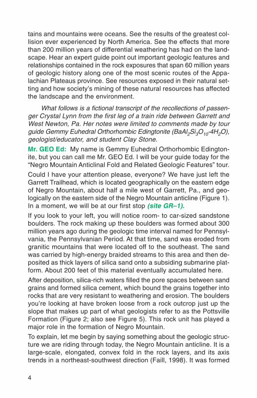
Could I have your attention please, everyone? We have just left theGarrett Trailhead, which is located geographically on the eastern edgeof Negro Mountain, about half a mile west of Garrett, Pa., and geo-logically on the eastern side of the Negro Mountain anticline (Figure 1).In a moment, we will be at our first stop (site GR–1).If you look to your left, you will notice room- to car-sized sandstoneboulders. The rock making up these boulders was formed about 300million years ago during the geologic time interval named for Pennsyl-vania, the Pennsylvanian Period. At that time, sand was eroded fromgranitic mountains that were located off to the southeast. The sandwas carried by high-energy braided streams to this area and then de-posited as thick layers of silica sand onto a subsiding submarine plat-form. About 200 feet of this material eventually accumulated here.
After deposition, silica-rich waters filled the pore spaces between sandgrains and formed silica cement, which bound the grains together intorocks that are very resistant to weathering and erosion. The bouldersyou’re looking at have broken loose from a rock outcrop just up theslope that makes up part of what geologists refer to as the PottsvilleFormation (Figure 2; also see Figure 5). This rock unit has played amajor role in the formation of Negro Mountain.
To explain, let me begin by saying something about the geologic struc-ture we are riding through today, the Negro Mountain anticline. It is alarge-scale, elongated, convex fold in the rock layers, and its axistrends in a northeast-southwest direction (Faill, 1998). It was formed

5
Figure 2. At a work-shop sponsored by theUniversity of Pitts-burgh at JohnstownCenter for Mathemat-ics and Science Edu-cation, teachers exam-ine one of many largePottsville boulders atsite GR–1.
when previously horizontal layers of rock were pushed up and folded200 million years ago during the mountain-building event known asthe Alleghanian orogeny.
Since that time, these rock layers have been undergoing weatheringand erosion. This process has removed softer rocks that once cov-ered Negro Mountain and has exposed the anticlinal mountain, whosecrest and slopes are made up of resistant sandstone layers of thePottsville Formation and the lower part of the Allegheny Formation.Allegheny Formation rocks lie on top of the Pottsville rocks.
Our route today parallels the Casselman River, which, fortunately forus, has cut through the anticline and exposed it, so we can also seethe rocks that are within (Figure 3).
Clay: Mr. GEO Ed, are you sure it’s safe for us to be riding throughhere?
Mr. GEO Ed: Why do you ask, Clay?
Clay: Well, couldn’t more boulders break loose up there and comedown and hit us?
Mr. GEO Ed: Oh, you don’t need to worry about that. I should havementioned that those boulders probably haven’t moved in about 10,000years (W. D. Sevon, oral commun., 1998). After they broke off from theoutcrop, they moved slowly downslope by means of a gravity-drivenprocess that involved freezing of the soil in the winter followed by slid-ing of the boulders during thawing in the summer. This process wasmost active during the last glacial period, about 18,000 to 24,000 yearsago (W. D. Sevon, oral commun., 1998). Even though there were noglaciers here, the climate was similar to present tundra climates, andfreeze-thaw activities on slopes were much more vigorous.

6
If you look out the window here (site GR–2), you will notice that thelayers of rock are tilted to the southeast and differ markedly in appear-ance from the Pottsville (Figure 4). They are thinly layered, olive-graysiltstones, sandstones, and limestones, or reddish-brown silty clay-stones. These rocks are in the middle to upper part of the Mississip-pian Mauch Chunk Formation and are stratigraphically several hun-dred feet lower than the Pennsylvanian Pottsville sandstone that wejust saw (Figure 5).
They are thus geologically older than the boulder-forming rocks. Oneproof of this is that Archeopteris (Gillespie and others, 1978), a fossil
Figure 4. MauchChunk strata aredipping 3 to 4degrees to thesoutheast at siteGR–2, which islocated on theeastern flank ofthe Negro Moun-tain anticline.
0 0.5 1.0 MI
0 0.5 1.0 1.5 KM
SCALE
Sto
ny B
atte
r R
un
Sha
fer
Run
Lick
Run
1800
2000
2200
2400
2600
1800
2000
2200
2400
2600
Lower Kittanning coal
Ben
d in
sec
tion
Neg
ro M
ount
ain
antic
linal
axi
s
2,00
0-fo
ot o
ffset
of s
ectio
n,so
uthw
est a
long
str
ike
DeerValley
WympsGap
Roc
kwoo
dTr
ailh
ead
Gat
e
Gar
rett
Trai
lhea
d G
ate
Pp
Pp
Pp
MmcMmc
Mmcl
Mb
Mmc
GR–1 GR–2 GR–3 GR–4 GR–5 GR–6 GR–7GR–8 GR–9
Elevation(feet)
Elevation(feet)
AB
Pa
Pa
Pa
Pa
Pa
Ben
d in
sec
tion
GR–2A
rhododen-drons
norhododendrons
Land
slid
e
rhododendronsV
V
V
V
V
Figure 3. Cross-section A–B through the Negro Mountain anticline shows thegeology and topographic profile (vertical exaggeration of approximately 12.5)a visitor to the trail would see when looking at the southwestern side of the Cas-selman River gorge between Garrett and Rockwood, Pa. The black dots markthe landslide area, and the green line marks the boundary between areas hav-ing rhododendrons (above) and having no rhododendrons (below). See Figure 1for the location of the section and an explanation of the symbols and colors.

MIS
SIS
SIP
PIA
NP
EN
NS
YL
VA
NIA
NUpper Kittanning coal
Johnstown Limestone
Ground surface
Middle Kittanning coal
Lower Kittanning coalGR–7, GR–8, GR–9
GR–6
GR–1
GR–2
Clarion coal
Brookville coal
Mercer coal complex
Sharon coal
Unconformity
Unconformity
Wymps Gap Limestone
GR–5
GR–3
R
R
R
R
R
R
RR
R
R
GR–4
GR–4
Deer Valley Limestone
LoyalhannaMember
MAUCHCHUNK
FORMATION
POTTSVILLEFORMATION
ALLEGHENYFORMATION
BURGOON SS
Limestone
EXPLANATION
Conglomerate
Sandstone
Siltstone
Shale
Coal
Red beds
GeologicalEducational
site
00
25
50FT
5
10
15
M
SCALE
GR–2A
7
Figure 5. A generalizedstratigraphic column forthe rocks exposed alongthe Garrett-to-Rockwoodsection of the AlleghenyHighland Trail.

8
fern having an age thatis limited to the Missis-sippian (Wagner, 1984),has been found here(Figure 6).
Further evidence of ourdifferent stratigraphicposition is the suddendisappearance of livingrhododendron plantsas we near the middleof the Mauch ChunkFormation (Figure 7).At this point, a changefrom noncalcareous tocalcareous strata oc-curs. Rhododendronsflourish in the acidicsoil derived from rocksin the upper part of theMauch Chunk Forma-tion, the Pottsville For-mation, and the lowerpart of the AlleghenyFormation, but theydo not thrive in the al-kaline soil formed onthe lower half of theMauch Chunk Forma-tion (R. C. Smith, II,oral commun., 1998;Figure 3). Therefore, adirect relationship be-tween the rock strataand the flora can be observed while riding through the Negro Moun-tain anticline. In approaching the axis of the anticline from either side,the rhododendrons disappear as calcareous, less acidic rocks of theMauch Chunk Formation are exposed.
The train has now traveled about half a mile further into the anti-cline without its occupants seeing any additional rhododendron whensuddenly Clay calls out.
Figure 6. At site GR–2, one of three known sitesin Pennsylvania that contain Mississippian-ageplant fossils, Archeopteris can be found.
Figure 7. Rhododendrons, nature’s “alkalinity in-dicators,” mark the boundary between the upper(less calcareous, more acidic) and lower (morecalcareous, less acidic) portions of the MauchChunk Formation at site GR–2. A hammer is be-ing held at the uppermost calcareous bed.
9
Clay: Mr. Geo Ed, rhododendrons everywhere you look! What’s goingon? Are we on the other side of the anticline already?
Mr. GEO Ed: No, Clay. We are still on the eastern flank of the anticline,and the acid-soil-producing rocks are outcropping 300 feet above us(site GR–2A). These plants shouldn’t be here. Maybe the answer toyour question can be found by taking a closer look in and around therhododendron plants. See anything familiar?
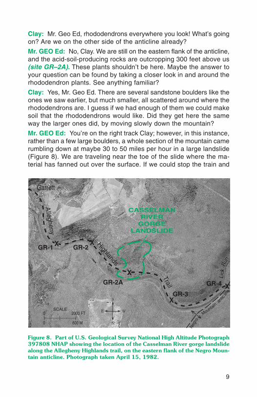
Clay: Yes, Mr. Geo Ed. There are several sandstone boulders like theones we saw earlier, but much smaller, all scattered around where therhododendrons are. I guess if we had enough of them we could makesoil that the rhododendrons would like. Did they get here the sameway the larger ones did, by moving slowly down the mountain?
Mr. GEO Ed: You’re on the right track Clay; however, in this instance,rather than a few large boulders, a whole section of the mountain camerumbling down at maybe 30 to 50 miles per hour in a large landslide(Figure 8). We are traveling near the toe of the slide where the ma-terial has fanned out over the surface. If we could stop the train and
Figure 8. Part of U.S. Geological Survey National High Altitude Photograph397808 NHAP showing the location of the Casselman River gorge landslidealong the Allegheny Highlands trail, on the eastern flank of the Negro Moun-tain anticline. Photograph taken April 15, 1982.
0
600 M
SCALE2000 FT
0
Lick
Run
Allegheny
Neg
ro
Mountainan
tic
line
Highlands
Trail
Garrett
CASSELMANRIVER
GORGELANDSLIDE
N
S
WE
v
v
GR-1 X X
X
X
X
GR-2
GR-2A
GR-3
GR-4

10
climb up near the top of the mountain where most of this materialcame from, we would see the scarp above the head of the slide. Thescarp is defined by a 40-foot cliff face and a depression between thebedrock cliff and the upper landslide blocks (H. L. Delano, oral com-mun., 2000; Figure 9). The landslide probably occurred about 10,000years ago under the same periglacial conditions of the Ice Age thatcaused the other boulders to move, but instead of taking hundreds orperhaps thousands of years to travel down the mountain, it may haveonly taken less than a minute.
As we move deeper into the anticline (site GR–3), you’ll notice thatthe beds are still inclined to the southeast but to a lesser degree, in-dicating that we are nearing the anticlinal axis, where the beds will beflat lying.
Clay: Mr. GEO Ed, what is the thick, gray rock layer having crisscrosslines all over it?
Mr. GEO Ed: I’m glad you asked, Clay. The thick gray rock is a festoon-crossbedded, sandy limestone known as the Loyalhanna Member of
SCALE
2300
2100
2000
1900
1000 FT
300 M
Elevation(feet)
2400
1865
2200
0
0
Rhododendron
Head
Scarp
Boulderdebrisfield
ToeGR–2A
Rup
tur e
surf
ace
Slip surface (low cohesive layer)
Pottsville
Formation
Cassel-manRiver
Wymps Gap Limestone
Mauch Chunk
Formation
Figure 9. Conceptual cross section of the Casselman River gorge landslide(site GR–2A) looking northwest into Negro Mountain. The cross section showshow an intact rock mass may have moved downslope.

11
the Mauch Chunk Formation. The festoon crossbedding that you no-ticed was formed by sand waves or submarine dunes that depositedtrough-shaped, thinly layered units that crosscut each other. Variationsin the composition of trough layers cause them to weather differen-tially, creating an uneven surface that delineates the intricate criss-cross bedding pattern in the rock (Figure 10).
Exposures of Loyalhanna limestone are visible on both sides of theCasselman River at this site. On the north side, entries to a largeunderground mine are present. The Loyalhanna limestone was quar-ried by the railroad for ballast and more recently is being used forroad aggregate.
We are now on the anticlinal axis (site GR–4). It is unfortunate thatthere are no good outcrops that we can see directly from the train,but if we had time, we could stop and walk up the streambeds in thisarea, and you would see that the rocks are flat lying.
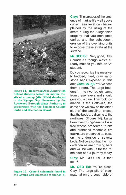
If you look out the window, you’ll see an excavated area adjacent tothe trail (site GR–5) that contains the Wymps Gap Limestone, a spe-cial rock unit in the middle part of the Mauch Chunk Formation. TheRockwood Borough Water Authority dug out this site in the spring of1999 to expose the fossiliferous layers (Figures 11, 12, and 13). TheWymps Gap Limestone has been interpreted to have been depositedin a nearshore marine environment (Brezinski, 1984). However, weare 1,900 feet above sea level now.
Who can explain to me how it’s possible for evidence of marine life to bepresent in the rocks here? OK, Clay, I will see how good your notes are.
Figure 10. Tom Jones,Rockwood Area Ele-mentary School scienceteacher, examines thedifferentially weatheredcrossbedding in theLoyalhanna limestonenear the axis of the Ne-gro Mountain anticline.Paleocurrent direction,indicated by the cross-bedding in the strata,is from right to left.
12
Clay: The paradox of the pres-ence of marine life well abovecurrent sea level can be ex-plained by the rising of thestrata during the Alleghanianorogeny that you mentionedearlier, and the subsequenterosion of the overlying unitsto expose these strata at thesurface.
Mr. GEO Ed: Very good, Clay.Sounds as though we’ve al-ready molded you into an “A”student.
Do you recognize the massive-ly bedded, hard, gray sand-stone beds exposed in thisarea (site GR–6)? You’ve seenthem before. The large boul-ders in the river below camefrom these layers and shouldgive you a clue. This rock for-mation is the Pottsville, thesame one we saw on the otherside of the anticline, exceptthat the beds are dipping to thenorthwest (Figure 14). Largebranches of Sigillaria, a fossiltree whose preserved trunksand branches resemble tiretracks, are preserved as castson the underside of severalbeds. Notice also that the rho-dodendrons are growing hereand will be with us for the re-mainder of our journey today.
Clay: Mr. GEO Ed, is thatcoal?
Mr. GEO Ed: You’re close,Clay. The large pile of blackmaterial on the south side of
Figure 11. Rockwood Area Junior HighSchool students search for marine fos-sils at a quarry (site GR–5) developedin the Wymps Gap Limestone by theRockwood Borough Water Authority incooperation with the Somerset CountyParks and Recreation Board.
Figure 12. Crinoid columnals found inthe Wymps Gap Limestone at site GR–5.

13
the trail (site GR–7) is waste-rock material produced during the under-ground mining of the Lower Kittanning coal seam in this area. Thismaterial was an impure part of the coal seam not suited for use in theelectrical power generation plant, so it was separated and left as awaste pile outside the mine.
Now direct your attention over there to the nonvegetated area in thewoods at the base of the slope, which is covered with orange-brownwater (site GR–8). This site is an underground-mine entry on the LowerKittanning coal seam. The orange-brown water that is flowing out ofthe hill here is acid mine drainage, or “AMD.”
Before AMD can occur, humid air must come in contact with freshlybroken rock surfaces containing pyrite. When this occurs, the follow-
Figure 13. A body fossil of the brachiopod genus Arthraco-spirifer (left) and a trilobite pygidium, probably from the genusPaladin (right), extracted from the thin, interbedded limestoneand claystone layers that make up the lower portion of the WympsGap Limestone marine interval.
Figure 14. At site GR–6,located on the westernflank of the Negro Moun-tain anticline, Pottsvillesandstone beds can beseen dipping 3 degreesto the northwest.

14
ing reaction takes place: FeS2 (pyrite) + O2 + H2O → Fe(OH)3 (solidiron hydroxide that colors the water orange brown) + SO4
2- (sulfate)+ H+ (acid) (Brady and others, 1998). Pyritic surfaces are commonlyexposed during the mining of bituminous coal. Groundwater travelingthrough fractures in the overlying rock percolates down into the mine,encounters these oxidized pyritic surfaces, and becomes acidic, creat-ing AMD. The AMD does not continue on down vertically because im-mediately under the coal seam lies several feet of claystone that actsas an impermeable barrier. Also, because all the mine workings areup the rock dip from us at this site, groundwater that has found itsway into the mine is being discharged here at the lowest opening.
Clay: Mr. GEO Ed, why aren’t the layers tilted here (site GR–9)? Arewe on the fold axis again?
Mr. GEO Ed: Good question, Clay. The rock layers in this area appearto be nearly horizontal even though we are still within the westernflank of the Negro Mountain anticlinal structure. The reason for thisappearance is that, for the first time today, our direction of travel haschanged, and we are now traveling parallel to the fold axis. The rocklayers thus appear flat even though they are actually dipping downtoward you and to the northwest.
Also at this exposure, you can see the Lower Kittanning coal seam,a gray underclay just below it, and a thickly layered, light-gray sand-stone immediately above it (Figure 15) (Flint, 1965). These are Penn-sylvanian-age rocks that are from the lower portion of the AlleghenyFormation. During the time these sediments were being deposited, thisarea was near the equator in a coastal-plain deltaic environment cov-
Figure 15. At siteGR–9, seventh gradescience students ex-amine the Lower Kit-tanning coal seam thatwas deep mined alongthe trail near Rock-wood in the PenelecNo. 3 mine from 1917to 1932. The averagethickness of the coalseam in the mine was29 inches.

15
ered with peat swamps. The peat has been altered through burial andis now present as coal.
During the early 1900s, this coal was deep mined and burned in a powerplant located near the large waste pile we just saw. If you look on theopposite side of the river, you can see several more waste piles fromother Lower Kittanning coal mines. Historically, coal mining has beenimportant to the economy in this area, but not as important as it wasto the area we will be visiting next. We are going to stop for a brief lay-over in Rockwood before continuing on.
The fantasy train ride will continue in a future issue of Pennsyl-vania Geology, when Mr. GEO Ed and Clay will examine the geologyin the heart of the Pittsburgh coal region, between Connellsville andWest Newton.
MAKING A 1-PERCENT GRADE IS PASSING FOR A LOCOMOTIVE—FIELD TEST RESULTS. The geoscience activities applicable to eachsite along the rail trail are being designed to support the PennsylvaniaDepartment of Education Academic Standards for Science and Tech-nology and Academic Standards for Environment and Ecology. Forexample, along the Garrett-to-Rockwood trail section, students canidentify various geologic structures and features, such as an anticlineat sites GR–2 through GR–6 and sedimentary crossbedding at siteGR–3. In addition, they can analyze the availability, location, and ex-traction of earth resources by studying Lower Kittanning coal seam de-posits at sites GR–7 through GR–9 and limestone deposits at site GR–3.
Teachers participating in the “Rails to Rocks” workshops offeredduring the 1998 and 1999 “Mathematics On Saturday/Science on Sat-urday” meetings, sponsored bythe University of Pittsburgh atJohnstown Center for Mathemat-ics and Science Education, ratedthe program as extremely use-ful and effective and suggestedthat it be made available for otherteachers. In future workshops,teachers will apply what theyhave learned to outdoor class-room instruction by developingon-site lessons and activities ap-plicable to the various rail-trailsites.
“We went from the traditionalfour-walled classroom to theopen outdoors where studentsshould be experiencing sci-ence. In this setting, teachershave the resources present torealistically back up textbooktheory with real evidence.”
—parochial high-school teacher,written commun., 1998

RAILS TO ROCKS, RESPECT, AND RESPONSIBILITY. Interconnec-tion is the goal of the “Rails to Rocks” project. It is hoped that afterparticipating in educational activities designed for the geologic sitesfound along these rail-trail routes, students will have learned some-thing about how the geology is connected to the topography, history,ecology, and economy of these regions, and as a result, will be betterprepared to make decisions that will affect the earth and its inhabitants.
A white paper drafted in March 1999 for use in the “GEO Beyond2000” strategic planning process by the Geosciences Directorate ofthe National Science Foundation contained a recommendation that inthe area of education, the number-one priority was to promote K–12geoscience education to ensure that the next generation of scientistsand the general public have a more thorough understanding of thenature and limits of geoscience research (Frodeman and Mitcham,1999). Charles Jordan, Director of the Portland (Oregon) Parks andRecreation Department, summed it up best: “What they don’t under-stand, they won’t appreciate; what they don’t appreciate, they won’trespect; what they don’t respect, they won’t value; and what theydon’t value, they won’t protect.”1 Connecting our students to the edu-cational resources found along Pennsylvania’s rail trails is a step ina lifelong journey to understanding, respecting, and preserving ourearth, which is truly our common wealth.
LIBRARY CAR—REFERENCES
Brady, K. B. C., Smith, M. W., and Schueck, J., 1998, Coal mine drainage predic-tion and pollution prevention in Pennsylvania: Department of Environmental Pro-tection, 200 p.
Brezinski, D. K., 1984, Dynamic lithostratigraphy and paleoecology of Upper Mis-sissippian strata of the northcentral Appalachian basin: University of Pittsburgh,Ph.D. thesis, 120 p.
Faill, R. T., 1998, A geologic history of the north-central Appalachians—Part 3,The Alleghany orogeny: American Journal of Science, v. 298, p. 131–179.
Flint, N. K., 1965, Geology and mineral resources of southern Somerset County,Pennsylvania: Pennsylvania Geological Survey, 4th ser., County Report 56A,267 p.
Frodeman, Robert, and Mitcham, Carl, 1999, Geophilosophy—philosophers andgeoscientists thinking together on the future of the earth sciences: GSA Today,v. 9, no. 7, p. 18–19.
Gillespie, W. H., Clendening, J. A., and Pfefferkorn, H. W., 1978, Plant fossils ofWest Virginia and adjacent areas: West Virginia Geological and Economic Sur-vey, Educational Series ED–3A, 172 p.
16
1From keynote address on the important role that outdoor educational programs playin the development of good citizens. Given at the Second International Trails and Green-ways Conference in Pittsburgh, June 1999.

Jones, Tom, McKinley, Bob, and Shaulis, James, 1999, Rails-to-rocks mobile work-shop—A guide to the Connellsville to West Newton railtrail: Alpha version, DECConsulting and Webmaster Services, 70 p.
Jones, Tom, and Shaulis, James, 1999, An educator’s guide to the geology of theRockwood to Garrett railtrail: Delta version, DEC Consulting and WebmasterServices, 72 p.
Wagner, R. H., 1984, Megafloral zones of the Carboniferous: International Congresson Carboniferous Stratigraphy and Geology, 9th, University of Illinois, Urbana-Champaign, Compte Rendu, v. 2, p. 109–134.
SUPPLEMENTARY READING
Buethin, J. D., 1997, Autocyclic and allocyclic controls on Late Mississippian-Penn-sylvanian sedimentation patterns: Sedimentary Geologists of Pennsylvania, 4thField Trip, University of Pittsburgh at Johnstown, 36 p.
Hamilton, R., and Ghatala, E., 1994, Learning and instruction: New York, McGraw-Hill.
Horne, J. C., and Ferm, J. C., 1979, The Carter Caves—Ashland area [field guide],in Ferm, J. C., and Horne, J. C., Carboniferous depositional environments inthe Appalachian region: Columbia, S. C., Carolina Coal Group, University of SouthCarolina, Department of Geology, p. 622–644.
Pettijohn, F. J., and Potter, P. E., 1964, Atlas and glossary of primary sedimen-tary structures: New York, Springer-Verlag, 370 p.
17

FOUR-HUNDRED-MILE-LONG TRAIL NETWORK FROMWASHINGTON, D. C., TO PITTSBURGH, PA.
WASHINGTON, D. C.
Harrisburg
HarpersFerry
Cumberland
GarrettRockwood
ConfluenceConnellsville
West Newton
McKeesport
PITTSBURGH
OHIO
VA.
W. VA. MD.PA.PA.
SCALE
80 KM
50 MI
0
0
80° 77°79° 78°
40°
39°
YOUGHIOGHENY
RIVER TRAIL
NORTH
YOUGHIOGHENY
RIVER TRAIL
SOUTH
C&O CANAL
TOWPATH
ALLEGHENY
HIGHLANDS
TRAIL
...... Location of trail segments used for “Rails to Rocks” pilot project