allan pulsipher and kathy perryallan pulsipher and … 22, 2011. research questions 1 ... • 23...
TRANSCRIPT

GEOGRAPHIC UNITS USED FOR SOCIOECONOMIC IMPACT
ANALYSIS IN H GUL O XICO GIONANALYSIS IN THE GULF OF MEXICO REGION
Allan Pulsipher and Kathy PerryAllan Pulsipher and Kathy PerryCenter for Energy StudiesLouisiana State University
March 22, 2011

Research QuestionsResearch Questions
1) Do the geographic units being used by BOEMRE for1) Do the geographic units being used by BOEMRE for planning purposes obscure or distort the potential socioeconomic impacts from offshore oil and gas ti it i f th i ti i l d dactivity in some of the regions or counties included
in the geographic unit?
2) Are there alternative units or approaches that will reduce or avoid such problems?
2

Geographic Units:Geographic Units:
• The 132‐county area identified as the potential affected area for federal offshore activities on the Gulf of Mexico is organized into
• 13 Economic Areas (EA) and subdivided further into• 13 Economic Areas (EA) and subdivided further into
• 23 Labor Market Areas (LMA).
From the tip of Florida to the Texas/Mexico borderthrough five states
3

DataData
• Industrial Clusters (17) from IBRC supported by EDA
NAICS E l d i Wh l D 2001 2008• NAICS Employment data via WholeData 2001 to 2008 for oil and gas and associated categories, as well as Travel/Recreation
4

Relative percent difference in location quotients of counties and Economic Areas (2008 energy sector employment)
5

Relative percent difference in location quotients of counties and Labor Market Areas (2008 energy sector employment)
6
Some Findings:Some Findings:
• N mero s instances of values calculated for 13• Numerous instances of values calculated for 13 Economic Areas (EAs) obscuring or distorting dimensions of the cluster or industry observable at the level of the 23 Labor Market Areas or 132 counties.
7

Categories of Distortion:Categories of Distortion:
• “Cancelling Out” Some EAs/LMAs are composed of i h diff i h diffcounties that are very different with very different
proportions of oil and gas activity that EA‐level measures tend to “cancel out.” EGs. TX‐1: Corpus Christi/Brownsville, LA‐3 Baton Rouge/Houma
• “Numerical Dominance” Some EAs/LMAs include counties that are so large relative to the others thatcounties that are so large relative to the others that even extreme concentrations or changes in smaller counties do not influence the unit totals. TX‐3: Houston/Galveston, LA‐1 Lake Charles (travel & recreation).
8

Categories of Distortion - cont.Categories of Distortion cont.
• “Meaningless Averages” Some counties in units are so different in relative importance and concentration that the average for the EA or LMA does not representthat the average for the EA or LMA does not represent any of the members. LA‐4 New Orleans
9

Data source: IBRC
10
Economic Areas—Energy (Fossil/Renewable)

3
Energy & Fossil Fuel Location Quotients (US) Labor Market Areas
Lafayette HoumaBrazoria
2
2.5
ent
Houston ‐Galveston
New Orleans
Baton Rouge
Corpus ChristiBeaumont ‐ Port Arthur
Mobile
Lake Charles
Pensacola
Victoria
Panama City1
1.5
Location
Quo
tie
LQ = 1.2
Miami Tampa‐St. Petersburg
Ft. Myers
Brownsville Sarasota
Biloxi‐GulfportTallahassee
Ocala
Gainesville
y
Lake City
0
0.5
Data source: IBRC
‐20% ‐10% 0% 10% 20% 30% 40% 50%
% Change in LQ 2001‐2008bubble size = 2008 employment
11
Labor Market Areas—Energy (Fossil/Renewable)

8
Oil and Gas Extraction Location Quotients Economic Areas
LA‐2
LA‐3LA‐4
TX‐3
5
6
7
tient
LA‐1
TX‐1
TX‐22
3
4
Location
Quo
AL‐1FL‐1
FL‐2 FL‐3FL‐4 MS‐1
0
1
2
‐150% ‐100% ‐50% 0% 50% 100% 150% 200% 250% 300%
LQ = 1.2
Data source: WholeData, 2008 County Business Patterns
‐150% ‐100% ‐50% 0% 50% 100% 150% 200% 250% 300%
% Employment Change 2001‐2008bubble size = 2008 employment
12
Economic Areas—Oil & Gas Extraction (NAICS 211)
Houma
25
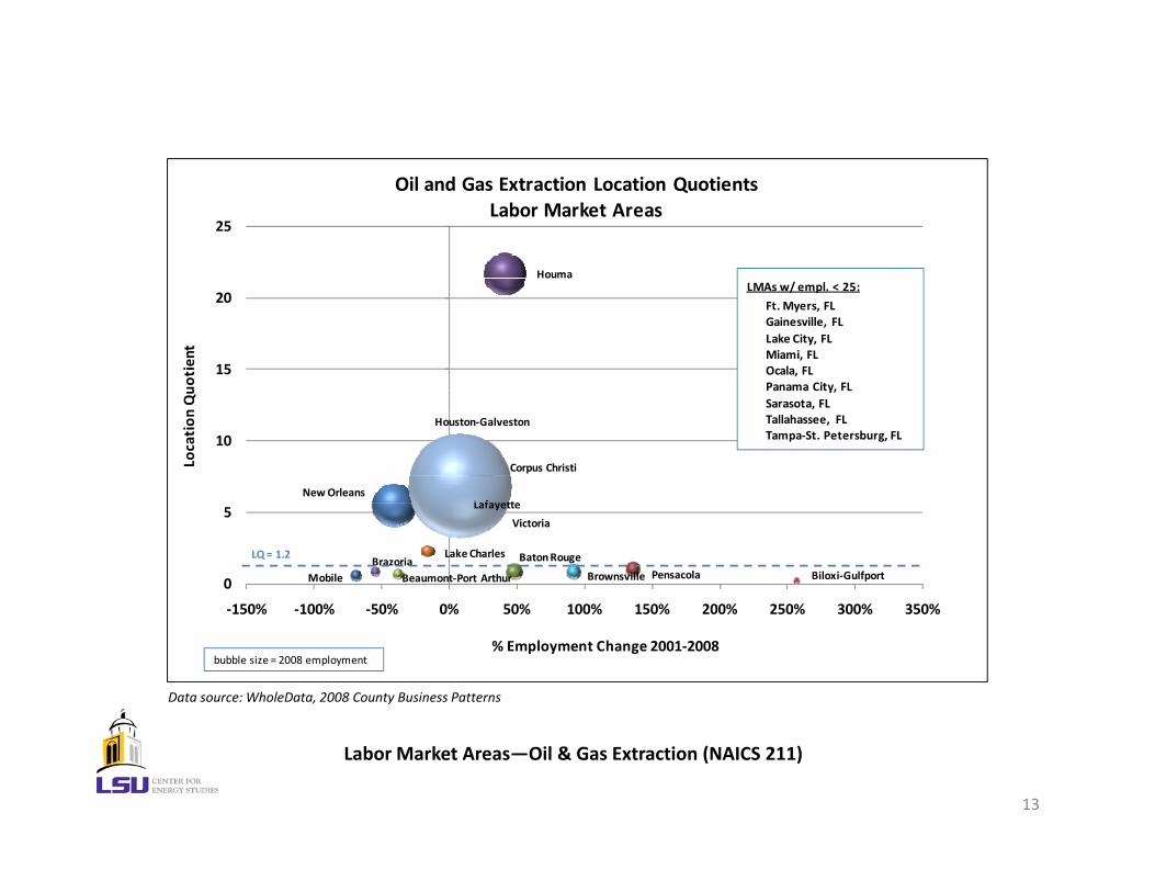
Oil and Gas Extraction Location Quotients Labor Market Areas
Houma
15
20
uotient
LMAs w/ empl. < 25:
Ft. Myers, FLGainesville, FLLake City, FLMiami, FLOcala, FLPanama City, FL
L f ttNew Orleans
Corpus Christi
Houston‐Galveston
10
Location
Qu Panama City, FL
Sarasota, FLTallahassee, FLTampa‐St. Petersburg, FL
Mobile Pensacola
Baton Rouge
Lafayette
Lake Charles
Biloxi‐GulfportBeaumont‐Port ArthurBrazoria
Brownsville
Victoria
0
5
‐150% ‐100% ‐50% 0% 50% 100% 150% 200% 250% 300% 350%
LQ = 1.2
Data source: WholeData, 2008 County Business Patterns
% Employment Change 2001‐2008bubble size = 2008 employment
13
Labor Market Areas—Oil & Gas Extraction (NAICS 211)

16
18
Drilling Oil and Gas Wells Location Quotients Economic Areas
EA / l i tLA‐2
10
12
14
16
otient
EA w/ no empl. in sector:
FL‐2 (Tallahassee/Lake City)
LA‐3
TX‐1
4
6
8
Location
Quo
AL‐1FL‐1FL‐3
FL‐4LA‐1LA‐4
MS‐1
TX‐2 TX‐3
‐2
0
2
200% 100% 0% 100% 200% 300% 400% 500% 600%
LQ = 1.2
‐200% ‐100% 0% 100% 200% 300% 400% 500% 600%
% Employment Change 2001‐2008bubble size = 2008 employment
Data source: WholeData, 2008 County Business Patterns
14
Economic Areas—Drilling Oil & Gas Wells (NAICS 213111)

23
Drilling Oil and Gas Wells Location Quotients Labor Market Areas
Houma
Lafayette
Corpus Christi
13
18
otient
Houston‐Galveston
8
Location
Qu LMAs w/ empl. < 25:
Mobile, ALBiloxi‐Gulfport, MSall Florida LMAs
Baton RougeLake Charles
New Orleans
Beaumont‐Port Arthur
Brazoria
BrownsvilleVictoria
‐2
3
‐200% ‐100% 0% 100% 200% 300% 400% 500% 600% 700%
LQ = 1.2
Data source: WholeData, 2008 County Business Patterns
% Employment Change 2001‐2008bubble size = 2008 employment
15
Labor Market Areas—Drilling Oil & Gas Wells (NAICS 213111)

3
Energy (Fossil/Renewable) Location Quotients (US) Counties in Houston‐Galv/Beaumont‐Pt. Arthur EA
ChambersHarris Jefferson
2
2.5
uotient
Fort Bend GalvestonHardin
Liberty
Montgomery
Orange
Waller1
1.5
Location
Qu
LQ = 1.2
Austin
Jasperiberty
NewtonOrange
PolkSan Jacinto
Tyler
Washington
0
0.5
‐100% ‐50% 0% 50% 100% 150%
% Change in LQ 2001‐2008bubble size = 2008 employment
Data source: IBRC
16
Houston‐Galveston/Beaumont‐Port Arthur Economic Area (TX‐3)

3.0
Travel and Recreation Location QuotientsLake Charles, LA Parishes (LA‐1)
Calcasieu2.0
2.5
ient
Cameron
1.0
1.5
Location
Quo
ti
LQ = 1.2
AllenBeauregardJefferson Davis
Vernon
0.0
0.5
‐60% ‐50% ‐40% ‐30% ‐20% ‐10% 0% 10% 20% 30% 40%
Data source: WholeData, 2008 County Business Patterns
60% 50% 40% 30% 20% 10% 0% 10% 20% 30% 40%
% Employment Change 2001‐2008bubble size = 2008 employment
17
Lake Charles Economic Area (LA‐1)

3.5
Energy (Fossil/Renewable) Location Quotients (US) Parishes in Lafayette EA
Acadia
IberiaLafayette
St MartinVermilion
2.5
3
otient
St. MartinVermilion
1
1.5
2
Location
Quo
LQ = 1.2
Evangeline
St. Landry
0
0.5
‐40% ‐30% ‐20% ‐10% 0% 10% 20% 30% 40% 50% 60%
L
Data source: IBRC
% Change in LQ 2001‐2008bubble size = 2008 employment
18
Lafayette Economic Area (LA‐2)

19

20