alfords point road upgrade - brushwood drive to … · 21/21268/178699 alfords point road...
TRANSCRIPT

Alfords Point Road Upgrade
Brushwood Drive to the Georges RiverReview of environmental factorsFebruary 2013
RMS 13.192 ISBN 978-1-922245-00-7


Roads and Maritime Services
Alfords Point Road Upgrade - Brushwood Drive to the
Georges River
Review of Environmental Factors
February 2013

i 21/21268/178699 Alfords Point Road Upgrade - Brushwood Drive to Georges River
Review of Environmental Factors
This Report has been prepared by GHD for Roads and Maritime Services (RMS) and may only be used and relied on by RMS for the purpose agreed between GHD and RMS as set out in Section 1.2 of this Report.
GHD otherwise disclaims responsibility to any person other than RMS arising in connection with this Report. GHD also excludes implied warranties and conditions, to the extent legally permissible.
The services undertaken by GHD in connection with preparing this Report were limited to those specifically detailed in the Report and are subject to the scope limitations set out in the Report.
The opinions, conclusions and any recommendations in this Report are based on conditions encountered and information reviewed at the date of preparation of the Report. GHD has no responsibility or obligation to update this Report to account for events or changes occurring subsequent to the date that the Report was prepared.
The opinions, conclusions and any recommendations in this Report are based on assumptions made by GHD described in this Report. GHD disclaims liability arising from any of the assumptions being incorrect

ii 21/21268/178699 Alfords Point Road Upgrade - Brushwood Drive to Georges River
Review of Environmental Factors
Executive summary
The proposal
The NSW Roads and Maritime Services (RMS) propose to upgrade about 2.1 kilometres of Alfords Point
Road from Brushwood Drive to the Georges River at Alfords Point (the proposal).
The key features of the proposal include:
Upgrade about 2.1 kilometres of Alfords Point Road from a four lane undivided carriageway to a six
lane divided carriageway. Alfords Point Road would be widened on the eastern side to accommodate
three lanes in each direction
Install a continuous concrete type F median barrier from the southern abutment of Alfords Point
Bridge to about 1.8 kilometres south to separate the northbound and southbound lanes
Provide emergency vehicle access via an opening in the central median barrier at the southern
abutment to Alfords Point Bridge
Widen the Brushwood Drive northbound on ramp to accommodate the relocated bus bay
Relocate the existing bus stop on the Brushwood Drive on ramp to about 80 metres south of the
existing location
Realign and extend the existing footpath to the new bus stop location. To provide pedestrian access
to the realigned footpath the existing noise wall opening at Eucalyptus Street would be reorientated
from its current north facing direction to a south facing direction (ie the opening would be
repositioned seven metres south and current opening closed)
Widen the single lane section of the Illawong/Alfords Point southbound off ramp to two lanes for a
length of about 300 metres. This would provide additional vehicle storage capacity on approach to
the roundabout intersection and prevent queuing onto Alfords Point Road southbound lanes
Replace the temporary bitumen shared path with a permanent off-road shared path on the eastern
side of Alfords Point Road. The shared path would extend the length of the proposal from Alfords
Point Bridge to the roundabout at the end of the Illawong/Alfords Point off ramp. Where the grades
are steep the shared path would be converted into separate cyclist and pedestrian paths for safety
reasons. A concrete type F barrier would be installed along the western side of the shared path to
separate it from the southbound carriageway
Relocate and reinstate the existing pedestrian path between Maxwell Close and the shared path on
the eastern side of Alfords Point Road
Relocate the existing heavy vehicle inspection bay to a permanent location beneath Old Illawarra
Road overbridge (900 metres south of Brushwood Drive on the southbound side of Alfords Point
Road). This would include permanent boundary fencing, lockable gates and lighting
Provide a vehicle breakdown bay on the southbound carriageway at the location of the existing
heavy vehicle inspection bay. The breakdown bay would be an extension of the road pavement and
be about 20 metres long and five metres wide
Subject to an assessment of feasible and reasonable noise mitigation options:
– Potentially provide a noise barrier on the western roadside edge of Alfords Point Road for about
700 metres to the north of the existing noise wall

iii 21/21268/178699 Alfords Point Road Upgrade - Brushwood Drive to Georges River
Review of Environmental Factors
– Potentially provide a noise barrier on the eastern side of Alfords Point Road for about one
kilometre between Maxwell Close and Brushwood Drive
Relocate the existing variable message sign located at the existing heavy vehicle inspection bay to
about 500 metres south of the existing location
Adjust the pavement drainage along the eastern side of Alfords Point Road and within the median
Construct a permanent swale drain and rock check dam at culvert outlets (300 metres and 1620
metres south of Alfords Point Bridge) and a permanent water quality basin 870 metres south of
Alfords Point Bridge
Relocate the optic fibre cables, light poles and underground electricity on the eastern and western
sides of Alfords Point Road to the outside edge of the widened Alfords Point Road. Provide a new
utility installation to supply power from Old Illawarra Road to the proposed heavy vehicle inspection
bay.
Need for the proposal
The proposal forms part of a broader plan to improve traffic flow along Alfords Point Road and through
the southern region of Sydney. Alfords Point Road is a key arterial road in southern Sydney, providing
access across the Georges River for motorists, cyclists and freight vehicles travelling between the
commercial and employment areas of Miranda and Bankstown. Alfords Point Road is currently operating
at capacity during peak periods and considerable delays are experienced at the Illawong/Alfords Point off
ramp and Brushwood Drive on ramp. RMS has been working to reduce congestion, improve travel times
and improve road safety on the route by completing the duplication of Alfords Point Bridge in 2008 and
the widening of Alfords Point Bridge northern approach in late 2011. The proposal would complement
these upgrades.
Alfords Point Road has a steep 9.7 per cent gradient immediately south of the existing heavy vehicle
inspection bay. Trucks leaving the inspection bay are unable to accelerate to a sufficient speed to merge
safely and efficiently with existing traffic on Alfords Point Road. This is causing a safety hazard as
vehicles slow down or change lanes to avoid slow moving trucks. The proposal would relocate the heavy
vehicle inspection bay to a safer location with a less steep grade and improved sight distances.
Options considered
A number of options within the existing Alfords Point Road corridor were considered for the proposal.
The options included widening Alfords Point Road to a six lane carriageway, widening Alfords Point Road
to a five lane carriageway and the ‘do nothing’ option. A number of design refinements were also
considered including the location of the heavy vehicle inspection bay, the location of the bus stop on
Brushwood Drive on ramp, and increasing the capacity of the Illawong/Alfords Point off ramp. The
preferred option that was selected would widen Alfords Point Road to a six lane carriageway including an
upgrade of the Brushwood Drive on ramp and the Illawong/Alfords Point off ramp. The selection of the
preferred option took into account social, environmental and economic factors as well as stakeholder
input and is considered to best achieve the proposal objectives.
Statutory and planning framework
Clause 94 of State Environmental Planning Policy (Infrastructure) 2007 permits development on any land
for the purpose of a road or road infrastructure facilities to be carried out by or on behalf of a public
authority without consent.
iv 21/21268/178699 Alfords Point Road Upgrade - Brushwood Drive to Georges River
Review of Environmental Factors
As the proposal is for the purpose of a road and is to be carried out by RMS, development consent from
council is not required and it is assessed under Part 5 of the Environmental Planning and Assessment
Act 1979 (EP&A Act).
Community and stakeholder consultation
During development of the proposal, consultation has been undertaken with the community and relevant
Government agencies and stakeholders. In July and August 2012, a community update brochure was
delivered to local residents and community information session and displays were held. The purpose of
the community consultation was to display the preliminary concept design and allow local residents and
road users to provide feedback. Feedback received from the community during consultation has been
used to refine the concept design.
In accordance with the RMS Procedure for Aboriginal Cultural Heritage Consultation and Investigation
(PACHCI), consultation was undertaken with Gandangara Local Aboriginal Land Council. This included
inviting them to participate in the archaeological survey of March 2012 and providing them with a copy of
the draft Aboriginal Archaeological Survey Report to comment.
In April and June 2012, a number of government agencies and stakeholders were contacted by letter and
provided with preliminary details of the proposal. The letters invited the agencies and stakeholders to
comment on the issues they would like addressed in the REF.
RMS will continue to undertake community and stakeholder consultation throughout development of the
proposal. In particular, the REF is placed on public display and comments invited. Submissions received
as a result of the REF display will be addressed in a formal submissions report and, if appropriate,
considered when finalising the concept design and during development of the detailed design.
Environmental impacts
Beneficial effects of the proposal would include:
Providing additional road capacity to accommodate the forecast traffic growth for the route
Improving operational efficiency and travel times on Alfords Point Road
Improving safety for heavy vehicles and through traffic
Traffic noise reductions for acutely noise affected residents
Improving safety and congestion at the Illawong/Alfords Point off ramp and Brushwood Drive on
ramp
Improving safety for buses accessing the bus stop on Brushwood Drive on ramp and reducing
conflict with other vehicles
Providing a permanent shared path between Brushwood Drive and Alfords Point Road
Improving pedestrian access to the bus stop on Brushwood Drive on ramp.
A number of adverse environmental effects are likely to occur during construction and operation of the
proposal, including:
Removal of 6.68 hectares of vegetation including 2.71 hectares of native vegetation
Traffic impacts, due to increased heavy vehicle movements on the existing road network during
construction
Noise and vibration impacts to properties adjacent to the proposal site during construction

v 21/21268/178699 Alfords Point Road Upgrade - Brushwood Drive to Georges River
Review of Environmental Factors
Disruptions to traffic flow and access during construction
Increased risk of degradation of water quality and drainage lines during construction
Increased risk for spills and contamination during construction
Increased risk of occurrence of erosion and sedimentation during construction
Potential temporary decline in air quality during construction
Increased potential for introduction of weed species during construction.
Adverse environmental effects would be adequately minimised, managed and mitigated through the
implementation of safeguards outlined in this review of environmental factors. This would include a
construction noise and vibration management plan, biodiversity management plan, soil and water
management plan and traffic management plan.
Justification and conclusion
The proposal is considered to be consistent with national, state and local strategies and plans as it would
address congestion issues on Alfords Point Road leading to improved efficiency, travel times and safety.
The proposal would also complement the upgrade of Alfords Point Bridge in 2008 and the northern
bridge approach in 2011, which would contribute to an improved strategic bus and freight route between
Miranda and Bankstown.
While there would be some environmental impacts as a consequence of the proposal, they have been
avoided or minimised wherever possible through design and site-specific safeguards. The beneficial
effects are considered to outweigh the mostly temporary adverse impacts and risks associated with the
proposal.
The proposal is subject to assessment under Part 5 of the EP&A Act. This REF has examined and taken
into account to the fullest extent possible all matters affecting or likely to affect the environment by
reason of the proposed activity. This has included consideration of conservation agreements and plans
of management under the National Parks and Wildlife Act 1974 (NPW Act), joint management and
biobanking agreements under the Threatened Species Conservation Act 1995 (TSC Act), wilderness
areas, critical habitat, impacts on threatened species, populations and ecological communities and their
habitats and other protected fauna and native plants.
The environmental impacts of the proposal are not likely to be significant and therefore it is not
necessary for an environmental impact statement to be prepared and approval to be sought for the
proposal from the Minister for Planning and Infrastructure under Part 5.1 of the EP&A Act. The proposal
is unlikely to affect threatened species, populations or ecological communities or their habitats, within the
meaning of the TSC Act or Fisheries Management Act 1994 (FM Act) and therefore a Species Impact
Statement is not required. The proposal is also unlikely to affect Commonwealth land or have an impact
on any matters of national environmental significance and therefore a referral to DSEWPaC for a
decision by the Commonwealth Minister for the Environment on whether assessment and approval is
required under the EPBC Act, is not required.
Display of the review of environmental factors
This review of environmental factors is on display for comment during March 2013 until April 2013. You
can access the documents in the following ways:
vi 21/21268/178699 Alfords Point Road Upgrade - Brushwood Drive to Georges River
Review of Environmental Factors
Internet
The documents would be available as pdf files on the RMS (former RTA) website at
www.rms.nsw.gov.au/roadprojects
You can request a copy by contacting the project team on 02 8849 2585.
Display
The documents can be viewed at the following locations until 5 April 2013:
Sutherland Library
30-36 Belmont Street, Sutherland
Monday to Firday 9am – 9pm
Saturday 9am – 4pm
Sunday 12pm – 4pm
Menai Library
34-40 Allison Crescent, Menai
Monday, Tuesday, Thursday 9.30am – 8pm
Wednesday and Friday 9.30am – 5pm
Saturday 9am -12pm
Padstow Motor Registry
Shop 1, 11 Cahors Road, Padstow
Monday to Friday 8.30am – 5pm
Saturday 8.30am – 12pm
How can I make a submission?
To make a submission on the proposal, please send your written comments to:
Alfords Point Road Southern Approach Upgrade project team:
Development Sydney
Roads and Maritime Services
PO Box 973
Parramatta NSW 2124
Email: [email protected]
Fax: 02 8849 2817
Submissions must be received by 5 April 2013.
Privacy information
All information included in submissions is collected for the sole purpose of assisting in the assessment of
this proposal. The information may be used during the environmental impact assessment process by
relevant Roads and Maritime Services staff and its contractors.
Where the respondent indicates at the time of supply of information that their submission should be kept
confidential, Roads and Maritime Services will attempt to keep it confidential. However there may be

vii 21/21268/178699 Alfords Point Road Upgrade - Brushwood Drive to Georges River
Review of Environmental Factors
legislative or legal justification for the release of the information, for example under the Government
Information (Public Access) Act 2009 or under subpoena or statutory instrument.
The supply of this information is voluntary. Each respondent has free access at all times to the
information provided by that respondent but not to any identifying information provided by other
respondents if a respondent has indicated that the representation should be kept confidential.
Any respondent may make a correction to the information that they have provided by writing to the same
address the submission was sent.
The information will be held by RMS, 27-31 Argyle Street, Parramatta.
What happens next?
Following the submissions period, Roads and Maritime Services will collate submissions.
Acknowledgement letters will be sent to each respondent. The details of submission authors will be
retained and authors will be subsequently advised when project information is released.
After consideration of community comments Roads and Maritime Services will determine whether the
proposal should proceed as proposed, or whether any alterations to the proposal are necessary. The
community will be kept informed regarding this Roads and Maritime Services determination.
If the proposal is approved, Roads and Maritime Services proceeds with final design and tenders are
called for construction of the project. The timing of these subsequent activities has not been confirmed.
If you have any queries, please contact Deanne Forrest (RMS Project Manager) on 02 8849 2585.

viii 21/21268/178699 Alfords Point Road Upgrade - Brushwood Drive to Georges River
Review of Environmental Factors
Contents
Executive summary ii
1. Introduction 1
1.1 Proposal identification 1
1.2 Purpose of the report 3
2. Need and options considered 9
2.1 Strategic need for the proposal 9
2.2 Existing road and infrastructure 12
2.3 Proposal objectives 13
2.4 Alternatives and options considered 14
2.5 Preferred option 19
2.6 Design refinements 20
3. Description of the proposal 23
3.1 The proposal 23
3.2 Design 24
3.3 Major design features 26
3.4 Construction activities 36
3.5 Ancillary facilities 43
3.6 Public utility adjustment 44
3.7 Property acquisition 45
4. Statutory and planning framework 46
4.1 State Environmental Planning Policies 46
4.2 Local Environmental Plans 54
4.3 Other relevant legislation 54
4.4 Commonwealth legislation 55
4.5 Confirmation of statutory position 55
5. Stakeholder and community consultation 56
5.1 Consultation strategy 56
5.2 Community involvement 56
5.3 Aboriginal community involvement 60
5.4 ISEPP consultation 60
5.5 Government agency and stakeholder involvement 62
5.6 Ongoing or future consultation 69
6. Environmental assessment 70

ix 21/21268/178699 Alfords Point Road Upgrade - Brushwood Drive to Georges River
Review of Environmental Factors
6.1 Noise and vibration 70
6.2 Biodiversity 94
6.3 Hydrology and drainage 118
6.4 Soils and water quality 124
6.5 Aboriginal cultural heritage 132
6.6 Non-Aboriginal heritage 135
6.7 Traffic and access 137
6.8 Landscape character and visual amenity 145
6.9 Air quality 156
6.10 Land use and property 158
6.11 Socio-economic 159
6.12 Waste management 161
6.13 Demand on resources 163
6.14 Hazards and risks 164
6.15 Climate change and greenhouse gases 166
6.16 Cumulative environmental impacts 168
6.17 Summary of beneficial effects 169
6.18 Summary of adverse effects 170
7. Environmental management 171
7.1 Environmental management plans (or system) 171
7.2 Summary of safeguards and management measures 171
7.3 Licensing and approvals 187
8. Conclusion 188
8.1 Justification 188
8.2 Objects of the EP&A Act 188
8.3 Ecologically sustainable development 189
8.4 Conclusion 191
9. Certification 192
10. References 193
Terms and acronyms used in this REF 195
Table Index
Table 2-1 Analysis of options 16
Table 3-1 Specific design criteria for the proposal 24
Table 3-2 Construction plant and equipment 40
Table 3-3 Indicative earthwork quantities 40
Table 3-4 Approximate quantity of materials required 41
x 21/21268/178699 Alfords Point Road Upgrade - Brushwood Drive to Georges River
Review of Environmental Factors
Table 5-1 Summary of issues raised by the local community 57
Table 5-4 Summary of government agency and stakeholder issues 63
Table 6-25 Key threatening processes relevant to the proposal 110
Table 6-26 Summary of TSC Act assessments of significance 113
Table 6-32 Site types identified in AHIMS database search 133
Table 6-35 Existing intersection performance 2011 140
Table 6-37 Intersection performance, 2016 (with and without the proposal) 143
Table 6-38 Intersection performance 2026 (with and without proposal) 144
Table 6-42 Current and projected climate change in the Sydney catchment 166
Table 7-1 Summary of site specific environmental safeguards 172
Table 7-2 Summary of licensing and approval required 187
Table 8-1 Objects of the EP&A Act 188
Figure Index
Figure 1-1 Regional context 4
Figure 1-2 The proposal 5
Figure 3-1 Indicative road cross section 600 metres south of Alfords Point Bridge 26
Figure 3-2 Indicative road cross section 800 metres south of Alfords Point Bridge 27
Figure 3-3 Indicative road cross section 1400 metres south of Alfords Point Bridge 27
Figure 3-4 Indicative road cross section 1600 metres south of Alfords Point Bridge 27
Figure 3-5 Illawong/Alfords Point off ramp and Brushwood Drive on ramp 29
Figure 3-6 Heavy vehicle inspection bay 30
Figure 3-7 Drainage features 33
Figure 6-1 Location of existing noise barrier 71
Figure 6-2 Noise catchment areas and monitoring locations (NCA 1 and 2a) 73
Figure 6-3 Noise catchment areas and monitoring locations (NCA 2b, 3 and 4) 74
Figure 6-4 Location of sensitive receivers nearest the heavy vehicle inspection bay 75
Figure 6-5 Vegetation mapping 96
Figure 6-6a-c Catchments and main discharge points 120
Figure 6-7 Existing road network 139
Figure 6-8 Road corridor at existing heavy vehicle inspection bay 146
Figure 6-9 Road corridor within typical cutting 147
Figure 6-10 Road corridor at proposed heavy vehicle inspection bay 147
Figure 6-11 Road corridor at bus stop on Brushwood Drive on ramp 148
Figure 6-12 Landscape character zones 149
Figure 6-13 Visual catchment and view points 151
Appendices
A Concept design plans

xi 21/21268/178699 Alfords Point Road Upgrade - Brushwood Drive to Georges River
Review of Environmental Factors
B Consideration of clause 228 (2) factors and matters of national environmental
significance
C Consultation material
D Background searches
E Biodiversity impact assessment
F Noise and vibration assessment
G Hydrology and drainage assessment
H Aboriginal heritage
I Non-Aboriginal heritage
J Traffic impact assessment
K Landscape character, visual impact assessment and urban design
L Greenhouse gas assessment

1 21/21268/178699 Alfords Point Road Upgrade - Brushwood Drive to Georges River
Review of Environmental Factors
1. Introduction
1.1 Proposal identification
The NSW Roads and Maritime Services (RMS) proposes to upgrade about 2.1 kilometres of Alfords
Point Road from Brushwood Drive to the Georges River (the proposal). The proposal is located at Alfords
Point about 30 kilometres south-west of the Sydney central business district (refer Figure 1-1). Alfords
Point is within the Sutherland Shire local government area and the RMS Sydney region.
The proposal is needed to improve traffic capacity and address congestion issues and would
complement the upgrade of Alfords Point Bridge (RTA, 2006) and its northern approach (RTA, 2007).
The key features of the proposal are shown in Figure 1-2 and include:
Upgrade about 2.1 kilometres of Alfords Point Road from a four lane undivided carriageway to a six
lane divided carriageway. Alfords Point Road would be widened on the eastern side to accommodate
three lanes in each direction
Install a continuous concrete type F median barrier from the southern abutment of Alfords Point
Bridge to about 1.8 kilometres south to separate the northbound and southbound lanes
Provide emergency vehicle access via an opening in the central median barrier at the southern
abutment to Alfords Point Bridge
Widen the Brushwood Drive northbound on ramp to accommodate the relocated bus bay
Relocate the existing bus stop on the Brushwood Drive on ramp to about 80 metres south of the
existing location
Realign and extend the existing footpath to the new bus stop location. To provide pedestrian access
to the realigned footpath the existing noise wall opening at Eucalyptus Street would be reorientated
from its current north facing direction to a south facing direction (ie the opening would be
repositioned seven metres south and current opening closed)
Widen the single lane section of the Illawong/Alfords Point southbound off ramp to two lanes for a
length of about 300 metres. This would provide additional vehicle storage capacity on approach to
the roundabout intersection and prevent queuing onto Alfords Point Road southbound lanes
Replace the temporary bitumen shared path with a permanent off-road shared path on the eastern
side of Alfords Point Road. The shared path would extend the length of the proposal from Alfords
Point Bridge to the roundabout at the end of the Illawong/Alfords Point off ramp. Where the grades
are steep the shared path would be converted into separate cyclist and pedestrian paths for safety
reasons. A concrete type F barrier would be installed along the western side of the shared path to
separate it from the southbound carriageway
Relocate and reinstate the existing pedestrian path between Maxwell Close and the shared path on
the eastern side of Alfords Point Road
Relocate the existing heavy vehicle inspection bay to a permanent location beneath Old Illawarra
Road overbridge (900 metres south of Brushwood Drive on the southbound side of Alfords Point
Road). This would include permanent boundary fencing, lockable gates and lighting
Provide a vehicle breakdown bay on the southbound carriageway at the location of the existing
heavy vehicle inspection bay. The breakdown bay would be an extension of the road pavement and
be about 20 metres long and five metres wide
Subject to assessment of feasible and reasonable noise mitigation options:
2 21/21268/178699 Alfords Point Road Upgrade - Brushwood Drive to Georges River
Review of Environmental Factors
– Potentially provide a noise barrier on the western roadside edge of Alfords Point Road for about
700 metres to the north of the existing noise wall
– Potentially provide a noise barrier on the eastern side of Alfords Point Road for about one
kilometre between Maxwell Close and Brushwood Drive
Relocate the existing variable message sign located at the existing heavy vehicle inspection bay to
about 500 metres south of the existing location
Adjust the pavement drainage along the eastern side of Alfords Point Road and within the median
Construct a permanent swale drain and rock check dam at culvert outlets (300 metres and 1620
metres south of Alfords Point Bridge)and a permanent water quality basin 870 metres south of
Alfords Point Bridge
Relocate the optic fibre cables, light poles and underground electricity on the eastern and western
sides of Alfords Point Road to the outside edge of the widened Alfords Point Road. Provide a new
utility installation to supply power from Old Illawarra Road to the proposed heavy vehicle inspection
bay.
The start and end points of the proposal include tie-ins to the existing alignment of Alfords Point Road.
Activities to tie the proposal into the existing alignment would be determined during detailed design and
may include pavement works where required to create consistent levels between existing and new
pavement.
To minimise traffic disruptions, the proposal is anticipated to be constructed in five main stages. This
would include staging construction on Brushwood Drive on ramp and the Illawong/Alfords Point off ramp,
as well as staging works on the eastern and western sides of Alfords Point Road. Further detail regarding
construction staging is provided in Section 3.4.2.
Construction of the proposal would require two temporary construction site compounds and a stockpile
site. The main construction site compound would be located on the triangle piece of land adjacent to the
Illawong/Alfords Point off ramp (refer Figure 1-2). This site would be about 2500 square metres and
accessed from the Illawong/Alfords Point Road off ramp. The secondary site compound would be located
400 metres south of the Old Illawarra Road overbridge (refer Figure 1-2). This site would be about 6000
square metres and accessed from Old Illawarra Road. Construction site compounds would be used to
stockpile materials, store plant and equipment, provide construction staff parking, toilets and amenities.
An additional stockpile and equipment storage area would also be required on the eastern side of Alfords
Point Road underneath the Old Illawarra Road overbridge.
Temporary construction sedimentation basins, if required, would be located within the road pavement
corridor. Construction of the proposal is anticipated to take about 24 months to complete (weather
permitting).
Construction of Alfords Point Road and the original Alfords Point Bridge (prior to 1973) included clearing
an additional area to cater for potential future widening of Alfords Point Road. As a result, the existing
Alfords Point Road corridor has sufficient width to cater for the proposal without substantial changes to
the landscape through cut and fill works or vegetation clearing.
Alfords Point Road is primarily used as an arterial road for commuters and freight between Miranda and
Bankstown, as well as a strategic bus corridor. An on ramp and off ramp at Brushwood Drive provide
local access to the residential areas of Padstow Heights, Alfords Point and Illawong.
For the purpose of this report, the ‘proposal site’ refers to the area that would be directly impacted by the
proposal, including the construction footprint.

3 21/21268/178699 Alfords Point Road Upgrade - Brushwood Drive to Georges River
Review of Environmental Factors
The proposal site is largely within an existing road corridor and the Georges River is a dominant feature
to the north of the proposal (refer Figure 1-2). Two minor culverts cross Alfords Point Road at 300 metres
and 1620 metres south of Alfords Point Bridge respectively. Road overbridges cross Alfords Point Road
at Brushwood Drive and Old Illawarra Road, and Alfords Point Bridge is located immediately north of the
proposal site.
The main surrounding land uses consist of low density residential properties at Alfords Point and
Illawong, and the Georges River National Park. The Sir Thomas Mitchell Aged Care Facility is located
adjacent to the proposal at the Illawong/Alfords Point Road off ramp.
1.2 Purpose of the report
This review of environmental factors (REF) has been prepared by GHD Pty Ltd on behalf of RMS Project
Development Sydney. For the purposes of these works, RMS is the proponent and the determining
authority under Part 5 of the Environmental Planning and Assessment Act 1979 (EP&A Act).
The purpose of the REF is to describe the proposal, to document the likely impacts of the proposal on
the environment, and to detail protective measures to be implemented.
The description of the proposed works and associated environmental impacts have been undertaken in
context of clause 228 of the Environmental Planning and Assessment Regulation 2000, the Threatened
Species Conservation Act 1995 (TSC Act), the Fisheries Management Act 1994 (FM Act), and the
Australian Government’s Environment Protection and Biodiversity Conservation Act 1999 (EPBC Act). In
doing so, the REF helps to fulfil the requirements of section 111 of the EP&A Act, that RMS examine and
take into account to the fullest extent possible, all matters affecting or likely to affect the environment by
reason of the activity.
The findings of the REF would be considered when assessing:
Whether the proposal is likely to have a significant impact on the environment and therefore the need
for an environmental impact statement to be prepared and approval to be sought from the Minister
for Planning and Infrastructure under Part 5.1 of the EP&A Act
The significance of any impact on threatened species as defined by the TSC Act and/or FM Act, in
section 5A of the EP&A Act and therefore the requirement for a Species Impact Statement
The potential for the proposal to significantly impact a matter of national environmental significance
or Commonwealth land and the need to make a referral to the Australian Government Department of
Sustainability, Environment, Water, Population and Communities for a decision by the
Commonwealth Minister for the Environment on whether assessment and approval is required under
the EPBC Act.
Level 15, 133 Castlereagh Street Sydney NSW 2000 T 61 2 9239 7100 F 61 2 9239 7199 E [email protected] W www.ghd.com.au
²³
²³
²³
S
²³
S
²³
S
GEORGES RIVER
AALLFFOORRDDSS PPOOIINNTT BBRRIIDDGGEE
FFOOWWLL
EERRRROO
A AD D
HEAVY VEHICLE INSPECTION BAYHEAVY VEHICLE INSPECTION BAY
OLD ILLAWARRA ROAD
MENAI ROAD
OLD ILLAWARRA ROAD
MENAI
ILLAWONG
ALFORDS POINT
PADSTOW HEIGHTS
REVESBY HEIGHTS
MENAI HIGH SCHOOLMENAI HIGH SCHOOL
THARAWAL PUBLIC SCHOOLTHARAWAL PUBLIC SCHOOL
ALFORDS POINT PUBLIC SCHOOLALFORDS POINT PUBLIC SCHOOL
SIR THOMAS MITCHELL AGED CARESIR THOMAS MITCHELL AGED CARE
HENRY LAWSON DRIVE
HENRY LAWSON DRIVE
BRUSHWOOD DRIVE
BRUSHWOOD DRIVE
THE RIVER ROADTHE RIVER ROAD
GERA
LD R
OAD
GERA
LD R
OAD
DILKE ROADDILKE ROAD
MOROTAI ROADMOROTAI ROAD
MORETON ROADMORETON ROAD
VILLIE
RS R
OAD
VILLIE
RS R
OAD
SANDAKAN ROADSANDAKAN ROAD
BURRAWANG REACH ROAD
BURRAWANG REACH ROAD
JERV
IS DR
IVEJE
RVIS
DRIVE
ALAMEIN ROADALAMEIN ROAD
VALL
EY R
OAD
VALL
EY R
OAD
THOMAS STREETTHOMAS STREET
MONA
SH R
OAD
MONA
SH R
OAD
LITTL
E MOO
N TRA
IL
LITTL
E MOO
N TRA
IL
OLD FERRY ROAD
OLD FERRY ROAD
PRIN
CE ST
REET
PRIN
CE ST
REET
MOON
S AVE
NUE
MOON
S AVE
NUE
THE RIDGE TRACK
THE RIDGE TRACK
YORREL TRAIL EAST
YORREL TRAIL EAST
BLAXLA
ND DRIVE
BLAXLA
ND DRIVE
HERITAGE DRIVEHERITAGE DRIVE
BEAUMARIS DRIVEBEAUMARIS DRIVE
CEDAR STREET
CEDAR STREET
MICKEYS POINT TRAILMICKEYS POINT TRAIL
LLAN
BERI
S DRI
VELL
ANBE
RIS D
RIVE
QUEENSBURY ROADQUEENSBURY ROAD
WILBUNG ROAD
WILBUNG ROAD
MARINER ROADMARINER ROADHOBART PLACE
HOBART PLACE
SYLVAN RIDGE DRIVESYLVAN RIDGE DRIVE
CLAN
CY ST
REET
CLAN
CY ST
REET
CHUR
CHILL
ROA
DCH
URCH
ILL R
OAD
HENR
Y KEN
DALL
AVEN
UEHE
NRY K
ENDA
LL AV
ENUE
HERITAGE TRAIL
HERITAGE TRAIL
OSPREY DRIVEOSPREY DRIVE
BROCKMAN AVENUE
BROCKMAN AVENUE
ROSEWAL
L DRIVE
ROSEWAL
L DRIVE
BAMPTON AVENUEBAMPTON AVENUE
CASUARINA ROADCASUARINA ROAD
CHARLOTTE PLACECHARLOTTE PLACE
ROMA AVENUEROMA AVENUE
MOONAH TRAIL
MOONAH TRAIL MOONAH ROAD
MOONAH ROAD
PALM
ER CL
OSE
PALM
ER CL
OSE
BURN
S ROA
DBU
RNS R
OAD
FERRIER
DRIVE
FERRIER
DRIVE
PHOENIX PLACEPHOENIX PLACE
COAC
HWOO
D CR
ESCE
NTCO
ACHW
OOD
CRES
CENT
SEID
EL AV
ENUE
SEID
EL AV
ENUE
TALO
MA ST
REET
TALO
MA ST
REET
SHAND CLOSESHAND CLOSE
TENNANT PLACETENNANT PLACE
CONN
OR PL
ACE
CONN
OR PL
ACE
JONQUIL PLACEJONQUIL PLACE
BUSH
LAND
DRI
VEBU
SHLA
ND D
RIVE
BERKLEY ROADBERKLEY ROAD
SEDGEMAN AVENUESEDGEMAN AVENUE
BACH
LI PL
ACE
BACH
LI PL
ACE
BERNARD ROADBERNARD ROAD
HILLTOP AVENUEHILLTOP AVENUE
SEWE
LL AV
ENUE
SEWE
LL AV
ENUE
ELKHORN PLACEELKHORN PLACE
KERS
HAW
ROAD
KERS
HAW
ROAD
CATTLE DUFFERS ROAD
CATTLE DUFFERS ROAD
GOOLAGONG PLACE
GOOLAGONG PLACE
ORIANA DRIVE
ORIANA DRIVE
BRAD
MAN RO
AD
BRAD
MAN RO
AD
DAVIDSON ROAD
DAVIDSON ROAD
ANGO
PHOR
A PLA
CEAN
GOPH
ORA P
LACE
FEWTRELL AVENUE
FEWTRELL AVENUE
MARL
OCK P
LACE
MARL
OCK P
LACE
WALES CLOSE
WALES CLOSE
LAVENDER PLACE
LAVENDER PLACE
BLACK CLOSE
BLACK CLOSE
NEEDLEWOOD GROVENEEDLEWOOD GROVE
KARRI PLACEKARRI PLACE
LAMBETH PLACE
LAMBETH PLACENAMB
UCCA
PLAC
ENA
MBUC
CA PL
ACE
PRIOR CLOSE
PRIOR CLOSE
BYRON PLACEBYRON PLACE
NALL
ADA R
OAD
NALL
ADA R
OAD
CLAIR
CRE
SCEN
TCL
AIR C
RESC
ENT
STAN
LEY W
ALK
STAN
LEY W
ALK
CYGNET PLACE
CYGNET PLACE
BELIN
DA R
OAD
BELIN
DA R
OAD
BASSIA PLACEBASSIA PLACE
BAUDIN CLOSEBAUDIN CLOSE
VON N
IDA PL
ACE
VON N
IDA PL
ACE
WALSH
CLOSE
WALSH
CLOSE
REGENT PLACE
REGENT PLACE
OCEAN PLACEOCEAN PLACE
EUCA
LYPT
US ST
REET
EUCA
LYPT
US ST
REET
LOMANDRA PLACELOMANDRA PLACE
JARR
AH C
LOSE
JARR
AH C
LOSE
OPAL PLACEOPAL PLACE
BLUE
BERR
Y PLA
CEBL
UEBE
RRY P
LACE
HAMELIN PLACE
HAMELIN PLACE
DEVL
IN PL
ACE
DEVL
IN PL
ACE
HYDE CLOSEHYDE CLOSE
KENT
IA PL
ACE
KENT
IA PL
ACE
TULIP CLOSETULIP CLOSE
TRIAL PLACETRIAL PLACE
OSPREY LANE
OSPREY LANEBARKER CLOSEBARKER CLOSE
QUIST
PLAC
E
QUIST
PLAC
E
GLYN
AVEN
UEGL
YN AV
ENUE
NAGLE CLOSENAGLE CLOSE
GEORGES RIVER
MILL CREEK
STILL CREEK
MORGANS CREEK
LITTLE SALT PAN CREEK
SALT PAN CREEK
G:\21\21268\GIS\Maps\MXD\21_21268_Z005_REF_RegionalContext.mxd© 2010. While GHD has taken care to ensure the accuracy of this product, GHD and NSW DEPARTMENT OF LANDS, GEOSCIENCE AUSTRALIA, make no representations or warranties about its accuracy, completeness or suitability for any particular purpose. GHD and NSW DEPARTMENT OF LANDS, GEOSCIENCE AUSTRALIA, cannot accept liability of any kind (whether in contract, tort or otherwise) for any expenses, losses, damages and/or costs (including indirect or consequential damage) which are or may be incurred as a result of the product being inaccurate, incomplete or unsuitable in any way and for any reason.
LEGEND
0 140 280 420 56070
MetresMap Projection: Transverse Mercator
Horizontal Datum: Geocentric Datum of Australia (GDA)Grid: Map Grid of Australia 1994, Zone 56
Figure 1.1
Job NumberRevision A
21-21268
18 Feb 2013o Date
Data Source: NSW Department of Lands: Cadastre - Jan 2011; Geoscience Australia: 250k Data - Jan 2011. Created by: sdwoodger
1:12,000 (at A3) Roads and Maritime ServicesAlfords Point Road Upgrade
Regional context
· 2010 Google²³
S Education Facillity²³ Community Facillity
Proposal site HighwaysMajor RoadsSecondary RoadsOther Roads
Waterways (lines)WatercourseGeorges River National Park
AALLFFOORRDDSS PPOOIINNTT RROOAADD


9 21/21268/178699 Alfords Point Road Upgrade - Brushwood Drive to Georges River
Review of Environmental Factors
2. Need and options considered
2.1 Strategic need for the proposal
The proposal forms part of a broader plan to improve traffic flow along Alfords Point Road and through
the southern region of Sydney. Alfords Point Road is a key arterial road in southern Sydney, providing
access across the Georges River for motorists, cyclists and freight vehicles travelling between the
commercial and employment areas of Miranda and Bankstown. RMS has been working to reduce
congestion, improve travel times and improve road safety on the route by completing the duplication of
Alfords Point Bridge in 2008 and the widening of Alfords Point Bridge northern approach in late 2011.
Alfords Point Road, between Alfords Point Bridge and Brushwood Drive, is currently a four lane
undivided road with two northbound and two southbound lanes. This section of Alfords Point Road is
currently operating at capacity during peak periods and considerable delays are experienced at the
Illawong/Alfords Point off ramp and the Brushwood Drive on ramp.
The on ramp from Brushwood Drive merges with Alfords Point Road and is not capable of efficiently
clearing the morning peak traffic. As a result, congestion occurs in the morning peak causing queues
along Brushwood Drive. The Illawong/Alfords Point off ramp from Alfords Point Road is primarily a single
lane which widens to two lanes about 200 metres before the intersection with Fowler Road, Old Illawarra
Road and Brushwood Drive. This off ramp becomes congested in the afternoon peak and queues extend
onto Alfords Point Road.
Between 2006 and 2010 there were 62 crashes along the three kilometre section of Alfords Point Road
between the Georges River and Menai Road. The majority of crashes (69.4 per cent) were rear-end
collisions, with a substantial number occurring at merge points at the Brushwood Drive on ramp and the
southern approach to Alfords Point Bridge.
Another safety issue on this section of Alfords Point Road is the location of the heavy vehicle inspection
bay. Alfords Point Road has a steep 9.7 per cent gradient immediately south of the existing heavy
vehicle inspection bay. This means trucks leaving the inspection bay are unable to accelerate to a
sufficient speed to merge safely and efficiently with existing traffic on Alfords Point Road. This is causing
a safety hazard as vehicles slow down or change lanes to avoid slow moving trucks.
2.1.1 Relevant strategies and plans
All relevant strategies and plans have been reviewed to determine the consistency of the proposal with
their aims and objectives. The review found that the proposal would contribute to achieving the aims and
objectives of the relevant strategic plans through the upgrade of a major transport route (Alfords Point
Road). The proposal would further contribute to the objectives of the various strategic plans by improving
road safety, reducing traffic congestion and improving alternate transport modes through the provision of
a shared path for pedestrians and cyclists.
National Road Safety Strategy 2011-2020
The National Road Safety Strategy 2011-2020 (Australian Transport Council, 2011) aims to reduce death
and serious injury on Australian roads. A target of this strategy is to reduce fatalities and crashes on our
roads by at least 30 per cent between 2011 and 2020.
The proposal would contribute to achieving this target by upgrading Alfords Point Road, reducing
congestion at merge points and improving operation of the road network, thereby reducing vehicle
accidents.

10 21/21268/178699 Alfords Point Road Upgrade - Brushwood Drive to Georges River
Review of Environmental Factors
The proposal has been designed in accordance with Austroads Guides and RMS supplements to
Austroads Guides for safe road operation. During construction, traffic management measures such as
reduced speed limit on Alfords Point Road would be implemented to ensure safe conditions for passing
motorists and workers on site.
NSW 2021: A plan to make NSW number one
NSW 2021 (NSW Government, 2011) is a 10 year plan with goals and targets to rebuild the economy,
provide quality services, renovate infrastructure, restore government accountability, and strengthen the
local environment and communities. It replaces the State Plan as the NSW Government’s strategic
business plan, setting priorities for action and guiding resource allocation. NSW 2021 lists a number of
actions to achieve these goals and targets including:
Reduce travel time
Improve road safety
Protect our natural environment.
The proposal would assist in achieving the goal of reducing travel times by increasing the capacity of
Alfords Point Road thereby reducing congestion (refer Section 6.7). Easing transport congestion and
reducing travel times is also one of the priority actions in NSW 2021 for improving the efficiency of
Sydney’s road network during peak times.
The proposal would improve road safety by improving merge points and thereby reducing the likelihood
of rear-end collisions. Road safety would also be improved by relocating the heavy vehicle inspection
bay to a location on Alfords Point Road with a reduced grade. A reduced grade would allow heavy
vehicles to re-enter traffic flows on Alfords Point Road at safer speeds.
The proposal has also been designed to minimise impacts on the natural environment as documented in
this REF.
The proposal is therefore consistent with NSW 2021.
Transport for NSW - Long Term Transport Master Plan
The Long Term Transport Master Plan was released by Transport for NSW in December 2012. It
identifies the key transport challenges for NSW over the next 20 years to support NSW development and
outlines specific actions to address these challenges. Though not addressed specifically, the proposal
supports one of the key measures identified by the master plan for ‘congestion management across
greater Sydney’s road network with targeted measures to reduce congestion, better use existing road
capacity and improve road safety’.
NSW Government State Infrastructure Strategy
The NSW Government State Infrastructure Strategy, released by the NSW Department of Premier and
Cabinet in December 2012, assists in understanding NSW infrastructure needs for the next 20 years,
particularly in light of key drivers for infrastructure demand in NSW including increased Sydney region
population and demand for freight movement. The strategy recognises that major arterial roads across
the wider Sydney road network will require improvement and that there will be value in addressing peak
hour congestion ‘hotspots’. Though the proposal is not specifically listed in the strategy, it is considered
to be consistent with this goal.
The previous strategy by NSW Government for 2008-09 to 2017-18 identified the duplication of Alfords
Point Bridge and the upgrade of the northern approach as key infrastructure projects within the Sydney
region. The proposal would complement these completed upgrades by upgrading the southern approach

11 21/21268/178699 Alfords Point Road Upgrade - Brushwood Drive to Georges River
Review of Environmental Factors
to Alfords Point Bridge and therefore providing continuity for the bridge duplication and northern
approach works.
NSW Bike Plan
The NSW Bike Plan (RTA and DECCW, 2010) is a comprehensive plan to encourage people to ride
more often and more safely in NSW. It details a 10 year plan for new bicycle infrastructure to be funded
by the NSW Government commitment of $158 million in the Metropolitan Transport Plan: Connecting the
City of Cities.
The NSW Bike Plan includes a number of actions to promote and improve cycling which are relevant to
the proposal. One of these actions includes providing shared pedestrian and cycle off-road facilities in all
appropriate locations as part of State road projects in the Greater Metropolitan Region.
The proposal would provide a permanent shared off-road pedestrian and cycle path.
RMS Corporate Delivery Plan - 2012 to 2013
The RMS Corporate Delivery Plan 2012-2013, released in August 2012, supersedes the previous RTA
Blueprint document and outlines specific project deliverables in line with strategy statements made in the
overarching RMS Corporate Strategy 2012 to 2016. The RMS Corporate Delivery Plan specifically
mentions the proposal in its deliverables;
Strategy: Deliver key infrastructure to support the safe, efficient and reliable movement of people and
goods
Deliverable: Complete the environmental impact assessment determination for Alfords Point Road,
Brushwood Drive to Georges River.
Sutherland Shire Guide for Shaping the Shire to 2030
The Guide for Shaping the Shire to 2030 is the strategic plan for the Sutherland Shire Council. It sets out
the goals and aspirations of the community for the future of the Shire including:
Well maintained and efficient critical infrastructure which meets current and future needs
Improved transport options, including well integrated cycling paths and footpaths.
The proposal is designed to provide additional capacity along Alfords Point Road and to improve traffic
efficiency. The proposal would also provide a permanent shared off-road pedestrian and cycle path and
therefore is consistent with the Guide for Shaping the Shire to 2030.
The Georges River Catchment Regional Planning Strategy
Strategic planning for the Georges River catchment includes a range of government initiatives to:
Embrace the diversity of the catchment – its natural diversity, social diversity and economic diversity
Identify, protect and provide for the improvement of significant natural and cultural heritage values
Improve natural resource management
Promote interest in catchment resources – improving management of and access to areas of natural
and cultural significance
Forge stronger communities – bringing community and government together through more effective
partnerships and catchment improvement projects.
A number of action plans have been developed to achieve these initiatives, including the Sydney
Metropolitan Catchment Action Plan 2009 (which incorporates the Southern Sydney Catchment Blueprint
2003 (DIPNR 2003)). The proposal supports a number of objectives of the Catchment Blueprint by

12 21/21268/178699 Alfords Point Road Upgrade - Brushwood Drive to Georges River
Review of Environmental Factors
upgrading the existing road drainage system and ensuring the existing spill containment devices and
gross pollutant traps have sufficient capacity to cater for the additional surface water runoff generated by
the proposal. The proposal also includes implementation of the safeguards and management measures
outlined in Section 7.2 which aim to protect water quality of the adjacent Georges River.
2.2 Existing road and infrastructure
2.2.1 Alfords Point Road
Alfords Point Road is a main arterial road connecting New Illawarra Road and Menai Road in the south
to Davies Road and Henry Lawson Drive in the north. The section of Alfords Point Road that is proposed
to be upgraded is immediately south of Alfords Point Bridge and is undivided with two 3.3 metre wide
lanes in each direction. Alfords Point Bridge crosses the Georges River in a north/south direction via two
lanes in each direction, providing continuity in the lane configuration between the northern and southern
bridge approaches.
The section of road corridor from Alfords Point Bridge to about 700 metres south is characterised by a
steep 9.7 per cent gradient and is enclosed by deep cuttings in several locations. A large area of fill
exists on the western side of Alfords Point Road between 700 and 1500 metres south of Alfords Point
Bridge, On the eastern side a smaller area of fill is located between 1500 and 1750 metres south of
Alfords Point Bridge. The corridor width varies from 35 to 40 metres within cuttings and between 80 to 90
metres where no cuttings exist. The posted speed limit is 80 km/h and access is restricted to the
following on and off ramps:
Illawong/Alfords Point off ramp (allows southbound vehicles to exit Alfords Point Road)
Brushwood Drive on ramp (allows vehicles to enter the northbound lanes of Alfords Point Road).
The exit lane for the Illawong/Alfords Point off ramp begins about 1.4 kilometres south of Alfords Point
Bridge. The exit lane allows vehicles to exit Alfords Point Road onto Fowler Road, Old Illawarra Road
and Brushwood Drive. This off ramp is a single lane before widening into two lanes about 60 metres
before the intersection with Fowler Road, Old Illawarra Road and Brushwood Drive.
The Brushwood Drive on ramp to Alfords Point Road is accessed by vehicles travelling in both directions
along Brushwood Drive. Vehicles entering the on ramp from both directions merge into a single lane
about 200 metres after entering. This single lane then merges with the existing two northbound lanes on
Alfords Point Road. A Veolia Transport bus stop is located half way down the western side of the
Brushwood Drive on ramp (service between Sutherland and Parramatta). The bus stop is accessed via a
pedestrian footpath at the end of Eucalyptus Street (Alfords Point). A 3.2 metre high noise wall is located
on the western boundary of the road corridor from the Brushwood Drive on ramp to a distance about 600
metres north. A gap in the noise wall at the end of Eucalyptus Street allows pedestrian access to the bus
stop. Vegetation has been planted between the noise wall and Alfords Point Road for the entire length.
An off-road temporary bitumen shared path is located adjacent to the southbound carriageway of Alfords
Point Road and provides a pedestrian and cyclist connection between Alfords Point Bridge and
Brushwood Drive. The shared path is relatively new (constructed in 2010) and in good condition. It runs
the length of the proposal, about 2.1 kilometres, and connects the local pedestrian networks in Alfords
Point and Illawong with the pedestrian network north of the Georges River. No lighting is provided along
the shared path. A pedestrian connection between the shared path and Maxwell Close is provided about
one kilometre south of Alfords Point Bridge.
A heavy vehicle inspection bay is located 900 metres south of Alfords Point Bridge in the southbound
shoulder. The heavy vehicle inspection bay is 140 metres long and 20 metres wide. The grade of slope
13 21/21268/178699 Alfords Point Road Upgrade - Brushwood Drive to Georges River
Review of Environmental Factors
along the section of Alfords Point Road south of the heavy vehicle inspection bay is very steep at 9.7 per
cent. A variable message sign is also located on the southbound shoulder of Alfords Point Road about
300 metres north of the heavy vehicle inspection bay.
About one kilometre south of the Illawong/Alfords Point off ramp and Brushwood Drive on ramp, Alfords
Point Road passes beneath the Old Illawarra Road overbridge. At this point there is a large area of
cleared road verge on the southbound side of Alfords Point Road.
There are no creek crossings or major cross drainage structures present in the proposal site. Minor cross
drainage for overland flow is provided through a 1050 millimetre diameter pipe culvert about 300 metres
south of Alfords Point Bridge and a 600 millimetre diameter pipe culvert about 1620 metres south of
Alfords Point Bridge. A gross pollutant trap/spill containment system is located at the southern abutment
of Alfords Point Bridge on the eastern side. The existing drainage infrastructure along Alfords Point Road
is shown in Figure 3-7. The Georges River is located immediately north of the proposal site. Longitudinal
drainage along Alfords Point Road discharges into Georges River National Park via several discharge
points. Longitudinal drainage infrastructure and drainage patterns are discussed further in Table 6-28.
Two Ausgrid overhead transmission lines and associated easements cross Alfords Point Road at about
300 and 720 metres south of Alfords Point Bridge. Vehicle access is provided to each easement via
gated fences from Alfords Point Road.
2.2.2 Brushwood Drive
Brushwood Drive is a two lane, two way local road with a posted speed limit of 50 km/h. It runs in a
north-south direction through Alfords Point before crossing Alfords Point Road and the proposal site via a
road overbridge. The road overbridge is located about two kilometres south of Alfords Point Bridge and
provides an east-west link between Alfords Point and Illawong. Brushwood Drive terminates on the
eastern side of the road overbridge at a roundabout controlled intersection with Old Illawarra Road and
Fowler Road. Brushwood Drive also provides left-turn and right-turn access to the northbound lanes of
Alfords Point Road via the Brushwood Drive on-ramp. Land use along Brushwood Drive is primarily
residential.
2.2.3 Fowler Road
Fowler Road is a two lane, two way local road with a posted speed limit of 50 km/h. From the intersection
with Brushwood Drive and Old Illawarra Road (roundabout), it runs east through the suburb of Illawong.
The predominant land use along Fowler Road is residential.
2.2.4 Old Illawarra Road
Old Illawarra Road is a two lane, two way local road, with a posted speed limit of 50 km/h. From the
intersection with Brushwood Drive and Fowler Road, it runs south-west, providing a link between
Illawong and Menai. Old Illawarra Road crosses Alfords Point Road via a road overbridge 900 metres
south of the Brushwood Drive road overbridge. From this point Old Illawarra Road becomes Menai Road
and continues in an east-west direction towards Menai and Sutherland. Old Illawarra Road also provides
access to the southbound lanes of Alfords Point Road via an on ramp where it crosses Alfords Point
Road.
2.3 Proposal objectives
The key objectives of the proposal are to:
Improve safety for all road users

14 21/21268/178699 Alfords Point Road Upgrade - Brushwood Drive to Georges River
Review of Environmental Factors
Reduce road crashes
Improve travel times and reduce congestion along Alfords Point Road
Minimise community issues
Improve the urban design and visual aspects of Alfords Point Road
Improve the drainage system on Alfords Point Road
Minimise environmental impacts.
2.4 Alternatives and options considered
2.4.1 Methodology for selection of preferred option
A number of options for the upgrade of Alfords Point Road were considered by RMS including the ‘do
nothing’ option. All of the options considered follow the existing Alfords Point Road alignment and are
within the existing road corridor. This allows the proposal to utilise the existing wide road corridor that
was originally constructed to cater for widening Alfords Point Road.
Each option was assessed against the proposal objectives outlined in Section 2.3. A risk management
workshop was held in June 2012 to identify potential risks associated with the proposal and the findings
considered during development of the various options.
The options that were considered are described in Section 2.4.2.
An analysis of the options against the proposal objectives is provided in Section 2.4.3.
In July and August 2012, community update brochures were delivered to residents in Alfords Point,
Menai and Illawong outlining the key features of the preliminary concept design. Community information
sessions and public displays were also held to display the preliminary concept design. The concept
design was refined based on this community feedback.
2.4.2 Identified options
The following options were considered.
Option 1 – Six lane carriageway
This option involves upgrading Alfords Point Road to three northbound and three southbound lanes for
two kilometres. This would provide an additional southbound and northbound lane between the southern
abutment of Alfords Point Bridge and Brushwood Drive. The northbound and southbound lanes would be
divided by a concrete type F barrier. This option would adopt a 3.3 metre lane width with a 0.5 metre
offset from the central median. The existing heavy vehicle inspection bay would be relocated south of
Brushwood Drive beneath the Old Illawarra Road overbridge.
Option 2 – Five lane carriageway
This option involves upgrading Alfords Point Road to:
Three northbound lanes for two kilometres from the southern abutment of Alfords Point Bridge to
Brushwood Drive
Two southbound lanes from the southern abutment of Alfords Point Bridge expanding to three lanes
at the heavy vehicle inspection bay to Brushwood Drive (about 800 metres in length).
The northbound and southbound lanes would be divided by a concrete type F barrier. This option would
retain the heavy vehicle inspection bay at its present location.

15 21/21268/178699 Alfords Point Road Upgrade - Brushwood Drive to Georges River
Review of Environmental Factors
Option 3 – Do nothing
The do nothing option involves not undertaking the proposal and retaining the existing four lane
undivided road. The heavy vehicle inspection bay would remain in its current location. Ongoing safety
and maintenance works on Alfords Point Road would be undertaken as required.
2.4.3 Analysis of options
Each of the options identified in Section 2.4.2 has been assessed against the proposal objectives. The
results of this assessment are provided in Table 2-1.

16 21/21268/178699 Alfords Point Road Upgrade - Brushwood Drive to Georges River Review of Environmental Factors
Table 2-1 Analysis of options
Objective Option 1 (six lane option) Option 2 (five lane option) Option 3 (do nothing)
Improved safety
and reduced road
crashes
This option would improve safety and reduce
road crashes by increasing sight distances
and removing the merge point at Brushwood
Drive on ramp including the conflict between
buses and vehicles. The concrete barrier
separating the northbound and southbound
lanes would contribute to a reduction in head
on collisions.
This option would also move the heavy
vehicle inspection bay to a location where
trucks exiting the bay could accelerate to
higher speeds before merging with traffic.
This would remove the need for trucks having
to make an unsafe lane change to merge
with through traffic travelling at a speed
differential of more than 20 km/h.
This option would improve safety and
reduce road crashes by increasing sight
distances and removing the merge point at
Brushwood Drive on ramp including the
conflict between buses and vehicles. The
concrete barrier separating the northbound
and southbound lanes would contribute to a
reduction in head on collisions.
The merge point south of Alfords Point
Bridge would remain unchanged and
southbound vehicles would merge from
three lanes to two lanes when leaving
Alfords Point Bridge. This merge point
causes congestion resulting in potential
nose to tail collisions.
This option would retain the heavy vehicle
inspection bay at its current location. Trucks
exiting the bay would therefore be required
to accelerate up a steep grade and change
lanes to make a potentially unsafe merge
with through traffic travelling at a speed
differential of more than 20 km/h.
Currently there is no
dividing barrier between the
northbound and
southbound lanes. The risk
of head on collisions is high
as this section of road is a
high speed, steep gradient
road, with a high
percentage of heavy
vehicles.
No improved safety or
reduction in road crashes
would be achieved.
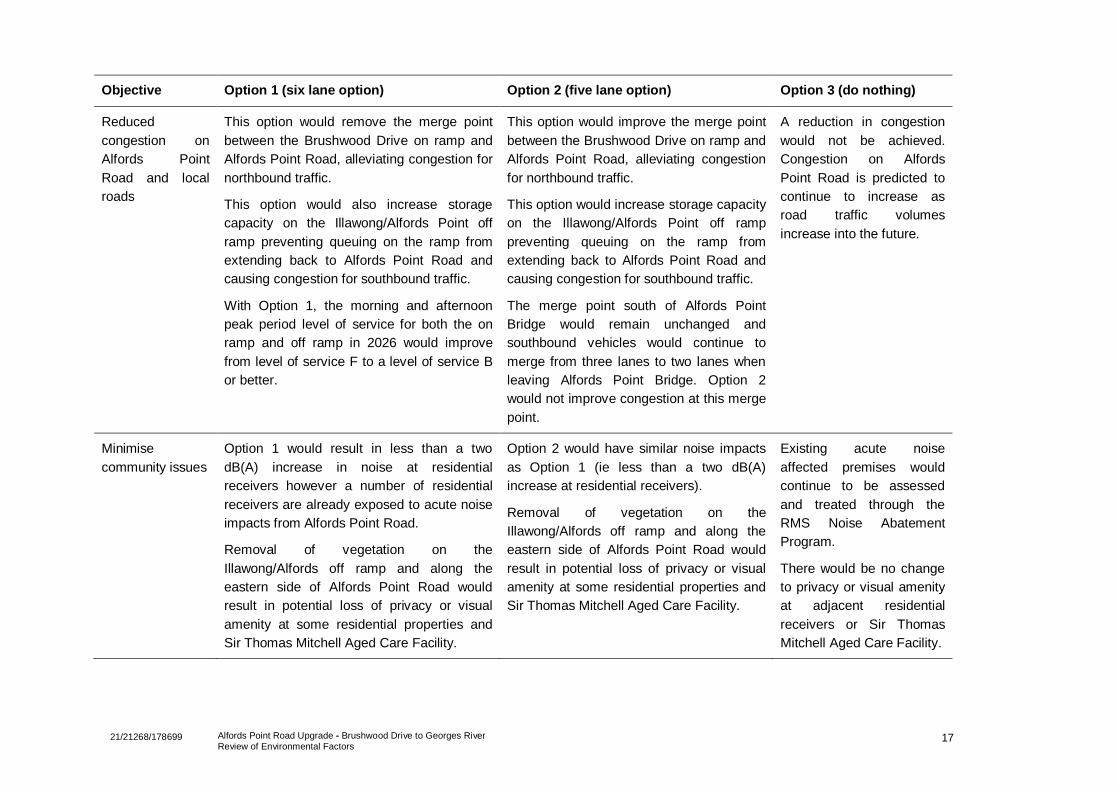
17 21/21268/178699 Alfords Point Road Upgrade - Brushwood Drive to Georges River Review of Environmental Factors
Objective Option 1 (six lane option) Option 2 (five lane option) Option 3 (do nothing)
Reduced
congestion on
Alfords Point
Road and local
roads
This option would remove the merge point
between the Brushwood Drive on ramp and
Alfords Point Road, alleviating congestion for
northbound traffic.
This option would also increase storage
capacity on the Illawong/Alfords Point off
ramp preventing queuing on the ramp from
extending back to Alfords Point Road and
causing congestion for southbound traffic.
With Option 1, the morning and afternoon
peak period level of service for both the on
ramp and off ramp in 2026 would improve
from level of service F to a level of service B
or better.
This option would improve the merge point
between the Brushwood Drive on ramp and
Alfords Point Road, alleviating congestion
for northbound traffic.
This option would increase storage capacity
on the Illawong/Alfords Point off ramp
preventing queuing on the ramp from
extending back to Alfords Point Road and
causing congestion for southbound traffic.
The merge point south of Alfords Point
Bridge would remain unchanged and
southbound vehicles would continue to
merge from three lanes to two lanes when
leaving Alfords Point Bridge. Option 2
would not improve congestion at this merge
point.
A reduction in congestion
would not be achieved.
Congestion on Alfords
Point Road is predicted to
continue to increase as
road traffic volumes
increase into the future.
Minimise
community issues
Option 1 would result in less than a two
dB(A) increase in noise at residential
receivers however a number of residential
receivers are already exposed to acute noise
impacts from Alfords Point Road.
Removal of vegetation on the
Illawong/Alfords off ramp and along the
eastern side of Alfords Point Road would
result in potential loss of privacy or visual
amenity at some residential properties and
Sir Thomas Mitchell Aged Care Facility.
Option 2 would have similar noise impacts
as Option 1 (ie less than a two dB(A)
increase at residential receivers).
Removal of vegetation on the
Illawong/Alfords off ramp and along the
eastern side of Alfords Point Road would
result in potential loss of privacy or visual
amenity at some residential properties and
Sir Thomas Mitchell Aged Care Facility.
Existing acute noise
affected premises would
continue to be assessed
and treated through the
RMS Noise Abatement
Program.
There would be no change
to privacy or visual amenity
at adjacent residential
receivers or Sir Thomas
Mitchell Aged Care Facility.
18 21/21268/178699 Alfords Point Road Upgrade - Brushwood Drive to Georges River Review of Environmental Factors
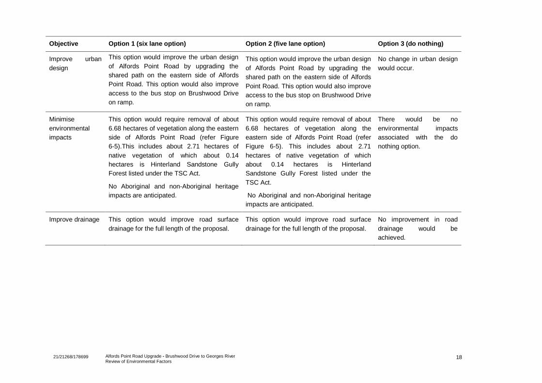
Objective Option 1 (six lane option) Option 2 (five lane option) Option 3 (do nothing)
Improve urban
design
This option would improve the urban design
of Alfords Point Road by upgrading the
shared path on the eastern side of Alfords
Point Road. This option would also improve
access to the bus stop on Brushwood Drive
on ramp.
This option would improve the urban design
of Alfords Point Road by upgrading the
shared path on the eastern side of Alfords
Point Road. This option would also improve
access to the bus stop on Brushwood Drive
on ramp.
No change in urban design
would occur.
Minimise
environmental
impacts
This option would require removal of about
6.68 hectares of vegetation along the eastern
side of Alfords Point Road (refer Figure
6-5).This includes about 2.71 hectares of
native vegetation of which about 0.14
hectares is Hinterland Sandstone Gully
Forest listed under the TSC Act.
No Aboriginal and non-Aboriginal heritage
impacts are anticipated.
This option would require removal of about
6.68 hectares of vegetation along the
eastern side of Alfords Point Road (refer
Figure 6-5). This includes about 2.71
hectares of native vegetation of which
about 0.14 hectares is Hinterland
Sandstone Gully Forest listed under the
TSC Act.
No Aboriginal and non-Aboriginal heritage
impacts are anticipated.
There would be no
environmental impacts
associated with the do
nothing option.
Improve drainage This option would improve road surface
drainage for the full length of the proposal.
This option would improve road surface
drainage for the full length of the proposal.
No improvement in road
drainage would be
achieved.
19 21/21268/178699 Alfords Point Road Upgrade - Brushwood Drive to Georges River
Review of Environmental Factors
The ‘do nothing’ option would not meet the proposal objectives and would not improve the existing
congestion experienced at the Illawong/Alfords Point off ramp and Brushwood Drive on ramp. The ‘do
nothing’ option would not reduce road crashes, improve road safety or improve travel times and therefore
was discounted.
Option 2 would remove the existing merge issue at the Brushwood Drive on ramp however, would not
address:
Southbound congestion at the merge from three lanes to two lanes directly south of Alfords Point
Bridge
Southbound congestion at the Illawong/Alfords Point off ramp
The existing safety issue associated with trucks exiting the heavy vehicle inspection bay having to
change lanes and merge at low speeds with the faster travelling traffic on Alfords Point Road.
This option was therefore discounted.
2.5 Preferred option
The preferred option selected is Option 1, which involves upgrading the existing four lane undivided road
to a six lane divided carriageway for about 2.1 kilometres between Alfords Point Bridge and Brushwood
Drive, Alfords Point. Widening would be on the eastern side of Alfords Point Road and would result in
three lanes in each direction. Providing three lanes from the Alfords Point Bridge to Brushwood Drive
would provide continuity with the three southbound lanes on the northern approach to Alfords Point
Bridge. This would remove the requirement for traffic to merge into two lanes across the bridge then back
into three lanes south of the heavy vehicle inspection bay as per Option 2. The preferred option would
best meet the objectives of the proposal by:
Reducing congestion on Alfords Point Road by removing the merge point between Brushwood Drive
on ramp and Alfords Point Road. Increasing storage capacity on Illawong/Alfords Point off ramp
would also reduce congestion on Alfords Point Road
Improving road safety by increasing sight distances and removing the merge point at Brushwood
Drive on ramp including the conflict between buses and vehicles. The concrete barrier separating the
northbound and southbound lanes would also contribute to improved road safety
Improving road safety by relocating the heavy vehicle inspection bay to a location where trucks
exiting the bay can merge more safely with through traffic
Improving safety for pedestrians/cyclists through the provision of a formal shared path including a
continuous concrete barrier separating pedestrians and cyclists from vehicles
Improving urban design through landscaping
Minimising environmental impacts such vegetation clearing
Improving the road surface drainage on Alfords Point Road.
The principles of ecologically sustainable development as defined in Schedule 2 of the NSW
Environmental Planning and Assessment Regulation 2000 and Section 3A of the Environment Protection
Biodiversity Conservation Act 1999, were taken into consideration during selection of the preferred
option. In particular the ‘integration’ principle was considered to ensure the decision-making process took
into account long-term and short-term economic, social and environmental issues.

20 21/21268/178699 Alfords Point Road Upgrade - Brushwood Drive to Georges River
Review of Environmental Factors
2.6 Design refinements
Within the preferred option, a number of design refinements were investigated and assessed against the
proposal objectives. The design refinements are discussed below.
2.6.1 Relocation of the heavy vehicle inspection bay
The preferred option includes relocating the southbound heavy vehicle inspection bay to a new location
on Alfords Point Road. When exiting the heavy vehicle inspection bay, the steep gradient south of the
existing heavy vehicle inspection bay prevents heavy vehicles from reaching a safe speed (relative to
through traffic) before merging with traffic to change lanes before the southbound off ramp. Two locations
for the heavy vehicle inspection bay were considered.
Relocate to under Brushwood Drive
This option would provide a safe exit from the heavy vehicle inspection bay either by means of a high
entry angle left turn or an acceleration lane which would involve earthworks and pavement widening
along Alfords Point Road for 700 metres. However, due to the crest being about 120 metres south of the
Illawong/Alfords Point off ramp, there would be insufficient sight distance on approach to the site for the
safe operation of the inspection bay.
This location would allow restricted access to the heavy vehicle inspection bay via fencing, gates and no
stopping signage. This location would also be visible to motorists however would require minimal
vegetation clearing. Sensitive receivers would be exposed to traffic noise as they are located at a similar
elevation to Alfords Point Road. This location is also close to Sir Thomas Mitchell Aged Care Facility
which is a sensitive noise receiver.
Relocate to under Old Illawarra Road
This location would improve safety on Alfords Point Road as it would allow vehicles exiting the heavy
vehicle inspection bay on to Alfords Point Road to accelerate on a slight down grade without the need to
change lanes.
Locating the heavy vehicle inspection bay under Old Illawarra Road would allow widening of Alfords
Point Road for the entire length of the proposal site, facilitating the six lane option and improving travel
times.
This location would allow restricted access to the heavy vehicle inspection bay via fencing, gates and no
stopping signage. Sensitive noise receivers are located at a higher elevation behind rock cuttings which
would minimise construction and operation noise impacts. This location would be visible to motorists,
however would require minimal vegetation clearing.
Assessment of heavy vehicle inspection bay locations
The heavy vehicle inspection bay locations were assessed against the objectives for the proposal. The
preferred location for the heavy vehicle inspection bay is under Old Illawarra Road as it provides better
sight distances than under Brushwood Drive and therefore would provide a better location in terms of
road safety and reduced road crashes. This location would also have a lesser impact on sensitive noise
receivers.
2.6.2 Increase capacity of the Illawong/Alfords Point off ramp
Currently, the Illawong/Alfords Point off ramp has insufficient storage capacity on the approach to the
roundabout intersection during the afternoon peak period. Queuing at the intersection can often extend
back to Alfords Point Road causing congestion and unacceptable delays for southbound motorists.
Furthermore, queues that extend onto Alfords Point Road are a safety hazard for southbound traffic.

21 21/21268/178699 Alfords Point Road Upgrade - Brushwood Drive to Georges River
Review of Environmental Factors
Do nothing
Not increasing the capacity of the Illawong/Alfords Point off ramp would not address the current
congestion issues. Traffic queues would continue to extend from the off ramp onto Alfords Point Road
during peak periods and the risk of vehicle crashes would remain. Travel times would remain unchanged
in the short-term and increase in the long-term as traffic volumes on Alfords Point Road increase.
Potential construction noise and temporary traffic delays would be avoided as no construction is
required. There would be no improvement to urban design or road drainage on Alfords Point Road.
There would be no environmental impacts.
Expand to two lanes
Expanding the Illawong/Alfords Point off ramp to two lanes would increase the storage capacity of the off
ramp and minimise the risk of queuing extending back onto Alfords Point Road. This would minimise the
incidence of road crashes. The increased capacity of the off ramp would also reduce congestion at the
off ramp exit and therefore improve travel times.
Expanding to two lanes would require total rebuild of the existing road pavement resulting in construction
noise and temporary traffic delays. Operational noise would also require mitigation at some premises
within the Sir Thomas Mitchell Aged Care Facility. About 0.17 hectares of vegetation clearing would be
required which may result in a visual impact.
New roadside drainage including the upgrade of the exiting pipes and pits would improve surface water
drainage on the off ramp.
Assessment of increasing capacity on the Illawong/Alfords Point off ramp
Increasing the capacity of the Illawong/Alfords Point off ramp was assessed against the proposal
objectives.
Increasing the capacity of the Illawong/Alfords Point off ramp by expanding it to two lanes is the preferred
design refinement. This refinement would reduce congestion at the off ramp, thereby improving travel
times and reducing the risk of road crashes. Expanding the Illawong/Alfords Point off ramp to two lanes
would also improve surface water drainage on the off ramp.
2.6.3 Relocation of the bus stop
The existing bus stop on Brushwood Drive on ramp is in a location with poor sight distances. Buses are
required to stop in the off ramp merge lane to pick up and set down passengers. This is causing
congestion, particularly during the morning peak period. Pedestrians accessing the bus stop are required
to walk for a short length on the road pavement adjacent to the off ramp merge lane.
Do nothing
The safety hazard caused by poor sight distance to the bus stop would persist if the bus stop is not
relocated. Congestion issues related to buses merging with northbound vehicles on the Brushwood Drive
on ramp would remain unchanged. The visual setting would remain unchanged. There would be no
improvement in safety for pedestrian access to the bus bay.
Relocate 90 metres north of its current location
A bus bay at this location would allow buses to stop without blocking on ramp traffic. It would also
provide safe access for pedestrians. However, there would be limited sight distance for buses exiting the
bus bay and merging with traffic travelling at the through traffic speed. Intermittent operational noise from
bus activity would be experience by nearby sensitive receivers (refer Section 6.1). About 0.05 hectares of
vegetation would require clearing.

22 21/21268/178699 Alfords Point Road Upgrade - Brushwood Drive to Georges River
Review of Environmental Factors
Relocate 80 metres south of its current location
This location would greatly increase safety for pedestrians and motorists due to improved visibility and a
slower speed environment. Relocation of the bus stop would make it easier for buses to merge with other
vehicles and would therefore reduce congestion issues. Intermittent operational noise from bus activity
would be experienced at nearby sensitive receivers. About 0.02 hectares of ornamental vegetation would
require clearing. New roadside drainage would improve surface water flow on Alfords Point Road.
Assessment of bus stop locations
Relocating the bus stop to a location 80 metres south of its current location is the preferred refinement.
This would reduce congestion on the Brushwood Drive on ramp and reduce the likelihood of vehicle
crashes. Relocating the bus stop would also improve road safety for motorists and pedestrians.