albuquerque / bernalillo comprehensive plan update and integrated development ordinance€¦ ·...
TRANSCRIPT

March 11, 2016
www.abc-zone.com
Albuquerque / BernalilloComprehensive Plan Update and
Integrated Development Ordinance

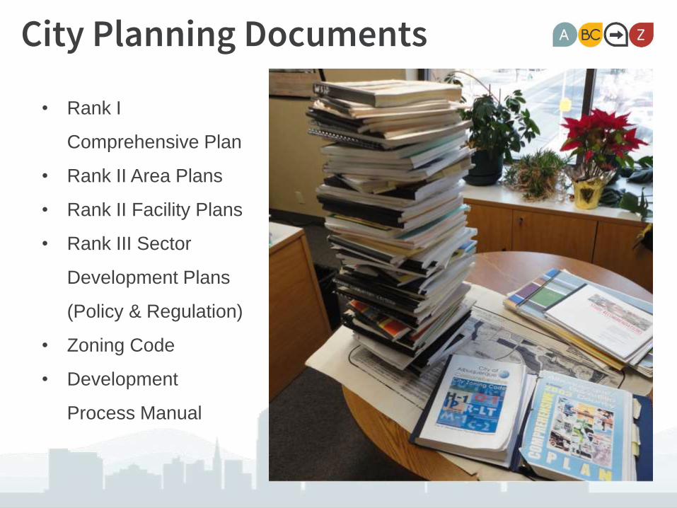
City Planning Documents
• Rank I
Comprehensive Plan
• Rank II Area Plans
• Rank II Facility Plans
• Rank III Sector
Development Plans
(Policy & Regulation)
• Zoning Code
• Development
Process Manual
1978 20141996 20051987
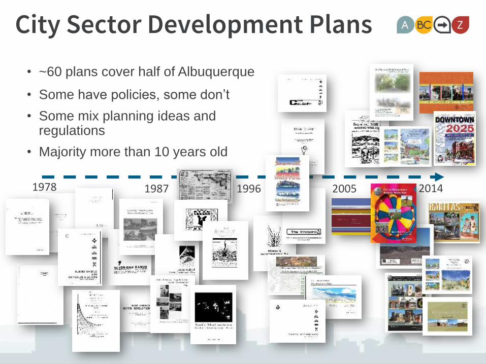
City Sector Development Plans
• ~60 plans cover half of Albuquerque
• Some have policies, some don’t
• Some mix planning ideas and regulations
• Majority more than 10 years old

Special use zones: SU-2 & SU-3Over 40 standalone Sector Development Plans
with zoningOver 235 separate zones!
• Sector Plans = Place-based but one-off solutions
• Complicated regulations & multiple layers driving away some development
• Conflicting regulations
• Inconsistent development processes
• All but impossible to enforce

Why Update?
• Anticipated growth
• New demographic trends
• Coordinating land use / transportation
• Leveraging and enhancing sense of place
0
500,000
1,000,000
1,500,000
1980 1990 2000 2010 2020 2030 2040
County
City
Future County Projections
Future City Projections
Mid-Region Council of Governments Forecast for 2040:• 311,000 new people • 132,000 new jobs

Conflicting & Overlapping Policies
7
Rank 1 Goals &Policies
Rank 2 Area PlanGoals &Policies
Rank 3City Sector Plan Goals & Policies
New Goals & Policies

What’s the update process?
Define existing
conditions
and confirm the
community
vision.
Evaluate the
community
vision for the City
& County.
Update
the ABC
Comp
Plan.
Coordinate to
create City’s new
Integrated
Development
Ordinance.
Identify
community values
and desires
through public
engagement.
21
We are here!
43 5

Date Public Engagement
Feb. 2015 Public Kickoff
May-June 2015 Community Visioning Workshops
July 2015 Focus Groups
Sept. 2015 Draft Vision Meetings
Nov./Dec. 2015 Focus Groups
Dec. 2015 County-focus Meetings
Jan. 2016 Draft Review Meetings
9

Survey• 1,115 responses
• Online in English & Spanish

Strong Neighborhoods Mobility Economic Vitality
Equity Community Health Sustainability
Guiding Principles

County – Area & Sector Development Plans

City – Community Planning Area Assessments
1978 20141996 20051987
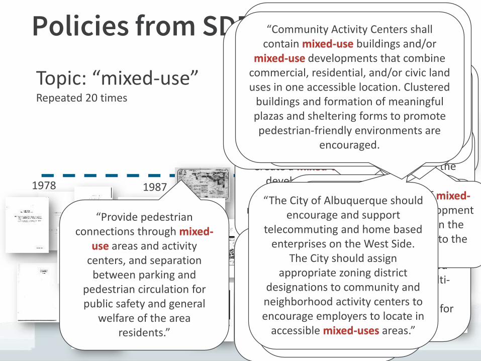
Policies from SDPs
Topic: “mixed-use”Repeated 20 times
“The City shall encourage vertical
mixed-usecommercial
development in appropriate areas of
Barelas.”“The City should discourage future
zone map amendments from
residential to mixed-use zones.
“Create a mixed-use development
integrating residential, retail and
office uses.”
“Accommodate the flow of automobile traffic through the
plan area while integrating it with a pedestrian-oriented, multi-modal, mixed-
use, urban environment.
“Develop South Yale as a healthy neighborhood which is safe, clean, and walkable with a vibrant mixed-use
economic area that promotes community ownership.”
“Provide pedestrian connections through mixed-
use areas and activity centers, and separation
between parking and pedestrian circulation for public safety and general
welfare of the area residents.”
“Creating new Mixed-useZoning that promotes
integrated, economically viable and sustainable land
uses that include: commercial, civic, office,
restaurant, hotel, housing and entertainment.
“Protecting existing neighborhoods by
maintaining the Buffer Zone protections from the 1995
USDP with regard to setbacks and height restrictions
between Uptown Mixed-Useand existing single family residential not within the
Uptown Area.”
“Establishing TIDDs that meet State, County and City laws regarding their formation in
order to promote the Uptown Area’s redevelopment as a
premiere Mixed-Use economic development area that will
benefit Albuquerque, Bernalillo County and the entire State.”
“Establish a Village Center as a mixed-use Neighborhood Activity
Center that offers a range of service, commercial, and
entertainment uses; urban housing; and some employment
opportunities.
“A village plaza or small urban park should be located near the center of the mixed-use Village Center. “
“Mixed-use development should include opportunities for retail and
services for local and nearby residents.”
“Multifamily development, public uses, educational and
institutional facilities, and commercial or employment uses
are all appropriate in the Community or Neighborhood Centers. Mixed-use and multi-
modal access shall be incorporated into the design for
these areas.”
“Support the location of mixed-uses higher density development
within this Community in the Activity Centers internal to the
Community.”
“Support the location of mixed-uses development that includes
multi-family residential developments within designated Activity Centers in the Westland
South Community.”
“Support the location of mixed-uses development that includes
multi-family residential developments within designated Activity Centers in the Rio Bravo
Community.”
“The City of Albuquerque should encourage and support
telecommuting and home based enterprises on the West Side.
The City should assign appropriate zoning district
designations to community and neighborhood activity centers to encourage employers to locate in
accessible mixed-uses areas.”
“Development of the Regional Center shall be inclusive of mixed-use, and multi-modal transportation systems. Connections to transit systems and bicycle/pedestrian linkages must be
provided with all new development. The City will continue discussion regarding location of a transit center within the
Regional Center.”
“Community Activity Centers shall contain mixed-use buildings and/or
mixed-use developments that combine commercial, residential, and/or civic land uses in one accessible location. Clustered
buildings and formation of meaningful plazas and sheltering forms to promote pedestrian-friendly environments are
encouraged.

Example: Heritage Conservation
POLICY
ACTIONS
FOOTNOTES

Policy Matrix
Policy reference number
Where policy is located in its plan of origin

Neighborhoods:Community Planning Areas

Neighborhoods:City Assessments
• Character
• Platting
• Mix of uses
• Scale: Size / massing / height
• Historic designation
• Trends
• Performance Tracking / Metrics
• Recommendations
• Policy
• Regulation
• Implementation


Open Space Network

Other Jurisdictions

Downtown
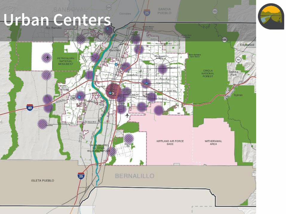
Urban Centers

Neighborhood Centers

Village Centers

Main Streets
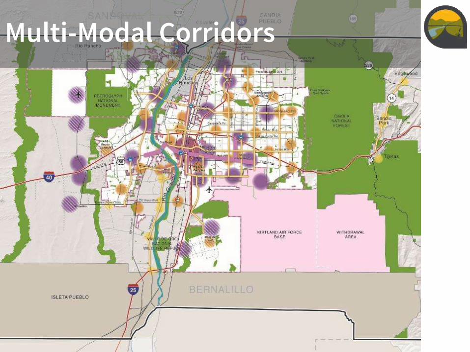
Multi-Modal Corridors

Commuter Corridors
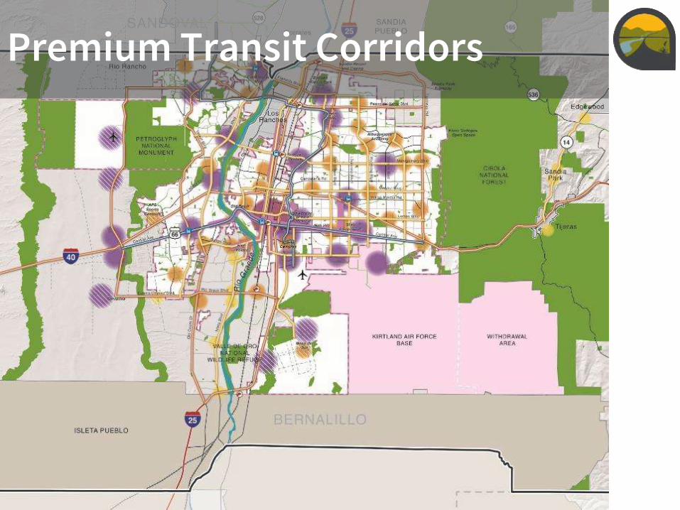
Premium Transit Corridors

Community Vision

Community Vision
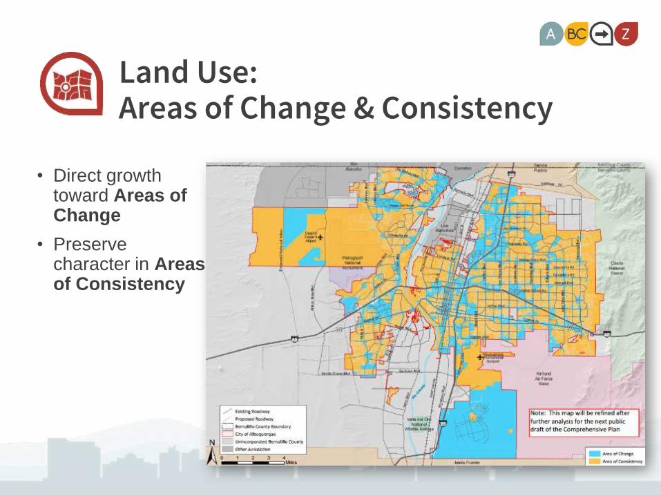
Land Use:Areas of Change & Consistency
• Direct growth toward Areas of Change
• Preserve character in Areas of Consistency
Image: Map of Areas of Consistency and Change
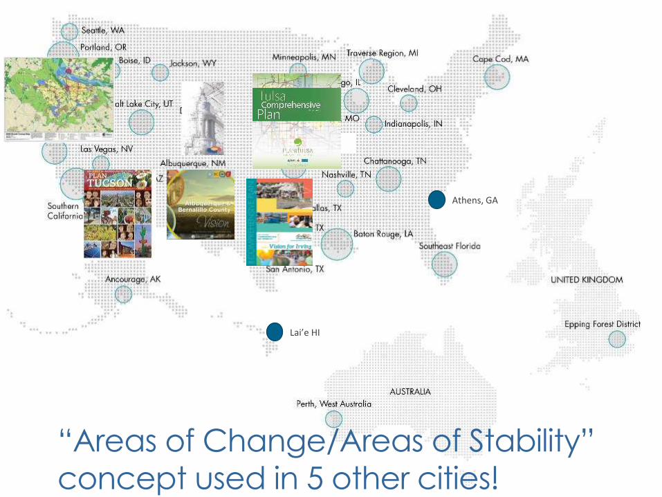
“Areas of Change/Areas of Stability”
concept used in 5 other cities!
Athens, GA
Lai’e HI
Southern Oregon
Tulsa, OK
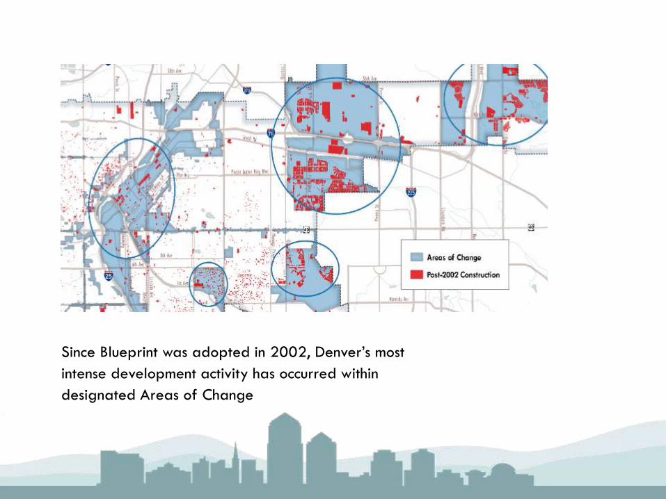
Since Blueprint was adopted in 2002, Denver’s most
intense development activity has occurred within
designated Areas of Change

Urban Design:Design Types
Auto Oriented Pedestrian Oriented

Urban Design:Coordinating land use & transportation
Activity Centers Corridors
Village Neighbor-hood
Urban Down-town
MainStreet
Multi-Modal
Transit Commuter
Des
ign
Typ
e
1 Rural
2 Suburban
3 General Urban
4 Centers & Main Streets
5 Urban Core

ABC Comp Plan• Introduction & How-to Use
• Growth & Development
• Vision – A People’s Summary
• Comp Plan Elements
• Implementation [pending]
• 5-year strategic plan for City & County
• Long-term & medium-term actions
• Coordination with outside agencies and/or organizations
Challenges / strategiesGoalsPolicies

Comp Plan Elements
1. Neighborhoods
2. Land Use
3. Transportation
4. Urban Design
5. Economic Development
6. Housing
7. Parks & Open Space
8. Heritage Conservation
9. Resilience & Sustainability
10. Infrastructure, Community Facilities, & Services


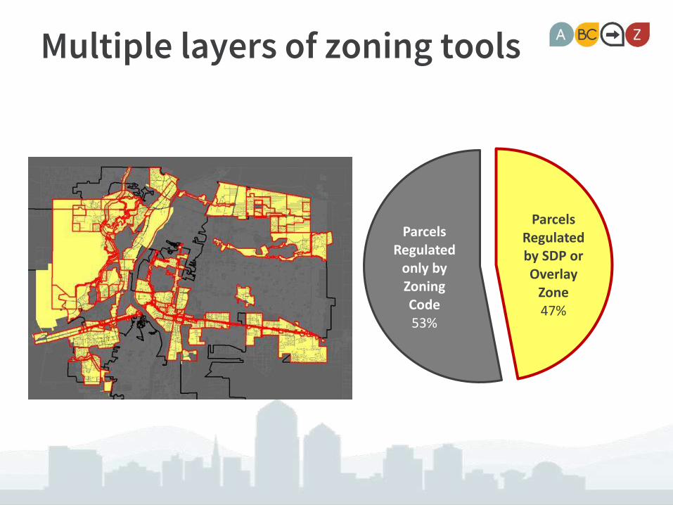
Multiple layers of zoning tools
ParcelsRegulated by SDP or Overlay
Zone47%
ParcelsRegulated
only byZoning Code53%

Special use zones: SU-1
45
Over 550 separate zones!

Conflicting and Overlapping Zoning
46
Rank 1 Goals &Policies
Rank 2 Area PlanGoals &Policies
Rank 3City Sector Plan Goals & Policies
New Goals & Policies

What happens to SU-2 Zones?
47
Base Zones
Character
Overlay Zone
Incentives
Deleted
SU-2 ZONES
Extends SU-2 zones
to other areas with
similar character
Applies protections in
unique areas
Achieves results not
wisely/legally gained
through zoning
Removes outdated or
unenforceable
regulations
City-wide
Standards
Become citywide or
areawide standards

Module 12. Permitted Uses
48
40 SU2s with Zoning
Many with 5-10 subareas
= 235+ different zone districts (+550 SU1 districts)
This table continues for 115 pages
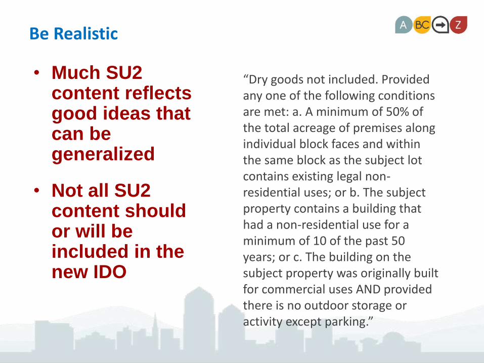
Be Realistic
• Much SU2 content reflects good ideas that can be generalized
• Not all SU2 content should or will be included in the new IDO
“Dry goods not included. Provided any one of the following conditions are met: a. A minimum of 50% of the total acreage of premises along individual block faces and within the same block as the subject lot contains existing legal non-residential uses; or b. The subject property contains a building that had a non-residential use for a minimum of 10 of the past 50 years; or c. The building on the subject property was originally built for commercial uses AND provided there is no outdoor storage or activity except parking.”

The IDO Strategy
IDO is drafted in 3 “Modules”
1. Zone Districts and Permitted/Conditional Uses
2. Development Standards
3. Administration and Procedures
Then a Consolidated Draft to EPC for review

A Simpler Permitted Use Table
51
Land uses organized by type
Zone districts in 3 categories
Use-SpecificStandards
PCCACVAT uses

Consolidate the Use-Specific Standards
Special standards that apply to a particular use that can regulate
• Scale
• Location
• Protection of adjacent land uses
• Etc.
AND
• Can be tailored to specific locations if needed
52
ExampleVeterinary Hospital
• In the MX-L and MX-M zone districts treatment of large animals, including but not limited to cattle, horses, sheep, goats, or pigs weighing over 100 pounds, is not allowed. Only treatment of dogs, cats, other domestic pets, and small animals is allowed.
• In the MX-M and NR-C zone districts outside exercise runs are permitted, provided they are enclosed with a solid wall or fence at least six feet high. Outside areas for occupancy by animals overnight are not permitted.

The Process
53
Read the SU2s and identify use controls
Save height, size, and other SU2 regulations
for consideration in Modules 2 and 3
Module 1 Text
Make good general standards into Use-
specific Standards for that use
Do not carry over lot-specific, outdated, or
unenforceable provisions
Conversion Table and Map
Identify the NEW zoning district most
similar to the intended character of
the area
Draft zone district conversion table
(Done) and conversion map (In
process)
Questions?Manager – Urban Design & Development
Planning Dept.
Long-range Planner – Planning Dept.
Policy Analyst – Council Services
Project Planner – Bernalillo County Planning
Project Webpage:
https://abc-zone.com
54