alberta wetland system - capf.ca draft requesting public feedback.pdf · alberta wetland...
TRANSCRIPT
Alberta Wetland Classification System
Alberta Wetland Classification System
April 5 2014 Alberta Wetland Classification System - DRAFT
© 2014 Government of Alberta
Page i of xiii
ISBN: (Printed) ISBN: (Online) ESRD, Water Quality, 2014, No. # Citation: Alberta Environment & Sustainable Resource Development (ESRD). 2014. Alberta Wetland Classification Sysytem. Water Policy Branch, Policy Division. Edmonton. 38 pp. Any comments, questions, or suggestions regarding the content of this document may be directed to: Water Policy Branch Alberta Environment and Sustainable Resource Development 7th Floor, Oxbridge Place 9820 – 106th Street Edmonton, Alberta T5K 2J6 Phone: (780) 427‐6278 Fax: (780) 422‐6712 Email: AENV‐[email protected] Additional copies of this document may be obtained by contacting: Alberta Environment and Sustainable Resource Development Information Centre Main Floor, Great West Life Building 9920 108 Street Edmonton Alberta Canada T5K 2M4 Call Toll Free Alberta: 310‐ESRD (3773) Toll Free: 1‐877‐944‐0313 Fax: 780‐427‐4407 Email: ESRD.Info‐[email protected] Website: http://esrd.alberta.ca
Alberta Wetland Classification System
April 5 2014 Alberta Wetland Classification System - DRAFT
© 2014 Government of Alberta
Page ii of xiii
TABLE OF CONTENTS
LIST OF TABLES .................................................................................................................................................. III
LIST OF FIGURES ................................................................................................................................................ III
ABBREVIATIONS ................................................................................................................................................ IV
GLOSSARY .......................................................................................................................................................... V
1. INTRODUCTION .......................................................................................................................................... 1
1.1 OVERVIEW ........................................................................................................................................................ 1 1.2 EXISTING WETLAND CLASSIFICATION SYSTEMS AND INVENTORIES IN ALBERTA ................................................................ 1 1.3 THE ALBERTA WETLAND CLASSIFICATION SYSTEM ..................................................................................................... 2 1.4 ALBERTA WETLAND CLASSIFICATION SYSTEM OBJECTIVES ........................................................................................... 2 1.5 WETLAND FACTORS, PROCESSES AND CHARACTERISTICS ............................................................................................. 3 1.5.1 Peat Accumulation ................................................................................................................................. 3 1.5.2 Water Regime ........................................................................................................................................ 4 1.5.3 Chemical Gradients ................................................................................................................................ 4 1.5.4 Soil Characteristics ................................................................................................................................. 5 1.5.5 Vegetation Structure and Composition .................................................................................................. 8
1.6 WETLAND DISTRIBUTION...................................................................................................................................... 9 1.7 TAXONOMY ....................................................................................................................................................... 9
2. KEY TO THE WETLAND CLASSES AND FORMS OF ALBERTA .......................................................................... 11
3. BOGS ......................................................................................................................................................... 13
3.1 WOODED BOGS ............................................................................................................................................... 13 3.2 SHRUBBY BOGS ................................................................................................................................................ 13 3.3 BOG TYPES ...................................................................................................................................................... 14
4. FENS .......................................................................................................................................................... 14
4.1 WOODED FENS ................................................................................................................................................ 14 4.2 SHRUBBY FENS ................................................................................................................................................. 14 4.3 GRAMINOID FENS ............................................................................................................................................. 15 4.4 FEN TYPES ....................................................................................................................................................... 15
5. MARSHES AND SHALLOW OPEN WATERS ................................................................................................... 18
5.1 MARSHES ........................................................................................................................................................ 18 5.2 SHALLOW OPEN WATERS ................................................................................................................................... 18 5.3 MARSH AND SHALLOW OPEN WATER TYPES .......................................................................................................... 18 5.3.1 Temporary marshes ............................................................................................................................. 20 5.3.2 Seasonal marshes ................................................................................................................................ 21 5.3.3 Semi‐permanent marshes .................................................................................................................... 23 5.3.4 Seasonal shallow open waters ............................................................................................................. 24 5.3.5 Semi‐permanent shallow open waters ................................................................................................ 26 5.3.6 Permanent shallow open waters ......................................................................................................... 28 5.3.7 Intermittent shallow open waters........................................................................................................ 29
6. SWAMPS ................................................................................................................................................... 30
6.1 CONIFEROUS WOODED SWAMPS ......................................................................................................................... 30 6.2 MIXEDWOOD WOODED SWAMPS ........................................................................................................................ 30 6.3 DECIDUOUS WOODED SWAMPS .......................................................................................................................... 31
Alberta Wetland Classification System
April 5 2014 Alberta Wetland Classification System - DRAFT
© 2014 Government of Alberta
Page iii of xiii
6.4 SHRUBBY SWAMPS ........................................................................................................................................... 31 6.5 SWAMP TYPES ................................................................................................................................................. 31
7. LITERATURE CITED ..................................................................................................................................... 34
COMPARING THE ALBERTA WETLAND CLASSIFICATION SYSTEM TO OTHER WETLAND APPENDIX ACLASSIFICATIONS AND INVENTORIES .................................................................................................................. 1
VON POST DECOMPOSITION SCALE .......................................................................................... 1 APPENDIX B
PRELIMINARY PROVINCIAL LIST OF WETLAND PLANT SPECIES ................................................... 1 APPENDIX C
LIST OF TABLES
Table 1. Salinity types and corresponding conductivity ranges .............................................................. 5
Table 2. Wetland classes, forms and types in the Alberta Wetland Classification System. ................ 10
Table 3. Description of hydroperiod types for marshes and shallow open waters. ............................. 19
Table 4. Salinity range types of marsh and shallow open waters in relation to hydroperiod types. ... 20
LIST OF FIGURES
Figure 1. Example of soil mottling in a wetland. ...................................................................................... 7
Alberta Wetland Classification System
April 5 2014 Alberta Wetland Classification System - DRAFT
© 2014 Government of Alberta
Page iv of xiii
ABBREVIATIONS
ACIMS Alberta Conservation Information Management System
AWCS Alberta Wetland Classification System
AWI Alberta Wetland Inventory
CWCS Canadian Wetland Classification System
ITIS International Taxonomic Information System
µS/cm microSiemens per centimetre
Alberta Wetland Classification System
April 5 2014 Alberta Wetland Classification System - DRAFT
© 2014 Government of Alberta
Page v of xiii
GLOSSARY
acidic – refers to soil or water with low concentrations of base cations (e.g., potassium, magnesium, calcium) and a pH of less than 7; soil or water is slightly acidic if it has a pH of 5.5 to 6.5, moderately acidic if the pH is 4.5 to 5.5, and acidic if the pH is less than 4.5
aerobic – pertaining to the presence of oxygen
alkaline – soil or water with a pH greater than 7.4
alkaline wetland – Specifically refers to saline shallow open water wetlands with an electrical conductivity of > 45,000 µS/cm
alkalinity – the capacity of an aqueous solution to neutralize an acid
alluvial fan – a fan‐ or cone‐shaped deposit of sediment crossed and built up by streams
anaerobic – pertaining to the absence of oxygen
anthropogenic disturbance – a change in environmental conditions caused by human activity
biogeochemical – relationships between chemical changes in the earth’s crust and living organisms
biotic – having to do with living organisms
bog – a treed or shrubby peatland fed exclusively by precipitation, with no surface or subsurface inflow, acidic waters and low available nutrients
brown moss – a group of peat‐forming mosses of several genera (e.g., Scorpidium, Drepanocladus, Calliergon, Campylium, Hypnum, Tomenthypnum) that are often abundant and can comprise a high proportion of the ground cover in some fens (see Section 5.0)
brackish – water with moderate to high concentrations of dissolved salts and other dissolved solids; electrical conductivity typically ranges from 5,000 µS/cm to 15,000 µS/cm
bryophyte – a group of non‐vascular plants including the mosses, liverworts and hornworts
canopy – the leaves and branches of trees or shrubs in the uppermost layer (stratum) of a wooded or shrubby ecosystem
ecosystem/wetland complex – an area encompassing two or more distinguishable ecosystems; wetland complexes include more than one class of wetland (e.g., areas of bog with small fen areas)
conductivity – the ability of a substance to conduct electricity, measured in microsemens per centimeter (µS/cm). Measurements can be converted into Total Dissolved Solids (TDS) and vise versa using available published tables

Alberta Wetland Classification System
April 5 2014 Alberta Wetland Classification System - DRAFT
© 2014 Government of Alberta
Page vi of xiii
coniferous – refers to cone‐bearing trees with needle‐like leaves; in Alberta wetlands, coniferous usually refers to black spruce (Picea mariana mariana), white spruce (Picea glauca) or tamarack (Larix laricina)
deciduous – a tree that sheds its leaves annually. In Alberta wetlands, deciduous often refers to Alaska birch (Betula neoalaskana), white birch (Betula papyrifera) and several cottonwood and poplar species, including balsam poplar (Populus balsamifera), plains cottonwood (Populus deltoids) and narrow‐leaf cottonwood (Populus angustifolia).
deep wetland community – a wetland plant community that comprises robust, emergent graminoids that are tolerant of water levels of approximately up to 1 m in depth. This community is found in the deepest portion of semi‐permanent mineral wetlands or on the fringe of permanent mineral wetlands
delta – a landform found at the mouth of a river where a river flows into another waterbody
discharge – pertaining to wetlands that receive water from groundwater flow
emergent – pertains to graminoid plants such as cattails, rushes and sedges that dominate a deep marsh community and can tolerate variable flooding
ephemeral waterbody – an upland area that can be saturated or hold water for a short period of time, typically contains a mixture of upland and water‐tolerant plant species. Species typically present include Canada anemone (Anemone canadensis), Kentucky bluegrass (Poa pratensis) and slender wheatgrass (Elymus trachycaulus), provided the area has not been tilled for agricultural use. Crops are usually present if the area has been tilled, although these might not be as robust as those on higher ground. Gleys and mottles, if present, are typically found 30 cm or more below the surface
ericaceous – belonging to the Heather family, Ericaceae; ericaceous shrubs include species such as bog rosemary (Andromeda polifolia), common Labrador tea (Rhododendron groenlandicum), leatherleaf (Chamaedaphne calyculata) and northern laurel (Kalmia polifolia)
extreme‐rich fen – a fen with a high number of indicator species and a pH greater than 7.0
feathermoss – a group of large, regularly branched mosses with stalks that often resemble feathers. Examples are stair‐step moss (Hylocomium. splendens), big red stem moss (Pleurozium schreberi) and knight’s‐plume moss (Ptilium crista‐castrensis)
fen – a minerogenous peatland, usually with some surface or subsurface water flow, that can have wooded, shrubby and graminoid forms, with pH ranges from moderately‐acidic to alkaline
fibrisol – a type of organic soil with relatively undecomposed (i.e., fibric) organic material
flark – wet depressions between peat ridges (strings) in patterned fens; always oriented perpendicular to the direction of water flow
forb – a non‐graminoid, non‐woody vascular plant that is usually broad‐leaved
Alberta Wetland Classification System
April 5 2014 Alberta Wetland Classification System - DRAFT
© 2014 Government of Alberta
Page vii of xiii
freshwater – water with very low concentrations of dissolved salts and other dissolved solids; electrical conductivity is less than 500 µS/cm
glaciofluvial – associated with flowing watercourses that come in contact with glaciers. Glaciofluvial watercourses typically carry large amounts of gravel and sand
graminoid – an erect, rooted and herbaceous grass‐like plant; includes grasses, sedges, rushes, arrow‐grasses, and cattails
gleying – blue‐grey or greenish soil that results from reduction of iron and manganese compounds caused by prolonged saturation
gleysolic soil – soil developed from prolonged intermittent or permanent soil saturation and characterized by blue‐grey or greenish colours through the soil mass or in prominent orange mottles (spots or streaks)
graminoid – grass‐like vegetation; refers primarily to plants in the sedge family (Cyperaceae), grass family (Poaceae) or rush family (Juncaceae)
ground cover – all components of the land surface, including low vascular plants (less than 30 cm tall), bryophytes, lichens, organic debris (leaves, wood, peat), exposed surface (rock, soil) and water
groundwater – subsurface water moving in soil and underlying strata
growing season – period of each year when climatic conditions are favourable for plant growth
herb (herbaceous adj.) – a vascular plant with no persistent wood stems above the ground, including pteridophytes (e.g. ferns, horsetails), graminoids and forbs
humisol – a type of organic soil with advanced decomposition of organic materials; most of these materials are humified with few recognizable fibers
hummock – a small mound, usually composed of peat moss or clumps of graminoids
hydric – soil that is saturated long enough during the growing season to develop anaerobic conditions in the rooting zone
hydrologic – pertaining to atmospheric, surface and subsurface water
hydroperiod – the length of time the water table is at or above the surface of a wetland
hydrophyte (hydrophytic adj.) – a plant that preferentially grows in wet areas under continuous or periodic anaerobic conditions
indicator species – an organism that defines a trait or characteristic of the environment
intermittent – pertaining to periodical saturation of surface and soil
Alberta Wetland Classification System
April 5 2014 Alberta Wetland Classification System - DRAFT
© 2014 Government of Alberta
Page viii of xiii
lentic – an ecosystem associated with standing water
lichen – a group of complex organisms in which a fungus and an alga grow together in a mutually beneficial (symbiotic) relationship
liverwort – any of the plants of the class Hepaticae in the division Bryophyta, usually with small, leafy stems but some species have a flat, tongue‐ to ribbon‐like body without leaves (a thallus)
lotic – an ecosystem associated with flowing water
marl – a soft, unconsolidated deposit consisting of calcium carbonate or magnesium carbonate, and often indicated by the accumulation of shells
marsh – a mineral wetland with water levels near, at or above the ground surface for variable periods during the year, and which supports graminoid vegetation in the deepest portion of the wetland in the majority of years
mesisol – a type of organic soil with moderately decomposed organic material which does not meet the requirements of either a fibric or a humic layer
mineral soil – soil consisting predominantly of, and with most properties determined by, mineral matter; contains less than 17% organic carbon, except for an organic surface layer that may be up to 40 cm thick. Soils have a von Post degree of decomposition of greater than 5
mineral wetland – a wetland characterized by mineral soils. If peat is present, it is less than 40 cm deep
minerogenous – a wetland that receives water from precipitation as well as groundwater and/or surface water that has accumulated minerals from soil and/or bedrock
mixedwood– a wooded wetland consisting of a mix of coniferous and deciduous species
moderate‐rich fen – a fen with a moderate number of indicator species and a pH between 5.5 and 7.0
moderately brackish water – water with moderate concentrations of dissolved salts and other dissolved solids; electrical conductivity ranges from 2,000 µS/cm to 5,000 µS/cm
moss – non‐vascular plants of the class Musci in the division Bryophyta, that have small, leafy stems with inconspicuous sex organs that produce sporophytes
mottles – spots or blotches of different colour or shades of colour interspersed throughout the soil; often orange in wet, iron‐rich soils that are only occasionally exposed to oxygen. Mottles are characteristic of Gleysolic soils and when present in the rooting zone of plants (i.e., up to 30 cm in depth) are characteristic of mineral wetlands
non‐vascular plant – a plant without a vascular system (i.e., xylem and phloem), including mosses, liverworts and hornworts

Alberta Wetland Classification System
April 5 2014 Alberta Wetland Classification System - DRAFT
© 2014 Government of Alberta
Page ix of xiii
non‐native species – an introduced species that was not present in the environment prior to European colonization, or that does not naturally occur in an area
ombrogenous – a wetland that receives surface water solely from precipitation
open water – an expanse of open, mostly unshaded water that either supports submersed or floating vegetation or is devoid of vegetation
organic soil – soil developed mainly from organic deposits, containing at least 17% organic carbon (roughly equivalent to at least 35% organic matter); organic soils are usually saturated for most of the year, unless they are artificially drained.
patterned fen – a fen with alternating ridges of peat (strings) and shallow pools (flarks) that form sinuous or netted patterns and that are oriented perpendicular to the direction of water flow
peat – ground made of partially decomposed plant material that accumulates under saturated conditions; peat accumulation defines peatlands from mineral wetlands with organic and/or mineral soils
peatland – wetland with more than 40 cm of accumulated peat; includes bogs and fens
permafrost – perennially frozen ground (including rock or soil) that remains at or below 0˚C for more than a year
permanent – describes the hyrdoperiod of a shallow open water wetland that is flooded continuously even in persistent drought conditions; this type of wetland typically contains submersed and/or floating aquatic vegetation in the deepest portion of the wetland in the majority of years, or is devoid of vegetation in the open water zone
poor fen – a fen with a low number of indicator species and a pH of 5.5 or less
pteridophyte – a vascular plant with roots, stems and leaves, and reproducing by spores (no flowers or fruits); examples include ferns and horsetails
recharge – pertaining to the infilitration of water through soils, adding water to groundwater supplies
rooting zone – the depth to which the roots of most herbaceous plant extend past is roughly 30 cm
saline water – water with very high concentrations of dissolved salts and other dissolved solids; measured by proxy by electrical conductivity greater than 45,000 µS/cm
saltflat – intermittently flooded mineral surfaces where salts are concentrated by evaporation during dry periods, and may appear as whitish crystals
seasonal – describes the hydroperiod of a mineral wetland that is typically flooded for most of the growing season, but has little or no surface water remaining by the end of the summer; this type of

Alberta Wetland Classification System
April 5 2014 Alberta Wetland Classification System - DRAFT
© 2014 Government of Alberta
Page x of xiii
wetland typically contains shallow wetland vegetation in the deepest portion of the wetland in the majority of years
semi‐permanent – describes the hydroperiod of a mineral wetland that is typically flooded year‐round, except in years when drought conditions persist; this type of wetland typically contains deep wetland vegetation in the deepest portion of the wetland in the majority of years
shallow open water – a wetland that is less than 2 m deep at midsummer, and that supports submersed or floating vegetation in the deepest portion of the wetland in the majority of years, or is devoid of vegetation
shallow wetland community – a wetland vegetation community found in some marshes and shallow water wetlands that is an indicator of a seasonal hydroperiod; dominant forms are graminoids, such as sedges and grasses that typically tolerate soil saturation and shallow inundation
shrub – a woody, multi‐stemmed plant or tree that is no taller than 3 m
slightly brackish – water with low concentrations of dissolved salts and other dissolved solids; measured by proxy by electrical conductivity ranges between 500 µS/cm and 2,000 µS/cm
string – ridge of peat, elevated above the surface water and oriented perpendicular to the direction of water flow in patterned fens
submersed and floating aquatic plants – plants that occupy open water up to a maximum depth of 2 meters. Species rooted in the substrate may be entirely submersed or have floating leaves and flowering structures; other species are free‐floating in the water column without anchorage to the substrate
subsaline water – water with high concentrations of dissolved salts and other dissolved solids; measured by proxy by electrical conductivity ranges between 15,000 µS/cm and 45,000 µS/cm
swamp – a mineral wetland with water levels near, at or above the ground surface for variable periods during the year and either more than 5% tree cover of a variety of species or at least 25% shrub cover
temporary – describes the hydroperiod of a mineral wetland that is typically flooded every year for a short period of time after snowmelt or a heavy rainfall, but otherwise lacks surface water; this type of wetland contains wet meadow vegetation in the deepest portion of the wetland in the majority of years
tilled – the process of digging, stirring or overturning soil for agricultural purposes
tree – a woody, single stemmed plant that is 3 m or greater in height
understory – the lower layer of tall plants in vertically stratified vegetation; usually refers to shrubs below the canopy of trees, but can also apply to graminoids and forbs
Alberta Wetland Classification System
April 5 2014 Alberta Wetland Classification System - DRAFT
© 2014 Government of Alberta
Page xi of xiii
upland – terrain not affected by high water table or excess surface water, or affected only for short periods (e.g., ephemeral waterbody). Evidence of wet soil processes may be found 30 cm below the ground surface or may not be present. Upland vegetation species dominate, although they may be intermixed with water‐tolerant species.
vascular plants – plants with lignified tissues (i.e., xylem and phloem) used for conducting water and nutrients through the plant
von Post decomposition scale – a field test to determine the degree of organic matter decomposition in the ground layer; the test involves squeezing the organic matter and observing the nature of the liquid released, the amount of organic material that remains, and the characteristics of the organic matter
water table – the level at which ground water pressure equals atmospheric pressure; the upper surface of groundwater above which the soil can be aerated and below which the soil is saturated
wetland – land that is saturated with water long enough to promote formation of water altered soils, growth of water tolerant vegetation, and various kinds of biological activity that are adapted to wet environments
wet meadow community – wetland vegetation community found in some marshes and shallow water wetlands that is an indicator of a temporary hydroperiod; graminoid, forb and shrub species in this community can tolerate saturated soils and withstand short periods of shallow inundation
wooded – a wetland that contains more than 5% tree cover

April 5 2014 Alberta Wetland Classification System – DRAFT
© 2014 Government of Alberta
1
1. INTRODUCTION
1.1 OVERVIEW
Wetlands are land saturated with water long enough to promote formation of water altered soils,
growth of water tolerant vegetation, and various kinds of biological activity that are adapted to a wet
environment. Wetlands are highly diverse, productive ecosystems that provide a host of ecological
services and form an important component of Alberta’s diverse landscapes. Alberta is home to a rich
and varied array of wetland classes, including bogs, fens, marshes, shallow open waters and swamps.
Approximately 20% of Alberta’s surface area is covered by wetlands, 90% of which are peatlands.
Wetlands provide many ecological benefits to Albertans. They provide flood mitigation by storing and
slowly releasing large volumes of water. They function as natural purification systems, cleansing surface
waters and improving water quality. Some wetlands act as a conduit between above‐ and below‐ground
water tables, recharging local and regional groundwater aquifers. Wetlands support a rich array of
biodiversity; in Alberta alone, it is estimated that wetlands are home to more than 600 species of plants,
some of which are provincially listed as rare, threatened, or endangered. Collectively, wetlands provide
important habitat for several hundred vertebrate species, including vast populations of migratory
waterfowl. Wetlands in Alberta provide crucial habitat for several threatened and endangered species,
such as the northern leopard frog, piping plover, trumpeter swan, whooping crane, and woodland
caribou.
Alberta’s wetlands also support a wide variety of human activities. They are used for recreational
pursuits (e.g., bird watching, hunting) and have increasingly become a focal point for the ecotourism
industry. They are a highly valued resource to First Nations and Métis communities, for whom they
provide many cultural and traditional uses. Wetlands are also very important to Alberta’s agriculture
and forestry sectors and play a significant role in wildlife conservation programs. A specialized peat
harvesting industry in the province extracts peat for the horticultural market.
1.2 EXISTING WETLAND CLASSIFICATION SYSTEMS AND INVENTORIES IN ALBERTA
Wetland classification in Alberta has previously relied on at least four different classification systems.
The Canadian Wetland Classification System (CWCS, National Wetlands Working Group 1997), which
was developed to support wetland classification at a national scale, has been extensively used in
Alberta, particularly in the central and northern parts of the province where peatlands are more
prevalent. The Stewart and Kantrud Classification System (Stewart and Kantrud 1971) is widely used in
southern half of Alberta to classify wetlands in the prairies. The Cowardin Wetland Classification System
(Cowardin et al. 1979) and the Field Guides to Ecosites of Alberta (Beckingham 1996; Beckingham and
Archibald 1996) are also used in Alberta.
Several wetland inventories are also currently used in Alberta. The Ducks Unlimited Boreal Plains
Ecozone Classification (Smith et al. 1997) and the Alberta Wetland Inventory (AWI, Halsey et al. 2003)
have been used extensively in the Boreal Region. In southern Alberta, the Grassland Vegetation
Inventory includes the identification of lentic ecosystems and has been incorporated into the Alberta
CWCS Merged Wetland Inventory for the province, along with the Ducks Unlimited inventory (Alberta
Environment and Sustainable Resource Development 2013).

April 5 2014 Alberta Wetland Classification System – DRAFT
© 2014 Government of Alberta
2
A provincially consistent system for classifying wetlands is necessary to enhance education, scientific
knowledge and information, and regulatory management of wetlands. Moreover, existing classification
systems lack regional relevance, in that they do not characterize wetlands specific to Alberta’s provincial
flora, soils, and other characteristics. To reconcile these differences, the Alberta Wetland Classification
System (AWCS) has been developed for use and application across the province.
For a comparison of the AWCS with other classification systems and inventories used in the province,
see Appendix A.
1.3 THE ALBERTA WETLAND CLASSIFICATION SYSTEM
The Alberta Wetland Classification System recognizes the hydrological, biogeochemical and biotic
processes that affect differing characteristics that can be used to define a wetland. The AWCS recognizes
five classes of wetlands in Alberta: bogs, fens, marshes, shallow open water, and swamps. These five
classes align with the CWCS at its most basic level and are recognized by the Alberta Wetland Policy.
In the AWCS, wetland classes are divided into forms based on vegetation structure. This subclassification
can be used to align wetland classification with the Ducks Unlimited and AWI inventories as well as the
Field Guides to Ecosites of Alberta. It also recognizes the importance that vegetation structure has on
wetland processes and biodiversity (i.e., wooded – coniferous, – mixedwood, – deciduous; shrubby;
graminoid; and aquatic). Some wetland classes have a unique wetland form, whereas others may have
multiple wetland forms (i.e. graminoid, shrubby or treed fens).
Wetland forms are further subdivided into types based on the length of time that surface water is at or
above the surface, or its hydroperiod, along with basic water characteristics such as acidity and salinity.
Stewart and Kantrud classes for prairie wetlands are captured at this level. Identifying a wetland to its
type may be important for conserving or replacing unique ecosystems, habitats, and their associated
organisms and communities. Some wetland classes and forms have unique wetland types; others
include multiple wetland types.
1.4 ALBERTA WETLAND CLASSIFICATION SYSTEM OBJECTIVES
The AWCS merges information from existing wetland classification systems to provide a holistic
classification system for the province. The AWCS is tailored specifically to Alberta, and provides key
indicator species for characterizing wetlands. Overall, the AWCS aims to provide a standardized
provincial wetland classification system that:
Promotes a broader understanding of wetlands ecosystems
Applies classification keys that are associated with wetland hydrologic, biogeochemical and biotic
processes
Is compatible with existing wetland classification systems and inventories, as well as legislation and
policies that may affect wetlands
Can be applied to Canadian geographic information system (GIS) databases
Is useful and readily applicable for wetland identification, mapping and environmental assessment

April 5 2014 Alberta Wetland Classification System – DRAFT
© 2014 Government of Alberta
3
1.5 WETLAND FACTORS, PROCESSES AND CHARACTERISTICS
Wetlands are an integral part of the landscape in which they occur. Regional factors that affect wetlands
include climate, landscape situation and context, and surface and subsurface geology. These factors
influence the following ecological processes:
Hydrologic processes, such as the capacity of a wetland to receive, store, moderate and release
surface water and groundwater in a watershed
Biogeochemical processes, such as acid–base reactions, ion exchange, oxidation–reduction
reactions, decomposition, nutrient cycling and carbon accumulation
Biotic processes, such as biological productivity and competition
Recognizing the complexity of these hydrological, biogeochemical and biotic processes and their effect
on wetlands, the AWCS uses wetland characteristics that reflect these processes to help identify
wetland classes, forms and types. These characteristics include:
Peat accumulation (Section 1.5.1)
Water regime, including sources, water levels and hydroperiod (Section 1.5.2)
Chemical gradients in the water (Section 1.5.3)
Soil characteristics (Section 1.5.4)
Vegetation structure and composition (Section 1.5.5)
The AWCS provides the necessary classification keys and descriptors to distinguish between wetlands
and uplands, and among differing wetland classes, forms and types. In some cases, wetlands might not
fit into a discrete class, but instead will display intermediary characteristics between classes (e.g.,
intermediate states between marshes and fens). Additional characteristics of a wetland might help
determine how best to classify it; however, the importance of one characteristic over another must be
carefully weighed and evaluated.
It is important to consider natural and anthropogenic disturbances in wetlands during classification.
When a disturbance to a wetland has occurred, whether it occurred due to natural (e.g., beaver dam,
fire, drought) or anthropogenic (e.g., impoundment) reasons, wetland characteristics may deviate under
these new conditions. In such cases, poor plant health, abnormal assemblages of species, or
combinations of other atypical wetland characteristics might indicate that the wetland has undergone a
recent disturbance. For instance, marshes and shallow open water wetlands are exposed to natural
fluctuating water levels and hydroperiods that can shift plant community structure and composition. It is
important to take climate andlandscape factors into careful consideration when attempting to classify
wetlands.
1.5.1 Peat Accumulation
Wetlands are divided into two broad groups: peatlands and mineral wetlands. For the purposes of this
classification system, bogs and fens are considered to be peatlands and all other wetland classes
(swamps, marshes and shallow open water) are considered to be mineral wetlands. The presence and
depth of peat is the sole diagnostic characteristic that differentiates peatlands from mineral wetlands.
Peat can be composed of a wide range of unconsolidated or partially decomposed organic materials,
including bryophytes, herbaceous vascular plants and woody debris. For a wetland to be considered a

April 5 2014 Alberta Wetland Classification System – DRAFT
© 2014 Government of Alberta
4
peatland, the organic soil that has accumulated must be almost entirely organic matter and be
undecomposed to moderately‐decomposed. Mineral wetlands have less than 40 cm of accumulated
peat, whereas peatlands tend to have at least 40 cm of accumulated peat.
von Post decomposition scale
A coarse test can be done in the field to differentiate peatlands from mineral wetlands by measuring the
von Post degree of decomposition; for a wetland to be classified as a peatland, it must have a von Post
rating of 5 or less. The von Post decomposition scale is a field test that estimates the degree of organic
matter decomposition (see Appendix B). Although mineral wetlands can accumulate organic matter in
excess of 40 cm, it is typically more decomposed than peat and will likely have a von Post decomposition
of 6 or greater.
1.5.2 Water Regime
Peatlands
One major difference between bogs and fens is their water regime. Bogs are ombrogenous, meaning
that they receive water exclusively from precipitation. Fens, in contrast, are termed minerogenous
wetlands because they receive water from a variety of sources, thereby accumulating minerals as the
water comes in contact with surface and subsurface soils and bedrock.
Peatlands in Alberta tend to have relatively stable water tables. In some wetlands, (e.g. fens), the water
table may be at or near the surface, whereas in bogs, the water table may be well below the surface.
Despite this, peatlands typically have permanently saturated soils, meaning their soils remain saturated
throughout the year. Soil saturation reduces decomposition and promotes peat accumulation.
Mineral Wetlands
Mineral wetlands, in contrast, have naturally fluctuating water levels. They may receive water inputs
from a variety of sources, including surface inputs, groundwater inputs, and precipitation. Some closed
or isolated basins are fed almost exclusively by precipitation and surface runoff, whereas other wetlands
may exhibit complex groundwater‐surface water interactions and have connections to other wetlands,
lakes, streams, and ponds. Marshes, shallow open waters and swamps make up the different classes of
mineral wetlands in Alberta.
Mineral wetlands have water tables near or at the surface for variable periods during the year. In other
words, most mineral wetland hold standing water at some time in most years; they may be permanently
flooded, flooded repeatedly after snowmelt and rainfall events, or infrequently flooded for short periods
of time. Water fluctuations increase aerobic decomposition rates, and influence water chemistry,
nutrient availability, and plant community structure and composition.
1.5.3 Chemical Gradients
Biogeochemical processes are an important and highly variable component of wetlands. Chemical
gradients that are used in the AWCS to characterize wetland classes, forms and types include:
Nutrient availability

April 5 2014 Alberta Wetland Classification System – DRAFT
© 2014 Government of Alberta
5
Acidity–alkalinity
Salinity
Nutrient Availability
Although nutrients are imported into wetlands through overland flow, primary production and
decomposition generally determine nutrient availability. When primary production exceeds
decomposition, nutrients are stored in accumulating organic matter and the wetland has limited
nutrient availability. For this reason, bogs and fens have relatively low amounts of available nutrients
such as nitrogen and phosphorus. In mineral wetlands, decomposition typically exceeds primary
production, and nutrients are released back into the ecosystem for use. Mineral wetlands typically have
higher amounts of available nutrients than peatlands.
Acidity
Acidity is another important wetland characteristic, particularly in peat‐accumulating wetlands that have
a relatively high cation‐exchange capacity. Unlike mineral wetlands, where cation exchange is
dominated by metals, cation exchange in peatlands results in the production of hydrogen ions that can
generate acidity. In peatlands that receive inputs from groundwater that is rich in carbonates, hydrogen
ion production if buffered and these ecosystems can be relatively alkaline. In contrast, bogs that receive
water input from precipitation, which is low in minerals, have less buffering capacity (alkalinity) and thus
tend to have an acidified environment.
Salinity
Salinity is also an important wetland characteristic that influences vegetation community structure and
composition. Since most peatland plants have a low tolerance for salinity, it is a stressor in peatland
environments. In contrast, there are other species that prefer saline conditions, such as those species
that inhabit saline wetlands. Electrical conductivity of the water (when it is present) can be used to
estimate salinity based on the ranges in Table 1.
Table 1. Salinity types and corresponding conductivity ranges
Salinity type Conductivity (µS/cm)
freshwater less than 500 slightly brackish 500 µS/cm to 2,000
moderately brackish 2,000 µS/cm to 5,000 brackish 5,000 µS/cm to 15,000 subsaline 15,000 µS/cm to 45,000 saline greater than 45,000
1.5.4 Soil Characteristics
Wetlands are characterized by the presence of water‐altered, or hydric, soils that develop from wet soil
processes. The uppermost 30 cm to 40 cm of the soil profile is important to wetland classification, as it is
the rooting zone for most wetland plants. These characteristics develop over the long term, are
April 5 2014 Alberta Wetland Classification System – DRAFT
© 2014 Government of Alberta
6
generally stable, and are particularly important for identifying wetlands from non‐wetlands and
delineating their ecological boundaries.
The accumulation of organic matter is also a key diagnostic attribute of wetlands (see Section 1.5.1).
Thick deposits of organic matter are typical of some wetlands and are represented by the presence of
organic soils such as Fibrisols, Mesisols and Humisols. In wetlands where mean annual temperatures and
the insulating properties of accumulated organic matter are sufficient to maintain the soil profile below
0°C for more than a year, permafrost will develop, such as in Organic Cryosol soils.
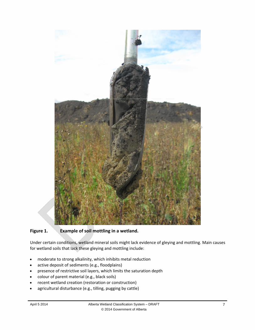
Wet soil processes, including the accumulation of peat and organic matter, and the development of
gleying and mottling, are important characteristics that distinguish mineral wetlands. When mineral soils
are saturated for prolonged periods, oxygen is depleted and metals such as iron (and in some cases
manganese) are reduced. In contrast, these metals are oxidized when soils are exposed to oxygen. Soil
redox processes lead to color changes in the soil profile. In soils with prolonged periods of saturation,
soil profiles often have a blue‐grey colour (gleying) resulting from iron reduction. Reduced iron is
mobile, and can concentrate in areas of the soil profile. When water levels recede and expose the soil, it
may become reoxidized, and produce red or brown mottles. Gleying and mottling are typical in Gleysolic
soils. The location of gleying and mottling in the soil profile can indicate the presence of water‐altered
soils. The presence of gleying and mottling in the rooting zone is diagnostic of mineral wetlands. Gleying
indicates relatively long periods of soil saturation, whereas mottling indicates fluctuating water levels
and alternating reduced and oxidized states.
April 5 2014 Alberta Wetland Classification System – DRAFT
© 2014 Government of Alberta
7
Figure 1. Example of soil mottling in a wetland.
Under certain conditions, wetland mineral soils might lack evidence of gleying and mottling. Main causes
for wetland soils that lack these gleying and mottling include:
moderate to strong alkalinity, which inhibits metal reduction
active deposit of sediments (e.g., floodplains)
presence of restrictive soil layers, which limits the saturation depth
colour of parent material (e.g., black soils)
recent wetland creation (restoration or construction)
agricultural disturbance (e.g., tilling, pugging by cattle)

April 5 2014 Alberta Wetland Classification System – DRAFT
© 2014 Government of Alberta
8
Although the presence of gleying and mottling indicates the presence of saturated soils, the absence of
these indicators does not necessarily confirm that the area is not a wetland.
1.5.5 Vegetation Structure and Composition
Characteristics of vegetation structure and composition differ among wetland classes, forms and types.
Vegetation structure is captured in wetland form, and is based on the tallest vegetation strata present in
a wetland. Vegetated strata in the AWCS include treed, shrubby, graminoid, and aquatic vegetation
cover. Vegetation structure often reflects hydrological processes, with taller vegetation strata generally
reflecting lower water levels.
Vegetation structure is also correlated with diversity and is generally higher in wetlands with more
complex structure (i.e., those with multiple strata) than those with a simple structure (i.e, submersed
aquatic vegetation). For example, wooded fens with several strata tend to be more diverse than
graminoid fens. Wildlife use of wetlands also relates to vegetation structure because different strata
provide food and shelter for different species.
Hydrophytes are plants that preferentially grow in wet areas. Most hydrophytes are adapted to growing
in soils that are saturated in a plant’s rooting zone (i.e., uppermost 30 cm), or in shallow open water
environments. Generally, the rooting zone of a hydrophyte extends below the water table, although soil
properties may allow for capillary action to bring moisture to the surface. Although this is a general rule,
not all species present in a wetland are unique to wet environments. Some upland plant species might
encroach in wetlands during drier periods, or are tolerant of wet conditions even though they do not
favour them. Only plants that favour wet environments are considered hydrophytic plants.
Vegetation indicators can often be used as a proxy for important environmental gradients such as water
levels and hydroperiod, pH, acidity, salinity and nutrient availability. Hence, vegetation can be used as a
key characteristic in wetland classification; it is an easily observed, aboveground feature (some
vegetation can be detected by imagery) and often reflects relatively long‐term characteristics of a
wetland. Although individual species might not be characteristic of an individual wetland class, form or
type, certain species assemblages can be diagnostic.
Climatic cycles that influence water levels and hydroperiod are typically accompanied by changes in
vegetation. As drawdown occurs in drought years, pioneer species and annuals can establish on bare
ground; in dry years or periods of drought, cultivation may occur throughout a wetland. When a wetland
is reflooded, graminoids and other wetland species reestablish themselves. During periods when a
wetland is extensively flooded, graminoid plants can thin or die off, thereby increasing the shallow open
water area. As conditions begin to dry up again, the water levels in a wetland recede and the cycle
repeats itself. These water fluctuations provide growing conditions and habitat for a much greater
diversity of species than would be found under stable water conditions, and facilitate processes such as
decomposition and productivity, elemental cycling and biogeochemical reactions. Basing wetland
classification on a single visit, or on information collected from a single year or time of year, provides
only a snapshot of a wetland and does not reflect its dynamic processes. When in doubt, soil
characteristics, such as the presence of peat of water‐altered soils, are the most stable characteristic of
wetland‐related processes.

April 5 2014 Alberta Wetland Classification System – DRAFT
© 2014 Government of Alberta
9
1.6 WETLAND DISTRIBUTION
Wetlands may occur naturally in basins or depressions that are isolated from surface connections to
other water bodies, or they may occur adjacent to rivers, lakes, ponds, wetlands and other water
bodies. They can be located in numerous landscape positions and settings, including floodplains, springs,
river islands, and glacial channels. Climate and landscape factors determine whether conditions are
suitable for a wetland to form and be sustained. These factors can include precipitation and
temperature, topography and landscape position, bedrock and surficial geology, and water inputs and
interactions.
In Alberta, bogs and fens are the most common wetland class in northern Alberta and cover vast
expanses of the Boreal Region. In addition to being peat‐accumulating wetlands, peatlands are
characterized by a well‐established ground cover of bryophytes that include mosses and liverworts.
Relatively stable water tables, slow‐moving water flow, and freshwater conditions all support the
development of a well‐established ground cover of bryophytes in peatlands. Stable water levels and
slow‐moving water flow also help to develop anaerobic conditions that lower decomposition rates. As
peat accumulates under these conditions, nutrients are stored in a non‐available form, causing nutrient
deficiencies in peatland. Further south, a transition occurs whereby peat‐accumulating wetlands are
replaced by wetlands on mineral soils, such as marshes and shallow open waters.
Mineral wetlands are present throughout the province, and are the most common type of wetland in
the Parkland and Grassland Regions of Alberta. They are mostly found in landscape positions where
water levels fluctuate (e.g., adjacent to rivers and open waterbodies, knob and kettle basins, shallow
prairie pothole depressions), or in areas where salinity concentrations restrict the establishment of
many freshwater herbaceous species and bryophytes.
1.7 TAXONOMY
The scientific names for all vascular plants and bryophytes in this report follow the Integrated
Taxonomic Information System (ITIS 2014). Common names follow those widely used in Alberta (ACIMS
2013).
For a preliminary list of Alberta wetland plants, including the wetland classes in which these species
typically occur, see Appendix C.
April 5 2014 Alberta Wetland Classification System – DRAFT
© 2014 Government of Alberta
10
Table 2. Wetland classes, forms and types in the Alberta Wetland Classification System. Mapping codes are in parentheses.
CLASS FORM TYPES1
Bog (B) Wooded, coniferous [Wc] Shrubby [S]
Acidic [a], freshwater (f)
Fen (F) Wooded, coniferous [Wc] Shrubby [S] Graminoid [G]
Poor fen [p], freshwater (f)
Moderately‐rich fen [mr], freshwater (f)
Extremely‐rich fen [er], slightly brackish (sb)
Marsh (M) Graminoid [G] Temporary hydroperiod [II]; freshwater (f) to slightly brackish (sb)
Seasonal hydroperiod [III]; freshwater (f) to moderately brackish (mb)
Semi‐permanent hydroperiod [IV] ; freshwater (f) to brackish (b)
Shallow Open Water (W)
Submersed and/or floating aquatic vegetation [A]
Unvegetated [Un]
Seasonal [III] hydroperiod; freshwater (f) to moderately brackish (mb)
Semi‐permanent hydroperiod [IV]; freshwater (f) to subsaline (ss)
Permanent hydroperiod [V]; slightly brackish (sb) to subsaline (ss)
Intermittent hydroperiod [VI]; saline (s)
Swamp (S) Wooded, coniferous [Wc] Wooded, mixedwood [Wm] Wooded, deciduous [Wd] Shrubby [S]
2Temporary [II]; freshwater (f) to slightly brackish (sb)
2Seasonal [III]; freshwater (f) to slightly brackish (sb)
2Seasonal [III]; moderately brackish (mb) to sub‐saline (ss)
Ephemeral Water Body (E)
Ephemeral [I]; freshwater (f)
1 Roman numerals are equivalent to the Stewart and Kantrud (1971) classification system 2Swamp types are only applicable shrubby swamps. Wooded swamps are not classified to type because of a lack of available information
April 5 2014 Alberta Wetland Classification System – DRAFT
© 2014 Government of Alberta
11
2. KEY TO THE WETLAND CLASSES AND FORMS OF ALBERTA
The following key presents sets of contrasting features under each number, only one of which should
apply to a given site. Each choice leads to another set of features and eventually to the classification of
the wetland up to its class and form. Once wetland class and form have been determined, proceed to
the detailed descriptions in Sections 3.0 to 6.0 to verify the wetland classification and classify the site to
its wetland type.
Classification Key to Wetland Classes and Forms
1.
1a. Terrain not affected by high water table or excess surface water, or if affected, only for a short period of days after spring snowmelt or heavy rainfall. Upland species that do not favour wet environments make up the majority of plant species ..................................................... proceed to 2
1b. Terrain affected by the water table near, at or above the land surface, and which is saturated for sufficient time to promote water‐altered soils, growth of hydrophytic vegetation, and other biological activities adapted to a wet environment. If surface water is present, it is less than 2 m deep at midsummer ............................................................................................................... skip to 3
2. Non‐Wetlands
2a. No evidence of water‐altered soils or surface water, including staining and other hydrologic indicators .................................................................................................................................. Upland
2b. Evidence of water‐altered soils may be found 30 cm below the ground surface or may not be present at all. Surface water is present in most years, but only for a brief period of days after snowmelt or a significant rainfall. Although, some hydrophyes may be present, they are not dominant and are intermixed with upland species ........................................ Ephemeral water body
3. Wetlands
3a. Wetland characterized by the accumulation of 40 cm or more peat. Organic matter has a von Post decomposition of 5 or less .............................................................................................. proceed to 4
3b. Wetland characterized by the accumulation of less than 40 cm of peat. Organic matter has a von Post decomposition of 6 or greater. ....................................................................................... skip to 7
4. Peatlands
4a. Peatland is ombrogenous, receiving surface water solely from precipitation, and is not influenced by groundwater or surface water. Water chemistry is fresh (< 500 µS/cm) and acidic (pH < 4.5). The site is elevated above the water table, which is usually found more than 40 cm below the surface. A dense ground cover of non‐vascular species is typically present and can include sphagnum mosses, feather mosses and lichens. Wooded coniferous and shrubby forms may occur, with shrubs characterized by ericaceous species; trees, when present, are typically restricted to black spruce ................................................................................................ proceed to 5
4b. Peatland is minerogenous, potentially receiving surface water from a number of sources, including surface water that has been in contact with mineral soil, groundwater and precipitation. The pH of the water is greater than 4.5, and the water content contains more dissolved minerals than would occur from precipitation alone. A dense ground cover of non‐vascular species is typically present
April 5 2014 Alberta Wetland Classification System – DRAFT
© 2014 Government of Alberta
12
and can include sphagnum and brown mosses. Wooded coniferous, shrubby and graminoid forms may occur ............................................................................................................................... skip to 6
5. Bog forms
5a. Bog has more than 5% tree cover of black spruce .................................. Wooded Bogs [Section 3.1]
5b. Bog has no more than 5% tree cover and at least 25% shrub cover .................................................... .................................................................................................................. Shrubby Bogs [Section 3.2]
6. Fen forms
6a. Fen has more than 5% tree cover of black spruce and tamarack ......................................................... .................................................................................................................. Wooded Fens [Section 4.1]
6b. Fen has no more than 5% tree cover and at least 25% shrub cover ........ Shrubby Fens [Section 4.2]
6c. Fen has no more than 5% tree cover and less than 25% shrub cover cover ........................................ .............................................................................................................. Graminoid Fens [Section 4.3]
7. Mineral Wetlands
7a. Mineral wetland with water levels near, at or above the ground surface for variable periods during the year, but for long enough to promote water‐altered soils within 30 cm of the surface and the growth of water‐tolerant graminoids. A wet meadow, shallow wetland, or deep wetland plant community may inhabit the deepest portion of the wetland. Shrubs occupy less than 25% of the wetland and tree cover is less than 5% ............................................................ Marshes [Section 5.1]
7b. Mineral wetland with water levels near, at or above the ground surface variable periods during the year. Has continuous, unshaded open water during the growing season that is less than 2 meters deep in midsummer. Submersed and/or floating aquatic vegetation may inhabit the deepest portion of the basin, or the open water area may be unvegetated. Shrubby plant cover occupies less than 25% of the wetland and tree cover is less than 5% ................................................ .................................................................................................... Shallow Open Waters [Section 5.2]
7c. Mineral wetland with water levels near, at or above the ground surface for variable periods during the year, and either has more than 5% tree cover of a variety of species or at least 25% shrub cover ................................................................................................................................ proceed to 8
8. Swamps
8a. Mineral wetland with water levels near, at or above the ground surface for variable periods during the year, and with more than 5% tree cover, of which 75% or more is coniferous species .......................................................................................... Coniferous Wooded Swamp [Section 6.1]
8b. Mineral wetland with water levels near, at or above the ground surface for variable periods during the year, and with more than 5% tree cover, including a mix of coniferous and deciduous species, where neither exceeds 75% of the total tree cover ............................................................................. ........................................................................................ Mixedwood Wooded Swamp [Section 6.2]
8c. Mineral wetland with water levels near, at or above the ground surface for variable periods during the year, and with more than 5% tree cover, of which 75% or more is deciduous species ................. ........................................................................................... Deciduous Wooded Swamp [Section 6.3]
8d. Mineral wetland with no more than 5% tree cover and at least 25% shrub cover .............................. ............................................................................................................. Shrubby Swamp [Section 6.4]
April 5 2014 Alberta Wetland Classification System – DRAFT
© 2014 Government of Alberta
13
3. BOGS
The ground surface of bogs is composed of peat and is isolated from the surface water and groundwater
influences either by landscape location (i.e., closed depressions with no sources of water inflow) or,
more commonly, by elevation (i.e., ground surface is 40 cm or more above the water table). Elevation of
the ground surface can result from the accumulation of peat or permafrost formation. As a result,
surface water in bogs is exclusively fed by precipitation and are thus considered to be ombrogenous
systems.
Bogs are permanent wetlands, such that moisture levels are effectively maintained by capillary action of
sphagnum mosses. In northern Alberta, permafrost can occur in peatlands where low mean annual
temperatures and insulation of peat result in ground temperatures that remain below freezing.
3.1 WOODED BOGS
Wooded bogs have more than 5% cover of coniferous trees, specifically black spruce (Picea mariana)
that are more than 3 m tall. These trees tend to be small and stunted, rarely reaching heights greater
than 10 m. Common Labrador tea (Rhododendron groenlandicum) is the predominant understory shrub,
often interspersed with bog cranberry (Vaccinium vitis‐idaea), cloudberry (Rubus chamaemorus) and
small bog cranberry (Vaccinium oxycoccos). Taller ericaceous shrubs such as bog rosemary (Andromeda
polifolia), leatherleaf (Chamaedaphne calyculata) and northern laurel (Kalmia polifolia) can also be
frequently present. Sheathed cottongrass (Eriophorum vaginatum) is the most common graminoid in
wooded bogs.
In wooded bogs where the water table is closer to the surface, thick mats of sphagnum mosses
(Sphagnum spp.) blanket the ground, including cuspidatum peat moss (Sphagnum cuspidatum), midway
peat moss (Sphagnum magellanicum), poor‐fen sphagnum (Sphagnum angustifolium) and rusty peat
moss (Sphagnum fuscum). These species are often interspersed with round‐leafed sundew (Drosera
rotundifolia), scattered sedges (Carex spp.) and other bryophytes, including the liverwort (Mylia
anomala) and slender haircap moss (Polytrichum strictum).
In wooded bogs where the water table is further from the surface, balticum peat moss
(Sphagnum balticum), dicranum mosses (Dicranum spp.), lichens, Schreber's moss (Pleurozium
schreberi) and stair‐step moss (Hylocomium splendens) are more typical.
3.2 SHRUBBY BOGS
Shrubby bogs have less than 5% tree cover and at least 25% cover by shrubs. Most shrubs are less than
1 m tall. Shrub and ground species are similar to wooded bogs, with sheathed cottongrass (Eriophorum
vaginatum) being the most prevelant graminoid. Sphagnum mosses (Sphagnum spp.), including midway
peat moss (Sphagnum magellanicum), and poor‐fen sphagnum (Sphagnum angustifolium), often
dominate the ground surface. In some cases, less common species of sphagnum mosses can dominate,
such as wide‐tongued peat moss (Sphagnum russowii). Other common species that are frequently
present but typically less abundant include common green bryum moss (Bryum pseudotriquetrum),
slender haircap moss (Polytrichum strictum) and tufted moss (Aulacomnium palustre).

April 5 2014 Alberta Wetland Classification System – DRAFT
© 2014 Government of Alberta
14
3.3 BOG TYPES
Bogs are not subdivided into types. All bogs are relatively acidic, generally having a pH of less than 4.6.
As bogs are exclusively fed by precipitation, they are freshwater wetlands (conductivity of < 500 μs/cm).
Bog flora is adapted to a freshwater environment and cannot tolerate elevated salinity. Other
characteristics common to all bogs include low decomposition rates and low nutrient availability in
comparison to mineral wetlands.
4. FENS
Fens are peatlands with ground and/0r surface water connections to the water table. Fens are
minerogenous systems, meaning they receive water from a variety of sources, and carry dissolved
minerals that make the water chemistry more alkaline than bogs.
Fen vegetation is typically dominated by sedges (Carex spp.) on the ground layer. When present, shrubs
are 1 m to 2 m tall. Black spruce (Picea mariana) and tamarack (Larix laricina) are usually found in
wooded fens. Many vascular plants that are common in fens are not typically found in bogs. Some of
these species include bog muhly (Muhlenbergia glomerata), buck‐bean (Menyanthes trifoliata), hairy‐
fruit sedge (Carex lasiocarpa), mud sedge (Carex limosa), tall white bog orchid (Platanthera dilatata),
sweet gale (Myrica gale), tamarack (Larix laricina), sticky false asphodel (Tofieldia glutinosa) and willows
(Salix spp.). Note that use of the word ‘bog’ in common species names can be misleading.
4.1 WOODED FENS
Wooded fens have more than 5% cover by conifers greater than 3 m in height. Black spruce (Picea
mariana) and tamarack (Larix laricina) dominate the treed stratum of wooded fens; black spruce is more
prevalent in poor fens whereas tamarack is more commonly found in extreme‐rich fens. Water tables in
wooded fens are typically 20 cm below the ground surface. Shrub birches (Betula spp.) and willows (Salix
spp.) are common understory shrubs, often with a lower ground layer stratum of common Labrador tea
(Rhododendron groenlandicum). Below this, thick mats of brown and sphagnum mosses as well as
graminoids and forbs can blanket the ground. The assemblage of species that makes up the ground
cover depends on fen type.
4.2 SHRUBBY FENS
Shrubby fens have 5% or less tree cover and at least 25% cover by shrubs. Water tables in shrubby fens
are typically closer to the surface than in wooded fens, occurring approximately 10 cm below the ground
surface. Common species include bog birch (Betula nana), dwarf birch (Betula pumila) and willows, such
as bog willow (Salix pedicellaris) and hoary willow (Salix candida). These shrub species usually reach 1 m
to 2 m in height, and are taller than the ericaceous shrubs that dominate bogs. Shrubs such as common
Labrador tea (Rhododendron groenlandicum), leatherleaf (Chamaedaphne calyculata) and sweet gale
(Myrica gale) can also be present. Thick mats of brown and sphagnum mosses can blanket the ground,
interspersed with a variety of graminoids and forbs. Like wooded fens, the assemblage of species that
makes up the ground cover depends on fen type.

April 5 2014 Alberta Wetland Classification System – DRAFT
© 2014 Government of Alberta
15
4.3 GRAMINOID FENS
Graminoid fens have less than 25% woody plant cover. Water levels in graminoid fens are typically at or
very close to the ground surface. Brown and sphagnum mosses cover the ground and are intermixed
with sedges and forbs. The assemblage of species that makes up the ground cover depends on fen type.
4.4 FEN TYPES
Fens are permanent wetlands and are saturated with water throughout the year. Because of the variety
of water sources, fen water chemistry and vegetation can be quite variable. Fens are freshwater (and
sometimes slightly brackish water) peatlands with relatively low salinity and available nutrients. Acidity
and alkalinity can be quite variable, with pH ranges from acidic to basic.
Poor, moderate‐rich and extreme‐rich fens exist in Alberta. Although these descriptors may refer to the
number of indicator species present in other scientific papers, they are related in this classification
system to the acidity–alkalinity gradient of the water. Poor fens have a low pH and little to no alkalinity.
In contrast, extreme‐rich fens have a higher pH and alkalinity. The acidity‐alkalinity gradient does not
correlate with a nutrient gradient, as poor fens, moderate‐rich fens and extreme‐rich fens all having low
amounts of availabile nutrients.
Poor and moderate‐rich fens are freshwater peatlands, whereas extreme‐rich fens have slightly brackish
water. Freshwater–poor fens tend to occur in headwaters like Alberta’s northern highlands, where
surface water inputs are more influencial and groundwater flow paths are shallow (e.g., Stony
Mountain, Birch Mountains and Caribou Mountains). Freshwater–poor fens also occur in areas of the
province where bedrock and surficial deposits are acidic (i.e., Canadian Shield Region), or along the
margin of large bogs that influence surface water chemistry. Moderate‐rich fens and extreme‐rich fens
have a greater amount of groundwater discharge and are more typical at lower landscape positions or in
association with coarse‐grained surficial deposits (e.g., glaciofluvial and aeolian). Greater amounts of
groundwater discharge result in higher alkalinity, which buffers the acidity generated, particularly in
extreme‐rich fens. Rich fens are subdivided into freshwater and slightly brackish types. The three fen
forms (i.e., wooded, shrubby and graminoid) can all exist as poor, moderate‐rich and extreme‐rich types.
Classification of fen types is usually distinguished by ground layer species assemblages.
Classification Key to Fen Types
Treed, shrubby and graminoidal fen forms can all have poor, moderate‐rich and extreme‐rich types.
1. Freshwater fen with an electrical conductivity less than 500 µS/cm and a pH less than 5.5 ......................
..................................................................................................................................................... Poor–Fen
2. Freshwater fen with an electrical conductivity less than 500 µS/cm and a pH between 5.5 and 7.0 .................................................................................................................................... Moderate‐Rich–Fen
3. Slightly brackish fen with an electrical conductivity between 500 µS/cm to 2,000 µS/cm and a pH of greater than 7.0 ............................................................................................................. Extreme‐Rich–Fen
April 5 2014 Alberta Wetland Classification System – DRAFT
© 2014 Government of Alberta
16
Poor-Fens
Characteristics of a poor‐fen may include:
Electrical conductivity of less than 500 µS/cm.
pH of less than 5.5.
Ground cover of graminoids that can include species such as few‐fruited sedge (Carex oligosperma),
hairy‐fruit sedge (Carex lasiocarpa), mud sedge (Carex limosa), prostrate sedge (Carex chordorrhiza),
and sheathed cottongrass (Eriophorum vaginatum). Typical forbs include bog muhly (Muhlenbergia
glomerata), buck‐bean (Menyanthes trifoliata), marsh cinquefoil (Comarum palustre), pitcher‐plant
(Sarracenia purpurea), three‐leafed Solomon’s‐plume (Maianthemum trifolium), and water arum
(Calla palustris). Additional species that can occur but in low abundance include cloudberry (Rubus
chamaemorus) and scheuchzeria (Scheuchzeria palustris). Flat‐leafed bladderwort (Utricularia
intermedia) can be present in pools. Bryophyte cover is typically dominated by various species of
sphagnum mosses, including pendant branch peat moss (Sphagnum jensenii), poor‐fen sphagnum
(Sphagnum angustifolium), thin‐leaved peat moss (Sphagnum teres), midway peat moss (Sphagnum
magellanicum), rusty peat moss (Sphagnum fuscum), and shore‐growing peat moss (Sphagnum
riparium). Brown mosses, which are frequently present in low abundance, include copper wire moss
(Pohlia nutans), common green bryum moss (Bryum pseudotriquetrum), and tufted moss
(Aulacomnium palustre), as well as many liverworts.
Moderate-Rich Fens
Characteristics of a moderate‐rich fen may include:
Electrical conductivity less than 500 µS/cm
pH between 5.5 and 7.0
Ground cover of sedges, including species found in poor fens, such as hairy‐fruit sedge (Carex
lasiocarpa), prostrate sedge (Carex chordorrhiza) and mud sedge (Carex limosa), as well as other
species more typical of moderate‐rich fens. These include the three‐seeded sedge (Carex trisperma),
two‐stamened sedge (Carex diandra) and water sedge (Carex aquatilis). Typical forbs found in
moderate‐rich fens include buck‐bean (Menyanthes trifoliata), marsh cinquefoil
(Comarum palustre), pitcher‐plant (Sarracenia purpurea), three‐leafed Solomon’s‐plume
(Maianthemum trifolium) and water arum (Calla palustris). Species such as seaside arrow‐grass
(Triglochin maritime) and tufted clubrush (Trichophorum caespitosum) can also be present in low
abundance. Flat‐leafed bladderwort (Utricularia intermedia) is sometimes present in pools.
Bryophyte ground cover is typically dominated by brown mosses, including aduncus brown moss
(Drepanocladus aduncus), golden moss (Tomenthypnum nitens), hamatocaulis moss (Hamatocaulis
lapponicus), hamatocaulis brown moss Hamatocaulis vernicosus), limprichtia brown moss
(Limprichtia revolvens) and twisted bog moss (Sphagnum subsecundum). Sphagnum mosses can be
present and in some cases dominate bryophyte cover. Typical sphagnum moss species include poor‐
fen sphagnum (Sphagnum angustifolium), rusty peat moss (Sphagnum fuscum) and warnstorfia peat
moss (Sphagnum warnstorfii). Other species that are frequently present but occur in low abundance
include moss (Bryum pseudotriquetrum), tufted moss (Aulacomnium palustre) and wavy dicranum
moss (Dicranum polysetum).

April 5 2014 Alberta Wetland Classification System – DRAFT
© 2014 Government of Alberta
17
Extreme-Rich Fens
Groundwater is an important component of extreme‐rich fens. In some cases, extreme‐rich fens can be
indicators of geologic features such as springs, and are often associated with the deposition of marl. In
northeastern Alberta, extreme‐rich fens are typically found on glaciofluvial deposits at the base of
uplands where regional groundwater flow paths discharge near or at the surface. The constant supply of
groundwater throughout the growing season maintains the water level at the surface for the entire
growing season. In the spring, snowmelt can move as sheet flow on the still‐frozen surface of these fens
and deposit organic debris. This leads to the development of patterned fens that have distinctive
patterns of drier ridges (strings) and wetter pools (flarks).
Characteristics of extreme‐rich fen may include:
Electrical conductivity between 500 µS/cm and 2,000 µS/cm
pH greater than 7.0
Ground cover of sedges that typically include mud sedge (Carex limosa), buck‐bean (Menyanthes
trifoliata), marsh cinquefoil (Comarum palustre), pitcher‐plant (Sarracenia purpurea), seaside arrow‐
grass (Triglochin maritima), tufted clubrush (Trichophorum caespitosum) and water arum (Calla
palustris). Flat‐leafed bladderwort (Utricularia intermedia) can be present in pools.
Bryophyte cover is typically dominated by brown mosses, including giant calliergon moss (Calliergon
giganteum), golden moss (Tomenthypnum nitens), hamatocaulis moss (Hamatocaulis lapponicus),
hamatocaulis brown moss (Hamatocaulis vernicosus), limprichtia brown moss (Limprichtia
revolvens), scorpidium moss (Scorpidium scorpioides), three‐angled thread‐moss (Meesia triquetra)
and yellow starry fen moss (Campylium stellatum).

April 5 2014 Alberta Wetland Classification System – DRAFT
© 2014 Government of Alberta
18
5. MARSHES AND SHALLOW OPEN WATERS
Marshes and shallow open waters are mineral wetlands characterized by fluctuating water levels and
varying hydroperiods. They are dominated by herbaceous vegetation, although some wetlands may be
sparsely vegetated (e.g. saltflats). Marsh and shallow open water forms are classified by the vegetation
community occupying the deepest portion of the wetland in the majority of years.
Both nutrient and salinity levels vary widely in marshes and shallow open waters; however, many
mineral wetlands in Alberta are naturally eutrophic. Some of these wetlands may be isolated from
surface and groundwater connections (e.g. prairie pothole depressions), whereas others may receive
water from a variety of sources. Examples of marshes and shallow open waters with hydrologic
connections include recharge and discharge wetlands, and wetlands bordering lotic (e.g. streams) or
lentic (e.g. lakes) water bodies.
5.1 MARSHES
Marshes are mineral wetlands with water levels near, at or above the ground surface for variable
periods during the growing season. They can be classified by the presence and interspersion of
emergent plants (i.e. water‐tolerant graminoids) throughout the deepest portion of the wetland in the
majority of the years; marshes contain less than 25% woody plant cover, but may have willows and
other woody species scattered in and around the wetland margin.
Marshes are found in a wide range of landscape positions, but are most common in the Grassland and
Parkland Regions of Alberta. In these regions, they usually fill isolated shallow depressions or shallow
drainage ways. In the Boreal Region, they are less common and usually found along watercourses and
waterbodies where water levels tend to fluctuate. They are also found in areas where salinity limits the
growth of bryophytes and other salt‐intolerant plants.
5.2 SHALLOW OPEN WATERS
Shallow open waters typically support floating and/or submersed aquatic vegetation in the deepest
portion of the wetland, or may be devoid of vegetation altogether. Shallow open waters contain less
than 25% woody plant cover, and is distinguished from marshes by a continuous, unshaded open water
area that is present in most years and less than 2 m deep in midsummer. Depth measurements may be
required to differentiate them from lakes, ponds and other bodies of water. Emergent plants often
surround the open water zone in shallow open waters.
Many shallow open water systems have no inlets or outlets, and thus receive water from rain, overland
surface flow and/or groundwater discharge. Other shallow open water systems may have a widened
channel with continual inflow and outflow via surface streams. Like marshes, shallow open waters are
most commonly found in the Grassland and Parkland Regions of Alberta.
5.3 MARSH AND SHALLOW OPEN WATER TYPES
Marshes and shallow open waters are subdivided into types based on their hydroperiod and salinity.
Some wetlands will dry out for variable periods during the year, whereas others will retain water
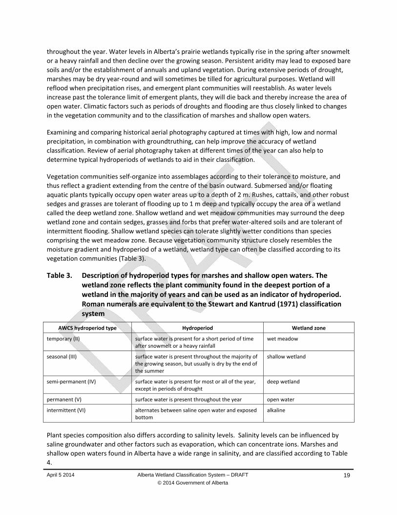
April 5 2014 Alberta Wetland Classification System – DRAFT
© 2014 Government of Alberta
19
throughout the year. Water levels in Alberta’s prairie wetlands typically rise in the spring after snowmelt
or a heavy rainfall and then decline over the growing season. Persistent aridity may lead to exposed bare
soils and/or the establishment of annuals and upland vegetation. During extensive periods of drought,
marshes may be dry year‐round and will sometimes be tilled for agricultural purposes. Wetland will
reflood when precipitation rises, and emergent plant communities will reestablish. As water levels
increase past the tolerance limit of emergent plants, they will die back and thereby increase the area of
open water. Climatic factors such as periods of droughts and flooding are thus closely linked to changes
in the vegetation community and to the classification of marshes and shallow open waters.
Examining and comparing historical aerial photography captured at times with high, low and normal
precipitation, in combination with groundtruthing, can help improve the accuracy of wetland
classification. Review of aerial photography taken at different times of the year can also help to
determine typical hydroperiods of wetlands to aid in their classification.
Vegetation communities self‐organize into assemblages according to their tolerance to moisture, and
thus reflect a gradient extending from the centre of the basin outward. Submersed and/or floating
aquatic plants typically occupy open water areas up to a depth of 2 m. Rushes, cattails, and other robust
sedges and grasses are tolerant of flooding up to 1 m deep and typically occupy the area of a wetland
called the deep wetland zone. Shallow wetland and wet meadow communities may surround the deep
wetland zone and contain sedges, grasses and forbs that prefer water‐altered soils and are tolerant of
intermittent flooding. Shallow wetland species can tolerate slightly wetter conditions than species
comprising the wet meadow zone. Because vegetation community structure closely resembles the
moisture gradient and hydroperiod of a wetland, wetland type can often be classified according to its
vegetation communities (Table 3).
Table 3. Description of hydroperiod types for marshes and shallow open waters. The wetland zone reflects the plant community found in the deepest portion of a wetland in the majority of years and can be used as an indicator of hydroperiod. Roman numerals are equivalent to the Stewart and Kantrud (1971) classification system
AWCS hydroperiod type Hydroperiod Wetland zone
temporary (II) surface water is present for a short period of time after snowmelt or a heavy rainfall
wet meadow
seasonal (III) surface water is present throughout the majority of the growing season, but usually is dry by the end of the summer
shallow wetland
semi‐permanent (IV) surface water is present for most or all of the year, except in periods of drought
deep wetland
permanent (V) surface water is present throughout the year open water
intermittent (VI) alternates between saline open water and exposed bottom
alkaline
Plant species composition also differs according to salinity levels. Salinity levels can be influenced by
saline groundwater and other factors such as evaporation, which can concentrate ions. Marshes and
shallow open waters found in Alberta have a wide range in salinity, and are classified according to Table
4.
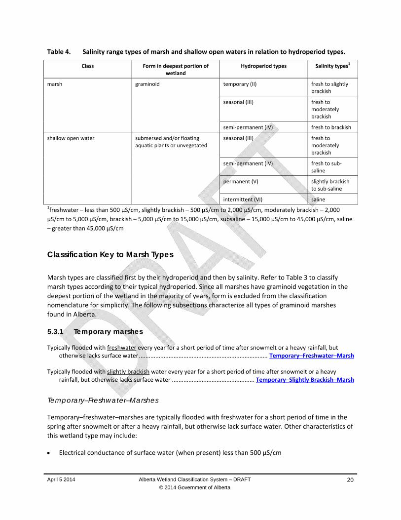
April 5 2014 Alberta Wetland Classification System – DRAFT
© 2014 Government of Alberta
20
Table 4. Salinity range types of marsh and shallow open waters in relation to hydroperiod types.
Class Form in deepest portion of wetland
Hydroperiod types Salinity types1
marsh graminoid temporary (II) fresh to slightly brackish
seasonal (III) fresh to moderately brackish
semi‐permanent (IV) fresh to brackish
shallow open water submersed and/or floating aquatic plants or unvegetated
seasonal (III) fresh to moderately brackish
semi‐permanent (IV) fresh to sub‐saline
permanent (V) slightly brackish to sub‐saline
intermittent (VI) saline 1freshwater – less than 500 µS/cm, slightly brackish – 500 µS/cm to 2,000 µS/cm, moderately brackish – 2,000
µS/cm to 5,000 µS/cm, brackish – 5,000 µS/cm to 15,000 µS/cm, subsaline – 15,000 µS/cm to 45,000 µS/cm, saline
– greater than 45,000 µS/cm
Classification Key to Marsh Types
Marsh types are classified first by their hydroperiod and then by salinity. Refer to Table 3 to classify
marsh types according to their typical hydroperiod. Since all marshes have graminoid vegetation in the
deepest portion of the wetland in the majority of years, form is excluded from the classification
nomenclature for simplicity. The following subsections characterize all types of graminoid marshes
found in Alberta.
5.3.1 Temporary marshes
Typically flooded with freshwater every year for a short period of time after snowmelt or a heavy rainfall, but otherwise lacks surface water .............................................................................. Temporary–Freshwater–Marsh
Typically flooded with slightly brackish water every year for a short period of time after snowmelt or a heavy
rainfall, but otherwise lacks surface water .................................................. Temporary–Slightly Brackish–Marsh
Temporary–Freshwater–Marshes
Temporary–freshwater–marshes are typically flooded with freshwater for a short period of time in the
spring after snowmelt or after a heavy rainfall, but otherwise lack surface water. Other characteristics of
this wetland type may include:
Electrical conductance of surface water (when present) less than 500 µS/cm
April 5 2014 Alberta Wetland Classification System – DRAFT
© 2014 Government of Alberta
21
Evidence of redox features (e.g., mottles and gleying) typically found within 20 cm of the ground
surface
A wet meadow community in the deepest part of the basin; species typically present include
bluejoint (Calamagrostis canadensis), fowl bluegrass (Poa palustris), graceful sedge (Carex
praegracilis), northern reed grass (Calamagrostis stricta ssp.inexpansa), Sartwell’s sedge (Carex
sartwelli), small bedstraw (Galium trifidum), tufted hairgrass (Deschampsia caespitosa), western
dock (Rumex occidentalis), marsh skullcap (Scutellaria galericulata) and wild mint (Mentha arvensis),
when the wetland has not been tilled for agricultural use
When the wetland has been tilled for agricultural use, the resulting bare ground that occurs after
flooding is susceptible to a variety of invasive species common to both uplands and wetlands
Temporary–Slightly Brackish–Marshes
Temporary–slightly brackish–marshes are typically flooded with slightly brackish water for a short period
of time in the spring after snowmelt or after a heavy rainfall, but otherwise lack surface water.
Characteristics of this wetland type may include:
Electrical conductance of surface water (when present) between 500 µS/cm and 2,000 µS/cm
Evidence of redox features (e.g., mottles and gleying) typically found within 20 cm of the ground
surface; organic soils typically do not develop.
A wet meadow community in the deepest part of the basin; species typically present include
bluejoint (Calamagrostis canadensis), fowl bluegrass (Poa palustris), foxtail barley (Hordeum
jubatum), tufted hairgrass (Deschampsia caespitosa), western dock (Rumex occidentalis, wild
mint (Mentha arvensis) and wire rush (Juncus balticus), when the wetland has not been tilled for
agricultural use
When the wetland has been tilled for agricultural use, the resulting bare ground that occurs after
flooding is susceptible to a variety of invasive species common to both uplands and wetlands
including quackgrass (Elymus repens)
5.3.2 Seasonal marshes
Typically flooded with freshwater for most of the growing season, but has little or no surface water remaining by the end of the summer ............................................................................................. Seasonal–Freshwater–Marsh
Typically flooded with slightly brackish water for most of the growing season, but has little or no surface water
remaining by the end of the summer ............................................................... Seasonal–Slightly Brackish–Marsh Typically flooded with moderately brackish water for most of the growing season, but has little or no surface water
remaining by the end of the summer ........................................................ Seasonal–Moderately Brackish–Marsh
Seasonal–Freshwater–Marshes
Seasonal–freshwater–marshes are flooded with freshwater throughout the majority of the growing
season, but have little or no surface water remaining by the end of the summer. Characteristics of this
wetland type may include:
Electrical conductance of surface water (when present) less than 500 µS/cm
April 5 2014 Alberta Wetland Classification System – DRAFT
© 2014 Government of Alberta
22
Evidence of redox features (e.g., mottles and gleying) typically found within 10 cm of the ground
surface
Organic soils with a von post decomposition of 6 or greater
A shallow wetland community in the deepest part of the basin; species typically present include
awned sedge (Carex atherodes), common tall mannagrass (Glyceria grandis), common waterparsnip
(Sium suave), reed canary grass (Phalaris arundinacea), short‐awned foxtail (Alopecurus aequalis),
sloughgrass (Beckmannia syzigachne), small bottle sedge (Carex utriculata) and water sedge (Carex
aquatilis), when the wetland has not been tilled for agricultural use.
When the wetland has been tilled for agricultural use, typical species include needle spikerush
(Eleocharis acicularis)
Species in the wet meadow community are the same as those associated with temporary‐
freshwater marshes
Seasonal–Slightly Brackish–Marshes
Seasonal–slightly brackish–marshes are flooded with slightly brackish water throughout the majority of
the growing season, but have little or no surface water remaining by the end of the summer.
Characteristics of this wetland type may include:
Electrical conductance of surface water (when present) between 500 µS/cm and 2,000 µS/cm
Evidence of redox features (e.g., mottles and gleying) typically found within 10 cm of the ground
surface
Organic soils with a von post decomposition of 6 or greater
A shallow wetland community in the deepest part of the basin; species typically present include
awned sedge (Carex atherodes), common waterparsnip (Sium suave), needle spikerush (Eleocharis
acicularis), short‐awned foxtail (Alopecuris aequalis), reed canary grass (Phalaris arundinacea),
sloughgrass (Beckmannia syzigachne), small bottle sedge (Carex utriculata), spangletop (Scolochloa
festucacea), water hemlock (Cicuta maculata), water sedge (Carex aquatilis) and water smartweed
(Persicaria amphibia, terrestrial form), when the wetland has not been tilled for agricultural use
When the wetland has been tilled for agricultural use, typical species include needle spikerush
(Eleocharis acicularis)
Species in the wet meadow community are the same as those associated with temporary‐slightly
brackish marshes
Seasonal–Moderately Brackish–Marshes
Seasonal–moderately brackish–marshes are flooded with moderately brackish water throughout the
majority of the growing season, but have little or no surface water remaining by the end of the summer.
Characteristics of this wetland type may include:
Electrical conductance of surface water (when present) between 2,000 µS/cm and 5,000 µS/cm
Evidence of redox features (e.g., mottles and gleying) typically found within 10 cm of the ground
surface
Organic soils with a von post decomposition of 6 or greater
A shallow wetland community in the deepest part of the basin; species typically present include
needle spikerush (Eleocharis acicularis), Nuttall’s salt‐meadow grass (Puccinellia nuttalliana), short‐
April 5 2014 Alberta Wetland Classification System – DRAFT
© 2014 Government of Alberta
23
awned foxtail (Alopecuris aequalis), sloughgrass (Beckmannia syzigachne) and spangletop
(Scolochloa festucacea), when the wetland has not been tilled for agricultural use
When the wetland has been tilled for agricultural use, typical species include quackgrass (Poa
pratensis) as well as red goosefoot (Chenopodium rubrum)
Moderately brackish, wet meadow species are often present along the margin; typical species
include foxtail barley (Hordeum jubatum), northern reed grass (Phalaris arundinacea), prairie cord
grass (Spartina pectinata) and wire rush (Juncus balticus)
5.3.3 Semi-permanent marshes
Typically flooded with freshwater year‐round in most years unless drought conditions persist ................................... ..................................................................................................................... Semi‐Permanent–Freshwater–Marsh
Typically flooded with slightly brackish water year‐round in most years unless drought conditions persist ................. ............................................................................................................. Semi‐Permanent–Slightly Brackish–Marsh Typically flooded with moderately brackish water year‐round in most years unless drought conditions persist .......... ...................................................................................................... Semi‐Permanent–Moderately Brackish–Marsh Typically flooded with brackish water year‐round in most years unless drought conditions persist .............................
.......................................................................................................................... Semi‐Permanent–Brackish–Marsh
Semi-Permanent–Freshwater–Marshes
Semi‐permanent–freshwater–marshes are flooded with freshwater water in most years unless drought
conditions persist. Characteristics of this wetland type may include:
Electrical conductance of surface water (when present) less than 500 µS/cm
Evidence of redox features (i.e., mottles and gleying) typically found at the ground surface
Organic soils with a von post decomposition of 6 or greater
A deep wetland community in the deepest part of the basin; species typically present include
common bladderwort (Utricularia vulgrais), common cattail (Typha latifolia), crystalwort (Riccia
flutians), common duckweed (Lemna minor), marsh marigold (Caltha palustris) and purple‐fringed
heartwort (Ricciocarpos natans)
Other vegetation zones can be present and comprise shallow wetland and wet meadow species that
are associated with freshwater conditions
Semi-Permanent–Slightly Brackish–Marshes
Semi‐permanent–slightly brackish–marshes are flooded with slightly brackish water in most years unless
drought conditions persist. Characteristics of this wetland type may include:
Electrical conductance of surface water (when present) between 500 µS/cm and 2,000 µS/cm
Evidence of redox features (e.g., mottles and gleying) typically found at the ground surface
Organic soils with a von post decomposition of 6 or greater

April 5 2014 Alberta Wetland Classification System – DRAFT
© 2014 Government of Alberta
24
A deep wetland community in the deepest part of the basin; species typically present include great
bulrush (Schoenoplectus acutus var. acutus), three‐square rush (Schoenoplectus pungens var.
pungens) and water smartweed (Persicaria amphibia, aquatic form)
Other vegetation zones can be present and comprise shallow wetland and wet meadow species that
are associated with slightly brackish conditions
Semi-Permanent–Moderately Brackish–Marshes
Semi‐permanent–moderately brackish–marshes are flooded with moderately brackish water in most
years unless drought conditions persist. Characteristics of this wetland type may include:
Electrical conductance of surface water (when present) between 2,000 µS/cm and 5,000 µS/cm
Evidence of redox features (e.g., mottles and gleying) typically found at the ground surface
Organic soils with a von post decomposition of 6 or greater
A deep wetland community (Table 2) in the deepest part of the basin; species typically present
include great bulrush (Schoenoplectus acutus var. acutus), ivy‐leaved duckweed (Lemna trisulca) and
three‐square rush (Schoenoplectus pungens var. pungens).
Other vegetation zones can be present and comprise shallow wetland and wet meadow species that
are associated with moderately brackish conditions
Semi-Permanent–Brackish–Marshes
Semi‐permanent–brackish–marshes are flooded with brackish water in most years unless drought
conditions persist. Characteristics of this wetland type may include:
Electrical conductance of surface water (when present) between 5,000 µS/cm and 15,000 µS/cm
Evidence of redox features (e.g., mottles and gleying) typically found at the ground surface
Organic soils with a von post decomposition of 6 or greater
A deep wetland community in the deepest part of the basin; species typically present include great
bulrush (Schoenoplectus acutus var. acutus) and three square rush (Schoenoplectus pungens var.
pungens)
Shallow wetland and wet meadow species that are associated with brackish conditions are often
present along the margin; typical species include creeping spike‐rush (Eleocharis palustris), Nuttall’s
salt‐meadow grass (Puccinellia nuttalliana), samphire (Salicornia rubra) and three‐square rush
(Schoenoplectus pungens var. pungens)
Classification Key for Shallow Open Water Types
Shallow open water types are classified first by their hydroperiod and then by salinity. Since all shallow
open waters have either submersed and/or floating aquatic plant growth or unvegetated open water
areas in the deepest portion of the wetland, wetland form is excluded from the classification
nomenclature for simplification.
5.3.4 Seasonal shallow open waters
Typically flooded with freshwater for most of the growing season, but has little or no surface water remaining by the end of the summer ..................................................................... Seasonal–Freshwater–Shallow Open Water
April 5 2014 Alberta Wetland Classification System – DRAFT
© 2014 Government of Alberta
25
Typically flooded with slightly brackish water for most of the growing season, but has little or no surface water
remaining by the end of the summer ....................................... Seasonal–Slightly Brackish–Shallow Open Water Typically flooded with moderately brackish water for most of the growing season, but has little or no surface water
remaining by the end of the summer ................................ Seasonal–Moderately Brackish–Shallow Open Water
Seasonal–Freshwater–Shallow Open Waters
easonal–freshwater–shallow open waters are flooded with freshwater for the majority of the growing
season, but have little or no surface water remaining by the end of the summer. Characteristics of this
wetland type may include:
Electrical conductance of surface water (when present) less than 500 µS/cm
Evidence of redox features (e.g., mottles and gleying) typically found within 10 cm of the ground
surface
Organic soils with a von post decomposition of 6 or greater
A submersed and/or floating aquatic vegetation community in the deepest part of the basin; species
typically present include common bladderwort (Utricularia vulgrais) and various‐leaved pondweed
(Potamogeton gramineus)
A wet meadow community can be present around the open water margin; species typically present
include bluejoint (Calamagrostis canadensis), fowl bluegrass (Poa palustris), graceful sedge (Carex
praegracilis), northern reed grass (Calamagrostis stricta ssp.inexpansa), Sartwell’s sedge (Carex
sartwelli), small bedstraw (Galium trifidum), tufted hairgrass (Deschampsia caespitosa), western
dock (Rumex occidentalis), marsh skullcap (Scutellaria galericulata) and wild mint (Mentha arvensis),
when the wetland has not been tilled for agricultural use.
Seasonal–Slightly Brackish–Shallow Open Waters
Seasonal–slightly brackish–shallow open waters are flooded with slightly brackish water for most of the
growing season, but have little or no surface water remaining by the end of the summer. Characteristics
of this wetland type may include:
Electrical conductance of surface water (when present) between 500 µS/cm and 2,000 µS/cm
Evidence of redox features (e.g., mottles and gleying) typically found within 10 cm of the ground
surface
Organic soils with a von post decomposition of 6 or greater
A submersed and/or floating aquatic vegetation community in the deepest part of the basin; species
typically present include common bladderwort (Utricularia vulgrais), large‐leaved white water
crowfoot (Ranunculus aquatilis var. diffuses), needle spikerush (Eleocharis acicularis submersed
form), small‐leaf pondweed (Potamogeton pusillus), water smartweed (Persicaria amphibia aquatic
form) and brown moss species of Drepanocladus spp.
A wet meadow community can be present around the open water margin; species typically present
include bluejoint (Calamagrostis canadensis), fowl bluegrass (Poa palustris), foxtail barley (Hordeum
jubatum), tufted hairgrass (Deschampsia caespitosa), western dock (Rumex occidentalis, wild mint
(Mentha arvensis) and wire rush (Juncus balticus), when the wetland has not been tilled for
agricultural use
April 5 2014 Alberta Wetland Classification System – DRAFT
© 2014 Government of Alberta
26
Seasonal–Moderately Brackish–Shallow Open Waters
Seasonal–moderately brackish–shallow open waters are flooded with moderately brackish water for
most of the growing season, but have little or no surface water remaining by the end of the summer.
Characteristics of this wetland type may include:
Electrical conductance of surface water (when present) between 2,000 µS/cm and 5,000 µS/cm
Evidence of redox features (e.g., mottles and gleying) typically found within 10 cm of the ground
surface
Organic soils with a von post decomposition of 6 or greater
A submersed and/or floating aquatic vegetation community in the deepest part of the basin; species
typically present include algae (Chara spp.), common bladderwort (Utricularia vulgrais), large‐leaved
white water crowfoot (Ranunculus aquatilis var. diffuses) and brown moss species (Drepanocladus
spp.)
Wet meadow species are often present along the margin that are associated with moderately‐
brackish conditions; typical species include foxtail barley (Hordeum jubatum), northern reed grass
(Phalaris arundinacea), prairie cord grass (Spartina pectinata) and wire rush (Juncus balticus)
5.3.5 Semi-permanent shallow open waters
Typically flooded with freshwater year‐round in most years unless drought conditions persist ................................... ............................................................................................. Semi‐Permanent–Freshwater–Shallow Open Water
Typically flooded with slightly brackish water year‐round in most years unless drought conditions persist .................
..................................................................................... Semi‐Permanent–Slightly Brackish–Shallow Open Water Typically flooded with moderately brackish water year‐round in most years unless drought conditions persist ..........
.............................................................................. Semi‐Permanent–Moderately Brackish–Shallow Open Water Typically flooded with brackish water year‐round in most years unless drought conditions persist .............................
.................................................................................................. Semi‐Permanent–Brackish–Shallow Open Water Typically flooded with subsaline water year‐round in most years unless drought conditions persist ............................
................................................................................................ Semi‐Permanent–Subsaline–Shallow Open Water
Semi-Permanent–Freshwater–Shallow Open Waters
Semi‐permanent–freshwater–shallow open waters are flooded with freshwater in most years unless
drought conditions persist. Characteristics of this wetland type may include:
Electrical conductance of surface water (when present) less than 500 µS/cm
Evidence of redox features (e.g., mottles and gleying) typically found at the ground surface
Organic soils with a von post decomposition of 6 or greater
A submersed and/or floating aquatic vegetation community in the deepest part of the basin; species
typically present include clasping‐leaf pondweed (Potamogeton richardsonii), common bladderwort
(Utricularia vulgrais), hornwort (Ceratophyllum demersum), large‐leaved white water crowfoot
(Ranunculus aquatilis var. diffuses), small‐leaf pondweed (Potamogeton pusillus) and spike water‐
milfoil (Myriophyllum sibricum)
April 5 2014 Alberta Wetland Classification System – DRAFT
© 2014 Government of Alberta
27
Vegetation zones can be present and comprise shallow wetland and wet meadow species that are
associated with freshwater conditions
Semi-Permanent–Slightly Brackish–Shallow Open Waters
Semi‐permanent–slightly brackish–shallow open waters are flooded with slightly brackish water in most
years unless drought conditions persist. Characteristics of this wetland type may include:
Electrical conductance of surface water (when present) between 500 µS/cm and 2,000 µS/cm
Evidence of redox features (i.e., mottles and gleying) typically found at the ground surface
Organic soils with a von post decomposition of 6 or greater
A submersed and/or floating aquatic vegetation community in the deepest part of the basin; species
typically present include clasping‐leaf pondweed (Potamogeton richardsonii), common bladderwort
(Utricularia vulgrais), hornwort (Ceratophyllum demersum), large‐leaved white water crowfoot
(Ranunculus aquatilis var. diffuses), small‐leaf pondweed (Potamogeton pusillus) and spike water‐
milfoil (Myriophyllum sibricum)
Vegetation zones can be present and comprise shallow wetland and wet meadow species that are
associated with slightly brackish conditions
Semi-Permanent–Moderately Brackish– Shallow Open Waters
Semi‐permanent–moderately brackish–shallow open waters are flooded with moderately brackish
water in most years unless drought conditions persist. Characteristics of this wetland type may include:
Electrical conductance of surface water (when present) between 2,000 µS/cm and 5,000 µS/cm
Evidence of redox features (e.g., mottles and gleying) typically found at the ground surface
Organic soils with a von post decomposition of 6 or greater
A submersed and/or floating aquatic vegetation community in the deepest part of the basin; species
typically present include algae (Chara spp.), horned pondweed (Zannichellia palustris), large‐leaved
white water crowfoot (Ranunculus aquatilis var. diffuses), sago pondweed (Stuckenia pectinata) and
water‐milfoil (Myriophyllum sibricum)
Vegetation zones can be present and comprise shallow water and wet meadow species that are
associated with moderately brackish conditions
Semi-Permanent–Brackish–Shallow Open Waters
Semi‐permanent–brackish–shallow open waters are flooded with brackish water in most years unless
drought conditions persist. Characteristics of this wetland type may include:
Electrical conductance of surface water (when present) between 5,000 µS/cm and 15,000 µS/cm
Evidence of redox features (e.g., mottles and gleying) typically found at the ground surface
Organic soils with a von post decomposition of 6 or greater
A submersed and/or floating aquatic vegetation community in the deepest part of the basin; species
typically present include algae (Chara spp.) and horned pondweed (Zannichellia palustris)
Shallow wetland and wet meadow species that are associated with moderately brackish conditions
are often present along the margin; typical species include foxtail barley (Hordeum jubatum),
April 5 2014 Alberta Wetland Classification System – DRAFT
© 2014 Government of Alberta
28
northern reed grass (Phalaris arundinacea), prairie cord grass (Spartina pectinata) and wire rush
(Juncus balticus)
Semi-Permanent–Subsaline–Shallow Open Waters
Semi‐permanent–subsaline–shallow open waters are flooded with subsaline water most years unless
drought conditions persist. Characteristics of this wetland type may include:
Electrical conductance of surface water (when present) between 15,000 µS/cm and 45,000 µS/cm
Evidence of redox features (e.g., mottles and gleying) typically found at the ground surface
Organic soils with a von post decomposition of 6 or greater
A submersed and/or floating aquatic vegetation community in the deepest part of the basin; species
typically present include algae (Chara spp.), horned pondweed (Zannichellia palustris), sago
pondweed (Stuckenia pectinata) and widgeon‐grass (Ruppia cirrhosa).
Shallow wetland and wet meadow species that are associated with subsaline conditions are often
present along the margin; typical species include alkali cordgrass (Spartina gracilis), common
seablite (Suaeda calceoliformis), foxtail barley (Hordeum jubatum), Nuttall’s salt‐meadow grass
(Puccinellia nuttalliana), salt grass (Distichlis spicata ssp. stricta), samphire (Salicornia rubra), seaside
arrow‐grass (Tryglochin maritima) and scratch grass (Muhlenbergia asperifolia)
5.3.6 Permanent shallow open waters
Flooded with slightly brackish water even during drought conditions ........................................................................... ............................................................................................... Permanent–Slightly Brackish–Shallow Open Water
Flooded with moderately brackish water even during drought conditions ....................................................................
....................................................................................... Permanent–Moderately Brackish–Shallow Open Water Flooded with brackish water even during drought conditions ........................................................................................
............................................................................................................Permanent–Brackish–Shallow Open Water Flooded with subsaline water even during drought conditions ......................................................................................
.......................................................................................................... Permanent–Subsaline–Shallow Open Water
Permanent–Slightly Brackish–Shallow Open Waters
Permanent–slightly brackish–shallow open waters are permanently flooded with slightly brackish water
even during drought years. Characteristics of this wetland type may include:
Electrical conductance of surface water (when present) between 500 µS/cm and 2,000 µS/cm
A submersed and/or floating aquatic vegetation community in the deepest part of the basin that is
almost exclusively widgeon‐grass (Ruppia cirrhosa)
Vegetation zones can be present and comprise deep wetland, shallow wetland and wet meadow
species that are associated with slightly brackish conditions
April 5 2014 Alberta Wetland Classification System – DRAFT
© 2014 Government of Alberta
29
Permanent–Moderately Brackish–Shallow Open Waters
Permanent–moderately brackish–shallow open waters are permanently flooded with moderately
brackish water even during drought years. Characteristics of this wetland type may include:
Electrical conductance of surface water (when present) between 2,000 µS/cm and 5,000 µS/cm
A submersed and/or floating aquatic vegetation community in the deepest part of the basin that is
almost exclusively widgeon‐grass (Ruppia cirrhosa)
Vegetation zones can be present and comprise deep wetland, shallow wetland and wet meadow
species that are associated with moderately brackish conditions
Permanent–Brackish–Shallow Open Waters
Permanent–brackish–shallow open waters are permanently flooded with brackish water even during
drought years. Characteristics of this wetland type may include:
Electrical conductance of surface water (when present) between 5,000 µS/cm and 15,000 µS/cm
A submersed and/or floating aquatic vegetation community in the deepest part of the basin that is
almost exclusively large‐sheath pondweed (Stuckenia vaginata), and widgeon‐grass (Ruppia
cirrhosa)
Vegetation zones can be present and comprise deep wetlnad, shallow wetland and wet meadow
species that are associated with brackish conditions
Permanent–Subsaline–Shallow Open Waters
Permanent–subsaline–shallow open waters are permanently flooded with subsaline water even during
drought years. Characteristics of this wetland type may include:
Electrical conductance of surface water (when present) between 15,000 µS/cm and 45,000 µS/cm
A lack of submersed and/or floating aquatic vegetation
Vegetation zones can be present and comprise deep wetland, shallow wetland and wet meadow
species that are associated with subsaline conditions
5.3.7 Intermittent shallow open waters
Intermittently flooded with saline water ........................................................................................................................ ............................................................................................................. Intermittent–Saline–Shallow Open Water
Intermittent–Saline–Shallow Open Waters
Intermittent–saline–shallow open waters are characterized by saline water that is intermittently
present. When this wetland type is not flooded, glistening‐white alkali saltflats are exposed that are
primarily composed of sodium and magnesium chlorides and sulphates. Characteristics of this wetland
type may include:
Electrical conductance of surface water (when present) greater than 45,000 µS/cm
Presence of a submersed alkaline wetland community in the deepest part of the basin that is almost
exclusively widgeon‐grass (Ruppia cirrhosa)

April 5 2014 Alberta Wetland Classification System – DRAFT
© 2014 Government of Alberta
30
6. SWAMPS
Swamps are wooded or shrubby mineral wetlands. Depending on the moisture regime and hydrology,
swamps may or may not accumulate organic matter. Swamps are generally considered non‐peat
accumulating wetlands, although there may be exceptions. Water in swamps is nutrient‐rich and
fluctuates throughout the year. Many swamps along rivers are flooded annually. Although flooding can
occur for extended periods, water levels typically decline during the growing season, and surficial water
either disappears or only persists in depressions. Groundwater always remains close to the surface,
within reach of tree and shrub roots. The ground surface in swamps is often very hummocky, and deep,
water‐filled depressions alternate with elevated surfaces on which trees and shrubs tend to grow.
Swamps can develop in a variety of environments, including the margins of peatlands, river floodplains
and deltas, alluvial fans, and the margins of marshes and shallow open waters. Swamps often form a
transition zone between peatlands and surrounding uplands and can occur across broad, level plains in
the Boreal Region or in the bottom of river valleys.
Swamps are defined as mineral wetlands that have at least 5% tree cover or at least 25% shrub cover.
Swamp forms are subdivided based on the presence or absence of trees (wooded or shrubby) as well as
by the stand type (i.e., coniferous, mixedwood and deciduous).
6.1 CONIFEROUS WOODED SWAMPS
Coniferous wooded swamps have more than 5% tree cover and have coniferous species comprising 75%
or more of the total tree cover. Coniferous swamps are typically made up of black spruce (Picea
mariana) and occasionally tamarack (Larix laricina). White spruce (Picea glauca) is occasionally present.
Since the rooting zone lies in contact with mineral‐rich groundwater, trees flourish, often reaching
heights greater than 10 m in closed‐canopy stands. The understory of coniferous wooded swamps
supports a variety of shrubs, including alders (Alnus spp.), bog birch (Betula nana), common Labrador
tea (Rhododendron groenlandicum) and dwarf birch (Betula pumila). The ground surface is hummocky,
often with pools of standing water around the base of trees. Ground cover includes bunchberry (Cornus
canadensis), dewberry (Rubus pubescens), long‐leaved chickweed (Stellaria longifolia), northern
starflower (Trientalis borealis) and small bedstraw (Galium trifidum). Scattered bryophytes can be
found, but are more common in open stands. Feathermosses may also be present.
6.2 MIXEDWOOD WOODED SWAMPS
Mixedwood wooded swamps have canopies with at least 5% tree cover that can includes a mix of
coniferous and deciduous species, of which neither individually exceeds 75% of the tree cover. Alaska
birch (Betula neoalaskana), balsam poplar (Populus balsamifera) and black spruce (Picea mariana) are
typical species, and white spruce (Picea glauca) and tamarack (Larix laricina) are occasionally present.
Shrubs are typically more than 2 m in height and include species of alder (Alnus spp.), Bebb willow (Salix
bebbiana), common Labrador tea (Rhododendron groenlandicum), skunk currant (Ribes glandulosum),
pussy willow (Salix discolor) and wild red current (Ribes triste). As with coniferous swamps, the ground
surface is hummocky, often with pools of standing water around the base of trees. Ground cover species
include the same species found in coniferous wooded swamps as well as arrow‐leaved coltsfoot

April 5 2014 Alberta Wetland Classification System – DRAFT
© 2014 Government of Alberta
31
(Petasites frigidus var. sagittatus) and horsetails (Equisetum spp.). Scattered bryophytes can be found
and typically include feather mosses and moss species such as Amblystegium serpens, Climacium
dendroides, Jamesoniella autumnalis, Lophocolea heterophylla and Plagiomnium ellipticum.
6.3 DECIDUOUS WOODED SWAMPS
Deciduous wooded swamps have canopies with at least 5% tree cover and deciduous species comprising
75% or more of the tree cover. Alaska birch (Betula neoalaskana), balsam poplar (Populus balsamifera)
and white birch (Betula papyrifera) are typcial tree species. Black spruce (Picea mariana), white spruce
(Picea glauca) and tamarack (Larix laricina) are occasionally present. Deciduous wooded swamps are
often associated with alluvial fans found along the base of many of Alberta’s northern highlands where
nutrient input is exceptionally high for the boreal forest. In the river valleys of southern Alberta,
cottonwood and poplar species are typically present, including balsam poplar (Populus balsamifera),
plains cottonwood (Populus deltoids) and narrow‐leaf cottonwood (Populus angustifolia).
Shrub species are similar to mixedwood swamps, although they are typically more robust and often
include Manitoba maple (Acer negundo) and red osier dogwood (Cornus sericea). Ground cover species
are diverse and include species present in mixedwood wooded swamps as well as common marsh
marigold (Caltha palustris), gold saxifrage (Chrysosplenium spp.), kidney‐leaved violet (Viola renifolia),
marsh violet (Viola palustris), sedges (Carex spp.), touch‐me‐nots (Impatiens spp.) and wood ferns
(Dryopteris spp.).
In southern Alberta, invasion of the nonnative species Russian olive (Elaegnus angustifolia) is a concern,
as are invasive ground cover species such as common dandelion (Taraxacum officinale) and perennial
sow‐thistle (Sonchus arvensis).
6.4 SHRUBBY SWAMPS
Shrubby swamps have less than 5% tree cover and at least 25% cover by shrubs. These wetlands are
often present along the margin of marshes and shallow open water wetlands or along river and deltaic
floodplains.
Shrubby swamps are usually underlain by mineral soils with relatively little peat accumulation and
typically have gleying and mottles present within the rooting zone. The vegetation is dominated by tall
(greater than 2 m) shrubs of alder (Alnus spp.), red‐osier dogwood (Cornus sericea) and willows
(Salix spp.). Grasses and sedges are an important component of the understory, and species presence
depends on water permanence and salinity. Bryophytes may be present but typically do not develop
thick mats that are more typical of shrubby fens.
6.5 SWAMP TYPES
Only shrubby swamps are classified to type due to a lack of information for wooded swamps. Shrubby
swamp types are subdivided according to hydroperiod and salinity, which in turn influences the plant
species present.
April 5 2014 Alberta Wetland Classification System – DRAFT
© 2014 Government of Alberta
32
Classification Key To Shrubby Swamp Types
Typically flooded with freshwater to slightly brackish water for a short period of time after snowmelt or after a heavy rainfall but otherwise lacks surface water ..................................................................................................... .............................................................................. Temporary–Freshwater to Slightly Brackish–Shrubby Swamp
Typically flooded with freshwater to slightly brackish water for most of the growing season, but has little or no
surface water remaining by the end of summer ...................................................................................................... .................................................................................. Seasonal–Freshwater to Slightly Brackish–Shrubby Swamp
Typically flooded with moderately brackish to subsaline water for most of the growing season, but has little or no
surface water remaining by the end of summer ...................................................................................................... ............................................................................. Seasonal–Moderately Brackish to Subsaline–Shrubby Swamp
Temporary–Freshwater to Slightly Brackish–Shrubby Swamps
Temporary–freshwater to slightly brackish–shrubby swamps are flooded with freshwater to slightly
brackish water every year for a few weeks in the spring, or for short periods after heavy rainfall, but
otherwise lack surface water. Characteristics of this wetland type may include:
Electrical conductance of surface water (when present) ranges from less than 40 µS/cm to
2,000 µS/cm
Evidence of redox features (e.g., mottles and gleying) typically found within 20 cm of the ground
surface
Shrubs of alder (Alnus spp.) and willow (Salix spp.) are intermixed with a wet meadow community
that typically includes bluejoint (Calamagrostis canadensis), common nettle (Urtica dioica), creeping
thistle (Cirsium arvense), dewberry (Rubus trivialis), fowl bluegrass (Poa palustris), sedges (Carex
spp.), slender wheatgrass (Elymus trachycaulus) and small bedstraw (Galium trifidum)
Seasonal–Freshwater to Slightly Brackish–Shrubby Swamps
Seasonal–freshwater to slightly brackish–shrubby swamps are flooded with fresh to slightly brackish
water for most of the growing season, but have little or no surface water remaining by the end of
summer. Characteristics of this wetland type may include:
Electrical conductance of surface water (when present) ranges from less than 40 µS/cm to
2,000 µS/cm
Evidence of redox features (i.e., mottles and gleying) are typically found within 10 cm of the ground
surface
Shrubs of alder (Alnus spp.), red osier dogwood (Cornus serecea) and willow (Salix spp.) are
intermixed with a seasonal wetland community that typically includes awned sedge (Carex
atherodes), bluejoint (Calamagrostis Canadensis), common tall manna grass (Glyceria grandis),
common waterparsnip (Sium suave), reed canary grass (Phalaris arundinacea), short‐awned foxtail
(Aloepecurus aequalis) and sloughgrass (Beckmannia syzigachne).
April 5 2014 Alberta Wetland Classification System – DRAFT
© 2014 Government of Alberta
33
Seasonal–Moderately Brackish Subsaline-Shrubby Swamps
Seasonal–moderately brackish–shrubby swamps are flooded with moderately brackish water for most of
the growing season, but have little or no surface water remaining by the end of summer. Characteristics
of this wetland type include:
Electrical conductance of surface water (when present) between 2,000 µS/cm and 5,000 µS/cm
Evidence of redox features (i.e., mottles and gleying) typically found within 10 cm of the ground
surface
Willow (Salix spp.) shrubs are intermixed with a seasonal wetland community that typically includes
alpine hedysarum (Hedysarum alpinum), meadow sedge (Carex praticola), slender wheatgrass
(Elymus trachycaulus), sloughgrass (Beckmannia syzigachne) and spangletop (Scolochloa festucacea)
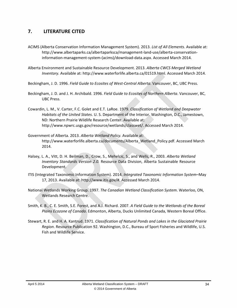
April 5 2014 Alberta Wetland Classification System – DRAFT
© 2014 Government of Alberta
34
7. LITERATURE CITED
ACIMS (Alberta Conservation Information Management System). 2013. List of All Elements. Available at:
http://www.albertaparks.ca/albertaparksca/management‐land‐use/alberta‐conservation‐
information‐management‐system‐(acims)/download‐data.aspx. Accessed March 2014.
Alberta Environment and Sustainable Resource Development. 2013. Alberta CWCS Merged Wetland
Inventory. Available at: http://www.waterforlife.alberta.ca/01519.html. Accessed March 2014.
Beckingham, J. D. 1996. Field Guide to Ecosites of West‐Central Alberta. Vancouver, BC, UBC Press.
Beckingham, J. D. and J. H. Archibald. 1996. Field Guide to Ecosites of Northern Alberta. Vancouver, BC,
UBC Press.
Cowardin, L. M., V. Carter, F.C. Golet and E.T. LaRoe. 1979. Classification of Wetland and Deepwater
Habitats of the United States. U. S. Department of the Interior. Washington, D.C., Jamestown,
ND: Northern Prairie Wildlife Research Center. Available at:
http://www.npwrc.usgs.gov/resource/wetlands/classwet/. Accessed March 2014.
Government of Alberta. 2013. Alberta Wetland Policy. Available at:
http://www.waterforlife.alberta.ca/documents/Alberta_Wetland_Policy.pdf. Accessed March
2014.
Halsey, L. A., Vitt, D. H. Beilman, D., Crow, S., Mehelcic, S., and Wells, R., 2003. Alberta Wetland Inventory Standards Version 2.0. Resource Data Division, Alberta Sustainable Resource Development.
ITIS (Integrated Taxonomic Information System). 2014. Integrated Taxonomic Information System–May
17, 2013. Available at: http://www.itis.gov/#. Accessed March 2014.
National Wetlands Working Group. 1997. The Canadian Wetland Classification System. Waterloo, ON,
Wetlands Research Centre.
Smith, K. B., C. E. Smith, S.E. Forest, and A.J. Richard. 2007. A Field Guide to the Wetlands of the Boreal
Plains Ecozone of Canada. Edmonton, Alberta, Ducks Unlimited Canada, Western Boreal Office.
Stewart, R. E. and H. A. Kantrud. 1971. Classification of Natural Ponds and Lakes in the Glaciated Prairie
Region. Resource Publication 92. Washington, D.C., Bureau of Sport Fisheries and Wildlife, U.S.
Fish and Wildlife Service.

Alberta Wetland Classification System
April 5 2014 Alberta Wetland Classification System - DRAFT
© 2014 Government of Alberta
A-1
COMPARING THE ALBERTA WETLAND CLASSIFICATION SYSTEM TO OTHER WETLAND Appendix ACLASSIFICATIONS AND INVENTORIES
AB Wetland Classification (Class and Form)
Cowardin et. al. 1979 National Wetlands Working Group 1998
Smith et al. 2007 Steward & Kantrud, 1971) (Halsey et. al., 2003)
Wooded Bog Palustrine, Forested or Scrub‐shrub, Needleleaf Evergreen
Bogs (20 Forms and Subforms)
Treed Bog Not described Bog, Forested/ Treed
Shrubby Bog Palustrine, Scrub/ Shrub, Broad‐leaved Evergreen; Needle‐leaved Evergreen
Bogs (20 Forms and Subforms)
Shrubby Bog Not described Bog Open‐Shrub
Wooded Fen Palustrine, Forested or Scrub‐shrub, Needle‐leaved Deciduous, Needle‐leaved Evergreen
Fens (19 Forms and Subforms)
Treed Rich Fen, Treed Poor Fen
Not described Fen, Forested/ Treed
Shrubby Fen Palustrine, Scrub‐shrub, Needle‐leaved Deciduous/ Evergreen or Broad‐leaved Deciduous (Shrub) or Moss
Fens (19 Forms and Subforms)
Shrubby Rich Fen, Shrubby Poor Fen
Not described Fen, Open‐Shrub
Graminoid Fen Palustrine, Emergent/ Persistent, Moss/Lichen
Fens (19 Forms and Subforms)
Graminoid Rich Fen, Graminoid Poor Fen
Class VII Fen, Open‐Graminoid
Graminoid Marsh Palustrine, Emergent or Persistent or Non‐persistent
Marshes (26 Forms and Subforms)
Emergent Marsh Class II to VI; emergent or drawdown phase
Marsh, Open‐Graminoid
Submersed/Floating Shallow Open Water
Palustrine, Emergent or Persistent or Non‐persistent
Shallow Open Water (29forms and Subforms)
Shallow Open Water Class III to V; open water phase
Shallow Open Water ‐ Open
Coniferous Wooded Swamp
Palustrine, Forested, Needle‐leaved Evergreen; Palustrine, Forested, Needle‐leaved Deciduous
Swamps (26 Forms and Subforms)
Conifer Swamp, Tamarack Swamp
Not described Swamp, Forested/ Treed
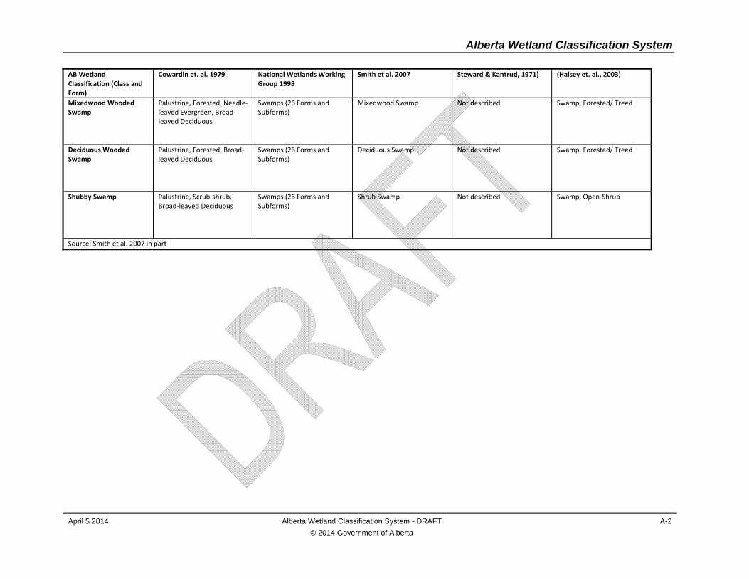
Alberta Wetland Classification System
April 5 2014 Alberta Wetland Classification System - DRAFT
© 2014 Government of Alberta
A-2
AB Wetland Classification (Class and Form)
Cowardin et. al. 1979 National Wetlands Working Group 1998
Smith et al. 2007 Steward & Kantrud, 1971) (Halsey et. al., 2003)
Mixedwood Wooded Swamp
Palustrine, Forested, Needle‐leaved Evergreen, Broad‐leaved Deciduous
Swamps (26 Forms and Subforms)
Mixedwood Swamp Not described Swamp, Forested/ Treed
Deciduous Wooded Swamp
Palustrine, Forested, Broad‐leaved Deciduous
Swamps (26 Forms and Subforms)
Deciduous Swamp Not described Swamp, Forested/ Treed
Shubby Swamp Palustrine, Scrub‐shrub, Broad‐leaved Deciduous
Swamps (26 Forms and Subforms)
Shrub Swamp Not described Swamp, Open‐Shrub
Source: Smith et al. 2007 in part
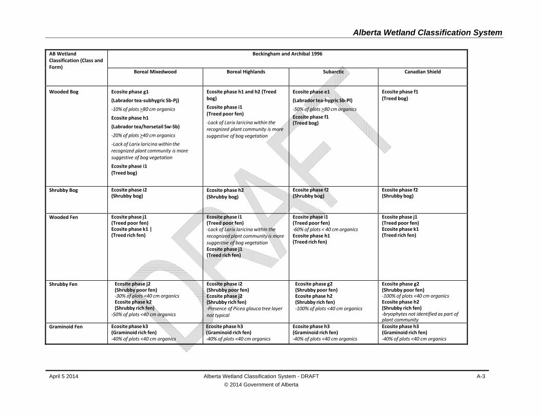
Alberta Wetland Classification System
April 5 2014 Alberta Wetland Classification System - DRAFT
© 2014 Government of Alberta
A-3
AB Wetland Classification (Class and Form)
Beckingham and Archibal 1996
Boreal Mixedwood Boreal Highlands Subarctic Canadian Shield
Wooded Bog Ecosite phase g1
(Labrador tea‐subhygric Sb‐Pj)
‐10% of plots >80 cm organics
Ecosite phase h1
(Labrador tea/horsetail Sw‐Sb)
‐20% of plots >40 cm organics
‐Lack of Larix laricina within the recognized plant community is more suggestive of bog vegetation
Ecosite phase i1 (Treed bog)
Ecosite phase h1 and h2 (Treed bog)
Ecosite phase i1 (Treed poor fen)
‐Lack of Larix laricina within the recognized plant community is more suggestive of bog vegetation
Ecosite phase e1
(Labrador tea‐hygric Sb‐Pl)
‐50% of plots >80 cm organics
Ecosite phase f1 (Treed bog)
Ecosite phase f1 (Treed bog)
Shrubby Bog Ecosite phase i2 (Shrubby bog)
Ecosite phase h2 (Shrubby bog)
Ecosite phase f2 (Shrubby bog)
Ecosite phase f2 (Shrubby bog)
Wooded Fen Ecosite phase j1 (Treed poor fen) Ecosite phase k1 | (Treed rich fen)
Ecosite phase i1 (Treed poor fen) ‐Lack of Larix laricina within the recognized plant community is more suggestive of bog vegetation Ecosite phase j1 (Treed rich fen)
Ecosite phase i1 (Treed poor fen) ‐60% of plots < 40 cm organics Ecosite phase h1 (Treed rich fen)
Ecosite phase j1 (Treed poor fen) Ecosite phase k1 (Treed rich fen)
Shrubby Fen Ecosite phase j2 (Shrubby poor fen) ‐30% of plots <40 cm organics Ecosite phase k2 (Shrubby rich fen)
‐50% of plots <40 cm organics
Ecosite phase i2 (Shrubby poor fen) Ecosite phase j2 (Shrubby rich fen) ‐Presence of Picea glauca tree layer not typical
Ecosite phase g2 (Shrubby poor fen) Ecosite phase h2 (Shrubby rich fen) ‐100% of plots <40 cm organics
Ecosite phase g2 (Shrubby poor fen) ‐100% of plots <40 cm organics Ecosite phase h2 (Shrubby rich fen) ‐bryophytes not identified as part of plant community
Graminoid Fen Ecosite phase k3 (Graminoid rich fen) ‐40% of plots <40 cm organics
Ecosite phase h3 (Graminoid rich fen) ‐40% of plots <40 cm organics
Ecosite phase h3 (Graminoid rich fen) ‐40% of plots <40 cm organics
Ecosite phase h3 (Graminoid rich fen) ‐40% of plots <40 cm organics

Alberta Wetland Classification System
April 5 2014 Alberta Wetland Classification System - DRAFT
© 2014 Government of Alberta
A-4
AB Wetland Classification (Class and Form)
Beckingham and Archibal 1996
Boreal Mixedwood Boreal Highlands Subarctic Canadian Shield
Graminoid Marsh Ecosite phase k3 (Graminoid rich fen) ‐40% of plots have <40 cm organics Ecosite phase l1 (Marsh)
Ecosite phase h3 (Graminoid rich fen) ‐40% of plots <40 cm organics
Ecosite phase h3 (Graminoid rich fen) ‐40% of plots <40 cm organics
Ecosite phase h3 (Graminoid rich fen) ‐40% of plots <40 cm organics
Submersed/Floating Shallow Open Water
Not recognized Not recognized Not recognized Not recognized
Coniferous Wooded Swamp
Ecosite phase g1
(Labrador tea‐subhygric Sb‐Pj)
‐10% of plots have >80 cm organics
Ecosite phase h1
(Labrador tea/horsetail Sw‐Sb)
‐20% of plots have >40 cm organics
‐Lack of Larix laricina within the recognized plant community is more suggestive of bog vegetation
Ecosite phase f3 (White spruce (Sw)/ /horsetail)
Ecosite phase f1 (Horsetail Sw) ‐
Ecosite phase d3 (HorsetailSw)
Not recognized
Mixedwood Wooded Swamp
Ecosite Phase f2 (Balsam poplar (Pb)–white spruce (Sw) /Horsetail)
Ecosite phase g1(Labrador tea‐hygric Sb‐Pj)
Ecosite phase e1 (Labrador tea‐hygric Sb‐Pl) ‐50% of plots have >80 cm organics Ecosite phase d2 (Horsetail Aw‐Sw)
Ecosite phase e2 (Willow/horsetailAw‐Sw‐Sb
Deciduous Wooded Swamp
Ecosite phase f1 (Horsetail Pb‐Aw)
Not recognized Ecosite phase d1 (Horsetail Pb‐Bw)
Ecosite phase e1 (Willow/horsetailAw‐Bw‐Pb)
Shubby Swamp Ecosite phase j2 (Shrubby poor fen) ‐30% of plots <40 cm organics Ecosite phase k2 (Shrubby rich fen)
‐50% of plots <40 cm organics
Not recognized Ecosite phase h2 (Shrubby rich fen) ‐100% of plots have <40 cm organics
Ecosite phase g2 (Shrubby poor fen) ‐100% of plots <40 cm organics Ecosite phase h2 (Shrubby rich fen)
Source: Halsey et al. 2003

April 5 2014 Alberta Wetland Classification System - DRAFT
© 2014 Government of Alberta
B-1
VON POST DECOMPOSITION SCALE Appendix B
The von Post decomposition scale is a field test for determining the degree of organic matter
decomposition. The test is completed by taking a handful of organic matter and squeezing it. The extent
of decomposition is determined by the nature of the liquid that is squeezed from the organic matter,
how much organic matter remains in the hand after the organic matter has been squeezed, and the
nature of the plant matter. A von Post result of 5 or less indicates peat.
Degree of Decomposition
Nature of Squeezed Liquid
Properties of Organic Mater Extruded
Nature of Plant Matter
Description
1 Clear, colourless None Plant structure unaltered
Undecomposed
2 Almost clear, yellow‐brown
None Plant structure distinct, almost unaltered
Almost undecomposed
3 Slightly turbid, brown None Plant structure distinct, most remains easily identifiable
Very weakly decomposed
4 Strongly turbid, brown None Plant structure distinct, most remains identifiable
Weakly decomposed
5 Strongly turbid, contains little organic material in suspension
Very little Plant structure clear but indistinct and difficult to identify
Moderately decomposed
6 Muddy, much organic material in suspension
One third Plant structure indistinct, with most undefinable
Well decomposed
7 Strongly muddy One half Plant structure indistinct
Strongly decomposed
8 Thick mud, little free water
Two thirds Plant structure very indistinct with only resistant material such as roots identifiable
Very strongly decomposed
9 No free water Nearly all Plant structure almost unrecognizable
Almost completely decomposed
10 No free water All Plant structure not recognizable, amorphous
Completely decomposed
Adapted from Agriculture and Agri‐Foods Canada 2013. The Canadian System of Soil Classification, 3rd edition.
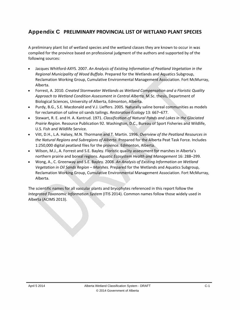
April 5 2014 Alberta Wetland Classification System - DRAFT
© 2014 Government of Alberta
C-1
PRELIMINARY PROVINCIAL LIST OF WETLAND PLANT SPECIES Appendix C
A preliminary plant list of wetland species and the wetland classes they are known to occur in was
compiled for the province based on professional judgment of the authors and supported by of the
following sources:
Jacques Whitford‐AXYS. 2007. An Analysis of Existing Information of Peatland Vegetation in the
Regional Municipality of Wood Buffalo. Prepared for the Wetlands and Aquatics Subgroup,
Reclamation Working Group, Cumulative Environmental Management Association. Fort McMurray,
Alberta.
Forrest, A. 2010. Created Stormwater Wetlands as Wetland Compensation and a Floristic Quality
Approach to Wetland Condition Assessment in Central Alberta. M.Sc. thesis, Department of
Biological Sciences, University of Alberta, Edmonton, Alberta.
Purdy, B.G., S.E. Macdonald and V.J. Lieffers. 2005. Naturally saline boreal communities as models
for reclamation of saline oil sands tailings. Restoration Ecology 13: 667–677.
Stewart, R. E. and H. A. Kantrud. 1971. Classification of Natural Ponds and Lakes in the Glaciated
Prairie Region. Resource Publication 92. Washington, D.C., Bureau of Sport Fisheries and Wildlife,
U.S. Fish and Wildlife Service.
Vitt, D.H., L.A. Halsey, M.N. Thormann and T. Martin. 1996. Overview of the Peatland Resources in
the Natural Regions and Subregions of Alberta. Prepared for the Alberta Peat Task Force. Includes
1:250,000 digital peatland files for the province. Edmonton, Alberta.
Wilson, M.J., A. Forrest and S.E. Bayley. Floristic quality assessment for marshes in Alberta’s
northern prairie and boreal regions. Aquatic Ecosystem Health and Management 16: 288–299.
Wong, A., C. Greenway and S.E. Bayley. 2008. An Analysis of Existing Information on Wetland
Vegetation in Oil Sands Region – Marshes. Prepared for the Wetlands and Aquatics Subgroup,
Reclamation Working Group, Cumulative Environmental Management Association. Fort McMurray,
Alberta.
The scientific names for all vascular plants and bryophytes referenced in this report follow the
Integrated Taxonomic Information System (ITIS 2014). Common names follow those widely used in
Alberta (ACIMS 2013).

NOTES:1 B = bog, F = fen; M = marsh; W = shallow open water; and S = swamp
April 5 2014 Alberta Wetland Classification System - DRAFT
© 2014 Government of Alberta
C-2
Scientific Name –ITIS (2014)
Common Name ACMIS (2103)
Wetland Classes1
TREES
Betula neoalaskana Sarg. Alaska birch S
Betula papyrifera Marshall white birch S
Larix laricina (Du Roi) K. Koch tamarack F, S
Picea mariana (Mill.) BSP. black spruce B, F, S
Populus angustifolia James narrow‐leaf cottonwood S
Populus balsamifera L. balsam poplar S
Populus deltoides Marshall plains cottonwood S
SHRUBS
Alnus incana (L.) Moench alder S
Alnus viridis (Vill.) Lam. & DC. green alder S
Andromeda polifolia L. bog rosemary B, F, S
Betula nana L. bog birch F
Betula glandulosa Michx. bog birch F
Betula occidentalis Hook. water birch F, S
Betula pumila L. dwarf birch B, F, S
Chamaedaphne calyculata (L.) Moench leatherleaf B, F
Cornus sericea L. red‐osier dogwood S
Elaeagnus commutata Bernh. ex Rydb. silverberry S
Empetrum nigrum L. crowberry B, F
Gaultheria hispidula (L.) Muhl. ex Bigelow creeping snowberry S
Kalmia microphylla (Hook.) A. Heller mountain laurel B
Kalmia polifolia Wang. northern laurel B, S
Linnaea borealis L. twinflower B, S
Lonicera caerulea L. fly honeysuckle B, S
Lonicera dioica L. twining honeysuckle S
Lonicera involucrata (Richardson) Banks brackted honeysuckle F, S
Lycopodium annotinum L. stiff club‐moss B
Myrica gale L. sweet gale F, S
Prunus virginiana L. choke cherry S
Rhamnus alnifolia L'Her. alder‐leaved buckthorn F, S
Rhododendron groenlandicum Oeder common Labrador tea B, F, S
Rhododendron tomentosum Harmaja northern Labrador tea B
Ribes americanum P. Mill. wild black currant S
Ribes glandulosum Grauer skunk currant S
Ribes hudsonianum Richards. northern black currant F, S
Ribes lacustre (Pers.) Poir. bristly black currant F, S
Ribes triste Pall. wild red currant S
Rubus idaeus L. wild red raspberry B, S
Salix arbusculoides Andersson shrubby willow F, S
Salix bebbiana Sarg. Bebb willow F, S
Salix candida Flüggé ex Willd. hoary willow F, S
Salix discolor Muhl. pussy willow F, S
Salix exigua Nutt. sandbar willow F, S

NOTES:1 B = bog, F = fen; M = marsh; W = shallow open water; and S = swamp
April 5 2014 Alberta Wetland Classification System - DRAFT
© 2014 Government of Alberta
C-3
Scientific Name –ITIS (2014)
Common Name ACMIS (2103)
Wetland Classes1
Salix glauca L. smooth willow F, S
Salix lucida Muhl. shiny willow F, S
Salix maccalliana Rowlee velvet‐fruited willow F, S
Salix pedicellaris Pursh bog willow F, S
Salix petiolaris J.E. Sm. basket willow F
Salix planifolia Pursh flat‐leaved willow F, S
Salix pyrifolia Andersson balsam willow F, S
Salix scouleriana Barratt ex Hook. Scouler willow F, S
Salix serissima (Bailey) Fernald autumn willow F
Sambucus racemosa L. red elderberry S
Sarcobatus vermiculatus (Hook.) Torr. greasewood M
Spiraea alba Du Roi narrow‐leaved meadowsweet F, S
Vaccinium oxycoccos L. small bog cranberry B, F, S
Vaccinium vitis‐idaea L. bog cranberry B, F. M, S
Viburnum edule (Michx.) Raf. low‐bush cranberry S
Viburnum opulus var. americanum Aiton high bush‐cranberry F, S
FORBS AND PTERIDOPHYTES
Achillea millefolium L. common yarrow M, S
Actaea rubra (Ait.) Willd. red and white baneberry S
Adoxa moschatellina L. moschatel S
Agrimonia striata Michx. agrimony M
Agoseris glauca (Pursh) Raf. yellow false dandelion M
Alisma gramineum Lej. narrow‐leaved water‐plantain M
Alisma plantago‐aquatica L. broad‐leaved water‐plantain M
Alisma triviale Pursh broad‐leaved water‐plantain M
Allium schoenoprasum L. wild chives M
Almutaster pauciflorus (Nutt.) A. & D. Löve few‐flower aster M, W
Amaranthus retroflexus L. red‐root pigweed M
Ambrosia psilostachya DC perennial ragweed M
Androsace occidentalis Pursh. western fairy candelabra M
Anemone canadensis L. Canada anemone M, S
Anemone quinquefolia L. wood anemone S
Apocynum cannabinum L. Indian hemp M
Aralia nudicaulis L. wild sarsaparilla S
Arnica chamissonis Less. leafy arnica F, M, W
Artemisia biennis Willd. biennial sagewort M
Artemisia ludoviciana Nutt. prairie sagewort M
Astragalus alpinus L. alpine milk vetch M
Astragalus americanus (Hook.) M.E. Jones American milk vetch M, S
Astragalus canadensis L. Canadian milk vetch M
Atriplex argentea Nutt. silver saltbrush M, W
Atriplex micrantha Ledeb. saltbush M
Atriplex powellii S. Wats. Powell's saltbush M
Atriplex prostrata Bouchér ex DC. prostrate saltbush M

NOTES:1 B = bog, F = fen; M = marsh; W = shallow open water; and S = swamp
April 5 2014 Alberta Wetland Classification System - DRAFT
© 2014 Government of Alberta
C-4
Scientific Name –ITIS (2014)
Common Name ACMIS (2103)
Wetland Classes1
Atriplex subspicata (Nutt.) Rydb. spearscale saltbush M, W
Atriplex truncata (Torr. ex S. Wats.) A. Gray saltbush M, W
Bacopa rotundifolia (Michx.) Wettst. water hyssop M
Barbarea orthoceras Ledeb. American winter cress M
Bidens cernua L. nodding beggarticks M, S
Bidens frondosa L. common beggarticks M
Bistorta vivipara (L.) Delarbre alpine bistort M
Brasenia schreberi J.F. Gmel. watershield F, M, W
Calla palustris L. water arum F, M, S
Callitriche hermaphroditica L. northern water‐starwort M, W
Callitriche palustris L. vernal water‐starwort F, M
Caltha natans Pall. ex Georgi floating marsh‐marigold F, M, W
Caltha palustris L. marsh marigold M, S
Canadanthus modestus (Lindl.) Nesom large northern aster F, M
Capsella bursa‐pastoris (L.) Medik. shepherd's purse M
Cardamine pensylvanica Muhl. ex Willd. bittercress M, S
Cardamine pratensis L. meadow bitter cress M
Castilleja raupii Pennell purple paintbrush M
Cerastium arvense L. field mouse‐ear chickweed M
Chamerion angustifolium ssp. angustifolium (L.) Holub common fireweed M, S
Chamerion latifolium (L.) Holub broad‐leaved fireweed M, F
Chenopodium album L. lamb's quarters M
Chenopodium capitatum (L.) Ambrosi strawberry blite M
Chenopodium rubrum L. red goosefoot M
Chenopodium salinum Standl. oak‐leaved goosefoot M
Chenopodium glaucum var. salinum (Standl.) B. Boivin oak‐leaved goosefoot F, M. S
Chrysosplenium iowense Rybd. golden saxifrage F, M
Chrysosplenium tetrandrum Th. Fr. green saxifrage F, M
Cicuta bulbifera L. bulb‐bearing water‐hemlock F, M, S
Cicuta maculata L. water‐hemlock F, M, S
Cicuta virosa L. narrow‐leaved water‐hemlock M
Cinna latifolia (Trevir. ex. Gopp) Griseb drooping wood‐reed M
Circaea alpina L. small enchanter's nightshade S
Cirsium arvense (L.) Scop. creeping thistle M, S
Coeloglossum viride (L.) Hartm. bracted bog orchid M
Comarum palustre L. marsh cinquefoil B, F, M, S
Conium maculatum L. poison hemlock M
Corallorhiza trifida Chat pale coralroot F, S
Conyza canadensis (L.) Cronquist horseweed M
Coptis trifolia (L.) Salisb. goldthread M, S
Corydalis aurea Willd. golden corydalis M
Cornus canadensis L. bunchberry S
Crepis runcinata (James) T. & G. scapose hawk’s‐beard M
Crepis tectorum L. annual hawk's‐beard M

NOTES:1 B = bog, F = fen; M = marsh; W = shallow open water; and S = swamp
April 5 2014 Alberta Wetland Classification System - DRAFT
© 2014 Government of Alberta
C-5
Scientific Name –ITIS (2014)
Common Name ACMIS (2103)
Wetland Classes1
Cyclachaena xanthifolia (Nutt.) Fresen false ragweed F, M, W
Cypripedium acaule Ait. stemless lady's‐slipper B, S
Cypripedium parviflorum Salisb. yellow lady's‐slipper M
Delphinium glaucum S. Wats. tall larkspur M, S
Descurainia sophia (L.) Webb ex Prantl flixweed M
Dracocephalum parviflorum Nutt. American dragonhead M
Drosera anglica Huds. great sundew B, F
Drosera linearis Goldie slender‐leaved sundew B, F, S
Drosera rotundifolia L. round‐leafed sundew B, F, S
Dryopteris carthusiana (Vill.) H.P. Fuchs narrow spinulose shield fern S
Dryopteris cristata (L.) A. Gray crested shield fern S
Elatine triandra Schkuhr. waterwort M
Ellisia nyctelea (L.) L. waterpod M
Elodea bifoliata H. St. John two‐leaf waterweed F, M
Elodea canadensis Mitchx. Canada waterweed M, W
Epilobium ciliatum Raf. northern willowherb B, F, M, S
Epilobium leptophyllum Raf. narrow‐leaved willowherb B, F, M, S
Epilobium palustre L marsh willowherb F, M, S
Epilobium campestre (Jeps.) Hoch & W.L. Wagner smooth boisduvalia F, M. W
Equisetum arvense L. common horsetail B, F, M, S
Equisetum fluviatile L. swamp horsetail B, F, M, S
Equisetum hyemale L. common scouring‐rush M
Equisetum laevigatum A. Br. smooth scouring‐rush M
Equisetum palustre L. marsh horsetail B, F, M, S
Equisetum pratense Ehrh. meadow horsetail F, M, S
Equisetum scirpoides Michx. dwarf scouring‐rush B, F, M, S
Equisetum sylvaticum L. woodland horsetail B, M, S
Equisetum variegatum Schleich. variegated horsetail M, S
Eriogonum androsaceum Benth. cushion umbrella‐plant F
Erigeron acris L. northern daisyfleabane M
Erigeron elatus (Hook.) Greene tall fleabane M
Erigeron lonchophyllus Hook. fleabane M
Erigeron philadelphicus L. Philadelphia fleabane M, S
Erysimum cheiranthoides L. wormseed mustard M
Eutrochium maculatum (L.) E.E. Lamont spotted Joe‐pye weed S, M
Eurybia sibirica (L.) Nesom Arctic aster M
Euthamia graminifolia (L.) Nutt. flat‐topped goldenrod M
Fallopia convolvulus (L.) Á. Löve wild buckwheat F, M, W
Fragaria vesca L. woodland strawberry M
Fragaria virginiana Duchesne wild strawberry M
Galearis rotundifolia (Banks ex Pursh) R.M. Bateman round‐leaved orchid S
Galeopsis tetrahit L. hemp‐nettle F, M
Galium boreale L. northern bedstraw B, S
Galium labradoricum (Wiegand) Wiegand northern bog bedstraw B, F, M, S
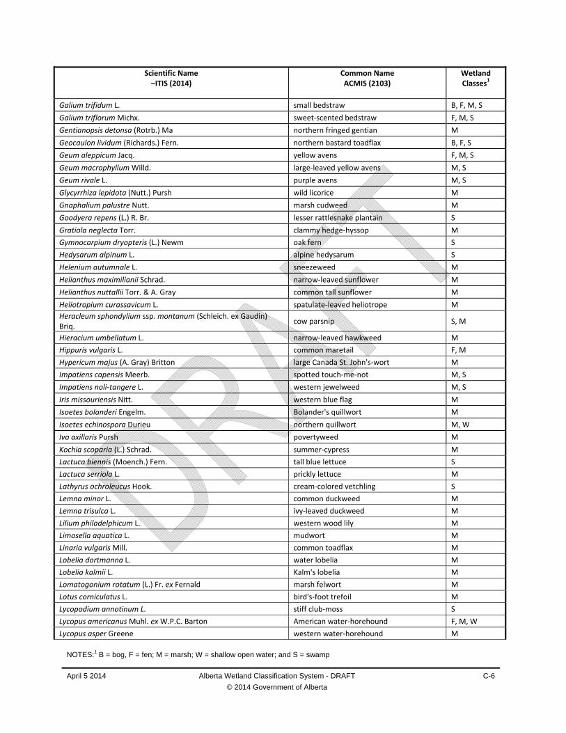
NOTES:1 B = bog, F = fen; M = marsh; W = shallow open water; and S = swamp
April 5 2014 Alberta Wetland Classification System - DRAFT
© 2014 Government of Alberta
C-6
Scientific Name –ITIS (2014)
Common Name ACMIS (2103)
Wetland Classes1
Galium trifidum L. small bedstraw B, F, M, S
Galium triflorum Michx. sweet‐scented bedstraw F, M, S
Gentianopsis detonsa (Rotrb.) Ma northern fringed gentian M
Geocaulon lividum (Richards.) Fern. northern bastard toadflax B, F, S
Geum aleppicum Jacq. yellow avens F, M, S
Geum macrophyllum Willd. large‐leaved yellow avens M, S
Geum rivale L. purple avens M, S
Glycyrrhiza lepidota (Nutt.) Pursh wild licorice M
Gnaphalium palustre Nutt. marsh cudweed M
Goodyera repens (L.) R. Br. lesser rattlesnake plantain S
Gratiola neglecta Torr. clammy hedge‐hyssop M
Gymnocarpium dryopteris (L.) Newm oak fern S
Hedysarum alpinum L. alpine hedysarum S
Helenium autumnale L. sneezeweed M
Helianthus maximilianii Schrad. narrow‐leaved sunflower M
Helianthus nuttallii Torr. & A. Gray common tall sunflower M
Heliotropium curassavicum L. spatulate‐leaved heliotrope M
Heracleum sphondylium ssp. montanum (Schleich. ex Gaudin) Briq.
cow parsnip S, M
Hieracium umbellatum L. narrow‐leaved hawkweed M
Hippuris vulgaris L. common maretail F, M
Hypericum majus (A. Gray) Britton large Canada St. John's‐wort M
Impatiens capensis Meerb. spotted touch‐me‐not M, S
Impatiens noli‐tangere L. western jewelweed M, S
Iris missouriensis Nitt. western blue flag M
Isoetes bolanderi Engelm. Bolander's quillwort M
Isoetes echinospora Durieu northern quillwort M, W
Iva axillaris Pursh povertyweed M
Kochia scoparia (L.) Schrad. summer‐cypress M
Lactuca biennis (Moench.) Fern. tall blue lettuce S
Lactuca serriola L. prickly lettuce M
Lathyrus ochroleucus Hook. cream‐colored vetchling S
Lemna minor L. common duckweed M
Lemna trisulca L. ivy‐leaved duckweed M
Lilium philadelphicum L. western wood lily M
Limosella aquatica L. mudwort M
Linaria vulgaris Mill. common toadflax M
Lobelia dortmanna L. water lobelia M
Lobelia kalmii L. Kalm's lobelia M
Lomatogonium rotatum (L.) Fr. ex Fernald marsh felwort M
Lotus corniculatus L. bird's‐foot trefoil M
Lycopodium annotinum L. stiff club‐moss S
Lycopus americanus Muhl. ex W.P.C. Barton American water‐horehound F, M, W
Lycopus asper Greene western water‐horehound M

NOTES:1 B = bog, F = fen; M = marsh; W = shallow open water; and S = swamp
April 5 2014 Alberta Wetland Classification System - DRAFT
© 2014 Government of Alberta
C-7
Scientific Name –ITIS (2014)
Common Name ACMIS (2103)
Wetland Classes1
Lycopus uniflorus Michx. northern water‐horehound B, M, S
Lysimachia hybrida Michx. lance‐leaved loosestrife M
Lysimachia lanceolata Walter lance‐leaved loosestrife M
Lysimachia maritima (L.) Galasso, Banfi & Soldano sea milkwort F, M
Lysimachia thyrsiflora L. tufted loosestrife B, F, M, S
Lythrum salicaria L. purple loosestrife F, M
Maianthemum canadense Desf. wild lily‐of‐the‐valley S
Maianthemum stellatum (L.) Link star‐flowered Solomon's‐seal M, S
Maianthemum trifolium (L.) Sloboda three‐leafed Solomon’s‐plume B, F, M, S
Marsilea vestita Hook. & Grev. hairy pepperwort M, W
Matricaria discoidea DC pineappleweed M
Matteuccia struthiopteris (L.) Tod. ostrich fern M, S
Melilotus albus Medik white sweet‐clover M
Melilotus officinalis (L.) Lam yellow sweet‐clover M
Mentha arvensis L. wild mint M, S
Mentha spicata L. spearmint M
Menyanthes trifoliata L. buck‐bean F, S
Mertensia paniculata (Ait.) G. Don tall lungwort S
Mitella nuda L. bishop's‐cap B, F, M, S
Moehringia lateriflora (L.) Fenzl. blunt‐leaved sandwort S
Moneses uniflora (L.) A. Gray one‐flowered wintergreen B, S
Monolepis nuttalliana (Schult.) Greene spear‐leaved goosefoot F, M, W
Mulgedium oblongifolium (Nutt.) Reveal blue lettuce M
Muhlenbergia richardsonis (Trin.) Rydb. mat muhly M
Myriophyllum sibiricum Kom. spike water‐milfoil M, W
Myriophyllum verticillatum L. water‐milfoil F, M, W
Najas flexilis (Willd.) Rostk. & W.L.E. Schmidt slender naiad M
Nasturtium officinale W.T. Alton water cress M
Neottia cordata (L.) Rich. heart‐leaved twayblade S
Nuphar lutea (L.) Sm. yellow pond‐lily F, M
Nymphaea tetragona Georgi white water‐lily F, M
Orthilia secunda (L.) House one‐sided wintergreen B, F, S
Osmorhiza longistylis (Torr.) DC. smooth sweet cicely S
Packera pauciflora (Pursh) A. & D. Löve few‐flowered ragwort S
Packera paupercula (Michx.) Á. & D. Löve balsam groundsel S
Parnassia palustris L. marsh grass‐of‐Parnassus B, F, M, S
Pedicularis groenlandica Retz. elaphant's‐head M
Pedicularis labradorica Wirsing Labrador lousewort B
Pedicularis macrodonta Richardson muskeg lousewort B, F, M
Pedicularis parviflora J.E. Smith swamp lousewort B, F, M
Penstemon procerus Dougl. slender blue beardtongue F
Persicaria amphibia (L.) Delarbre water smartweed M, S
Persicaria lapathifolia (L.) Gray pale persicaria F, M, W
Petasites frigidus var frigidus (L.) Fr. sweet coltsfoot M

NOTES:1 B = bog, F = fen; M = marsh; W = shallow open water; and S = swamp
April 5 2014 Alberta Wetland Classification System - DRAFT
© 2014 Government of Alberta
C-8
Scientific Name –ITIS (2014)
Common Name ACMIS (2103)
Wetland Classes1
Petasites frigidus var. palmatus (Aiton) Cronquist palmate‐leaved coltsfoot M, S
Petasites frigidus var. sagittatus (Banks ex Pursh) Chern. arrow‐leaved coltsfoot F, M, S
Petasites frigidus var x vitifolius (Greene) Chern vine‐leaved coltsfoot M
Phragmites australis (Cav.) Trin. ex Steud. reed S
Physostegia parviflora Nutt ex.Gray false dragonhead M
Pinguicula villosa L. small butterwort B
Plagiobothrys scouleri (Hook.&Arn.) I.M. Johnst. Scouler's allocarya M
Plantago eriopoda Torr. saline plantain M
Plantago maritima L. sea‐side plantain F, M
Platanthera dilatata (Pursh) Lindl. tall white bog orchid B, F
Platanthera dilatata var. dilatata (Pursh) Lindl. ex L.C. Beck tall white bog orchid S
Platanthera hyperborea (L.) Lindl. northern green bog orchid B, F, M, S
Platanthera obtusata ssp. obtusata (Banks ex Pursh) Lindl. blunt‐leaved bog orchid F, S
Platanthera orbiculata (Pursh) Lindl. round‐leaved bog orchid S
Polemonium acutiflorum Willd. ex.Roem & Schult. tall Jacob's‐ladder M
Polygala paucifolia Willd. fringed milkwort S
Polygonum achoreum S.F. Blake striate knotweed F, M
Polygonum erectum L. striate knotweed M
Polygonum ramosissimum Michx. bushy knotweed M
Potamogeton foliosus Raf. leafy pondweed F, M, W
Potamogeton friesii Rupr. Fries’ pondweed F, M, W
Potamogeton gramineus L. various‐leaved pondweed M, W
Potamogeton natans L. floating‐leaf pondweed F, M, W
Potamogeton praelongus Wulf. white‐stem pondweed F, M, W
Potamogeton pusillus L. small‐leaf pondweed W
Potamogeton richardsonii (A. Benn.) Rydb. clasping‐leaf pondweed M
Potamogeton zosteriformis Fernald flat‐stemmed pondweed F, M, W
Potentilla anserina L. silverweed F, M
Potentilla gracilis Douglas ex. Hook. graceful cinquefoil M
Potentilla norvegica L. rough cinquefoil M, S
Potentilla rivalis Nutt. brook cinquefoil M
Primula incana M.E. Jones mealy primrose M
Primula pauciflora var. pauciflora (Greene) A.R. Mast & Reveal pretty shooting star B, M, S
Pyrola minor L. lesser wintergreen F, S
Ranunculus abortivus L. small‐flowered buttercup M, S
Ranunculus acris L. tall buttercup M
Ranunculus aquatilis var. diffusus With. large‐leaved white water crowfoot M, W
Ranunculus cymbalaria Pursh seaside buttercup M
Ranunculus flammula L. creeping spearwort F, M, W
Ranunculus gmelinii De Candolle yellow water crowfoot B, F, M, S
Ranunculus lapponicus L. Lapland buttercup M, S
Ranunculus macounii Britt. Macoun's buttercup F, M
Ranunculus pensylvanicus L. f. bristly buttercup F, M, W
Ranunculus sceleratus L. celery‐leaved buttercup M

NOTES:1 B = bog, F = fen; M = marsh; W = shallow open water; and S = swamp
April 5 2014 Alberta Wetland Classification System - DRAFT
© 2014 Government of Alberta
C-9
Scientific Name –ITIS (2014)
Common Name ACMIS (2103)
Wetland Classes1
Rorippa palustris (L.) Besser marsh yellow cress B, F, M, W
Rubus arcticus L. dwarf‐raspberry B, F, M, S
Rubus chamaemorus L. cloudberry B, F, S
Rubus pubescens Raf. dewberry B, F, M, S
Rumex britannica L. water dock M, S
Rumex crispus L. curled dock M, S
Rumex maritimus L. golden dock F, M, W
Rumex triangulivalvis (Danser) Rech. f. narrow‐leaved field dock M
Ruppia cirrhosa (Petagna) Grande widgeon‐grass M, W
Sagittaria cuneata E. Sheld. arum‐leaved arrowhead M
Sagittaria latifolia Willd. broad‐leaved arrowhead M
Salicornia rubra A. Nels. samphire M
Solidago gigantea Aiton late goldenrod M
Salsola kali L. Russian‐thistle M
Sanicula marilandica L. snakeroot S
Sarracenia purpurea L. pitcher‐plant B, F, S
Scheuchzeria palustris L. scheuchzeria B, F
Scutellaria galericulata L. marsh skullcap M, S
Senecio eremophilus Richardson cut‐leaved ragwort M
Sinapis arvensis L. wild mustard M
Sisyrinchium montanum Greene common blue‐eyed grass F, M, W
Sium suave Walter common waterparsnip F, M
Solidago canadensis L. Canada goldenrod M, S
Sonchus arvensis L. perennial sow‐thistle M, S
Sonchus asper (L.) Hill prickly annual sow‐thistle M
Sparganium angustifolium Michx. narrow‐leaved bur‐reed F, M, W
Sparganium eurycarpum Engelm. ex A. Gray giant burreed M
Sparganium natans L. slender bur‐reed M
Spergularia salina J. & C. Presl salt‐marsh sand spurry B, F, M
Spiranthes romanzoffiana Cham. hooded ladies'‐tresses B, F, M, S
Stachys palustris L. Marsh hedge‐nettle M
Stellaria calycantha (Ledeb.) Bong. northern stitchwort F, M, S, W
Stellaria crassifolia Ehrh. thick‐leaf starwort F, M
Stellaria longifolia Muhl. ex Willd. long‐leafed chickweed B, F, M, S
Stellaria longipes Goldie long‐stalked chickweed M
Streptopus lanceolatus var. roseus (Michx.) Reveal rose mandarin S
Stuckenia filiformis (Pers.) Borner thread‐leaved pondweed M
Stuckenia pectinata (L.) Börner sago pondweed M, W
Stuckenia vaginata (Turcz.) Holub large‐sheath pondweed W
Suaeda calceoliformis (Hook.) Moq. common seablite M
Suckleya suckleyana (Torr.) Rydb. poison suckleya F, M, W
Symphyotrichum boreale (Torr. & Gray) A. & D. Löve Marsh aster F, M, W
Symphyotrichum ciliatum (Ledeb.) Nesom rayless aster M
Symphyotrichum ciliolatum (Lindl.) A. Löve & D. Löve Lindley's aster M, S

NOTES:1 B = bog, F = fen; M = marsh; W = shallow open water; and S = swamp
April 5 2014 Alberta Wetland Classification System - DRAFT
© 2014 Government of Alberta
C-10
Scientific Name –ITIS (2014)
Common Name ACMIS (2103)
Wetland Classes1
Symphyotrichum ericoides (L.) G.L. Nesom tufted white prairie aster M
Symphyotrichum lanceolatum (Willd.) Nesom western willow aster M
Symphyotrichum puniceum (L.) Á. Löve & D. Löve purple‐stemmed aster F, M, W
Symphyotrichum puniceum var. puniceum (L.) Á. & D. Löve purple‐stemmed aster M, S
Tanacetum vulgare L. common tansy M
Taraxacum officinale Weber common dandelion M, S
Taraxacum erythospermum Andrz. ex. Besser red‐seeded dandelion M
Tephroseris palustris (L.) Reichenbach marsh ragwort M
Thalictrum dasycarpum Fisch. & Ave‐Lall. tall meadow rue S
Thalictrum venulosum Trel. veiny meadow rue S
Thlaspi arvense L. stinkweed M
Tofieldia glutinosa (Michx.) Baker sticky false asphodel M
Triantha glutinosa (Michx.) Baker sticky false asphodel F, S
Trientalis borealis Raf. northern starflower S, M
Trientalis europaea L. Arctic starflower F, S
Trifolium hybridum L. alsike clover M
Trifolium repens L. white clover M
Triglochin maritima L. seaside arrow‐grass F, M
Triglochin palustris L. slender arrow‐grass F, S, M
Urtica dioica L. common nettle F, S, M
Urtica urens L. small nettle M
Utricularia cornuta Michx. horned bladderwort M, W
Utricularia intermedia Hayne flat‐leafed bladderwort F, M, S, W
Utricularia minor L. small bladderwort F, M, S, W
Utricularia vulgaris L. common bladderwort F, M, W
Valeriana dioica L. northern valerian F, M, W
Veronica americana Schwein. ex Benth. American brooklime M
Veronica anagallis‐aquatica L. speedwell F, M
Veronica peregrina L. hairy speedwell M
Veronica scutellata L. marsh speedwell F, M. W
Vicia americana Muhl. ex Willd. wild vetch F, M, S
Viola sororia var. affinis (Leconte) L.E. McKinney bog violet B, F, M
Viola macloskeyi F.E. Lloyd MacIoskeyi's violet M
Viola palustris L. marsh violet B, M, S
Viola renifolia Gray kidney‐leaved violet F, S
Viola sororia var. affins (Leconte) L.E. McKinney bog violet M
Wolffia borealis (Engelm ex. Hegelm) Landolt northern ducksmeal M, W
Wolffia columbiana H. Karst watermeal M, W
Xanthium strumarium L. cocklebur W
Zannichellia palustris L. horned pondweed M, W
Zizia aptera (A. Gray) Fernald heart‐leaved Alexanders M
Zizania aquatica L. wild rice M, W
GRAMINOIDS
Acorus americanus (Raf.) Raf. sweet flag M
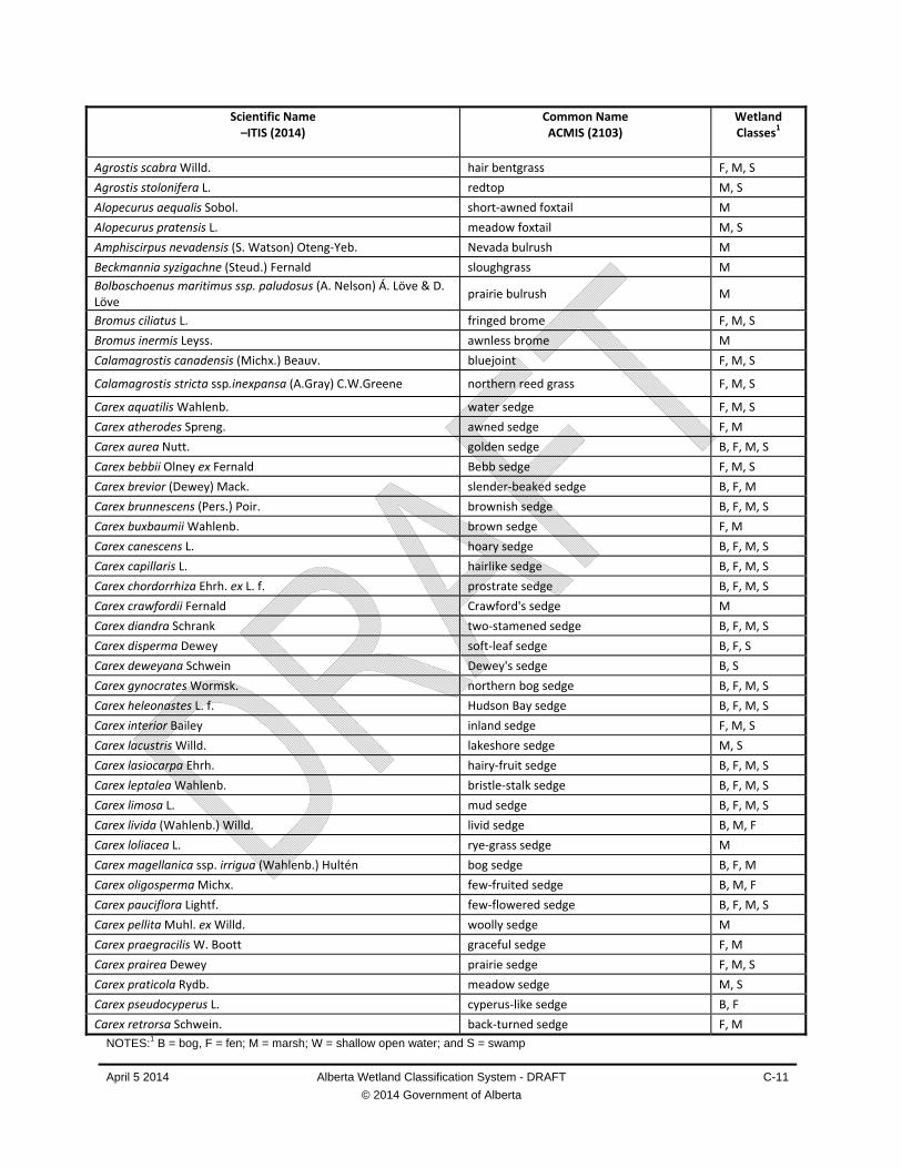
NOTES:1 B = bog, F = fen; M = marsh; W = shallow open water; and S = swamp
April 5 2014 Alberta Wetland Classification System - DRAFT
© 2014 Government of Alberta
C-11
Scientific Name –ITIS (2014)
Common Name ACMIS (2103)
Wetland Classes1
Agrostis scabra Willd. hair bentgrass F, M, S
Agrostis stolonifera L. redtop M, S
Alopecurus aequalis Sobol. short‐awned foxtail M
Alopecurus pratensis L. meadow foxtail M, S
Amphiscirpus nevadensis (S. Watson) Oteng‐Yeb. Nevada bulrush M
Beckmannia syzigachne (Steud.) Fernald sloughgrass M
Bolboschoenus maritimus ssp. paludosus (A. Nelson) Á. Löve & D. Löve
prairie bulrush M
Bromus ciliatus L. fringed brome F, M, S
Bromus inermis Leyss. awnless brome M
Calamagrostis canadensis (Michx.) Beauv. bluejoint F, M, S
Calamagrostis stricta ssp.inexpansa (A.Gray) C.W.Greene northern reed grass F, M, S
Carex aquatilis Wahlenb. water sedge F, M, S
Carex atherodes Spreng. awned sedge F, M
Carex aurea Nutt. golden sedge B, F, M, S
Carex bebbii Olney ex Fernald Bebb sedge F, M, S
Carex brevior (Dewey) Mack. slender‐beaked sedge B, F, M
Carex brunnescens (Pers.) Poir. brownish sedge B, F, M, S
Carex buxbaumii Wahlenb. brown sedge F, M
Carex canescens L. hoary sedge B, F, M, S
Carex capillaris L. hairlike sedge B, F, M, S
Carex chordorrhiza Ehrh. ex L. f. prostrate sedge B, F, M, S
Carex crawfordii Fernald Crawford's sedge M
Carex diandra Schrank two‐stamened sedge B, F, M, S
Carex disperma Dewey soft‐leaf sedge B, F, S
Carex deweyana Schwein Dewey's sedge B, S
Carex gynocrates Wormsk. northern bog sedge B, F, M, S
Carex heleonastes L. f. Hudson Bay sedge B, F, M, S
Carex interior Bailey inland sedge F, M, S
Carex lacustris Willd. lakeshore sedge M, S
Carex lasiocarpa Ehrh. hairy‐fruit sedge B, F, M, S
Carex leptalea Wahlenb. bristle‐stalk sedge B, F, M, S
Carex limosa L. mud sedge B, F, M, S
Carex livida (Wahlenb.) Willd. livid sedge B, M, F
Carex loliacea L. rye‐grass sedge M
Carex magellanica ssp. irrigua (Wahlenb.) Hultén bog sedge B, F, M
Carex oligosperma Michx. few‐fruited sedge B, M, F
Carex pauciflora Lightf. few‐flowered sedge B, F, M, S
Carex pellita Muhl. ex Willd. woolly sedge M
Carex praegracilis W. Boott graceful sedge F, M
Carex prairea Dewey prairie sedge F, M, S
Carex praticola Rydb. meadow sedge M, S
Carex pseudocyperus L. cyperus‐like sedge B, F
Carex retrorsa Schwein. back‐turned sedge F, M

NOTES:1 B = bog, F = fen; M = marsh; W = shallow open water; and S = swamp
April 5 2014 Alberta Wetland Classification System - DRAFT
© 2014 Government of Alberta
C-12
Scientific Name –ITIS (2014)
Common Name ACMIS (2103)
Wetland Classes1
Carex rostrata Stokes swollen‐beak sedge F, S
Carex sartwellii Dewey Sartwell sedge M
Carex saxatilis L. rocky‐ground sedge M
Carex stipata Muhl. ex Willd. awl‐fruited sedge M, S
Carex sychnocephala J. Carey long‐beaked sedge M
Carex tenera Dewey broad‐fruited sedge B, F, M, S
Carex tenuiflora Wahlenb. thin‐flowered sedge B, M, S
Carex torreyi Tuck Torrey's sedge M
Carex trisperma Dewey three‐seeded sedge B, F, M, S
Carex utriculata Boott small bottle sedge B, F, M
Carex vaginata Tausch sheathed sedge B, F, M, S
Carex viridula Michx. green sedge M
Carex vulpinoidea Michx. fox sedge M
Catabrosa aquatica (L.) Beauv. brook grass M
Cinna latifolia (Trev.) Griseb. drooping wood‐reed S
Deschampsia caespitosa (L.) Beauv. tufted hairgrass M
Dichanthelium acuminatum (Sw.) Gould & Clark hot‐springs millet M
Distichlis spicata ssp. stricta (Torr.) Thorne saltgrass M
Eleocharis acicularis (L.) Roemer & Schult. needle spikerush M
Eleocharis engelmannii Steud. Engelmann’s spike‐rush M
Eleocharis palustris (L.) Roemer & Schult. creeping spike‐rush M
Eleocharis quinqueflora (Hartmann) O. Schwarz. few‐flowered spike‐rush M
Eleocharis tenuis (Willd.) J.A. Schulz slender spike‐rush F
Elymus canadensis L. Canada wild rye M
Elymus repens (L.) Gould quackgrass M
Elymus trachycaulus (Link) Gound ex Shinners slender wheatgrass M
Eriophorum angustifolium Honck. tall cottongrass B, F, M, S
Eriophorum brachyantherum Trautv. & C.A. Mey close‐sheathed cotton grass M
Eriophorum chamissonis C.A. Mey. close‐sheathed cotton grass B, F, M, S
Eriophorum gracile W.D.J. Koch slender cottongrass F, M, S
Eriophorum scheuchzeri Hoppe one‐spike cottongrass B, F, M, S
Eriophorum vaginatum L. sheathed cottongrass B, F, S
Glyceria borealis (Nash) Batch. northern manna grass M
Glyceria grandis S. Wats. ex A. Gray common tall mannagrass M
Glyceria pulchella (Nash) K. Schum. graceful manna grasas M
Glyceria striata (Lam.) Hitchc. fowl manna grass M, S
Hordeum jubatum L. foxtail barley M
Juncus alpinoarticulatus Chaix alpine rush M
Juncus balticus Willd. wire rush M
Juncus brevicaudatus (Engelm) Fernald. short‐tailed rush M
Juncus bufonius L. toad rush M
Juncus longistylis Torr. long‐styled rush M
Juncus nodosus L. knotted rush M
Juncus tenuis Willd. slender rush M
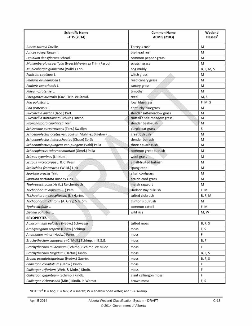
NOTES:1 B = bog, F = fen; M = marsh; W = shallow open water; and S = swamp
April 5 2014 Alberta Wetland Classification System - DRAFT
© 2014 Government of Alberta
C-13
Scientific Name –ITIS (2014)
Common Name ACMIS (2103)
Wetland Classes1
Juncus torreyi Coville Torrey’s rush M
Juncus vaseyi Engelm. big‐head rush M
Lepidium densiflorum Schrad. common pepper‐grass M
Muhlenbergia asperifolia (Nees&Meyen ex Trin.) Parodi scratch grass M
Muhlenbergia glomerata (Willd.) Trin. bog muhly B, F, M, S
Panicum capillare L. witch grass M
Phalaris arundinacea L. reed canary grass M
Phalaris canariensis L. canary grass M
Phleum pratense L. timothy M
Phragmites australis (Cav.) Trin. ex Steud. reed M, S
Poa palustris L. fowl bluegrass F, M, S
Poa pratensis L. Kentucky bluegrass M
Puccinellia distans (Jacq.) Parl. slender salt‐meadow grass M
Puccinellia nuttalliana (Schult.) Hitchc. Nuttall’s salt‐meadow grass M
Rhynchospora capillacea Torr. slender beak‐rush M
Schizachne purpurascens (Torr.) Swallen purple oat grass S
Schoenoplectus acutus var. acutus (Muhl. ex Bigelow) great bulrush M
Schoenoplectus heterochaetus (Chase) Soják slender bulrush M
Schoenoplectus pungens var. pungens (Vahl) Palla three‐square rush M
Schoeoplectus tabernaemontani (Gmel.) Palla common great bulrush M
Scirpus cyperinus (L.) Kunth wool‐grass M
Scirpus microcarpus J. & C. Presl Small‐fruited bulrush M
Scolochloa festucacea (Willd.) Link spangletop M
Spartina gracilis Trin. alkali cordgrass M
Spartina pectinata Bosc ex Link prairie cord grass M
Tephroseris palustris (L.) Reichenbach marsh ragwort M
Trichophorum alpinum (L.) Pers. Hudson Bay bulrush F, M
Trichophorum caespitosum (L.) Hartm. tufted clubrush B, F, M
Trichophorum clintonii (A. Gray) S.G. Sm. Clinton's bulrush M
Typha latifolia L. common cattail F, M
Zizania palustris L. wild rice M, W
BRYOPHYTES
Aulacomnium palustre (Hedw.) Schwaegr. tufted moss B, F, S
Amblystegium serpens (Hedw.) Schimp. moss F, S
Anomodon minor (Hedw.) Furnr. moss F
Brachythecium campestre (C. Mull.) Schimp. in B.S.G. moss B, F
Brachythecium mildeanum (Schimp.) Schimp. ex Milde moss F
Brachythecium turgidum (Hartm.) Kindb. moss B, F, S
Bryum pseudotriquetrum (Hedw.) Gaertn. moss B, F, S
Calliergon cordifolium (Hedw.) Kindb. moss F
Calliergon trifarium (Web. & Mohr.) Kindb. moss F
Calliergon giganteum (Schimp.) Kindb. giant calliergon moss F
Calliergon richardsonii (Mitt.) Kindb. in Warnst. brown moss F, S

NOTES:1 B = bog, F = fen; M = marsh; W = shallow open water; and S = swamp
April 5 2014 Alberta Wetland Classification System - DRAFT
© 2014 Government of Alberta
C-14
Scientific Name –ITIS (2014)
Common Name ACMIS (2103)
Wetland Classes1
Calliergon stramineum (Brid.) Kindb. brown moss F, S
Calliergon trifarium (Web. & Mohr.) Kindb. moss F
Calliergonella cuspidata (Hedw.) Loeske moss F
Campylium chrysophyllum (Brid.) J. Lange moss F, S
Campylium polygamum (Schimp. in B.S.G.) C. Jens. moss F
Campylium stellatum (Hedw.) C. Jens. yellow starry fen moss F
Ceratodon purpureus (Hedw.) Brid. purple horn‐toothed moss F, S
Cinclidium stygium Sw. in Schrad. moss B, F, S
Climacium dendroides (Hedw.) Web. & Mohr moss B, F, S
Dicranum fragilifolium Lindb. cushion moss B, F
Dicranum polysetum Sw. wavy dicranum moss F, S
Distichium capillaceum (Hedw.) Bruch.& Schimp. in B.S.G. moss S
Distichium inclinatum (Hedw.) Bruch.& Schimp. in B.S.G. inclined‐fruited didymodon F, S
Drepanocladus aduncus (Hedw.) Warnst. aduncus brown moss F, M, S
Eurhynchium pulchellum (Hedw.) Jen. moss B
Hamatocaulis lapponicus (Norrl.) Hedenäs hamatocaulis moss F
Drepanocladus sendtneri (Schimp.) Warnst. brown moss F
Hamatocaulis vernicosus (Mitt.) Hedenäs hamatocaulis brown moss F
Helodium blandowii (Web. & Mohr.) Warnst. Blandow's feathermoss B, F, S
Hylocomium splendens (Hedw) Schimp in BSG stair‐step moss B, F, S
Hypnum lindbergii Mitt. moss B, F
Hypnum pallescens (Hedw.) P. Beauv. moss B, F, S
Hypnum pratense (Rabenh) W. Koch ex Spruce moss F, S
Isopterygium pulchellum (Hedw.) Iwats. moss B, S
Leptobryum pyriforme (Hedw.) Wils. moss B, F, S
Leptodictyum riparium (Hedw.) Warnst. streamside leptodictyum moss F, S
Limprichtia revolvens (Sw.) Loeske limprichtia brown moss F
Meesia triquetra (Richt.) Ångstr. three‐angled thread‐moss F, S
Meesia uliginosa Hedw. moss F, S
Myurella julacea (Schwaegr.) Schimp. in B.S.G. moss F, S
Oncophorus wahlenbergii Brid. mountain curved‐back moss F, S
Orthotrichum speciosum Nees in Sturm moss F, S
Paludella squarrosa (Hedw.) Brid. moss B, F
Plagiomnium cuspidatum (Hedw.) T. Kop. moss F, S
Plagiomnium ellipticum (Brid.) T. Kop. moss B, F, S
Plagiomnium medium (Bruch & Schimp. in B.S.G.) T. Kop. moss B, F, S
Pleurozium schreberi (Brid.) Mitt. Schreber's moss B, F, S
Pohlia nutans (Hedw.) Lindb. copper wire moss B, F, S
Polytrichum commune Hedw. common hair‐cap B, F, S
Polytrichum strictum Brid. slender haircap‐moss B, F, S
Pseudobryum cinclidioides (Hub.) T. Kop. moss B, F, S
Ptilium crista‐castrensis (Hedw.) De Not. knight's plume moss F, S
Pylaisiella polyantha (Hedw.) Grout moss F, S
Rhytidiadelphus triquetrus (Hedw.) Warnst. red‐stemmed pipecleaner moss F, S

NOTES:1 B = bog, F = fen; M = marsh; W = shallow open water; and S = swamp
April 5 2014 Alberta Wetland Classification System - DRAFT
© 2014 Government of Alberta
C-15
Scientific Name –ITIS (2014)
Common Name ACMIS (2103)
Wetland Classes1
Rhizomnium gracile T. Kop. fringed bog moss F, S
Rhizomnium pseudopunctatum (B&S) T. Kop. moss B, F, S
Sanionia uncinata var. uncinata (Hedw.) Loeske hook moss F
Scorpidium scorpioides (Hedw.) Limpr. scorpidium moss F
Scorpidium turgescens (T. Jens.) Loeske moss F
Sphagnum angustifolium (C.Jens.exRuss) C.Jens.inTolf poor‐fen sphagnum; peat moss B, F, S
Sphagnum balticum (Russ.) C. Jens. balticum peat moss B, F
Sphagnum capillifolium (Ehrh.) Hedw. acute‐leaved peat moss B, F, S
Sphagnum centrale C.Jens in Arnell & C.Jens peat moss B, F
Sphagnum contortum Shultz twisted bog moss B, F
Sphagnum cuspidatum Ehrh. ex Hoffm cuspidatum peat moss B, F
Sphagnum fallax (Klinggr.) Klinggr. peat moss B, F
Sphagnum fimbriatum Wils. in Wils. & Hook. f. in Hook. shore‐growing peat moss B, F
Sphagnum fuscum (Schimp.) Klinggr. rusty peat moss B, F, S
Sphagnum girgensohnii Russ. Girgensohn's moss B, F, S
Sphagnum jensenii H. Lindb. pendant branch peat moss B, F
Sphagnum lindbergii Shimp. in Lindb. Lindberg's bog moss B, F
Sphagnum magellanicum Brid. midway peat moss B, F
Sphagnum obtusum Warnst. blunt‐leafed peat moss B, F
Sphagnum riparium Ångstr. shore‐growing peat moss F
Sphagnum russowii Warnst. wide‐tongued peat moss B
Sphagnum squarrosum Crome squarrose peat moss F, S
Sphagnum subsecundum Nees in Sturm twisted bog moss B, F
Sphagnum teres (Schimp.) Ångström thin‐leaved peat moss F
Sphagnum warnstorfii Russ. Warnstorf's sphagnum B, F, S
Splachnum ampullaceum Hedw. flagon‐fruited splachnum B
Splachnum rubrum Hedw. red collar moss B
Splachnum sphaericum Hedw. globe‐fruited splachnum B
Splachnum vasculosum Hedw. large‐fruited splachnum B
Tetraphis pellucida Hedw. moss B, F, S
Tetraplodon angustatus (Hedw.) Bruch&Schimp in BSG narrow‐leaved splachnum B, F, S
Thuidium recognitum (Hedw.) Lindb. moss B, F, S
Tomentypnum falcifolium (Ren.ex Nichols) Tuom in Ahti&Fagers. golden moss B, F
Tomenthypnum nitens (Hedw.) Loeske golden moss F
Rhytidiadelphus triquetrus (Hedw.) Warnst. red‐stemmed pipecleaner moss F, S
Warnstorfia exannulata (Schimp in B.S.G.)Loeske moss B, F, S
Warnstorfia fluitans (Hedw.) Loeske warnstorfia peat moss B, F, S
Warnstorfiia tundrae (Arnell) Loeske moos F
LIVERWORTS
Aneura pinguis (L.) Dumort liverwort F, S
Blepharostoma trichophyllum (L.) Dum. liverwort F, S
Calypogeia sphagnicola (H. Arnell & J. Perss.) Warnst & Loeske liverwort F, S
Cephalozia connivens (Dicks.) Lindb. liverwort B, F, S
Cephalozia lunulifolia (Dum.) Dum. liverwort F

NOTES:1 B = bog, F = fen; M = marsh; W = shallow open water; and S = swamp
April 5 2014 Alberta Wetland Classification System - DRAFT
© 2014 Government of Alberta
C-16
Scientific Name –ITIS (2014)
Common Name ACMIS (2103)
Wetland Classes1
Cephalozia pleniceps (Aust.) Lindb. liverwort F
Geocalyx graveolens (Schrad.) Nees liverwort F, S
Jamesoniella autumnalis (Decandolle) Steph. liverwort B, F, S
Lepidozia reptans (L.) Dum. liverwort B, F, S
Lophocolea heterophylla (Schrad.) Dum. liverwort F, S
Lophocolea minor Nees liverwort F
Lophozia grandiretis (Lindb.) Schiffn. liverwort B
Lophozia guttulata (Lindb. et H. Arnell) Evans liverwort B, F
Lophozia rutheana (Limpre.) M.A. Howe liverwort B, F
Lophozia ventricosa (Dicks.) Dum. liverwort B, F
Marchantia polymorpha L. green tongue liverwort B, F, M, S
Moerckia hibernica (Hook.) Gottsche liverwort B, F
Mylia anomala (Hook.) S. Gray liverwort B, S
Pellia endiviifolia (Dicks.) Dumort. liverwort S
Plagiochila asplenioides (Linnaeus) Dum. liverwort B, F, S
Plagiochila porelloides (Torrey ex Nees) Lindenb. liverwort F
Porella platyphylla (Linnaeus) Pfeiff liverwort S, B
Ptilidium ciliare (Linnaeus) Nees liverwort B, F, S
Ptilidium pulcherrimum (G. Web.) Hampe liverwort B, F, S
Radula complanata (Linnaeus) Dum. liverwort F, M, S
Riccia fluitans L. crystalwort M, W
Riccardia multifida (L.) Gray liverwort S
Ricciocarpos natans U purple‐fringed heartwort F, M, W
Scapania paludosa (K. Mull.) K. Mull. liverwort B
HORNWORTS
Ceratophyllum demersum L. hornwort W