alaska’s highways and byways
TRANSCRIPT

Alaska’s Highways and Byways Media Information
Driving AlaskaThe 49th State Looks Great from Behind the WheelBy Melissa DeVaughn
I remember the first time I drove across the Canadian border into Alaska, with visions oflife on the Last Frontier flooding my brain. The sun shone, and the temperature was ascorching 80 degrees, a far cry from the frozen land I expected.
A huge “Welcome to Alaska” monument stood on the border separating Canada’sYukon at Beaver Creek from Alaska on the Alaska Highway. I stopped the truck, got outand gave it a look. Technically, not a thing was different from the ground I was standingon now versus that of the land across which I just drove. But psychologically, it meantall the difference in the world. I would have years to explore the rest of Alaska on foot,dog sled and skis, but on this fine July morning, I had the open road.
Seeing what Alaska has to offer behind the wheel of an automobile or RV is an unforget-table experience. Alaska is a huge state, so driving offers a chance to see more in lesstime from the comfort of a car or RV. This doesn’t mean you’ll be cruising along at asteady 65 mph. On the contrary, Alaska’s roads require thoughtful, planned travel. Someroads are little more than gravel paths over mountain passes. Some are wide, four-laneaffairs with lots of amenities along the way. And most are something in between, welltended but modest.
“I would encourage people that besides going to the popular places like the KenaiPeninsula, that they also check out some of the more off-the-beaten-path roads,” saidKris Graef, editor of The Milepost, which for more than 50 years has offered travelersan annually updated, mile-by-mile guide to the entire Alaska road system. “There are somany other places, like the Elliott Highway, the Steese, even the Edgerton Highway.”
ALASKA HIGHWAYBut for many, there’s only the highway: The Alaska Highway, once known simply as“The Alcan.” The Alaska Highway is the main corridor between the outside world andthe 49th state, and driving it is an adventure in itself. Most of the road’s 1,520 milesactually are in Canada, beginning in Dawson Creek, B.C., and ending in Fairbanks,Alaska.

The Alaska Highway celebrated its 60-year anniversary in 2002. It has come a long wayfrom the muddy trail built to move troops and supplies during World War II. (See AlaskaHighway sidebar.)
“I remember a lot of mud, an enormous amount ofmud, especially around the little settlements wewould come to,” said Jill Shepherd, who movedfrom California to Alaska with her family in 1951,hauling a 35-foot trailer behind their 1949Studebaker pickup. “There were some places to stopand get gas, and everyone was very hospitable nomatter how small (the community) was. The truckershelped you, too. Everyone watched out for eachother.”
Today, the road is paved, but it’s not uncommon forimprovement projects to slow you down. Take the time to look for wildlife, includingbears, moose, caribou and even the occasional wolf, if you’re really lucky.
Amenities on the Alaska Highway vary greatly depending on where you are, so having aspare tire and some snacks in the car can’t hurt. But for the most part, you’ll never bemore than 50 miles from the nearest service station, and in the summer, plenty of otherexplorers travel the road.
RICHARDSON HIGHWAY
The 366-mile Richardson Highway runs from Valdez to Fairbanks and is an incrediblyscenic road trip for those willing to take it slow. The Chugach Mountains and the AlaskaRange will keep you company along the way, as will the 800-mile Trans Alaska Pipeline,which serves as a steely silver companion along the drive.
The Richardson is Alaska’s oldest road. It started out as a sled dog trail in 1898 fromValdez to Eagle. By 1902, it led to Fairbanks, and in 1910 was upgraded into a bonafide wagon trail by a man by the name of Richardson. The name has stuck ever since.
Thompson Pass, just outside of Valdez is a breathtaking spot, with open mountain vistasat an elevation of 2,678 feet. Thompson Pass is the site of some of the deepest snowfallsAlaska has ever encountered: In the winter of 1952-53, for example, the area was buriedin 81-plus feet of snow.
The Klutina and Gulkana rivers also are popular roadside attractions, and during thesummer are rich with wild Alaska salmon. Fishing guides and charter boat operators canhelp arrange a fishing expedition. Check at the Delta Junction Visitor Center for moreinformation.

South of the crossroads town of Glennallen (the Glenn Highway intersects theRichardson here, about 120 miles north of Valdez), the Wrangell Mountains tower overmiles of rolling hills. View points are scattered along the highway.
DALTON HIGHWAY
The Dalton Highway is the road to take if you simply want to drive as far north as pos-sible. From its starting point at the Elliott Highway, it continues for more than 400 milesuntil nearly reaching the shores of the Arctic Oceanin Deadhorse after crossing the Arctic Circle.Deadhorse is the village that serves the North Slopeoilfield, with several hotels, a store and gas station.The community is a superlative of sorts: it is as farnorth as you can go on Alaska’s primary road sys-tem, and it is worth exploring, especially if your goalis to dip your toe in the Arctic Ocean.
The Dalton Highway begins 85 miles north ofFairbanks and is perhaps one of the roughest roadsin Alaska. It was constructed in the mid-1970s tohaul freight to and from construction camps andworkers building the 800-mile long trans-Alaska oilpipeline that stretches from Prudhoe Bay in the northall the way to the ice-free port of Valdez in PrinceWilliam Sound. The road offers relatively little in theway of modern conveniences. The washboards aremany, the grades can be steep (as much as 10 and 12percent in some places) and the big rigs delivering toPrudhoe Bay along the “haul road,” as it’s called bythe locals, can make for uncomfortable traveling companions.
Not all car and RV rental companies allow their vehicles on the Dalton, so check aheadof time and be prepared for this road trip. Carry two spare tires, a jack, tool kit, emer-gency flares, extra gasoline, oil, wiper fluid and a first aid kit. Bring drinking water andplenty of ready-to-eat-food, and all of your camping gear. A CB radio is also not a badidea (monitor channel 19). Travel services are nonexistent. The 244-mile stretch north ofColdfoot is the longest service-free stretch of highway in North America.
So, why go to all this bother, you may ask?
Consider the scenery, which includes views of the mighty Yukon River, Atigun Pass (atthe crest of the Continental Divide), the caribou of the north slope tundra, 375-millionyear-old limestone-filled Sukakpak Mountain (elevation 4,459 feet at Mile 203.5) and
any number of sweeping mountain vistas opening into the Brooks Range, Gates of theArctic National Park or Arctic National Wildlife Refuge. Another trip highlight is cross-ing the Arctic Circle just past mile 115.
Several tour companies offer a guided Dalton Highway/Arctic Ocean experience. (See the“If You Go” section at the end of this story.)
MAIN ROADS
The Glenn, Parks and Seward highways are three of Alaska’s most-traveled roadsbecause they connect most Alaska residents. All of these roads have plenty of services,but that does not deter from the wildscenery.
The Glenn and Parks travel throughInterior Alaska, while the SewardHighway follows the coastal edges ofTurnagain Arm in SouthcentralAlaska. All of them are road tripsworth savoring.
“Another thing that I tell people is toslow down and really see Alaska,” Graef, of The Milepost, said. “I think that it wouldbe really nice for people to have shorter distances on their itineraries. Yes, you can getfrom Tok to Anchorage in one day, but if you do that you miss so much.”
On the 362-mile Parks Highway, look for stunning views of Mount McKinley, withstrategically placed pull-offs for viewing North America’s tallest peak. On sunny, cleardays the mountain seems to take up the entire sky.
The Parks travels through some quintessential Alaska communities along its way, too. Toexperience Alaska’s small-town flavor, head to Talkeetna (off the Talkeetna Spur Road atMile 99). Clapboard buildings, a railroad stop and a small local runway for the manycommuter bush planes carrying climbers to Mt.McKinley’s base camp feature prominent-ly downtown. Back on the Parks, look for the towns of Cantwell and Healy and themain park entrance to Denali National Park (at mile 237), where numerous rafting,flightseeing and tour opportunities are right off the highway.
You’ll also be traveling through Denali State Park territory, which sits adjacent to thesprawling national park. There are a number of scenic hiking and picnicking destinationsalong the way, as well as RV-equipped campgrounds, near this park. At Mile 135, thereis a particularly beautiful stopping point within the park for views of McKinley. Thepark’s maintenance status is in transition, so check with the Alaska Division of Parksand Outdoor Recreation before you go (see the “If You Go” listing at the end of this

story).
Branching off the Parks Highway near the towns of Wasilla and Palmer in theMatanuska-Susitna Valley, is the Glenn Highway. A section of the Glenn was named aNational Scenic Byway in June 2002. As you drive its 328 miles, it will be easy to under-stand why: The road offers spectacular mountain vistas dotted with Dall sheep amongthe craggy peaks. At one point along the road, you can actually pay a small fee to walkon Matanuska Glacier (Glacier Park, at Mile 102, 888-253-4980). Further down theroad is an awesome view of Gunsight Mountain, a must-have photo for your album.And if you have time, turn off at Mile 160 for a side trip to Lake Louise StateRecreation Area.
The spectacular Wrangell Mountains in the nation’s largest national park, Wrangell-St.Elias, begin to come into view on the Glenn, but a short drive south on theRichardson reveals their stunning repose.
The Seward Highway, which travels 127 miles from Anchorage to Seward, has been offi-cially cited as an All-American Road, a recognition by the National Scenic Byways pro-gram that goes to a few and select group of national highways (for more on Alaska’sScenic Byways, see our accompanying story on the Scenic Byways program). The SewardHighway has it all — spectacular views of Turnagain Arm, scenic rest stops for belugawhale and Dall sheep watching, parking areas for access to some premier hiking trails inChugach National Forest and countless camping, lodging and dining opportunities.
For those who have very little time to spend in Alaska, the Seward Highway is a viabledestination unto itself. This is the best road from which to see a huge cross-section ofAlaska’s topography — from fireweed-covered hillsides to frozen-in-time glaciers, fromserene lakes to fast-flowing rivers and streams.
OTHER OPTIONSFinally, if you’re interested in a “short” drive, consider a one- or two-day jaunt alongsome of Alaska’s less-traveled roads The ELLIOTT HIGHWAY covers 152 miles fromjust north of Fairbanks to the town of Manley and Manley Hot Springs in the state’sInterior. Look for such attractions as Minto Lakes and the hot springs in Manley, anattraction among those seeking pure solitude. There is also the Arctic Circle TradingPost, at Mile 49 (907-474-4565), which is worth a look. The shop offers an officialArctic Circle registry, in which you can list your name and receive a souvenir certificateof arrival to the far north.
There are several campgrounds and a few places to re-supply along the way. In general,though, expect the mostly gravel road to be lightly traveled. When you get to ManleyHot Springs, check in at the Manley Roadhouse (Mile 152) for accommodations anddetails about soaking in the hot springs. The etiquette goes something like this: The hotsprings are on private property, but visitors are welcome to use them by asking at the

roadhouse for an assigned time during which they can soak. Remember, this is a smalltown. Formalities, such as appointments, are foreign but good manners, such as askingpolitely, are expected.
Another northern road worthy of exploration is the STEESE HIGHWAY, a 162-mile-long road heading from Fairbanks to Circle. Most of the road is gravel, and conditionscan vary with the weather. But the road is worthy of exploration because of its unob-structed views and access to summer and winter play areas. The Chena River andChatanika River recreation areas offer summertime amusement for visitors and localsalike, and in the winter, there is access to theWhite Mountains National Recreation Area,which offers miles of groomed snow surface forskiers, snowmachiners and dog mushers. A relax-ing end to this drive comes a few miles from thesmall mining community of Central. Circle HotSprings features a Victorian-era hotel with restau-rant and access to a steamy hot springs pool.
Further south is the equally stunning but some-times less-maintained DENALI HIGHWAY, whichconnects the communities of Cantwell, on the Parks Highway, and Paxson, on theRichardson Highway. All but 20 miles of the 134-mile road is gravel, and dependingupon the weather, the road can become washed out and slick. There are a few designatedcamping areas and some comfortable lodges to stay at, but in general, be prepared for arustic trip with stunning scenery. Near the Richardson Highway end of the DenaliHighway, Tangle Lakes is a particularly popular area with grayling fishing, canoeing andoutstanding bird-watching.
Before you go, be sure to check the state’s Department of Transportation roads hotlinefor the Denali Highway’s current maintenance status.
ROAD RULES: Be road-friendlyTo make the driving experience more enjoyable for you and your fellow travelers, hereare a few rules of the road to keep in mind while exploring Alaska:1. Drive at the posted speed limit or within safe road conditions, and check your rear-view mirror often. On many roads in Alaska, it is required that you pull off to let five ormore vehicles behind you pass. If you want to be really nice, pull off when you see threeor more. 2. Always drive with your headlights on. Even in the summer, when the sun stays abovethe horizon nearly all night, those headlights can be helpful. Oncoming traffic is morelikely to see you, especially in rainy weather. 3. Park only at waysides or other designated parking areas. Don’t assume a pull-off is a

good place to camp; you may just be blocking access to someone’s remote cabin. 4. Keep Alaska beautiful. Save RV waste for dumping stations and trash for your stopsin town. Not only is litter unsightly, but animals who munch on it can become sick ordie.
IF YOU GO:
Alaska Travel Industry Association (800) 862-5275www.travelalaska.com
Tourism North www.northtoalaska.com
The Milepost: This phone book-sized guide offers mile-by-mile descriptions of the road-ways in Alaska and parts of Canada. www.themilepost.com
The Alaska Department of Transportation (800) 478-7675 The department has a statewide road-conditions hotline accessible by phone or on theweb www.dot.state.ak.us
State of Alaska Scenic Byways Informationwww.dot.state.ak.us/scenic/
Museum of Alaska Transportation & Industry (907) 376-1211www.alaska.net/~rmorris/mati1.htm
DALTON HIGHWAY
Northern Alaska Tour Co. (907-474-8600) offers tours of the Dalton Highway andArctic Ocean. www.northernalaska.com
Trans-Arctic Circle Treks Ltd. is a tour operator that offers a “High-Arctic Three DayTour.” Optional flightseeing trips can be arranged. Contact them at 4825 GlasgowDrive, Fairbanks, AK 99709, (800) 336-8735 www.arctictreks.com

RICHARDSON HIGHWAY
Delta Junction Visitors Center is located at the junction of the Alaska Highway and theRichardson Highway. (907) 895-9941 or (877) 895-5068www.alaska-highway.org/delta
Valdez Convention and Visitors Bureau: (800) 770-5954 www.valdezalaska.org
ELLIOTT, STEESE AND DENALI HIGHWAYS
Fairbanks Convention and Visitors Bureau: The Fairbanks CVB can also provide infor-mation on the Richardson and Parks highways. (907) 456-5774www.explorefairbanks.com
Manley Roadhouse (907) 672-3161
GLENN AND SEWARD HIGHWAYS
Anchorage Convention and Visitors Bureau: (800) 478-1255www.anchorage.net
Seward Chamber of Commerce: (907) 224-8051www.sewardak.orgPARKS HIGHWAY
Denali State Park Ranger (907)745-3975www.dnr.state.ak.us/parks/units/denali1.htm
Mat-Su Convention & Visitors Bureau: (907) 746-5000www.alaskavisit.com
Photo credits in order of appearance: Alaska Division of Community and Business Development/markWayne, ATIA, ATIA.
Roadhouses Still a Way of Life Along Alaska’s Road System
In Alaska’s early days, pioneers began building the first roads between communities, and,along with them, the roadhouse. The arrival of these bastions of comfort were muchwelcome to road-weary travelers. The roadhouses offered a warm place to sleep, hotfood and some much-sought-after conversation.
At the turn of the 20th century, these roadhouses were found across Alaska, often every20 or so miles apart from one another and a manageable distance for those traveling bystagecoach, horse or dog sled. They were simple buildings, low-roofed and built of thicklocally cut timbers. Most of them were log, although clapboard buildings showed upnow and then, as well.
In many areas, they needed no distinction and often were simply called “TheRoadhouse.” Today, many still offer room and board, while others stand as a historicreminder of the early days of transportation.
Knik Hall: This roadhouse is thought to have been constructed sometime between 1900and 1914, and originally was used as a roadhouse, pool hall and store. The two-story,wood-framed building still stands today and is home to the Knik Museum and Sled DogMusher’s Hall of Fame. To find it, turn south off the Parks Highway in Wasilla ontoKnik Road and drive about 14 miles.
Sourdough Roadhouse: This 1906-era building is one of Alaska’s better-known road-houses, and is billed as the longest-running original roadhouse in Alaska. Built along thethen-Valdez-to-Fairbanks Trail, it today can be found at Mile 147.5 of the RichardsonHighway. The roadhouse still serves Richardson Highway travelers and is a recognizedNational Historic Landmark.
Rika’s Roadhouse: This delightful roadhouse still operates today as a historic site at theBig Delta State Historical Park at Mile 275 of the Richardson Highway. The roadhousewas yet another Alaska Railroad project, built in 1909 and 1910. It was used a stoppingpoint for those on the Valdez-to-Fairbanks Trail. After the Richardson Highway wasbuilt and upgraded, the roadhouse became less prominent and its owner, Swedish immi-grant Rika Wallen, closed the doors. The State of Alaska upgraded the building in 1986and it became the popular roadside diversion it is today.
Gakona Lodge and Trading Post: Built in 1905, the original roadhouse sits next to anewer two-story log counterpart built in 1929. Today’s lodge is on the National Registerof Historic Places and features an excellent dinner out of the Carriage House diningroom. Look for both at Mile 2 of the Tok Cutoff.

Copper Center Lodge: The lodge was built in 1897, and it still serves travelers todaywith basic rooms and a restaurant featuring sourdough pancakes. The roadhouse can befound past Mile 100 on the Old Richardson Highway.
Manley Roadhouse: This roadhouse, filled with antiques, is an antique itself. It was builtin 1906 to serve dog mushers, gold prospectors and the occasional adventurer of theearly 1900s. The roadhouse still operates today, with accommodations with shared andprivate baths. Look for it near Mile 150 of the Elliott Highway in Interior Alaska.

It’s All Scenic:National Byways Program Recognizes Best of Alaska’s Roads
There’s one thing Alaska has no shortage of, and that’s incredible scenery along its manyhighways. The problem often is not whether to take a road trip but which one to take.
Alaska has come to the attention of the National Scenic Byway program, established byCongress in 1991. The program preserves and protects the nation's most scenic roadsand, at the same time, promotes tourism and economic development along them. Roadsare judged on six intrinsic values — archaeology, culture, history, nature, recreation andscenic qualities. Alaska has had three such road systems nationally recognized, and 11that have been recognized by the state.
The Seward Highway is Alaska’s crown jewel. It was given the national program’s high-est honor as an All-American Road in 2000, and was named a National Forest ScenicByway in 1998. To receive an All-American Road designation, a road must have one-of-a-kind features that do not exist elsewhere and it must also had to be considered a "des-tination unto itself," according to the National Byways program.
“The basic premise of the program is that there are 4 million miles of highway inAmerica, and there are just some that are so unique that they should be recognized,”said Murph O’Brien, the regional byway facilitator in Anchorage.
The 127-mile Seward Highway is indeed a trip worth taking. From Anchorage, it followsthe coastline of Turnagain Arm, climbs Turnagain Pass onto the Kenai Peninsula andmeanders through the mountains of Chugach National Forest as it heads to the waters ofResurrection Bay and Seward. The drive can take three to five hours if you take yourtime and stop often for photos.
A portion of the Glenn Highway between Anchorage and Glennallen was recognized asa National Scenic Byway in June 2002. Those who travel the Glenn Highway will under-stand why it was recognized, with spectacular mountain scenery (King and Pinnaclemountains, along the Matanuska River, are particularly photogenic) and access to severalpopular recreation areas.
For the first time in the history of the National Scenic Byways program, a marine-basedsystem was recognized. The Alaska Marine Highway, which celebrates its 40th anniver-sary this year, also received a National Scenic Byway designation in June 2002.
The Alaska Marine Highway covers nearly 9,000 miles of coastal ocean routes connect-ing 31 port communities throughout Alaska as well as a port in British Columbia andone in Washington. It’s a great way to see the coastal regions of Alaska yet still haveaccess to a vehicle for inland travel.

On the ferry, you’ll see some of the less-visited communities of Alaska, have a chance tophotograph whales and other sea creatures, and, in general soak in the essence of coastallife. Vehicles and RVs are allowed, and there are cabins with bunks for overnight sail-ings.
There also is a statewide Scenic Byways program, O’Brien said, and so far, 11 roadways— including the Alaska Marine Highway and the Alaska Railroad — have been recog-nized since 1993. The other highways are the Glenn, Seward, Dalton, Haines, Steese,Taylor, Parks between Denali State Park and Healy, Richardson between Valdez andGlennallen and Sterling from the Seward Highway to the southern exit at Skilak Lakeand from Anchor Point to the Homer Spit.
IF YOU GO:
Alaska Scenic Byways Program www.dot.state.ak.us/scenic/
Alaska Public Lands Information Center: (907) 271-2737www.nps.gov/aplic/center/
Alaska Department of Transportation and Public Facilities: Road Condition Hotline(800) 478-7675www.dot.state.ak.us
Chugach National Forest: (907) 743-9500www.fs.fed.us/r10/chugach/
Matanuska-Susitna Convention & Visitor Bureau: (907) 746-5000www.alaskavisit.com
Alaska Marine Highway System: (8000 642-0066www.ferryalaska.com

The Anton Anderson Memorial Tunnel – Gateway to Whittier
This Tunnel gives visitors the opportunity to drive through the Chugach Mountains toreach the sea at the northwest edge of the Prince William Sound community of Whittier.The $90 million Whittier toll road isn’t a long drive – only about 12.5 mi (20 km) – butit’s interesting. Leaving the Portage Road near the Begich Boggs Visitor Center on theshores of Portage Lake, the new highway passes 430 ft (131 m) through a tunnel in thebase of Begich Peak into Bear Valley. A desolate bowl full of willows, rocks and tundraat the base of Boggs Peak, the valley is aptly named for the wildlife that roam the area. Not far beyond where the salmon spawn, the Whittier road stretches from one lane totwo as drivers begin a 2.5 mi (4km) journey through the heart of a mountain sharedwith the Alaska Railroad. This is the last and longest of the two tunnels. Emerging at the Prince William Sound end of the tunnel, drivers find themselves inWittier at the head of Portage Canal. Built quickly as a hidden, ice-free port for theU.S. military during World War II, the community hasn’t changed much since.Here, visitors will have the option of incredible adventures by high-speed catamaransinto Prince William Sound for a day of visiting as many as 26 glaciers. Kayakers alsouse this port town for staging expeditions or daytrips into the sound. And, of course,the Alaska Marine Highway, the M/V Bartlett, begins its Prince William Sound traversein Whittier.

Sights of the sea:Alaska Marine Highway Celebrates 40 Years of Serving Residents and Visitors By Melissa DeVaughn
For longer than recorded time, watery pathways have been Alaska’s thoroughfares. Aleuttraders in tiny sea-hugging bidarkas sailed here. Brightly painted Tlingit war canoessailed to potlatches. Explorers from Spain, England, Russia and France – some purposelyseeking a northwest passage, others hopelessly lost – mapped these waters. Fur tradersand lumbermen raised sail here and gold seekers packed into leaky steamers on their wayto the Klondike. Sailors sweated and shivered in wartime submarines on patrol. In the1970s, oilfield workers greased their toolboxes against the salt air and sailednorth.Today, every type of vessel from fiberglass kayaks to oil tankers to luxury cruiseships ply these waterways, and among them, the great ferries of the Alaska MarineHighway move patiently and predictably, taking ordinary people on an extraordinaryvoyage.
The vessels of the Alaska Marine Highway trace thousands of miles of the world’s mostscenic coastline. From the verdant rain forests of Northern British Columbia and theInside Passage of Southeast Alaska to the smoldering volcanoes of the Aleutian Chain tothe glaciers and fjords of Prince William Sound, the ships glide over crystal seas andplow through ocean swells.
The Alaska Marine Highway has been offering its passengers a chance to escape for 40years, starting with just one vessel, the M/V Malaspina, which arrived in Ketchikan onJan. 23, 1963. Today, the ferry system has nine vessels and anticipates at least two moreby the end of 2004.
“It is not happenstance that the term ‘highway’ is in our name,” said Alaska MarineHighway General Manager George Capacci. “The Marine Highway is the way peopleand vehicles move about in the coastal zone of Alaska.”
Anchorage resident Tim Deal and his brother-in-law have taken the ferry M/VTustumena from Homer to Port Lions on Kodiak Island several times to go hunting. Andalthough, as a pilot for Alaska Airlines, he likes to fly, he recommends the ferry to every-one.
“The ferry left at 8 p.m. so it was an all-night crossing,” Deal said. “But we used ourground pads and a sleeping bag and slept up on deck.” At times, the crossing around theBarren Islands got rough, but as they approached Homer on the return trip, the sight ofKachemak Bay was unforgettable.
“People were starting to rouse and we got up and had a nice breakfast in the restau-rant,” he said. “It was a great trip, a great way to travel.”
In fact, Deal, his wife and three boys are hoping to plan a ferry trip all the way to DutchHarbor, in the Aleutians, for one of their upcoming vacations. And the oldest Deal boy,Conor, has a school fieldtrip planned from Whittier to Cordova.
Sharon Gaiptman, marketing manager for the Alaska Marine Highway, recommendsthat sightseers not only take in the glacier-and-wildlife-rich Inside Passage but also sug-gests a ferry ride like Deal’s, from Homer or Seward to Kodiak. Such trips give visitors asense for the rhythm of Alaska’s rural communities.
“Anchorage in the summertime is the No. 1 visitor destination for Alaska MarineHighway passengers,” Gaiptman said. “They also want to see Juneau, the (Matanuska-Susitna Valley), Fairbanks and Kenai. Only one of those places is in the Inside Passage,and that’s the thing about the Alaska Marine Highway. You can get to all those placesand do it on your own schedule.”
Part of the Marine Highway’s 40th anniversary “Sailabration” is the system’s recent des-ignation as a National Scenic Byway, a federally funded U.S. Department ofTransportation program that recognizes unique and scenic roadways. This is the firsttime a marine-based system has received the honor, Gaiptman said, and there is still a lotof work to be done on a local level to promote the honor.
“Being the first marine-based scenic byway award makes this doubly exciting,”Gaiptman said. “We’re planning to have dedications at every port location, and there are33 ports and about 3,000 miles — 8,800 miles when you count all the routes together.”
Capacci said the yearlong Sailabration also will include: a ceremony to name the ferrycurrently being built to serve residents of Metlakatla; special travel offers for those on abudget; and, the unveiling of the Marine Highway’s official 40th anniversary poster.
Although there will be special 40th birthday celebrations all year, it will still be businessas usual for the ferry system, especially for those who rely on the ferry for everydaytransportation. “Many Alaska families, like mine, rely on the ferry system, and in manycases, it’s the only way to get a high school sports team to a regional tournament. It's thesame for church groups, for individuals who need medical care, for shopping opportuni-ties or for those who want to attend regional cultural events.”

“There is no perfect way to see Alaska,” Gaiptman said. “The reality is that I think thatthere are many special ways to get around Alaska, but the Marine Highway is amongthe most unique because it enables you to see Alaska your way.
“You can get on and off when you want,” Gaiptman continued. “If you want to taketime and see communities in the Inside Passage, you can do it. If you want to get off andtravel inland, you can do it. You just kind of sit there and go, ‘Here’s the Alaska of mydreams. Here’s the Alaska not many people see.’ “
IF YOU GO FERRYING
Walk-on reservations are almost never needed. But if you want a private cabin or tobook vehicle, you should call ahead of time. Cabins are comfortable but small, and keepin mind that the beds are in a bunk arrangement. If you need two beds for sleeping butneither person in your party can climb to a top bunk, get a four-berth cabin with twobunks. Kayaks, bicycles and other outdoor gear are allowed. Call ahead for details. Petsmay travel with you, but must have current health certificates (within 30 days) in orderto travel through Canada or into Alaska from another state. The cost for pets is $10 to$25, depending upon your port of departure. Pets must stay in pet carriers or in yourvehicle.
Alaska Marine Highway: (800) 642-0066www.ferryalaska.com

Alaska Marine Highway Running Times
Taking the ferry reminds you that Alaska is a big place—a very big place. The following
timetable, provided by the Alaska Marine Highway, will give you an idea of how long it will
take to reach your port of call.
All times are approximate. Weather, tidal conditions and the amount of traffic on the water all
will affect how long it takes to reach a particular destination.
Our advice? Don’t worry about it. Slow down, enjoy the views and use the ferry time to relax.
Now that sounds like a great vacation!
To reach the Alaska Marine Highway, call 1-800-642-0066 or visit www.dot.state.ak.us/amhs/.
Southeast Alaska
Inside Passage
Bellingham, Wash. to Ketchikan 37 hours
Prince Rupert to Ketchikan 6 hours
Ketchikan to Wrangell 6 hours
Wrangell to Petersburg 3 hours
Petersburg to Juneau 8 hours
Petersburg to Sitka 10 hours
Sitka to Juneau/Auke Bay 8 hours, 45 minutes
Juneau/Auke Bay to Haines 4 hours, 30 minutes
Haines to Skagway 1 hour
Southeast Alaska
Smaller, feeder routes
Ketchikan to Hollis 2 hours, 45 minutes
Ketchikan to Metlakatla 1 hour, 15 minutes
Metlakatla to Hollis 3 hours, 30 minutes
Hollis to Wrangell 6 hours, 30 minutes
Hollis to Petersburg 8 hours, 30 minutes
Petersburg to Kake 4 hours
Kake to Sitka 8 hours
Kake to Angoon 4 hours

Sitka to Angoon 5 hours, 30 minutes
Angoon to Hoonah 4 hours
Angoon to Tenakee 2 hours, 30 minutes
Tenakee to Hoonah 3 hours, 15 minutes
Hoonah to Juneau 3 hours, 15 minutes
Hoonah to Pelican 4 hours, 15 minutes
Juneau to Pelican 6 hours, 30 minutes
Southcentral Alaska
Valdez to Cordova 5 hours, 30 minutes
Cordova to Whittier 7 hours
Whittier to Valdez 6 hours, 45 minutes
Cordova to Seward 11 hours
Valdez to Seward 11 hours
Seward to Kodiak 13 hours, 15 minutes
Kodiak to Port Lions 2 hours, 30 minutes
Port Lions to Homer 10 hours
Homer to Seldovia 1 hour, 30 minutes
Homer to Kodiak 9 hours, 30 minutes
Southwest Alaska
Kodiak to Chignik 18 hours, 30 minutes
Chignik to Sand Point 9 hours, 15 minutes
Sand Point to King Cove 6 hours, 30 minutes
King Cove to Cold Bay 2 hours
Cold Bay to False Pass 4 hours, 15 minutes
False Pass to Akutan 10 hours, 30 minutes
Akutan to Unalaska 3 hours, 30 minutes
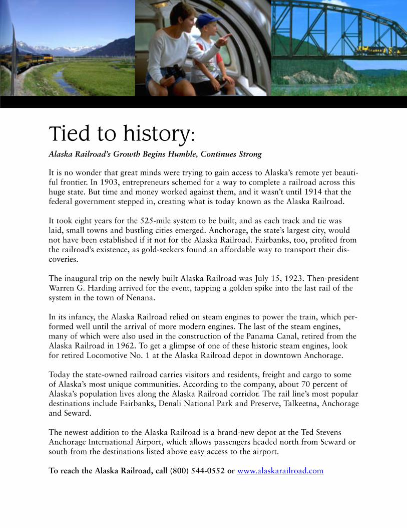
Tied to history:Alaska Railroad’s Growth Begins Humble, Continues Strong
It is no wonder that great minds were trying to gain access to Alaska’s remote yet beauti-ful frontier. In 1903, entrepreneurs schemed for a way to complete a railroad across thishuge state. But time and money worked against them, and it wasn’t until 1914 that thefederal government stepped in, creating what is today known as the Alaska Railroad.
It took eight years for the 525-mile system to be built, and as each track and tie waslaid, small towns and bustling cities emerged. Anchorage, the state’s largest city, wouldnot have been established if it not for the Alaska Railroad. Fairbanks, too, profited fromthe railroad’s existence, as gold-seekers found an affordable way to transport their dis-coveries.
The inaugural trip on the newly built Alaska Railroad was July 15, 1923. Then-presidentWarren G. Harding arrived for the event, tapping a golden spike into the last rail of thesystem in the town of Nenana.
In its infancy, the Alaska Railroad relied on steam engines to power the train, which per-formed well until the arrival of more modern engines. The last of the steam engines,many of which were also used in the construction of the Panama Canal, retired from theAlaska Railroad in 1962. To get a glimpse of one of these historic steam engines, lookfor retired Locomotive No. 1 at the Alaska Railroad depot in downtown Anchorage.
Today the state-owned railroad carries visitors and residents, freight and cargo to someof Alaska’s most unique communities. According to the company, about 70 percent ofAlaska’s population lives along the Alaska Railroad corridor. The rail line’s most populardestinations include Fairbanks, Denali National Park and Preserve, Talkeetna, Anchorageand Seward.
The newest addition to the Alaska Railroad is a brand-new depot at the Ted StevensAnchorage International Airport, which allows passengers headed north from Seward orsouth from the destinations listed above easy access to the airport.
To reach the Alaska Railroad, call (800) 544-0552 or www.alaskarailroad.com
Hitch a ride on the rails: Alaska Railroad Offers On-board Comfort, Off-board Adventure
Taking a day trip on the Alaska Railroad is an unforgettable experience for people of all ages.From its unique flag-stop service to exhilarating rafting-and-riding combination packages, theAlaska Railroad has something to offer travelers of all ages and inclinations.
From the comfort of roomy coaches with oversized seats and giant windows, you can see Alaskaat its most wild. The railroad climbs through mountain passes and across open valleys, skirtwithin a few hundred yards of glaciers and parallel coastal inlets.
You can take in this spectacular scenery from the comfort of the rail cars, while eating in the din-ing car or while standing outside on the small platforms between cars. The Alaska Railroad evenfeatures special domed cars that offer a bird’s-eye view of the surrounding landscape in a double-decker glassed-in enclosure.
But with its unique flag-stop service, the Alaska Railroad takes sight seeing by rail a step further.This is just one of the services that make this state-owned railroad so special.
“We have what is called the Hurricane Turn, a flag-stop service, and it runs … from Talkeetnaup to Hurricane (Gulch),” said Alaska Railroad sales executive Jeff Johnson. “For a long time ithas been popular with the locals to reach their cabins, although it is becoming more popularwith campers and fisherman.”
The flag-stop service harks back to an earlier era and conjures images of a Norman Rockwell-esque engineer waving to his passengers as if they’re old friends. In times past, getting around viatrain was just that easy: get off the train where you choose, and flag it down when you want toget back on. In Alaska, where so much of life has remained consciously simple, that freedom stillexists today.
Locals may see the flag-stop service as a necessity, but visitors to Alaska will be intrigued by therecreational opportunities it affords. Board the train in Talkeetna, about two hours north ofAnchorage, and bring along a fishing pole, camera or backpack. On clear days, the hulk ofNorth America’s highest peak, 20,320-foot Mount McKinley, dominates the landscape. If you getoff close to Hurricane Gulch, hang on. The Hurricane Gulch trestle is nearly 300 feet above thecreek below and offers wide-open views in every direction.
The flag-stop service is a great option if you’re an independent traveler comfortable with yourwilderness survival skills. Carry a map and compass, be prepared for cold weather, even in thesummer, and be respectful of private-property owners. It’s a great ride even if you don’t get offthe train, offering a glimpse of some of Alaska’s most remote back country.
Sound just a bit too ambitious? If you like the idea of an off-train excursion, but would preferthe company of others, the Alaska Railroad has yet another option, this one brand-new for2003, called the Glacier Discovery Train.
The train takes off from Anchorage and arrives near Spencer Glacier, at which point passengers

may disembark for a raft trip down the Placer River or stay aboard for a few more miles to thescenic, much-photographed area of Grandview. Those who opt for the two-hour float trip willmeander through the wilderness until they reach the Seward Highway, where the Placer Rivercrosses. Visitors then board a motorcoach for a leisurely drive back to Anchorage, just in timefor dinner.
“There really seems to be a need for more day tours out of Anchorage and we thought it was aperfect fit,” Alaska Railroad Marketing Manager Susie Kiger said. “(Passengers) will enjoy a nicelunch out on the boat of fresh fruit, caribou, and salmon. They’ll be pampered a bit, but it won’tbe difficult, just beautiful. In fact, a 5-year-old could do it.”
Don’t think of the raft trip as a white-knuckle adventure, said Johnson. “Actually, it’s a very mel-low float, so it’s good for everybody — it’s a very scenic float just a few hours out of Anchorage,and that’s why it’s special.”
IF YOU GO:
The Alaska Railroad offers many other tour packages on its more than 500 miles of rail. AnAnchorage-to-Seward day trip called the Coastal Classic is one of the most popular trips. Or trythe 356-mile trip between Anchorage and Fairbanks.
The Alaska Railroad: (800) 544-0552www.alaskarailroad.com
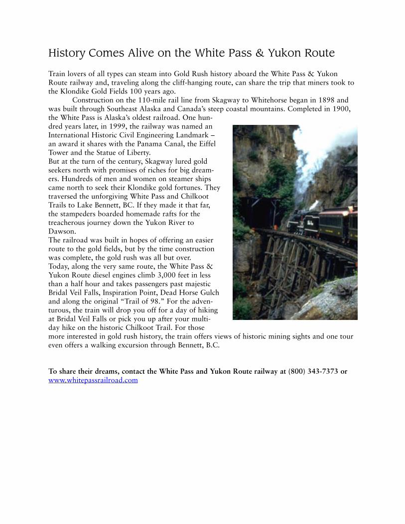
History Comes Alive on the White Pass & Yukon Route
Train lovers of all types can steam into Gold Rush history aboard the White Pass & YukonRoute railway and, traveling along the cliff-hanging route, can share the trip that miners took tothe Klondike Gold Fields 100 years ago.
Construction on the 110-mile rail line from Skagway to Whitehorse began in 1898 andwas built through Southeast Alaska and Canada’s steep coastal mountains. Completed in 1900,the White Pass is Alaska’s oldest railroad. One hun-dred years later, in 1999, the railway was named anInternational Historic Civil Engineering Landmark –an award it shares with the Panama Canal, the EiffelTower and the Statue of Liberty. But at the turn of the century, Skagway lured goldseekers north with promises of riches for big dream-ers. Hundreds of men and women on steamer shipscame north to seek their Klondike gold fortunes. Theytraversed the unforgiving White Pass and ChilkootTrails to Lake Bennett, BC. If they made it that far,the stampeders boarded homemade rafts for thetreacherous journey down the Yukon River toDawson. The railroad was built in hopes of offering an easierroute to the gold fields, but by the time constructionwas complete, the gold rush was all but over. Today, along the very same route, the White Pass &Yukon Route diesel engines climb 3,000 feet in lessthan a half hour and takes passengers past majesticBridal Veil Falls, Inspiration Point, Dead Horse Gulchand along the original “Trail of 98.” For the adven-turous, the train will drop you off for a day of hikingat Bridal Veil Falls or pick you up after your multi-day hike on the historic Chilkoot Trail. For thosemore interested in gold rush history, the train offers views of historic mining sights and one toureven offers a walking excursion through Bennett, B.C.
To share their dreams, contact the White Pass and Yukon Route railway at (800) 343-7373 orwww.whitepassrailroad.com

A writer’s memories of theAlaska HighwayBy Stanton H. Patty
ALASKA-CANADA BORDER -- “Where are you headed today, pardner?” Theimmigration officer at the Alaska-Yukon border on the Alaska Highway had the voice ofa Texas cowpoke.
“Going home,” I said.“Where’s that?”“Alaska—Fairbanks. “I don’t live there now, but that’s where I’m from.”“How long ago was that?”“Way before you were born.”“That long, huh? “Well, you have a good one,” he said, waving me north.
“Welcome home.”I’d been on the Alaska Highway since 5 a.m., camera cocked and ready. First
light was sweeping like a golden wave across spruce and birch forests that roll over thehorizon, beyond imagination. I’d driven this highway enough to know that this was thehour when magic creeps along the ALCAN as it was once known.
A young black bear, not bothered at all by the sight of a tourist’s car, sat smack inthe middle of the road and looked my way. I stopped and reach for the camera, but itwas too late. The bear bounded off into the woods.
Around the very next corner a cow moose was drinking from a pond where shad-ows had turned the water the color of dark sapphires. Another perfect photo op. As Istopped to grab another shot, I found that I was talking to myself and rememberinggood times along the Alaska Highway.
Northway Junction
At Northway Junction, just ahead at Milepost 1264 of the Alaska Highway, Iremembered well the last time I turned for the Northway village -- (pop. 364) – a fewyears ago to talk with Chief Walter Northway. I wanted to know more about the WorldWar II years, when American-built warplanes were being ferried to Russia via Northwayand other North country airfields.

It was early in 1941. Nazi troops had driven deep into the Soviet Union. Russiawas fighting for its life. The United States was not yet in the war. But could the U.S. pro-vide urgently needed fighter planes and bombers to help turn the tide against Germanyon the Eastern Front?
Yes. The United States government offered to fly lend-lease aircraft all the way toSiberia. But the wary Soviets didn’t want us learning about the Siberian airfields.
So, it was agreed that American pilots would deliver the planes to Fairbanks,where they would be turned over to Soviet aircrews. Russian pilots then would whiskthem from Fairbanks to Nome, then across Bering Strait to Siberia and on to theEuropean combat zones.
Soon a chain of landing strips was sown across more than 2,000 miles of Canadaand Alaska for ferrying the planes to Fairbanks. The network of airfields was designatedthe Northwest Staging Route. But most of those who were there remember it as theAlaska-Siberia Route. ALSIB, for short.
ALSIB’S operations stretched from Great Falls, Mont., through Calgary andEdmonton and other sites in Alberta, then Fort St. John and Fort Nelson in BritishColumbia, to Watson Lake and Whitehorse in Canada’s Yukon Territory, and finallythrough Northway, Tanacross and Big Delta in Alaska to Ladd Field at Fairbanks.Many of the airports would later become bases for building the wartime AlaskaHighway, a raw truck trail punched through the wilderness in just eight months and 11days. The Army Corps of Engineers called the project “one of the greatest undertakingssince the building of the Panama Canal.”
But in order for the warplanes to move west, the airstrips had to be built. WalterNorthway, traditional chief of his Athabascan Indian Village, was hired as a $1 an hourlaborer to clear brush for the airstrip at Northway.
The Chief’s Athabascan name, Haa Chi’jinii’aa, means “Looking Back”—back toa time when time, as we know it, did not exist.
Northway was the name given to Walter’s father by Capt. James A. Northway, agold–rush trader in Alaska’s heartland. It seems the captain couldn’t pronounce thefather’s Indian name, T’aaiy Ta—“Strong Man.”
By the time World War II ended, more than 7,800 warplanes had been deliveredto the Soviet Union over the ALSIB Route.
Ladd Field at Fairbanks, where Russian pilots bunked and bought chocolate barsand lingerie for their back-home wives and girlfriends, has changed, and it’s now calledFort Wainwright.
Now the Alaska Highway is paved. Travelers in all sorts of rigs, from familysedans to RV’s, travel my favorite highway in comfort to explore the north’s heartland.Legends such as Walter Northway are gone. I miss them. But there’s another story justup the road to tell.
Dawson Creek, BC and Points North
I drive on from Northway Junction, watching a jet trail streak across the blueber-ry sky. A car packed with a boisterous family zooms past, and I’m immediately remindedof when, as a boy, my family drove the Alaska Highway. Three boisterous brothers were

scrapping in the back seat of the 1935 Plymouth.“Stop that!” my father shouted, blowing a nauseous blue cloud of cigar smoke
over his right shoulder.“I’m getting carsick,” I complained.“If you don’t behave, we’ll stop and cut a switch off one of those willows.” Dad
said. “I mean it.”He meant it. We three had qualified for many switchings on family outings. But
just then, the car began swaying. A stray rock had punctured the gasoline tank. We werein trouble. My mother reached into her purse and produced two packages of gum.“Quickly, boys” she said—chew!”
We chewed big wads of rubbery gum until our cheeks puffed.“I’m running out of spit,” Ernie complained.“Never mind, chew!” Mom said.A few minutes later she collected the masticated goo, patted it into a sort of flap-
jack and handed it to my dad.“Use this to patch the tank,” she instructed, and he did as he was told.How many times have I traveled the Alaska Highway? Maybe a dozen in all sea-
sons. In family cars, RVs and aboard the highballing trucks while gathering stories forThe Seattle Times and other newspapers.
Once on a trip with my granddaughter Christine, we panned for gold near HainesJunction, Yukon Territory, with a local character who called himself “Old Griz.” Theprospector made certain that Christine would find some glitter in the bottom of the pan.
“Old Griz” said he helped build the Alaska Highway back in World War II.That was an epic effort. Construction crews pushed through the lifeline to Alaska
in just eight months and twelve days.“We didn’t have sense to know that it couldn’t be done,” said “Old Griz”.Down at Muncho Lake, B.C., where the water is as green as jade, we were filling
the gasoline tank. A few minutes later, a mountain sheep with curled horns pranced outon a ledge only 20 feet or so above the highway.
By the time I attached a telephoto lens to my camera, the sheep was gone.Christine snapped a great shot with her no-frills camera.
A few days later, we stopped at Kluane Lake for a picnic. We walked awhile, thenbegan to pick through leftovers in our ice chest.
“Hi, there,” called a visitor from an RV parked nearby. “Why don’t you folkshave lunch with us?”
Our fellow travelers, Raul and Yvonne Miller, from Escondido, Calif., were enjoy-ing a two-month-long loop around Alaska.
“We’re having the time of our lives,” they said.Raul weighted a tablecloth with rocks and pieces of campground firewood.
Yvonne served toasted-cheese sandwiches and lentil soup.As happens often on northern highways, strangers get acquainted easily. They tell
stories about their travels and swap addresses for Christmas cards. It’s a frontier-friendlyfraternity.
Later that day, the clouds parted and shafts of sunshine poured down on a chain
of snow-crowned mountains just ahead. The peaks seemed to be hanging in the sky likesteeples. A blue-white glacier high in a mountain notch flashed like a gaudy diamond.
I looked at Christine and wanted to reminisce. “Did I ever tell you about the timeyour great-grandfather and I had to change a tire in a snowstorm near Whitehorse?”
The year was 1953. My father just had been named president of the University ofAlaska. He asked me to share the driving from Seattle to the Fairbanks campus.
Back then, the Alaska Highway was a grueling series of narrow, twisting roadswith sheer drop-offs, soggy swamps and little maintenance. Even getting to DawsonCreek, B.C.—Mile 0 of the Alaska Highway—was a challenge.
There were curves in British Columbia’s Fraser River Canyon, north ofVancouver, where the highway was so skinny that a vehicle’s rear tires rode for a fright-ening few seconds on little, wooden platforms, built over the roiling river.
The road seemed just too narrow for all the transportation modes crammed intothe gorge- two crisscrossing railway lines and a highway.
“Why are we doing this?” my mother asked. “It would have been better to takethe plane.”
“Because we’ll need the car when we get to Fairbanks,” my father explained as hesteered around one of the killer curves.
In 1953, Alaska was still a territory. Statehood for this distant territory was stillmore than six years away. There was no Alaska-ferry system then. The Alaska Highwaywas the only overland link between Alaska and the “lower 48”.
We survived the Fraser River Canyon and made good progress until nearingWhitehorse on an icy night.
But we ran into blizzard conditions. The highway was like a skating rink. Thetemperature was almost 30 degrees below zero. The night was dark and dangerous.
“Oh, Oh, I think we have a flat tire,” Dad said, braking the Oldsmobile with agentle skid.
A sliver of steel from the blade of a snow-clearing rig had shredded the right-reartire. There was no choice but to unpack the trunk until we could free the spare tire. Oneof the items that came out of the trunk was my mother’s Sydney Laurence painting.
Can you imagine resting a Sydney Laurence painting on a snowbank in the mid-dle of the Yukon wilderness? Mom had purchased an original canvas from the greatartist for $220 in the 1920’s, years before Laurence’s work fetched much higher prices.But right now it was blocking our access to the jack.
We draped a blanket over Laurence’s scene of an Athabascan campfire, then tookturns with the tire wrench. Our fingers were so cold that we were sure that we had suf-fered frostbite. Mom helped by holding a flashlight on the work zone.
When the job was done, we drove on to Whitehorse, along Kluane Lake and onto Fairbank. Then, like now, the road was our ribbon home, and it was good to getthere.
###

Alaska Highway
Driving the Alaska Highway is enjoyed by more than 82,000 people every yearwho travel the 1,520-mile stretch between Dawson Creek, B.C. and Fairbanks, Alaska.It remains one of the most scenic and beautiful drives of any road in the country.
Soldiers built the Alaska Highway during World War II to insure that the UnitedStates and its allies had a secure transportation route along the West Coast to militarybases in Alaska. The road was pushed through raw wilderness in just over eight months,an average of eight miles per day, and its construction remains one of the engineeringmarvels of the 20th Century.
The project, known as the Alaska Canada Military Highway, began in early 1942as the first road built from the contiguous United States through Canada to Alaska.More than 111,000 troops worked on the project along side of 16,000 civilians whoworked for more than 70 private companies. Together, they built more than 8,000 cul-verts, 133 log and pontoon bridges, reduced along swampy sections and erected perma-nent bridges.
Aside from the construction accomplishments, however, the road brought with ithuman feats. As thousands of men and women came north to work on the project,towns throughout Canada and Alaska tripled in size. Riverboats were pressed into serv-ice while local packers ran the supply trains. Trappers and Natives guided surveyorswho struggled to locate the right-of-way ahead of the advancing armada of bulldozers.And, new lives were forged in the wilderness along the Alaska Canada (Alcan) Highway.Today, the road is a wonderful journey North to Alaska.
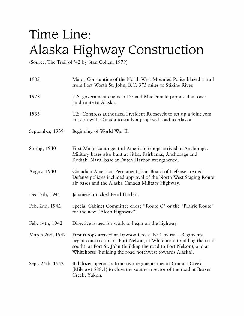
Time Line:Alaska Highway Construction(Source: The Trail of ’42 by Stan Cohen, 1979)
1905 Major Constantine of the North West Mounted Police blazed a trail from Fort Worth St. John, B.C. 375 miles to Stikine River.
1928 U.S. government engineer Donald MacDonald proposed an overland route to Alaska.
1933 U.S. Congress authorized President Roosevelt to set up a joint commission with Canada to study a proposed road to Alaska.
September, 1939 Beginning of World War II.
Spring, 1940 First Major contingent of American troops arrived at Anchorage. Military bases also built at Sitka, Fairbanks, Anchorage and Kodiak. Naval base at Dutch Harbor strengthened.
August 1940 Canadian-American Permanent Joint Board of Defense created.Defense policies included approval of the North West Staging Route air bases and the Alaska Canada Military Highway.
Dec. 7th, 1941 Japanese attacked Pearl Harbor.
Feb. 2nd, 1942 Special Cabinet Committee chose “Route C” or the “Prairie Route” for the new “Alcan Highway”.
Feb. 14th, 1942 Directive issued for work to begin on the highway.
March 2nd, 1942 First troops arrived at Dawson Creek, B.C. by rail. Regiments began construction at Fort Nelson, at Whitehorse (building the road south), at Fort St. John (building the road to Fort Nelson), and at Whitehorse (building the road northwest towards Alaska).
Sept. 24th, 1942 Bulldozer operators from two regiments met at Contact Creek (Milepost 588.1) to close the southern sector of the road at Beaver Creek, Yukon.
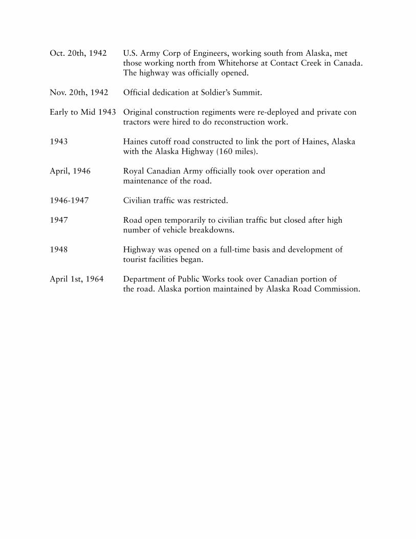
Oct. 20th, 1942 U.S. Army Corp of Engineers, working south from Alaska, met those working north from Whitehorse at Contact Creek in Canada. The highway was officially opened.
Nov. 20th, 1942 Official dedication at Soldier’s Summit.
Early to Mid 1943 Original construction regiments were re-deployed and private contractors were hired to do reconstruction work.
1943 Haines cutoff road constructed to link the port of Haines, Alaska with the Alaska Highway (160 miles).
April, 1946 Royal Canadian Army officially took over operation and maintenance of the road.
1946-1947 Civilian traffic was restricted.
1947 Road open temporarily to civilian traffic but closed after high number of vehicle breakdowns.
1948 Highway was opened on a full-time basis and development of tourist facilities began.
April 1st, 1964 Department of Public Works took over Canadian portion of the road. Alaska portion maintained by Alaska Road Commission.