alaska’s 2013 air monitoring network plan chapter 3
TRANSCRIPT

Air Quality Division
Air Monitoring
&
Quality Assurance
Program
619 E. Ship Creek Ave. #249
Anchorage, AK 99501
Phone: (907) 269-7577
Fax: (907) 269-7508
www.state.ak.us/dec/
Alaska’s 2013 Air Monitoring
Network Plan
Chapter 3
Fairbanks North Star Borough

Table of Contents
3 FAIRBANKS NORTH STAR BOROUGH MONITORING SITE DESCRIPTIONS ............. 1
3.1 General Information ......................................................................................................................... 1
3.2 OLD POST OFFICE SITE - FAIRBANKS ................................................................................... 4 3.2.1 Site Information ........................................................................................................................... 4 3.2.2 Sources ........................................................................................................................................ 4 3.2.3 Monitors ...................................................................................................................................... 5 3.2.4 Siting ........................................................................................................................................... 5 3.2.5 Traffic .......................................................................................................................................... 5
3.3 STATE OFFICE BUILDING - FAIRBANKS ............................................................................... 7 3.3.1 Site Information ........................................................................................................................... 7 3.3.2 Sources ........................................................................................................................................ 7 3.3.3 Monitors ...................................................................................................................................... 8 3.3.4 Siting ........................................................................................................................................... 8 3.3.5 Traffic .......................................................................................................................................... 8
3.4 NCORE – FAIRBANKS ................................................................................................................ 10 3.4.1 Site Information ..........................................................................................................................10 3.4.2 Sources .......................................................................................................................................10 3.4.3 Monitors .....................................................................................................................................10 3.4.1 Siting ..........................................................................................................................................11 3.4.2 Traffic .........................................................................................................................................11
3.5 NORTH POLE ELEMENTARY SITE ........................................................................................ 13 3.5.1 Site Information ..........................................................................................................................13 3.5.2 Sources .......................................................................................................................................14 3.5.3 Monitors .....................................................................................................................................14 3.5.4 Siting ..........................................................................................................................................14 3.5.5 Traffic .........................................................................................................................................14
3.6 NORTH POLE FIRE SITE ........................................................................................................... 16 3.6.1 Site Information ..........................................................................................................................16 3.6.2 Sources .......................................................................................................................................16 3.6.3 Monitors .....................................................................................................................................17 3.6.4 Siting ..........................................................................................................................................17 3.6.5 Traffic .........................................................................................................................................17

List of Figures Table 3.1:1 SLAMS and SPM sites in the Fairbanks North Star Borough ......................................................................... 2 Figure 3.1:1 Map of the Fairbanks and North Pole Area. Red dots indicate the locations of the monitoring sites. ......... 3 Figure 3.2:1 Map and satellite image of the Old Post Office monitoring site. The red circles indicate the site location. 4 Figure 3.3:1 Map and satellite image of the State Office Building. The red dot and circle indicate the site location. ..... 7 Figure 3.3.2: Pictures of the State Office Building ............................................................................................................ 9 Figure 3.4:1 Map and new shelter of the NCore monitoring site. The red dot indicates the site location. ......................10 Figure 3.4:2 Pictures of the NCore monitoring site. .........................................................................................................12 Figure 3.6:1 Map of the North Pole Elementary monitoring site. The red square indicates site location. ......................13 Figure 4.8.2: Pictures of the North Pole Elementary Site ................................................................................................15 Figure 3.7:1 Map of the North Pole Fire #3 monitoring site. The red square indicates site location. (Site map courtesy
of Google Maps) ................................................................................................................................................................16 Figure 4.8.2: Pictures of the North Pole Fire Site ...........................................................................................................18
List of Tables Table 3.1:1 SLAMS and SPM sites in the Fairbanks North Star Borough ......................................................................... 2

Chapter 3 – Fairbanks 2013 1
3 FAIRBANKS NORTH STAR BOROUGH MONITORING
SITE DESCRIPTIONS
3.1 General Information
Fairbanks, population1 31,535, is the second largest city in Alaska and is located within the
Fairbanks North Star Borough (FNSB) that has a population of 97,581. Fairbanks is situated on the
banks of the Chena River in the upper Tanana Valley of Interior Alaska. Interior Alaska
experiences seasonal temperature extremes. The average temperatures range from -2 F to -19 F in
the winter and from 53 F to 72 F in the summer. Temperatures have been recorded as low as -78 F
in mid-winter, and as high as 93 F in summer. Average annual precipitation is 11.3 inches. Ice fog
is common during the winter. Fairbanks experiences 21 hours of direct daylight between May 10th
and August 2nd each summer, and less than four hours of daylight between November 18th and
January 24th each winter.
Fairbanks was designated non-attainment for carbon monoxide (CO) on November 15, 1990. The
community developed a rigorous Inspection and Maintenance (I&M) program to reduce tail pipe
emissions from automobiles and the EPA required automobile manufacturers to reduce
environmental pollution, both of which have helped improve area air quality in the Fairbanks North
Star Borough. Not having had any CO exceedances for several years, Fairbanks requested re-
designation and was placed in CO maintenance status on July 23, 2004. Appendix A lists the
definitions of each designation.
The FNSB Air Program operates and manages six monitoring stations: one State and Local Air
Monitoring Site (SLAMS) for CO, one SLAMS site for PM2.5, one Speciation Trend Network
(STN) site, and three Special Purpose Monitoring (SPM) sites for PM2.5. The FNSB SLAMS, STN,
and SPM sites are identified below in Table 3-1:1. Appendix B lists siting criteria for each type of
monitoring site.
The Fairbanks and North Pole monitoring sites are located within the Northern Alaska Air Quality
Control Region and the Fairbanks non-attainment area. Figure 3-1:1 is a map showing the entire
Fairbanks and North Pole area. The red dots indicate the locations of the six monitoring sites.
Fairbanks is bordered by hills to the north and west, with the flats opening up to the south and east.
1 Population data obtained from 2010 US Census (April 1, 2011).

Chapter 3 – Fairbanks 2013 2
Table 3.1:1 SLAMS and SPM sites in the Fairbanks North Star Borough
PM2.5
Site Name Location AQS ID Designation Install Date Scale
State Office
Building
Fairbanks 02-090-0010 SLAMS/STN Oct, 1998 neighborhood
North Pole
Elementary
North Pole 02-090-0033 SPM Nov, 2008 neighborhood
NCore Fairbanks 02-090-0034 SPM Oct, 2009 neighborhood
North Pole
Fire
North Pole not available SPM Mar, 2012 neighborhood
CO
Site Name Location AQS ID Designation Install Date Scale
Old Post
Office
Fairbanks 02-090-0002 SLAMS Jan, 1972 micro

Chapter 3 – Fairbanks 2013 3
Pole Elementary
Figure 3.1:1 Map of the Fairbanks and North Pole Area. Red dots indicate the locations of the monitoring sites.
NCore Site
State Office Bldg Old Post Office
North Pole Elementary
North Pole Fire
ddDepartment
Elementary

Chapter 3 – Fairbanks 2013 4
3.2 OLD POST OFFICE SITE - FAIRBANKS
250 Cushman Street AQS ID 02-090-0002
Parameters: CO Established: January 1, 1972
3.2.1 Site Information
The site is located in the Old Post Office building at 250 Cushman Street at latitude 64 50’ 43”
north (64.845278), longitude 147 43’ 16” west (-147.721111), and elevation of 140 meters (460
feet) above sea level. Figure 3.2:1 shows a street map of downtown Fairbanks and satellite image
of the area. The site is located in the middle of the central business district. The Old Post Office is a
micro-scale, population-oriented site located in downtown Fairbanks.
Figure 3.2:1 Map and satellite image of the Old Post Office monitoring site. The red circles
indicate the site location.
3.2.2 Sources
The dominant source of CO emissions for this site is automobile exhaust. Within 200 meters of the
site, land use is predominantly business (generally medical practices and small offices) with some
small single family dwellings. Many older downtown houses have chimneys and may be using
woodstoves in the winter for supplemental heat. The Alaska Railroad industrial area (north) and the
Aurora Energy coal-fired power plant (west) are both located within one mile of the site. Coal-fired
power plants operated by UAF (to the west) and Fort Wainwright Army Post (to the east) are
located within five miles. Fairbanks is regularly impacted by wildland fire smoke in the summer
months.

Chapter 3 – Fairbanks 2013 5
3.2.3 Monitors
The Old Post Office site is currently equipped with:
CO (SLAMS) – A single Thermo Electron 48C CO monitor operates seasonally (October
through March) with an inlet approximately 3 meters above the ground.
3.2.4 Siting
The Old Post Office is located between 2nd
and 3rd
Avenues on the west side of Cushman Street.
The probe passes through the eastern exterior wall and extends out one meter at a height of two
meters above the ground. The inlet is three meters from the nearest traffic lane on Cushman Street,
and ten meters (32 feet) from the intersection at 2nd
Avenue. There are no parking lots in the
vicinity of the probe, but there is parallel parking on both 2nd
and 3rd
Avenues.
3.2.5 Traffic
This site is located at one of the busiest intersections in downtown Fairbanks. Traffic within one
mile of the site shows annual average daily traffic counts ranging from 1,013 to 9,227 vehicles. The
nearest traffic count site shown on the Department of Transport 2009 Traffic Map is on Cushman
between 1st and 2
nd Avenues with an annual average daily traffic count of 8,309 vehicles.
2
2 State Department of Transportation and Public Facilities, 2009 traffic maps,

Chapter 3 – Fairbanks 2013 6
Figure 3.2:3 Pictures of the Old Post Office Site
North East South
Views in three cardinal directions from the Old Post Office Site
North South West
Views in three cardinal directions toward the Old Post Office Site

Chapter 3 – Fairbanks 2013 7
3.3 STATE OFFICE BUILDING - FAIRBANKS
675 Seventh Avenue AQS IDs 02-090-0010
Parameters: PM2.5 Established: January 1, 1972
3.3.1 Site Information
The site is located on the roof of the State Office Building at 675 7th
Avenue. The latitude is 64
50’ 27” north (64.840833), longitude is 147 43’ 23” west (-147.723056), and elevation is140
meters (460 feet) above sea level. Figure 3.3:1 shows a street map of the downtown Fairbanks
area and satellite image of the area. The site is located in the middle of the central business
district. This is a neighborhood-scale, population-oriented PM2.5 site.
Figure 3.3:1 Map and satellite image of the State Office Building. The red dot and circle
indicate the site location.
3.3.2 Sources
The dominant source of PM2.5 for this site changes from season to season. During the long
winter months the primary sources of PM2.5are home heating, vehicle exhaust, and wood smoke.
During the summer months, the main source is wildland fire smoke.

Chapter 3 – Fairbanks 2013 8
3.3.3 Monitors
The State Office Building site is currently equipped with:
PM2.5 (SLAMS) – Two Thermo Electron (formerly Rupprecht & Patashnick) Partisol
2000 samplers. One sampler runs on a 1-in-3 day sampling schedule with the second
operating as a collocated monitor once every 6th
day,
PM2.5 (SPM) – A single Met-One BAM 1020X FEM was installed to provide information
in real time for calculating the Air Quality Index,
PM2.5 (STN) – A single Met-One Super SASS Speciation Monitor. This multi filter
sampler is set to sample on a 1-in-3 day sampling schedule,
PM2.5 (STN) – A single URG 3000N Speciation Monitor. This single filter sampler is set
to sample on a 1-in-3 day sampling schedule,
Surface meteorology for wind speed/direction.
Two of the monitors provide speciation data for fine particulate are shown with a STN
designation, an acronym for Speciation Trend Network.
3.3.4 Siting
The equipment is located on the west end of the State Office Building’s first story roof. The
inlets for all samplers are approximately six meters above the ground. There is unrestricted
airflow around the samplers. The building has a partial second floor that is approximately 3.75
meters higher than the roof the samplers sit upon. The nearest second floor wall is
approximately thirty meters west of the samplers. There is a birch tree approximately ten meters
south of the samplers; its height exceeds that of the inlets.
3.3.5 Traffic
This site is located in downtown Fairbanks with numerous roads within one mile of the site.
Area roads have daily traffic counts ranging from 1,013 to 9,227 vehicles. The nearest traffic
count site on 7th
Avenue shows an annual average daily traffic count of 1,248 vehicles and the
traffic count site on Barnette Street near 7th
Avenue shows an annual average daily traffic count
of 3,868 vehicles3. There are no parking lots in the vicinity of the probe, but there is parallel
street parking on 7th
Ave.
3 State Department of Transportation and Public Facilities, 2009 traffic maps,

Chapter 3 – Fairbanks 2013 9
Figure 3.3.2: Pictures of the State Office Building
North East South West
Views in four directions from the State Office Building
Not available, equipment in
close proximity to edge of
the roof
Views in four directions towards the State Office Building Site

Chapter 3 – Fairbanks 2013 10
3.4 NCORE – FAIRBANKS
809 Pioneer Road AQS ID: 02-090-0034
Parameters: Multi-Pollutant Site Established: October 29, 2009
(PM10-2.5, PMC, SO2, NOY, NO, NH3, CO, O3, and Met)
3.4.1 Site Information
The site is located near the Fairbanks North Star Borough building on Pioneer Road at latitude of
64 50 44.6 north (64.845690), longitude of 147 43 38.2 west (-147.727413), and elevation
of 472 feet (144 meters) above sea level. Figure 3.4:1 shows a street map and the satellite image
of the local area. This is a neighborhood-scale, population-oriented site.
Figure 3.4:1 Map and new shelter of the NCore monitoring site. The red dot indicates the
site location.
3.4.2 Sources
The dominant source of PM2.5 for this site changes from season to season. The source
contribution to winter time PM2.5 is still being studied. Wood smoke from home heating is
currently considered one of the major sources. During the summer months, the main source is
wildland fire smoke.
3.4.3 Monitors
The NCORE monitoring site is currently equipped with:
PM2.5 (SPM) – One Thermo Electron (formerly Rupprecht & Patashnick) Partisol 2000
sampler on a 1-in-3 day alternating sampling schedule.
PM10 / PM2.5 /PMCoarse (SPM) – Dual Met-One Inc., BAM 1020X FEM continuous monitors
which include one continuous sampler for PM10 and one continuous sampler for PM2.5.
PMCoarse is calculated by subtracting the PM2.5 value from the PM10 value. DEC uses the data

Chapter 3 – Fairbanks 2013 11
to calculate an Air Quality Index for forecasting local air quality conditions and for reporting
to the EPA Air Quality System (AQS) data base.
Carbon Monoxide (CO) – Thermo Scientific Model 48i-TLE continuous CO monitor
Sulfur Dioxide (SO2) - Thermo Scientific Model 43i-TLE continuous SO2 monitor
PM2.5 (STN) – A single Met-One Super SASS Speciation Monitor
Ozone (O3) - Teledyne Model 403E continuous O3 monitor
Ammonia (NH3) - Thermo Scientific Model 17i continuous NH3 monitor
Surface meteorology for wind speed/direction, ambient temperature, and barometric pressure
Data collection began November 2, 2011.
In December 2010, the NCORE monitoring site was expanded with the purchase and installation
of a new temperature-controlled shelter. The shelter was designed for operation in sub-Arctic
conditions with higher rated insulation and an Arctic entry. Additional trace-level gas monitors
are being installed and scheduled to be operational by mid-June 2012. The additional monitors
include:
Nitrogen oxide (NO) - Thermo Scientific Model 42i-TLE continuous NO monitor
(delayed due to instrument problems requiring factory repairs, scheduled for start-up in
mid June)
Total reactive nitrogen (NOy) - Thermo Scientific Model 42i-Y continuous NOy monitor
(delayed due to instrument problems requiring factory repairs, scheduled for start-up in
mid-June)
3.4.1 Siting
DEC decided to locate the NCORE multi-pollutant monitoring site in Fairbanks because
Fairbanks is dealing with the most significant air quality impacts in the state. Details of the
technical site selection process are provided in Appendix G.
The site is located approximately 35 meters north of the Chena River near the Fairbanks North
Star Borough Building. There is a small patch of birch trees 6 to10 meter tall that sit
approximately 32 meters to the east of the site. The heights of the trees exceed the height of the
monitor inlets. There is a 12 meter tall building approximately 75 meters to the southeast of the
site and a 7 meter tall building approximately 50 meters to the west.
3.4.2 Traffic
This site is located in downtown Fairbanks with numerous roads within one mile of the site. The
downtown Fairbanks area has annual average daily traffic counts ranging from 1,031 to 9,227
vehicles with the closest counting site on First Avenue (directly across the river) at 3,559
vehicles4. There are parking lots in the vicinity of both adjacent buildings.
4 State Department of Transportation and Public Facilities, 2009 traffic maps

Chapter 3 – Fairbanks 2013 12
Figure 3.4:2 Pictures of the NCore monitoring site.
North East South West
Views in four directions from the NCore site
Views in four directions towards the NCore site

Chapter 3 – Fairbanks 2013 13
3.5 NORTH POLE ELEMENTARY SITE
250 Snowman Lane AQS ID: 02-090-0033
Parameters: PM2.5, WS/WD, Temp, Chemical Speciation, Established: Dec. 20, 2008
Black Carbon
3.5.1 Site Information
The site is located at the North Pole Elementary School on the east side of the parking lot at a
latitude of 64° 45' 8.41” north (64.752336), longitude of 147° 20’ 49.95” west (-147.347208),
and elevation of 146 meters (479 feet) above sea level. Figure 4.8:1 shows a street map of the
local area. This is a neighborhood-scale, population-oriented site.
Figure 3.6:1 Map of the North Pole Elementary monitoring site. The red square indicates
site location.

Chapter 3 – Fairbanks 2013 14
3.5.2 Sources
The dominant source of PM2.5 for this site changes from season to season. The source
contribution to winter time PM2.5 is still being studied. Wood smoke from home heating is
currently considered one of the major sources. During the summer months, the main source is
wildland fire smoke. The goals of the FNSB Winter Monitoring Project conducted during the
winters of 2008-09, 2009-10, and 2010-11 are to evaluate wintertime pollutant characteristics
and develop a strategy to reduce the concentration in North Pole.
3.5.3 Monitors
The North Pole Elementary site is currently equipped with:
PM2.5 (SPM) – One Thermo Electron (formerly Rupprecht & Patashnick) Partisol 2000
sampler on a 1-in-3 day alternating sampling schedule.
PM2.5 (SPM) – A single Met-One BAM 1020X FEM was installed to provide information in
real time for calculating the Air Quality Index.
PM2.5 (SPM wintertime only) – A single Met-One Super SASS Speciation Monitor. This
multi-filter sampler is set to sample on a 1-in-3 day sampling schedule.
Wind Speed/Wind Direction/Ambient Temperature - MetOne Sonic Anemometer Model
50.5H and a Met-One BX 592-2 temperature sensor.
3.5.4 Siting
The North Pole Elementary School site is located on the eastside parking lot of North Pole
Elementary School on Snowman Lane. The monitoring instrumentation is housed in a self-
contained monitoring shelter. The sample inlets extend above the roof of the shelter at
approximately 4 meters above ground level.
3.5.5 Traffic
The site is within approximately 1000 feet (300 meters) of the Richardson Highway. Land use
within a 400 meter radius of the site is a mixture of commercial, industrial, and residential.
Annual average daily traffic estimated along the Richardson Highway through North Pole is
10,875 vehicles. Annual average daily traffic along Snowman Lane is unknown but the nearest
traffic site along South Santa Claus Lane averages 4,126 vehicles.5
5 State Department of Transportation and Public Facilities, 2009 traffic maps,

Chapter 3 – Fairbanks 2013 15
Figure 4.8.2: Pictures of the North Pole Elementary Site
North East South West
Views in four directions from the North Pole Elementary Site
Views in four directions towards the North Pole Elementary Site

Chapter 3 – Fairbanks 2013 16
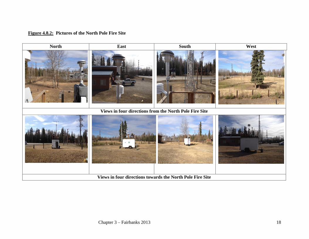
3.6 NORTH POLE FIRE SITE
3288 Hurst Rd AQS ID: n/a
Parameters: PM2.5, WS/WD, Temp, Chemical Speciation, Established: Mar. 1, 2011
Black Carbon
3.6.1 Site Information
The site is located at the North Pole Fire Station #3 on the west side of the Fire Station at a
latitude of 64° 45' 46.7” north (64.762973), longitude of -147° 18’ 37.0” west (-147.310297),
and elevation of 145 meters (475 feet) above sea level. Figure 3.7:1 shows a street map of the
local area. This is a neighborhood-scale, population-oriented site. An AQS site code is yet to be
established for this location.
Figure 3.7:1 Map of the North Pole Fire #3 monitoring site. The red square indicates site
location. (Site map courtesy of Google Maps)
3.6.2 Sources
The dominant source of PM2.5 for this site changes from season to season. The source
contribution to winter time PM2.5 is still being studied. Wood smoke from home heating is
currently considered one of the major sources. During the summer months, the main source is
wildland fire smoke. The goals of the FNSB Winter Monitoring Project conducted during the
winters of 2008-09, 2009-10, and 2010-11 are to evaluate wintertime pollutant characteristics
and develop a strategy to reduce the concentration in North Pole. Preliminary studies suggest that
this new site might be more representative of the North Pole neighborhood scale pollutant levels.

Chapter 3 – Fairbanks 2013 17
3.6.3 Monitors
The North Pole Fire site is currently equipped with:
PM2.5 (SPM) – One Thermo Electron (formerly Rupprecht & Patashnick) Partisol 2000
sampler on a 1-in-3 day alternating sampling schedule.
PM2.5 (SPM) – A single Met-One BAM 1020X FEM was installed to provide information in
real time for calculating the Air Quality Index
PM2.5 (SPM wintertime only) – A single Met-One Super SASS Speciation Monitor. This
multi-filter sampler is set to sample on a 1-in-3 day sampling schedule.
Wind Speed/Wind Direction/Ambient Temperature - MetOne Sonic Anemometer Model
50.5H and a Met-One BX-592-2 Ambient Temperature Sensor.
3.6.4 Siting
The North Pole Fire Station site is located on the west side of North Pole Fire Station #3 at 3288
Hurst Rd. The monitoring instruments are housed in a self-contained monitoring shelter. The
sample inlets extend above the roof of the shelter at approximately 4 meters above ground level.
3.6.5 Traffic
The site is within approximately 75 feet (23 meters) of Hurst Road. It is also 280 feet (85 meters)
from the intersection of Hurst Road and Dawson Road. Land use within a 400 meter radius of
the site is mixture of residential and light agricultural. Annual average daily traffic estimated
along the Richardson Highway through North Pole is 10,875 vehicles. Annual average daily
traffic along Hurst Rd is 3730 is vehicles.6
6 State Department of Transportation and Public Facilities, 2010 traffic maps
Chapter 3 – Fairbanks 2013 18
Figure 4.8.2: Pictures of the North Pole Fire Site
North East South West
Views in four directions from the North Pole Fire Site
Views in four directions towards the North Pole Fire Site