airport briefing - sallés hotels · 2019-01-17 · airport facilities fuel: yes, to arrange fuel...
TRANSCRIPT

A I R P O RT B R I E F I N G
ICAO code: LENE-CIUDAD REALLA CAMINERA
Airport Elevation 2513´ / 766m
GEOGRAPHIC DATA AND AERODROME ADMINISTRATION
ARP: N 38° 40’ 10,993’’ W 3° 18’ 12,407’’W
Elevation: 2513´/ 766 m
Magnetic Deviation: Date 01/01/2015 Declination 53' [WEST] Variation
Secular 7.2' [EAST]
Aerodrome Management: Promociones SAGEMAR S.A.
Type of Air�eld: Restrictive/Private Airport
Address: Camino de Altamar, s/n, 13740 Torrenueva, Ciudad Real
Contact Persons: Airport Manager Mr. Carlos Camacho +34 610 745 302 / Hotel Director Mr. Juan José Martínez +34 619 788 054 - +34 926 344 733
Notes: Flight Authorisation Required by email to [email protected]
“La Caminera” is a private, restrictive and visual airport owned by the company SAGEMAR S.A. and located inside the facilities of “Hotel Golf and Spa Resort***** La Caminera” at 33 NM South East from Ciudad Real.
BEFORE TO FLY LA CAMINERA:
Mandatory Permission
Before to operate to La Caminera the operator/airplane´s owner must request the permission from Management. In order to apply you must �ll two Forms (see �les attached).
a) Landing Request Form. See ANNEX 1b) Liability Release Form. See ANNEX 2
Both forms must be signed and send by email to Mr Carlos Camacho [email protected] at least 72 hours before the date �ight.Once reviewed by Airport Management you will receive back an Authorization letter signed and stamped by the Hotel Administration Department.
Airport Opening Time
From Sunrise to Sunset.
EASA regulation
VMC conditions/VFR �ight: 5000 meters of visibility and Ceiling 1500 feet. Area Airspace classi�cation: GRunway classi�cation: 2BArrival FPL: YDeparture FPL: ZVFR XPDR 7000 until assigned by Seville ATC.Altimeter Setting: Albacete LEAB is the closest Airport and could be used as reference until Seville contact establish by frequency.
Radio frequency
VHF 123.50 Mhz.
ATC requirement
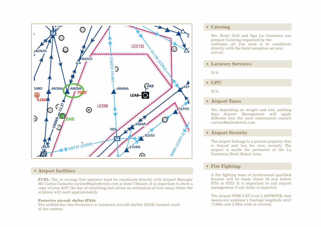
Arrival:Approaching ANZAN @ 7000 feet if in VFR conditions acceptable, pilots should ask Seville ATC to cancel IFR and proceed VFR to La Caminera for landing.After engine shutdown pilot must advice operations of his company to close FPL calling Córdoba +34 957214107 if landing is done before 15:00 local time or, Seville + 34 954449202 if landing is done after 15:00. SEE MAP BELOW
Departures:15 minutes before ETD a call must be made to Seville ATC Tel +34 954555416 to con�rm the ETD and request a transponder code and an initial FL. When airborne, above 6000 feet, pilot must call Seville ATC freq. 132.675 for further instructions.
Airport facilities
FUEL: Yes, to arrange fuel operator must be coordinate directly with Airport Manager Mr Carlos Camacho [email protected] at least 72hours. It is important to show a copy of your AOC the day of refuelling and advise an estimation of how many litters the airplane will need approximately.
Protective aircraft shelter (PAS): The air�eld has like Protective or hardened aircraft shelter (HAS) located southof the runway.
Catering
Yes, Hotel Golf and Spa La Caminera can prepare Catering requested by thecustomer, all you need is to coordinate directly with the hotel reception on yourarrival.
Lavatory Services:
N/A
GPU
N/A
Airport Taxes
Yes, depending on weight and size, parking days Airport Management will apply different fees. For more information contact [email protected]
Airport Security
The airport belongs to a private property that is fenced and has his own security. The airport is inside the perimeter of the La Caminera Hotel Resort Area.
Fire Fighting:
A �re �ghting team of professional quali�ed �remen will be ready about 30 min before ETA or ETD. It is important to call airport management if any delay is expected.
The airport FIRE CAT level 3 APPROVE, that means any airplane´s fuselage longitude until 17,99m and 2,99m wide is covered.

Runway
DIMENSIONSObservations:
08 MAG: 079° 1400x23 38°40’ 6,59 ‘’ N 3°18‘ 38,71 ‘’ W 779,10
26 MAG: 259° 1400x23 38°40’ 16,06 ‘’ N 3°17’ 42,05 ‘’ W 779,59
Orientation DIM (m)
1520x80
1520x80
Franja (m)UMBRAL PSN UMBRAL ELEV (m)
RUNWAY CHARACTERISTICS
RUNWAY DETAILS
APPRON
APPRON DIMENSIONS: 30 m wide: 70 m Pavement: Concrete Resistance: PCN 20/F/B/X7/T
Parking Positions: 2
Taxiways dimensions: 54 m wide: 14 m Pavement: Same to the runway.
Resistance: Same to the runway 1,5%
Slope transversal: 1,5% both sides
Pro�le:
Longitudinal: DOWNSLOPE 2% for the �rst 710 m of runway (from RWY 08 to RWY 26) and UPSLOPE 2% for 690m
RWY
08 1400 1400 1400 1400
26 1400 1400 1400 1400
TORA (m) TODA (m) ASDA (m) LDA (m)
RUNWAY DISTANCES

The closest airports to La Caminera that may be consider as alternates destination airports are:
1 ALBACETE: Los Llanos – LEAB – 70.4 NM East from LENE One Runway (09 – 27) 2699m 2 ILS

2 GRANADA: Federico García Lorca – LEGR – 91.7 NM South. One Runway (09 – 27) 2900m 1 ILS
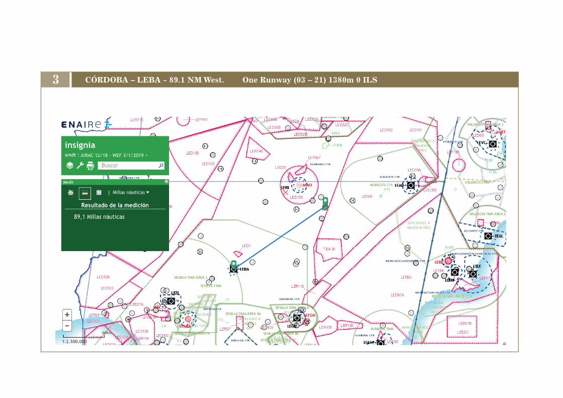
3 CÓRDOBA – LEBA - 89.1 NM West. One Runway (03 – 21) 1380m 0 ILS

1. During approach procedure it is important DO NOT CONFUSE with theairport La Perdiz (LEIZ) located 9,6 NM Southwest from “La Caminera”.
2. Pay special attention to LED98, check NOTAMS and DO NOT OVERFLY when is active. Spanish Air Force �ghters exercises in progress could be. If by mistake you penetrate this zone during descend/approach inform ATC as soon as possible. SEE MAP BELOW.
Threat Error Management TEM
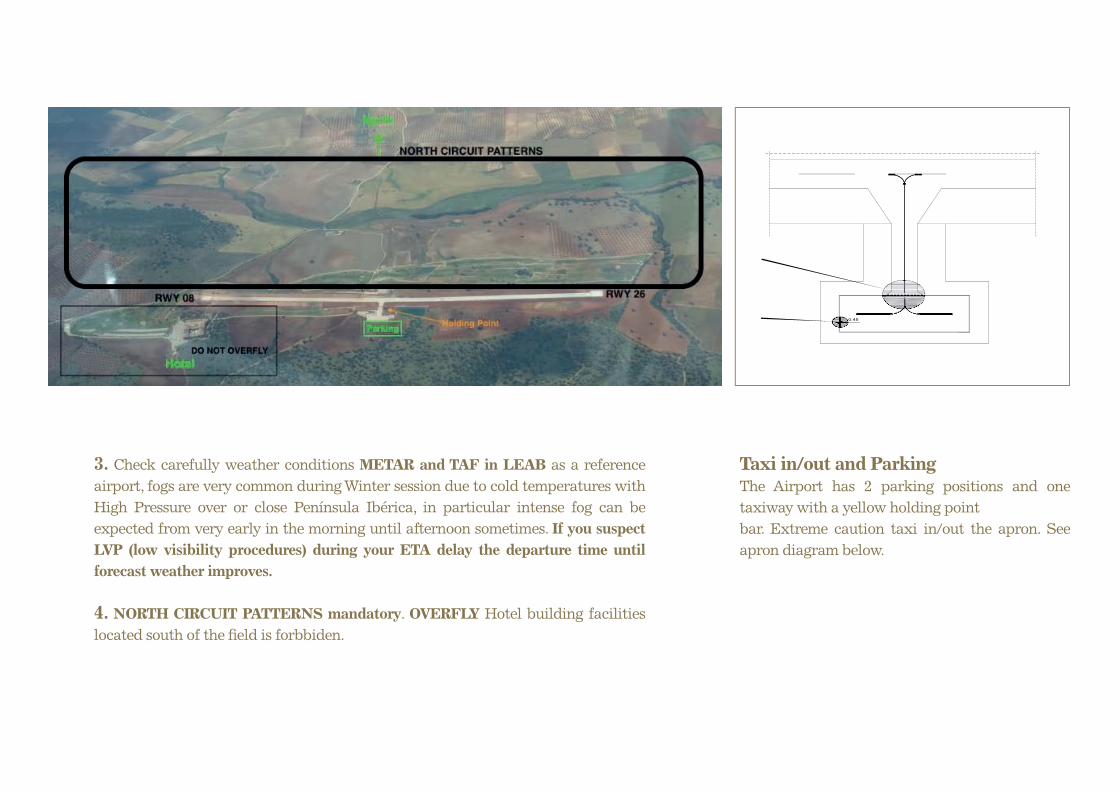
3. Check carefully weather conditions METAR and TAF in LEAB as a reference airport, fogs are very common during Winter session due to cold temperatures with High Pressure over or close Península Ibérica, in particular intense fog can be expected from very early in the morning until afternoon sometimes. If you suspect LVP (low visibility procedures) during your ETA delay the departure time until forecast weather improves.
4. NORTH CIRCUIT PATTERNS mandatory. OVERFLY Hotel building facilities located south of the �eld is forbbiden.
Taxi in/out and ParkingThe Airport has 2 parking positions and one taxiway with a yellow holding pointbar. Extreme caution taxi in/out the apron. See apron diagram below.
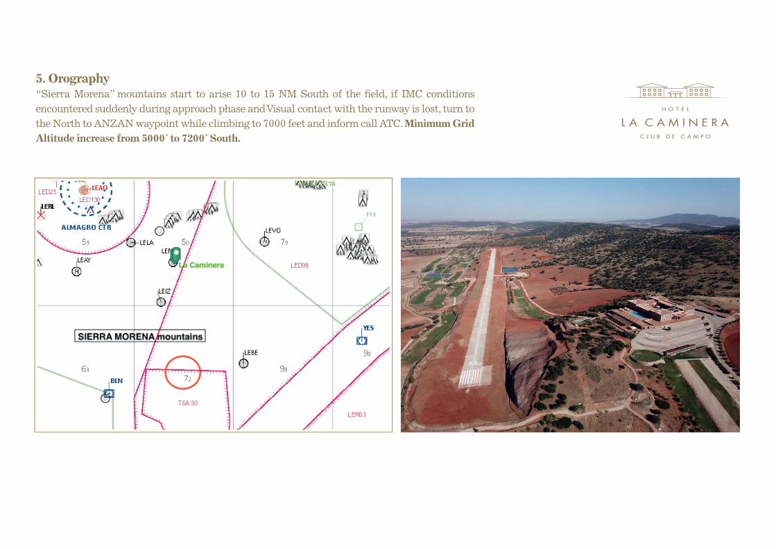
5. Orography “Sierra Morena” mountains start to arise 10 to 15 NM South of the �eld, if IMC conditions encountered suddenly during approach phase and Visual contact with the runway is lost, turn to the North to ANZAN waypoint while climbing to 7000 feet and inform call ATC. Minimum Grid Altitude increase from 5000´ to 7200´ South.

Tel. +34 926 344 [email protected] - www.hotellacaminera.com