air masses source region type of air symbolteachers.sduhsd.net/jhonsberger/packet 12 2009.pdf ·...
TRANSCRIPT

1
Packet #12: Weather & Climate Name: _______________________________ Per: ______ Reading Guide: Chapter 24.1 (Read and study text pages 601-604)
Understanding Air Masses 5a. Students know how differential heating of Earth results in circulation patterns in the atmosphere and oceans that globally distribute the heat. 6a. Students know weather (in the short run) and climate (in the long run) involve the transfer of energy into and out of the atmosphere.
1. What causes differences in air pressure? 2. Explain how and why air moves?
3. What is an air mass?
4. Fill in the table about the 4 different types of air masses.
Air Masses Source Region Type of Air Symbol
5. Describe the differences between a continental air mass & a Maritime air mass. 6. Describe the differences between a Tropical air mass & a Polar air mass:
7. Fill in the table below about the Air Masses of North America: Air Mass Source location Movement Weather
8. Which air mass brings dry hot weather to the Central US in the Summer? 9. Which air mass brings warm and moist air to southern California?
10. Which air mass brings cold dry air to the great lakes region in the Winter?
11. Which air mass brings cold wet air to northern California in the Winter?
2
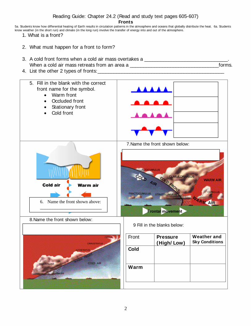
Reading Guide: Chapter 24.2 (Read and study text pages 605-607) Fronts
5a. Students know how differential heating of Earth results in circulation patterns in the atmosphere and oceans that globally distribute the heat. 6a. Students know weather (in the short run) and climate (in the long run) involve the transfer of energy into and out of the atmosphere.
1. What is a front? 2. What must happen for a front to form?
3. A cold front forms when a cold air mass overtakes a _______________________________.
When a cold air mass retreats from an area a _________________________________forms. 4. List the other 2 types of fronts:_______________________________________________
5. Fill in the blank with the correct
front name for the symbol. • Warm front • Occluded front • Stationary front • Cold front
7.Name the front shown below: _________________________
8.Name the front shown below:
9 Fill in the blanks below:
Front Pressure
(High/Low) Weather and Sky Conditions
Cold
Warm
6. Name the front shown above: _________________________
3
Reading Guide: Chapter 24.2 (Read and study text pages 608-609) Severe Weather
6a. Students know weather and climate involve transfer of energy into and out of the atmosphere. 1.Describe Severe weather:
2. Define Thunderstorms:
3. How does lightning form?
4a. Where do hurricanes develop? 4b. Described a fully developed hurricane:
5. Describe a tornado?
6. How and where do tornadoes form?
Reading Guide: Chapter 25.1 (Read and study text pages 631-636) Factors that Affect Climate
5g. Students know features pf the ENSO cycle. 6b. Students know the effects on climate of latitude, elevation, topography, and proximity to large bodies of water.
1. Define Climate:
2. Climates are chiefly described by:
3. When describing climates, extremes of ___________________ & __________________ as well as _______________________ have to be ______________________________.
4. Different latitudes receive different amounts of solar energy. Solar energy determines the ______________ and wind pattern of an are, which influences the _____________________________________________ _____________________________________________
5. Describe the amount of solar energy an area at a high latitude receives and why this happens:
6a. Describe the wind belts that form near the poles: 6b. Describe the wind belts that form near the equator:
7. Describe the Doldrums (pressure, temperature, precipitation):
8. Land heats up faster than water, explain why water stays cooler:
9. Define Specific Heat:
10. How do ocean currents affect air temperature?
11. What cycle does El Nino-Southern Oscillation or ENSO describe?
12. List the characteristics of an El Nino:
13. Describe a Monsoon:
14. How does a rain shadow form?
4
Climate Zones- Reading Guide: Chapter 25.2 (Read and study text pages 637-640) 5e. Students know rain forests & deserts are distributed in bands at specific latitudes. 5f. Students know the interaction of wind patters, oceans, & mtns. Result in the global pattern of latitudinal bands of rain forests & deserts.
1a. Define Tropical Climates: 1b. What latitude do they occur between?_______ 1c. LABEL THE CLIMATE ZONE ON MAP pg 12
1d. List the 3 types of tropical climates:
2a. Define Middle-Latitude Climates: 2a What latitude do they occur between?__________ 2c. LABEL THE CLIMATE ZONE ON MAP pg 12
2d. List the 4 types of Middle-Latitude Climates:
3a. Define Polar Climates: 3b. What latitude do they occur between?__________ 3c. LABEL THE CLIMATE ZONE ON MAP pg 12
3d. List the 3 types of Polar Climates:
4a. Define microclimates: 4b. Describe the large bodies of water on microclimates:
Climate Change- Reading Guide: Chapter 25.3 (Read and study text pages 641-646) 6c. Students know how earth’s climate has changed over time corresponding to changes in earth’s geographical position and other factors, such as solar radiation and plate movement.
1a. Define Climatologists:
1b. List & describe how ice cores can tell us about the worlds past climate:
2a. How can the change in the tilt of earths axis affect our climate?
2b. How does human activity affect our climate?
3. Define global warming:
4. Scientists predict that an increase in global temperatures will cause the polar ice caps to melt. Why is this a problem?
5. What are some suggestions that the book lists that could help solve this problem?

5
Air Masses & Fronts
• What is an Air Mass? A __________________ that has uniform temperature & moisture content.
• How do air masses form? Air over a certain region takes on those ____________________.
• Where do the following air masses from? o Polar: ____________________ o Maritime: _____________________ o Tropical: _____________________ o Continental: ___________________
• Air mass temperature & moisture content: o Maritime polar Pacific: ______________ o Maritime tropical Pacific: ____________ o Continental polar: _________________ o Continental tropical: ______________
• How do air masses mix? o When air masses have different properties, ____________________! o They interact along a boundary called a _____________ (4 types):
Cold front Warm front Stationary front Occluded front
• COLD FRONT o What happens? Cold air advances on warm air and forces _______
__________________________ o Clouds? Large cumulus & cumulonimbus clouds. o Weather? _______________________. Squall line- heavy storms.
• WARM FRONT o What happens? Warm air advances on cold air and the _________
_______________________________ o Clouds? Clouds form a ____________________. Cirrus-cirrostratus-
altostratus-low stratus & nimbostratus. o Weather? _____________________ over a large area.
• STATIONARY FRONT o What happens? The warm air and cold air ___________________
against each other. o Weather? Similar to a ____________________.
• OCCLUDED FRONT o What happens? Fast moving cold front _______________ completely
off the ground. Cool air replaces the warm air and the cool front comes into contact with the new cool air.
6
SEVERE WEATHER THUNDERSTORMS What is a thunderstorm? A _______________ with thunder, lightning, and strong winds
How do they occur? (3 ways) • The _____________________ rises and forms a thunderstorm. • Air rises _____________ over the mountains and forms a thunderstorm. • A _______________________ moves through.
3 stages of a thunderstorm 1. ______________________- warm moist air rises and condenses as a cumulus cloud. 2. ______________stage- the cumulus cloud grows to a cumulonimbus cloud-torrential rain, hail stones. 3._______________ stage- strong down drafts stop the rising air and the thunderstorm dies. How does lightning occur?
• Positive charges & negative charges in __________________ • Positive charge ________________ • A spark forms between charges. • ___________ of lightning is in the cloud, only ____________ reaches the ground.
How does thunder form? • The electricity heats & cools the air, which causes it to _____________________________. • This produces a loud noise. • What do you do in a lightning storm? • Stay away from water, ______________________, and tall objects (trees). • Go inside a _____________________________ because the lightning is carried to the ground by the
exterior of the car or building. HURRICANES What are hurricanes? They are ______________________ with winds that exceed ___________ and blow counter-clockwise about their centers in the northern hemisphere, and clockwise in the southern hemisphere. Hurricane eye:
• A 20-50 km diameter region at the ______________________________ where skies are often clear and winds are light. The storm’s _____________ pressure readings are found here.
• Eye wall: a “wall” of clouds and intense thunderstorms that _____________________________. • Where and when do hurricanes form? • They form over tropical oceans where there are _________________, ____________________, and
converging winds. Equatorial regions. • The hurricane season: June to November when the water is ________________________________.
Hurricane stages/development:
•Low Pressure
•Clouds & rain
•Circular storm center
•Pressure drops in center
•Winds at least _________
•Stronger center
•More pressure drop
•Winds at least ________
•The eye develops
•Winds at least ___________
TORNADOES • The _________________, most _________________ and shortest-lived storms. • It is a whirling, _______________________ cyclone. How does a tornado form? • A thunderstorm that meets high-altitude _________________________. • The winds cause clouds to develop a spinning funnel. • Winds speeds can get up to ___________________! Tornado facts: • Average of 780 tornadoes occur each year in U.S. *Average diameter of 1/4 mile - 1 mile • Can occur all year long, but most are in _____________________. They can travel about __________
7
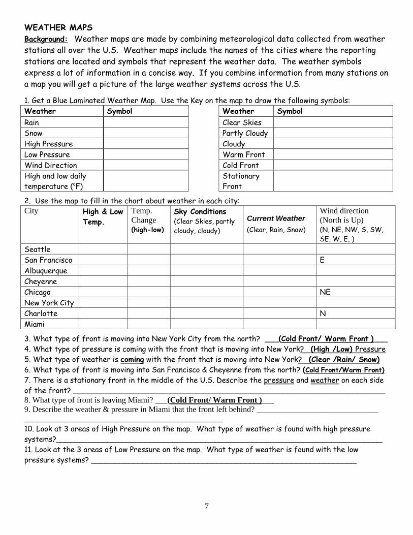
WEATHER MAPS Background: Weather maps are made by combining meteorological data collected from weather stations all over the U.S. Weather maps include the names of the cities where the reporting stations are located and symbols that represent the weather data. The weather symbols express a lot of information in a concise way. If you combine information from many stations on a map you will get a picture of the large weather systems across the U.S.
1. Get a Blue Laminated Weather Map. Use the Key on the map to draw the following symbols: Weather Symbol Weather Symbol Rain Clear Skies Snow Partly Cloudy High Pressure Cloudy Low Pressure Warm Front Wind Direction Cold Front High and low daily temperature (oF)
Stationary Front
2. Use the map to fill in the chart about weather in each city: City High & Low
Temp. Temp. Change (high-low)
Sky Conditions (Clear Skies, partly cloudy, cloudy)
Current Weather (Clear, Rain, Snow)
Wind direction (North is Up) (N, NE, NW, S, SW, SE, W, E, )
Seattle San Francisco E Albuquerque Cheyenne Chicago NE New York City Charlotte N Miami
3. What type of front is moving into New York City from the north? ___(Cold Front/ Warm Front )___ 4. What type of pressure is coming with the front that is moving into New York? (High /Low) Pressure 5. What type of weather is coming with the front that is moving into New York? (Clear /Rain/ Snow) 6. What type of front is moving into San Francisco & Cheyenne from the north? (Cold Front/Warm Front) 7. There is a stationary front in the middle of the U.S. Describe the pressure and weather on each side of the front? ___________________________________________________________________ 8. What type of front is leaving Miami? ___(Cold Front/ Warm Front )___ 9. Describe the weather & pressure in Miami that the front left behind? ______________________________ _________________________________________________ 10. Look at 3 areas of High Pressure on the map. What type of weather is found with high pressure systems?______________________________________________________________________ 11. Look at the 3 areas of Low Pressure on the map. What type of weather is found with the low pressure systems? _________________________________________________________
8
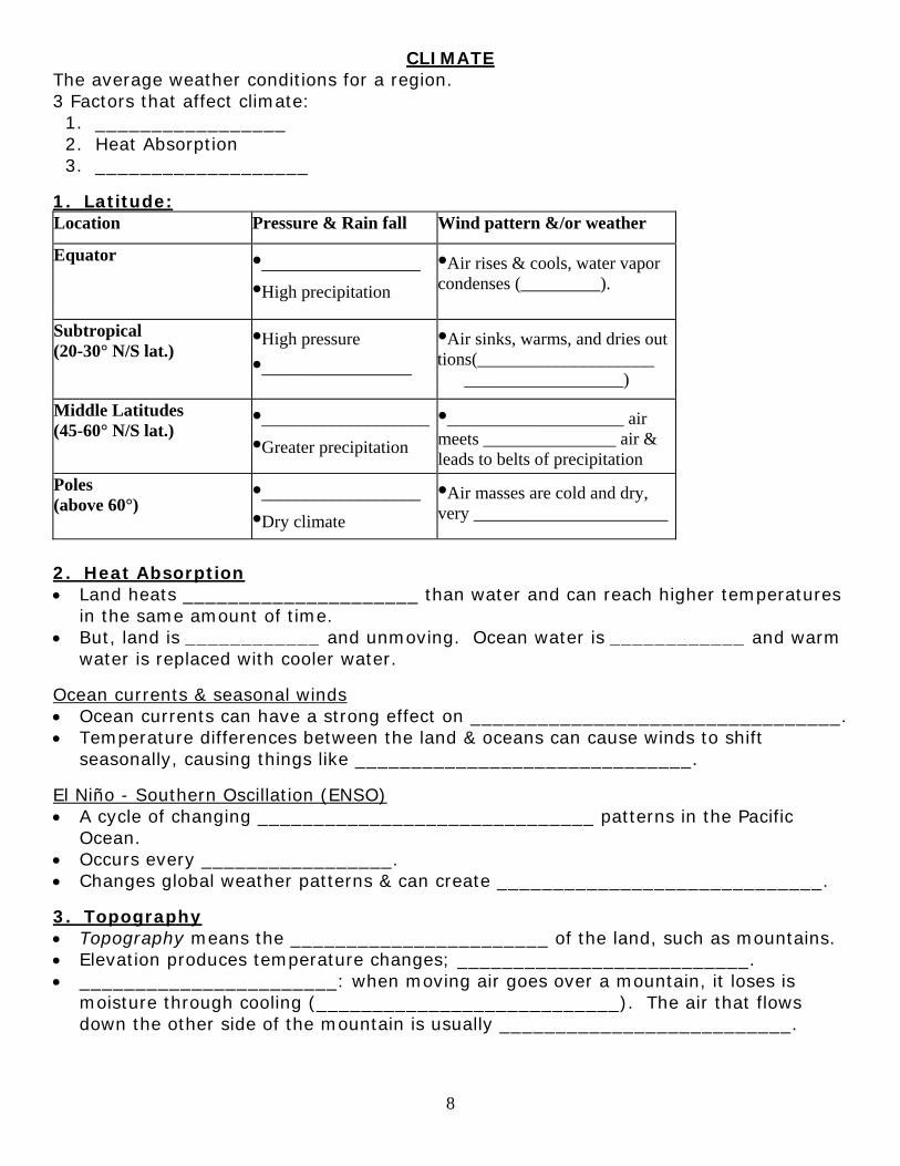
CLIMATE The average weather conditions for a region. 3 Factors that affect climate: 1. _________________ 2. Heat Absorption 3. ___________________
1. Latitude: Location Pressure & Rain fall Wind pattern &/or weather
Equator
•__________________ •High precipitation
•Air rises & cools, water vapor condenses (_________).
Subtropical (20-30° N/S lat.)
•High pressure •_________________
•Air sinks, warms, and dries out tions(____________________ __________________)
Middle Latitudes (45-60° N/S lat.)
•___________________•Greater precipitation
•____________________ air meets _______________ air & leads to belts of precipitation
Poles (above 60°)
•__________________ •Dry climate
•Air masses are cold and dry, very ______________________
2. Heat Absorption • Land heats _____________________ than water and can reach higher temperatures
in the same amount of time. • But, land is ____________ and unmoving. Ocean water is ____________ and warm
water is replaced with cooler water.
Ocean currents & seasonal winds • Ocean currents can have a strong effect on _________________________________. • Temperature differences between the land & oceans can cause winds to shift
seasonally, causing things like ______________________________.
El Niño - Southern Oscillation (ENSO) • A cycle of changing ______________________________ patterns in the Pacific
Ocean. • Occurs every _________________. • Changes global weather patterns & can create _____________________________.
3. Topography • Topography means the _______________________ of the land, such as mountains. • Elevation produces temperature changes; __________________________. • _______________________: when moving air goes over a mountain, it loses is
moisture through cooling (___________________________). The air that flows down the other side of the mountain is usually __________________________.
9
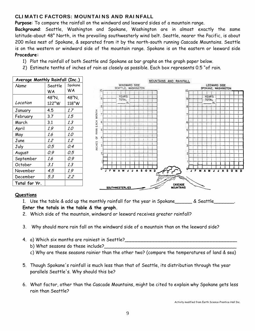
CLIMATIC FACTORS: MOUNTAINS AND RAINFALL Purpose: To compare the rainfall on the windward and leeward sides of a mountain range. Background: Seattle, Washington and Spokane, Washington are in almost exactly the same latitude-about 48° North, in the prevailing southwesterly wind belt. Seattle, nearer the Pacific, is about 200 miles nest of Spokane, & separated from it by the north-south running Cascade Mountains. Seattle is on the western or windward side of the mountain range. Spokane is on the eastern or leeward sideProcedure:
1) Plot the rainfall of both Seattle and Spokane as bar graphs on the graph paper below. 2) Estimate tenths of inches of rain as closely as possible. Each box represents 0.5 “of rain.
Average Monthly Rainfall (Inc.) Name Seattle
WA Spokane WA
Location 48°N, 122°W
48°N, 118°W
January 4.5 1.7 February 3.7 1.5 March 3.1 1.3 April 1.9 1.0 May 1.6 1.0 June 1.2 1.2 July 0.5 0.4 August 0.9 0.5 September 1.6 0.9 October 3.1 1.3 November 4.5 1.9 December 5.3 2.2 Total for Yr.
Questions 1. Use the table & add up the monthly rainfall for the year in Spokane______ & Seattle_______. Enter the totals in the table & the graph. 2. Which side of the mountain, windward or leeward receives greater rainfall? 3. Why should more rain fall on the windward side of a mountain than on the leeward side?
4. a) Which six months are rainiest in Seattle?_______________________________________
b) What seasons do these include?______________________________________________ c) Why are these seasons rainier than the other two? (compare the temperatures of land & sea)
5. Though Spokane's rainfall is much less than that of Seattle, its distribution through the year
parallels Seattle's. Why should this be? 6. What factor, other than the Cascade Mountains, might be cited to explain why Spokane gets less
rain than Seattle?
Activity modified from Earth Science-Prentice-Hall Inc.
10
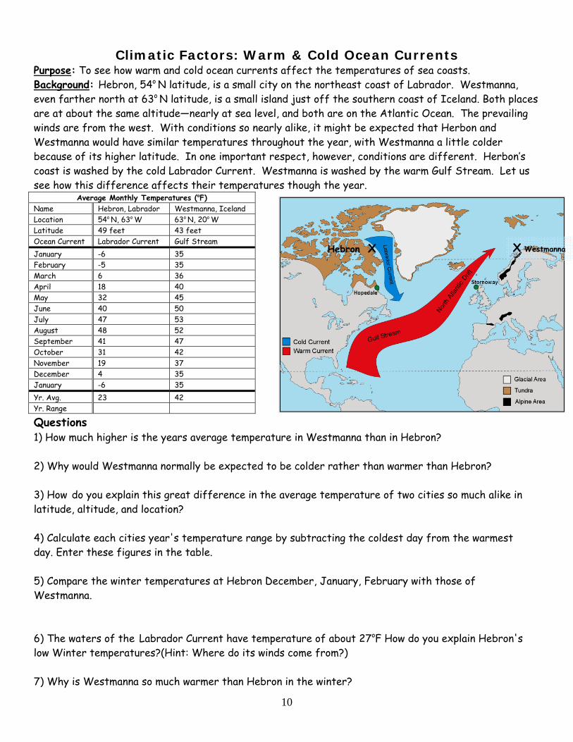
Climatic Factors: Warm & Cold Ocean Currents Purpose: To see how warm and cold ocean currents affect the temperatures of sea coasts. Background: Hebron, 54o N latitude, is a small city on the northeast coast of Labrador. Westmanna, even farther north at 63o N latitude, is a small island just off the southern coast of Iceland. Both places are at about the same altitude—nearly at sea level, and both are on the Atlantic Ocean. The prevailing winds are from the west. With conditions so nearly alike, it might be expected that Herbon and Westmanna would have similar temperatures throughout the year, with Westmanna a little colder because of its higher latitude. In one important respect, however, conditions are different. Herbon’s coast is washed by the cold Labrador Current. Westmanna is washed by the warm Gulf Stream. Let us see how this difference affects their temperatures though the year.
Average Monthly Temperatures (oF) Name Hebron, Labrador Westmanna, Iceland Location 54o N, 63o W 63o N, 20o W Latitude 49 feet 43 feet Ocean Current Labrador Current Gulf Stream January -6 35 February -5 35 March 6 36 April 18 40 May 32 45 June 40 50 July 47 53 August 48 52 September 41 47 October 31 42 November 19 37 December 4 35 January -6 35 Yr. Avg. 23 42 Yr. Range
Questions 1) How much higher is the years average temperature in Westmanna than in Hebron? 2) Why would Westmanna normally be expected to be colder rather than warmer than Hebron? 3) How do you explain this great difference in the average temperature of two cities so much alike in latitude, altitude, and location? 4) Calculate each cities year's temperature range by subtracting the coldest day from the warmest day. Enter these figures in the table. 5) Compare the winter temperatures at Hebron December, January, February with those of Westmanna. 6) The waters of the Labrador Current have temperature of about 27oF How do you explain Hebron's low Winter temperatures?(Hint: Where do its winds come from?) 7) Why is Westmanna so much warmer than Hebron in the winter?
X Westmanna Hebron X
Name: ____________________________ Per: __________
11
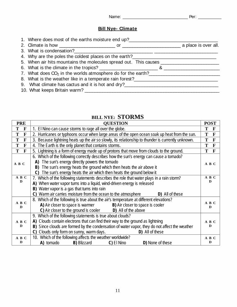
Bill Nye- Climate
1. Where does most of the earths moisture end up?___________________________________ 2. Climate is how ______________________ or _______________________ a place is over all. 3. What is condensation?_______________________________ _________________________ 4. Why are the poles the coldest places on the earth?_________________________________ 5. When air hits mountains the molecules spread out. This causes _______________________ 6. What is the climate in the tropics? _______________________ & ______________________ 7. What does CO2 in the worlds atmosphere do for the earth?____________________________ 8. What is the weather like in a temperate rain forest?_________________________________ 9. What climate has cactus and it is hot and dry?_____________________________________ 10. What keeps Britain warm? _____________________________________________________
BILL NYE: STORMS PRE QUESTION POST T F 1. El Nino can cause storms to rage all over the globe. T F T F 2. Hurricanes or typhoons occur when large areas of the open ocean soak up heat from the sun. T F T F 3. Because lightning heats up the air so slowly, its relationship to thunder is currently unknown. T F T F 4. The Earth is the only planet that contains storms. T F T F 5. Lightning is a form of energy made up of protons that move from clouds to the ground. T F
A B C 6. Which of the following correctly describes how the sun’s energy can cause a tornado?
A) The sun’s energy directly powers the tornado B) The sun’s energy heats the ground which then heats the air above it C) The sun’s energy heats the air which then heats the ground below it
A B C
A B C D 7. Which of the following statements describes the role that water plays in a rain storm?
A) When water vapor turns into a liquid, wind-driven energy is released B) Water vapor is a gas that turns into rain C) Warm air carries moisture from the ocean to the atmosphere D) All of these
A B C D
A B C D
8. Which of the following is true about the air’s temperature at different elevations? A) Air closer to space is warmer B) Air closer to space is cooler C) Air closer to the ground is cooler D) All of the above
A B C D
A B C D
9. Which of the following statements is true about clouds? A) Clouds contain electrons that can find their way to the ground as lightning B) Since clouds are formed by the condensation of water vapor, they do not affect the weather C) Clouds only form on sunny, warm days. D) All of these
A B C D
A B C D
10. Which of the following affects the weather worldwide? A) tornado B) Blizzard C) El Nino D) None of these
A B C D
Name: ____________________________ Per: __________
12
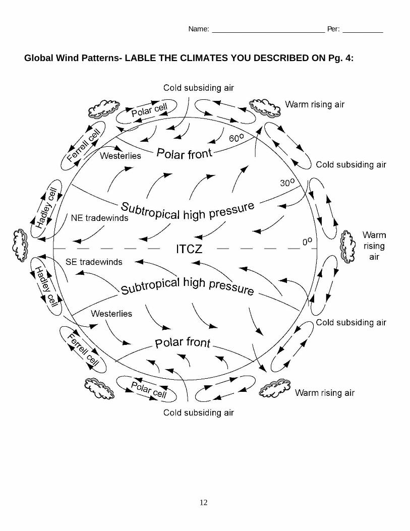
Global Wind Patterns- LABLE THE CLIMATES YOU DESCRIBED ON Pg. 4: