air-deployable profiling floats steven jayne, breck owens and p.e. robbins woods hole oceanographic...
TRANSCRIPT

Air-Deployable Profiling Floats
Steven Jayne, Breck Owens and P.E. RobbinsWoods Hole Oceanographic Institution
Jim Dufour, MRV SystemsElizabeth Sanabia, US Naval Academy
In collaboration with US Air Force Reserve 53rd Weather Reconnaissance Squadron

The TEMPESTS Project
• The Experiment to Measure and Predict East Coast STorm Strength
• Cooperation: WHOI, Gulf of Maine Research Institute, Rutgers Univ., Univ. of Maine, Univ. of Maryland, Univ. Massachusetts Dartmouth & Salisbury Univ.
• Period: September 2013 – August 2016• Instruments: air-deployed floats, gliders and
moorings• Aims: – Observe 2 hurricanes and 2 winter storms– Understand the impacts of vertical
temperaturestratification, storm-induced mixing and sea level changes on storm intensity and inundation
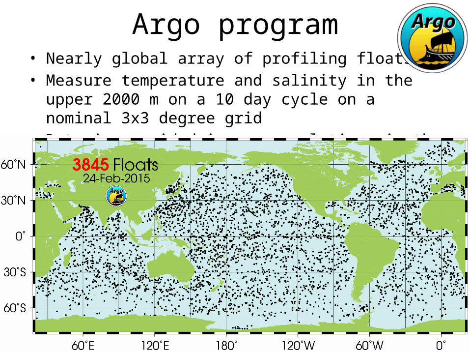
Argo program• Nearly global array of profiling floats• Measure temperature and salinity in the upper
2000 m on a 10 day cycle on a nominal 3x3 degree grid
• Data is provided in near-real time via the GTS and DACs

ALAMOSmaller profiling float that will fit in the AXBT launcher and can be used operationally by the USAF and NOAA Hurricane Hunter planes.
Advantages over AXBT include: multiple profiles, more sensors (pressure, salinity, & accelerometer for surface waves), no VHF receiver equipment on planes
A-sized case
Weight ~10 kg
1200-meter depth rating
1–2 dbar bin-averaged data
Iridium data communication

Deployed through the AXBT launch tube.
Previous air-deployed profiling floats have required opening tail ramp.

A-sized profiling floats were originally developed under funding from ONR, and redeveloped under NOAA Sandy Supplemental funding The ALAMO floats have been tested and deployed in cooperation with USAFR 53rd
WRS

2014 ALAMO deploymentsWMO
numberserial
numberDeployment
DateLocation,
Storm# of
profilesLongevity
(days)
4901722 9038 2014-07-25 Atlantic 387 100
4901723 9035 2014-08-07 Pacific Hurricane Iselle
878 111
4901724 9036 2014-08-07 Pacific Hurricane Iselle
1013 128
4901725 9032 2014-08-18 Gulf of Mexico 268 100
4902037 9031 2014-08-21 AtlanticTS Cristobal
598 150
4902040 9043 2014-09-01 Gulf of Mexico TS Dolly
387 102

2014 Hurricane Season

Float 9035, WMO #4901723Deployed East of Hawaii, Hurricane Iselle
Reported 8 profiles per day from Aug 8 to Nov 25
Profile depth varied from 200 to 300 dbar

4901723 Upper Ocean Temperature

Float 9032, WMO #4901725
NE corner of
Gulf of Mexico
Initially 4 profiles per day then set to once per day
Aug 18 toNov 27

4901725 Upper Ocean Temperature

Sawtooth sampling4 profiles per day to 350 dbar
Sampling strategy:• Rapid sampling vs.
longevity• How often to profile?• What depth?
Daily profile to ~1000 dbardeep drift between profilesConstraints:descent speed: 5–15 cm/sascent speed: 10–30 cm/s
5–15 minutes on surface for GPS & Iridium
More energy to go deep More energy to ascend fast
500 meter profile requires about 4 hours

Gulf of Mexico – Bay of Campeche
Variable sampling strategy:
Initially ~10 profiles per day, set to daily profiles in November
Float 9043, WMO #4902040

ALAMO Data Management & GTS
• Location, profile and engineering data sent by Iridium SBD (Short Burst Data) packets and received by email at WHOI
• WHOI decodes telemetry, updates local database, makes data files and figures
• WHOI FTPs data file to NOAA/AOML in previously defined Argo PHY format. AOML reformats data and submits to GTS
http://argo.whoi.edu/alamo/

ALAMO improvements for 2015
• More robust parachute system for reliable deployment from aircraft at speeds up to 240 knots
• Inductive salinity sensor in addition to temperature & pressure (5 floats)
• Additional features in float firmware:– Better algorithm for descent to park depth– Multiple dive/mission configurations– Accelerometer measurements of surface waves

Discussion
• Where to deploy? (60 floats available)
• How far in advance of a storm• Demonstrate the goal of improving
intensity forecasts• Process studies– Cold wake formation– Recovery: surface fluxes vs. lateral
mixing