agriculture and soils - california energy commission · the agriculture and soils section of this...
TRANSCRIPT
8.8 Agriculture and Soils The agriculture and soils section of this Small Power Plant Exemption (SPPE) Application discusses potential impacts of the proposed Chevron Richmond Refinery Power Plant Replacement Project (PPRP, or the Project) on agricultural lands and soil resources. This section provides an assessment of the significance of impacts during Project construction and operation for the PPRP site (including construction laydown areas) and electric transmission lines.
Section 8.8.2 presents the laws, ordinances, regulations, and standards (LORS) applicable to agriculture and soils. Section 8.8.3 describes the existing environmental setting that could be affected, including agricultural use and soil types. Section 8.8.4 identifies potential environmental effects, if any, from Project development, and Section 8.8.5 presents mitigation measures. Section 8.8.6 describes the required permits and provides agency contacts. Section 8.8.7 provides the references used to develop this section of the SPPE.
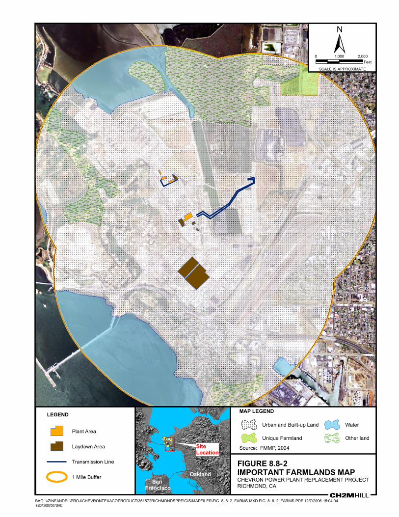
A map of soil types is provided in Figure 8.8-1 (all figures are located at the end of this section). Important farmlands are shown in Figure 8.8-2.
8.8.1 Introduction Chevron is proposing the PPRP to add an additional 60 megawatts (MW) net generation to its existing refinery electrical generation located within Chevron’s Richmond Refinery in the City of Richmond (see Figure 1.2-1) in Contra Costa County, California. The proposed PPRP will be integrated into Chevron’s plans to meet its growing refinery electrical load, and produce steam to replace an existing boiler plant that is approaching its end of life. The PPRP is a subset of the larger Richmond Refinery Renewal Project that is concurrently undergoing California Environmental Quality Act (CEQA) review by the City of Richmond. The California Energy Commission (CEC) has jurisdiction for only the PPRP portion of the Renewal Project that is the subject of this application.
The PPRP will consist of the following components:
• A nominal 43-MW net, natural gas- or liquid petroleum gas (butane)-fired cogeneration train consisting of one combustion turbine generator (CTG), a refinery fuel gas-fired heat recovery steam generator, 13.8-kV switchgear and ancillary equipment.
• Shutdown of the existing No. 1 power plant refinery steam boilers currently providing steam to the Refinery.
• A 17-MW net extraction, condensing steam turbine generator (STG), an associated cooling tower, and 12-kV switchgear installed as part of the new hydrogen production facility (the remainder of the hydrogen plant is under CEQA review as part of the Renewal Project). The new hydrogen plant will be a net generator of steam for both the STG and the refinery steam system.
• Reconductoring of approximately 4,000 feet of existing onsite double-circuit overhead 115-kV transmission line to upgrade its ampacity. The reconductoring will reuse existing transmission line structures.
ES042007007SAC/351572/071630006 (008.8.DOC) 8.8-1
SECTION 8.8: AGRICULTURE AND SOILS
• Adjacent onsite service connections for fuel, reclaimed water, water, wastewater, steam, and electricity to existing piperacks, with the exception of the reconductoring noted above.
The Cogen 3000 portion of the PPRP will occupy approximately 0.5 acre within an existing 5.2-acre cogeneration facility, and the STG and associated equipment (H2-STG) will occupy approximately 0.5 acre within a new 7.9-acre hydrogen plant that will be built as part of the Richmond Refinery Renewal Project. The PPRP will be located well within the heart of the existing 2,900-acre Richmond Refinery. Temporary construction laydown and parking for the PPRP will be provided in various existing laydown areas within the Refinery that are currently used for ongoing maintenance and project laydown. A complete description of the PPRP is provided in Section 2.0.
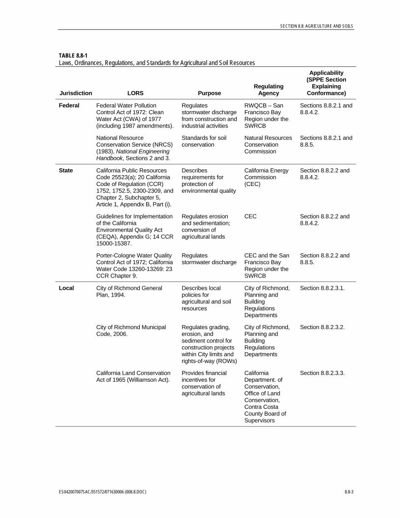
8.8.2 Laws, Ordinances, Regulations and Standards The federal, state, and local LORS that apply to agricultural and soil resources for the Project are discussed below, and are summarized in Table 8.8-1.
8.8.2.1 Federal LORS 8.8.2.1.1 Federal Water Pollution Control Act of 1972 and the Clean Water Act of 1977 The Federal Water Pollution Control Act of 1972, commonly referred to as the Clean Water Act (CWA) following amendment in 1977, establishes requirements for discharges of stormwater or wastewater from any point source that would affect the beneficial uses of waters of the United States. The State Water Resources Control Board (SWRCB) adopted one statewide National Pollutant Discharge Elimination System (NPDES) General Permit that would apply to stormwater discharges associated with construction, industrial, and municipal activities. The San Francisco Bay Regional Water Quality Control Board is the administering agency for the NPDES permit program. The CWA’s primary effect on agriculture and soils within the Richmond Refinery consists of control of soil erosion and sedimentation during construction. This includes the preparation and execution of erosion and sedimentation control plans, and measures for any soil disturbance during construction.
8.8.2.1.2 U.S. Department of Agriculture Engineering Standards The U.S. Department of Agriculture, Natural Resources Conservation Service’s (NRCS’s) National Engineering Handbook (NRCS, 1983), Sections 2 and 3 provide standards for soil conservation during planning, design, and construction. Activities associated with the proposed Project will conform to applicable standards in the National Engineering Handbook to ensure that the Project will not cause soil loss through accelerated erosion.
8.8.2.2 State LORS 8.8.2.2.1 California Public Resources Code Section 25523(a); Title 20 CCR Sections 1752,
1752.5, 2300-2309, and Chapter 2, Subchapter 5, Article 1, Appendix B, Part (i) These regulations stipulate the environmental review and siting procedures to be followed in the development of power generation projects larger than 50 megawatts. The CEC is the administering agency for this authority.
8.8-2 ES042007007SAC/351572/071630006 (008.8.DOC)
SECTION 8.8: AGRICULTURE AND SOILS
TABLE 8.8-1 Laws, Ordinances, Regulations, and Standards for Agricultural and Soil Resources
Jurisdiction LORS Purpose Regulating
Agency
Applicability (SPPE Section
Explaining Conformance)
Federal Federal Water Pollution Control Act of 1972: Clean Water Act (CWA) of 1977 (including 1987 amendments).
Regulates stormwater discharge from construction and industrial activities
RWQCB – San Francisco Bay Region under the SWRCB
Sections 8.8.2.1 and 8.8.4.2.
National Resource Conservation Service (NRCS) (1983), National Engineering Handbook, Sections 2 and 3.
Standards for soil conservation
Natural Resources Conservation Commission
Sections 8.8.2.1 and 8.8.5.
State California Public Resources Code 25523(a); 20 California Code of Regulation (CCR) 1752, 1752.5, 2300-2309, and Chapter 2, Subchapter 5, Article 1, Appendix B, Part (i).
Describes requirements for protection of environmental quality
California Energy Commission (CEC)
Section 8.8.2.2 and 8.8.4.2.
Guidelines for Implementation of the California Environmental Quality Act (CEQA), Appendix G; 14 CCR 15000-15387.
Regulates erosion and sedimentation; conversion of agricultural lands
CEC Section 8.8.2.2 and 8.8.4.2.
Porter-Cologne Water Quality Control Act of 1972; California Water Code 13260-13269: 23 CCR Chapter 9.
Regulates stormwater discharge
CEC and the San Francisco Bay Region under the SWRCB
Section 8.8.2.2 and 8.8.5.
Local City of Richmond General Plan, 1994.
Describes local policies for agricultural and soil resources
City of Richmond, Planning and Building Regulations Departments
Section 8.8.2.3.1.
City of Richmond Municipal Code, 2006.
Regulates grading, erosion, and sediment control for construction projects within City limits and rights-of-way (ROWs)
City of Richmond, Planning and Building Regulations Departments
Section 8.8.2.3.2.
California Land Conservation Act of 1965 (Williamson Act).
Provides financial incentives for conservation of agricultural lands
California Department. of Conservation, Office of Land Conservation, Contra Costa County Board of Supervisors
Section 8.8.2.3.3.
ES042007007SAC/351572/071630006 (008.8.DOC) 8.8-3

SECTION 8.8: AGRICULTURE AND SOILS
8.8.2.2.2 Guidelines for Implementation of CEQA of 1970, 14 CCR, Sections 15000-15387, Appendix G
The CEQA authority must be considered for agriculture and soils for the PPRP because the Project could potentially affect the environment by causing excessive erosion or sedimentation, or impair the agricultural productivity of prime or unique farmlands, or farmlands of statewide importance.
8.8.2.2.3 California Porter-Cologne Water Quality Control Act of 1972; California Water Code, Sections 13260-13269; 23 CFR Chapter 9
The California Water Code requires protection of water quality by appropriate design, sizing, and construction of erosion and sediment controls. The discharge of soil into surface waters resulting from land disturbance may require filing a report of waste discharge (see Water Code Section 13260a).
8.8.2.3 Local LORS The proposed Project is located entirely within the Chevron Richmond Refinery boundaries and does not affect lands in other portions of the City of Richmond or in unincorporated portions of Contra Costa County. As such, regulations associated with Contra Costa County authorities do not directly bear upon the Project.
8.8.2.3.1 City of Richmond General Plan, 1994 The City of Richmond General Plan (City of Richmond, 1994) presents policies within the Open Space and Conservation Element that provide for guidance and implementation of land use controls in and around the City’s sphere of influence. Included in the general plan are provisions for protecting and maintaining open space land uses, which include agricultural uses such as nurseries and grazing lands. The primary impact on soils and agriculture from future development would be the loss of productive farmland.
The Open Space and Conservation Element also describes the City’s policies towards minimizing soil erosion and sedimentation by requiring grading permits, and by having minimum standards for soil erosion and sedimentation control measures (City of Richmond, 1994).
The General Plan has other sections that address agricultural land uses. The identification of agricultural lands (especially those associated with specified preservation areas) is required within the Land Use Element (City of Richmond, 1994).
8.8.2.3.2 City of Richmond Municipal Code The City of Richmond has established a permitting process to evaluate grading and excavation plans for proposed projects. The municipal code for the grading permit review process (City of Richmond Municipal Code Chapter 12.44) establishes permitting requirements and exemptions for general earthwork operations. Additionally, sediment transport and activities that could result in erosion that could cause the discharge of pollutants into stormwater systems or watercourses are regulated under Chapter 12.22 of the City of Richmond Municipal Code.
Prior to construction of the proposed Project, a construction stormwater pollution prevention plan (SWPPP) will be prepared. The SWPPP and an accompanying general stormwater NPDES permit application is submitted to the City’s Engineering Division for
8.8-4 ES042007007SAC/351572/071630006 (008.8.DOC)
SECTION 8.8: AGRICULTURE AND SOILS
initial review and then the SWPPP and permit application is transmitted by the City to the San Francisco Bay Regional Water Quality Control Board (Davidson, pers. comm. 2006).
A grading permit will also be required for excavation and grading activities associated with the Project. The grading permit is secured through the Building Regulations Department and the associated permit fee is based upon a sliding scale depending on the estimated volume of soil that will be affected (Gandhi, pers. comm., 2006).
The site location and design information will be reviewed by the City of Richmond Planning Department (Velasco, pers. comm. 2006). Because the Project will not extend into public rights-of-way beyond the boundaries of the Chevron Richmond Refinery, no encroachment permit will be required.
8.8.2.3.3 California Land Conservation Act of 1965 The California Land Conservation Act of 1965, commonly referred to as the Williamson Act, enables local governments to enter into contracts with private landowners for the purpose of restricting specific parcels of land to agricultural or related open space uses. A landowner can decide that he will not convert a certain parcel of land out of agricultural use for a 10-year period (with an annual review of the land use status). In return, the land is taxed at a rate based on the actual use of the land for agricultural purposes, as opposed to its unrestricted market value. Participation in the Williamson Act program is dependent on County adoption and implementation of the program, and is voluntary for landowners.
8.8.3 Environmental Setting The Project is entirely within the 2,900-acre Chevron Richmond Refinery, which is located in the City of Richmond. The City is located in the western portion of Contra Costa County, California. The Refinery is located along the western edge of the City of Richmond and occupies the majority of the Point San Pablo Peninsula adjacent to the San Pablo Bay. The eastern and southern boundaries of the Refinery are located in the vicinities of residential communities within North Richmond and Point Richmond, respectively. The Chevron Richmond Refinery began operations in 1902 and has been in continuous operation since that time. Zoning for the area is Heavy Industrial land uses (City of Richmond, 1994).
The proposed Project will primarily consist of a combustion turbine with a heat recovery steam cogeneration system and a small cooling tower that provides cooling water for the cogeneration unit.
A new steam turbine generator associated with a new hydrogen plant will also be installed (Note: the new hydrogen plant is undergoing CEQA review by the City under a separate project). The STG also requires the installation and operation of a cooling tower that supplies cooling water to the STG.
Appurtenances associated with the proposed Project include pipeline connections for fuel lines to the cogeneration unit, process water, steam, and wastewater pipelines for both the cogeneration unit and hydrogen plant STG, as well as a new electrical interconnections for hydrogen plant STG and reconductoring of the existing cogeneration 115-kV transmission lines. All proposed facilities will be located within the existing Chevron Richmond Refinery boundaries.
ES042007007SAC/351572/071630006 (008.8.DOC) 8.8-5

SECTION 8.8: AGRICULTURE AND SOILS
Soil resource information for the Project site and vicinity was derived from published soil surveys prepared by the NRCS for Contra Costa County, California (NRCS, 1977), as shown on Figure 8.8-1. Detailed soil descriptions were developed from the soil survey (NRCS, 1977) and from the NRCS Official Series Descriptions (OSD) web page (http://soils.usda.gov/technical/classification/osd/index.html), as summarized in Table 8.8-2. Relevant soil characteristics in the Project area include depth, texture, drainage, permeability, erosion hazard rating, land capability classification, and Storie Index Ratings (used as an indicator of its revegetation potential). The important farmlands designation of the soil mapping unit is also included, where applicable.
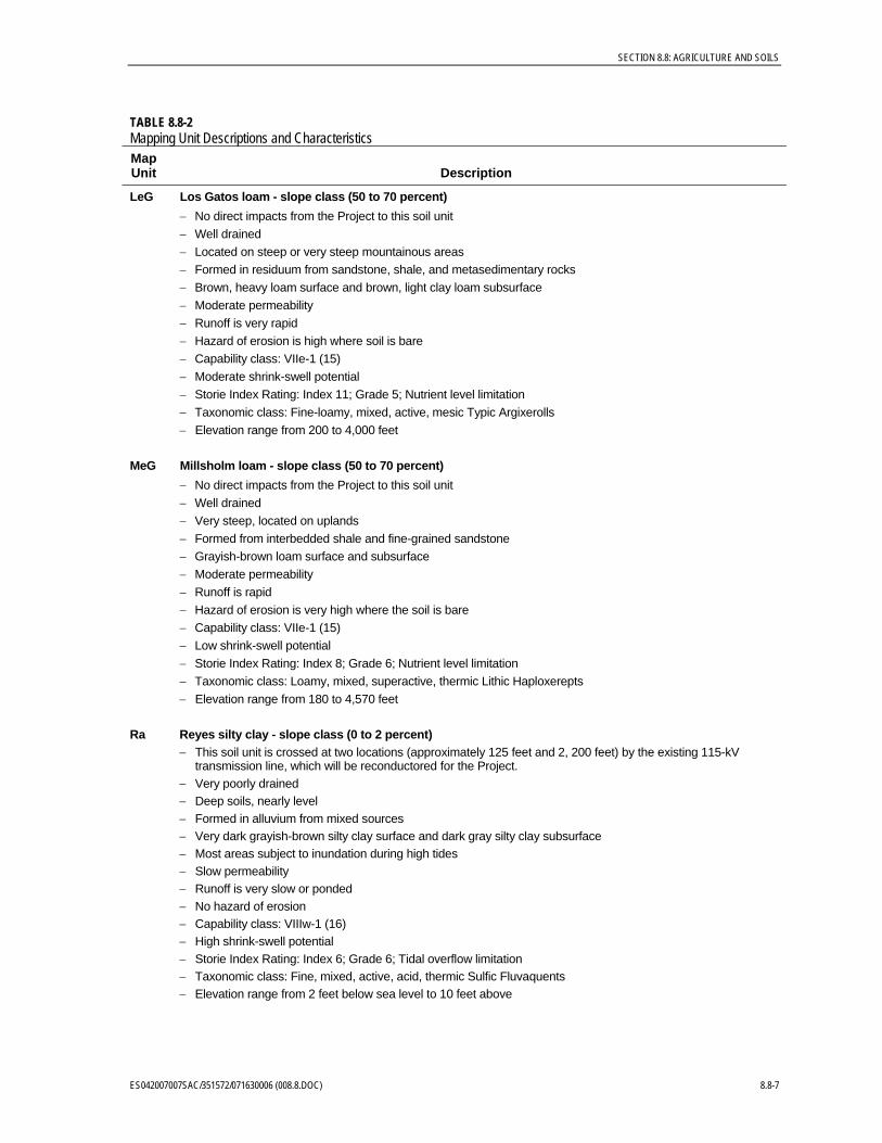
TABLE 8.8-2 Mapping Unit Descriptions and Characteristics Map Unit Description
Cc Clear Lake clay - slope class (0 to 2 percent) − No direct impacts from the Project to this soil unit − Prime Farmland − Poorly drained − Very deep soils, nearly level to gently sloping relief − Formed in alluvium mainly derived from sedimentary rocks − Very dark-gray clay surface and mottled very dark grayish-brown and grayish-brown clay subsurface − Slow to very slow permeability − Runoff is very slow − No hazard of erosion where soil is tilled and exposed − Capability Class: IIs-5 (17) − High shrink-swell potential − Storie Index Rating: Index 49; Grade 3, Drainage limitation − Taxonomic class: Fine, smectitic, therrmic, Xeric Endoaquerts − Elevation range from 25 to 2,000 feet
CeB Conejo clay loam - slope class (2 to 5 percent − Approximately 205 feet of 115-kV transmission line runs through this soil unit. It is expected that two of the
existing electrical towers are located within this unit. − Prime Farmland − Well drained − Very deep soils, gently sloping − Formed in alluvium from basic igneous or sedimentary rocks − Dark-gray clay loam surface and mottled, grayish-brown and brown clay loam subsurface − Moderately slow permeability − Runoff is slow − Hazard of erosion is slight where soil is tilled and exposed − Capability Class: IIe-1 (17) − Moderate shrink-swell potential − Storie Index Rating: Index 81; Grade 1 − Taxonomic class: Fine-loamy, mixed, superactive, thermic Pachic Haploxerolls − Elevation range from 30 to 2,000 feet
8.8-6 ES042007007SAC/351572/071630006 (008.8.DOC)
SECTION 8.8: AGRICULTURE AND SOILS
TABLE 8.8-2 Mapping Unit Descriptions and Characteristics Map Unit Description
LeG Los Gatos loam - slope class (50 to 70 percent) − No direct impacts from the Project to this soil unit − Well drained − Located on steep or very steep mountainous areas − Formed in residuum from sandstone, shale, and metasedimentary rocks − Brown, heavy loam surface and brown, light clay loam subsurface − Moderate permeability − Runoff is very rapid − Hazard of erosion is high where soil is bare − Capability class: VIIe-1 (15) − Moderate shrink-swell potential − Storie Index Rating: Index 11; Grade 5; Nutrient level limitation − Taxonomic class: Fine-loamy, mixed, active, mesic Typic Argixerolls − Elevation range from 200 to 4,000 feet
MeG Millsholm loam - slope class (50 to 70 percent) − No direct impacts from the Project to this soil unit − Well drained − Very steep, located on uplands − Formed from interbedded shale and fine-grained sandstone − Grayish-brown loam surface and subsurface − Moderate permeability − Runoff is rapid − Hazard of erosion is very high where the soil is bare − Capability class: VIIe-1 (15) − Low shrink-swell potential − Storie Index Rating: Index 8; Grade 6; Nutrient level limitation − Taxonomic class: Loamy, mixed, superactive, thermic Lithic Haploxerepts − Elevation range from 180 to 4,570 feet
Ra Reyes silty clay - slope class (0 to 2 percent) − This soil unit is crossed at two locations (approximately 125 feet and 2, 200 feet) by the existing 115-kV
transmission line, which will be reconductored for the Project. − Very poorly drained − Deep soils, nearly level − Formed in alluvium from mixed sources − Very dark grayish-brown silty clay surface and dark gray silty clay subsurface − Most areas subject to inundation during high tides − Slow permeability − Runoff is very slow or ponded − No hazard of erosion − Capability class: VIIIw-1 (16) − High shrink-swell potential − Storie Index Rating: Index 6; Grade 6; Tidal overflow limitation − Taxonomic class: Fine, mixed, active, acid, thermic Sulfic Fluvaquents − Elevation range from 2 feet below sea level to 10 feet above
ES042007007SAC/351572/071630006 (008.8.DOC) 8.8-7
SECTION 8.8: AGRICULTURE AND SOILS
TABLE 8.8-2 Mapping Unit Descriptions and Characteristics Map Unit Description
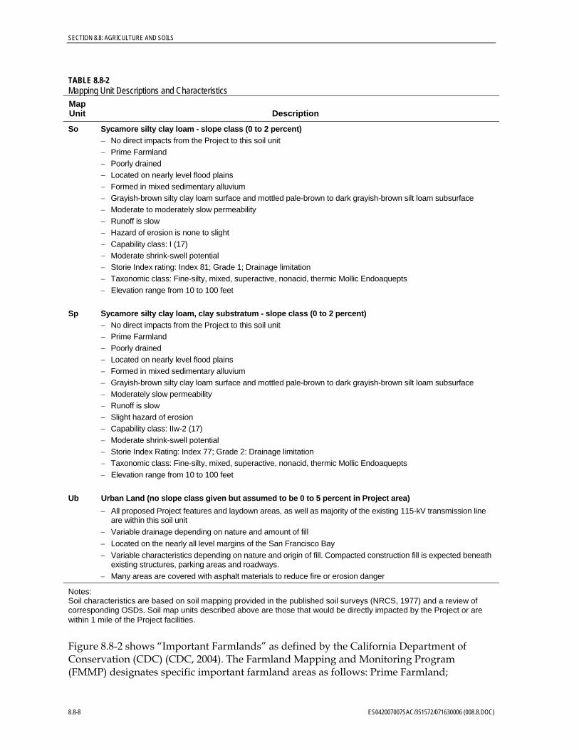
So Sycamore silty clay loam - slope class (0 to 2 percent) − No direct impacts from the Project to this soil unit − Prime Farmland − Poorly drained − Located on nearly level flood plains − Formed in mixed sedimentary alluvium − Grayish-brown silty clay loam surface and mottled pale-brown to dark grayish-brown silt loam subsurface − Moderate to moderately slow permeability − Runoff is slow − Hazard of erosion is none to slight − Capability class: I (17) − Moderate shrink-swell potential − Storie Index rating: Index 81; Grade 1; Drainage limitation − Taxonomic class: Fine-silty, mixed, superactive, nonacid, thermic Mollic Endoaquepts − Elevation range from 10 to 100 feet
Sp Sycamore silty clay loam, clay substratum - slope class (0 to 2 percent) − No direct impacts from the Project to this soil unit − Prime Farmland − Poorly drained − Located on nearly level flood plains − Formed in mixed sedimentary alluvium − Grayish-brown silty clay loam surface and mottled pale-brown to dark grayish-brown silt loam subsurface − Moderately slow permeability − Runoff is slow − Slight hazard of erosion − Capability class: IIw-2 (17) − Moderate shrink-swell potential − Storie Index Rating: Index 77; Grade 2: Drainage limitation − Taxonomic class: Fine-silty, mixed, superactive, nonacid, thermic Mollic Endoaquepts − Elevation range from 10 to 100 feet
Ub Urban Land (no slope class given but assumed to be 0 to 5 percent in Project area) − All proposed Project features and laydown areas, as well as majority of the existing 115-kV transmission line
are within this soil unit − Variable drainage depending on nature and amount of fill − Located on the nearly all level margins of the San Francisco Bay − Variable characteristics depending on nature and origin of fill. Compacted construction fill is expected beneath
existing structures, parking areas and roadways. − Many areas are covered with asphalt materials to reduce fire or erosion danger
Notes: Soil characteristics are based on soil mapping provided in the published soil surveys (NRCS, 1977) and a review of corresponding OSDs. Soil map units described above are those that would be directly impacted by the Project or are within 1 mile of the Project facilities.
Figure 8.8-2 shows “Important Farmlands” as defined by the California Department of Conservation (CDC) (CDC, 2004). The Farmland Mapping and Monitoring Program (FMMP) designates specific important farmland areas as follows: Prime Farmland;
8.8-8 ES042007007SAC/351572/071630006 (008.8.DOC)
SECTION 8.8: AGRICULTURE AND SOILS
Farmland of Statewide Importance; Unique Farmland; and Farmlands of Local Importance. Other land use designations in the FMMP system include Grazing Land; Urban and Built-Up Land; Other Land; and Water.
8.8.3.1 Agricultural Use Figure 8.8-2 shows that the Project facilities are located primarily in an area that is designated as Urban and Built-up Land. Aerial photographs indicate that there is an inundated area that is crossed by the existing 115-kV transmission line that will be reconductored due to this Project. This inundated area is an aerated lagoon operated by the Refinery, indicated on Figure 8.8-1 (shown as water) or Figure 8.8-2 (shown as Urban and Built-up Land). The only mapped important farmland property in proximity to the Project site is a small parcel of land approximately 0.8 mile to the northeast. This agricultural property is designated as Unique Farmland and will not be impacted by the proposed Project.
The Project site is located in an area that is not used for agricultural purposes and is zoned for heavy industrial activities. The majority of the Project features will be constructed within Urban and Built-Up Land areas. For these reasons, construction of the Project will not affect agricultural resources or any land that is currently under a Williamson Act contract.
8.8.3.2 Soil Types As previously described, the soil mapping unit that would be primarily affected by the proposed Project is the Urban Land soil unit. As shown in Figure 8.8-1, two other soil units that may be impacted by the reconductoring of the existing 115-kV transmission lines include the [CeB] Conejo clay loam (2 to 5 percent slopes) and the [Ra] Reyes silty clay. The Conejo clay loam may be affected by over approximately 205 feet during the reconductoring of the existing 115-kV transmission line where the line passes through this soil unit. There are no apparent limitations of this soil unit with respect to construction and the erosion potential is slight.
The Reyes silty clay soil unit is found along the existing 115-kV transmission line. While this soil unit does not have any erosion hazard, it does exhibit high shrink/swell characteristics. However, since no ground-disturbing activities are associated with the transmission line reconductoring, the high shrink/swell characteristics will not affect the Project.
No other soil units mapped in the Project area would be impacted by the proposed Project activities.
8.8.3.3 Prime Farmlands Important Farmlands in the Project vicinity are shown on Figure 8.8-2 (CDC, 2004) and are also summarized in Table 8.8-2. According to this information, there are no Prime Farmlands within 1 mile of the Project.
8.8.3.4 Soil Loss and Erosion Soil loss and erosion in the Project area is expected to be negligible or slight. The majority of the Project site is within the Urban Land soil unit. Fill soils associated with existing or former structures, parking areas, and roadways are likely to consist of compacted
ES042007007SAC/351572/071630006 (008.8.DOC) 8.8-9
SECTION 8.8: AGRICULTURE AND SOILS
construction fill. Given the flat topography in the Project area, and that construction best management practices (BMPs) will be employed, the risk of erosion from these areas is considered negligible. Similarly, the other two soil units that would be affected by reconductoring of the existing 115-kV transmission line facilities, [CeB] Conejo clay loam (2 to 5 percent slopes) and the [Ra] Reyes silty clay, have slight or non-existent erosion hazards. Use of construction BMPs in these areas is expected to effectively control soil losses during construction that could impact air or surface water resources.
8.8.4 Impacts 8.8.4.1 Environmental Checklist Table 8.8-3 provides the CEQA Checklist questions that are used in this SPPE Application to assess the significance of potential impacts.
TABLE 8.8-3 CEQA Checklist
Impacts
Potentially Significant
Impact
Less than Significant with
Mitigation
Less than Significant
Impact No
Impact
SOILS—Would the Project:
Convert to non-agricultural use the Prime Farmland, Unique Farmland, or Farmland of Statewide Importance, as shown on the maps for the FMMP by the California Resources Agency?
X
Conflict with existing zoning for agricultural use or a Williamson Act contract?
X
Involve other changes in the existing environment which, due to their location or nature, could result in conversion of Prime Farmland, Unique Farmland, or Farmland of Statewide Importance to non-agricultural use?
X
Impact jurisdictional wetlands? X
Result in substantial soil erosion? X
Be located on expansive soil, as defined in Table 18-1-B of the Uniform Building Code (1994), creating substantial risks to life or property?
X
Have soils incapable of adequately supporting the use of septic tanks or alternative wastewater disposal systems where sewers are not available for the disposal of wastewater?
X
8.8.4.2 Discussion of Impacts The following information is intended to allow assessment of impacts associated with the specific proposed Project activities.
8.8-10 ES042007007SAC/351572/071630006 (008.8.DOC)
SECTION 8.8: AGRICULTURE AND SOILS
8.8.4.2.1 Buildings and Laydown Areas The majority of the Project facilities are located on the Urban Land soil unit. As previously described, the soil survey does not provide specific descriptions of soil characteristics for these areas. This is because these conditions are a function of the type and amount of fill materials that have been imported to create the current landscape. It is expected, however, that in locations where previous Chevron Richmond Refinery facilities (for example, buildings, parking areas, and roadways) have been constructed, the fill will consist of compacted construction material. It is further expected that impacts to these soils from construction and operation of the proposed Project facilities will be negligible.
8.8.4.2.2 Transmission Lines As previously described, the reconductoring of the existing transmission line would occur on the Urban Land soil unit and the [CeB] Conejo clay loam (2 to 5 percent slopes) and the [Ra] Reyes silty clay soil units. Since the reconductoring would not result in ground disturbance, impacts to these two soil units are not expected.
Changes in the physical characteristics of the soil will occur due to mechanical compaction required to provide suitable foundation support for the structures associated with the proposed facilities and transmission lines. Mechanical compaction will increase the in situ density of the soil, and reduce its porosity and permeability. The majority of existing area around the Project site is already paved or will be paved after completion of the Project. In areas that have existing or former facilities, it is expected that these soils will already have been compacted prior to previous construction activities. Any areas that are not paved after construction of the Project will be covered with gravel. This activity will reduce surface infiltration of the site and increase surface runoff. The additional surface water runoff will be directed via catchment basins and underground culverts to the Refinery’s existing stormwater system.
The Chevron Richmond Refinery has not been used for agricultural purposes for the past 100 years. Furthermore, there is only a limited, mapped area of farmland within 1 mile of the proposed facilities (see Figure 8.8-2). There are no Prime Farmlands mapped within 1 mile of the proposed Project facilities. For these reasons, the Project will not result in any conversion of “Farmlands” to non-agricultural use. The mapped soil units that would be affected by the construction of the Project facilities indicate a negligible or slight potential for soil loss from water erosion. Given the planned use of construction BMPs, actual soil losses from water or wind are expected to be negligible. The proposed Project will tie into existing sanitary wastewater facilities so onsite septic systems will not be required.
Environmental investigations were conducted on the Chevron Richmond Refinery site for subsurface soils beneath the proposed hydrogen plant site and the cogeneration plant site (SAIC, 2006a; 2006b). These studies indicated that samples of these media had been impacted with constituents of potential concern (COPCs) associated with historical industrial activities such as total petroleum hydrocarbons (TPH) in the gasoline and diesel ranges and metals (mercury and lead). These studies indicated that some of the soils at both facilities exceeded federal and/or state criteria for hazardous waste, which will require special handling and prevent the re-use of those soils during construction.
At the proposed hydrogen facility, it was also noted that shallow groundwater (1 to 4 feet below ground surface) had free-phase liquid hydrocarbon at nearly half of the 63 sample
ES042007007SAC/351572/071630006 (008.8.DOC) 8.8-11
SECTION 8.8: AGRICULTURE AND SOILS
locations that were investigated and had several groundwater samples among five locations where the maximum allowable contaminant limits (MACLs) established for the Refinery were exceeded (SAIC, 2006a). The results of these investigations indicate that plans will have to be developed to protect future construction and site workers from exposures to COPCs and to properly handle affected environmental media (i.e., soil and groundwater).
8.8.4.2.3 Operational Impacts The Project operation will not result in impacts to the soil from erosion or compaction. Routine vehicle traffic during Project operation will be limited to existing roads, most of which will be paved or covered with gravel. Standard operating activities will not routinely involve the disruption of soil. Anticipated impacts to soil resources from Project operations will be less-than-significant.
8.8.4.2.4 Effects of Generating Facility Emissions on Soil-Vegetation Systems There is a concern in some areas that emissions from the generating facility, principally nitrogen oxides (NOx) from the combustors or drift from the cooling towers, would have an adverse effect on soil-vegetation systems in the Project vicinity. This is principally a concern where environments that are highly sensitive to nutrients or salts, such as serpentine habitats, are downwind of the Project.
In this case, the dominant land use around the Project is urban and the serpentine habitats in the Project area are all developed for industrial, commercial, or residential uses. The addition of small amounts of nitrogen to the industrial and commercial areas would be insignificant because of the paucity of vegetation in these areas. Within the more vegetated residential areas, the addition of small amounts of nitrogen would be insignificant within the context of fertilizers, herbicides, and pesticides typically used by homeowners. It should also be noted that the proposed cogeneration unit is designed to control NOx emissions. For these reasons, the operations of the cogeneration unit is not expected to have any effect on soil or agricultural resources in the Project vicinity.
8.8.4.3 Summary of Impacts There are no lands currently used for agricultural purposes that would be affected by the proposed Project or transmission line. The proposed Project features all occur within the Chevron Richmond Refinery Facility limits in an area currently zoned for heavy industrial use. No impacts to agricultural resources will occur due to construction or operations of the Project facilities.
Use of BMPs during construction will reduce the potential for soil erosion to a less-than-significant level. Pavement or gravel covering exposed portions of the Refinery site will reduce the potential for soil erosion after Project completion to a less-than-significant level. Emissions of NOx during the Project operations are expected to have a less-than-significant impact.
8.8.4.4 Cumulative Impacts The current City of Richmond General Plan (1994) designates the proposed Project site and vicinity for current and future heavy industrial purposes, which is consistent with the proposed Project. Because the Project will not affect any agricultural resources, and will have limited impacts in already disturbed industrial areas, the Project is not expected to have any cumulative impacts to agricultural or soil resources in Contra Costa County.
8.8-12 ES042007007SAC/351572/071630006 (008.8.DOC)

SECTION 8.8: AGRICULTURE AND SOILS
8.8.5 Mitigation Measures Erosion control measures would be required during construction to help maintain water quality, protect property from erosion damage, and prevent accelerated soil erosion or dust generation that destroys soil productivity and soil capacity. Temporary erosion control measures could be installed before construction begins, would be maintained and evaluated during construction, and would be removed from the site after the completion of construction.
8.8.5.1 Temporary Erosion Control Measures Temporary erosion control measures would be implemented before construction begins, and would be evaluated and maintained during construction. These measures typically include physical stabilization, dust suppression, berms, ditches, and sediment barriers. Disturbed areas would be paved or covered with gravel as soon as possible after construction.
During construction of the Project and the related linear facilities, dust erosion control measures would be implemented to minimize the wind-blown erosion of soil from the site. Water of a quality equal to or better than either existing surface runoff or irrigation water would be sprayed on the soil in construction areas to control dust.
Because of the potential for contaminated soil and groundwater beneath proposed Project structures, it will be necessary to develop plans to protect future construction and site workers from exposures to COPCs and to properly handle affected environmental media.
Sediment barriers, such as straw bales, sand bags, or silt fences, will slow runoff and trap sediment. Sediment barriers are generally placed below disturbed areas, at the base of exposed slopes, and along streets and property lines below the disturbed area. Sediment barriers are often placed around sensitive areas, such as creeks or storm drains, to prevent contamination by sediment-laden water.
The site will be constructed on relatively level ground; therefore, it is not considered necessary to place barriers around the property boundary. Some barriers, however, would be placed in locations where offsite drainage could occur to prevent sediment from leaving the site. Barriers and other sedimentation control measures would be used to prevent runoff into irrigation ditches or water bodies located near the site. If used, straw bales would be properly installed (staked and keyed), then removed or used as mulch after construction. Runoff detention basins, drainage diversions, and other large-scale sediment traps are not considered necessary due to the level topography and surrounding paved areas. Any soil stockpiles would be stabilized and covered if left onsite for long periods of time, including placement of sediment barriers around the base of the stockpile.
8.8.5.2 Permanent Erosion Control Measures After construction is complete, all exposed areas are planned to be paved or covered with gravel, representing the permanent erosion control measures for the site.
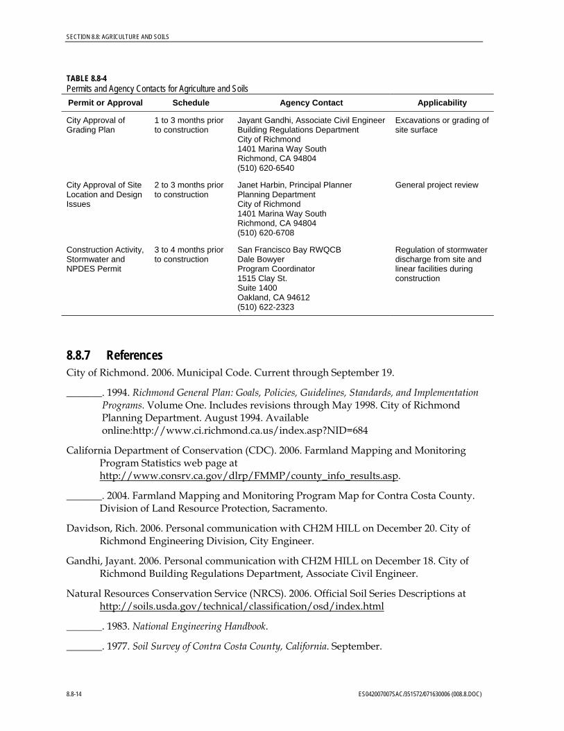
8.8.6 Permits and Agency Contacts Permits required for the Project, the responsible agencies, and proposed schedule are shown in Table 8.8-4.
ES042007007SAC/351572/071630006 (008.8.DOC) 8.8-13
SECTION 8.8: AGRICULTURE AND SOILS
TABLE 8.8-4 Permits and Agency Contacts for Agriculture and Soils
Permit or Approval Schedule Agency Contact Applicability
City Approval of Grading Plan
1 to 3 months prior to construction
Jayant Gandhi, Associate Civil EngineerBuilding Regulations Department City of Richmond 1401 Marina Way South Richmond, CA 94804 (510) 620-6540
Excavations or grading of site surface
City Approval of Site Location and Design Issues
2 to 3 months prior to construction
Janet Harbin, Principal Planner Planning Department City of Richmond 1401 Marina Way South Richmond, CA 94804 (510) 620-6708
General project review
Construction Activity, Stormwater and NPDES Permit
3 to 4 months prior to construction
San Francisco Bay RWQCB Dale Bowyer Program Coordinator 1515 Clay St. Suite 1400 Oakland, CA 94612 (510) 622-2323
Regulation of stormwater discharge from site and linear facilities during construction
8.8.7 References City of Richmond. 2006. Municipal Code. Current through September 19.
_______. 1994. Richmond General Plan: Goals, Policies, Guidelines, Standards, and Implementation Programs. Volume One. Includes revisions through May 1998. City of Richmond Planning Department. August 1994. Available online:http://www.ci.richmond.ca.us/index.asp?NID=684
California Department of Conservation (CDC). 2006. Farmland Mapping and Monitoring Program Statistics web page at http://www.consrv.ca.gov/dlrp/FMMP/county_info_results.asp.
_______. 2004. Farmland Mapping and Monitoring Program Map for Contra Costa County. Division of Land Resource Protection, Sacramento.
Davidson, Rich. 2006. Personal communication with CH2M HILL on December 20. City of Richmond Engineering Division, City Engineer.
Gandhi, Jayant. 2006. Personal communication with CH2M HILL on December 18. City of Richmond Building Regulations Department, Associate Civil Engineer.
Natural Resources Conservation Service (NRCS). 2006. Official Soil Series Descriptions at http://soils.usda.gov/technical/classification/osd/index.html
_______. 1983. National Engineering Handbook.
_______. 1977. Soil Survey of Contra Costa County, California. September.
8.8-14 ES042007007SAC/351572/071630006 (008.8.DOC)

SECTION 8.8: AGRICULTURE AND SOILS
ES042007007SAC/351572/071630006 (008.8.DOC) 8.8-15
Science Applications International Corporation (SAIC). 2006a. Capital Projects: Hydrogen Plant Project Site Soil Pre-Characterization Results. HW Job #: S2996. Chevron Richmond Refinery. April 28.
_______. 2006b. Capital Projects: COGEN Project Site Soil Pre-Characterization Results. HW Job #: S2997. Chevron Richmond Refinery. May 9.
Velasco, Lina. 2006. Personal communication with CH2M HILL on December 20. City of Richmond Planning Department, Planner.

w
w
Ub
Ra
MeG
w
w
Cc
Ra
CeB
Sp
w
Cc
w
LeG
Qa
CeB
Ub
w
So
w
w
Ra
w
DRAFT
BAO \\ZINFANDEL\PROJ\CHEVRONTEXACOPRODUCT\351572RICHMONDSPPE\GIS\MAPFILES\FIG_8_8_1_SOILS.MXD FIG_8_8_1_SOILS.PDF 1/3/2007 14:13:32
FIGURE 8.8-1SOILS MAP
SanFrancisco
Oakland
SiteLocation
SCALE IS APPROXIMATE
0 1,000 2,000Feet
±
SOIL LEGENDCc - Clear Lake clayCeB - Conejo clay loam, 2 to 5 percent slopesLeG - Los Gatos loam, 50 to 70 percent slopesMeG - Millsholm loam, 50 to 70 percent slopesQa - Quarry Ra - Reyes Silty ClaySo - Sycamore silty clay loamSp - Sycamore silty clay loam, clay substratumUb - Urban Land w - WaterSource: NRCS, 1977
LEGEND
Plant
Laydown
Soil Map Unit Boundary
1 Mile Buffer
Transmission Lines
ES042007007SAC figure_8_8_1.ai 06/13/07 tdaus
CHEVRON POWER PLANT REPLACEMENT PROJECTRICHMOND, CA
DRAFT
BAO \\ZINFANDEL\PROJ\CHEVRONTEXACOPRODUCT\351572RICHMONDSPPE\GIS\MAPFILES\FIG_8_8_2_FARMS.MXD FIG_8_8_2_FARMS.PDF 12/7/2006 15:04:04
LEGEND
Plant Area
Laydown Area
Transmission Line
1 Mile Buffer
FIGURE 8.8-2IMPORTANT FARMLANDS MAP
SanFrancisco
Oakland
SiteLocation
SCALE IS APPROXIMATE
0 1,000 2,000Feet
±
MAP LEGEND
Urban and Built-up Land
Unique Farmland
Water
Other land
Source: FMMP, 2004
ES042007007SAC
CHEVRON POWER PLANT REPLACEMENT PROJECTRICHMOND, CA