aermod view - addlink software científico · aermod view™ gaussian plume air dispersion model -...
TRANSCRIPT
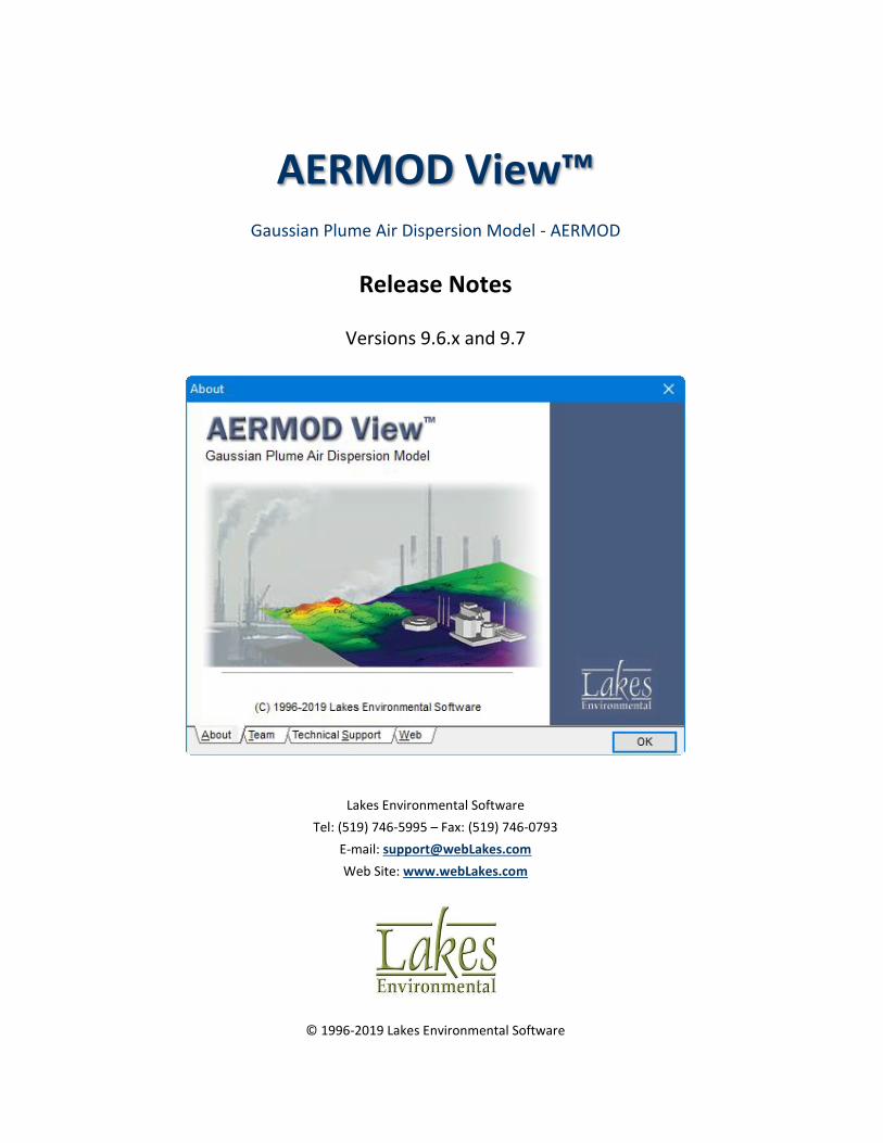
AERMOD View™ Gaussian Plume Air Dispersion Model - AERMOD
Release Notes
Versions 9.6.x and 9.7
Lakes Environmental Software
Tel: (519) 746-5995 – Fax: (519) 746-0793
E-mail: [email protected]
Web Site: www.webLakes.com
© 1996-2019 Lakes Environmental Software

AERMOD View™ Release Notes
2 of 23 Lakes Environmental Software
E-mail: [email protected]
Web: www.webLakes.com
AERMOD View™ Version 9.7
Release Notes
June 17, 2019
New Features
Topic Feature Description
AERMET View New AERSURFACE 19039_DRFT Model & AERSURFACE Utility
On February 21, 2019, the US EPA released the new AERSURFACE 19039_DRFT tool. Updates in the new tool include:
• Support for National Land Cover Database (NLCD) 2001, 2006, & 2011 GeoTIFF-format land cover data files which cover CONUS, Hawaii, Alaska, & Puerto Rico.
• Addition of percent Canopy and percent Impervious data files for years corresponding to the selected land cover data.
• Experimental surface roughness calculation methodology (ZOEFF)
• Separation of airport selection by sector for surface roughness calculations.
• Debug output files for data analysis
AERMET View’s AERSURFACE utility includes support for 19039_DRFT in addition to the existing regulatory version (13016). New features include:
• Preview window with Tile Maps functionality for visually identifying surface roughness sectors
• Automated data downloads via of land cover, canopy, and impervious datasets (see note below)
• Reformatted data inputs in easy-to-use tabs
• Import capabilities for handling existing AERSURACE projects
• Added preview of output files directly to the utility for easy review
NOTE: Download of NLCD data via WebGIS is limited to users with a current maintenance agreement.

AERMOD View™ Release Notes
3 of 23 Lakes Environmental Software
E-mail: [email protected]
Web: www.webLakes.com
Topic Feature Description
AERMET View New AERSURFACE 19039_DRFT Model & AERSURFACE Utility (Continued)

AERMOD View™ Release Notes
4 of 23 Lakes Environmental Software
E-mail: [email protected]
Web: www.webLakes.com
Topic Feature Description
AERMET View QA Statistics Spreadsheet for Surface Met Data File (*.SFC)
A Surface File QA button has been added to the Output Files tab in AERMET View. This generates an Excel spreadsheet with quarterly data analysis of missing and calm hours. The data can be used to satisfy regulatory requirements for documenting data quality.
The file includes counts and percentages of missing hours for met parameters including wind, temperature, cloud cover, humidity, pressure, and precipitation.
AERMOD View™ Release Notes
5 of 23 Lakes Environmental Software
E-mail: [email protected]
Web: www.webLakes.com
Topic Feature Description
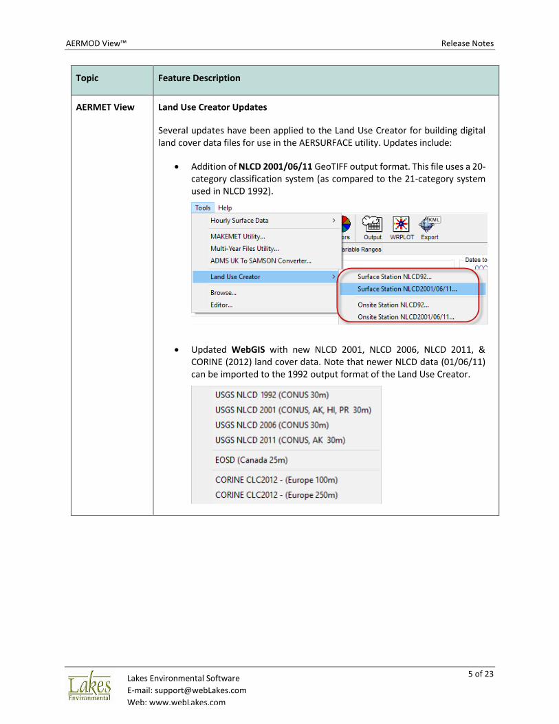
AERMET View Land Use Creator Updates
Several updates have been applied to the Land Use Creator for building digital land cover data files for use in the AERSURFACE utility. Updates include:
• Addition of NLCD 2001/06/11 GeoTIFF output format. This file uses a 20-category classification system (as compared to the 21-category system used in NLCD 1992).
• Updated WebGIS with new NLCD 2001, NLCD 2006, NLCD 2011, & CORINE (2012) land cover data. Note that newer NLCD data (01/06/11) can be imported to the 1992 output format of the Land Use Creator.

AERMOD View™ Release Notes
6 of 23 Lakes Environmental Software
E-mail: [email protected]
Web: www.webLakes.com
Topic Feature Description
AERMET View Addition of NLCD 2001/06/11 Data to Land Use Viewer
The Land Use Viewer now displays output from the new AERSURFACE 19039_DRFT with NLCD 2001/06/11 land cover categories.
Terrain Processor
Support for Non-US GeoTIFF Terrain Data Files
The Terrain Processor is now able to read and process terrain data files in GeoTIFF format for locations outside the United States. This includes the Canadian Digital Elevation Model (CDEM) data.
Support is handled by setting the Horizontal Datum selection to “Unknown” for all non-USGS NED files. This forces AERMAP to read coordinates in the same datum as that identified for the project (View | Map Projection settings).

AERMOD View™ Release Notes
7 of 23 Lakes Environmental Software
E-mail: [email protected]
Web: www.webLakes.com
Topic Feature Description
Receptor Pathway
Multi-Select Tools for Sensitive Receptors
To improve selection of discrete receptors as Sensitive, multi-select tools have been added to the Discrete Cartesian Receptors settings.
Receptor Pathway
Disable Gridded Receptors from Plant Boundary
Gridded receptors can now be disabled directly from within the Plant Boundary dialog. Application of either function will automatically remove all gridded receptor types.
Note: Discrete receptors can be still removed via the Actions | Remove Plant Receptors menu option.
AERMOD View™ Release Notes
8 of 23 Lakes Environmental Software
E-mail: [email protected]
Web: www.webLakes.com
Topic Feature Description
Receptor Pathway
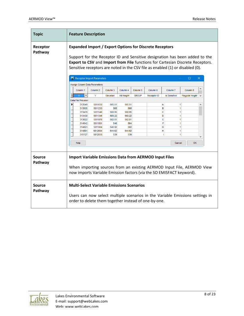
Expanded Import / Export Options for Discrete Receptors
Support for the Receptor ID and Sensitive designation has been added to the Export to CSV and Import from File functions for Cartesian Discrete Receptors. Sensitive receptors are noted in the CSV file as enabled (1) or disabled (0).
Source Pathway
Import Variable Emissions Data from AERMOD Input Files
When importing sources from an existing AERMOD Input File, AERMOD View now imports Variable Emission factors (via the SO EMISFACT keyword).
Source Pathway
Multi-Select Variable Emissions Scenarios
Users can now select multiple scenarios in the Variable Emissions settings in order to delete them together instead of one-by-one.

AERMOD View™ Release Notes
9 of 23 Lakes Environmental Software
E-mail: [email protected]
Web: www.webLakes.com
Topic Feature Description
Source Pathway
Character Limit to Auto-Generated Source Groups
The AERMOD model limits source groups to no more than 8 characters while source IDs can have up to 12 characters. When using the Auto-Generated Source Groups utility, an issue could appear when naming groups by source ID due to the character restriction. AERMOD View now issues a warning in this situation so users can adjust group names accordingly.
Output Pathway
Zero Values Added to Exceedance Count Contour Plot
The contour plot of exceedances generated by AERMOD View after analyzing the Threshold Violation file (MAXIFILE) now includes 0 values at receptors with no exceedances. This produces a smoother contour plot.
Smoothed Exceedance Count Contour Plot

AERMOD View™ Release Notes
10 of 23 Lakes Environmental Software
E-mail: [email protected]
Web: www.webLakes.com
Topic Feature Description
Output Pathway
Auto-Processing Percentiles
When the Percentiles functionality is enabled, AERMOD View will now processing this output automatically before the display of any warning dialogs.
Projects Warnings for Invalid Characters
When starting a new project or saving an existing project, AERMOD View will now warn users who attempt to use invalid characters in the project name. These include apostrophes (‘), quotation marks (“), and percent symbols (%).
Project Status Updated Warnings in Details
The messages presented in Details for projects with warnings and potential errors have been updated to reflect all project data.
AERMOD View™ Release Notes
11 of 23 Lakes Environmental Software
E-mail: [email protected]
Web: www.webLakes.com
Fixed Issues
Topic Issue Description
Import Import Sources from Excel
Fixed an issue where AERMOD View was unable to recognize some XLSX files.
Import Buildings from BPIP Input File
An issue prevented AERMOD View from importing buildings from existing BPIP input files if the building IDs contained spaces. This has been resolved.
Control Pathway
ALPHA Keyword Application
The ALPHA keyword was incorrectly written to the model input file for 18081 model runs when the Non-Default options were enabled and the Adjusted Surface Friction Velocity (ADJ_U*) option selected.
Sources Maintain Existing Source Ranges When Removing Individual Sources
In functions that support specification of source ranges (e.g., Source Groups, PSD Groups, In-Stack NO2/NOx Ratios, etc.), ranges will be preserved after removal of the first or last Source ID within the range. Previously, the entire range was removed from the project setup. Modelers are strongly encouraged to validate source range selections.
Sources Buoyant Line Emission Rate
The emission rate label for Buoyant Line sources was updated in the Source List and Multi-Chem Run utility to show the proper g/s label. This change was to the label only as values were processed as g/s in previous versions.
Source Pathway
Default Urban Groups Option
The default setting for Urban Groups was restored to the “Single Urban Group ( ALL Sources)” setting.
Source Pathway
Hourly Emission File Maker Utility Support for ISC Model
The File Maker utility was updated to fully support ISCST3 & ISC-PRIME projects. The utility now prepares EMI files with two-digit years instead of four-digits and reads meteorological data from the ISC-specific meteorological data file.
AERMOD View™ Release Notes
12 of 23 Lakes Environmental Software
E-mail: [email protected]
Web: www.webLakes.com
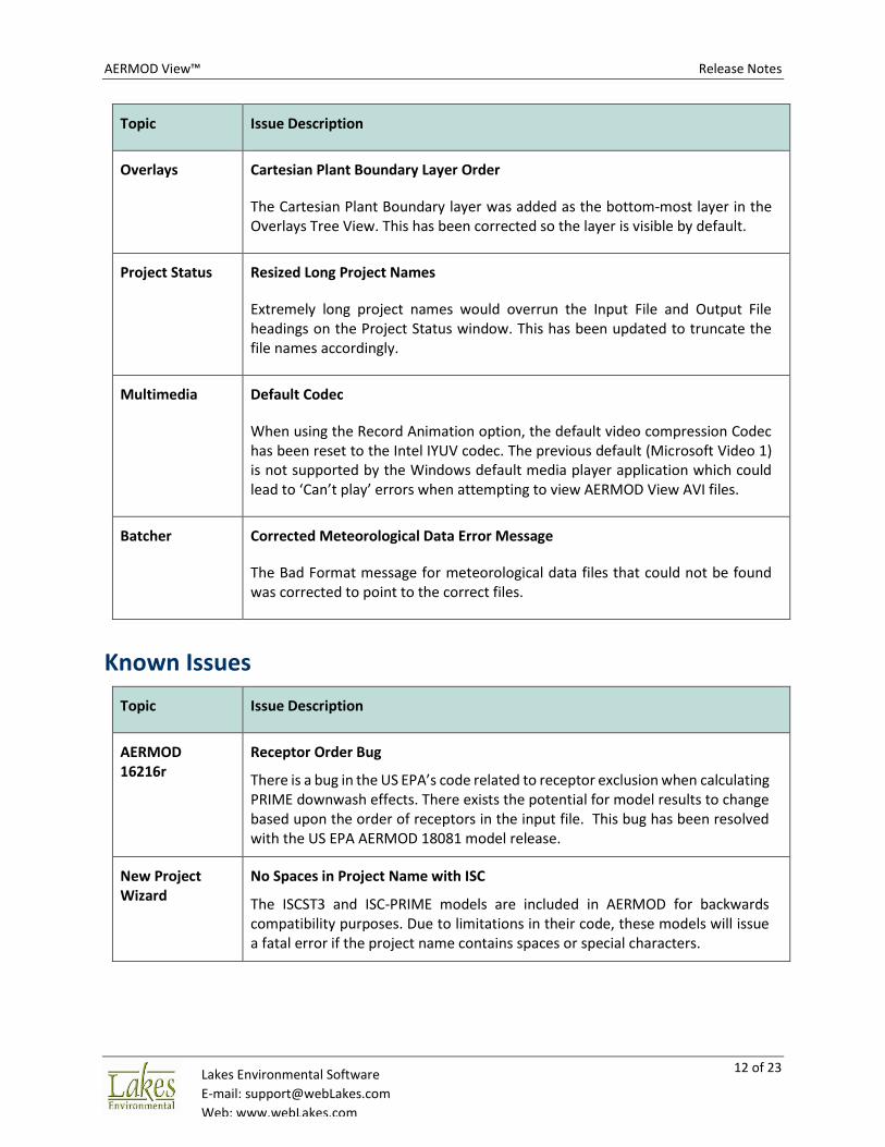
Topic Issue Description
Overlays Cartesian Plant Boundary Layer Order
The Cartesian Plant Boundary layer was added as the bottom-most layer in the Overlays Tree View. This has been corrected so the layer is visible by default.
Project Status Resized Long Project Names
Extremely long project names would overrun the Input File and Output File headings on the Project Status window. This has been updated to truncate the file names accordingly.
Multimedia Default Codec
When using the Record Animation option, the default video compression Codec has been reset to the Intel IYUV codec. The previous default (Microsoft Video 1) is not supported by the Windows default media player application which could lead to ‘Can’t play’ errors when attempting to view AERMOD View AVI files.
Batcher Corrected Meteorological Data Error Message
The Bad Format message for meteorological data files that could not be found was corrected to point to the correct files.
Known Issues
Topic Issue Description
AERMOD 16216r
Receptor Order Bug
There is a bug in the US EPA’s code related to receptor exclusion when calculating PRIME downwash effects. There exists the potential for model results to change based upon the order of receptors in the input file. This bug has been resolved with the US EPA AERMOD 18081 model release.
New Project Wizard
No Spaces in Project Name with ISC
The ISCST3 and ISC-PRIME models are included in AERMOD for backwards compatibility purposes. Due to limitations in their code, these models will issue a fatal error if the project name contains spaces or special characters.

AERMOD View™ Release Notes
13 of 23 Lakes Environmental Software
E-mail: [email protected]
Web: www.webLakes.com
AERMOD View™ Version 9.6.5
Release Notes
September 28, 2018
Fixed Issues
Topic Issue Description
AERMET View Onsite Data Records Limits Increased
To fully support prognostic model (WRF or MM5) output generated by the US EPA MMIF utility, the number of data records per observation period and number of multi-level measurement heights accepted by AERMET View were increased to 50.
AERMET View Project Status Update
Corrected an erroneous message in Project Status that did not recognize an AERSURFACE output file in the Sectors tab without the user first reviewing the tab.
AERMET View Upper Air Estimator
A minor adjustment was made to the code to prevent unexpected shutdown of the Upper Air Estimator in rare cases.
AERMOD View™ Release Notes
14 of 23 Lakes Environmental Software
E-mail: [email protected]
Web: www.webLakes.com
AERMOD View™ Version 9.6
Release Notes
May 30, 2018
New Features
Topic Feature Description
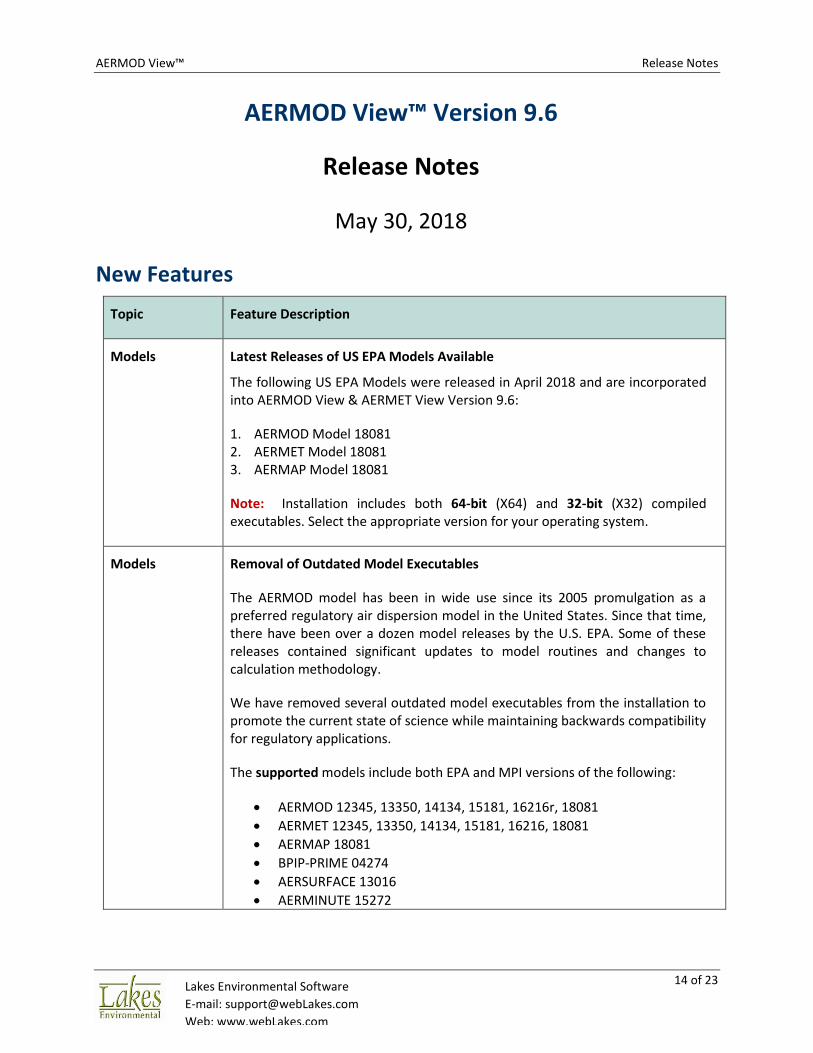
Models Latest Releases of US EPA Models Available
The following US EPA Models were released in April 2018 and are incorporated into AERMOD View & AERMET View Version 9.6:
1. AERMOD Model 18081 2. AERMET Model 18081 3. AERMAP Model 18081
Note: Installation includes both 64-bit (X64) and 32-bit (X32) compiled executables. Select the appropriate version for your operating system.
Models Removal of Outdated Model Executables
The AERMOD model has been in wide use since its 2005 promulgation as a preferred regulatory air dispersion model in the United States. Since that time, there have been over a dozen model releases by the U.S. EPA. Some of these releases contained significant updates to model routines and changes to calculation methodology.
We have removed several outdated model executables from the installation to promote the current state of science while maintaining backwards compatibility for regulatory applications.
The supported models include both EPA and MPI versions of the following:
• AERMOD 12345, 13350, 14134, 15181, 16216r, 18081
• AERMET 12345, 13350, 14134, 15181, 16216, 18081
• AERMAP 18081
• BPIP-PRIME 04274
• AERSURFACE 13016
• AERMINUTE 15272

AERMOD View™ Release Notes
15 of 23 Lakes Environmental Software
E-mail: [email protected]
Web: www.webLakes.com
Topic Feature Description
AERMOD MPI New Version of Lakes AERMOD MPI 18081 (Parallel Version)
A new version of the Lakes AERMOD MPI for the US EPA Model Version 18081 is now available (AERMOD_MPI_Lakes_18081.exe). Install includes 64-bit and 32-bit versions. You can specify to use this model under the Preferences dialog.
Note: AERMOD_MPI_LAKES_18081.EXE or AERMOD_MPI_LAKES.EXE will run the latest version of the AERMOD model (18081) in parallel mode using up to a maximum of 8 cores.
AERMAP MPI New Version of Lakes AERMAP MPI 18081 (Parallel Version)
A new version of the Lakes AERMAP MPI for the US EPA Model Version 18081 is now available (AERMAP_MPI_Lakes_18081.exe). Install includes 64-bit and 32-bit versions. You can specify to use this model under the Preferences dialog.
Note: AERMAP_MPI_LAKES_18081.EXE or AERMAP_MPI_LAKES.EXE will run the latest version of the AERMAP model (18081) in parallel mode using up to a maximum of 8 cores.

AERMOD View™ Release Notes
16 of 23 Lakes Environmental Software
E-mail: [email protected]
Web: www.webLakes.com
Topic Feature Description
Models Operating System Check
To support proper model execution, error checks have been added to ensure users running 32-bit operating systems do not accidentally use 64-bit executables.
Control Pathway
Updated Dispersion Options
The Dispersion Options have been reorganized to support the AERMOD 18081 model changes and maintain backwards compatibility for model versions 16216r and earlier.
The Model Options group heading still confirms which version of the model is selected in Preferences, and options are enabled or disabled according to the model version and regulatory status (Default or Non-Default).

AERMOD View™ Release Notes
17 of 23 Lakes Environmental Software
E-mail: [email protected]
Web: www.webLakes.com
Topic Feature Description
Control Pathway
New ALPHA Model Keyword
The US EPA has added a new ALPHA keyword in AERMOD 18081 to distinguish research / experimental model options (ALPHA) from community-vetted options under consideration for promulgation (BETA).
The ALPHA keyword will be automatically written to the model input file if a user selects an ALPHA option. Current ALPHA options are:
• New option for handling low wind speeds (LOW_WIND)
• Modeling NO2 increment credits with PVMRM (PSDCREDIT)
Note: No BETA options exist in AERMOD 18081.
Control Pathway
New Low Wind Options
The LOWWIND1-3 model options have been replaced with the new LOW_WIND model keyword accessible via the Low Wind Parameters button.
The new keyword allows modification of the Minimum Sigma-V, Minimum Wind Speed, and Maximum Meander Factor to improve model performance in stable, low wind speed conditions.

AERMOD View™ Release Notes
18 of 23 Lakes Environmental Software
E-mail: [email protected]
Web: www.webLakes.com
Topic Feature Description
Control Pathway
No Multi-Year Average When Reporting Maximum Annual Average For Each Met Year
The ‘Report Maximum Annual Average For Each Met Year’ option only produces the individual year results in AERMOD 18081. Previous model versions included the multi-year average values in the model-generated POSTFILE.
Multi-year average concentrations are still available via the annual average Contour Plot file.
Control Pathway
Default Seasonal Categories
A Default button has been added to the Seasonal Categories dialog for Gas Deposition modeling. Default selections are based on the Hemisphere selected in View | Map Projection.

AERMOD View™ Release Notes
19 of 23 Lakes Environmental Software
E-mail: [email protected]
Web: www.webLakes.com
Topic Feature Description
Control Pathway
Removal of NO2 Ambient Ratio Method (ARM)
AERMOD 18081 no longer supports the Ambient Ratio Method (ARM) for NOx to NO2 conversion. Results can be replicated by selecting ARM2 and setting the Minimum and Maximum ratios to the same value.
If importing an existing AERMOD input file containing the ARM option, a warning message will be issued.
Source Pathway
Emissions Units for Odor
When ‘Odor Units’ is selected on the Emission Output Units options, the displayed units for Emission Rate in the Source Release Parameters will now be labeled as OU/S or OU/s-m**2.
Source Pathway
Updated PSD Groups Header
The header of the PSD Source Groups option for PVMRM now reflects the model option’s status as an ALPHA option.

AERMOD View™ Release Notes
20 of 23 Lakes Environmental Software
E-mail: [email protected]
Web: www.webLakes.com
Topic Feature Description
RiskGen Project Management
Project files generated via the RiskGen utility are now stored in a project sub-folder <project_name>.RSK. This provides better organization of project files and makes it easier to find data when needed.
Project Backup RiskGen Files Included
AERMOD View’s integrated project backup utility now includes all files produced via the RiskGen utility in support of modeling analyses for human health risk assessment.
Project Status Variable Emissions Scenario Check
Project Status now issues a warning if sources are not included with a variable emissions scenario.

AERMOD View™ Release Notes
21 of 23 Lakes Environmental Software
E-mail: [email protected]
Web: www.webLakes.com
Topic Feature Description
AERMET View Upper Air Estimator
The Upper Air Estimator utility has been updated for the AERMET 18081 model.
AERMET View New KML Export Objects
When exporting AERMET View project data to Google Earth, all projects now display sectors in accordance with the recommendations of Section 3.1.2 of the U.S. EPA’s AERMOD Implementation Guide. This includes:
• 10km x 10km area for calculating albedo & Bowen ratio
• 1km radius for calculating surface roughness
AERMOD View™ Release Notes
22 of 23 Lakes Environmental Software
E-mail: [email protected]
Web: www.webLakes.com
Fixed Issues
Topic Issue Description
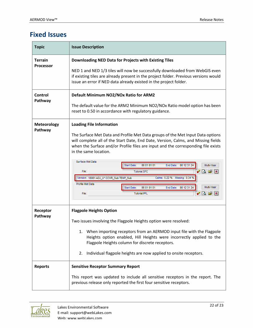
Terrain Processor
Downloading NED Data for Projects with Existing Tiles
NED 1 and NED 1/3 tiles will now be successfully downloaded from WebGIS even if existing tiles are already present in the project folder. Previous versions would issue an error if NED data already existed in the project folder.
Control Pathway
Default Minimum NO2/NOx Ratio for ARM2
The default value for the ARM2 Minimum NO2/NOx Ratio model option has been reset to 0.50 in accordance with regulatory guidance.
Meteorology Pathway
Loading File Information
The Surface Met Data and Profile Met Data groups of the Met Input Data options will complete all of the Start Date, End Date, Version, Calms, and Missing fields when the Surface and/or Profile files are input and the corresponding file exists in the same location.
Receptor Pathway
Flagpole Heights Option
Two issues involving the Flagpole Heights option were resolved:
1. When importing receptors from an AERMOD input file with the Flagpole Heights option enabled, Hill Heights were incorrectly applied to the Flagpole Heights column for discrete receptors.
2. Individual flagpole heights are now applied to onsite receptors.
Reports Sensitive Receptor Summary Report
This report was updated to include all sensitive receptors in the report. The previous release only reported the first four sensitive receptors.
AERMOD View™ Release Notes
23 of 23 Lakes Environmental Software
E-mail: [email protected]
Web: www.webLakes.com
Topic Issue Description
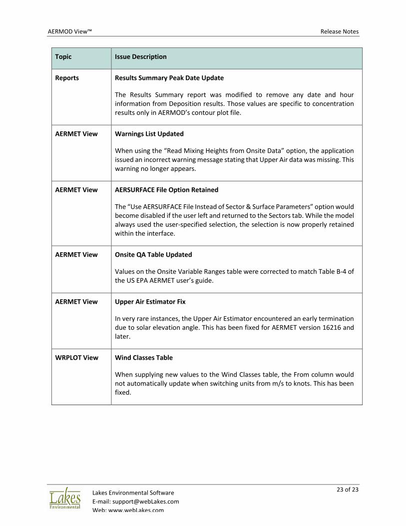
Reports Results Summary Peak Date Update
The Results Summary report was modified to remove any date and hour information from Deposition results. Those values are specific to concentration results only in AERMOD’s contour plot file.
AERMET View Warnings List Updated
When using the “Read Mixing Heights from Onsite Data” option, the application issued an incorrect warning message stating that Upper Air data was missing. This warning no longer appears.
AERMET View AERSURFACE File Option Retained
The “Use AERSURFACE File Instead of Sector & Surface Parameters” option would become disabled if the user left and returned to the Sectors tab. While the model always used the user-specified selection, the selection is now properly retained within the interface.
AERMET View Onsite QA Table Updated
Values on the Onsite Variable Ranges table were corrected to match Table B-4 of the US EPA AERMET user’s guide.
AERMET View Upper Air Estimator Fix
In very rare instances, the Upper Air Estimator encountered an early termination due to solar elevation angle. This has been fixed for AERMET version 16216 and later.
WRPLOT View Wind Classes Table
When supplying new values to the Wind Classes table, the From column would not automatically update when switching units from m/s to knots. This has been fixed.