adverse amenity impact assessment - air quality
TRANSCRIPT

SLR Ref: 640.12039-R01Version No: -v2.0September 2019
ADVERSE AMENITY IMPACT ASSESSMENT -AIR QUALITY
Proposed Mixed-Use Development272 Normanby Road South Melbourne
Prepared for:
Spec Property17 Batman Street
West Melbourne VIC 3003
Spec PropertyAdverse Amenity Impact Assessment - Air QualityProposed Mixed-Use Development272 Normanby Road South Melbourne
SLR Ref No: 640.12039-R01-v2.0.docxSeptember 2019
Page 2
PREPARED BY
SLR Consulting Australia Pty LtdABN 29 001 584 612Suite 2, 2 Domville AvenueHawthorn VIC 3122 Australia
T: +61 3 9249 9400E: [email protected] www.slrconsulting.com
BASIS OF REPORT
This report has been prepared by SLR Consulting Australia Pty Ltd (SLR) with all reasonableskill, care and diligence, and taking account of the timescale and resources allocated to itby agreement with Spec Property (the Client). Information reported herein is based onthe interpretation of data collected, which has been accepted in good faith as beingaccurate and valid.
This report is for the exclusive use of the Client. No warranties or guarantees areexpressed or should be inferred by any third parties. This report may not be relied uponby other parties without written consent from SLR.
SLR disclaims any responsibility to the Client and others in respect of any matters outsidethe agreed scope of the work.
DOCUMENT CONTROL
Reference Date Prepared Checked Authorised
640.12039-R01-v2.0 16 September 2019 Jason Shepherd Kirsten Lawrence Jason Shepherd
640.12039-R01-v1.0 27 August 2019 Jason Shepherd Kirsten Lawrence Jason Shepherd
Spec PropertyAdverse Amenity Impact Assessment - Air QualityProposed Mixed-Use Development272 Normanby Road South Melbourne
SLR Ref No: 640.12039-R01-v2.0.docxSeptember 2019
EXECUTIVE SUMMARY
Page 3
SLR was commissioned by Spec Property to perform an Adverse Amenity Impact Assessment, in relation to airquality and odour, for a proposed mixed-use residential development located at 272 Normanby Road, SouthMelbourne (the Development Site).
The assessment has considered the requirements of the Port Phillip Planning Scheme, the State EnvironmentProtection Policy (Air Quality Management) and the relevant National Environment Protection Measures withregard to the assessment method and criteria used. In completing the assessment of amenity impacts, referencewas also made to Environment Protection Authority Victoria publication ‘Recommended Separation Distancesfor Industrial Residual Air Emissions’.
Existing air quality and meteorological data collected in close proximity to the Development site have beenexamined which indicate that all pollutants, with the exception of particulate matter (often influenced byregional dust events), are within the required guideline values.
An examination of industrial and other operations surrounding the Development site has been performed, anda screening level assessment indicates that all identified operations in proximity to the Development site areunlikely to result in any constraints to the development with respect to air quality or odour issues. Consequently,with regard to encroachment of sensitive land uses on existing industrial uses, the proposed Development siteis unlikely to have any impact on the existing uses. No measures to mitigate potential amenity impacts aredeemed necessary.
Spec PropertyAdverse Amenity Impact Assessment - Air QualityProposed Mixed-Use Development272 Normanby Road South Melbourne
SLR Ref No: 640.12039-R01-v2.0.docxSeptember 2019
CONTENTS
Page 4
1 INTRODUCTION ........................................................................................................... 6
2 DEVELOPMENT REVIEW............................................................................................... 6
2.1 Development Site Location .......................................................................................... 6
2.2 Development Site Description ...................................................................................... 9
3 RELEVANT STANDARDS AND GUIDELINES ................................................................. 12
3.1 National Environment Protection Measures ............................................................... 12
3.1.1 Air NEPM ............................................................................................................................................... 12
3.1.2 Air Toxics NEPM..................................................................................................................................... 12
3.2 Victorian Environmental Legislation ........................................................................... 13
3.2.1 SEPP(AAQ) ............................................................................................................................................. 13
3.3 Recommended Separation Distances for Industrial Residual Air Emissions ................. 13
3.4 Victorian Planning Provisions ..................................................................................... 14
3.4.1 Port Philip Planning Scheme ................................................................................................................... 14
3.4.2 Threshold Distances ............................................................................................................................... 15
4 EXISTING ENVIRONMENT .......................................................................................... 15
4.1 Air Quality .................................................................................................................. 15
4.2 Meteorology .............................................................................................................. 17
5 ASSESSMENT METHODOLOGY ................................................................................... 19
5.1 Significance Assessment ............................................................................................. 19
5.1.1 Receptor Sensitivity ............................................................................................................................... 19
5.1.2 Magnitude of Impact ............................................................................................................................. 20
5.1.3 Resulting Impact Significance ................................................................................................................. 20
5.2 Risk Assessment ......................................................................................................... 20
5.2.1 Likelihood of Impact .............................................................................................................................. 20
5.2.2 Resulting Risk ........................................................................................................................................ 21
6 DESKTOP STUDY ........................................................................................................ 21
6.1 Potential Sources of Emissions to Air .......................................................................... 21
6.2 Recommended Separation Distances and Threshold Distances................................... 24
6.3 Existing Licence Conditions......................................................................................... 25
6.4 National Pollution Inventory (NPI) Sites ...................................................................... 25
7 ASSESSMENT ............................................................................................................. 25
7.1 Significance Assessment ............................................................................................. 25
7.1.1 Receptor Sensitivity ............................................................................................................................... 25
7.1.2 Magnitude of Impacts and Resulting Impact Significance ........................................................................ 26

Spec PropertyAdverse Amenity Impact Assessment - Air QualityProposed Mixed-Use Development272 Normanby Road South Melbourne
SLR Ref No: 640.12039-R01-v2.0.docxSeptember 2019
CONTENTS
Page 5
7.1.3 Summary ............................................................................................................................................... 31
7.2 Risk Assessment ......................................................................................................... 31
8 CONCLUSION ............................................................................................................. 32
9 REFERENCES .............................................................................................................. 33
DOCUMENT REFERENCES
TABLES
Table 1 Surrounding Land Uses .............................................................................................. 9Table 2 Air NEPM Standards and Goal .................................................................................. 12Table 3 Air Toxics NEPM Monitoring Investigation Levels ..................................................... 12Table 4 EPA Victoria AQMS Relevant to the Development Site ............................................. 15Table 5 Alphington AQMS Maximums .................................................................................. 16Table 6 Footscray AQMS Maximums .................................................................................... 16Table 7 Sensitivity of a Receptor to Air Quality Impacts ........................................................ 19Table 8 Potential Magnitude of Impact to Air Quality ........................................................... 20Table 9 Impact Significance Matrix ....................................................................................... 20Table 10 Likelihood of Impact to Air Quality ........................................................................... 21Table 11 Impact Risk Matrix ................................................................................................... 21Table 12 Surrounding Land Uses with Potential Sources of Emissions to Air ........................... 22Table 13 Recommended Separation Distances ....................................................................... 24Table 14 Threshold Distances ................................................................................................. 25Table 15 Potential Magnitude of Impacts from Surrounding Land Uses .................................. 26Table 16 Significance Assessment Results .............................................................................. 31Table 17 Potential Magnitude of Impacts from Surrounding Land Uses .................................. 32
FIGURES
Figure 1 Development Site Location – Greater Area ................................................................ 7Figure 2 Development Site Location – Immediate Area ........................................................... 8Figure 3 Development site Location – Existing Land Use ........................................................ 11Figure 4 Melbourne AWS Annual Morning (9.00 am) and Afternoon (3.00 pm) Wind
Roses (2018) ............................................................................................................ 17Figure 5 Melbourne AWS Annual and Seasonal Wind Roses (2018) ....................................... 18
Spec PropertyAdverse Amenity Impact Assessment - Air QualityProposed Mixed-Use Development272 Normanby Road South Melbourne
SLR Ref No: 640.12039-R01-v2.0.docxSeptember 2019
Page 6
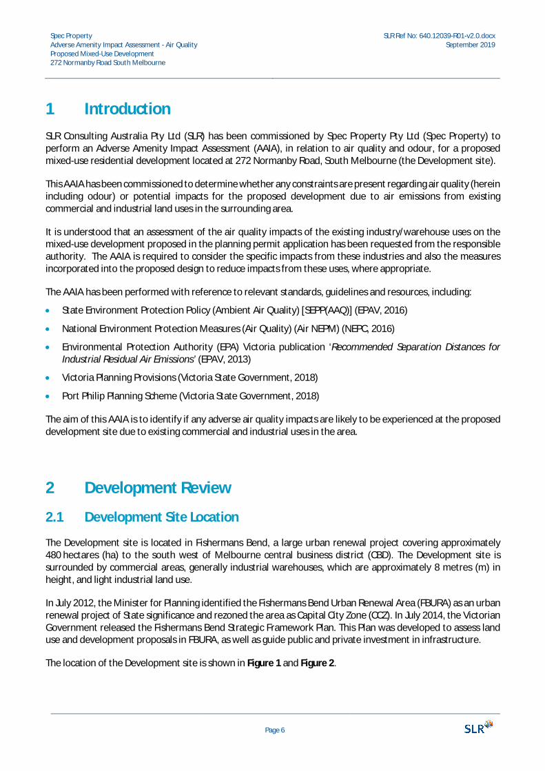
1 IntroductionSLR Consulting Australia Pty Ltd (SLR) has been commissioned by Spec Property Pty Ltd (Spec Property) toperform an Adverse Amenity Impact Assessment (AAIA), in relation to air quality and odour, for a proposedmixed-use residential development located at 272 Normanby Road, South Melbourne (the Development site).
This AAIA has been commissioned to determine whether any constraints are present regarding air quality (hereinincluding odour) or potential impacts for the proposed development due to air emissions from existingcommercial and industrial land uses in the surrounding area.
It is understood that an assessment of the air quality impacts of the existing industry/warehouse uses on themixed-use development proposed in the planning permit application has been requested from the responsibleauthority. The AAIA is required to consider the specific impacts from these industries and also the measuresincorporated into the proposed design to reduce impacts from these uses, where appropriate.
The AAIA has been performed with reference to relevant standards, guidelines and resources, including:
· State Environment Protection Policy (Ambient Air Quality) [SEPP(AAQ)] (EPAV, 2016)
· National Environment Protection Measures (Air Quality) (Air NEPM) (NEPC, 2016)
· Environmental Protection Authority (EPA) Victoria publication ‘Recommended Separation Distances forIndustrial Residual Air Emissions’ (EPAV, 2013)
· Victoria Planning Provisions (Victoria State Government, 2018)
· Port Philip Planning Scheme (Victoria State Government, 2018)
The aim of this AAIA is to identify if any adverse air quality impacts are likely to be experienced at the proposeddevelopment site due to existing commercial and industrial uses in the area.
2 Development Review
2.1 Development Site Location
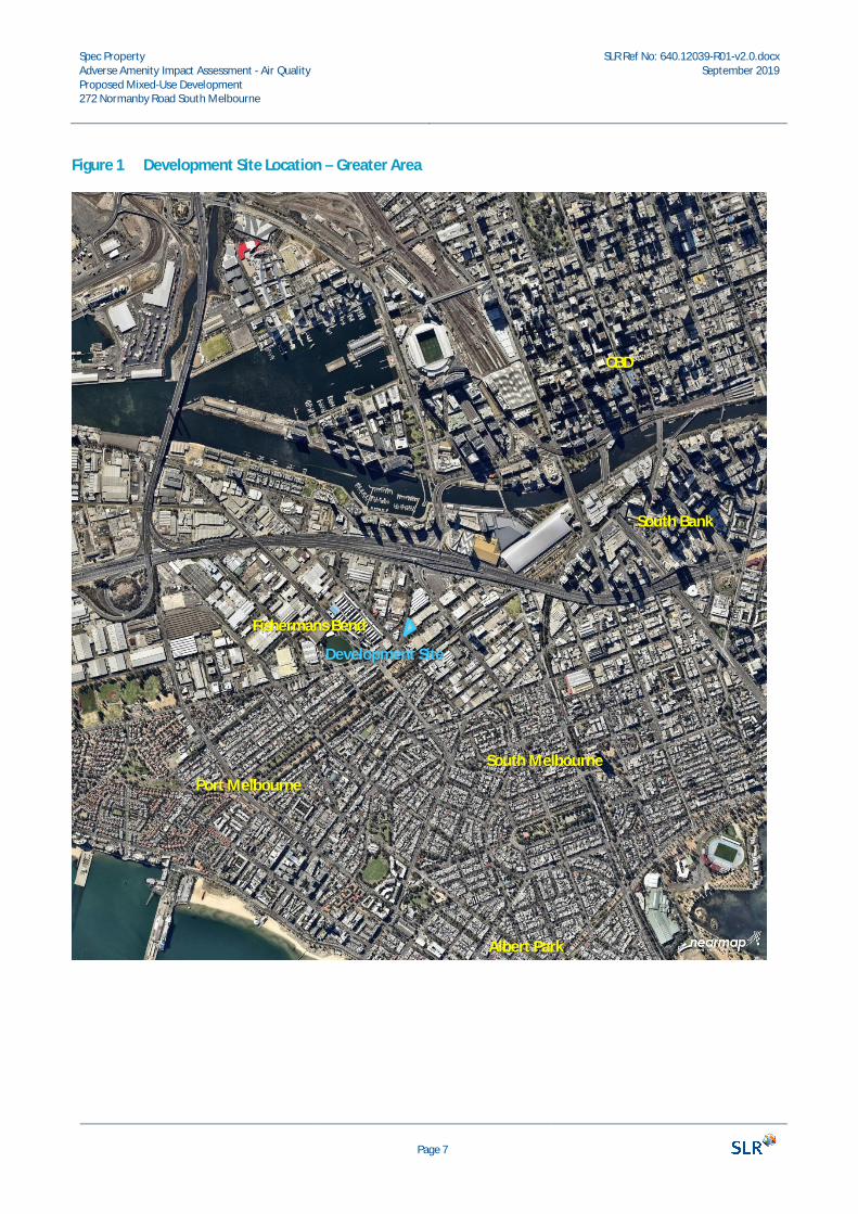
The Development site is located in Fishermans Bend, a large urban renewal project covering approximately480 hectares (ha) to the south west of Melbourne central business district (CBD). The Development site issurrounded by commercial areas, generally industrial warehouses, which are approximately 8 metres (m) inheight, and light industrial land use.
In July 2012, the Minister for Planning identified the Fishermans Bend Urban Renewal Area (FBURA) as an urbanrenewal project of State significance and rezoned the area as Capital City Zone (CCZ). In July 2014, the VictorianGovernment released the Fishermans Bend Strategic Framework Plan. This Plan was developed to assess landuse and development proposals in FBURA, as well as guide public and private investment in infrastructure.
The location of the Development site is shown in Figure 1 and Figure 2.
Spec PropertyAdverse Amenity Impact Assessment - Air QualityProposed Mixed-Use Development272 Normanby Road South Melbourne
SLR Ref No: 640.12039-R01-v2.0.docxSeptember 2019
Page 7
Figure 1 Development Site Location – Greater Area
Port Melbourne
Albert Park
South Melbourne
CBD
South Bank
Development Site
Fishermans Bend

Spec PropertyAdverse Amenity Impact Assessment - Air QualityProposed Mixed-Use Development272 Normanby Road South Melbourne
SLR Ref No: 640.12039-R01-v2.0.docxSeptember 2019
Page 8
Figure 2 Development Site Location – Immediate Area
DevelopmentSite
Spec PropertyAdverse Amenity Impact Assessment - Air QualityProposed Mixed-Use Development272 Normanby Road South Melbourne
SLR Ref No: 640.12039-R01-v2.0.docxSeptember 2019
Page 9
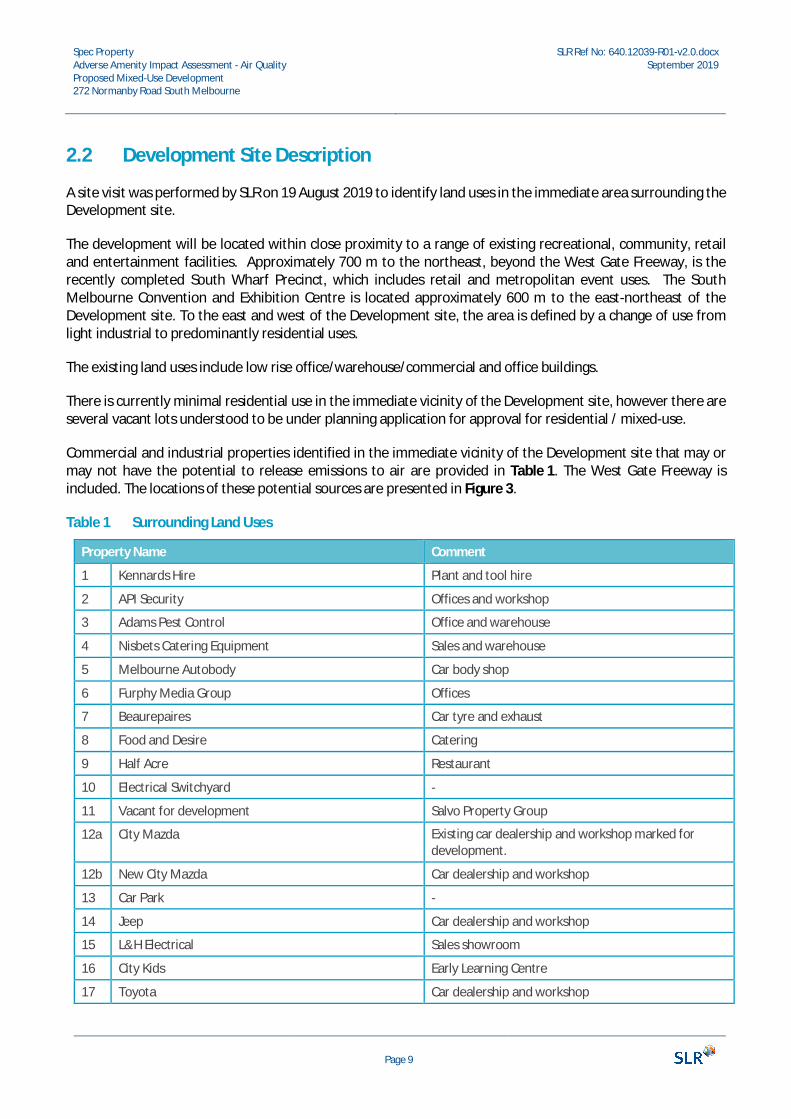
2.2 Development Site Description
A site visit was performed by SLR on 19 August 2019 to identify land uses in the immediate area surrounding theDevelopment site.
The development will be located within close proximity to a range of existing recreational, community, retailand entertainment facilities. Approximately 700 m to the northeast, beyond the West Gate Freeway, is therecently completed South Wharf Precinct, which includes retail and metropolitan event uses. The SouthMelbourne Convention and Exhibition Centre is located approximately 600 m to the east-northeast of theDevelopment site. To the east and west of the Development site, the area is defined by a change of use fromlight industrial to predominantly residential uses.
The existing land uses include low rise office/warehouse/commercial and office buildings.
There is currently minimal residential use in the immediate vicinity of the Development site, however there areseveral vacant lots understood to be under planning application for approval for residential / mixed-use.
Commercial and industrial properties identified in the immediate vicinity of the Development site that may ormay not have the potential to release emissions to air are provided in Table 1. The West Gate Freeway isincluded. The locations of these potential sources are presented in Figure 3.
Table 1 Surrounding Land Uses
Property Name Comment
1 Kennards Hire Plant and tool hire
2 API Security Offices and workshop
3 Adams Pest Control Office and warehouse
4 Nisbets Catering Equipment Sales and warehouse
5 Melbourne Autobody Car body shop
6 Furphy Media Group Offices
7 Beaurepaires Car tyre and exhaust
8 Food and Desire Catering
9 Half Acre Restaurant
10 Electrical Switchyard -
11 Vacant for development Salvo Property Group
12a City Mazda Existing car dealership and workshop marked fordevelopment.
12b New City Mazda Car dealership and workshop
13 Car Park -
14 Jeep Car dealership and workshop
15 L&H Electrical Sales showroom
16 City Kids Early Learning Centre
17 Toyota Car dealership and workshop

Spec PropertyAdverse Amenity Impact Assessment - Air QualityProposed Mixed-Use Development272 Normanby Road South Melbourne
SLR Ref No: 640.12039-R01-v2.0.docxSeptember 2019
Page 10
Property Name Comment
18 Access Self Storage and apartments Apartments are on the top two floors.
19 Douglas Partners Geotechnics office Offices; substation out the front.
20 SAE Qantm Educational training facility for sound engineering.
21 Autohaus Prestige Cars Car dealership and workshop
22 Vacant lot Awaiting development
23 Vipac Offices and laboratories. Includes cooling towers onroof, and ventilation fans on Normanby Road.
24 Sydney Tools Tools shop
25 Chase Auto Wholesalers Auto parts shop/warehouse
26 Teller Automotive Car dealership and workshop
27 Bridgestone Car tyre and exhaust
28 Fulton Hogan Truck sheds and laydown
29 Port Philip Resource Recovery Truck sheds and laydown
30 Hyundai Car dealership and workshop
31 Fight Fit Martial arts gym
32 Port Philip Resource Recovery Receiving general household rubbish, green waste etc.
33 Yarra Tram depot Workshop
34 Lavida Design Life / Gym Office/Showroom and martial arts gym
35 You Can Dance Studio Dance Studio.
36 CBD Car Wash and café -
37 JMA Architects Offices
38 More Telecom Offices, and office for lease
39 Barra Mechanical Repairs Car workshop
40 European Automotive Repairs Car workshop
41 Signwave Sign printing
42 Required Offices
43 Technetics IT Consultants
44 Spencer Panels Bodyshop
45 ALS Automotive Car workshop
46 Vacant workshop for lease Previously a car workshop
47 West Gate Freeway Traffic sources.
Spec PropertyAdverse Amenity Impact Assessment - Air QualityProposed Mixed-Use Development272 Normanby Road South Melbourne
SLR Ref No: 640.12039-R01-v2.0.docxSeptember 2019
Page 11
Figure 3 Development site Location – Existing Land Use
15
14
16
3635
47
DevelopmentSite
12
34
5
7
98
10
11
12b
3031
29
32
28
13
17
22
21
20
19
18
34
33
24
23
6
12a
39
38
37
45
41
44
4027
2625
4342
46
Spec PropertyAdverse Amenity Impact Assessment - Air QualityProposed Mixed-Use Development272 Normanby Road South Melbourne
SLR Ref No: 640.12039-R01-v2.0.docxSeptember 2019
Page 12
3 Relevant Standards and Guidelines
3.1 National Environment Protection Measures
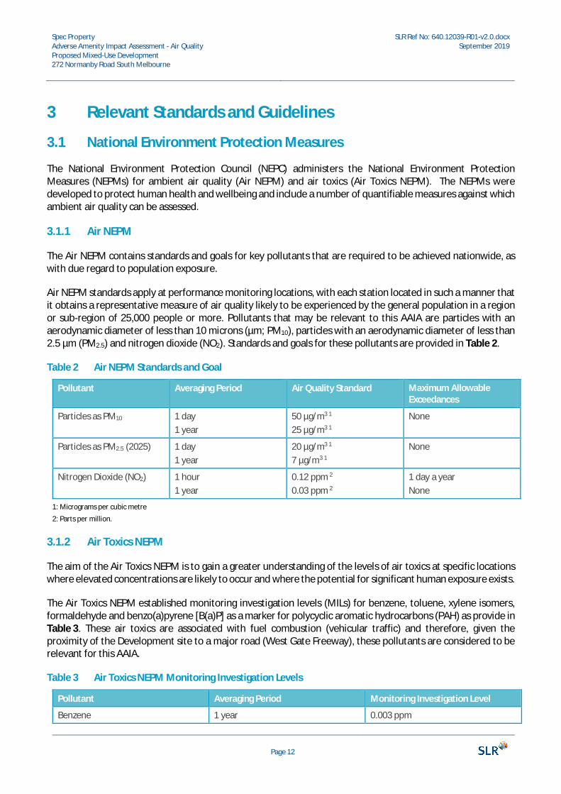
The National Environment Protection Council (NEPC) administers the National Environment ProtectionMeasures (NEPMs) for ambient air quality (Air NEPM) and air toxics (Air Toxics NEPM). The NEPMs weredeveloped to protect human health and wellbeing and include a number of quantifiable measures against whichambient air quality can be assessed.
3.1.1 Air NEPM
The Air NEPM contains standards and goals for key pollutants that are required to be achieved nationwide, aswith due regard to population exposure.
Air NEPM standards apply at performance monitoring locations, with each station located in such a manner thatit obtains a representative measure of air quality likely to be experienced by the general population in a regionor sub-region of 25,000 people or more. Pollutants that may be relevant to this AAIA are particles with anaerodynamic diameter of less than 10 microns (µm; PM10), particles with an aerodynamic diameter of less than2.5 µm (PM2.5) and nitrogen dioxide (NO2). Standards and goals for these pollutants are provided in Table 2.
Table 2 Air NEPM Standards and Goal
Pollutant Averaging Period Air Quality Standard Maximum AllowableExceedances
Particles as PM10 1 day1 year
50 µg/m3 1
25 µg/m3 1
None
Particles as PM2.5 (2025) 1 day1 year
20 µg/m3 1
7 µg/m3 1
None
Nitrogen Dioxide (NO2) 1 hour1 year
0.12 ppm 2
0.03 ppm 2
1 day a yearNone
1: Micrograms per cubic metre
2: Parts per million.
3.1.2 Air Toxics NEPM
The aim of the Air Toxics NEPM is to gain a greater understanding of the levels of air toxics at specific locationswhere elevated concentrations are likely to occur and where the potential for significant human exposure exists.
The Air Toxics NEPM established monitoring investigation levels (MILs) for benzene, toluene, xylene isomers,formaldehyde and benzo(a)pyrene [B(a)P] as a marker for polycyclic aromatic hydrocarbons (PAH) as provide inTable 3. These air toxics are associated with fuel combustion (vehicular traffic) and therefore, given theproximity of the Development site to a major road (West Gate Freeway), these pollutants are considered to berelevant for this AAIA.
Table 3 Air Toxics NEPM Monitoring Investigation Levels
Pollutant Averaging Period Monitoring Investigation Level
Benzene 1 year 0.003 ppm
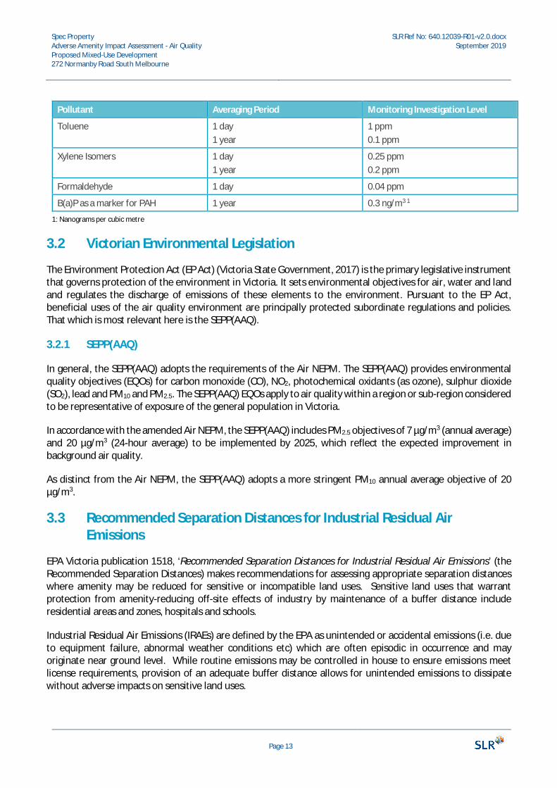
Spec PropertyAdverse Amenity Impact Assessment - Air QualityProposed Mixed-Use Development272 Normanby Road South Melbourne
SLR Ref No: 640.12039-R01-v2.0.docxSeptember 2019
Page 13
Pollutant Averaging Period Monitoring Investigation Level
Toluene 1 day1 year
1 ppm0.1 ppm
Xylene Isomers 1 day1 year
0.25 ppm0.2 ppm
Formaldehyde 1 day 0.04 ppm
B(a)P as a marker for PAH 1 year 0.3 ng/m3 1
1: Nanograms per cubic metre
3.2 Victorian Environmental Legislation
The Environment Protection Act (EP Act) (Victoria State Government, 2017) is the primary legislative instrumentthat governs protection of the environment in Victoria. It sets environmental objectives for air, water and landand regulates the discharge of emissions of these elements to the environment. Pursuant to the EP Act,beneficial uses of the air quality environment are principally protected subordinate regulations and policies.That which is most relevant here is the SEPP(AAQ).
3.2.1 SEPP(AAQ)
In general, the SEPP(AAQ) adopts the requirements of the Air NEPM. The SEPP(AAQ) provides environmentalquality objectives (EQOs) for carbon monoxide (CO), NO2, photochemical oxidants (as ozone), sulphur dioxide(SO2), lead and PM10 and PM2.5. The SEPP(AAQ) EQOs apply to air quality within a region or sub-region consideredto be representative of exposure of the general population in Victoria.
In accordance with the amended Air NEPM, the SEPP(AAQ) includes PM2.5 objectives of 7 µg/m3 (annual average)and 20 µg/m3 (24-hour average) to be implemented by 2025, which reflect the expected improvement inbackground air quality.
As distinct from the Air NEPM, the SEPP(AAQ) adopts a more stringent PM10 annual average objective of 20µg/m3.
3.3 Recommended Separation Distances for Industrial Residual AirEmissions
EPA Victoria publication 1518, ‘Recommended Separation Distances for Industrial Residual Air Emissions’ (theRecommended Separation Distances) makes recommendations for assessing appropriate separation distanceswhere amenity may be reduced for sensitive or incompatible land uses. Sensitive land uses that warrantprotection from amenity-reducing off-site effects of industry by maintenance of a buffer distance includeresidential areas and zones, hospitals and schools.
Industrial Residual Air Emissions (IRAEs) are defined by the EPA as unintended or accidental emissions (i.e. dueto equipment failure, abnormal weather conditions etc) which are often episodic in occurrence and mayoriginate near ground level. While routine emissions may be controlled in house to ensure emissions meetlicense requirements, provision of an adequate buffer distance allows for unintended emissions to dissipatewithout adverse impacts on sensitive land uses.
Spec PropertyAdverse Amenity Impact Assessment - Air QualityProposed Mixed-Use Development272 Normanby Road South Melbourne
SLR Ref No: 640.12039-R01-v2.0.docxSeptember 2019
Page 14
The Recommended Separation Distances is intended to support effective decision making with regard to landuses such that human health and wellbeing, local amenity and aesthetic enjoyment are protected from IRAEs,but also that existing industry is protected from encroachment by sensitive uses.
The encroachment of sensitive land uses on existing industrial uses has the potential to lead to the unwantedsituation where amenity at the sensitive land use is compromised and remedial action to alleviate off-siteimpacts from the industry is deemed uneconomical, such that the viability of the industry is jeopardised.
The compatibility of a proposed sensitive land use development with surrounding land uses and zones shouldtherefore be carefully assessed.
The Recommended Separation Distances lists a number of industries with their recommended IRAE separationdistances and recommends EPA consultation where site-specific circumstances indicate a lesser separationdistance may be appropriate (i.e. where there is no history of complaints arising from residual emissions orwhere the plant is significantly smaller than that used in the recommendations etc).
3.4 Victorian Planning Provisions
The Victoria Planning Provisions (VPP) is a state-wide reference document or template from which Victorianplanning schemes are sourced and constructed. Of relevance to the Development site is the Port Philip PlanningScheme.
3.4.1 Port Philip Planning Scheme
The purpose of the Port Philip Planning Scheme is:
· to provide a clear and consistent framework within which decisions about the use and development of landcan be made.
· to express state, regional, local and community expectations for areas and land uses.
· to provide for the implementation of State, regional and local policies affecting land use and development.
The Minister for Planning is responsible for making decisions on planning permit applications in FBURA wheredevelopment is located in specific areas and the application is for one of the following:
· Development with a building height of 4 storeys or greater
· Use and or/development for 60 or more dwellings
· Use and/or development with a gross floor area exceeding 10,000 square metres
· Use and or/development where any part of the land is owned by a public authority and/or municipal counciland the estimated cost of development is more than $10,000,000.
Clause 1.0 of Schedule 1 to the CCZ, FBURA in the Port Phillip Planning Scheme states that:
“An application to use land for any sensitive land use must be accompanied by the following information, asappropriate:
· a site plan that identifies the type and nature of the industrial/warehouse uses surrounding the site
· an assessment of the impact of the proposed accommodation use on existing industry/warehouse uses”
Spec PropertyAdverse Amenity Impact Assessment - Air QualityProposed Mixed-Use Development272 Normanby Road South Melbourne
SLR Ref No: 640.12039-R01-v2.0.docxSeptember 2019
Page 15
In addition to meeting the requirements of Clause 1.0 of Schedule 1 to the CCZ, FBURA, the Planning Minister,operating as the responsible authority, has requested an assessment of the impact of the existingindustry/warehouse uses on the mixed-use development proposed in the planning permit application.
In accordance with Clause 13.06-1S ‘Air quality management’ of Victoria Planning Provisions, all planning mustconsider the SEPP(AAQ) and the Recommended Separation Distances, as discussed in Section 3.3.
3.4.2 Threshold Distances
Clause 53.10 of the VPP discusses land uses with adverse amenity potential. The purpose of this clause is todefine those types of industries and warehouses which, if not appropriately designed and located, may causeoffense or unacceptable risk to the neighbourhood. Clause 53.10.-1 provides a table of Threshold Distances forvarious land uses, where the Threshold Distance is:
the minimum distance from any part of the land of the proposed use or buildings and works to land (nota road) in a residential zone, CZZ or Docklands Zone, land used for a hospital or an education centre orland in a Public Acquisition Overlay to be acquired for a hospital or an education centre.
4 Existing Environment
4.1 Air Quality
EPA Victoria conducts long term ambient air quality monitoring at performance monitoring stations to meet itsobligations under the Air NEPM. The closest and most representative air quality monitoring station (AQMS) tothe Development site is Melbourne CBD AQMS approximately 3.1 km northeast, however this station onlymonitors PM2.5 and as it is a relatively new addition to the network, no long-term historical data are available.Alphington AQMS and Footscray AQMS are further away, however these stations are well established andmonitor primary pollutants of interest in areas that could be described as being similar to the Development site,with residential and industrial elements.
A summary of these AQMS and the parameters monitored is provided in Table 4.
Table 4 EPA Victoria AQMS Relevant to the Development Site
AQMS Name Description Location in Relation to the Development Site Pollutants Monitored
Alphington Residential/lightindustrial
9.2 km to the northeast CONO2
PM10
PM2.5
Footscray Industrial/residential 7.1 km to the west-northwest. CONO2
PM10
PM2.5
Spec PropertyAdverse Amenity Impact Assessment - Air QualityProposed Mixed-Use Development272 Normanby Road South Melbourne
SLR Ref No: 640.12039-R01-v2.0.docxSeptember 2019
Page 16
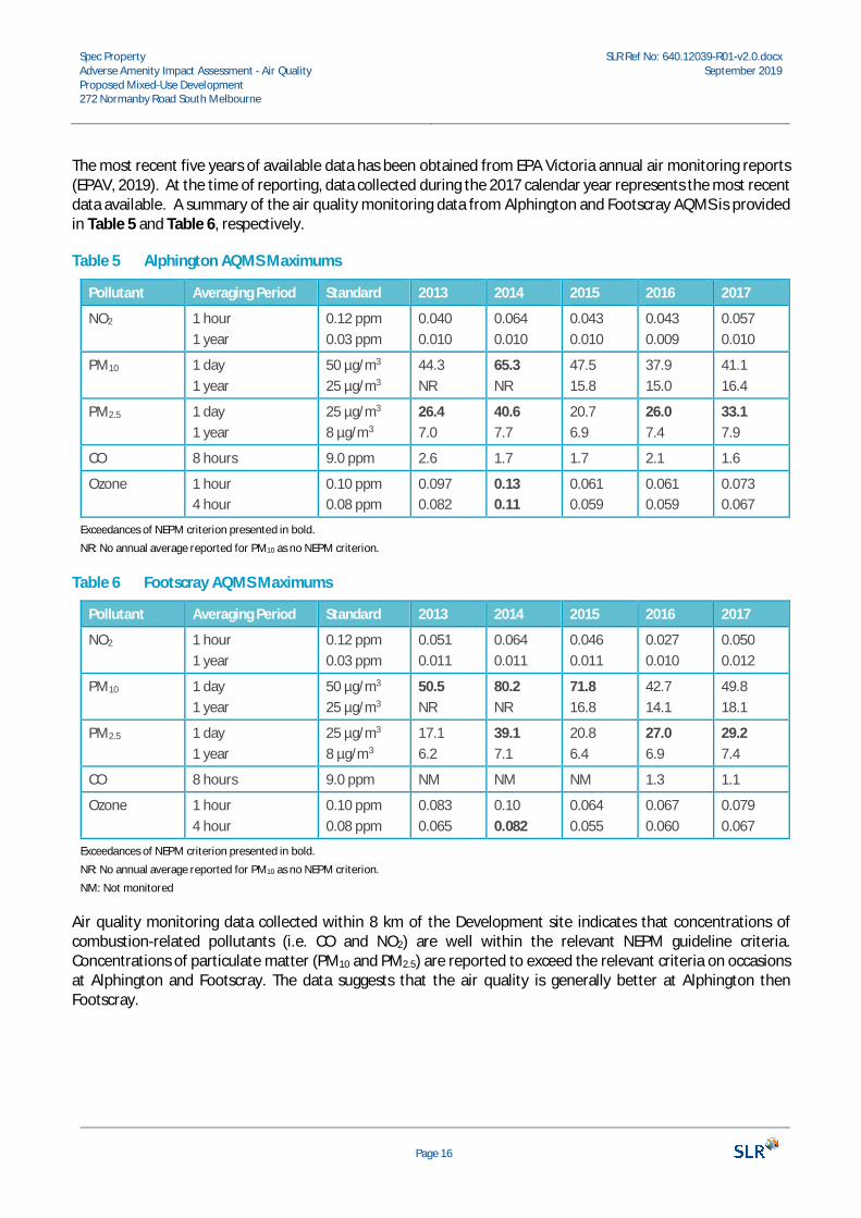
The most recent five years of available data has been obtained from EPA Victoria annual air monitoring reports(EPAV, 2019). At the time of reporting, data collected during the 2017 calendar year represents the most recentdata available. A summary of the air quality monitoring data from Alphington and Footscray AQMS is providedin Table 5 and Table 6, respectively.
Table 5 Alphington AQMS Maximums
Pollutant Averaging Period Standard 2013 2014 2015 2016 2017
NO2 1 hour1 year
0.12 ppm0.03 ppm
0.0400.010
0.0640.010
0.0430.010
0.0430.009
0.0570.010
PM10 1 day1 year
50 µg/m3
25 µg/m3
44.3NR
65.3NR
47.515.8
37.915.0
41.116.4
PM2.5 1 day1 year
25 µg/m3
8 µg/m3
26.47.0
40.67.7
20.76.9
26.07.4
33.17.9
CO 8 hours 9.0 ppm 2.6 1.7 1.7 2.1 1.6
Ozone 1 hour4 hour
0.10 ppm0.08 ppm
0.0970.082
0.130.11
0.0610.059
0.0610.059
0.0730.067
Exceedances of NEPM criterion presented in bold.
NR: No annual average reported for PM10 as no NEPM criterion.
Table 6 Footscray AQMS Maximums
Pollutant Averaging Period Standard 2013 2014 2015 2016 2017
NO2 1 hour1 year
0.12 ppm0.03 ppm
0.0510.011
0.0640.011
0.0460.011
0.0270.010
0.0500.012
PM10 1 day1 year
50 µg/m3
25 µg/m3
50.5NR
80.2NR
71.816.8
42.714.1
49.818.1
PM2.5 1 day1 year
25 µg/m3
8 µg/m3
17.16.2
39.17.1
20.86.4
27.06.9
29.27.4
CO 8 hours 9.0 ppm NM NM NM 1.3 1.1
Ozone 1 hour4 hour
0.10 ppm0.08 ppm
0.0830.065
0.100.082
0.0640.055
0.0670.060
0.0790.067
Exceedances of NEPM criterion presented in bold.
NR: No annual average reported for PM10 as no NEPM criterion.
NM: Not monitored
Air quality monitoring data collected within 8 km of the Development site indicates that concentrations ofcombustion-related pollutants (i.e. CO and NO2) are well within the relevant NEPM guideline criteria.Concentrations of particulate matter (PM10 and PM2.5) are reported to exceed the relevant criteria on occasionsat Alphington and Footscray. The data suggests that the air quality is generally better at Alphington thenFootscray.
Spec PropertyAdverse Amenity Impact Assessment - Air QualityProposed Mixed-Use Development272 Normanby Road South Melbourne
SLR Ref No: 640.12039-R01-v2.0.docxSeptember 2019
Page 17
On the basis of the data presented above, the air quality environment in the region surrounding theDevelopment site can be considered to be relatively good, however, traffic on the nearby West Gate Freeway islikely to contribute to CO, NO2, PM10 and PM2.5 concentrations at the Development site. Potential impacts onair quality at the Development site associated with local emission sources are considered in further detail inSection 7.
4.2 Meteorology
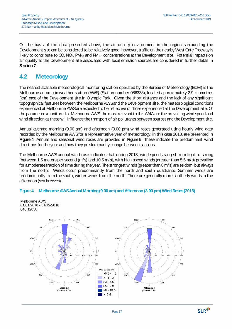
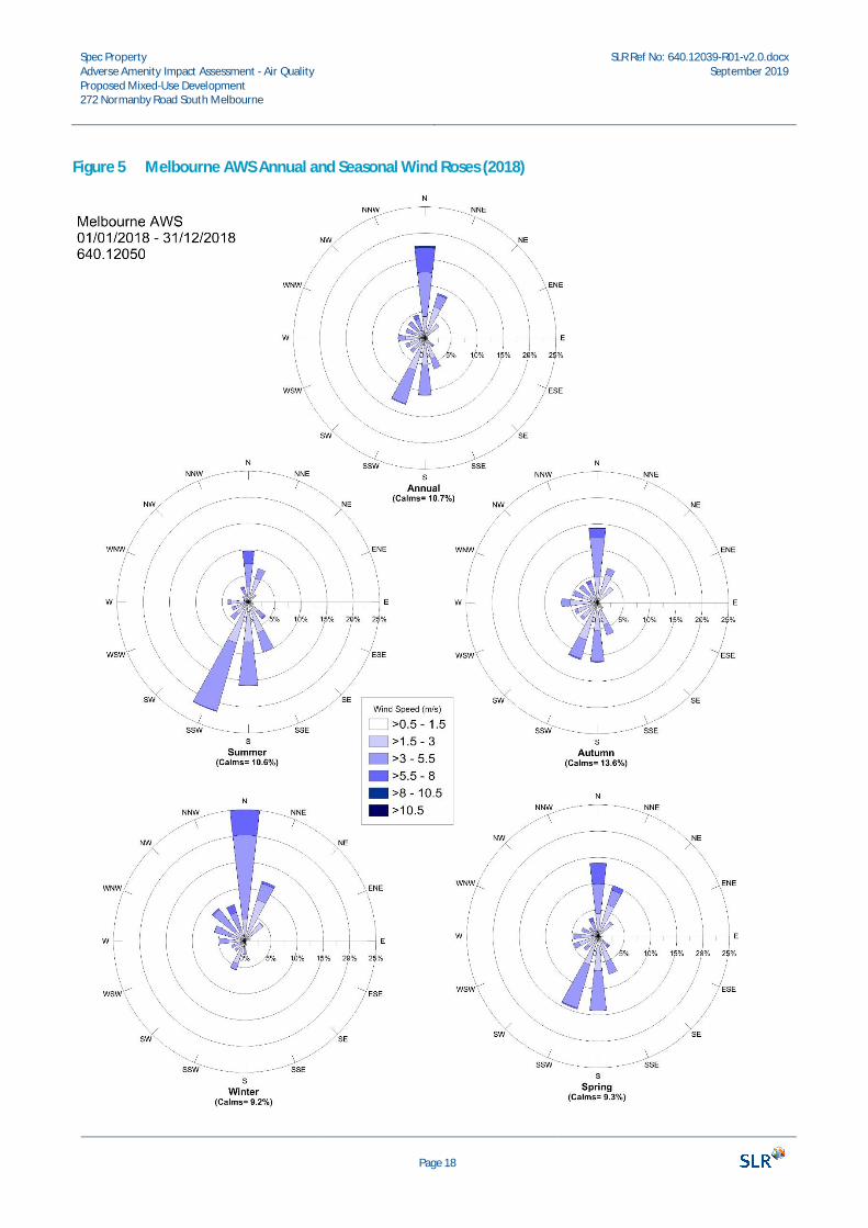
The nearest available meteorological monitoring station operated by the Bureau of Meteorology (BOM) is theMelbourne automatic weather station (AWS) (Station number 086338), located approximately 2.9 kilometres(km) east of the Development site in Olympic Park. Given the short distance and the lack of any significanttopographical features between the Melbourne AWS and the Development site, the meteorological conditionsexperienced at Melbourne AWS are expected to be reflective of those experienced at the Development site. Ofthe parameters monitored at Melbourne AWS, the most relevant to this AAIA are the prevailing wind speed andwind direction as these will influence the transport of air pollutants between sources and the Development site.
Annual average morning (9.00 am) and afternoon (3.00 pm) wind roses generated using hourly wind datarecorded by the Melbourne AWS for a representative year of meteorology, in this case 2018, are presented inFigure 4. Annual and seasonal wind roses are provided in Figure 5. These indicate the predominant winddirections for the year and how they predominantly change between seasons.
The Melbourne AWS annual wind rose indicates that during 2018, wind speeds ranged from light to strong[between 1.5 meters per second (m/s) and 10.5 m/s], with high speed winds (greater than 5.5 m/s) prevailingfor a moderate fraction of time during the year. The strongest winds (greater than 8 m/s) are seldom, but alwaysfrom the north. Winds occur predominantly from the north and south quadrants. Summer winds arepredominantly from the south, winter winds from the north. There are generally more southerly winds in theafternoon (sea breezes).
Figure 4 Melbourne AWS Annual Morning (9.00 am) and Afternoon (3.00 pm) Wind Roses (2018)
Spec PropertyAdverse Amenity Impact Assessment - Air QualityProposed Mixed-Use Development272 Normanby Road South Melbourne
SLR Ref No: 640.12039-R01-v2.0.docxSeptember 2019
Page 18
Figure 5 Melbourne AWS Annual and Seasonal Wind Roses (2018)
Spec PropertyAdverse Amenity Impact Assessment - Air QualityProposed Mixed-Use Development272 Normanby Road South Melbourne
SLR Ref No: 640.12039-R01-v2.0.docxSeptember 2019
Page 19
5 Assessment MethodologyPredictions of air quality impacts are necessary when appraising potential future impacts on sensitive land uses.
This AAIA first adopts a significance assessment approach to conservatively assess the potential significance ofthe adverse impact of emissions to air from the surrounding land uses. If required, (i.e. the potential forsignificant impact is indicated), a risk assessment of those impacts based on the likelihood of them occurring canbe used to refine the assessment.
5.1 Significance Assessment
The basis of the significance assessment method is an explicit assessment of the vulnerability of theenvironmental value (a resource or a sensitive receptor). It assumes that an impact will occur, with the worst-case scenario identified and assessed. The significance of the identified impact is assessed by considering thevulnerability or sensitivity of the environmental value and the magnitude of the impact.
Note that this AAIA is concerned only with adverse impacts and excludes sources that be considered beneficialor neutral to the receiving environment.
The significance assessment requires the following impact descriptors to be determined:
· Sensitivity: how sensitive is the receiving environment to the anticipated impacts? This may be applied tothe sensitivity of the environment in a regional context or specific receptor locations.
· Magnitude: what is the anticipated scale of the impact?
The integration of sensitivity with impact magnitude is used to derive the predicted significance of that change.
5.1.1 Receptor Sensitivity
Sensitivity may vary with the anticipated impact or effect. A receptor may have varying sensitivity to differentenvironmental changes, for example, a high sensitivity to changes in air quality, but low sensitivity to noiseimpacts. Sensitivity may also be derived from a statutory designation that is designed to protect the receptorfrom such impacts. Sensitivity terminology may vary depending upon the environmental effect, but generallythis may be described as very high, high, medium or low.
Table 7 outlines the methodology used in this study to define the sensitivity of receptors to air quality impacts.
Table 7 Sensitivity of a Receptor to Air Quality Impacts
Sensitivity Description
Very High Receptors of very high sensitivity to air pollution (e.g. dust or odour) such as: hospitals andclinics, retirement homes, painting and furnishing, hi-tech industries and food processing
High Receptors of high sensitivity to air pollution, such as: schools, residential areas, food retailers,glasshouses and nurseries, horticultural land and offices
Medium Receptors of medium sensitivity to air pollution, such as: farms, outdoor storage, light and heavyindustry
Low All other air quality sensitive receptors not identified above
Spec PropertyAdverse Amenity Impact Assessment - Air QualityProposed Mixed-Use Development272 Normanby Road South Melbourne
SLR Ref No: 640.12039-R01-v2.0.docxSeptember 2019
Page 20
5.1.2 Magnitude of Impact
Magnitude describes the anticipated scale of the anticipated environmental change in terms of how that impactmay cause a change to baseline conditions. Magnitude may be described quantitatively or qualitatively. Wherean impact is defined by qualitative assessment, the potential magnitude may be described as substantial,moderate, slight or negligible, with suitable justification is provided in the text.
Table 8 outlines the methodology used in this study to define the potential magnitude of impact to air quality.
Table 8 Potential Magnitude of Impact to Air Quality
Magnitude Description
Substantial Impact is predicted to cause significant consequences on the receiving environment
Moderate Impact is predicted to possibly cause statutory objectives/standards to be exceeded
Slight Predicted impact may be tolerated
Negligible Impact is predicted to cause no significant consequences.
5.1.3 Resulting Impact Significance
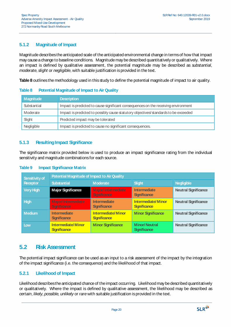
The significance matrix provided below is used to produce an impact significance rating from the individualsensitivity and magnitude combinations for each source.
Table 9 Impact Significance Matrix
Sensitivity ofReceptor
Potential Magnitude of Impact to Air Quality
Substantial Moderate Slight Negligible
Very High Major Significance Major/IntermediateSignificance
IntermediateSignificance
Neutral Significance
High Major/IntermediateSignificance
IntermediateSignificance
Intermediate/MinorSignificance
Neutral Significance
Medium IntermediateSignificance
Intermediate/MinorSignificance
Minor Significance Neutral Significance
Low Intermediate/MinorSignificance
Minor Significance Minor/NeutralSignificance
Neutral Significance
5.2 Risk Assessment
The potential impact significance can be used as an input to a risk assessment of the impact by the integrationof the impact significance (i.e. the consequence) and the likelihood of that impact.
5.2.1 Likelihood of Impact
Likelihood describes the anticipated chance of the impact occurring. Likelihood may be described quantitativelyor qualitatively. Where the impact is defined by qualitative assessment, the likelihood may be described ascertain, likely, possible, unlikely or rare with suitable justification is provided in the text.
Spec PropertyAdverse Amenity Impact Assessment - Air QualityProposed Mixed-Use Development272 Normanby Road South Melbourne
SLR Ref No: 640.12039-R01-v2.0.docxSeptember 2019
Page 21
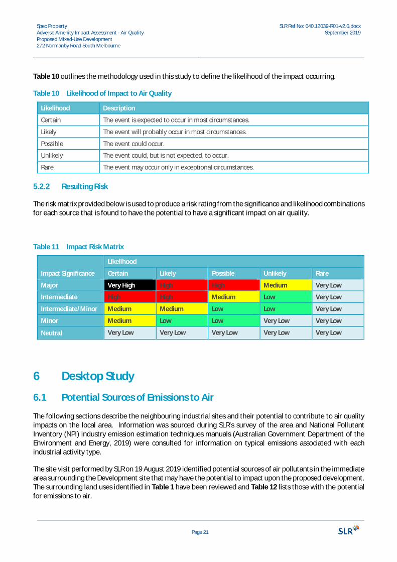
Table 10 outlines the methodology used in this study to define the likelihood of the impact occurring.
Table 10 Likelihood of Impact to Air Quality
Likelihood Description
Certain The event is expected to occur in most circumstances.
Likely The event will probably occur in most circumstances.
Possible The event could occur.
Unlikely The event could, but is not expected, to occur.
Rare The event may occur only in exceptional circumstances.
5.2.2 Resulting Risk
The risk matrix provided below is used to produce a risk rating from the significance and likelihood combinationsfor each source that is found to have the potential to have a significant impact on air quality.
Table 11 Impact Risk Matrix
Impact Significance
Likelihood
Certain Likely Possible Unlikely Rare
Major Very High High High Medium Very Low
Intermediate High High Medium Low Very Low
Intermediate/Minor Medium Medium Low Low Very Low
Minor Medium Low Low Very Low Very Low
Neutral Very Low Very Low Very Low Very Low Very Low
6 Desktop Study
6.1 Potential Sources of Emissions to Air
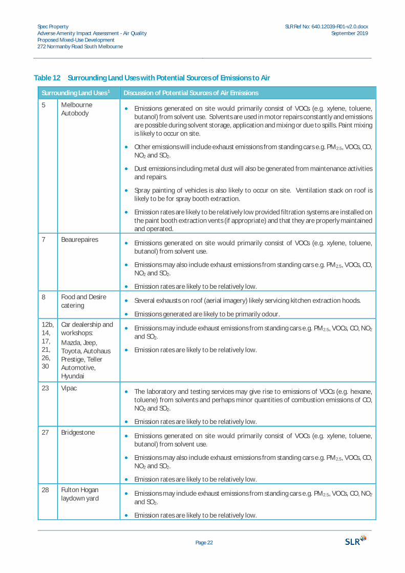
The following sections describe the neighbouring industrial sites and their potential to contribute to air qualityimpacts on the local area. Information was sourced during SLR’s survey of the area and National PollutantInventory (NPI) industry emission estimation techniques manuals (Australian Government Department of theEnvironment and Energy, 2019) were consulted for information on typical emissions associated with eachindustrial activity type.
The site visit performed by SLR on 19 August 2019 identified potential sources of air pollutants in the immediatearea surrounding the Development site that may have the potential to impact upon the proposed development.The surrounding land uses identified in Table 1 have been reviewed and Table 12 lists those with the potentialfor emissions to air.
Spec PropertyAdverse Amenity Impact Assessment - Air QualityProposed Mixed-Use Development272 Normanby Road South Melbourne
SLR Ref No: 640.12039-R01-v2.0.docxSeptember 2019
Page 22
Table 12 Surrounding Land Uses with Potential Sources of Emissions to Air
Surrounding Land Uses 1 Discussion of Potential Sources of Air Emissions
5 MelbourneAutobody
· Emissions generated on site would primarily consist of VOCs (e.g. xylene, toluene,butanol) from solvent use. Solvents are used in motor repairs constantly and emissionsare possible during solvent storage, application and mixing or due to spills. Paint mixingis likely to occur on site.
· Other emissions will include exhaust emissions from standing cars e.g. PM2.5, VOCs, CO,NO2 and SO2.
· Dust emissions including metal dust will also be generated from maintenance activitiesand repairs.
· Spray painting of vehicles is also likely to occur on site. Ventilation stack on roof islikely to be for spray booth extraction.
· Emission rates are likely to be relatively low provided filtration systems are installed onthe paint booth extraction vents (if appropriate) and that they are properly maintainedand operated.
7 Beaurepaires · Emissions generated on site would primarily consist of VOCs (e.g. xylene, toluene,butanol) from solvent use.
· Emissions may also include exhaust emissions from standing cars e.g. PM2.5, VOCs, CO,NO2 and SO2.
· Emission rates are likely to be relatively low.8 Food and Desire
catering· Several exhausts on roof (aerial imagery) likely servicing kitchen extraction hoods.
· Emissions generated are likely to be primarily odour.12b,14,17,21,26,30
Car dealership andworkshops:Mazda, Jeep,Toyota, AutohausPrestige, TellerAutomotive,Hyundai
· Emissions may include exhaust emissions from standing cars e.g. PM2.5, VOCs, CO, NO2
and SO2.
· Emission rates are likely to be relatively low.
23 Vipac · The laboratory and testing services may give rise to emissions of VOCs (e.g. hexane,toluene) from solvents and perhaps minor quantities of combustion emissions of CO,NO2 and SO2.
· Emission rates are likely to be relatively low.27 Bridgestone · Emissions generated on site would primarily consist of VOCs (e.g. xylene, toluene,
butanol) from solvent use.
· Emissions may also include exhaust emissions from standing cars e.g. PM2.5, VOCs, CO,NO2 and SO2.
· Emission rates are likely to be relatively low.28 Fulton Hogan
laydown yard· Emissions may include exhaust emissions from standing cars e.g. PM2.5, VOCs, CO, NO2
and SO2.
· Emission rates are likely to be relatively low.
Spec PropertyAdverse Amenity Impact Assessment - Air QualityProposed Mixed-Use Development272 Normanby Road South Melbourne
SLR Ref No: 640.12039-R01-v2.0.docxSeptember 2019
Page 23
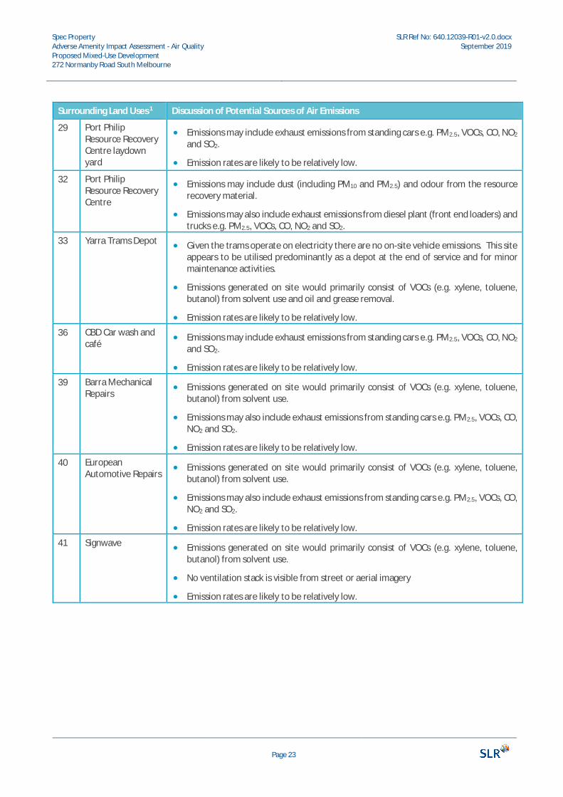
Surrounding Land Uses 1 Discussion of Potential Sources of Air Emissions
29 Port PhilipResource RecoveryCentre laydownyard
· Emissions may include exhaust emissions from standing cars e.g. PM2.5, VOCs, CO, NO2
and SO2.
· Emission rates are likely to be relatively low.
32 Port PhilipResource RecoveryCentre
· Emissions may include dust (including PM10 and PM2.5) and odour from the resourcerecovery material.
· Emissions may also include exhaust emissions from diesel plant (front end loaders) andtrucks e.g. PM2.5, VOCs, CO, NO2 and SO2.
33 Yarra Trams Depot · Given the trams operate on electricity there are no on-site vehicle emissions. This siteappears to be utilised predominantly as a depot at the end of service and for minormaintenance activities.
· Emissions generated on site would primarily consist of VOCs (e.g. xylene, toluene,butanol) from solvent use and oil and grease removal.
· Emission rates are likely to be relatively low.36 CBD Car wash and
café· Emissions may include exhaust emissions from standing cars e.g. PM2.5, VOCs, CO, NO2
and SO2.
· Emission rates are likely to be relatively low.39 Barra Mechanical
Repairs· Emissions generated on site would primarily consist of VOCs (e.g. xylene, toluene,
butanol) from solvent use.
· Emissions may also include exhaust emissions from standing cars e.g. PM2.5, VOCs, CO,NO2 and SO2.
· Emission rates are likely to be relatively low.40 European
Automotive Repairs· Emissions generated on site would primarily consist of VOCs (e.g. xylene, toluene,
butanol) from solvent use.
· Emissions may also include exhaust emissions from standing cars e.g. PM2.5, VOCs, CO,NO2 and SO2.
· Emission rates are likely to be relatively low.41 Signwave · Emissions generated on site would primarily consist of VOCs (e.g. xylene, toluene,
butanol) from solvent use.
· No ventilation stack is visible from street or aerial imagery
· Emission rates are likely to be relatively low.
Spec PropertyAdverse Amenity Impact Assessment - Air QualityProposed Mixed-Use Development272 Normanby Road South Melbourne
SLR Ref No: 640.12039-R01-v2.0.docxSeptember 2019
Page 24
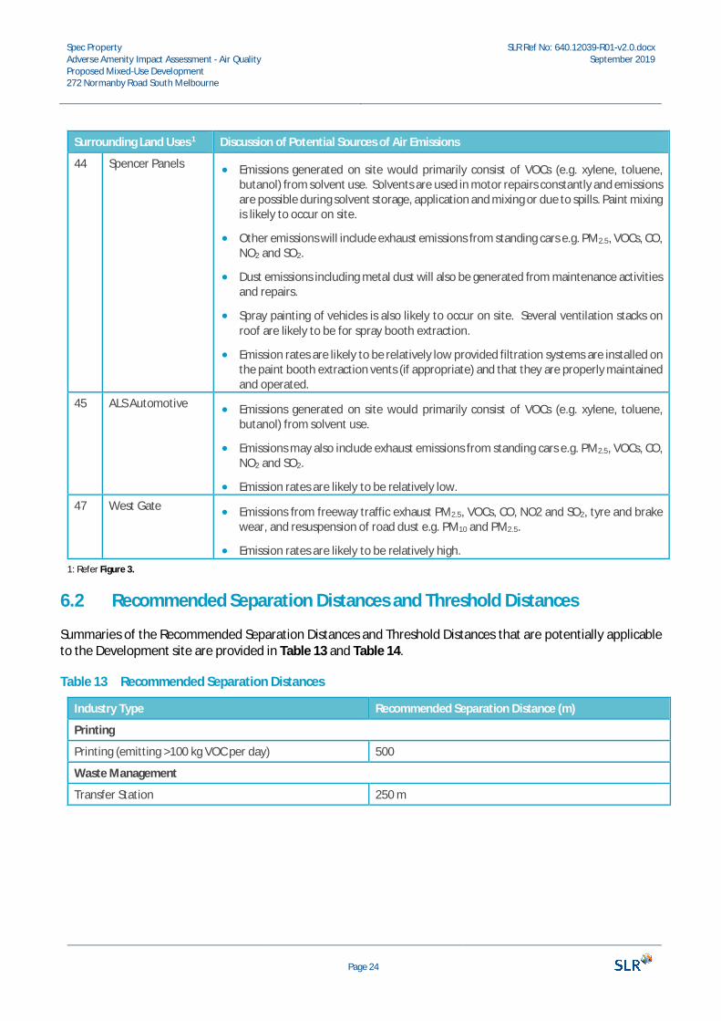
Surrounding Land Uses 1 Discussion of Potential Sources of Air Emissions
44 Spencer Panels · Emissions generated on site would primarily consist of VOCs (e.g. xylene, toluene,butanol) from solvent use. Solvents are used in motor repairs constantly and emissionsare possible during solvent storage, application and mixing or due to spills. Paint mixingis likely to occur on site.
· Other emissions will include exhaust emissions from standing cars e.g. PM2.5, VOCs, CO,NO2 and SO2.
· Dust emissions including metal dust will also be generated from maintenance activitiesand repairs.
· Spray painting of vehicles is also likely to occur on site. Several ventilation stacks onroof are likely to be for spray booth extraction.
· Emission rates are likely to be relatively low provided filtration systems are installed onthe paint booth extraction vents (if appropriate) and that they are properly maintainedand operated.
45 ALS Automotive · Emissions generated on site would primarily consist of VOCs (e.g. xylene, toluene,butanol) from solvent use.
· Emissions may also include exhaust emissions from standing cars e.g. PM2.5, VOCs, CO,NO2 and SO2.
· Emission rates are likely to be relatively low.47 West Gate · Emissions from freeway traffic exhaust PM2.5, VOCs, CO, NO2 and SO2, tyre and brake
wear, and resuspension of road dust e.g. PM10 and PM2.5.
· Emission rates are likely to be relatively high.1: Refer Figure 3.
6.2 Recommended Separation Distances and Threshold Distances
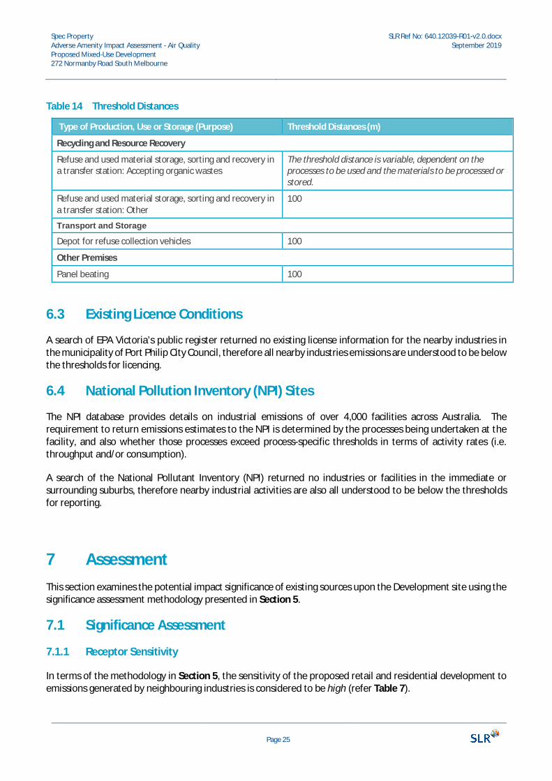
Summaries of the Recommended Separation Distances and Threshold Distances that are potentially applicableto the Development site are provided in Table 13 and Table 14.
Table 13 Recommended Separation Distances
Industry Type Recommended Separation Distance (m)
Printing
Printing (emitting >100 kg VOC per day) 500
Waste Management
Transfer Station 250 m
Spec PropertyAdverse Amenity Impact Assessment - Air QualityProposed Mixed-Use Development272 Normanby Road South Melbourne
SLR Ref No: 640.12039-R01-v2.0.docxSeptember 2019
Page 25
Table 14 Threshold Distances
Type of Production, Use or Storage (Purpose) Threshold Distances (m)
Recycling and Resource Recovery
Refuse and used material storage, sorting and recovery ina transfer station: Accepting organic wastes
The threshold distance is variable, dependent on theprocesses to be used and the materials to be processed orstored.
Refuse and used material storage, sorting and recovery ina transfer station: Other
100
Transport and Storage
Depot for refuse collection vehicles 100
Other Premises
Panel beating 100
6.3 Existing Licence Conditions
A search of EPA Victoria’s public register returned no existing license information for the nearby industries inthe municipality of Port Philip City Council, therefore all nearby industries emissions are understood to be belowthe thresholds for licencing.
6.4 National Pollution Inventory (NPI) Sites
The NPI database provides details on industrial emissions of over 4,000 facilities across Australia. Therequirement to return emissions estimates to the NPI is determined by the processes being undertaken at thefacility, and also whether those processes exceed process-specific thresholds in terms of activity rates (i.e.throughput and/or consumption).
A search of the National Pollutant Inventory (NPI) returned no industries or facilities in the immediate orsurrounding suburbs, therefore nearby industrial activities are also all understood to be below the thresholdsfor reporting.
7 AssessmentThis section examines the potential impact significance of existing sources upon the Development site using thesignificance assessment methodology presented in Section 5.
7.1 Significance Assessment
7.1.1 Receptor Sensitivity
In terms of the methodology in Section 5, the sensitivity of the proposed retail and residential development toemissions generated by neighbouring industries is considered to be high (refer Table 7).
Spec PropertyAdverse Amenity Impact Assessment - Air QualityProposed Mixed-Use Development272 Normanby Road South Melbourne
SLR Ref No: 640.12039-R01-v2.0.docxSeptember 2019
Page 26
7.1.2 Magnitude of Impacts and Resulting Impact Significance
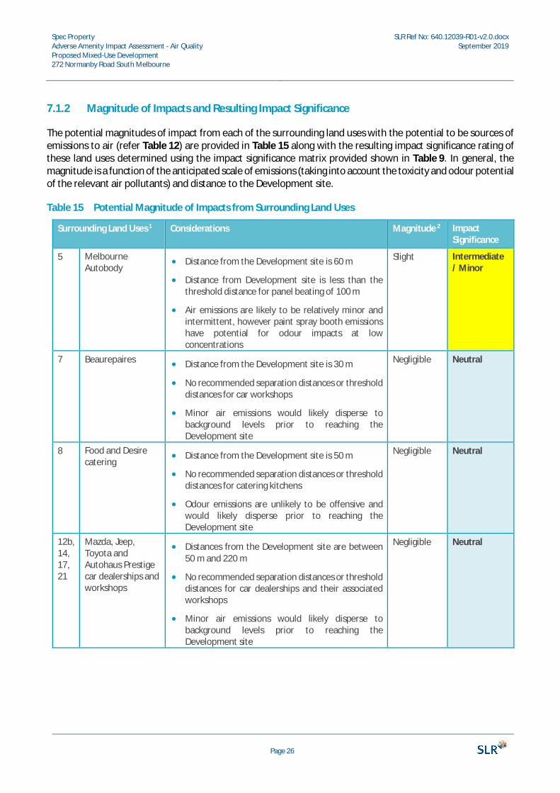
The potential magnitudes of impact from each of the surrounding land uses with the potential to be sources ofemissions to air (refer Table 12) are provided in Table 15 along with the resulting impact significance rating ofthese land uses determined using the impact significance matrix provided shown in Table 9. In general, themagnitude is a function of the anticipated scale of emissions (taking into account the toxicity and odour potentialof the relevant air pollutants) and distance to the Development site.
Table 15 Potential Magnitude of Impacts from Surrounding Land Uses
Surrounding Land Uses 1 Considerations Magnitude 2 ImpactSignificance
5 MelbourneAutobody
· Distance from the Development site is 60 m
· Distance from Development site is less than thethreshold distance for panel beating of 100 m
· Air emissions are likely to be relatively minor andintermittent, however paint spray booth emissionshave potential for odour impacts at lowconcentrations
Slight Intermediate/ Minor
7 Beaurepaires · Distance from the Development site is 30 m
· No recommended separation distances or thresholddistances for car workshops
· Minor air emissions would likely disperse tobackground levels prior to reaching theDevelopment site
Negligible Neutral
8 Food and Desirecatering
· Distance from the Development site is 50 m
· No recommended separation distances or thresholddistances for catering kitchens
· Odour emissions are unlikely to be offensive andwould likely disperse prior to reaching theDevelopment site
Negligible Neutral
12b,14,17,21
Mazda, Jeep,Toyota andAutohaus Prestigecar dealerships andworkshops
· Distances from the Development site are between50 m and 220 m
· No recommended separation distances or thresholddistances for car dealerships and their associatedworkshops
· Minor air emissions would likely disperse tobackground levels prior to reaching theDevelopment site
Negligible Neutral
Spec PropertyAdverse Amenity Impact Assessment - Air QualityProposed Mixed-Use Development272 Normanby Road South Melbourne
SLR Ref No: 640.12039-R01-v2.0.docxSeptember 2019
Page 27
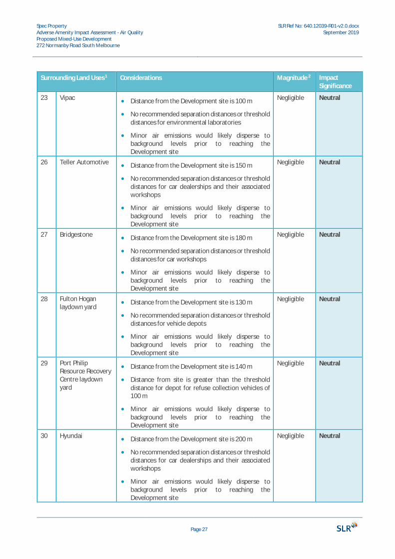
Surrounding Land Uses 1 Considerations Magnitude 2 ImpactSignificance
23 Vipac · Distance from the Development site is 100 m
· No recommended separation distances or thresholddistances for environmental laboratories
· Minor air emissions would likely disperse tobackground levels prior to reaching theDevelopment site
Negligible Neutral
26 Teller Automotive · Distance from the Development site is 150 m
· No recommended separation distances or thresholddistances for car dealerships and their associatedworkshops
· Minor air emissions would likely disperse tobackground levels prior to reaching theDevelopment site
Negligible Neutral
27 Bridgestone · Distance from the Development site is 180 m
· No recommended separation distances or thresholddistances for car workshops
· Minor air emissions would likely disperse tobackground levels prior to reaching theDevelopment site
Negligible Neutral
28 Fulton Hoganlaydown yard
· Distance from the Development site is 130 m
· No recommended separation distances or thresholddistances for vehicle depots
· Minor air emissions would likely disperse tobackground levels prior to reaching theDevelopment site
Negligible Neutral
29 Port PhilipResource RecoveryCentre laydownyard
· Distance from the Development site is 140 m
· Distance from site is greater than the thresholddistance for depot for refuse collection vehicles of100 m
· Minor air emissions would likely disperse tobackground levels prior to reaching theDevelopment site
Negligible Neutral
30 Hyundai · Distance from the Development site is 200 m
· No recommended separation distances or thresholddistances for car dealerships and their associatedworkshops
· Minor air emissions would likely disperse tobackground levels prior to reaching theDevelopment site
Negligible Neutral
Spec PropertyAdverse Amenity Impact Assessment - Air QualityProposed Mixed-Use Development272 Normanby Road South Melbourne
SLR Ref No: 640.12039-R01-v2.0.docxSeptember 2019
Page 28
Surrounding Land Uses 1 Considerations Magnitude 2 ImpactSignificance
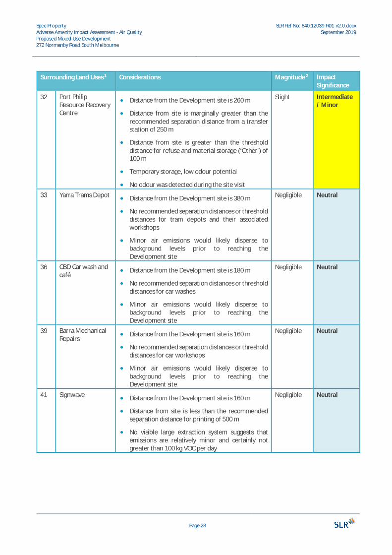
32 Port PhilipResource RecoveryCentre
· Distance from the Development site is 260 m
· Distance from site is marginally greater than therecommended separation distance from a transferstation of 250 m
· Distance from site is greater than the thresholddistance for refuse and material storage (‘Other’) of100 m
· Temporary storage, low odour potential
· No odour was detected during the site visit
Slight Intermediate/ Minor
33 Yarra Trams Depot · Distance from the Development site is 380 m
· No recommended separation distances or thresholddistances for tram depots and their associatedworkshops
· Minor air emissions would likely disperse tobackground levels prior to reaching theDevelopment site
Negligible Neutral
36 CBD Car wash andcafé
· Distance from the Development site is 180 m
· No recommended separation distances or thresholddistances for car washes
· Minor air emissions would likely disperse tobackground levels prior to reaching theDevelopment site
Negligible Neutral
39 Barra MechanicalRepairs
· Distance from the Development site is 160 m
· No recommended separation distances or thresholddistances for car workshops
· Minor air emissions would likely disperse tobackground levels prior to reaching theDevelopment site
Negligible Neutral
41 Signwave · Distance from the Development site is 160 m
· Distance from site is less than the recommendedseparation distance for printing of 500 m
· No visible large extraction system suggests thatemissions are relatively minor and certainly notgreater than 100 kg VOC per day
Negligible Neutral
Spec PropertyAdverse Amenity Impact Assessment - Air QualityProposed Mixed-Use Development272 Normanby Road South Melbourne
SLR Ref No: 640.12039-R01-v2.0.docxSeptember 2019
Page 29
Surrounding Land Uses 1 Considerations Magnitude 2 ImpactSignificance
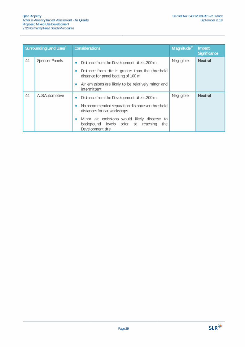
44 Spencer Panels · Distance from the Development site is 200 m
· Distance from site is greater than the thresholddistance for panel beating of 100 m
· Air emissions are likely to be relatively minor andintermittent
Negligible Neutral
44 ALS Automotive · Distance from the Development site is 200 m
· No recommended separation distances or thresholddistances for car workshops
· Minor air emissions would likely disperse tobackground levels prior to reaching theDevelopment site
Negligible Neutral
Spec PropertyAdverse Amenity Impact Assessment - Air QualityProposed Mixed-Use Development272 Normanby Road South Melbourne
SLR Ref No: 640.12039-R01-v2.0.docxSeptember 2019
Page 30
Surrounding Land Uses 1 Considerations Magnitude 2 ImpactSignificance
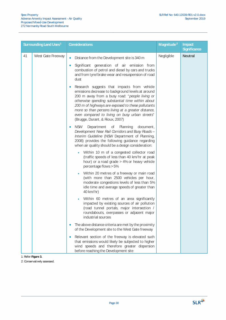
41 West Gate Freeway · Distance from the Development site is 340 m
· Significant generation of air emission fromcombustion of petrol and diesel by cars and trucksand from tyre/brake wear and resuspension of roaddust
· Research suggests that impacts from vehicleemissions decrease to background levels at around200 m away from a busy road: “people living orotherwise spending substantial time within about200 m of highways are exposed to these pollutantsmore so than persons living at a greater distance,even compared to living on busy urban streets”(Brugge, Durant, & Rioux, 2007)
· NSW Department of Planning document,Development Near Rail Corridors and Busy Roads –Interim Guideline (NSW Department of Planning,2008) provides the following guidance regardingwhen air quality should be a design consideration:
· Within 10 m of a congested collector road(traffic speeds of less than 40 km/hr at peakhour) or a road grade > 4% or heavy vehiclepercentage flows > 5%
· Within 20 metres of a freeway or main road(with more than 2500 vehicles per hour,moderate congestions levels of less than 5%idle time and average speeds of greater than40 km/hr)
· Within 60 metres of an area significantlyimpacted by existing sources of air pollution(road tunnel portals, major intersection /roundabouts, overpasses or adjacent majorindustrial sources
· The above distance criteria are met by the proximityof the Development site to the West Gate freeway
· Relevant section of the freeway is elevated suchthat emissions would likely be subjected to higherwind speeds and therefore greater dispersionbefore reaching the Development site
Negligible Neutral
1: Refer Figure 3.2: Conservatively assessed.
Spec PropertyAdverse Amenity Impact Assessment - Air QualityProposed Mixed-Use Development272 Normanby Road South Melbourne
SLR Ref No: 640.12039-R01-v2.0.docxSeptember 2019
Page 31
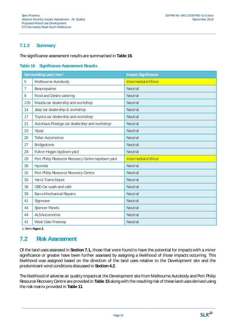
7.1.3 Summary
The significance assessment results are summarised in Table 16.
Table 16 Significance Assessment Results
Surrounding Land Uses 1 Impact Significance
5 Melbourne Autobody Intermediate/Minor
7 Beaurepaires Neutral
8 Food and Desire catering Neutral
12b Mazda car dealership and workshop Neutral
14 Jeep car dealership & workshop Neutral
17 Toyota car dealership and workshop Neutral
21 Autohaus Prestige car dealership and workshop Neutral
23 Vipac Neutral
26 Teller Automotive Neutral
27 Bridgestone Neutral
28 Fulton Hogan laydown yard Neutral
29 Port Philip Resource Recovery Centre laydown yard Intermediate/Minor
30 Hyundai Neutral
32 Port Philip Resource Recovery Centre Neutral
33 Yarra Trams Depot Neutral
36 CBD Car wash and café Neutral
39 Barra Mechanical Repairs Neutral
41 Signwave Neutral
44 Spencer Panels Neutral
44 ALS Automotive Neutral
41 West Gate Freeway Neutral
1: Refer Figure 3.
7.2 Risk Assessment
Of the land uses assessed in Section 7.1, those that were found to have the potential for impacts with a minorsignificance or greater have been further assessed by assigning a likelihood of those impacts occurring. Thislikelihood was assigned based on the direction of the land uses relative to the Development site and thepredominant wind conditions discussed in Section 4.2.
The likelihood of adverse air quality impacts at the Development site from Melbourne Autobody and Port PhilipResource Recovery Centre are provided in Table 15 along with the resulting risk of these land uses derived usingthe risk matrix provided in Table 11.
Spec PropertyAdverse Amenity Impact Assessment - Air QualityProposed Mixed-Use Development272 Normanby Road South Melbourne
SLR Ref No: 640.12039-R01-v2.0.docxSeptember 2019
Page 32
Table 17 Potential Magnitude of Impacts from Surrounding Land Uses
SurroundingLand Uses 1
ImpactSignificance
Considerations Likelihood Risk
5 MelbourneAutobody
Intermediate/ Minor
· Direction from the Development site is northeast
· Emissions require north-easterly winds, whichoccur less than 5% of the time, to impact theDevelopment site
Unlikely Low
32 Port PhilipResourceRecoveryCentre
Intermediate/ Minor
· Direction from the Development site is northwest
· Emissions require north-westerly winds, whichoccur less than 5% of the time, to blow theemissions 260 m to reach the Development site
Unlikely Low
1: Refer Figure 3.
8 Mitigation MeasuresDue to the low risk of potential adverse amenity impacts from the existing uses on the proposed Development,no mitigation measures are deemed necessary.
9 ConclusionAn AAIA, has been carried out to assess the potential air quality impact of existing nearby industries on theproposed mixed-used development at 272 Normanby Road, South Melbourne.
The AAIA presented in the report is based upon the continued operation of the existing or assumed processesthat have been considered.
The impact significance of each nearby land use with the potential to impact the Development site was assessedtaking into consideration the proximity of each identified air emission source, the industrial processes/materialsand equipment likely to be used and the typical emissions generated by each industry type. Those land uses thatwere found to have the potential for minor impact significance or greater were further assessed by assigning alikelihood of those impacts occurring based on the distance and direction of the land uses relative to theDevelopment site and the predominant wind conditions.
The AAIA concludes that the Development site may be considered suitable for residential land uses given thatthe surrounding land uses were found to pose a low risk of adverse air quality amenity. Consequently, withregard to encroachment of sensitive land uses on existing industrial uses, the proposed Development site isunlikely to have any impact on the existing uses. No measures to mitigate potential amenity impacts are deemednecessary.
Spec PropertyAdverse Amenity Impact Assessment - Air QualityProposed Mixed-Use Development272 Normanby Road South Melbourne
SLR Ref No: 640.12039-R01-v2.0.docxSeptember 2019
Page 33
10 ReferencesAustralian Government Department of the Environment and Energy. (2019, August 20). Emission estimation
technique manuals. Retrieved from National Pollution Inventory:http://www.npi.gov.au/reporting/industry-reporting-materials/emission-estimation-technique-manuals
Australian Government Department of the Environment and Energy. (2019, August 20). Latest NPI emission data- 2017-2018. Retrieved from National Pollution Inventory: http://www.npi.gov.au/npi-data/latest-data
Brugge, D., Durant, J. L., & Rioux, C. (2007). Near-highway pollutants in motor vehicle exhaust: A review ofepidemiologic evidence of cardiac and pulmonary health risks. Boston: Environmental Health.
EPAV. (2013, March 7). EPA Publication 1518 Recommended Separation Distances for Industrial Residual AirEmissions. Retrieved from Environmental Protection Authority Victoria:https://www.epa.vic.gov.au/our-work/publications/publication/2013/march/1518
EPAV. (2016, July 28). State Environment Protection Policy (Ambient Air Quality). Environment ProtectionAuthority. Melbourne, Vic, Australia: Victoria Government Gazette.
EPAV. (2019, August 20). Publications. Retrieved from EPA Victoria: https://www.epa.vic.gov.au/our-work/publications
National Environment Protection Council. (2016). National Environment Protection (Ambient Air Quality)Measure. Canberra: Department of the Environment.
NEPC. (2014). Draft Variation to the National Environment Protection (Ambient Air Quality) Measure. Canberra:National Environment Protection Council.
NEPC. (2016). National Environment Protection (Ambient Air Quality) Measure. Canberra: Department of theEnvironment: National Environment Protection Council.
NSW Department of Planning. (2008). Development Near Rail Corridors and Busy Roads - . Sydney: NSWDepartment of Planning.
Victoria State Government. (2017). Environment Protection Act. Melbourne, Victoria.Victoria State Government. (2018, July 31). Port Philip Planning Scheme. Melbourne, Victoria: Victoria State
Government.Victoria State Government. (2018, July 31). Victoria Planning Provisions. Melbourne, Victoria: Victoria State
Government.

ASIA PACIFIC OFFICES
BRISBANELevel 2, 15 Astor TerraceSpring Hill QLD 4000AustraliaT: +61 7 3858 4800F: +61 7 3858 4801
CANBERRAGPO 410Canberra ACT 2600AustraliaT: +61 2 6287 0800F: +61 2 9427 8200
DARWINUnit 5, 21 Parap RoadParap NT 0820AustraliaT: +61 8 8998 0100F: +61 8 9370 0101
GOLD COASTLevel 2, 194 Varsity ParadeVarsity Lakes QLD 4227AustraliaM: +61 438 763 516
MACKAY21 River StreetMackay QLD 4740AustraliaT: +61 7 3181 3300
MELBOURNESuite 2, 2 Domville AvenueHawthorn VIC 3122AustraliaT: +61 3 9249 9400F: +61 3 9249 9499
NEWCASTLE10 Kings RoadNew Lambton NSW 2305AustraliaT: +61 2 4037 3200F: +61 2 4037 3201
PERTHGround Floor, 503 Murray StreetPerth WA 6000AustraliaT: +61 8 9422 5900F: +61 8 9422 5901
SYDNEY2 Lincoln StreetLane Cove NSW 2066AustraliaT: +61 2 9427 8100F: +61 2 9427 8200
TOWNSVILLELevel 1, 514 Sturt StreetTownsville QLD 4810AustraliaT: +61 7 4722 8000F: +61 7 4722 8001
TOWNSVILLE SOUTH12 Cannan StreetTownsville South QLD 4810AustraliaT: +61 7 4772 6500
WOLLONGONGLevel 1, The Central BuildingUoW Innovation CampusNorth Wollongong NSW 2500AustraliaT: +61 404 939 922
AUCKLAND68 Beach RoadAuckland 1010New ZealandT: +64 27 441 7849
NELSON6/A Cambridge StreetRichmond, Nelson 7020New ZealandT: +64 274 898 628