advances and challenges of reservoir characterization: a review
TRANSCRIPT

9
Advances and Challenges of Reservoir Characterization:
A Review of the Current State-of-the-Art
Ailin Jia, Dongbo He and Chengye Jia Research Institute of Petroleum Exploration & Development, PetroChina
P. R. China
1. Introduction
Since the first technical paper which reported works of Jahns on two-dimensional description of reservoir heterogeneity using regression analysis on well testing data in 1966 (Jahns, 1966), reservoir characterization has attracted remarkable research efforts particularly in the past three decades (Doss et al., 2001; Wang, 2008). It is widely recognized now by oil industry that reservoir characteristics such as natural heterogeneity, spatial variability of permeability and porosity, porous media properties and spatial distribution of oil & water predominantly control the flow field, reservoir performance, development strategies and hence the economic returns of investments which are most concerned by oil companies. Reservoir characterization is a combined technology associated with geostatistics, geophsics,
petrophysics, geology and reservoir engineering and the main goals of reservoir
characterization research are to aid field development and reservoir management teams in
describing the reservoir in sufficient detail, developing 3D/4D data for reservoir
development planning to obtain higher recoveries with fewer wells in better positions at
minimum cost through optimization, increasing reserves, improving stimulation and
completion practices and reducing to a minimum uncertainty in production forecasts
(Haldorsen and Damsleth, 1993; Phillips, 1996; Johnston, 2004). In recent years, technological innovations have lead to advances of reservoir characterization through methodology and instruments. Terrestrial scanning lidar and laser technology were applied to outcrop stratigraphic mapping with extremely accurate and efficient for digital outcrop modeling (Bellian et al., 2005; Buckley et al., 2009). Seismic imaging technologies either single-sensor seismic data processing or calibration of seismic amplitude and attributes showed advantages in porosity detection and reservoir modeling (Slatt and Mark, 2002; Refae et al., 2008). Surface microseismic monitoring was also used for hydraulic-fracture monitoring in reservoir characterization of development stage (Duncan and Eisner, 2010). In this chapter, there are two main purposes of the author. One is to conduct a comprehensive review to the current state, challenges and developing trends of reservoir characterization technology. The second is trying to verify some phrases used in papers which are frequently used and affiliated to reservoir characterization and set up a practical procedure for people engaging or to be engaged in the field of reservoir characterization.
www.intechopen.com

Earth Sciences
206
2. Terminologies
Varies of words or phases were currently used by researchers to decorate "reservoir characterization". In related papers or literatures, digital detailed, comprehensive, advanced, integrated and practical are most frequent words ahead of reservoir characterization (Phillips 1996, Castillo et al., 1998; Montgomery and Morea, 2001; Slatt and Mark, 2002; Johnston, 2004; Jackson 2005; Jia and Cheng, 2010). Although technical features may be implicit in them, misunderstanding or confusion would also be associated with these terms. In this section, discussions on the differences between these decorative words were proposed. Phillips (1996) used the word "advanced" to decorate reservoir characterization. Three-dimensional deterministic and stochastic geologic models were developed integrated with pilot production and experiment. These works characterized heterogeneity of turbidite sands which do help to enhance sweep efficiency of steam injection for heavy oil recovery. Montgomery and Morea (2001) used the phase advanced reservoir characterization to summarize his work on three-dimensional earth modeling and flow simulation to evaluate CO2 injection for enhanced oil recovery of Antelope shale, Buena Vista Hills field. Advanced reservoir characterization of the Antelope shale zone has involved a wide range of specific analyses aimed at delineating the detailed rock and production characteristics of this complex unit. Mineralogic and petrologic studies, normal and specialized log analysis, and core analyses were performed, in addition to fluid characterization, fracture analysis, cross-well seismology, 3-D modeling, and flow simulation. It can be informed obviously that works summarized by authors to be advanced reservoir characterization are more comprehensive than traditional in which geological models were integrated with laboratory experiments, reservoir simulation or pilot production. Slatt and Mark (2002) purposed the challenges for independent operators with limited manpower and sources to select the right technique characterizing compartmentalized reservoir as reservoir performance is governed by complex features, which may be difficult to detect. Compartmentalized reservoirs may be resulted from primary stratigraphy or structure and are common to most types of sedimentary deposits. They can be discovered in fluvial deposits, eolian deposits, shoreface deposits, deltaic deposits and deep water (turbidite) deposits and practical methods to investigated flow units. Cores and logs are suggested to be the practical means for research on lithology, bed thickness and facies which affects porosity and permeability. Seismic analysis, borehole images and dipmeter reading used in combination can be effective for interwell petrophysical detection. Seismic imaging, core analysis and pressure tests can reveal complex fluvial and incised valley compartments. 3D modeling, sequence stratigraphy, outcrop analogs, interpretation of seismic data provide useful data on reservoir architecture, scale and connectivity of reservoir compartment. Reservoir compartments of sedimentary deposits were purposed and Practical reservoir characterization methods were summarized by selecting cost-effective technical means. Thus, practical reservoir characterization means a cost-effective manner to conduct reservoir characterization by selecting best available technologies to determine reservoir compartments. Reservoir characterization with 4D and four component (4C) seismic which result in data with both lower and higher frequencies than traditional systems and has materially reduced cross-talk onto incorrect channels was depicted as comprehensive reservoir characterization by Fageraas et al. (2003). 4C ocean bottom seismic arrays has the advantage for its ability to
www.intechopen.com

Advances and Challenges of Reservoir Characterization: A Review of the Current State-of-the-Art
207
acquire shear wave data directly which help address specific issues such as imaging through gas clouds and imaging low impedance reservoir. 4C/4D data can also provide a more accurate picture of dynamic reservoir processes because of its direct access to reservoir rock and fluid properties. Comparison between innovative 4C sensor technology and traditional systems reveals a significant improvement. Castillo et al. (1998) purposed an integrated model for the optimization and iterative integration of geophysical, geological, petrophysical and reservoir engineering data. Reservoir interval architectures were determined through description, correlation and cartography of geological data. Genetic or stratigraphic units and reservoir compartments were identified by structural-stratigraphic interpretation of 3D seismic survey and well logs. Then, production was incorporated and integrated and reservoir model was generated. Dynamic simulation was conducted and potentially recoverable reserves were forecasted. In this work, an integrated geological model was developed with support of seismic 3D interpretation, advance sequence analysis, petrophysics and fluid data analysis and the author summarized it as integrated reservoir characterization. Jia and Cheng (2010) summarized methods for detailed, digital and integrative reservoir characterization in the mid-late stages of oilfield development and specified the definition of detailed digital reservoir characterization. Compared with traditional approaches, detailed digital reservoir characterization is more closely related to "digital reservoir". It is characterized of visualization and integration with geological analysis, seismic interpretation, well logs, production and artificial intelligence. The author pointed out that detailed digital reservoir characterization aims to enhance oil recovery and remaining oil development at the middle or mature stage of field development and its core mission is to realize high precision reservoir prediction and quantitative assessment to reservoir architecture. It is characterized of quantitative, detailed, visible and integrated. As words decorative to the phase "reservoir characterization", advanced, practical, comprehensive, integrated, digital and detailed have their unique technique contents or features. Advance reservoir characterization has more emphasis on integration of geological model with flow simulation, or pilot production and production forecast. Practical reservoir characterization aims at cost-effectiveness for independent operators to choose appropriate techniques conducting characterize reservoir compartments of different kinds of deposits. Comprehensive reservoir characterization has the features of 4C/4D technical innovation for improvement of reservoir imaging. Integrated reservoir characterization underlines the calibration and integration of different kinds of data, such as geophysical, geological, petrophysical and reservoir engineering data. Digital and detailed reservoir characterization has more particularity in visualization.
3. Advances of reservoir characterization technology
Reservoir characterization has attracted remarkable research efforts particularly over the past 20 years. Material improvements and technical innovations have lead to the advances of reservoir characterization technology. These improvements or innovations which improve reservoir characterization technology can be summarized into two aspects. One is that advanced instruments and technologies applied in data gathering, processing and monitoring have improved quality and reliability of test data. The second is that the development of related technology such as computer science and information science has realized comprehensive integration of reservoir characterization with outcrop analogues,
www.intechopen.com

Earth Sciences
208
seismic, geology and well logs and made the subsurface reservoir model, output of reservoir characterization study into digital 3D visible model. In this section, some technological advances were selected and introduced by the author according his knowledge degree.
3.1 Reservoir characterization and monitoring with 4D seismic Seismic time-lapse reservoir monitoring (4D) was used to access the petrophysical
properties and performance of reservoir at stage of field development in recent years
(Fageraas et al., 2003; Kovacic and Poggiagliomi, 2003). Reservoir characterization and
monitoring with 4D seismic data involves both comparison and analysis of repeated seismic
surveys shot over the same location during the production life of a field. Compared with
borehole based measurements (logs, pressure, temperature, etc), property distributions
obtained from seismic attributes have more advantages in accuracy and spatial resolution.
Basic methodologies, dealing with some of the most critical issues and phases encountered
in a seismic time-lapse project, were developed by Kovacic and Poggiagliomi: (1) feasibility
studies to assess the suitability of time-lapse seismic technology to monitor the performance
of a specific reservoir. This includes fully integrating laboratory measurements performed
on core samples, well data analysis (editing and normalization of well logs), rock
mechanical modeling, rock physics data and petroacoustic processing and Its purpose is to
assess whether acoustic changes, related to time-lapse fluid movements within the
production intervals, are of sufficient magnitude to be detected seismically.; (2) accurate
homogenization of legacy 3D seismic surveys by means of wavelet equalization. In this
phase, two 3D surveys were processed and wavelet-equalized by extracting from all the
traces in trace-sets, located at the same well position, with the same well-log derived
reflectivity sequence.; (3) calibration of absolute acoustic impedance volumes to reservoir
pressure and petrophysical properties (porosity, saturation, clay content, etc.) to derive the
spatial pattern of fluid movements.
Through reservoir characterization with 4D seismic, partially drained areas can be
recognized by analysis to pattern of acoustic impedance and quantified by petroacoustic
calibration. Thus, remaining reserves can be evaluated which is one of the main purposes of
reservoir characterization study.
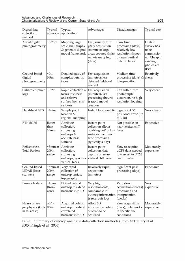
3.2 Outcrop study with application of digital data capture technology Outcrop studies have long been employed as a mechanism of studying analogues and understanding petroleum fields (Collinson, 1970; Glennie, 1970; Breed and Grow, 1979). Depositional architectures are well preserved in outcrops and outcrop analogues offer the opportunity to enhance the understanding of subsurface reservoir architecture, geometry, and facies distributions (Pringle et al., 2006). Compared to studies of modern sedimentary events or laboratory-based experiments and process-based modeling, outcrops are more geologically comparable to the subsurface reservoir architecture and capture large enough scale of heterogeneity. Outcrop studies have developed from qualitative to quantitative. Traditional outcrop studies were focused on collecting outcrop data, such as sand width, thickness, to populate inter-well areas by stochastic or object-based methods (Dreyer et al., 1993; Bryant and Flint, 1993; Chapin et al., 1994; Clark and Pickering, 1996; Reynolds, 1999; Floris and Peersmann, 2002). However, traditional outcrop studies can hardly provide useful data especially when it needs to be integrated into reservoir engineering database or be visualized in 3D. Accurate
www.intechopen.com
Advances and Challenges of Reservoir Characterization: A Review of the Current State-of-the-Art
209
Digital data collection method
Typical accuracy
Typical application
Advantages Disadvantages Typical cost
Aerial digital photogrammetry
~5-25m Mapping large scale stratigraphy & generate digital model framework
Fast, usually third party acquisition (minutes); large areas covered & fast remote mapping (days)
Slow time processing (days); relatively low resolution & poor on near vertical outcrop faces
High if survey has to be commissioned. Cheap if existing photos are used
Ground-based digital photogrammetry
~0.1-0.5m
Detailed study of complex outcrop faces
Fast acquisition (minutes); less detailed fieldwork needed
Medium time processing (days) & interpretation
Relatively cheap
Calibrated photo logs
~0.2m Rapid collection of facies thickness and relative surface from cliff sections
Fast acquisition (minutes), fast processing (hours) & rapid model creation
Can suffer from photograph distortion, no high resolution logging
Very cheap
Hand-held GPS ~1-5m Sample point location & regional mapping
Instant locational fix Significant ‘Z’ positional error (up to 30m)
Very cheap
RTK dGPS Better than 10mm
Attribute collection, surveying outcrops & accurate base stations
Instant point collection allows ‘walking out’ of key surfaces, medium time processing (typically a day)
Not possible on near vertical cliff-faces
Expensive
Reflectorless Total Station
~3mm at 200m range
Attribute collection, surveying outcrops, good for vertical faces
Instant point collection, data capture on near-vertical cliff faces
Slow to acquire, dGPS data needed to convert to UTM co-ordinates
Moderately expensive
Ground-based LIDAR (laser scanner)
~5mm at 200m range
Very rapid collection of outcrop surface topography
Relatively rapid acquisition (minutes)
Significant post processing (days)
Expensive
Bore-hole data ~1mm (from core)
Drilled behind outcrop to extend horizons into 3D
Very high resolution data, comparable to outcrop information & reservoir logs
Very slow acquisition (weeks), processing and interpretation (weeks)
Very expensive
Near-surface geophysics (GPR in this case)
~0.1-0.5m
Acquired behind outcrop to extend correlated horizons into 3D
Allow 3D information behind outcrop to be acquired
Slow acquisition (days), only works in specific site conditions
Moderately expensive
Table 1. Summary of outcrop analogue data collection methods (From McCaffery et al., 2005; Pringle et al., 2006)
www.intechopen.com

Earth Sciences
210
Fig. 1. Workflow diagram for digital outcrop study. Black arrows indicate flow direction and red arrows indicate feedback. (From Bellian et al., 2005).
and quantitative outcrop analogue supported by digital data capture technique has been developed in recent years and it realized 3D reconstruction to aid or modify subsurface reservoir model. Varies of digital data capture techniques are listed in table 1 and application of advance techniques allow rapid acquisition of more accurate and denser digital datasets from outcrop. In table 1, accuracy, application condition, advantages and disadvantages for specific method have been summarized by McCaffrey et al. (2005) Currently, ground-based LIDAR (Light Detection and Ranging) or laser scanning is the preferred technology (Pringle et al, 2006). Lidar scanner uses laser light to measure distance with extreme precision, whereas radar scanner uses radio waves. They use “time of travel” to measure the distance. Resolution of radar scanner is about 8mm at range of 350m and it is almost 5mm at range of 200m for lidar scanner. Data extracted from digital outcrop model can be incorporated into reservoir model. Details for scanning lidar and radar technology with its application in digital outcrop study can be referred in paper purposed by Bellian et al. (2005) and Buckley et al. (2009).
www.intechopen.com

Advances and Challenges of Reservoir Characterization: A Review of the Current State-of-the-Art
211
3.3 Reservoir characterization using downhole/surface microseismic monitoring Microseismic imagining has been applied for downhole monitoring especially to image fracture network deformation of hydraulic fracture operations (Bailey, 1973; Duncan and Eisner, 2010; Maxwell et al., 2010). To plot the estimates of the event hypocenter locations on an event-by-event basis over time is currently the common practice for reporting the result of microseismic monitoring. As shown in Figure 2, the hypocenter locations for a multiwell frac for five horizontal wells in Marcellus Shale play are estimated.
Fig. 2. Perspective view of the microseismic monitoring results from treating five wells completed in the Marcellus Shale in Pennsylvania. The dots represent the estimated event hypocenters. The colors of the dots match the color of the treated well to which they correspond. (From Schisselé and Meunier, 2009; Duncan and Eisner, 2010).
Maxwell et al. (2010) listed three general classes of techniques for locating microseismic events: (1) hodogram techniques based upon the particle motion of direct arrivals, which is the simplest method and using only one three-component (3C) sensor (Albright and Hanold, 1976), (2) triangulation schemes based upon arrival times of direct waves by combinations of P- and/or S-waves at multiple stations (Gibowicz and Kijko, 1994), and (3) semblance methods based upon stacking waves without arrival-time picking. All three classes of location techniques can be used in conjunction with surface or downhole sensors (Duncan and Eisner, 2010). However, many researchers have developed other approaches on passive seismic emission tomography such as long-time-interval stacking similar to semblance (Kuznetsov et al., 2006; Kochnev et al., 2007) and picking the maximum amplitude of the P-wave migration as
www.intechopen.com

Earth Sciences
212
the imaging condition (Chambers et al., 2008, 2009a, 2009b; Robein et al., 2009). A method to improve resolution for amplitude picking through recognizing the vertical distribution of false hypocenter estimates for has been purposed by Duncan et al. (2008). Surface monitoring technique of hydraulic fracture stimulation also has been developed (Abbott et al., 2007; Kochnev et al., 2007; Barker, 2009; Hall and Kilpatrick, 2009; Keller et al., 2009; Robein et al., 2009). Usually linear groups of vertical phones are laid out along the spokes of a wheel centered on the wellhead of the treatment well. Details of data gathering, processing and migration about the technique have been investigated by Duncan and Eisner (2010).
4. Practical procedures for reservoir characterization technology
Reservoir characterization is a comprehensive technology. The main goal of reservoir
characterization is for high precision reservoir predictions and quantitative depictions of
reservoir architecture and properties to aid field development and reservoir management. It
involves geology, geophysics, petrophysics, and reservoir engineering. Depositional
background and sedimentary environment of research area should be investigated through
geological study firstly. Then the structural model and reservoir architecture is provided
through outcrop analogues and 3D seismic survey. Reservoir petrophysical properties can
be determined by well logs or laboratory analysis. Finally, 3D reservoir model can be
obtained with integration of reservoir framework and properties. Practical reservoir
characterization for compartmentalized reservoirs still presents a challenge to technical
staffs. In this section, practical workflow to carry out reservoir characterization research has
been conducted and it is supposed to be helpful to technical staffs or researchers. This
procedure is comprised of eight steps.
4.1 Depositional background and sedimentary environment analysis As geology is a first order control on reservoir architecture and petrophysical properties,
thorough study on depositional background and sedimentary environment is the priority.
Depositional mechanism and genesis study are the tools to investigate reservoir features on
the macroscopic scale or for regional deposition researches. Regional structure
characteristics and flooding surface fluctuation reveal much about the subsurface reservoir
architecture. e.g. for large constructive fluvial-deltaic depositional system with a gentle
slope and relatively low flood surface at the geological age, study reveals that the fluvial
system still remains high-energy and extends forward into the lake and the mouth bar is not
developed. As result of the depositional environment, sand is thin in thickness and
laminated sand and shale occurs. Depositional background and flooding surface is the
control factors to reservoir scale and sand distribution patterns, which provide a basis for
sand distribution prediction. Study of the regional depositional background and
sedimentary environment can provide basic and qualitative knowledge to reservoir
architecture and is the foremost step for reservoir characterization.
4.2 Isochronous stratigraphic framework and structure modeling Stratigraphic division, correlation and structural interpretation are the basis for study of reservoir architecture. Appropriate stratigraphic framework can accurately characterize reservoir architecture and improve the precision and reliability of reservoir prediction. At
www.intechopen.com
Advances and Challenges of Reservoir Characterization: A Review of the Current State-of-the-Art
213
present, the most effective method is to establish an isochronous stratigraphic framework and conduct fine structural interpretation by means of inter-well seismic correlation, which are guided by high resolution sequence stratigraphy, and combining with core, well logs, seismic imaging and dynamic production data. High resolution sequence stratigraphy theory and its application and structure interpretation are the key techniques. Application of high resolution sequence stratigraphy theory is effective in reservoir prediction and evaluation during the mature stage of field development. Using data from core, well logs and seismic data, high resolution sequence stratigraphy framework can be established through base-level cycle identification, isochronous correlation and internal structure analysis. Structure interpretation includes micro-structure interpretation and low-order fault interpretation. Using high precision survey and processed seismic data, techniques integrated with 3D visualization, coherence analysis and seismic horizontal slice can effectively improve the precision and identify micro-amplitude structure and low-order faults.
4.3 Establishment of reservoir sedimentary models Genetic units, sand spatial distribution and superimposed pattern can be identified through microfacies subdivision. Microfacies analysis is the key technique in this step and study on sedimentary facies is essential throughout stages of oilfield exploration and development. Especially in the recent years, advances in outcrop analogue, dense well correlation, well logs and seismic survey resulted in innovation in sedimentary facies study. Microfacies subdivision gives sands the meaning of genesis. Therefore, contact relationship of different facies, sand superimposition patterns and spatial distribution pattern for different sedimentary system can be established through outcrop analogue and study of modern sedimentary events. Then reliable reservoir sedimentary model can be established which is used to provide guidance to reservoir prediction, precisely characterize sand spatial distribution pattern and investigate more subtle reservoir heterogeneity. Taking a block in Daqing Oilfield, China as an example, detailed microfacies study shows
that the major oil zone develops in the delta plain environment which can be further
subdivided into main distributary channel, branch distributary channel, abandoned
channel, overbank sediment (natural levees and crevasse splays) and inter-distributary bay
(Figure 3). Furthermore, the distributary channel sands are the major reservoir and the main
target for detailed microfacies study. The distributary channel sand is characterized of sheet-
like or isolated patterns. In order to thoroughly depict the sand distribution pattern, the
abandoned channel can identified firstly according to some special features, such as curve
shape of well logs, sand thickness variation and microfacies assemblages. Thus sheet-like
sands developing in different channels can be identified and classified clearly. Point bar can
be further identified which are prepared for correlation of the lateral accretion sand and
thorough investigation of sand architecture.
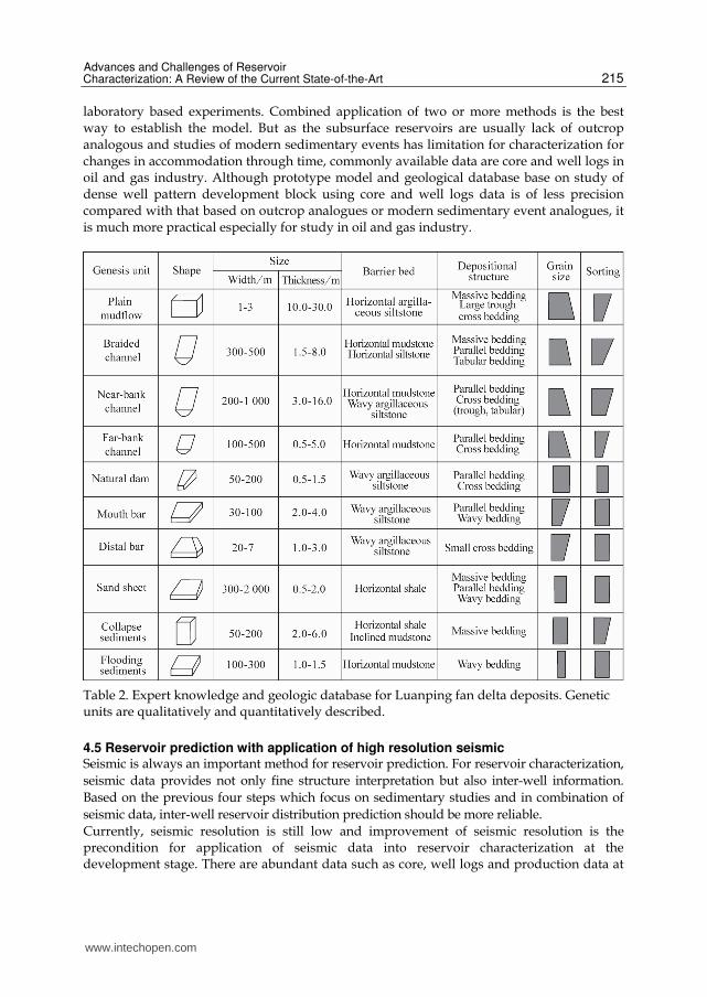
4.4 Establishment of prototype model and geological database The purpose to establish a prototype model and geological database is aimed to get parameters, such as sand geometry and scale (e.g. length, width, thickness and proportion) of genetic units and then provide quantitative references for inter-well sand prediction. Generally, seismic data is important for inter-well prediction, but it has limitation for low
www.intechopen.com

Earth Sciences
214
Fig. 3. Microfacies distribution of P I31 sub-layer in a block of Daqing oilfield, China
resolution (usually more than 5m in thickness). Predictions for thin sand and subdivision for thick sand are still difficult for seismic survey. The key technique solving this problem is to establish a reservoir prototype model and geological database. The so-called prototype model refers to the detailed model for outcrop analogue(s) which is geologically comparable to the system being studied, dense well pattern block in mature fields or the modern sedimentary event analogues. Establishment of reservoir prototype model and geological database is an important part for reservoir characterization. Quantitative characterization for sand can provide quantitative parameters for inter-well reservoir prediction and establishment of 3D reservoir model. The prototype model and geological database refers to parameters which quantitatively characterize the spatial distribution, boundary patterns and petrophysical properties of genetic units, and some qualitative sedimentary patterns. The database mainly includes lithologic/lithofacies knowledge, depositional environment and microfacies knowledge, sand geometry and diagenesis knowledge (Table 2) for a specific outcrop analogue. The primary prototype model should be study of the Gypsy profile sponsored by BP, which greatly enriches the geologic database of fluvial deposits (Doyle and Sweet, 1995). Similar study was also carried out in China on outcrop analogues in Datong and Luanping respectively. Qualitative description, quantitative measurement, sample analysis and well logs were conducted. Interior architecture of Luanping fan delta deposits and Datong braided channel deposits are thoroughly investigated. Therefore, prototype models and geological database for fan delta and braided channel deposits are established. Furthermore, in combination with stochastic modeling technique, methods for sand distribution prediction of this two kinds of deposits are developed (Jia and He, 2003). Methods for establishment of prototype model and geological databases include detailed outcrop analogue, dense well correlation, modern sedimentary event analogue and
www.intechopen.com
Advances and Challenges of Reservoir Characterization: A Review of the Current State-of-the-Art
215
laboratory based experiments. Combined application of two or more methods is the best way to establish the model. But as the subsurface reservoirs are usually lack of outcrop analogous and studies of modern sedimentary events has limitation for characterization for changes in accommodation through time, commonly available data are core and well logs in oil and gas industry. Although prototype model and geological database base on study of dense well pattern development block using core and well logs data is of less precision compared with that based on outcrop analogues or modern sedimentary event analogues, it is much more practical especially for study in oil and gas industry.
Table 2. Expert knowledge and geologic database for Luanping fan delta deposits. Genetic units are qualitatively and quantitatively described.
4.5 Reservoir prediction with application of high resolution seismic Seismic is always an important method for reservoir prediction. For reservoir characterization,
seismic data provides not only fine structure interpretation but also inter-well information.
Based on the previous four steps which focus on sedimentary studies and in combination of
seismic data, inter-well reservoir distribution prediction should be more reliable.
Currently, seismic resolution is still low and improvement of seismic resolution is the precondition for application of seismic data into reservoir characterization at the development stage. There are abundant data such as core, well logs and production data at
www.intechopen.com

Earth Sciences
216
the development stage which are advantages for development seismic. Therefore, seismic data processing and interpretation should incorporate existing data and geological knowledge as much as possible to improve its precision. Vertical Seismic Profiling (VSP) technique is an effective method used to distinguish small structure near wellbore, identify lithology and obtain fracture parameters. Combined with the seismic data interpretation, this technique can provide near wellbore petrophysical parameters for reservoir characterization. Time lapse seismic (4D) technique is specialized in dynamic monitoring through seismic responses changing with time. This technique plays an important role in remaining reserves identification in mature field (Mezghani et al., 2004). Inter-well seismic technique focus on reservoir lateral heterogeneity and provide inter-well peterophysical parameters for reservoir modeling (Justice et al., 2000). Applications of Inter-well seismic technique in the Daqing and Shengli oilfields shows that layers with 2~3m in thickness can be identified, sometime even to 1m, and small faults have a clear response (Figure 4).
Fig. 4. Application of inter-well seismic survey for reservoir prediction in some oilfield, China. The picture on the left shows the result of ineterwell seismic imaging and the right one is about interwell seismic interpretation. It illustrates that interwell reservoir heterogeneity can be investigated and small scale faults can be identified clearly.
4.6 Establishment of comprehensive reservoir architecture model Main tasks of reservoir characterization at different stage of field development vary a lot. At early stage of field development or at exploration stage, the priority for reservoir characterization should be investigation for reservoir architecture and characterization of reservoir heterogeneity. Whereas, at mature stage of field development, the key target for reservoir characterization should be focused on the reservoir compartments which are separated or laminated. Especially for water injection, separated or laminated reservoir compartments are usually not swept areas and hold most of the remaining reserves. Establishment of reservoir architecture model can further depict the interior features of genetic units and investigate separated or laminated reservoir compartment. Figure 5 shows a cross-section or correlation for a point bar reservoir architecture in a block of Daqing Oilfield, China.
www.intechopen.com

Advances and Challenges of Reservoir Characterization: A Review of the Current State-of-the-Art
217
Fig. 5. Cross-section profile for reservoir architecture of single channel sand in a block of Daqing Oilfield, China. Sand lateral accretion can be identified and subdivision of the single point bar into multiple lateral accretionary sands was initialized. It further reveals that genetic units inside reservoir architecture are separated or laminated.
In this step, reservoir architectural elements should be analyzed thoroughly. Miall et al. (1985) studied the subdivision of bounding surfaces inside reservoir architecture and proposed a full set of methods and theories about hierarchical order to the bounding surfaces. Hierarchical boundary analysis is from point view of system theory and studies the hierarchy and structure of the deposition system, highlighting isochronous and intermittent characteristics of the sedimentary process. Thus the hierarchical boundaries are compatible with the stratigraphy sequences and can be subdivided infinitely but always fitting the depositional genesis analysis. On this basis, reservoir architecture elements are widely studied for thoroughly investigation to the reservoir interior in China and aboard. Research on fluvial deposits is highly developed. In recent years, researchers from China have carried out a lot of research in this area. Jia and Cai (1992) and Zhang (1992) introduced their ideas and methods of reservoir architecture from different aspects. Although the terminology is different, their works have much similarity in conceptual system with reservoir architecture. Hierarchies of reservoir architecture were studied. Subdivision and identification methods for architecture elements were developed. Following researchers such as Yin et al. (2001; 2002), He et al. (2005a; 2005b) and Liao (2006) studied the delta depositional sands from point view of reservoir architecture. These works show that researches on reservoir architecture provides a sedimentary basis and a new approach to subdivision of architecture elements.
4.7 Evaluation of reservoir petrophysical properties and fluid distribution The previous six steps aim to establish reservoir framework model. However petrophysical properties and fluid distribution models should be integrated with reservoir framework model to obtain a comprehensive reservoir model. Methods of reservoir petrophysical properties characterization include quantitative description, influencing factor analysis, spatial distribution analysis, inter-well prediction and variation pattern analysis. Research in fluid distribution rules is defined as qualitative or quantitative descriptions for fluid types, properties and saturations. Currently, reservoir petrophysical properties are derived from laboratory-based core analysis and well logs. Reservoir fluid can be identified through seismic survey or sampling.
www.intechopen.com

Earth Sciences
218
Their spatial distribution predictions are reached through seismic interpretation or extrapolation of well data. It can be found that above works are based on static data without consideration of reservoir dynamic characteristics and suitable for oilfield at exploration stage or early stage of development. But for oilfield at the middle or mature stage of development, studies on reservoir petrophysical properties and fluid distribution are more complicated, especially for oilfield through long-term water flooding. Reservoir petrophysical properties change a lot with the advance of field development. Oil zone permeability, rock cementation, production rate, oil viscosity are control factors to petrophysical property changes. High permeable channel (large pores) gradually develops in highly flooded zone, causing ineffective water circulation and seriously affecting the displacement efficiency. Remaining reserves are still abundant in non-swept areas. Whereas water blockage will take place in low permeable zone which causes additional permeability reduction. Thus, reservoir characterization at the middle or mature stage of field development should take the changes of peterophysical properties into consideration, especially distribution of high permeable channel.
4.8 Establishment of comprehensive and integrated reservoir geological model A subsurface reservoir model is a computer based representation of petrophysical parameters such as porosity, permeability, fluid saturation, etc (Pringle et al., 2006). Through previous steps, various parameters needed have been well prepared. In this step, 3D subsurface reservoir model can be finally established with calibration of existing data and the key factor is the optimization of modeling method and integration of geologist’s expert knowledge. In the past two decades, different stochastic methods (pixel-based methods e.g. Gaussian-related stochastic models, object-based modeling methods e.g. Boolean models, and process-based methods) and deterministic methods have been developed for reservoir geological modeling (Hu, 2003).
5. Challenges and development trend of reservoir characterization technology
With everlasting high heterogeneity and diversity of reservoir rocks, characterization methods for reservoir framework, pore structure and petrophysical flow units are still great challenges. Today, there is still no substitute for high quality seismic interpretation which may reveal essential geological features and important heterogeneities. Seismic acquisition, processing and interpretation techniques have been refined steadily over the years. Methods e.g. Vertical Seismic Profiling (VSP), inter-well seismic, time lapse seismic (4D) technologies etc. have been calibrated with seismic processing and interpretation. But seismic technique is still short of resolution and can not effectively diagnose small-scale structures or architecture elements. Just as Haldorsen and Damsleth (1993) remarked: The industry wants 1-m resolution at typical North Sea reservoir depths before the turn of the century! Achieve a dramatic seismic resolution improvement should still be goal of the oil and gas industry. In other words, there are still challenges in seismic survey and methods to improve resolution will be one of development trends. Crosswell (or interwell) techniques have been developed in these years. Crosswell data were calibrated into reservoir models. Crosswell seismic imaging to provide images of reflectivity, velocity and formation properties by amplitude-versus-angle (AVA) inversion has been developed (Yu et al., 2008) and interwell seismic imaging was also developed for
www.intechopen.com

Advances and Challenges of Reservoir Characterization: A Review of the Current State-of-the-Art
219
hydraulic fracture monitoring (Bailey, 1973; Duncan and Eisner, 2010; Maxwell et al., 2010). Whereas, interwell petrophysical properties of reservoir geological model are still determined by extrapolation of adjacent well data or derived directly from seismic interpretation. But because of low resolution, petrophysical properties and hydrocarbon distribution derived from seismic data usually can not fulfill the need of development planning. Crosswell petrophysical properties and hydrocarbon distribution are still great challenges. As sustained recovery of oil or gas from porous media, reservoir petrophysical properties, pressure and fluid distribution are changing with time. With initialization and development of 4D seismic technology, methods to update petrophysical properties and fluid distribution of geological model have been highlighted. Whereas fluid distribution and petrophysical properties changes a lot and becomes more complicated through field development especially for oilfield through long-term water flooding. High permeable channel (large pores) gradually develops in highly flooded zone, causing ineffective water circulation and seriously affecting the displacement efficiency. Whereas water blockage will take place in low permeable zone which causes additional permeability reduction. Remaining reserves are still abundant in non-swept areas. History matching and 4D seismic are current methods to update reservoir geological model with advances of field development. Neither history matching nor 4D seismic methods can characterize the changes of reservoir petrophysical properties. Effective way to characterize petrophysical properties changes with field development should be challenge and one of emerging trends. In summary, challenges of reservoir characterization remain in three aspects: resolution to identify small scale reservoir compartments, e.g. fracture, small-scale structure and thin layers, which aim to establish a detailed reservoir framework; crosswell petrophysical properties and hydrocarbon prediction, which are basis for spatial distribution of reservoir properties; characteristics of physical property dynamic changes with advances of field development, which are very important to reservoir performance. Thus, in the author’s point of view, resolution improvement for seismic survey, effective methods to appropriately characterize crosswell petrophysical properties and hydrocarbon distribution and effective way to characterize dynamic changes of petrophysical properties should be three main development trends for reservoir characterization technology.
6. Conclusions
In this paper, discussions were carried out from four aspects and progresses of this work can be summarized as follows: (1) the words, e.g. advanced, practical, comprehensive, integrated, digital and detailed which are used to decorate the phase “reservoir characterization” , were discussed. Technique contents and features for each word (phase) were verified. (2) Three techniques have been selected and their advances have been reviewed. 4D seismic, digital data capture technology applied in outcrop study and microseismic monitoring can improved reservoir characterization from different aspects. Reservoir characterization with 4D seismic can characterize the dynamic of reservoir performance and remaining reserves can be evaluated. Digital data capture technology can be calibrated with outcrop study and it has advantages for obtaining more accurate and denser digital datasets from outcrop. Microseismic monitoring can effectively image the downhole fracture network deformation of hydraulic fracturing and capture dynamic changes of reservoir. (3) Practical procedures for reservoir characterization have been
www.intechopen.com

Earth Sciences
220
initiated. It is consist of eight steps. The technique feature and the main task were clearly defined. It is a hoped to be helpful to technical staffs or researchers. (4) Challenges and development trends were reviewed. Resolution improvement for seismic survey, effective methods to appropriately characterize crosswell petrophysical properties and hydrocarbon distribution and effective way to characterize dynamic changes of petrophysical properties should be three main development trends for reservoir characterization technology. Finally, as reservoir characterization is a comprehensive and highly integrated technology, it is important to state that the author has limited knowledge and if there is any mistake or something improper please feel free to point it out.
7. Acknowledgements
This work is supported by research funds from National Grand Research Project (No. 2011ZX05015) and Science & Technology Research Project of PetroChina (No. 2011B-15). The authors are extremely grateful to PetroChina Co. Ltd., for permission to publish this work.
8. References
Abbott, D., C. Neale, and J. D. Lakings, et al., 2007, Hydraulic fracture diagnostics in
theWilliams Fork Formation, Piceance basin, Colorado using surface microseismic
monitoring technology: Proceedings of the Rocky Mountain Oil & Gas Technology
Symposium, Society of Petroleum Engineers, Paper 108142.
Albright, J. N., and R. J. Hanold, 1976, Seismic mapping of hydraulic fractures made in
basement rocks: Proceedings of the Energy Research and Development
Administration (ERDA) Symposium on Enhanced Oil and GasRecovery, v. 2,
Paper C-8.
Bailey, J. R., 1973, Mapping of earth fractures induced by hydrofracturing: U. S. Patent 3
739 871.
Barker,W., 2009, Increased production through microseismic monitoring of hydraulic
fracturing over amultiwell program: Proceedings of the Annual Technical
Conference and Exhibition, Society of Petroleum Engineers, Paper 124877.
Bellian, J.A., C. Kerans, and D.C.Jennette, 2005, Digital outcrop models: application of
terrestrial scanning lidar technology in stratigraphic modeling: Journal of
Sedimentary Research, v. 75, no. 2, p. 166-176.
Breed, C.T., and T. Grow, 1979, Morphology and distribution of dunes in sand seas using
LANDSAT (ERTS) Imagery: In McKee, E.D. (Ed), A study of global sand seas.
United States Geological Survey (USGS) Professional Paper, 253-303.
Bryant, I.D., and S.S. Flint, 1993, Quantitative clastic reservoir geological modelling:
problems and perspectives In: Flint, S. & Bryant, I.D. (Eds) The geological
modelling of hydrocarbon reservoirs and outcrop analogues. International
Association of Sedimentologists Special Publication, 15, 3-20.
Buckley, S.J. J.A. Howell, and H.D. Enge et al., 2008, Terrestrial laser scanning in geology:
data acquisition, processing and accuracy considerations: Journal of the Geological
Society, v.165, no. 3, p. 625-638. DOI: 10.1144/0016-76492007-100.
www.intechopen.com

Advances and Challenges of Reservoir Characterization: A Review of the Current State-of-the-Art
221
Castillo, J.J., M. Sanchez, and M.Rodriguez, et al., 1998, Integrated reservoir characterization
and volumetric analysis of the analysis of the Arecuna field (3D seismic area)
Orinoco belt: presentation at the 7th UNITAR Conference on Heavy Crude and Tar
Sands.
Chambers, K., S. Brandsberg-Dahl, and J.M. Kendall, et al., 2008, Testing the ability of
surface arrays to locate microseismicity: 78th Annual International Meeting, SEG,
ExpandedAbstracts, 1436–1440.
Chambers, K., O. Barkved, and J.-M.Kendall, 2009a, Imaging microseismic activity using the
LoFS permanent sensor surface array: 79th Annual International Meeting, SEG,
Expanded Abstracts, 1612–1616.
Chambers, K., J.-M., Kendall, and S. Brandsberg-Dahl, et al., 2009b, The detectability of
microseismic events using surface arrays: Workshop on Passive Seismic,
EAGE, A25.
Chapin, M.A., S. Davies, and J.L. Gibson, et al., 1994, Reservoir architecture of turbidite
sheet sandstones in laterally extensive outcrops, Ross Formation, Western Ireland:
In GCSSEPM 15th Annual Research Conference Proceedings, Submarine Fans and
Turbidite Systems., 53-68.
Clark, J.D., and K.T. Pickering, 1996, Submarine channels, processes and architecture: Vallis
Press.
Collinson, J.D., 1970, Deep channels, massive beds and turbidite current genesis in the
central Pennine Basin: Proceedings of the Yorkshire Geological Society. 37,
495-520.
Doss, S.K., S., Ezzedine and R.J. Gelinas et al., 2001, Forward-inverse adaptive techniques for
reservoir characterization and simulation: Theory and applications: Proceedings of
the 2001 SPE Annual Technical Conference and Exhibition, Society of Petroleum
Engineering, Paper 71600.
Doyle, J. D., and M. L. Sweet, 1995, Three-dimensional distribution of lithofacies, bounding
surfaces, porosity, and permeability in fluvial sandstone; Gypsy Sandstone of
northern Oklahoma: AAPG Bulletin, v. 79, p. 70-96.
Dreyer, T., L. Falt, and T. H. Knarud, et al., 1993, Sedimentary Architecture of Field
Analogues for Reservoir Information (SAFARI): a case study of the fluvial Escanilla
Formation, Spanish Pyrenees. In: S.S. Flint, and I.D. Bryant (Eds), The Geological
Modelling of Hydrocarbon Reservoirs and Outcrop Analogues International
Association of Sedimentologists Special Publication. London, 15, 57-79.
Duncan, P.M., and L. Eisner, 2010, Reservoir characterization using surface microseismic
monitoring: Geophysics, v.75, no. 5, 139-146.
Fageraas, B., P. Behn and J. Tessman et al., 2003, Comprehensive reservoir characterization
“From inside and out” using high-fidelity coupling techniques and point receivers:
Proceeding of the 2003 Offshore Technology Conference. OTC Paper 15073.
Floris, F.J.T. and M.R.H.E. Peersmann, 2002, Integrated scenario and probabilistic analysis
for asset decision support. Petroleum Geoscience, 8, 1-6.
Gibowicz, S. J., and A. Kijko, 1994, An introduction to mining seismology: Academic Press
Inc.
Glennie, K.W., 1970, Desert sedimentary environments: Elsevier Co., Amsterdam.
www.intechopen.com

Earth Sciences
222
Haldorsen, H.H. and E. Damsleth, 1993, Challenges in reservoir characterization:
Geohorizons, v. 77, no. 4, p. 541-551.
Hall, M., and J. Kilpatrick, 2009, Surface microseismic monitoring of slick water and
nitrogen fracture stimulations, Arkoma basin, Oklahoma: 79th Annual
International Meeting, SEG, Expanded Abstracts, 1562–1565.
He W., Wu S., Tang Y., et al., 2005a, The architecture analysis of the underground point
bar—taking Gudao Oilfield as an example. Journal of Mineralogy and Petrology,
25(2): 81-86.
He W., Wu S., Tang Y., et al., 2005b, Detailed architecture analysis of debouch bar in
Shengtuo oilfield, Jiyang Depression. Petroleum Exploration and Development,
32(5): 42-46.
Hu L.Y., 2003, History matching of object-based stochastic reservoir models: Proceeding of
the SPE 13th Middle East Oil Show & Conference, Society of Petroleum
Engineering, Paper 81503.
Jackson, M.D., S. Yoshida, A.H. Muggeridge et al., 2005, Three-dimensional reservoir
characterization and flow simulation of heterolithic tidal sandstones; AAPG
Bulletin, v. 89, no. 4, p. 507-528.
Jahns, H.O., 1966, A rapid method for obtaining a two-dimensional reservoir description
from well pressure response data: SPE Journal, 6(4), 315-327.
Jia Z, and Cai Z., 1992, Research methods of architecture: Geological Science and
Technology Information, 11(4): 63-68.
Jia A., He D., He W., et al., 2003, Application of outcrop geological knowledge database to
prediction of inter-well reservoir in oilfield. Acta Petrolei Sinica, 24(6): 51-53.
Jia A., and Cheng L., 2010, The technique of digital detailed reservoir characterization:
Petroleum Exploration and Development, v. 37, no. 6, p. 709-715.
Johnston, D., 2004, Reservoir characterization improves stimulation, completion practices:
Oil & Gas Journal, 102(4), p. 60-63.
Justice J H, Woerpel J C, Watts G P, et al., 2000, Interwell seismic data for reservoir
characterization: Proceeding of SPE Permian Basin Oil and Gas Recovery
Conference, Society of Petroleum Engineering, Paper 59695.
Keller, W. R., B. J. Hulsey, and P. M. Duncan, 2009, Correlation of surface microseismic
event distribution to water production and faults mapped on 3D seismic data: A
West Texas case study: 79th Annual International Meeting, SEG, Expanded
Abstracts, 1524–1526.
Kochnev, I. V., V. S. Polyakov, and I. Murtayev, et al., 2007, Imaging hydraulic fracture
zones from surface passive microseismic data: First Break, 25, 77–80.
Kovacic, L., and E. Poggiagliomi, 2003, Integrated time-lapse reservoir monitoring and
characterization of Cervia field: a case study: Petroleum Geoscience, v. 9. p.
43-52.
Kuznetsov, O. L., L. N. Chirkina, and G. A. Belova, et al., 2006, Seismic location of emission
centers-A new technology for monitoring the production of hydrocarbons: 68th
Conference & Technical Exhibition, EAGE, Extended Abstracts, B018
(in Russian).
www.intechopen.com

Advances and Challenges of Reservoir Characterization: A Review of the Current State-of-the-Art
223
Liao G., 2006, Analysis on sedimentology system and reservoir architecture of delta-shallow
lake facies of Fanzhuang in Jinhu depression. Journal of Southwest Petroleum
Institute, 28(2): 4-7.
Maxwell, S.C., J. Rutledge, and R. Jones, et al., 2010, Petroleum reservoir characterization
using downhole mircroseismic monitoring., Geophysics, v. 75, no. 5, p.
129-137.
McCaffrey, K.J.W., R.R. Jobnes, R.E. and Holdsworth, et al., 2005, Unlocking the spatial
dimension: digital technologies and the future of geoscience fieldwork: Journal of
the GeologicalSociety of London 162, 1-12.
Mezghani M., A. Fornel, and V. Langlais, et al. 2004, History matching and quantitative use
of 4D seismic data for an improved reservoir characterization: Proceedings of SPE
Annual Technical Conference and Exhibition, Society of Petroleum Engineering,
Paper 90420.
Miall A D., 1985, Architectural-element analysis: A new method of facies analysis applied to
fluvial deposits: Earth Science Review, 22(2): 261-308.
Montgomery, S.L., and M.F. Morea, 2001, Antelope shale (Monterey Formation), Buena
Vista Hills field: Advanced reservoir characterization to evaluate CO2 injection for
enhanced oil recovery: AAPG Bulletin, v. 85, no.4, p. 561-585.
Phillips, C., 1996, Enhanced thermal recovery and reservoir characterization: AAPG Pacific
Section-Old Oil Fields and New Life: A Visit to the Giants of the Los Angeles Basin,
p. 65-82.
Pringle, J.K., J.A. Howell and D. Hodgetts et al., 2006, Virtual outcrop models of petroleum
reservoir analogues: a review of the current state-of-the-art: First break, v. 24, p.
33-42.
Refae, A.T., S. Khalil, and B. Vincent et al., 2008, Increasing bandwidth for reservoir
characterization with single-sensor seismic data: a case study from Libya’s
challenging Lehib field. Petroleum Africa, 41-44.
Reynolds, A.D., 1999, Dimensions of Paralic Sandstone Bodies. AAPG Bulletin, v. 83, no. 2,
p. 211-229.
Robein, C. E., F. Drapeau, and D. L. Maurel, et al., 2009, Multi-network microseismic
monitoring of fracturing jobs-Neuquen TGR application: 71st Conference &
Technical Exhibition, EAGE, Extended Abstracts, X009.
Schisselé, E., and J. Meunier, 2009, Detection ofmicro-seismic events using a surface receiver
network:Workshop on Passive Seismic, EAGE, A12.
Slatt, R., and S. Mark, 2002, Practical reservoir characterization for the independent operator,
computer technology for comprehensive reservoir characterization: Petroleum
Technology Transfer Council, 512-514.
Wang J., 2008, Greeting the great development of theories and applications of reservoir
modeling: Earth Science Frontiers, 15(1): 16-25.
Yin T., Zhang C., Tang J., et al., 2001, Analysis on reservoir hierarchical structure in
Machang Oilfield: Journal of Jianghan Petroleum Institute, 23(4): 19-21.
Yin T., Zhang C., Fan Z., et al., 2002, Establishment of the prediction models of reservoir
architectural elements: Journal of Xi’an Petroleum Institute(Natural Science
Edition), 17(3): 7-10, 14.
www.intechopen.com

Earth Sciences
224
Yu G., B. Marion, and B. Bryans et al., 2008, Crosswell seismic imaging for deep gas
reservoir characterization: Geophysics, v. 73, no. 6, p.117–126, DOI:
10.1190/1.2980417
Zhang C., 1992, Hierarchy analysis in reservoir researches: Oil & Gas Geology, 13(3): 344-
350.
www.intechopen.com

Earth SciencesEdited by Dr. Imran Ahmad Dar
ISBN 978-953-307-861-8Hard cover, 648 pagesPublisher InTechPublished online 03, February, 2012Published in print edition February, 2012
InTech EuropeUniversity Campus STeP Ri Slavka Krautzeka 83/A 51000 Rijeka, Croatia Phone: +385 (51) 770 447 Fax: +385 (51) 686 166www.intechopen.com
InTech ChinaUnit 405, Office Block, Hotel Equatorial Shanghai No.65, Yan An Road (West), Shanghai, 200040, China
Phone: +86-21-62489820 Fax: +86-21-62489821
The studies of Earth's history and of the physical and chemical properties of the substances that make up ourplanet, are of great significance to our understanding both of its past and its future. The geological and otherenvironmental processes on Earth and the composition of the planet are of vital importance in locating andharnessing its resources. This book is primarily written for research scholars, geologists, civil engineers,mining engineers, and environmentalists. Hopefully the text will be used by students, and it will continue to beof value to them throughout their subsequent professional and research careers. This does not mean to inferthat the book was written solely or mainly with the student in mind. Indeed from the point of view of theresearcher in Earth and Environmental Science it could be argued that this text contains more detail than hewill require in his initial studies or research.
How to referenceIn order to correctly reference this scholarly work, feel free to copy and paste the following:
Ailin Jia, Dongbo He and Chengye Jia (2012). Advances and Challenges of Reservoir Characterization: AReview of the Current State-of-the-Art, Earth Sciences, Dr. Imran Ahmad Dar (Ed.), ISBN: 978-953-307-861-8,InTech, Available from: http://www.intechopen.com/books/earth-sciences/advances-and-challenges-of-reservoir-characterization-a-review-of-the-current-state-of-the-art