adopted by the urban transport committee …
TRANSCRIPT

ADOPTED BY THE URBAN TRANSPORT COMMITTEE FEBRUARY 2014
GOTHENBURG 2035 TRANSPORT STRATEGY FOR A CLOSE-KNIT CITY

GOTHENBURG 2035 TRANSPORT STRATEGY FOR A CLOSE-KNIT CITY
Adopted by the Urban Transport Committee on February 6, 2014
Urban Transport Administration, reg. no. 0894/11 ISSN 1103-1530
Commissioned by the City Executive Board, Gothenburg
Project managers Sofia Hellberg, Urban Transport Administration
Per Bergström Jonsson, Urban Transport Administration
Steering group Birgitta Hellgren (Chair), Urban Transport Administration
Jan Rinman, Urban Transport Administration Suzanne Andersson, Urban Transport Administration
Principal authors Sofia Hellberg, Urban Transport Administration
Per Bergström Jonsson, Urban Transport Administration Magnus Jäderberg, Urban Transport Administration Malin Sunnemar, Urban Transport Administration
Hans Arby, consultant
Working group membersUrban Transport Administration
Anna Boberg, Björn Carlsson, Max Falk, Nina Galligani, Johan Jerling, Frida Karlge, Anders Roth, Dharmesh Shah,
Daniel Sjölund, Magnus Ståhl, Ma-Lou Wihlborg
Property Management Administration Staffan Claesson, Lisa Häggdahl, Lukas Memborn
City Planning Office Sara Brunnkvist, Annelie Kjellberg, Anna Noring, Björn Siesjö
Västra Götaland RegionJörn Engström
Västtrafik Magnus Lorentzon
Swedish Transport AdministrationKerstin Boström
Consultants Bo Asplind, Peter Blomquist, Anna Lundqvist,
Staffan Sandberg, Stephan Schumpp, John Wedel
Consultancy support Arby Kommunikation, Carl-Johan Engström, Futuramb,
Lillemor Bulukin, Ramböll, Sweco, Trivector, Tyréns, WSP, ÅF
Graphic design and productionTre Art AB

TRANSPORT STRATEGY FOR A CLOSE-KNIT CITY – 3
FOREWORD These are exciting times in Gothenburg. Planning for a series of major infrastructure projects is now at an advanced stage and the RiverCity Vision provides a totally new way of viewing our city. It is estimated that by 2035 Gothenburg will have 150,000 more residents and 80,000 more jobs, and the city will be the core of a labour market region with 1.7 million inhabitants. This will produce numerous challenges but at the same time an invaluable opportunity to create a cohesive city that lives up to ambitious environmental objectives – an opportunity not available to every city.
Traffic and road users are an integral part of an attractive city and a successful economy. The goals and direction outlined in the Transport Strategy are aimed at making everyday life simpler in a large, competitive, close-knit city. The Transport Strategy will be implemented in action and investment plans, and will be the starting point for present and future plans and programmes for different road-user categories and areas of responsibility.
Work on the Transport Strategy has been in progress since it was first commissioned by the City Executive Board in autumn 2011. It has comprised a number of sub-projects, resulting in reports that subsequently formed the basis of the provisional draft that was circulated for comments in March 2013. The Strategy was well received, and the comments that were presented helped us to make the final version of the Transport Strategy even clearer.
Support from the administrations, politicians and other parties and stakeholders who were affected has been secured gradually as the work progressed. This was achieved through dialogue, workshops and presentations. Political support for the Strategy has been built up incrementally. The Urban Transport Committee has received briefings on an ongoing basis throughout the process and the City Executive Board has been briefed on two occasions.
The Transport Strategy has been developed in parallel with the Development Planning Strategy and the Green Strategy and is based, as they are, on the Comprehensive Plan adopted in 2009, which is the overall policy document for land use in the city. Close collaboration between the four specialist urban planning administrations – the Urban Transport Administration with overall responsibility for the Transport Strategy, the City Planning Office and the Property Management Administration with overall responsibility for the Development Planning Strategy, and the Park and Landscape Administration with responsibility for the Green Strategy – has led to highly favourable conditions for the successful implementation of the strategies and plans.
Together with the adopted RiverCity Vision, the three strategic documents point out a clear direction for land use in Gothenburg over the next 20 years. They provide inhabitants, businesses and other stakeholders with the opportunity to make their own long-term decisions, all pointing in the same direction. The result will be a large, close-knit city with successful businesses, environmental qualities, a vibrant urban landscape and a simpler everyday life.
Gothenburg, December 18, 2013
Birgitta Hellgren Stefan Eglinger Director General – 2013 Director General 2014 –

Foto
: Han
s A
rby

SUMMARY
TRANSPORT STRATEGY FOR A CLOSE-KNIT CITY – 5
SUMMARYGothenburg is in the process of going from being a small city to a large city. In order to be in a position to welcome more inhabitants, visitors and businesses in a denser city, and to do so sustainably, the transport system needs to change. The people of Gothenburg must be able and want to walk, cycle and use public transport as their preferred means of getting around the city. The current planning concept, ’access through rapid mobility’ has been complemented with ’access through short distances’.
Gothenburg can increase its attractiveness to people and businesses by offering a fuller urban life and by developing the port and other logistics and industry activities even further as long as this does not impact negatively on the local environment. Managing more people’s travel needs and strengthening the city’s competitiveness are, alongside reducing the climate impact of the transport sector, the three main challenges that need to be addressed in the Transport Strategy.
The Transport Strategy is the governing document for how the transport system and streetscape in Gothenburg are to be developed in order to achieve set objectives and meet the challenges facing the city.
THE TRANSPORT STRATEGY HIGHLIGHTS THREE MAIN OBJECTIVES… The Transport Strategy focuses on three areas – travel, urban space and transport of goods – which are highly significant if Gothenburg is to achieve the objectives that have been laid down and generate quality of life, competitiveness and sustainable development.
Travel – how to create an easily accessible regional centre where it is easy to reach key places and functions irrespective of the mode of transport and other conditions.
Urban space – how to contribute to more attractive city environments where people want to live, work, shop, study and meet.
Transport of goods – how to contribute to consolidating Gothenburg’s position as the logistics centre of Scandinavia, where both new and existing industries can develop and create job opportunities without encroaching on quality of life, sustainability and accessibility.
The three main objectives in the strategy – an easily accessible regional centre, attractive urban environments and Scandinavia’s logistics centre – are a response to the 13 strategic questions in the Comprehensive Plan for Gothenburg. The three main objectives are also highly relevant to Gothenburg’s role as a hub and as a driving force for the entire region.
… AND A NUMBER OF IMPLEMENTATION PRINCIPLES The Transport Strategy also lays down four principles and a number of success factors for its implementation.

6 – TRANSPORT STRATEGY FOR A CLOSE-KNIT CITY
TRAVEL STRATEGYWe will make it easy to reach key places and functions in Gothenburg by:
Strengthening the potential to travel to, from and between the city’s cores and key destinations (structure) A structure based on the city’s cores makes it possible to offer rapid, reliable, high-capacity public transport and a high-quality cycling network that is easily accessible from anywhere in the city. At the same time, the structure supports the development of designated nodes into areas of a dense, mixed-use character.
Increasing access to neighbourhood services, retail outlets, meeting places and other everyday functions (community planning)Making it easier to manage everyday tasks at home or in the neighbourhood will reduce the need for travel or make long journeys, while at the same time it will create a safer and livelier neighbourhood. The most important contribution that transport planning makes in this context is the prioritisation of pedestrians and cyclists in the local environment.
Making more efficient use of roads and streets (use) Information and control and management of road traffic in combination with measures to limit the number of vehicles in the transport system will ensure good accessibility for all road users and goods transport.
URBAN SPACE STRATEGYWe will create attractive urban environments and a vibrant city life in Gothenburg by:
Prioritising pedestrians and cyclists and adapting speeds mainly to pedestrians (movement) Adapting streetscapes and speeds in the first instance to pedestrians and in the second instance to the needs and conditions of cyclists will lay the foundation for safe, secure, lively streets, without excluding other types of road user.
Rearranging the streetscape to create more space where people want to be and where they can move around (space)Space is a limited resource in city environments. Reallocating space between types of traffic and between traffic and the people within the area pursuing different activities will create conditions for attractive, lively and thus safer urban spaces. Parking should primarily be in multi-storey car parks and garages, and goods distribution should take place mainly at times when it disturbs as few people as possible.
Creating a denser and more interconnected network of streets without barriers (structure)Navigability, route efficiency and the absence of barriers in the street network make it easier to move around, thus consolidating the city and spreading urban life to more places. The dense and interconnected street network exists for all modes of transport, as long as flows and speeds do not create new barriers.
Travel 2011 Effect targets 2035

SUMMARY
TRANSPORT STRATEGY FOR A CLOSE-KNIT CITY – 7
GOODS TRANSPORT STRATEGYWe will work in collaboration with other bodies to make Gothenburg a world leader in efficient, climate-smart handling of goods. This will be achieved by:
Ensuring good accessibility for goods transport in Gothenburg while at the same time reducing negative local environmental effectsIncreased rail network capacity and prioritisation of freight traffic on designated routes not only improves accessibility for goods but also allows effective measures to be implemented to reduce the effects of noise, emissions and barriers. Optimising the choice of transport and the use of combined transport increase efficiency and reduce climate impact.
Collaborating regionally in the establishment of logistics centres and transport-intensive operations By including goods transport in the urban planning process and applying a regional perspective to the establishment of transport-intensive operations, industry, retailing and logistics can be developed and conflicts between goals can be avoided.
Stimulating innovation in collaboration with academic institutions and businessesAn innovation platform for the city creates clarity and coordination in relation to other parties. Networks and other platforms for dialogue with businesses and public activities generate the conditions required for joint solutions and more rapid implementation. Networks are needed at both the strategic and operative levels.
IMPLEMENTATION PRINCIPLESBegin with investments that facilitate travel within, through or around the inner city
Ensure that accessibility is maintained while the close-knit city is being realised
Support innovation and the introduction of new solutions, and allow Gothenburg to be a testing ground
Make use of the potential in a meaningful dialogue with businesses and inhabitants

Pho
to: i
Sto
ck P
hoto

TRANSPORT STRATEGY FOR A CLOSE-KNIT CITY – 9
INNEHÅLL
1 WHAT IS GOTHENBURG’S TRANSPORT STRATEGY? ................................. 12 Why a transport strategy is needed .....................................13
The transport strategy in context ........................................13
What the transport strategy is not .......................................17
Further reading .....................................................................17
2 CHALLENGES ................................................... 20 Global challenges .................................................................21
National challenges ..............................................................21
Regional challenges..............................................................22
Local challenges ...................................................................23
3 OBJECTIVES AND STRATEGIES ....................... 29 Objectives .............................................................................29
Travel strategy ......................................................................32
Urban space strategy ............................................................44
Goods transport strategy .....................................................54
4 PRINCIPLES AND SUCCESS FACTORS ............ 64 Implementation principles ....................................................64
Success factors for achieving the objectives ......................67

Pho
to: V
GR

CHAPTER 1WHAT IS GOTHENBURG’S
TRANSPORT STRATEGY
WHAT IS GOTHENBURG’S TRANSPORT STRATEGY
1
12 – TRANSPORT STRATEGY FOR A CLOSE-KNIT CITY
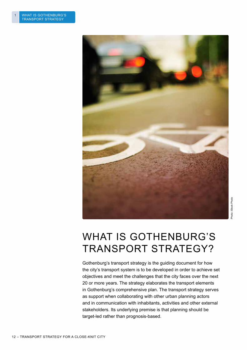
WHAT IS GOTHENBURG’S TRANSPORT STRATEGY?Gothenburg’s transport strategy is the guiding document for how the city’s transport system is to be developed in order to achieve set objectives and meet the challenges that the city faces over the next 20 or more years. The strategy elaborates the transport elements in Gothenburg’s comprehensive plan. The transport strategy serves as support when collaborating with other urban planning actors and in communication with inhabitants, activities and other external stakeholders. Its underlying premise is that planning should be target-led rather than prognosis-based.
Pho
to: i
Sto
ck P
hoto

WHAT IS GOTHENBURG’S TRANSPORT STRATEGY
1
TRANSPORT STRATEGY FOR A CLOSE-KNIT CITY – 13
WHY A TRANSPORT STRATEGY IS NEEDEDGothenburg is going from being a small city to being a large city with more residents, workers and visitors, with a strengthened role as the logistics centre of Scandinavia and with a vigorous industrial sector. These are favourable developments for Gothenburg and the region – but they must be both supported and managed in the right way.
Reducing the climate impact of the transport sector, giving more people better travel possibilities, and strengthening competitiveness by offering a vibrant urban life and good business conditions are three of the challenges that the transport strategy takes on.
A strategy is about what priorities to make in order to achieve set objectives. The transport strategy states the city’s overall focus for planning and decisions on investments and other measures – particularly in the area of transport, but also for things that need to be done by other urban planning actors. The transport strategy is the basis for current and future work to draw up programmes and plans for different types of road user and areas of responsibility, as well as for guidelines and processes in daily activities.
The transport strategy and its objectives set their sights on 2035. Twenty years is a relatively short time from an infrastructure perspective, which means that many big and small decisions pointing in the right direction must be made already over the next few years.
THE TRANSPORT STRATEGY IN CONTEXTThe transport strategy sets out from a number of politically adopted policy documents at the national, regional and local levels. The transport strategy must be an integral part of the municipality’s other objectives and strategy efforts and can also contribute to the development of the transport system in Sweden as a whole.
Urban planning needs to be undertaken from a holistic perspective, where transport is a means to achieving a functioning and attractive city. The transport strategy has therefore been developed in an integrated process with the Development Planning Strategy and the green strategy. Together, these documents constitute an important part of the strategic planning for the city’s land use, with the aim of specifying the objectives and strategies of the comprehensive plan.
Comprehensiveplan
Local environmentalquality objectives
… Cyc
le p
rogr
amm
e
… Xx
plan
Xx
prog
ram
me
Transport policyobjectives
GothenburgRegion Associationof Local Authorities(GR) Sustainablegrowth
The River CityVision
K2020
Regional transportprovisionprogramme forVGR
Other policydocuments
Transportstrategy
DevelopmentPlanning Strategy Green strategy
Roa
d sa
fety
prog
ram
me
The three parallel commissions set out from comprehensive policy documents, principally the comprehensive plan and local environmental quality objectives. Other policy documents that influence the transport strategy include transport policy objectives and the structural projection for the Gothenburg region. The transport strategy will then lead to a number of plans, of which e.g. the bicycle programme is in progress and a road safety programme is ready.
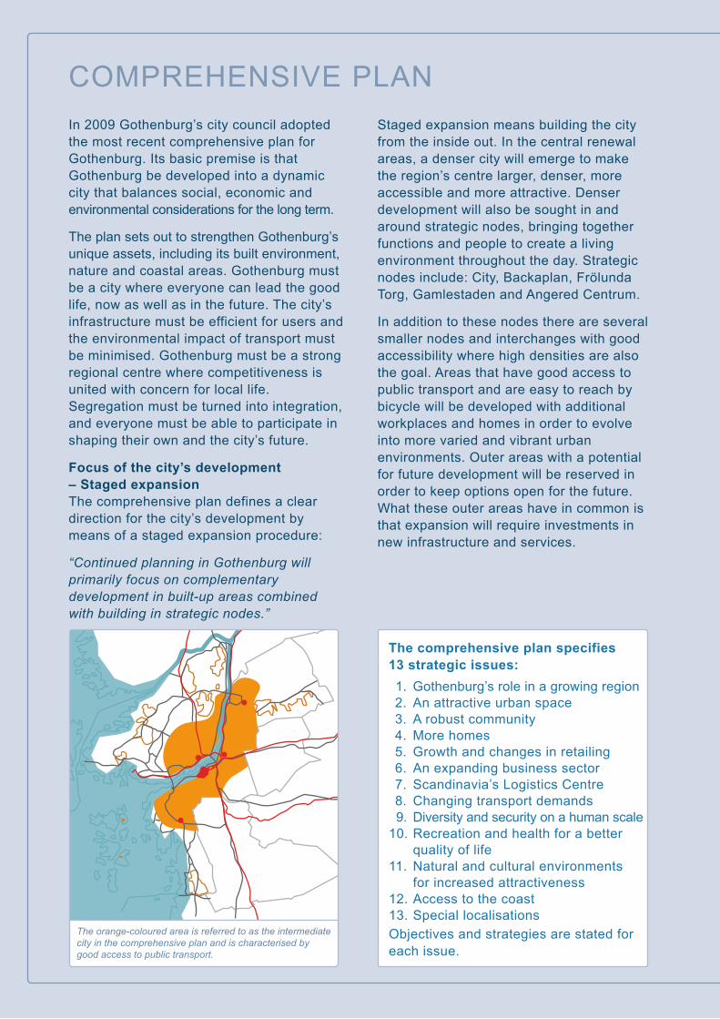
COMPREHENSIVE PLANIn 2009 Gothenburg’s city council adopted the most recent comprehensive plan for Gothenburg. Its basic premise is that Gothenburg be developed into a dynamic city that balances social, economic and environmental considerations for the long term.
The plan sets out to strengthen Gothenburg’s unique assets, including its built environment, nature and coastal areas. Gothenburg must be a city where everyone can lead the good life, now as well as in the future. The city’s infrastructure must be efficient for users and the environmental impact of transport must be minimised. Gothenburg must be a strong regional centre where competitiveness is united with concern for local life. Segregation must be turned into integration, and everyone must be able to participate in shaping their own and the city’s future.
Focus of the city’s development – Staged expansionThe comprehensive plan defines a clear direction for the city’s development by means of a staged expansion procedure:
“Continued planning in Gothenburg will primarily focus on complementary development in built-up areas combined with building in strategic nodes.”
Staged expansion means building the city from the inside out. In the central renewal areas, a denser city will emerge to make the region’s centre larger, denser, more accessible and more attractive. Denser development will also be sought in and around strategic nodes, bringing together functions and people to create a living environment throughout the day. Strategic nodes include: City, Backaplan, Frölunda Torg, Gamlestaden and Angered Centrum.
In addition to these nodes there are several smaller nodes and interchanges with good accessibility where high densities are also the goal. Areas that have good access to public transport and are easy to reach by bicycle will be developed with additional workplaces and homes in order to evolve into more varied and vibrant urban environments. Outer areas with a potential for future development will be reserved in order to keep options open for the future. What these outer areas have in common is that expansion will require investments in new infrastructure and services.
The orange-coloured area is referred to as the intermediate city in the comprehensive plan and is characterised by good access to public transport.
The comprehensive plan specifies 13 strategic issues: 1. Gothenburg’s role in a growing region 2. An attractive urban space 3. A robust community 4. More homes 5. Growth and changes in retailing 6. An expanding business sector 7. Scandinavia’s Logistics Centre 8. Changing transport demands 9. Diversity and security on a human scale 10. Recreation and health for a better quality of life 11. Natural and cultural environments for increased attractiveness 12. Access to the coast 13. Special localisationsObjectives and strategies are stated for each issue.

A SIMPLER EVERYDAY LIFE FOR LARGER NUMBERS OF PEOPLEGothenburg’s urban planning has 2035 in its sights
In order for Gothenburg to continue developing into an attractive and sustainable city, coordinated land planning is required. The city has therefore drawn up four strategic documents which together set out the course for how Gothenburg is to become a city that offers a simpler everyday life for larger numbers of people in a green and vibrant city.
The strategies’ common planning horizon is 2035. It is estimated that Gothenburg will at that point have 150,000 more residents and 80,000 more jobs than today, and that the city will be at the core of a labour market region of more than 1.75 million inhabitants. The comprehensive plan that was adopted in 2009 and is the overall policy document for the city’s land use serves as the common starting point.
The Development Planning Strategy 2035 indicates which locations have particularly good conditions for sustainable urban development, in which more inhabitants live close to the supermarket, the school, the bus stop – all the things that make everyday life a little easier. This will be achieved by making the already built environment denser through new construction.
The River City Vision specifies in what way and with what qualities the central development areas in Gothenburg will be built. The River City will be open to the world. It will be inclusive, green and dynamic. It will be designed to bring the city together, access the water and strengthen the regional core.
The transport strategy for a close-knit city indicates how the transport system needs to be developed as more people live, work, shop, study and meet in the city. It will be easy to get to where you are going in Gothenburg, the urban environment will be
seen as attractive and will contribute to a vibrant urban life, and Gothenburg will be a world leader in efficient and climate-smart handling of goods.
The green strategy for a dense and green city indicates how Gothenburg can remain and develop further as a city with considerable green qualities, from both a social and an ecological perspective, while at the same time being made more dense through new construction. It points to the qualities that will characterise the future, dense and green Gothenburg, and how we need to work in order to achieve them.
The city needs to be clear about how Gothenburg is to develop. This gives inhabitants, businesses and other stakeholders a chance of to make their own long-term decisions that point in the same direction – for an attractive, sustainable and competitive city. The strategies provide support to the city’s politicians and officials when making priorities by showing where new construction will make the biggest difference by creating the conditions for a “simpler everyday life for larger numbers of people”.

WHAT IS GOTHENBURG’S TRANSPORT STRATEGY
1
16 – TRANSPORT STRATEGY FOR A CLOSE-KNIT CITY
Comprehensive policy documentGothenburg’s comprehensive plan from 2009 describes the target scenario for the city as laid down in policy. Gothenburg is to develop into a dynamic city that balances social, economic and environmental considerations for the long term. The city’s infrastructure will be efficient for users and the environmental impact of transport will be minimised. The gist of the comprehensive plan is fully in accordance with the ideas behind the Gothenburg Region’s objectives and strategies. Gothenburg City Council has adopted twelve local environmental quality objectives on the basis of the 16 national environmental quality objectives. Of these it is principally Reduced Climate Impact, Clean Air and A Good Built Environment that have implications for the transport sector.
Other policy documentsThe overarching objective of Swedish transport policy (Govt. bill 2008/09:93) is to “ensure a socioeconomically efficient provision of transport, sustainable for the long term, for citizens and businesses throughout the country”. The overarching objective is supported by a functional objective and a consideration objective.
At the regional level, the Gothenburg Region Association of Local Authorities (GR) has adopted a goal and strategy document, Sustainable Growth (a 2013 update of the Durable Growth document from 2006), which includes targets for population growth, improved qualities, a regional structure sustainable for the long term and an infrastructure sustainable for the long term. The adjoining image from the Structural Projection for the region (2008) shows the unified view among the member municipalities on how the regional structure is to be developed.
A vision and a strategy, the River City Vision, have been developed for the extensive area of central Gothenburg that is part of the renewal area indicated in the comprehensive plan. The vision provides an image of how the city will develop: it will be accessible to all irrespective of background, it will be shaped by encounters of different kinds and it will be connected across the river. The image of how the city is to develop can be summarised in three strategies: Bring the city together. Access the water. Strengthen the core.
Over the past few years many decisions have been made which affect ongoing planning. The most comprehensive of these is the West Sweden Agreement, which includes the West Link rail tunnel. The agreement also includes a decision on co-financing via a congestion tax which has been levied in Gothenburg since 1 January 2013. An important objective of the West Sweden Agreement is to strengthen public transport to the regional centre.
Under the new public transport act, which came into force on 1 January 2012, all public transport authorities must draw up a transport provision programme. The regional transport provision programme for West Götaland details the long term targets for public transport in the region. The overarching goal is to increase the market share of public transport for an attractive and competitive region. Today one in four motorised journeys in the region is by public transport. The target for 2025 is one in three journeys. Achieving that target will require a doubling of public transport use.
Gothenburg City is also in the process of formulating a Climate strategy programme intended to be adopted by the City Council during the autumn of 2014. There is also an Environment programme for Gothenburg (2013).
The structure is made up of the core, the metropolitan area, the main corridors, the coastal zone, the green belts and Göta River.
GR’S STRUCTURAL PROJECTION
THE RIVER CITY
THE SOUTHBANK
KVILLESTAN
FRIHAMNEN
LINDHOLMEN
THE CENTRALSTATION AREA
RINGÖN
GULLBERGSVASSGÖTARIVER
BRIDGE
BACKAPLAN
2015BEFORE
2030BEFORE
2020BEFORE
2025BEFORE
2030AFTER
According to the vision, the River City will grow from the nodes, the corridors and from a living waterfront. By allowing the River City to grow gradually outwards from projects already in progress, beginning expansion in Frihamnen, Backaplan and the Central Station area, and connecting the expanding areas by corridors, a coherent city can be created while expansion is ongoing.
We will bring the city together.We will access the water.We will strengthen the core.
THE RIVER CITY VISION

WHAT IS GOTHENBURG’S TRANSPORT STRATEGY
1
TRANSPORT STRATEGY FOR A CLOSE-KNIT CITY – 17
Pho
to: H
ans
Arb
y
Other plans, policies and programmes affecting the transport strategyIn addition to the policy documents described above there are a number of plans, policies and programmes that affect, and are affected by, the transport strategy. For example, the Road safety programme (2009), the Parking policy (2009) and the referral version of the Accessibility programme (2012) have already been produced. The analyses and objectives contained in these are one basis for the transport strategy. Work is in progress on a bicycle programme and guidelines for inner-city parking. An adopted transport strategy serves as an umbrella and a policy document for this type of plans and programmes.
WHAT THE TRANSPORT STRATEGY IS NOTThe transport strategy describes the long term development of the transport system and street space in Gothenburg. This means that it only touches upon important issues such as operation and maintenance, and this also goes for much of the daily planning, building and communication work. In order for the objectives of the transport strategy to be achieved, and its focus to be implemented through concrete measures, it needs to lead to programmes, plans, inquiries and real action. A lot of these efforts are already underway, but will only be described here in the form of examples. A plan of action spanning the coming two to three years will subsequently be added to the transport strategy.
Transport planning in Gothenburg also depends on the actions of stakeholders other than the city itself. Motorways, railways, air traffic and public transport are all managed by other authorities and stakeholders and are thus beyond the city’s immediate influence. The transport strategy nonetheless covers several important areas where the city can have an influence through collaboration and through presenting well founded, clear standpoints.
The transport strategy comprehends the transport system in Gothenburg, but is based on the metropolitan area that also includes parts of Mölndal and Partille. This underlines the importance of collaboration with the other municipalities in the Gothenburg region, and of course with the neighbouring municipalities in particular.
A road safety programme and a parking policy were recently developed for Gothenburg. This means that issues regarding road safety and parking are not explored further in the transport strategy. However, they remain part of the efforts and will be integrated at a comprehensive strategic level.
FURTHER READINGWork on the transport strategy included producing a number of dossiers and reports well worth reading. They are listed on the back inside cover and include the provisional version of the transport strategy circulated for comment, as well as a compilation of the comments received. These documents are available on the city’s website and can also be ordered in digital format from the Urban Transport Administration.
Pho
to: H
ans
Arb
y

CHAPTER 2CHALLENGES

WHAT IS GOTHENBURG’S TRANSPORT STRATEGY
2
20 – TRANSPORT STRATEGY FOR A CLOSE-KNIT CITY
CHALLENGES2
CHALLENGESGothenburg faces a series of challenges. Some have been known for a long time, others are new; some are global in nature and others apply specifically for Gothenburg. The challenges involve both realising possibilities in the right way and avoiding or minimising the effects of risks. If we apply foresight as well as creativity and courage, we can make the journey and transports into the future sustainable – socially, ecologically and economically.
Different types of motivation influence the choices that inhabitants, businesses and other key actors make, which in turn influences how a city’s transport system develops. Analysing complex systems in a structured way is in itself a challenge, and one successfully met by SEVS, a project with participants from universities, industries and the public sector led by SAFER, the Vehicle and Traffic Safety Centre at Chalmers University of Technology. Read more about it on www.SEVS.se.
Social
Economic
Technological
Political/Legal
Naturalresources
Spatialplanning

WHAT IS GOTHENBURG’S TRANSPORT STRATEGY
2
TRANSPORT STRATEGY FOR A CLOSE-KNIT CITY – 21
CHALLENGES 2
GLOBAL CHALLENGESThe climate impact of human activities must be reduced. In 2011, the transport sector represented about a third of carbon dioxide emissions, so changes in this sector are important in achieving the climate objectives.
Technological development of vehicles happens on many fronts, including alternative fuels and vehicle types as well as of the vehicles’ characteristics. However, analyses indicate that these developments will only marginally contribute to achieving climate and energy objectives set for 2030.
The ongoing climate changes, with raised water levels and more rain, are expected to affect Gothenburg as well. It is principally increased rainfall that will have an effect on the transport system.
The challenge is therefore to:
• reduce the transport sector’s energy use and emissions of greenhouse gases• manage new vehicle types• hape a transport system that can withstand a changed climate.
NATIONAL CHALLENGESAccording the Swedish Transport Administration’s national passenger transport prognosis, total transport system work will increase by 29 per cent between 2010 and 2030. In Greater Gothenburg the growth in private car transports is expected to be around 25 per cent. The Swedish Transport Administration calculates that passenger transport work needs to be reduced by 20 per cent (from 2010 levels) by 2030 if the climate objective is to be achieved.
Regions compete for students and skilled workers to work at existing and new businesses that contribute to growth. Research indicates that accessibility to surrounding areas and attractive urban environments are important factors for maintaining residents and attracting new ones.
Gothenburg’s role as regional engine, with Scandinavia’s largest port and several of the country’s major corporations, is very significant for the country’s economy. Transport of goods to and from Gothenburg are expected to continue growing. In order to meet the climate challenge, road-borne goods transport work needs to remain at its 2010 levels, according to the Swedish Transport Administration. Gothenburg’s strengthening of its role as the logistics centre of Scandinavia can increase efficiency and the share of rail and sea transports, but it can also mean an increased burden on local and regional infrastructure.
ONE OF GOTHENBURG’S ENVIRONMENTAL QUALITY OBJECTIVES
Reduced climate impact By 2020, emissions of carbon dioxide from the non-trading sector in Gothenburg will have been reduced by at least 30 per cent from their 1990 level.
By 2050 Gothenburg will have a sustainable and equitable level of carbon dioxide emissions.
Pho
to: H
ans
Arb
y

WHAT IS GOTHENBURG’S TRANSPORT STRATEGY
2
22 – TRANSPORT STRATEGY FOR A CLOSE-KNIT CITY
CHALLENGES2
Traditionally, infrastructure investments have been financed mainly be the state. In recent years we have seen a change to this, with an increasing degree of co-financing and joint ventures by different public stakeholders. Measures such as user charges and congestion taxes, which combine possibilities for control with financing, are being tried but are also having to contend with public opinion. Excess weight and obesity have become more common over the last two decades. The greatest increases have been among people under the age of 50, and there is a correlation between excess weight and a lack of daily physical activity.
The challenge is therefore to:• create the conditions for reducing travel by private cars that run on fossil fuels• use Gothenburg’s strategic location for trade and transport of goods without putting a strain on the local environment• manage increased volumes of transport of goods without increasing road-borne goods transport work• find financing solutions that have support at the national, regional and local levels• create the conditions that allow more people to choose, and want to choose, a means of transport that involves physical activity.
REGIONAL CHALLENGESGothenburg is at the core of a growing region whose labour market is expected to grow to approx. 17.5 million inhabitants by 2030. Gothenburg interacts with a number of dynamic and attractive regional sub-centres via distinct corridors.
About 100,000 people currently travel to Gothenburg on a daily basis, while about 45,000 people travel out of the city. Over the next 20 years, the number of jobs is expected to rise by 80,000 in the city and by 50,000 in the surrounding region, which will mean increased commuting.
In 2005 the public transport share of inward commuting to Gothenburg was 17 per cent. The current trend suggests a continued slight increase in car traffic across Gothenburg’s municipal boundary.
Gothenburg is also an events city. Liseberg, the Swedish Exhibition and Congress Centre, Scandinavium, Ullevi, Universeum and the Museum of World Culture together attract more than six million visitors every year.
The challenge is therefore to:
• make it possible for more commuters and visitors to travel to and from Gothenburg without increasing car transport work.
CAR TRANSPORT TRENDS ON FIXED STRETCHES, 1970-2012
Index
Year
Change2011-12
Municipal boundary
City centre
275
250
225
200
175
150
125
100
75
50
25
070 76 82 88 94 00 06 12
Inner city
28 fixedpoints
Göta River

WHAT IS GOTHENBURG’S TRANSPORT STRATEGY
2
TRANSPORT STRATEGY FOR A CLOSE-KNIT CITY – 23
CHALLENGES 2
LOCAL CHALLENGES
From a small city to a large cityUntil the mid-20th century, Gothenburg was a mixed-use town with short distances between homes, workplaces and shops. As more people began to have access to a car, it was no longer necessary to live near the workplace, which encouraged the development of sparsely populated residential areas and the concentration of shops and services to shopping centres. The result is an urban structure with widely dispersed departure and arrival points, which encourages car travel.
The comprehensive plan lays down that Gothenburg is to grow denser according to the principle of building the city from the inside outwards. A dense, coherent city provides the basis for a more efficient transport system and contributes to reducing the individual’s overall climate impact. A coherent city also lowers costs for society and creates possibilities for increased integration. There is a risk, however, that the growing city does not become cohesive; growing cities tend to become more segregated.
The city’s planning is based on the expectation that Gothenburg will grow by 150,000 new inhabitants and 80,000 new jobs over the coming 20 years, and according to the comprehensive plan many of the new jobs will be in central development areas. This increased density, along with a large number of residents and workers, will give the city a more urban character and imply competition over street space.
The challenge is therefore to:
• manage the travel needs of a greatly increased number of inhabitants, commuters and visitors in a dense urban space with limited access to land area• manage the travel needs of inhabitants in the sparsely built city, and avoid a division.
The city’s barriersGothenburg is currently characterised by a large proportion of fixed barriers in the form of hills, water, transport axes and railway lines. Such obstacles also reinforce the city’s social barriers and contribute to segregation. Large traffic flows (cars, public transport, bicycles) can also be perceived as barriers.
The challenge is therefore to:
• bridge barriers to allow for greater movement without reducing ease of passage for goods and public transport, and in urban environments for bicycles as well.

WHAT IS GOTHENBURG’S TRANSPORT STRATEGY
2
24 – TRANSPORT STRATEGY FOR A CLOSE-KNIT CITY
CHALLENGES2
Freedom of movement for allCreating a city that is equal and accessible for all involves organising the city and neighbourhood so that everyday needs and tasks are easy to manage. Different groups have different needs and habits. In Gothenburg, men travel by car to a greater extent than women, who use public transport more. There is no great gender difference in terms of bicycle use, but more women than men walk to work.
Security, safety, navigability and accessibility are key factors for how the transport system is perceived. Here too, different groups have different needs – for example, design considerations need to be made for people with impairments. This aspect will become increasingly important as the population ages. Children of all ages need to be able to move freely and have access to services and places to play and spend time without the company of adults. In order to be able to move around on their own, children need safe and adapted public transport and connected pedestrian and cycle routes. It is not enough just to point children to specially adapted and protected play- grounds and areas – the quality and safety of the street space as a whole has to improve.
Different groups in society have different needs, and sometimes solutions which are optimal for one group will be detrimental to another. It is important to find a balance, to compromise and seek a solution which has some positive effect for everyone.
The challenge is therefore to:
• offer increased freedom of movement for all, irrespective of their conditions, without thereby reducing total accessibility.
Local environmentAir quality in Gothenburg has improved over the last 30-40 years. Many point sources of pollution have been removed and traffic has partly been redirected to ring roads with more efficient flows. Despite all these measures, however, Gothenburg does not meet the environmental quality norm for nitrogen dioxide. In some locations there is even a risk that the threshold value for particles will be exceeded.
The transport system produces a third of Gothenburg’s emissions, but is the dominant source at street level, which means that road traffic emissions have a considerable effect on people’s health. Common health effects include increased morbidity from respiratory illnesses and cardiovascular disease.
Noise is the environmental disturbance that affects the largest number of people in Sweden. The trend suggests that increasing numbers of people are exposed to such disturbances because more and more people are moving to noise-affected environments. About 30 per cent of Gothenburg’s inhabitants are bothered at least once a week by noise in or near their home. High noise levels can lead to stress-related symptoms, but also increases the risk of cardiovascular disease. The biggest source of noise in Gothenburg is the traffic. Traffic noise is caused both by the vehicle’s engine and by friction between its tyres and the roadway.
The challenge is therefore to:
• reduce the negative health effects of traffic in Gothenburg.
THREE OF GOTHENBURG’S ENVIRONMENTAL QUALITY OBJECTIVES
Clean airThe air in Gothenburg will be so clean that it does not harm people’s health or cause recurring problems.– The daily mean value for particles (PM10) may not exceed 35 micrograms/m3 in 2013.– The annual mean value for particles (PM2.5) may not exceed 12 micro-grams/m3 in 2013.– The annual mean value for nitrogen dioxide (NO2) may not exceed 20 micro-grams/m3 at 95 per cent of all preschools and schools in Gothenburg and by the homes of 95 per cent of Gothenburgers by 2020.Good built environmentBuildings, green areas and other public spaces, and transports, will collaborate to create a good urban structure.– At least 90 per cent of Gothenburg’s inhabitants will by 2020 have an outdoor level near their homes that does not exceed 60 dBA Leq (equivalent continuous noise level).– At least 95 per cent of the city’s preschools and compulsory schools will by 2020 have access to play areas with a maximum of 55 dBA Leq, and all city parks will by 2020 have levels that do not exceed 50 dBA Leq in most of the park space.Only natural acidificationAcidic precipitation and acidifying effects of forest use will not exceed the tolerance levels of land and water.– Total emissions of sulphur dioxide in Gothenburg will be reduced to less than 670 tons/year by 2025, which is a 60 per cent reduction from 2006 levels. Emissions from maritime transport will be reduced to less than 100 tons/year in the same period (a 90 per cent reduction).– Emissions of nitrogen dioxide in Gothenburg will be reduced to less than 7 500 tons/year by 2015, compared with 2006 (a 30 per cent reduction).
SOCIAL CONSEQUENCES ANALYSIS
social aspect anal
ysis
leve
l
BUILDING & LOCATIONwhat goes on right outside the door
NEIGHBOURHOODwhat goes on in the street/block outside and around…
CITY DISTRICTwhat goes on in the surroundingfunctional area…
CITYwhat goes on in the whole city oraffects other areas…
REGION what goes on in the whole regionor affects other areas
Coherent city
Interplay
Everyday life
Identity
The social perspective will inform all planning in Gothenburg. As an aid and support in the planning process, the city has devised a tool for social consequences analyses.

WHAT IS GOTHENBURG’S TRANSPORT STRATEGY
2
TRANSPORT STRATEGY FOR A CLOSE-KNIT CITY – 25
CHALLENGES 2
A city focused on road safetyOver the past 20 years Gothenburg has pursued a very successful programme for road safety. None the less, many people are still killed and injured in Gothenburg traffic.
The challenge, in accordance with the road safety programme, is therefore that:
• more people will move around the city but fewer will be injured in traffic.
Many big projects in central GothenburgWithin the time frame of the transport strategy, several big road and railway projects will be carried out in central Gothenburg, at the same time as urban development of the River City gets under way. The building of infrastructure projects will affect all road users moving around the city. Accessibility via the street network will be limited, often in several places at once. Temporary traffic diversions may make it more difficult to get around in the city. The number of construction vehicles and building transports in city traffic will be high.
The challenge is therefore to:
• make it as simple to reach one’s destination reliably as it was before building began
• get more people to choose to walk, cycle or use public transport more often.
Examples of planned projects and construction times.
Road 155,>2013
The River City,2017-
The Marieholm bridge,2013-2017
The Marieholm tunnel, 2013-2021
The Hising bridge,2015-2020
The Bangård viaduct,2018-2022
Gamlestaden,2010-2025
The Port line,2013-2016
The West link,2018-2026
The Badhus link,2013-2015
Gbg C station
Haga stationKorsvägen station

Pho
to: H
ans
Arb
y

CHAPTER 3OBJECTIVES AND
STRATEGIES

VISION FOR A CLOSE-KNIT CITYA close-knit city has attractive urban environments with meeting places, pedestrian zones and a wide choice of shops, culture and events, as well as a mix of workplaces and homes, together creating a vibrant urban life. In a close-knit city it is easy to get to work, to city parks, to hospitals and other key destinations, irrespective of who you are and how you are travelling. A close-knit city has a strong service and visitor sector, but also competitive industrial and logistics activities providing jobs and revenues without encroaching on urban and outdoor life.
Consumption of energy and fossil fuels is low while at the same time there is good access to the things the city’s and region’s inhabitants need and want. A close-knit city creates competitiveness and offers quality of life. A close-knit city is a part of its region and an engine for sustainable growth.

WHAT IS GOTHENBURG’S TRANSPORT STRATEGY
3
TRANSPORT STRATEGY FOR A CLOSE-KNIT CITY – 29
CHALLENGES 33OBJECTIVES AND STRATEGIES
OBJECTIVES AND STRATEGIESThe transport strategy is based on the target scenario for Gothenburg, which is summarised in the comprehensive plan from 2009. Sustainable development is a central approach that informs both the comprehensive plan and the transport strategy.
OBJECTIVESThe transport strategy sets objectives in three areas, where the correct planning and investment focus in the transport and traffic sector are most important for Gothenburg’s achievement of its stated objectives for quality of life, competitiveness and sustainable development. The three areas are travel, urban space and transport of goods.
The transport strategy’s three main objectives are derived from the comprehensive plan’s thirteen strategic questions for Gothenburg’s development, where every question has an objective and a strategy. Four of these strategic questions have been identified as most relevant and guiding for the direction of future transport planning. From these, three objectives for the transport strategy have been formulated:
• An easily accessible regional centre created from the objectives of the comprehensive plan: Gothenburg’s role in a growing region (1) and Changing transport demands (8). The objective also includes the goal documents “Sustainable Growth” and “Structural Picture for the Gothenburg Region” by the Gothenburg Region’s Association of Local Authorities (GR).• Attractive urban space and a vibrant urban life (2)• Scandinavia’s Logistics Centre (7)
The strategies have been drawn up with consideration given to the challenges for an ecologically, socially and economically sustainable development as specified in Chapter 2.
Main objectives for travel: An easily accessible regional centre, where it is easy to reach key places and functions irrespective of means of travel and other conditions. The transport strategy will create the conditions for an attractive, efficient and sustainable transport system that supports urban development and makes inhabitants, visitors and activities perceive Gothenburg as easily accessible.
Main objectives for the urban space: Attractive urban space and a vibrant urban life, where people want to live, work, shop, study and meet. The transport strategy will contribute to making the urban environment so attractive that the city’s competitiveness increases and many want to become established here. The transport strategy will also contribute to making people feel safe and secure, and to making time spent in the city feel beneficial.
Main objectives for transport of goods: As the logistics centre Scandinavia, Gothenburg has a competitive logistics and industry sector, and encourages the development of existing and new industries that create jobs. The transport strategy will contribute to robust transports of goods to and from the port, other logistics operations and industry, while at the same time reducing negative effects on the local and global environment.

ABOUT CORES, NODES AND DESTINATIONS
The comprehensive plan and K2020 point to four strategic nodes, in addition to the city centre, for the development of mixed urban use and vibrant locations: Backaplan, Frölunda Torg, Gamlestaden and Angered Centrum. Mölndal Centrum and Partille Centrum are also part of the metropolitan area and can also be counted as strategic nodes.
A strategic node, then, is more than just a large interchange point in the public transport system – it is what may be called a core in the city, a location or an area with a urban environment where people live, work, shop, meet and go out. In addition to these five strategic nodes, there are a number of places in the urban area of Gothenburg with the conditions for developing into such cores by 2035. The inner city may also come to expand, not just through the transformation of the central areas of renewal on either side of the river, but also to the east, west and south.
The Development Planning Strategy has identified around ten locations for consolidation of resources, including the strategic nodes. They have, or will have, varying degrees and types of urban life and often already have good public transport. By means of different types of investments in buildings and infrastructure, some of these can develop into cores by 2035. However, various kinds of complements and density-making measures are required, and hence investments from various parties, in order for these locations to develop to that extent.
A core is characterised by a dense urban environment and urban life going on for most of the day and night, making it worth a detour for inhabitants from all over Gothenburg as well as other parts of the region. Today this description only applies
to the city centre and other parts of the inner city. Central Gothenburg – comprising today’s inner city the central renewal areas – will be a continuous urban environment which itself contains a handful of inner cores, or particularly dense areas or destinations to which many people need to go.
There are a number of large and dense workplace areas, hospitals, events areas and city parks that don’t have all of the city characteristics or many residents, but are key destinations for many people in and beyond Gothenburg. They are defined as key destinations, and can be seen as a desirable or undesirable expression of the separation of functions. Examples of destinations in the intermediate and outer city include Lindholmen, Östra Hospital, Sahlgrenska Hospital and parts of Volvo Torslanda.

The map comes from the Development Planning Strategy and shows, among other things, the areas for consolidation of resources in the intermediate city. In addition to the strategic nodes beyond the expanded inner city indicated in the comprehensive plan (Frölunda Torg, Angered Centrum and Gamlestads Torg), there is a potential for more places to become city cores. The Development Planning Strategy points to the areas around Marklandsgatan/Axel Dahlströms Torg, Vårväderstorget, Wieselgrensplatsen, Brunnsbotorget, Selma Lagerlöfs Torg and Rymdtorget. In addition to these, there are further places where continued development and expansion can occur.
The transport strategy supports developments by showing, among other things, how cores in the city are to be linked to commuter cycling networks and metro networks that also include key destinations (not marked on the map).
The Development Planning Strategy specifies three threshold levels for density, expressed as the number of people who live or work within the radius of one kilometre. The number of “urban activities” increase by more or less marked leaps at about 5,000, 10,000 and 15,000 residents and workers. That number does not include short-term visitors. Research indicates that it is only at the highest level that cities or areas become really attractive to pedestrians
and cyclists. In Gothenburg this kind of density only exists in the inner city, in a few nodes and one or two local squares near the inner city. The level can be seen as an indicator for whether a location is, or has the potential for becoming, a city core. The level of retailing, culture and entertainment activities, as well as other activities that contribute to a vibrant day- and nightlife, also play an important role for urban life.
Limit of the intermediate city
The inner city including the River City
An expanded inner city
Strategic nodes beyond an expanded inner city, as indicated in the comprehensive plan
Areas for consolidation of resources in the Development Planning Strategy. They have the potential, as do the strategic nodes, of becoming city cores.
Priority expansion areas in the Development Planning Strategy
Local squares designated as local cores in the Development Planning Strategy

WHAT IS GOTHENBURG’S TRANSPORT STRATEGY
3 CHALLENGES3
32 – TRANSPORT STRATEGY FOR A CLOSE-KNIT CITY
OBJECTIVES AND STRATEGIESStrategy for travel
3
STRATEGY FOR TRAVEL
We will make it easy to reach key places and functions in Gothenburg by:
Strengthening the potential to travel to, from and between the city’s cores and key destinations (structure)A structure based on the city’s cores makes it possible to offer rapid, reliable, high-capacity public transport and a high-quality cycling network that is easily accessible from anywhere in the city. At the same time, the structure supports the development of designated nodes into areas of a dense, mixed-use character.
Increasing access to neighbourhood services, retail outlets, meeting places and other everyday functions (community planning) Making it easier to manage everyday tasks at home or in the neighbourhood will reduce the need for travel or make long journeys, while at the same time it will create a safer and livelier neighbourhood. The most important contribution that transport planning makes in this context is the prioritisation of pedestrians and cyclists in the local environment.
Making more efficient use of roads and streets (use)Information and control and management of road traffic in combination with measures to limit the number of vehicles in the transport system will ensure good accessibility for all road users and goods transport.
1
2
3
Pho
to: J
ohan
Eks
tam
, Göt
ebor
gs S
pårv
ägar

WHAT IS GOTHENBURG’S TRANSPORT STRATEGY
3
TRANSPORT STRATEGY FOR A CLOSE-KNIT CITY – 33
CHALLENGES 3OBJECTIVES AND STRATEGIESStrategy for travel
3
Many shapes and forms: The cyclist’s vehicle can take on many forms, have different proportions and numbers of wheels, travel at different speeds and be more or less manual. The development of new bicycle types has consequences for the design of bicycle routes and parking facilities.
Strengthening the potential to travel to, from and between the city’s cores and key destinations
The comprehensive plan and Development Planning Strategy both state clearly that the building of homes will occur principally in central renewal areas and in proximity to the strategic nodes (see the illustration on p 31). The Development Planning Strategy identifies further areas with the potential for offering dense mixed city use with urban life qualities. The transport strategy supports these developments by focusing on connecting the city’s cores, large workplace areas, hospitals, city parks and other key destinations with a metro network and a high quality commuter bicycle network that is easy to access from anywhere in Gothenburg with different means of travel.
Cycling is a separate transport mode requiring its own structure. Today Gothenburg has a relatively well developed bicycle network, but that doesn’t mean that it’s always easy to be a cyclist. Route efficiency, separation and priority in the transport network are decisive for the attractiveness of cycling, but as a transport mode cycling is also more dependent on an overall approach than other modes. Cycling should be regarded as its own transport mode and should as a rule be clearly separated from other transport modes. This means that bicycles and pedestrians should be separated as well. In areas where bicycle and motor vehicle traffic have to be mixed or intersect, bicycle traffic is given priority and speeds adapted to bicycle speeds.
People have to perceive it as quick, simple and safe to commute to work by bicycle. A commuter bicycle network is therefore needed to connect the city’s cores and key destinations. This commuter bicycle network will offer very good ease of passage, with few or no conflicts with other road users.
The cyclist’s possibilities of reaching cores and bigger destinations from the other parts of Gothenburg as well will be ensured by means of an additional comprehensive bicycle network. The commuter bicycle network and the comprehensive bicycle network will be linked, efficient, safe and of high quality. They will be well maintained and lit, allowing people to commute to work by bicycle all year round.
A bicycle journey is often part of a longer journey, and therefore there will be a sufficient number of secure bicycle parking facilities in connection with public transport. The needs and conditions of cyclists will always be considered in city renewal, density measures, conversions and new construction.
After pedestrian travel, cycling is the second most efficient, resource-economic and healthy transport mode. If more people choose to cycle to work or school, pressure is taken off not only the road network but also public transport during peak congestion hours.
Walking is also travelling. Today most journeys on foot are shorter than two kilometres, but many people walk considerably longer distances. The needs and conditions of pedestrians on longer journeys will be studied with the aim of introducing measures to make it possible and attractive for more people to carry out errands on foot even when distances are longer.
Major public transport drive. The major public transport drive aims to shorten travel times, increase capacity and raise reliability, particularly in a metro network between the city’s cores and to key destinations. On these lines, ease of passage is ensured along with a capacity that meets the need during peak hours and around the clock, regardless of whether it applies to buses, ferries or rail traffic. The metro network is a priority part of the trunk network, which is referred to as the GoFrequent system in K2020. The term is linked to an effect target of 30 minutes maximum travel time of between two cores or destinations, and is not limited to any specific technology solution. The metro network
1
Pho
to: E
coR
ide
Read more in the Development Planning Strategy and the green strategy about the city’s cores and important green destinations.

WHAT IS GOTHENBURG’S TRANSPORT STRATEGY
3 CHALLENGES3
34 – TRANSPORT STRATEGY FOR A CLOSE-KNIT CITY
OBJECTIVES AND STRATEGIESStrategy for travel
3
will reduce travel times on many routes and link up city areas in the same way that commuter trains and express buses link up the region. It is also to the metro network that the GoFast system’s express buses and commuter trains will connect.
By creating ready access to the metro network and to changing lines or transport modes there, the benefit spreads to the whole city. Attractive public transport gives more people access to the entire city’s offering of work, education, culture, services, meeting places and recreation, and allows for an integration of the city’s various areas by those who live there.
Bus and tram traffic will be prioritised on lines which are part of the trunk network of public transport. This is intended to increase both ease of passage and comfort, and includes both routes and stops. At nodes and interchanges, special consideration must be paid to the possibility of efficient, safe and convenient changes between different transport modes and different types of public transport.
The transport strategy mainly follows K2020 in respect of development of public transport. It focuses more on structure and on travel within Gothenburg, and has a time frame that extends ten years further. The implementation of K2020 is a very important step along the way for Gothenburg, but there are further steps that need to be taken. The development of a metro network is an important contribution towards achieving K2020’s goals and for joining up with ongoing developments in regional public transport in and out of Gothenburg.
Inner city consolidation. In order to be able to offer short journeys between key destinations, public transport through or around the inner city must become faster. Today it is easy to get in to central Gothenburg, from other parts of the region as well, but much more difficult to get through it or go on to other destinations in the city. There is a conflict of aims between fast public transport at the ground level and an attractive urban space – bus and tram lines create barriers and road safety risks. Increased travelling means more frequent timetables, longer vehicles and larger stops, which also increases those effects. The most likely solution will be for parts of the public transport network to be lifted or lowered, or moved out to cross-connections between metro network nodes beyond the most central parts of the city.
Road and rail-bound public transport can be relieved to some extent by intensifying ferry traffic across the river, which will also link the city districts on either side of the river more closely.
Consolidation between cores. In order for high quality public transport to be financially viable it needs to have many passengers, which in turn requires densely populated areas or corridors. Major public transport improvements should therefore primarily be carried out between those parts of the city that are already densely populated or set to become so, i.e. existing or future city cores. The Development Planning Strategy points them out as areas for consolidation but does not specify an order of priority or timetable for them. The expansion of the metro network is set to be an integrated part of the coming year’s urban development – which does not preclude gradual improvements to public transport as the number of passengers grows in other parts.
Supplementing the current radial structure with cross-connections between cores, destinations and other nodes in the metro network will not only improve the links between them. It will also relieve the inner city and reduce the vulnerability of the system. This in turn will require investments in connections across the river, above it or below it. Cross-connections will link up the different parts of the city in a way that contributes to greater equality between city districts as well as to increased possibilities for integration of the city’s parts into one whole.
K2020 lays down five main principles for how public transport will be able to attract and accommodate twice as many passengers as today.
MAIN PRINCIPLES FROM K2020
High-frequencytimetables
on themain lines
Developinterchanges
Publictransport
is a part ofthe urban
space
Ensurequality
andservice
Measuresfor
customersatisfaction
Link upmore
areas toeach other
From aradial
structureto a network
structure
Make thejourneybetween
these faster
Prioritisewith separate
spaces
Offerfrequent
traffic
The big projects in the West Sweden Agreement mainly improve the GoFast traffic, while the transport strategy’s focus can be said to be between the GoFrequent and GoFast traffic in the K2020 pyramid.
K2020’S “GO” TERMS
GoAway
GoFar
GoFast
GoFrequent
GoClose
GoTo
WHAT IS GOTHENBURG’S TRANSPORT STRATEGY
3
TRANSPORT STRATEGY FOR A CLOSE-KNIT CITY – 35
CHALLENGES 3OBJECTIVES AND STRATEGIESStrategy for travel
3
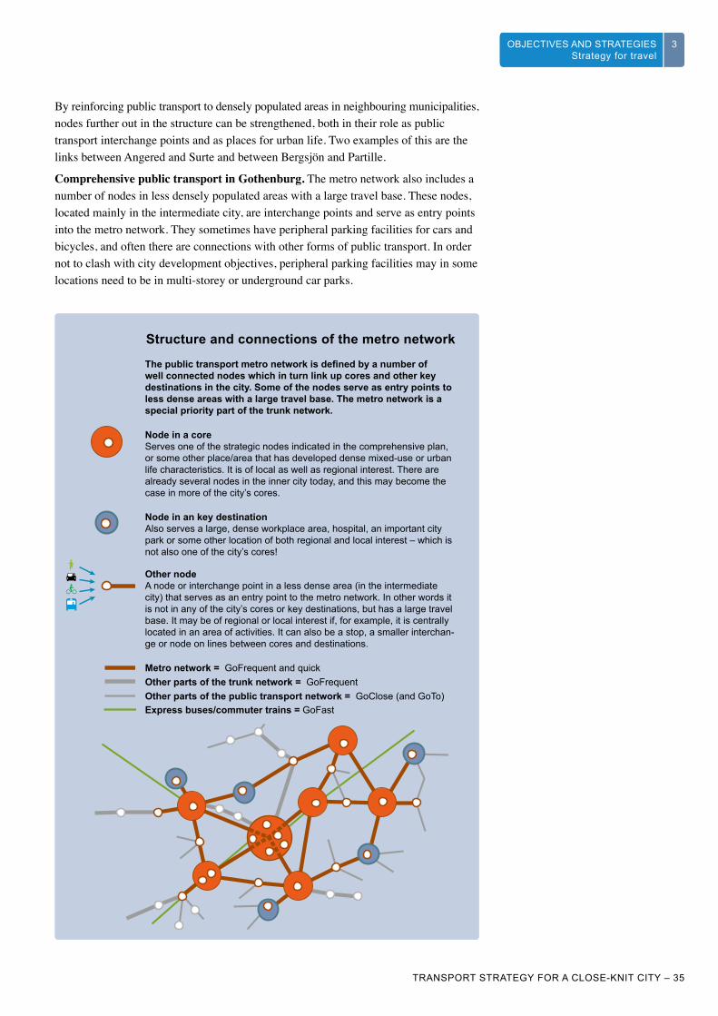
By reinforcing public transport to densely populated areas in neighbouring municipalities, nodes further out in the structure can be strengthened, both in their role as public transport interchange points and as places for urban life. Two examples of this are the links between Angered and Surte and between Bergsjön and Partille.
Comprehensive public transport in Gothenburg. The metro network also includes a number of nodes in less densely populated areas with a large travel base. These nodes, located mainly in the intermediate city, are interchange points and serve as entry points into the metro network. They sometimes have peripheral parking facilities for cars and bicycles, and often there are connections with other forms of public transport. In order not to clash with city development objectives, peripheral parking facilities may in some locations need to be in multi-storey or underground car parks.
Node in a coreServes one of the strategic nodes indicated in the comprehensive plan, or some other place/area that has developed dense mixed-use or urban life characteristics. It is of local as well as regional interest. There are already several nodes in the inner city today, and this may become the case in more of the city’s cores.
Node in an key destinationAlso serves a large, dense workplace area, hospital, an important city park or some other location of both regional and local interest – which is not also one of the city’s cores!
Other nodeA node or interchange point in a less dense area (in the intermediate city) that serves as an entry point to the metro network. In other words it is not in any of the city’s cores or key destinations, but has a large travel base. It may be of regional or local interest if, for example, it is centrally located in an area of activities. It can also be a stop, a smaller interchan-ge or node on lines between cores and destinations.
Metro network = GoFrequent and quickOther parts of the trunk network = GoFrequentOther parts of the public transport network = GoClose (and GoTo)Express buses/commuter trains = GoFast
The public transport metro network is defined by a number of well connected nodes which in turn link up cores and other key destinations in the city. Some of the nodes serve as entry points to less dense areas with a large travel base. The metro network is a special priority part of the trunk network.
Structure and connections of the metro network

WHAT IS GOTHENBURG’S TRANSPORT STRATEGY
3 CHALLENGES3
36 – TRANSPORT STRATEGY FOR A CLOSE-KNIT CITY
OBJECTIVES AND STRATEGIESStrategy for travel
3
Larger residential areas and other places farther out are served by GoFast traffic (e.g. express buses) along corridors, as are places in the region beyond Gothenburg. The GoFast traffic links up with the metro network’s nodes in central Gothenburg or other cores. Along GoFast corridors, development of peripheral parking facilities for both bicycles and cars will continue. Gothenburg will cooperate closely with other parts of the metropolitan area, primarily Mölndal city and Partille municipality.
Regional travel. The interdependence between Gothenburg and the surrounding region will increase, leading to more commuters and visitors. Improving travel possibilities within Gothenburg will make it easier to reach final destinations regardless of whether they are in or outside Gothenburg. An important part of this is to offer the possibility of changing between trains and the public transport metro network in semi-central areas around Gothenburg, e.g. in Gamlestaden. This will give more people shorter and faster journeys, while at the same time relieving the inner city. A new station at Brunnsbo along the Bohus line, with a connection to a metro network, is an example; another is moving Sävenäs station closer to Gamlestaden.
The West Link will increase train traffic capacity and also relieve the Central Station, but further investments in regional train traffic are needed in order to prevent an increase of inward car commuting. Gothenburg City will therefore participate actively in ensuring that both additional investments in the existing network and new investments are carried out during the strategy’s time frame. The Götaland line towards Borås is an important example of this. Another is the possibility of eventually building a new rail connection from the West Link southwards, along the corridor towards Särö.
At the regional level, too, one objective is to develop cores and other nodes along busy public transport corridors. By strengthening regional cores with more workplaces, a balance can be achieved for inward and outward Gothenburg travel, which is desirable e.g. for reasons of cost efficiency.
Discussions are ongoing about connecting the Oslo and Öresund regions with a high-speed rail link. From a traffic perspective it is important that a station be located in a city core where the metro network connects, but the issue is complex and will be investigated further.
Operation and maintenance. Building new infrastructure for bicycles and public transport will not be enough to achieve the objectives. If journeys are really to become fast and reliable, the city’s streets, roads and railways need to be maintained, which in turn requires resources that depend on how much and how we build.
Foto
: Han
s A
rby
THE SCANDINAVIAN8 MILLION CITY
Work is in progress to explore the possibility of a high-speed rail link between Oslo and Copenhagen via Gothenburg. Its progress can be followed on www.8millioncity.com.

WHAT IS GOTHENBURG’S TRANSPORT STRATEGY
3
TRANSPORT STRATEGY FOR A CLOSE-KNIT CITY – 37
CHALLENGES 3OBJECTIVES AND STRATEGIESStrategy for travel
3
Increasing access to neighbourhood services, retail outlets, meeting places and other everyday functions
Access to meeting places, culture, nature, food, wellness training and to meeting friends and taking part in leisure activities, training courses and other activities at home or in the neighbourhood reduces the necessity of travelling, or of travelling far. The transport strategy’s objective for an easily accessible regional centre is expressed thus: “it will be easy to reach key places and functions”. If the distance to some of the important functions is reduced, they become easier to reach on foot or by bicycle. Nearby access to everyday functions creates the conditions for lively and attractive neighbourhoods, and vice versa. Transport planning contributes to these developments by focusing on improvements for pedestrians and cyclists. The Development Planning Strategy contributes by creating the conditions for more people to live and work in the indicated areas, and the green strategy contributes by increasing access to green areas in the neighbourhood.
Increase access without any journey. People are increasingly online and use the internet for more and more tasks and errands. The city will facilitate online shopping of everyday commodities. Home deliveries or deliveries to the neighbourhood reduce the number of shopping trips by car, but increase the amount of distribution traffic the neighbourhood must be able to accommodate. Within its own organisation, the city will increase the share of travel-free meetings at the expense of business travel.
Increase local supply. Over the past few decades increased access has been synonymous with increased mobility, which has contributed to a relatively sparsely populated city. In order to achieve a development which is sustainable in every aspect, this paradigm needs to shift to increased access through increased supply in the neighbourhood. In that way, “structurally imposed” travel can be reduced and it can become easier to manage everyday tasks without having to own a car. If more errands can be taken care of within walking or cycling distance, this will bring many positive effects such as improved health for the individual, a safer and livelier neighbourhood and reduced pressure on the transport system as a whole.
The city planning committees and district committees need to work together to make it possible for more people to shop, receive services, deposit material for recycling and get to school, preschool or leisure activities in their neighbourhood. This is about strengthening local squares in existing areas by expanding them to increase the customer base and by a conscious localisation of public services, preschools and schools. But is also about increasing possibilities for the establishment of many small activities.
More residents means a larger base of customers, visitors and students, but in order for the potential to be realised it also needs to be easy and safe to get to the local square or other local destinations on foot or by bicycle. Focusing on pedestrians and cyclists by increasing the number of local pedestrian and bicycle paths, as well as the quality and attractiveness of bicycle parking facilities, is therefore decisive. Children’s opportunities for riding bicycles in the neighbourhood with or without adult accompaniment are particularly important, as travel habits are established at an early age. An important aspect of local supply is the possibility of easily reaching destinations that are a little farther away by means of good public transport. It is therefore important to have safe, efficient pedestrian paths and clear signposting between stops and local destinations such as city district centres, sports facilities and entrances to city district parks.
People’s possibilities for mobility contribute to reducing segregation, and for that reason measures which strengthen supply in the neighbourhood will primarily focus on reducing structurally imposed, longer journeys. The city will participate actively in research efforts into concepts such as supply in order to increase knowledge about potential, obstacles and social aspects when planning for a development that economises on travel.
2
EXTERNAL RETAILERS
When more everyday errands can be taken care of at home or in the neighbourhood, the need for external retailers of everyday goods is reduced.
NEIGHBOURHOOD
The neighbourhood is the area within walking distance of a home, which may vary depending on personal capacity, but a radius of 400 metres is regarded as a guideline value. In the Development Planning Strategy density is measured by the number of residents or workers within a radius of 1 kilometre.
“Imposed journeys” are journeys which, as opposed to “desired journeys”, are associated with displeasure, unwanted effort or sacrifice. Shortening this kind of journey is of course welcome, if it still yields what was intended: work, service etc. “Structural” means that the imposed travel – its extent – is determined by structural conditions such as the geographical division between work and home.
NOT ALL JOURNEYS ARE WELCOME
Read more about possibilities for developing the city’s neighbourhoods in the Development Planning Strategy and the green strategy.

WHAT IS GOTHENBURG’S TRANSPORT STRATEGY
3 CHALLENGES3
38 – TRANSPORT STRATEGY FOR A CLOSE-KNIT CITY
OBJECTIVES AND STRATEGIESStrategy for travel
3
Making more efficient use of roads and streetsMaking the use of roads and streets more efficient involves optimising the use of existing infrastructure. This is done through two types of measures – those that affect demand and thereby reduce car transport work, and those that affect how and where vehicles are moving, thereby increasing ease of passage. The first type falls within what is known as mobility management; the other within the term transport informatics. Often, these measures are connected, as in the case of congestion taxes and traffic information.
The car will continue to be an important means of transport in an easily accessible regional centre, even if not the most common. The physical, economic or climate-related margin for larger road investments will be small. This means that the continued ease of passage of car traffic is based on the entire increase in travel, at a minimum, occurring in other transport modes such as walking, cycling and public transport. More residents, visitors and activities means more goods transport, distribution and other utility traffic needing priority, while at the same time ease of passage for emergency vehicles must be guaranteed. This underlines the need for measures that make people able and willing to walk, cycle or use public transport more often.
Facilitate and stimulate flexible travelling. The need to own and use a car depends on urban planning as a whole, and on how well other transport modes meet people’s needs and expectations. The city will continue its dialogue with inhabitants, activities and other stakeholders in order to raise awareness about different travel possibilities. The city will also create better conditions for flexible travelling. This will be done by stimulating the emergence of new sustainable travel services, but also by adopting the users’ perspective when formulating and implementing measures. Examples of this include working with car sharing schemes, bicycle sharing schemes and extra consideration of road users in construction projects. The city’s various planning committees will use what are known as green transport plans as a strategic tool in the establishment of new and the expansion of existing transport intensive activities.
Use policy instruments to ensure ease of passage. When several different transport modes are possible for a journey, the traveller’s choice will be influenced by his/her knowledge and attitude, and by how incentives have been shaped.
Congestion taxes have created a powerful economic incentive which has led to reduced car traffic to and through central Gothenburg. The city’s parking policy has a similar effect. Gothenburg will continue to use and develop economic instruments as a way of maintaining good ease of passage for transport of goods, public transport and other utility traffic, as well as for those road users who lack realistic alternatives to the car. The unpopularity and effectiveness of the instruments are two sides of the same coin. They will therefore be based on communicable principles about the efficient use of shared, limited resources – principally space, money and air quality – and the fulfilment of a shared, attractive objective.
Information systems in traffic. Transport informatics is one tool for optimising the use of roads while at the same time increasing ease of passage for people and goods. This is about using information to support decisions about transport modes, starting times or routes before or during the journey or transport – but also about a more direct control and management of traffic. Making the transport system more efficient also lowers its sensitivity to disruptions, and increases travel time reliability.
The city will use transport informatics as a strategic tool to increase ease of passage in traffic and quality for all road users and activities, as well as participate in the regional, national and international development of useful systems and services. This
3
TRAVEL SERVICES
An integrated travel service can reduce households’ need for owning a car and can work as a packaged subscription to public transport journeys, car sharing and car hire services, taxi journeys, electric bicycle hire and modern versions of transport sharing systems.
TRANSPORT INFORMATICS
Transport informatics or ITS (Intelligent Transport Systems) refers to the use of information and communications technology in the transport area. ITS is used above all to inform, lead and direct road and transport users. ITS covers all transport modes and all parts of transport systems – vehicles, infrastructure, users and the surrounding environment.

WHAT IS GOTHENBURG’S TRANSPORT STRATEGY
3
TRANSPORT STRATEGY FOR A CLOSE-KNIT CITY – 39
CHALLENGES 3OBJECTIVES AND STRATEGIESStrategy for travel
3
also applies to applications for the improvement of ease of passage and quality in rail and other public transport. Together with other road operators and authorities, and in collaboration with commercial actors, the city will offer quality assured information to road users and promote innovation, e.g. by offering “open source data” and prepared test routes.
The interaction between different types of vehicles and the transport and urban space will increase, which underlines the importance of the city offering a digital infrastructure alongside streets and roads.
The Urban Transport Administration’s app “Cykelstaden” (Cycle City) facilitates cycling, but is also a platform for complaints and other feedback to the city. Cycle City is based on open source data (data.goteborg.se) from different operations within the city, which is available for other developers of IT services.
Coordinated traffic management: During 2013-2014, the Urban Transport Administration and the Swedish Transport Administration are running a trial activity with the goal of informing and guiding road users around the clock. The trial is being run in close collaboration with roadside assistance and rescue services, the police and public transport.
Drive CloseIn all environments where unprotected road users interact with motor vehicle traffic, vehicle speeds need to be low – from walking speed to 30 km/h. That is a human speed interval, where the risk of fatalities or serious injuries from collisions is low.
Drive InA densely populated environment needs a principal street network that allows users to drive all the way to the city district or area in the city they need to reach. This principal street network is not for through traffic, however (except for public transport), and vehicle speeds are deter-mined by the crossing demands of the people in the city along each section. Signposted speeds in this principal street network can vary between 30 and 60 km/h.
Drive BusThere are routes in the intermediate city which are used by, or expected to be used by, express buses and where ease of passage needs to be very good. Signposted speeds can vary between 60 and 80 km/h.
Drive RoundThere is a principal road network in Gothenburg which is made up mainly of national and regional roads. The road network fulfils an important function for business transports and public transport, and constitutes the trunk route for car traffic movements. Traffic here must flow as efficiently as possible, and signposted speeds can vary between 60 and 80 km/h.
Fundamental structure for the use of roads and streets
VAD ÄR GÖTEBORGS TRAFIKSTRATEGI
3UTMANINGAR 33OBJECTIVES AND STRATEGIESStrategy for travel
Pho
to: P
hoto
cre
dit

THE CAR IN A CLOSE-KNIT CITYThe car, and the individual’s vehicle of the future, will be needed to create an easily accessible regional centre and to hold the entire close-knit city together. There are many areas where it isn’t economically viable to offer good public transport, or where distances are too great to cycle or walk, or where the car provides functions the alternatives do not. The car as transport mode is necessary for many service industries and for those with special needs, regardless of where in the city they are.
In order for the car to be able to fulfil that role even as more residents, workers and visitors move around the city, more people need to both be able to and want to choose other transport modes. A central part of the transport strategy is to create the possibilities for many more people to walk or to use public transport or a bicycle for a larger share of their journeys. That way the car will become a complement for many people, used for getting to an interchange with good public transport, for making certain shopping journeys or for visiting family and friends outside the city.
It will be possible to use a car in the inner city and other urban environments, but for space, safety and attractiveness reasons, such use will be on pedestrians’ and cyclists’ terms. It will be simple and reliable to get around by car – which is not always the case today –, but it will be at speeds suited to the people who live and move around there. It will be easy to park, but there will be fewer parking spaces in streets and squares, and the price of parking will reflect the cost of building new parking spaces on attractive land.
There is a major challenge in maintaining cohesion between the central city and less dense areas outside it. Those who move around the central city on an everyday basis will not need a car, while those who live, work or have daily errands in other areas are more or less dependent on the car to get their daily life together. There is a risk that congestion taxes, possible
environmental zones or requirements for electric cars reinforce the differences between “inside” and “outside”, and that people and businesses organise themselves for a life on one side or the other. The possibility of travelling relatively freely between different types of areas is important. It applies to the flat owner in Majorna who needs a car in order to pursue leisure interests outside the city and to the house owner from the suburb who wants to leave the car outside of the congestion tax zone.
Gothenburg will therefore become a leader in integrating the vehicles of the future into the close-knit city. Other sections of the transport strategy describe the willingness to let Gothenburg become a testing ground for innovations. Gothenburg has a strong knowledge cluster in transports and transport informatics. A successful and competent vehicle industry is continuously developing cleaner and more efficient cars. Cars, buses and lorries of the plug-in hybrid type – or pure electric vehicles – drive quietly and without emissions in the city, but also have the range capacity for journeys or transports outside it. It is likely that we will have a more mixed car fleet in 20 years. Having access to a car where and when you need it by means of various car hire options, instead owning your own, will save space and money for individual households as well as society. Self-parking vehicles can dramatically reduce the total space needed for a parking area. And what will happen if we dare let self-driving cars onto the scene?
Illus
tratio
n: V
olvo
Car
s

WHAT IS GOTHENBURG’S TRANSPORT STRATEGY
3
TRANSPORT STRATEGY FOR A CLOSE-KNIT CITY – 41
CHALLENGES 33
TRANSPORT WORK
Transport work is the appropriate unit for measuring climate impact (measured in vehicle kilometres). In order also to capture effects such as congestion, air quality and parking needs in densely populated areas, the traffic strategy’s effect targets are instead based on the number of journeys, expressed in terms of shares for each transport mode.
Effect targets for journeys
By 2035 at least 35 per cent of journeys in Gothenburg will be taken on foot or by bicycle
In a close-knit city it will have become possible for many more people to do their errands on foot or by bicycle. It is therefore an important objective that a larger share of journeys in Gothenburg are taken on foot or by bicycle by 2035. Today that share is 26 per cent. The target implies a doubling of the number of journeys on foot and by bicycle.
The target is based on an assessment of how large a share of current short journeys by public transport or car can be replaced by a journey on foot or by bicycle, and also on an assessment of how many more errands can be carried out within walking or cycling distance.
By 2035 at least 55 per cent of motorised journeys in Gothenburg will be by public transport
According to a travel survey from 2011, the public transport share of all journeys in Gothenburg (to, from and within the city) is 24 per cent, which corresponds to 34 per cent of motorised journeys. The transport strategy’s target implies almost a doubling of the number of public transport journeys and, together with the doubling in cycling and walking, that the number of car journeys is reduced by a quarter.
K2020 has the target that at least 40 per cent of all motorised journeys will be by public transport by 2025. The target includes journeys to, from and within the Gothenburg area, which also includes northern part of Mölndal, central Partille and west Härryda. In order for the K2020 target to be met, journeys in Gothenburg need to shift from cars to public transport to an even greater degree.
OBJECTIVES AND STRATEGIESStrategy for travel
TRANSPORT MODE DISTRIBUTION
Transport mode distribution is the most common way of measuring travel behaviour, and is used to set long-term targets and monitor changes in travel habits. The transport strategy’s effect targets for transport mode distribution include all person-journeys and all types of errands. The targets will be followed up by means of travel habits studies and be validated through journey counts for the different transport modes.
WHAT THE EFFECT TARGETS IMPLY
A doubling of the number of journeys on foot or by bicycle.
A doubling of the number of public transport journeys.
A reduction by a quarter of the number of car journeys.
EFFECT TARGET
An effect target is a tool for the concrete application of a strategy and for its subsequent follow-up. What will the result of following the strategy be? The effect target has to be relevant to the strategy, be communicable and help identify necessary measures.
E1
E2
The city’s role as regional centre makes it pertinent to set targets for and monitor the development for all journeys taken to, from and within Gothenburg – even if they are mainly taken by the city’s inhabitants (approx. 80 per cent in 2011). The strategy for journeys will lead to measures that give everyone, including visitors and inward commuters, good opportunities for choosing a sustainable transport mode.
As Gothenburg and the region grow, the total number of journeys will increase – by 27 per cent according to estimates. The national prognosis predicts that the number of journeys by private car will increase by approx. 35 per cent to 2030, while climate objectives indicate that this number needs to be reduced.
The transport strategy’s targets for transport mode distribution corresponds to a reduction in the number of car journeys by 25 per cent on the 2011 number. If the effect targets above are met – and technological development leads to considerably more climate-smart vehicles – the targets for climate gas emissions by passenger transports will also be met.
Traveller growth and transport mode distribution for journeys in Gothenburg
By car
By other transport modes
By public transport
By bicycle
On foot
2011 Effect target 2035

WHAT IS GOTHENBURG’S TRANSPORT STRATEGY
3 CHALLENGES3
42 – TRANSPORT STRATEGY FOR A CLOSE-KNIT CITY
OBJECTIVES AND STRATEGIESStrategy for travel
3
The travel time between two random cores or key destinations is a maximum of 30 minutes by car and
public transportAccessibility by car is already very good in Gothenburg. Today it is possible to reach all types of places, in principle, from any starting point in the municipality, within 30 minutes by car. That is not how it looks for the person choosing to go by public transport. Travel times for more than 25 per cent of the journeys between the indicated cores and destinations are today longer, or considerably longer, than 30 minutes. For that reason, priority is given to measures that shorten travel times and increase public transport capacity. The travel time quotient (public transport journey/car journey) influences the choice of transport mode and is therefore an important indicator, but as it is a relative measurement it is not relevant for measuring accessibility. Areas from which you can reach 50 per cent of the city’s workplaces within 30 minutes on public transport are regarded as having very good accessibility in Gothenburg, and 30 minutes is often the limit used travel decisions. In order to meet the 30-minute target, public transport through and around the inner city in particular need to be speeded up. This measurement is thus sufficient when choosing solutions, prioritising measures and doing follow-ups.
Note that the target applies to private car and distribution traffic, but does not specify anything in respect of costs or speeds on certain stretches.
The four-stage principle
The four-stage principle is an approach to planning within the road transport system which means that possible improvements to the transport system are carried out as part of an overall assessment of different measures.
Stage one: RethinkThe first stage includes measures that can affect the need for transports and journeys.
Stage two: OptimiseThe second stage includes measures that involve more efficient use of existing infrastructure.
Stage three: RebuildWhen needed, the third stage is implemented by carrying out limited building conversions.
Stage four: Build newThe fourth stage is implemented if it has not been possible to meet the need in the previous three stages. This means new investments and/or major building conversions.
E3ACCESSIBILITY
Accessibility can be defined as how easy it is for citizens, businesses and public organisations to reach the supply and the activities they need. The degree of accessibility depends on how big a sacrifice is made in reaching the desired destination, in terms of travel time, costs, obstacles, security and access to transport modes.

WHAT IS GOTHENBURG’S TRANSPORT STRATEGY
3
TRANSPORT STRATEGY FOR A CLOSE-KNIT CITY – 43
CHALLENGES 3OBJECTIVES AND STRATEGIESStrategy for travel
3
EXAMPLES OF MEASURESStage one: Rethink Deliberate planning and placing of public services.
Reserved parking spaces for car sharing schemes by local squares, cores, key destinations and nodes.
Draw up more green transport plans (from Gothenburg’s environmental programme).
Stage two: Optimise More and extended smart peripheral and commuter parking facilities.
A time-regulated priority system for goods and public transport.
Work to achieve lowered speeds along entry routes (from Gothenburg’s environmental programme).
Coordinated traffic management, shared between the region’s transport principals.
New engine solutions for public transport and distribution vehicles.
Coordinate and improve operation and maintenance of bicycle paths (from Gothenburg’s environmental programme).
Increase comfort on public transport by designing and maintaining traffic lanes, rail tracks and stops in accordance with customer-centred quality control.
Stage three: Rebuild Priority pedestrian and bicycle lanes between cores and destinations.
Rearrangement of road and street space in favour of a comprehensive bicycle network.
Increased space for pedestrians and cyclists in neighbourhoods around local squares.
Conversion of existing road and street lanes into public transport lanes.
Stage four: Build new Tram expansion in line with intentions in K2020:
• Tram line to Backa
• Tram line to Eriksberg
• Tram connection between Linnéplatsen, Stigbergstorget and Lindholmen (“the Lindholm connection”).
A metro network between cores which does not hinder urban development may require new, big solutions, from a tram line along Allén to putting tram lines in tunnels or on viaducts, or new systems – for Gothenburg – such as light rail, tram-trains, subway or, in some places, overhead cableway.
Depots and parking facilities for public transport vehicles.
A rail tunnel beneath the river for the Bohus line from Brunnsbro, connecting at Gothenburg Central, and a rail tunnel from Haga station south towards Särö.
An interregional station to accommodate e.g. high-speed trains (the Götaland line and Oslo-Copenhagen) in a new or partly new location.
Development of a clearly separated commuter bicycle network.
Build a pedestrian and bicycle bridge across the river (from Gothenburg’s environmental programme).
Marklandsgatan
Linnéplatsen
Korsvägen
SvingelnLindholmen
Masthuggs-torget
Järntorget
Haga church
Avenyn
Brunns-parken
Gbg C
HjalmarBranting pl
The tram network – fundamental structure in central Gothenburg.Source: K2020

WHAT IS GOTHENBURG’S TRANSPORT STRATEGY
3 CHALLENGES3
44 – TRANSPORT STRATEGY FOR A CLOSE-KNIT CITY
3 OBJECTIVES AND STRATEGIESUrban space strategy
URBAN SPACE STRATEGY
We will create attractive urban environments and a vibrant urban life in Gothenburg by:
Prioritising pedestrians and cyclists and adapting speeds mainly to pedestrians (movement)Adapting streetscapes and speeds in the first instance to pedestrians and in the second instance to the needs and conditions of cyclists will lay the foundation for safe, secure, lively streets, without excluding other types of road user.
Rearranging the streetscape to create more space where people want to be and where they can move around (space)Space is a limited resource in urban environments. Reallocating space between types of traffic and between traffic and the people within the area pursuing different activities will create conditions for attractive, lively and thus safer urban spaces. Parking should primarily be in multi-storey car parks and garages, and goods distribution should take place mainly at times when it disturbs as few people as possible.
Creating a denser and more interconnected network of streets without barriers (structure)Navigability, route efficiency and the absence of barriers in the street network make it easier to move around, thus consolidating the city and spreading urban life to more places. The dense and interconnected street network exists for all modes of transport, as long as flows and speeds do not create new barriers.
WHERE THE URBAN ENVIRONMENTS ARE
Urban environments can be defined on the basis of competition for land. When sufficient numbers of people spend time in and move around an area, the conditions for retail, restaurants and other services that we associate with urban environments arise. Today central Gothenburg is a more or less continuous urban environment, but we don’t find urban environments in many other places. The Development Planning Strategy shows which locations have the potential to develop into urban environments, provided more people begin to live or work there.
1
2
3
Pho
to: H
ans
Arb
y

WHAT IS GOTHENBURG’S TRANSPORT STRATEGY
3
TRANSPORT STRATEGY FOR A CLOSE-KNIT CITY – 45
CHALLENGES 33OBJECTIVES AND STRATEGIESUrban space strategy
Prioritising pedestrians and cyclists and adapting speeds mainly to pedestrians
People in movement are the lifeblood of the city. They contribute to increased safety, create a greater basis for service and, more than anything else, constitute the attractiveness we associate with cities. Moving around on foot creates good opportunities for meetings and social interaction. Improving conditions for pedestrians therefore has an intrinsic value for a city that wishes to have a vibrant urban life. Everyone, regardless of age and physical ability, should feel that they can walk safely and securely because the speed of vehicle traffic has been adapted to pedestrians. The design of paths and intersections give priority to pedestrians. The cyclist is also important in the city’s transport system. The bicycle is an efficient and fast means of transport that contributes to an attractive urban space with more life without being noisy or polluting the air. Priority for cyclists in the urban space means that it is clear where and how to cycle, and that the design of both paths and intersections are adapted to cyclists’ demands for ease of passage – but always taking pedestrians’ needs into consideration.
Human speed is a prerequisite for an attractive urban environment. Ambitions for Gothenburg’s successful road safety programme will continue to be high, with ever fewer people injured in traffic. A key factor for a safe and attractive urban environment without barriers is that wherever pedestrians and cyclists move, spend time and interact with other traffic, human speed will be the standard. Lower vehicle traffic speeds also reduces noise. Low vehicle speeds mean that the interaction between road users improves, which in turn creates conditions for improved flows in motor vehicle traffic. This can contribute to better air quality, which has a positive effects on people’s health. Low speeds will be the emphasis for the vast majority of streets in urban environments.
Public transport sometimes has to have its priority raised, and sometimes lowered. In some places, public transport requirements for ease of passage and speed come into conflict with unprotected road users’ needs in terms of urban life and human speed. It will be necessary to reach compromises between transport modes, where public transport in some environments will have to adapt to the speed of pedestrians and vice versa. Since just about all public transport in urban environments today runs at ground level, the city needs to secure means, in collaboration with the state and the region, of giving public transport with high demands on speed and capacity new trajectories, particularly through the inner city. The solutions to this will probably involve moving parts of public transport underground or raising it above ground level. As a compromise option, the possibility of differentiated speeds between public transport and surrounding vehicle traffic will be explored.
Create a balance in the encounter between pedestrians and cyclists. As dense urban environments increase in number, become larger and are increasingly accessed with other transport modes than the car, conflicts between cyclists and pedestrians will become an increasingly important issue to manage.
Fast bicycle lanes can create barriers for pedestrians, and in some environments it will become necessary for bicycle traffic, just as for public transport, to accept compromises in which it has to adapt to pedestrians’ speed, and vice versa. At specific points where pedestrian flows are large and where ease of passage for bicycle traffic is prioritised, solutions involving separation should be tried, e.g. by redirecting bicycle lanes or building multilevel junctions.
STRATEGIES IN GOTHENBURG CITY’S ROAD SAFETY PROGRAMME 2010-2020
• We will work to prioritise road safety in city development.
• We will prioritise unprotected road users.
• We will motivate people to have an increased sense of responsibility in traffic.
• We will work to achieve more safe vehicles and transports.
• We will continue to control speeds in our street environments.
• We will lay the foundations of safety consciousness among children and young people.
1
KROCKVÅLDSKURVAN
00
10
20
30
40
50
60
70
80
90
100
Risk of death (%)
(km/h)10 20 30 40 50 60 70
30
30
50
50
Human speeds mean that traffic environments need to have speeds controlled at a maximum of 30 km/h.

WHAT IS GOTHENBURG’S TRANSPORT STRATEGY
3 CHALLENGES3
46 – TRANSPORT STRATEGY FOR A CLOSE-KNIT CITY
3 OBJECTIVES AND STRATEGIESUrban space strategy
Rearranging the streetscape to create more space where people want to be and where they can move around
As Gothenburg becomes denser, many more people will be moving around in the city. Already there are several places that get very congested during the rush hour, when many people are walking, cycling, riding the bus or tram or driving a car along the same corridor. But the street space is not just for transport – it is also a place to be, with the potential for further development. You don’t have to have an errand or be working or living in the city in order to experience urban environments. Many people take a stroll, go jogging, go to cafés, spend time with friends, or visit Gothenburg as tourists.
More people in the same space requires a rearrangement of the street environment. In an existing, dense urban environment, the width of the street space is often a given. How this width is used has a lot to do with what speed demands are going to be met for different road users and what flows of road users are going to be able to pass. In order to provide space for people and urban life we need to rethink this, and give more space to large-capacity transport modes such as pedestrians and public transport. Vehicles with a higher speed require more space, which means that motor vehicles occupy a relatively large space per traveller – and even more if parking is added. With lower speeds in the urban environment, the space per motor vehicle can be reduced through narrower lanes and smaller radii, while the accessibility for car users and distribution transports is maintained. This way, space is freed up for wider pavements with the possibility for sauntering, walking or hurrying in the same space. Cyclists occupy a relatively large amount of space in the street section when they have their own lane. In narrow street sections, therefore, it may be a good idea to have cyclists and cars share the same lane. This way of shaping the city’s streets and roads is based on speed separation rather than separation between types of traffic. The environment thus becomes more user-friendly for children, elderly people and people with impairments.
0–6 7–14 15–20 21–40 41–65 65–
20 to 40-year-olds are currently overrepresented among people who spend time in streets and squares in central Gothenburg.
SOCIAL MIXINGIN THE STREET SPACE – AGE GROUPS
Area (m2)per traveller
0.8 1.2 2.1 9.7 22.1
PEDESTRIANS
TRAM BUS
BICYCLE
PRIVATE CAR
The space demands of different transport modes vary. A moving pedestrian takes up considerably less space than a cyclist or a car. The calculations behind the illustration were taken from a Norwegian study and have not been checked against the realities of Gothenburg traffic, but they nevertheless give an idea of the relationship between the transport modes.Source: Norheim, Bård and Stangeby, Ingunn: Fakta om kollektivtrafikk. Transportøkonomisk institutt, Oslo, 1995.
SPEED SEPARATION
“Walking speed area”: cycling and driving a car are permitted, but on pedestrians’ terms.“Cycling speed area”: driving a car is permitted, but on cyclists’ terms.
2
In cycling speed areas, bicycles share the space with cars.
Sou
rce:
Sta
dsliv
et i
cent
ral G
öteb
org
(“U
rban
life
in
cent
ral G
othe
nbur
g”) [
the
City
Pla
nnin
g O
ffice
, 201
2]P
hoto
: Asb
jörn
Han
ssen

WHAT IS GOTHENBURG’S TRANSPORT STRATEGY
3
TRANSPORT STRATEGY FOR A CLOSE-KNIT CITY – 47
CHALLENGES 33OBJECTIVES AND STRATEGIESUrban space strategy
It is crucial that the city abides by the intentions of the parking policy. The city’s management of parking spaces in urban environments is key to the possibility of creating space for urban life. The parking policy points to the need for more bicycle parking facilities near the final destinations of cyclists. Street space which is currently used as parking for cars needs to be freed up by shifting parking spaces to parking facilities such as multi-storey car parks. The city’s ongoing work on bicycle programmes and guidelines for parking in inner Gothenburg will propose concrete solutions to these questions.
Turning infrastructure areas to urban space. Parts of Gothenburg is formed by the time when there was plenty of space to build on and when the dominating principle of planning was to separate different types of traffic. This has lead to an oversized infrastructure in many places in Gothenburg. There is a potential to create dense urban spaces by reallocating space being used for infrastructure to buildings and by turning traffic routes into city streets. This possibility is particularly interesting in parts of the city identified by the strategy for development planning as areas of consolidation.
THE ACCESSIBILITY PROGRAMME
How the city space is designed is especially important for persons with disabilities. The accessibility programme describes how the city should be shaped in order for the city space to be perceived as being safe, regardless of mental and physical conditions.
CHILDREN IN THE DENSE CITY
The city is growing, which also means that there will be more children and young people living and moving around in the city. How will the dense city look like to children? Where will they find the safe areas for learning to cycle? Where will young people hang out? How do the routes leading to the schools look like? These are aspects and questions that has to be part of our approach when developing urban areas. Child impact assessments will secure the inclusion of the children’s perspective in the process.
Pho
to: J
onas
And
erss
on
In Lyon, parking garages have been built on the quayside.
A possible idea for transforming Vågmästareplatsen.
Illus
tratio
n: R
ambö
ll

WHAT IS GOTHENBURG’S TRANSPORT STRATEGY
3 CHALLENGES3
48 – TRANSPORT STRATEGY FOR A CLOSE-KNIT CITY
3 OBJECTIVES AND STRATEGIESUrban space strategy
Optimise goods distribution. Goods distribution to various trade and retail areas in Gothenburg is generally carried out by heavy vehicles (over 3.5 tons). The areas vary in character, and bulky goods are more common in the external trade areas than in the centre. The solutions, including choice of the size and type of goods vehicle, need to be adapted to the conditions in each area.
Accessibility for goods deliveries is a central concept for goods distribution in densely populated areas. Good accessibility is created by a combination of efficient infrastructure, policy instruments and new transport systems. Examples of this include more walking speed areas, local traffic regulations and time windows for goods distribution, as well as new concepts such as Stadsleveransen. As well as contributing to the optimising of goods flows in the urban environment, the city will also encourage a wider use of clean vehicles and test new solutions. An example of the latter is to make greater use of the river for the distribution of goods in the inner city. In its procurements, the city will specify requirements to minimise the socioeconomic costs of transports. This can be done by minimising transport work and by carrying out goods distribution with clean vehicles. Hybrid electric and electric vehicles don’t just have lower emissions – they also make less noise. Waste management is also a purchased service, for which corresponding requirements will be specified.
GOOD EXAMPLES IN EUROPE
Several European cities are working successfully to create attractive urban environments where goods distribution is part of city planning. Examples include Graz, Utrecht, Bologna and Barcelona.
Easy to deliver in walking speed areas: The transformation of ordinary streets into streets where parking is not permitted has made deliveries to shops easier. The delivery vehicle can stop immediately outside, which reduces transport work as well as unloading and loading times.
Distribution by bicycle: Move by Bike is Sweden’s first bicycle haulier.
In densely populated areas, locally coordinated goods distribution can improve the service offered to retailers while at the same time
reducing the risk of conflicts between heavy distribution vehicles and unprotected road users.
Pho
to: A
sbjö
rn H
anss
en
Pho
to: A
sbjö
rn H
anss
enP
hoto
: Mat
s U
dde
Jons
son

WHAT IS GOTHENBURG’S TRANSPORT STRATEGY
3
TRANSPORT STRATEGY FOR A CLOSE-KNIT CITY – 49
CHALLENGES 3OBJECTIVES AND STRATEGIESStrategy for travel
3
EXTRACT FROM THE PARKING POLICYAdopted in October by 2009 by the City Council
ATTRACTIVEURBANENVIRONMENT
GOODACCESSIBILITY
LOWENVIRONMENTALIMPACT
Balancing of overallaccessibility Improved accessibility
through public transportand cycling
-Less accessibility bycar for work commuters
The right location
Good configuration– secure and attractive
Prioritise the urban environmentover car parking
Increase travel by severaltransport modes
Promote cleaner vehiclesand shared use
Better conditions forpublic transport and cycling
ParkeringsPolicy för göteborgs stad
antagen av kommunfullmäktige 2009-10-08
Aims for car parking The policy’s aim is for the inner city to maintain about the same number of parking spaces as today. These spaces may need to be redistributed e.g. to make way for new public transport and bicycle lanes, beautifying urban environments, or to give priority to other types of parking. As public transport expands, however, conditions will be created for reducing the number of car parking spaces, particularly in areas adjacent to good public transport.
Extract from Areas for strategic measures:
– Change current car parking spaces in the inner city
– Plan for unchanged access to the Events Area
– Promote car sharing
– Use fees and time limited parking to achieve the goals
– Prioritise short-stay and half-day parking
– Provide parking for residents on private land
– Prioritise the urban environment over car parking
– Adapt parking to the cityscape
– Replace ground parking with joint facilities
– Build safely, securely and attractively
– Test car parking-free areas
Aims for bicycle parking The number of organised bicycle parking facilities should be increased in central Gothenburg, within convenient walking distance to destinations. Bicycle parking will also be arranged at peripheral and commuter parking facilities, and by all major public transport stops. Bicycle parking by homes and workplaces will be arranged on private land.
Parking facilities will be secure, of good quality, be sheltered from the weather and have the possibility of locking bicycles to a fixed post, or indoors.

WHAT IS GOTHENBURG’S TRANSPORT STRATEGY
3 CHALLENGES3
50 – TRANSPORT STRATEGY FOR A CLOSE-KNIT CITY
3 OBJECTIVES AND STRATEGIESUrban space strategy
A TRADITIONAL CITY OF STREET BLOCKS
A dense and small scale structure of streets and blocks brings great advantages for urban life.
THE MOST COMMON ACTIVITIES
Waiting
Talking
Recreation(rest andphysicalactivity)
Shopping
Outdoorcafés andrestaurants
Queuing/Culture/Selling/Promoting
Streets and squares are not only used for movement, but also for other forms of urban life. In 2011 an inventory was made of what people do in some of the most important places in central Gothenburg.
Creating a denser and more interconnected network of streets without barriers
The scale of different cities’ street structure varies. The number of intersections per square kilometre differs by a factor of a hundred between Venice, with 1,500, and the American city of Irvine, which has 15. The concept of accessibility has to do precisely with how reachable a place is, and thereby with how easy it is to find your way there. By having a denser and more interconnected street network, more places become accessible, which increases the flow of people and thereby the potential for urban life.
A dense street network for everyone moving around in the urban environment. A dense street network for pedestrians provides more route choices and greater variation. It also creates a greater number of more integrated squares in the city, and more public spaces. Better structural conditions for getting around in the city also provides the basis for a more vibrant and dynamic city life, in more places. Cyclists want to be able to get close to their destination, and therefore need a route-efficient and dense network of bicycle paths, as well as public bicycle parking facilities on every block. For the motorist as well, a dense network is important for the possibility of finding one’s way and getting all the way to destinations in the urban environment when necessary. A denser street network can be achieved through shorter street blocks or passageways through blocks such as Viktoriapassagen. Other ways include creating more and better crossings on traffic-intensive thoroughfares and streets, or linking separate streets to each other. For cyclists and motorists, it’s all about being as free as possible to use the street network to find the best route, e.g. by increasing the number of two-way streets.
Healing the city into one. The feeling of security, i.e. to be able to, want to and dare to move freely around the city at all hours of the day and night, is very significant for a city’s attractiveness. By designing well-maintained, open street spaces which are well connected to the surroundings and where it is easy to find one’s way, you create places where people like to be. The potential for change is great in central transformation areas, but action is needed in existing environments too. This might involve bridging barriers where the flow of vehicles is high. It might also involve altering traffic-separated areas so that you get a mix of different types of road user, creating increased security. By connecting streets that are currently separate into longer stretches edged by major destinations, the city is “healed into one” in a physical sense, which also has positive social effects. When the inner city is going to expand, the existing long stretches of interconnected streets can be extended into the new districts, while the most accessible pedestrian and bicycle lanes are adapted to an increased flow.
A safe and attractive city requires running and maintenance. If an interconnected network is to be perceived as safe, this also implies investments in running and maintaining it: more lighting during more hours of the day, more cleaning and more removal of graffiti. Safe street environments requiring more efforts to run cost more money. Investing in running and maintenance is therefore a necessity for the attractive city.
3
Sou
rce:
Urb
an li
fe in
cen
tral G
othe
nbur
g (th
e C
ity P
lann
ing
Offi
ce, 2
012)
Sou
rce:
City
pla
nnin
g qu
aliti
es in
Got
henb
urg
(the
City
Pla
nnin
g O
ffice
, 200
8)

WHAT IS GOTHENBURG’S TRANSPORT STRATEGY
3
TRANSPORT STRATEGY FOR A CLOSE-KNIT CITY – 51
CHALLENGES 33OBJECTIVES AND STRATEGIESUrban space strategy
Effect targets for urban spaces
By 2035, at least XX per cent of Gothenburgers consider walking to be the most attractive way of moving around the inner city and other urban environments
Gothenburgers’ perception that urban environments are adapted to pedestrians is an important confirmation that transformation efforts are following the strategy. The effect target is intended to reflect both actions carried out during an intensive building phase and the finished result. The effect target is complemented by a number of indicators to ensure the link between actions and effects. Data on the current situation is lacking, so an attitude survey will be carried out during 2014. The target will then be set based on the city’s ambition as well as planned and desired changes. The target and its follow-up will be influenced by the circumstance that the geographical extent of the inner city will gradually change, and that the Development Planning Strategy has pinpointed places for consolidation. For this reason, parallel series of measurements with different geographical definitions may become necessary.
By 2035, at least XX per cent of Gothenburgers consider street spaces in the inner city and in other urban environments to be
attractive places to be. Gothenburgers’ perception that investments in urban environments lead to more nume-rous and attractive urban spaces to spend time in is an important confirmation that trans-formation efforts are following the strategy. The effect target is intended to reflect both actions carried out during an intensive building phase and the finished result. The effect target is complemented by a number of indicators to ensure the link between actions and effects. Data on the current situation is lacking, so an attitude survey will be carried out during 2014. The target will then be set based on the city’s ambition as well as planned and desired changes. The target and its follow-up will be influenced by the circumstance that the geographical extent of the inner city will gradually change, and that the Develop-ment Planning Strategy has pinpointed places for consolidation. For this reason, parallel series of measurements with different geographical definitions may become necessary.
By 2020, the number of fatalities, serious and light injuries in Gothenburg traffic will have been reduced by 75 per cent on
the 2010 figure. The target in Gothenburg’s road safety programme is a halving of the number of injured and killed between 2010 and 2015, and a further halving of that number by 2020. A new target for 2030-2035 will be set in the coming version of the road safety programme, and will then be changed in the transport strategy as well.
E4
E5
E6
TR AFIKSÄK ERHE T SPROGR AM 2010 – 2020
Rapport 2:2009TrafikkontoretIssn 1103-1530
År 2020Fler rör sig i staden. Men färre skadas i trafiken
THE NUMBER OF FATALITIES IN TRAFFIC 2000-2008 ANDTHE TARGET FOR 2020
THE NUMBER OF INJURED IN TRAFFIC 2000-2008 AND THETARGET FOR 2020
0
5
10
15
2000
2001
2002
2003
2004
2005
2006
2007
2008
2009
2010
2011
2012
2013
2014
2015
2016
2017
2018
2019
2020
0
100
200
300
400
500
2000
2001
2002
2003
2004
2005
2006
2007
2008
2009
2010
2011
2012
2013
2014
2015
2016
2017
2018
2019
2020
Targets for the Road safety programme

Pho
to: H
ans
Arb
y

EXAMPLES OF MEASURESStage one: Rethink Develop services that make it easier to choose among sustainable transport modes – current examples include the city’s bicycle app and trafiken.nu.
Work towards a gradual transition to distribution vehicles with other engine solutions, e.g. electric motors.
Communicate the gains of awareness in travel habits by means of concepts such as New road habits.
Work more systematically with guidance, maps and information for pedestrians.
Stage two: Optimise Move car parking from the street space to parking facilities.
Build more bicycle parking facilities in the dense urban environment. Offer bicycle services such as bicycle maintenance.
Provide more spaces for car sharing schemes and bicycle sharing schemes.
Make flexible use of the street space, e.g. bicycle parking facilities or outdoor furniture during the spring, summer and autumn, and car parking the rest of the time.
Establish test areas for automatic vehicle parking (from Gothenburg’s environmental programme).
Lower speeds in the city (from Gothenburg’s environmental programme).
Stage three: Rebuild Reduce the barrier effects of the large thoroughfares. Transforming them into
city boulevards, adding more multilevel crossings or covering them are possible options.
Transformation of Hjalmar Brantingsgatan from a traffic landscape into a urban space (in connection with the expansion of Kvillemotet.)
Transformation of Dag Hammarskjöldsleden from a traffic landscape into a city boulevard.
Change the arrangement of the street space in connection with other transformations of the urban environment, e.g. in connection with the development of stations along the West Link or when the public transport system is converted or extended.
Build more cycling speed areas. Västra Hamngatan has been converted into a cycling speed area; Östra Hamngatan will be converted in 2014.
Transform the infrastructure solutions in Bergsjön in connection with other development projects.
Create more walking speed areas in the centre (from Gothenburg’s environmental programme).
Stage four: Build new Create more river crossings to link up the “old” centre with new inner city districts on Hisingen.
Create more connections across Vallgraven for pedestrians and cyclists.
Move public transport underground or raise it above ground level, through or around the centre.

33
54 – TRANSPORT STRATEGY FOR A CLOSE-KNIT CITY
3
GOODS TRANSPORT STRATEGY
Gothenburg has many industry and logistics activities and a strong knowledge base in the transport area. The city’s universities are dynamic and respected, and it is home to the world’s largest maker of trucks. Gothenburg has many companies with large goods volumes, and the largest port Scandinavia, which handles a considerable proportion of Sweden’s exports and imports. Gothenburg is generally ranked as the top logistics location in Sweden. Half of the industrial capacity in the Scandinavia is located within a 300-km radius of Gothenburg; if the radius is extended to 500 km, it includes 70 per cent of Scandinavia’s industrial capacity. This creates opportunities for the city to become a world leader in efficient and climate-smart transports.
Large goods volumes can cause more noise and air pollution, as well as barrier effects. A success factor for minimising the negative consequences is collaboration with other stakeholders, such as the Swedish Transport Administration, the Port of Gothenburg and the surrounding municipalities in order to increase railway capacity, control goods flows and optimise the localisation of logistics centres.
The city’s considerable transport needs are problematic from the socioeconomic and climate perspectives. The load on roads and rail must be generally minimised through increased efficiency, e.g. by means of increased rates of capacity utilisation. Vehicle movement also needs to be redistributed across the day and night, combined with clear directions for which routes goods traffic is to take. Transports also need to be shifted to a greater extent to rail and sea, or be combined with trucking in order to achieve maximum public benefit.
TRANSPORT DISTANCE
A very large part of Sweden’s, Norway’s and Denmark’s industrial capacity lies within a couple of hours’ transport distance of Gothenburg. The radii shown are of 300 and 500 kilometres around Gothenburg.
VAD ÄR GÖTEBORGS TRAFIKSTRATEGI
3 UTMANINGAR33 OBJECTIVES AND STRATEGIES Goods transport strategy
We will work in collaboration with other bodies to make Gothenburg a world leader in efficient, climate-smart* handling of goods. This will be achieved by:
Ensuring good accessibility for goods transport in Gothenburg while at the same time reducing negative local environmental effectsIncreased rail network capacity and prioritisation of freight traffic on designated routes not only improves accessibility for goods but also allows effective measures to be implemented to reduce the effects of noise, emissions and barriers. Optimising the choice of transport and the use of combined transport increase efficiency and reduce climate impact. Collaborating regionally in the establishment of logistics centres and transport-intensive operationsBy including goods transport in the urban planning process and applying a regional perspective to the establishment of transport-intensive operations, industry, retailing and logistics can be developed and conflicts between goals can be avoided. Stimulating innovation in collaboration with academic institutions and businessesAn innovation platform for the city creates clarity and coordination in relation to other parties. Networks and other platforms for dialogue with businesses and public activities generate the conditions required for joint solutions and more rapid implementation. Networks are needed at both the strategic and operative levels.
*Climate-smart means effective solutions that reduce or eliminate total emissions of greenhouse gases.
3
1
2
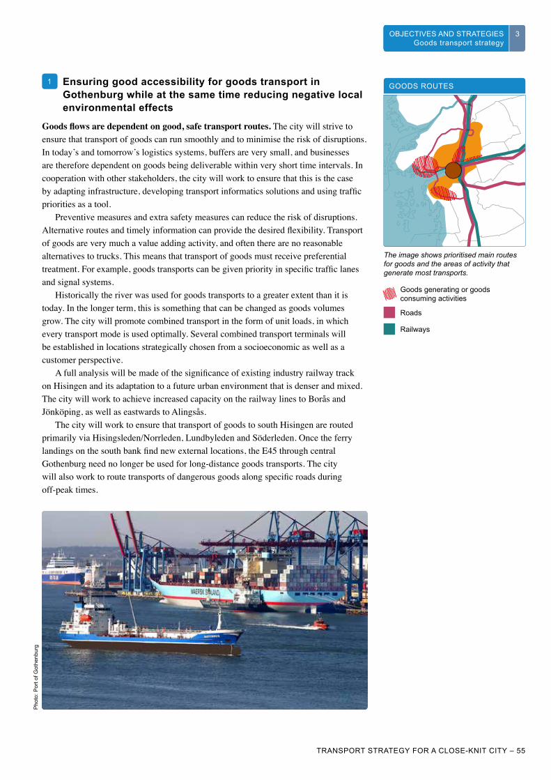
WHAT IS GOTHENBURG’S TRANSPORT STRATEGY
3
TRANSPORT STRATEGY FOR A CLOSE-KNIT CITY – 55
CHALLENGES 3OBJECTIVES AND STRATEGIESStrategy for travel
3VAD ÄR GÖTEBORGS TRAFIKSTRATEGI
3UTMANINGAR 33OBJECTIVES AND STRATEGIES Goods transport strategy
1 Ensuring good accessibility for goods transport in Gothenburg while at the same time reducing negative local environmental effects
Goods flows are dependent on good, safe transport routes. The city will strive to ensure that transport of goods can run smoothly and to minimise the risk of disruptions. In today’s and tomorrow’s logistics systems, buffers are very small, and businesses are therefore dependent on goods being deliverable within very short time intervals. In cooperation with other stakeholders, the city will work to ensure that this is the case by adapting infrastructure, developing transport informatics solutions and using traffic priorities as a tool.
Preventive measures and extra safety measures can reduce the risk of disruptions. Alternative routes and timely information can provide the desired flexibility. Transport of goods are very much a value adding activity, and often there are no reasonable alternatives to trucks. This means that transport of goods must receive preferential treatment. For example, goods transports can be given priority in specific traffic lanes and signal systems.
Historically the river was used for goods transports to a greater extent than it is today. In the longer term, this is something that can be changed as goods volumes grow. The city will promote combined transport in the form of unit loads, in which every transport mode is used optimally. Several combined transport terminals will be established in locations strategically chosen from a socioeconomic as well as a customer perspective.
A full analysis will be made of the significance of existing industry railway track on Hisingen and its adaptation to a future urban environment that is denser and mixed. The city will work to achieve increased capacity on the railway lines to Borås and Jönköping, as well as eastwards to Alingsås.
The city will work to ensure that transport of goods to south Hisingen are routed primarily via Hisingsleden/Norrleden, Lundbyleden and Söderleden. Once the ferry landings on the south bank find new external locations, the E45 through central Gothenburg need no longer be used for long-distance goods transports. The city will also work to route transports of dangerous goods along specific roads during off-peak times.
GOODS ROUTES
The image shows prioritised main routes for goods and the areas of activity that generate most transports.
Goods generating or goods consuming activities
Roads
Railways
Pho
to: P
ort o
f Got
henb
urg

56 – TRANSPORT STRATEGY FOR A CLOSE-KNIT CITY
VAD ÄR GÖTEBORGS TRAFIKSTRATEGI
3 UTMANINGAR33 OBJECTIVES AND STRATEGIES Goods transport strategy
Gothenburg will minimise the negative consequences of goods handling on people. When planning for good ease of passage, negative social and environmental consequences must be considered. Large goods flows and big workplace areas create both physical and social barriers in the city. Covering thoroughfares, breaking big workplace areas into smaller parts using pedestrian and bicycle paths, and applying a social perspective when choosing locations for new activities are examples of how the city can reduce the barrier effects of transport-intensive activities. Emissions, noise and road safety are all factors that greatly influence people’s health and sense of security, and which must therefore be given the appropriate consideration in decisions.
The port contributes to creating good conditions for business. The port is very important for businesses and activities in the city and the region. It handles sufficiently large volumes to receive direct transoceanic freight, which brings advantages for Gothenburg businesses. The city will support the port of Gothenburg so that it remains the leading port in Scandinavia and continues to take advantage of economies of scale. The port of Gothenburg is not just the city’s port – it is also of major regional and national interest. This makes it important from a national perspective as well to fulfil the needs and wishes of the port and its customers.
Transports to and from the port will be by rail to a great extent. For long (over 100 km) and heavy transports (over 3.5 tons), rail is an efficient and sustainable transport mode. Increased use of the railway also promotes ease of passage on the roads. An elevated capacity on the port line and sufficient capacity on surrounding lines are prerequisites for an efficient port.
A dynamic port also enables the development of near coastal shipping and better use of inland waterways (Göta River), both environmentally sound alternatives to road transports. The city will strive for increased investment in the goods area, in particular the development of near coastal shipping, to meet the port’s increased transport needs in the future. Incentives will be applied to encourage the use of clean vehicles, as specified for heavy trucks in Gothenburg’s clean vehicle definition, for road transports to and from the port. Gothenburg will offer favourable conditions for goods transporters, to enable them to run an efficient and sustainable operation. Good ease of passage will be complemented with good information about routes and clear alternatives in case of disruptions. Safe stands for trucks will be provided along selected routes. These add value by optimising flows and by increasing safety and security for drivers and goods. The city will also increase its use of policy instruments to raise flow efficiency. The aim is for Gothenburg to be perceived in a positive light by those who use the infrastructure, e.g. freight forwarders, hauliers and drivers, as well as by goods providers and customers.
THE PORT
The port of Gothenburg is Scandinavia’s biggest, with direct lines to 140 destinations around the globe. This makes the port Scandinavia’s foremost freight hub, and thus the gateway to the world for industry. For over four centuries, the port of Gothenburg has spread Sweden to the world and brought the world to Sweden.
TRANSPORT OF GOODS BY ROAD
Transport of goods to the port by road, and approximate proportions in respect of flows of trucks along corridors.
Pho
to: P
ort o
f Got
henb
urg
Sou
rce:
Pla
nera
för v
erks
amhe
ter,
a 20
10
repo
rt by
Got
henb
urg
City
.

TRANSPORT STRATEGY FOR A CLOSE-KNIT CITY – 57
VAD ÄR GÖTEBORGS TRAFIKSTRATEGI
3UTMANINGAR 33OBJECTIVES AND STRATEGIES Goods transport strategy
Collaborating regionally in the establishment of logistics centres and transport-intensive operations
Spatial planning and traffic control must be seen in the same context. This applies to arterial streets, access and exit roads, locations of terminals and stands. When planning new residential, industrial and green areas, the needs of goods transports will be considered in order to avoid unnecessary aims conflicts. Transport of goods stand to gain in terms of safety by being separated from other transport modes, e.g. by moving them from roads to sea or rail.
Further, the expansion needs of activities need to be met. Access to new land for new manufacturing units, warehouses and stands is decisive for the city’s and the region’s attractiveness and for the jobs supply. It is important to identify the industry’s need for expansion areas and access roads at an early stage of planning. Goods producing and goods consuming activities will be directed, by means of targeted incentives, to the city’s periphery or to specified industrial estates. Ferry terminals in the centre of the city with a large amount of lorry traffic will be moved to external locations.
Terminals will be established in locations with the possibility of rail access. They can also be established in locations where the construction of residential housing is not possible or difficult, e.g. along flight approach paths.
The environmental impact of heavy traffic must be given serious consideration when planning estates and infrastructure. Conflicts between residential housing and major industrial activity with transport of goods must be managed in the best possible way.
2
Planera för verksamheter (a 2010 report by Gothenburg City) includes important principles for planning land use.
PLANERA FÖR VERKSAMHETER- ett planeringsunderlag med vägledning för arbete med en näringslivsstruktur som ökar sysselsättningsmöjligheterna
2010
RAPPORT
Pho
to: P
ort o
f Got
henb
urg

WHAT IS GOTHENBURG’S TRANSPORT STRATEGY
3 CHALLENGES3
58 – TRANSPORT STRATEGY FOR A CLOSE-KNIT CITY
3 OBJECTIVES AND STRATEGIES Goods transport strategy
SENDSMART
Sendsmart is a Vinnova-financed collaboration project with participants from business, academic institutions and the public sector, aimed at creating sustainable transports in a urban environment.
Stimulating innovation in collaboration with academic institutions and business
Gothenburg will be at the leading edge of logistics. Gothenburg will be characterised by innovations and drive. In collaboration with academic institutions and business, the city will create innovation platforms with a well-defined process and clear targets for what the city wants to achieve, such as becoming a world leader in climate-smart goods handling. By working proactively with heavy goods transports, industrial activity will benefit both from the development of existing activities and new establishments. New thinking and increased creativity are needed in areas such as urban planning, management of transport of goods and energy-efficient transport systems. Gothenburg has very dynamic academic institutions engaged in extensive research to support the city’s strategic planning.
Gothenburg is home to several large industrial corporations within transport and logistics-related activities. The city will therefore promote and support development by initiating trial activities and offering test environments for new transport systems and encouraging development of alternative fuels and engines. Gothenburg will gain international recognition as a testing ground for efficient, climate-smart goods handling. Innovative demonstration projects will be launched, such as electrified roads for transport of goods.
Dialogue platforms. Cooperation and collaboration are prerequisites for innovation. The city will create platforms for dialogue and implementation of measures with affected stakeholders.
In order for Gothenburg to become a world leader in goods handling, the city needs to organise solution-oriented teams in which different administrations, municipal companies and even state actors take part. For cooperation with private businesses, external forums are needed that include representatives of the transport business, industry, retailing, property owners and stakeholder organisations.
3
Illus
tratio
n: S
wed
ish
Tran
spor
t Adm
inis
tratio
n
Electrification of roads for transport of goods is one way of limiting the environmental impact.

WHAT IS GOTHENBURG’S TRANSPORT STRATEGY
3
TRANSPORT STRATEGY FOR A CLOSE-KNIT CITY – 59
CHALLENGES 33OBJECTIVES AND STRATEGIES Goods transport strategy
Sou
rce:
Ren
sta
dslu
ft, th
e E
nviro
nmen
tal A
dmin
istra
tion.
Effect targets for the logistics centre of Scandinavia
Transport times and variations in transport times on road and rail to and from important industry and logistics areas do not increase, remaining in 2035 at their 2014 levels.
Ease of passage refers to the time it takes to get from one strategic point to another. Transport times directly affect the attractiveness of doing business in Gothenburg, but it is not only the time it takes to get to port, logistics and industry areas which is interesting – the variation in time is also important. An initial measurement will be made in 2014 of the major routes using the camera-based travel time systems of the Swedish Transport Administration and Gothenburg’s Urban Transport Administration, which will be complemented with data from the Swedish Transport Administration on transport times and reliability on rail to and from the port. As systems for travel time measurements are developed, it will be possible to add measurement points – including the port – and also to separate passenger traffic from goods traffic.
The impact of transport of goods on air quality, noise and acidification will be reduced to below 2014 levels.
The transport strategy does not set any targets for reducing the total volume of goods to and from Gothenburg, but it does set targets for reducing negative effects on the local environmental. Gothenburg possesses the conditions for handling goods flows both efficiently and in a climate-smart way, which is of national as well as Scandinavian interest, but this must not come at a price in terms of the city’s attractiveness and people’s health, or create barriers in the city. For a number of years now, Gothenburg has exceeded Swedish environmental quality standards, in particular the daily mean values for nitrogen dioxide at a couple of measurement points. Clean Air, A Good Built Environment and Natural Acidification Only are the three local environmental quality objectives most affected by transport of goods, in addition to Reduced Climate Impact. Air quality is continuously monitored by the Environmental Administration, and the noise surveys which began in 2013 will be carried out every three years and can be used to follow up the noise situation in the city. The focus is on stretches where people live and spend time. The Environmental Administration is also responsible for following up some of the indicators that relate to acidification.
Gothenburg will be rated the best logistics location in the Nordics in leading rankings, and will generally be regarded as a leader in climate-smart transport.
One of the leading specialist journals in logistics do an annual ranking of logistics locations in Sweden, where a number of different parameters are measured. These include research, education and access to land for expansion. Gothenburg has been topping these rankings for a long time. The rankings are studied by businesses and have an effect on decisions regarding choice of locations, for example. There is no corresponding ranking of climate-smart transports. An index is needed, which could be developed in cooperation with researchers and industry specialists.
E8
E7
NITROGEN DIOXIDE LEVELS
Distribution chart for daily mean values of nitrogen dioxide in central Gothenburg, 2011.
E9

Pho
to: i
Sto
ck P
hoto

EXAMPLES OF MEASURESStage one: Rethink Participate in research, development and trial activities in order to come up with more efficient and climate-smart transport solu-tions.
Increase knowledge about goods flows by measuring transport of goods (together with the Swedish Transport Administration on national transport networks) and investiga-tions into where goods are generated and what the destinations are.
Develop and participate in networks and other forums for goods transport issues, together with private and public actors, and create a forum for goods transport issues in the city.
Work towards a development of near- coastal shipping.
Stage two: Optimise Direct goods traffic to indicated routes using ITS solutions such as mobile applications, roadside signs and priority in signal sys-tems, as well as permission to use indicated public transport lanes at certain times.
Regulate transport of goods by truck to and from the port of Gothenburg (from Gothenburg’s environmental programme).
Prioritise goods traffic during disruptions by means of coordinated traffic control.
Stage three: Rebuild Turn the E45 cross-city thoroughfare into a municipal street once the Stena terminal has moved.
Create more secure stands for trucks in co-operation with neighbouring municipalities and the Swedish Transport Administration.
Electrify indicated goods routes through and around the city, beginning with a de-monstration project on e.g. Hisingsleden/Norrleden.
Build access and exit roads for routes by Högsbo-Sisjön industrial estate, Arendal and Volvo Torslanda.
Stage four: Build new Infrastructure investments principally in the national road and rail network, e.g.:
– the Port line
– the Rv40/E6 junction
– Hisingsleden/Norrleden (no intersections)
– new combined transport terminal

Pho
to: i
Sto
ck P
hoto

CHAPTER 4PRINCIPLES AND
SUCCESS FACTORS

WHAT IS GOTHENBURG’S TRANSPORT STRATEGY
4 CHALLENGES4
64 – TRANSPORT STRATEGY FOR A CLOSE-KNIT CITY
OBJECTIVES AND STRATEGIESStrategy for travel
4 PRINCIPLES AND SUCCESS FACTORS
4
PRINCIPLES AND SUCCESS FACTORSIn order to ensure the successful implementation of the strategies, a few important approaches or principles have been formulated. A number of success factors have been identified both within and beyond the city’s immediate area of responsibility.
IMPLEMENTATION PRINCIPLES
During most of the period up until 2035, large infrastructure projects will be ongoing in Gothenburg, while at the same time existing and new urban areas become denser and more developed. A lot will be happening in the central parts of the city. The manner in which the projects are implemented will therefore affect goal fulfilment almost as much as the transport strategy in itself: where and in what order projects are carried out, collaboration between different actors, how traffic disruptions are solved and how an uncertain external situation is handled. Four principles for guidance during the transformation of the city have therefore been formulated as a complement to the objectives and strategies.
Begin with investments that facilitate travel within, through or around the inner city
The strain on the public transport system is greatest in Gothenburg’s central areas, and the pressure is building as the number of workplaces and homes grows. The projects included in the West Sweden Agreement primarily facilitate travel to, but not within, the city. The West Link will probably lead to increased pressure on the local public transport system. For these reasons the city, in collaboration with Västra Götaland Region, must begin with investments that increase the capacity for travel in, through or around the inner city. This order of implementation also applies to later investments in ease of passage for cyclists.
P1
Four principles for how to implement the transport strategy:
Begin with investments that facilitate travel within, through or around the inner city.
Ensure that accessibility is maintained while the close-knit city is being realised.
Support innovation and the introduction of new solutions, and allow Gothenburg to be a testing ground.
Make use of the potential in a meaningful dialogue with businesses and inhabitants.
P1
P2
P3
P4

WHAT IS GOTHENBURG’S TRANSPORT STRATEGY
4
TRANSPORT STRATEGY FOR A CLOSE-KNIT CITY – 65
CHALLENGES 4OBJECTIVES AND STRATEGIESStrategy for travel
4PRINCIPLES AND SUCCESS FACTORS
4
Ensure that accessibility is maintained while the close-knit city is being realised
Even during an extended and intensive period of transformation and expansion it must be simple, reliable and safe for people and goods to get around in Gothenburg. With good information, management and control along roads, in public transport, at stops and in their hand, road users will be helped in their everyday travel. While the building projects are ongoing, quality will be maintained using the concept “mobility management during building phases”. The transport strategy’s overall priorities will apply during the building period as well, to support the long-term transformation of the transport system and lay the foundations for a new travel patterns. This means, for example, that pedestrians and cyclists will be offered short and clearly marked alternative routes, whose duration will be as long as possible. Since it may be many years before Gothenburgers can benefit from bigger, permanent improvements to the transport system, temporary solutions that can be introduced quickly are also needed. That may mean more river shuttles or a cableway across the river. An openness to temporary solutions can encourage the establishment of new technology and create positive attitudes to necessary changes to the transport system.
Support innovation and the introduction of new solutions, and allow Gothenburg to be a testing ground
There are many uncertainties in the future. Indications are that the supply of oil is limited, yet new finds are being made. Threatening effects of a warmer climate increase the need for concerted global action to reduce greenhouse gas emissions, yet no policy agreements have been reached in which countries commit themselves to really significant measures. There is a risk of more extreme weather situations going forward. These global challenges will lead to technological development as well as demands for policy measures; the uncertainty is not over whether it will happen, but rather over the speed and direction of this development. By positioning Gothenburg at the cutting edge of innovation in the traffic and transport area, and by offering the city as a testing ground, several aims are achieved. Apart from the city’s chance to reap early benefits from innovations, it can maintain and strengthen its good international reputation and give academic institutions and businesses the opportunity to work and develop at home. The city can do this by continuing to stimulate the market through innovative procurements and regulations, by making locations and routes in the city available for trial projects, and also by open-mindedly participating in and contributing to various research and development projects. With strong academic institutions and innovative businesses, Gothenburg increases its chances of getting it right as the city and transport systems of the future are shaped.
EXAMPLES OF GOOD COOPERATION
SEVS, ElectriCity, GoSmart and SendSmart are examples of ongoing projects in 2013 where business, academia and the city cooperate.
MOBILITY MANAGEMENT IN BUILDING PHASES
Mobility management in building phases aims to maintain, with the help of information, management and control, good accessibility for people and goods by influencing travel needs, choices of transport mode, times and routes. For a building phase of at least 15 years in Gothenburg, the following will apply:
• that journeys between the inner city, city areas around nodes and other key destinations are prioritised
• that pedestrians, cyclists, travellers on public transport and emergency vehicles as well as goods and distribution transports are prioritised
• that the city and other actors work proactively on temporary solutions if lead or building times become extended, if uncertainty arises over financing or licences, or if there is a risk of delays in other, related projects
• that the city maintains a close collaboration with other actors responsible for or affected by major building and infrastructure projects, and sees the overall picture from the perspective of road users
• that the city communicates with inhabitants and activities about what is going to be done, why, how it will affect road users and how best to deal with it. This will be decisive for how traffic functions during the building phase and for what the lasting effects will be.
P2
P3

WHAT IS GOTHENBURG’S TRANSPORT STRATEGY
4 CHALLENGES4
66 – TRANSPORT STRATEGY FOR A CLOSE-KNIT CITY
OBJECTIVES AND STRATEGIESStrategy for travel
4 PRINCIPLES AND SUCCESS FACTORS
4
Make use of the potential in a meaningful dialogue with businesses and inhabitants
Gothenburg is in the process of going from being a small city to a large city. With unique conditions, such as access to development land in central locations, a strong business sector and successful academic institutions, as well as the city’s strategic location in Scandinavia, this transformation has every chance of succeeding – but it will require an overall perspective. Traffic and transports interact with everything else in the city, so the transport system and its development are crucial to the successful creation of an attractive and sustainable city.
The change of planning paradigm is very clearly reflected in the transport strategy. But major changes also affect a lot of people and activities. In order to achieve the objectives of the transport strategy, residents and workers in the city must have the opportunity, by means of a broad and lively dialogue, to influence how the city implements the planned measures. They must also understand why the measures are being carried out and what new opportunities and challenges they bring. New forums and better tools for a meaningful dialogue need to be developed together with the district committees. New forums and processes for collaboration with businesses on city planning and urban development issues also need to be developed together with several of the city’s other committees and closely associated organisations.
P4
Pho
to: H
ans
Arb
y

WHAT IS GOTHENBURG’S TRANSPORT STRATEGY
4
TRANSPORT STRATEGY FOR A CLOSE-KNIT CITY – 67
CHALLENGES 4OBJECTIVES AND STRATEGIESStrategy for travel
4PRINCIPLES AND SUCCESS FACTORS
4
EXAMPLES OF ONGOING WORK
SUCCESS FACTORS FOR ACHIEVING THE OBJECTIVESIn order for the transport strategy to make a difference and contribute in the right way to the transformation of the city and its transport systems, many processes are required with many large and small decisions leading towards fulfilment of the objectives. This applies to the city’s own activities in transport planning, in other city planning committees and for other actors who influence and are influenced by each other’s processes.
Success factors for the Urban Transport Committee In order to achieve the transport strategy’s objectives and to turn its aim and direction into concrete measures, an adopted transport strategy has to lead to programmes, plans, inquiries and action. Finding a balance between studying and planning on the one hand, and carrying out concrete measures on the other is important in a situation where there is a shortage of time, money and transport planners. Finding funds is crucial for investments and for then being able to implement measures. Much of this work is already in progress, but will only be described here in terms of examples. The city’s environmental programme specifies a large number of measures that the Urban Transport Committee is responsible for and which will be implemented.
The transport strategy’s effect targets serve two main purposes: first, to specify what is to be achieved and identify effective measures, and second, to be a tool for following up the outcome of the strategies and to adjust priorities and sets of measures as necessary. The fairly small number – nine – of quantified effect targets need to be complemented with indicators that allow the organisation to pursue a development which it is more or less possible to influence, and that allows it to be proactive.
Examples of relevant indicators for Travel include travel time quotients in various relationships, car ownership and transport mode distribution in different types of areas and among different road user groups.
Examples of relevant indicators for Urban space include measurements of route efficiency, pedestrian flows, density of stays, real vehicle speed, number of street parking spaces and infrastructure share of the land area in urban environments.
Examples of relevant indicators for Transport of goods include emissions of CO2 equivalents for transports to and from Gothenburg, transport mode shares, transoceanic calls at the port, and inhabitants’ attitudes to Gothenburg’s role as Scandinavia’s logistics centre.
• Bicycle programme (ready in the spring of 2014)• Noise policy (in collaboration with the Urban Building Committee)• Guidelines for inner-city parking (in collaboration with the Urban Building Committee etc.)• Transport network plan for the centre• Target for the city transport trunk network in 2035 (in collaboration with Västra Götaland Region, Partille and Mölndal)• Railway plan for the Götaland line (Swedish Transport Administration, Gothenburg participate)
EXAMPLES OF COMING WORK
• Goods programme• Pedestrian programme• ITS programme• Operation and maintenance strategy
Success factors for the Urban Transport Committee’s continued work include:
• the drawing up in 2014 of an action plan for inquiries to be carried out over the next few years
• the drawing up of long-term investment plan and the clarification of the process it implies
• the implementation of the Environmental programme’s action plan
• a plan for following up the effect targets of the transport strategy, which also includes a set of indicators, to be drawn up in 2014.

WHAT IS GOTHENBURG’S TRANSPORT STRATEGY
4 CHALLENGES4
68 – TRANSPORT STRATEGY FOR A CLOSE-KNIT CITY
OBJECTIVES AND STRATEGIESStrategy for travel
4 PRINCIPLES AND SUCCESS FACTORS
4
Success factors within Gothenburg CityThe transport strategy assumes that the continued development of the transport systems is strongly linked to how the city itself develops, with larger numbers of residents, workers, visitors and students. Most new homes need to be built in the inner city, in central renewal areas and in designated areas for consolidation of resources, where the majority of journeys can be done with sustainable transport modes. The same applies for the majority of workplace and retail localisations. The distance to the centre is significant for the generation of car journeys, irrespective of whether densified areas have good access to public transport or not. This has been shown in several studies carried out in Sweden as well as in Norway and Denmark.
Several of the city’s urban planning actors influence goal fulfilment in the transport strategy. Their contribution is needed in order to ensure that goal fulfilment occurs with all three sustainability perspectives in balance. The city is to be built for all, and planning is to lead to increased integration. This can be done by basing the measures on social impact assessments and child impact assessments. The city must fulfil the local environmental quality objectives in an economically sustainable way. This, in turn, can be done by having many committees and companies work actively to create “near access” when establishing new public services such as preschools, schools, libraries and elderly care, so that the need for transports and travel is minimised.
In addition to the city planning committees, there are several companies within the city administration which also influence the traffic strategy’s goal fulfilment. The parking company needs to continue to actively develop parking solutions for cars and bicycles with the aim of facilitating flexible travelling. In order to fulfil the parking policy, collaboration is required with affected administrations and resources, as well as continuous work towards the objectives. The Port of Gothenburg needs to continue its adaptation process to more sustainable transport of goods and to work together with the city in order to find the most efficient and climate-smart solutions for goods handling.
Success factors within Gothenburg City include:
• that the expansion of Gothenburg follows the comprehensive plan, the River City Vision and the Development Planning Strategy
• that cooperation between city district committees and city planning committees is stepped up and that social impact and child impact assessments are used as tools
• that the other urban planning committees, including the city district committees, work actively to create “near access”
• that the Framtiden group and in particular Parkeringsbolaget continue to work in line with the parking policy
• that the Port of Gothenburg continue its adaptation process to more sustainable transport of goods in collaboration with the rest of the city.
EXAMPLES OF POSSIBLE IN-DEPTH EFFORTS
• District-specific development plans (in collaboration with city districts, the City Planning Office, the Property Management Administration and the Park and Nature Administration)• Action plan for a city without barriers• Gothenburg as a part of “the 8 million city”• Traffic parameters in Gothenburg and a transformation proposal• Strategy for handling runoff water from traffic surfaces från trafikytor
MULTI-STOREY CAR PARKS AS MEETING PLACES
A new concept which turns multi-storey car parks into meeting places to a much greater degree than they are today is being developed by Parkeringsbolaget. The company also wants to develop customer-specific solutions in which technology helps the road user increase his or her flexible travelling.
RAIL INVESTMENTS IN THE PORT
Gothenburg’s port is a world leader in the transfer of goods from trucks to trains. As part of that work, rail investments are planned for the external port area, including a combined transport terminal. Gothenburg is also working to become a transhipment port.

WHAT IS GOTHENBURG’S TRANSPORT STRATEGY
4
TRANSPORT STRATEGY FOR A CLOSE-KNIT CITY – 69
CHALLENGES 4OBJECTIVES AND STRATEGIESStrategy for travel
4PRINCIPLES AND SUCCESS FACTORS
4
Success factors beyond Gothenburg City’s immediate area of responsibilityIt is not enough for the city to act on its own in order to achieve goal fulfilment of the transport strategy. Other actors are also responsible for parts of the transport system within the city’s borders. The Swedish Transport Administration is responsible for certain roads and has an overall responsibility under the terms of its government directive. The Swedish Transport Administration also draws up the national transport plan. Västra Götaland Region is the public transport authority, responsible for all public transport in the region, and also draws up the regional transport plan. The Gothenburg Region Association of Local Authorities (GR) is also an important party, with the capacity to draw up a regional plan – a sort of comprehensive plan for the region. It is also GR which has adopted K2020, the public transport programme for the Gothenburg region.
Success factors in other actors’ areas of responsibility include:
• That the Swedish Transport Administration implements adopted and planned measures previously indicated in K2020 and within regional and national plans for transport of goods, and continues to plan and implement reinforcements of the rail infrastructure and other investments to increase sustainable travel
• That Västra Götaland Region’s, Västtrafik’s and any other actors’ investments in capacity and quality in public transport matches those investments that Gothenburg City, the regions’ other municipalities and the Swedish Transport Administration make in infrastructure, planning and prioritisation
• That the other municipalities in the labour market region contribute to commuter, business or leisure journeys to Gothenburg beginning by bus or train as early as possible, in accordance with K2020 (locally)
• That Gothenburg City be allocated regional or national funds for several important connections needed to increase capacity, shorten travel times and reduce the vulnerability of the local public transport system
• That national laws and regulations change so that cities have a bigger toolkit for their urban and transport planning, such as the possibility of establishing cycling speed areas, spaces reserved for car sharing schemes, the possibility of differentiating the congestion tax on the basis of e.g. location and vehicle type, and changed tax deduction possibilities for travel.

70 – TRANSPORT STRATEGY FOR A CLOSE-KNIT CITY
Access: Used in the transport strategy as a superordinate term to accessibility (when accessibility is defined as getting somewhere). Access to qualities such as meetings, services, food, health, recreation or work can be solved with or without (extended) journeys.
Accessibility: A measure of how easily citizens, businesses and public organisations can reach the offering and activities they need. Apart from travel time, the term covers factors such as costs, obstacles, security and access to transport modes. The term is often used specifically for the possibilities for impaired people of partaking of services, transports, environments etc.
City core: An area or place of great interest both locally and regionally. The term is based on the function that the place has in the city, but a core is typically characterised by a relatively high density and urban qualities, i.e. a mix of homes, workplaces, retail, services, culture and leisure activities that create urban life during many hours of the day and night. The comprehensive plan indicates five strategic cores, and in the transport strategy and Development Planning Strategy a further group of areas is specified as potential city cores, provided the right additions in building and measures within the transport system are made.
City distribution: Transports of goods, material etc. to and from shops, restaurants, offices and other activities and households in the centre of the city.
Core (of Gothenburg or the region): See under geographical definitions.
Cross-connections: These connect nodes, intersection points or other interchange points directly to each other, complementing radial connections which converge on the centre. They can be physical (road or rail) or functional. A fast public transport connection that comprises a detour via parts of the metro network can be more attractive than a direct line with less frequent traffic.
Cycling speed area: A street open to all types of vehicle traffic but where movement has to be with extra consideration for cyclists and at cycling speeds, i.e. 15-20 km/h. The Swedish Transport Administration has given Linköping municipality permission to carry out a cycling speed areas trial. Gothenburg got its first cycling speed area, Västra Hamngatan, in 2013.
Dense network of streets: A street structure with many intersections, leading to a more route-efficient street network with many route choices.
Destinations: In the transport strategy this term refers to places or areas where people go to do a specific errand – they could be workplaces, hospitals, shopping centres, parks, arenas etc. “Key destinations” refers to places, not fully mixed in terms of functions, to which many inhabitants of both Gothenburg and the region have reason to go.
Ease of passage: The ability to get through, for vehicles as well as for individual persons.
Effect targets: Clear, measurable targets intended for the achievement of a vision, that give concrete form to what the results will be of following a strategy, and that make it possible to follow it up. Well formulated effect targets also contribute towards identifying effective measures, and are a fundamental part of the communication in a strategic document.
Freedom of movement: The possibility of going wherever you want to without be hindered by e.g. traffic barriers.
EXPLANATIONS OF TERMS

TRANSPORT STRATEGY FOR A CLOSE-KNIT CITY – 71
The Intermediate city: See under geographical definitions.
ITS: Intelligent transport systems or transport informatics is information technology used to inform road users, to monitor, control and direct traffic – but also refers to in-vehicle systems for communication, safety etc.
K2020: Public transport programme for the Gothenburg region, adopted by the executive committee of the Gothenburg Region Association of Local Authorities in 2009. The K2020 project was a several-year collaboration between Västra Götaland Region, the Gothenburg Region Association of Local Authorities, Gothenburg City, Västtrafik and the then Road and Rail Administrations. The programme provides guide- lines and guidance for the development of public transport in the Gothenburg region.
Local labour market (labour market region): When commuting between two or more municipalities reaches a certain level, the municipalities form a local labour market in statistical terms. Today Gothenburg’s local labour market includes, in addition to the municipalities of the Gothenburg Region, Orust, Vårgårda, Bollebygd and Mark.
Metro network: A structure of public transport routes that link the city’s cores to key destinations and allows for fast, high-capacity and reliable public transport. The metro network has special priority within the trunk network for public transport, and would be called GoFast and Frequent traffic in K2020 terminology. Related to the transport strategy’s 30-minute target – that it should take no more than 30 minutes to travel between two random cores or destinations.
Mixed – use city: An urban cluster with a mixture of functions (homes, offices, retail etc.), groups of people and types of buildings.
Mobility management: A term for measures intended to influence the demand for journeys, shifting it to more sustainable transport modes.
Mobility management during building phases: Concerted measures in information, management, control and temporary traffic solutions intended to maintain good accessibility for people and goods by influencing travel needs, choices of transport mode, times and routes.
Node (in the transport strategy): Indicates intersection or interchange points that are part of the metro network. They may be part of a core or destination, or may serve as a point of entry to the metro network for those arriving by car, other forms of public transport, by bicycle or on foot, along corridors or in less dense areas with a large travel base.
Prognosis-led planning: Strategies and measures based on a trend in demand or other development. Can be seen as the opposite of target-led or predetermined planning.
Radial structure: From the centre outwards, like the spokes of a bicycle wheel. Gothenburg’s (and the region’s) public transport system (and road system) currently has a radial structure.
Robust systems: Robust here means being stable and sustainable over time. Thus a robust system can meet the city’s, its inhabitants’ and activities’ needs regardless of which of the possible scenarios is played out (within reasonable limits).
Strategic nodes: The comprehensive plan and K2020 point out four strategic nodes in Gothenburg, apart from the city centre, for the development of dense mixed-use urban environments and busy, living places: Backaplan, Frölunda Torg, Gamlestaden and Angered Centrum. The transport strategy defines these and additional areas of dense mixed-use city as cores in the city due to their function as magnets for inhabitants, visitors and activities.
K2020’S “GO” TERMS
GoAway
GoFar
GoFast
GoFrequent
GoClose
GoTo

72 – TRANSPORT STRATEGY FOR A CLOSE-KNIT CITY
Structurally imposed journeys: Journey that are necessary rather than desired, and are due to how the community is built, with e.g. a geographical division between work and home.
Testing ground: To use the city as a testing ground means giving businesses and other actors the opportunity to test innovative solutions, such as new vehicles for public transport and distribution, or autonomous cars.
Transport informatics: See ITS.
Travel time quotient: A measure of how competitive public transport is as a transport mode in relation to the car, based on travel time. A travel time quotient of less than 1.5 (travel time by public transport/travel time by car) is considered acceptable. There is a strong connection between transport mode shares and travel time quotients.
Trunk network for public transport: The high-capacity public transport system, today made up principally of tram and bus traffic within the metropolitan area, which also comprises north Mölndal and central Partille. In K2020 it is referred to as GoFrequent traffic.
Open-source data: Public actors in particular are making more and more of their databases accessible to developers of different types of services, such as content-rich digital maps.
Predetermined planning: Used as the opposite of prognosis-led planning. Predetermined, or target-led planning, instead identifies the strategies and measures that are necessary for achieving a desired future.
Urban environment: Can be defined on the basis of competition for land. When sufficient numbers of people spend time in and move around an area, the conditions for retailing, restaurants and other services that we associate with urban environments arise.
Vision: Usually expressed as a future state one wishes to attain. Does not need to fulfil formal requirements for realism, temporality or measurability.
Walking speed area: A street or square open to all types of traffic, but on pedestrians’ terms.
The West Sweden Agreement: A consolidated investment in infrastructure and other measures in and around Gothenburg. Includes the West Link train tunnel, the Marieholm tunnel, the Hisings bridge and other measures primarily aimed at increasing the capacity and quality of the public transport system.

TRANSPORT STRATEGY FOR A CLOSE-KNIT CITY – 73
PARKING POLICY
The centre
The inner city
Central Gothenburg
GR’S STRUCTURAL PROJECTION
Central Gothenburg – the inner cityCentral Gothenburg – renewal areas
The intermediate city
The outer city – future development areas
Coastal areas and the archipelago
Heavy industry, part and logistics
Nature areas
THE COMPREHENSIVE PLAN
GEOGRAPHICAL DEFINITIONSThe use of geographical terms varies slightly between documents. Below is a comparison primarily of the definitions used in the comprehensive plan, GR’s structural projection and Gothenburg’s parking policy.
The transport strategy mainly uses the definitions from the comprehensive plan, but regards them as qualitative concepts as much as geographical specifications. What we regard as the inner city today may have grown to include more than the central renewal areas by 2035. In most documents, the city centre is the area within the moat.According to the comprehensive plan, the inner city comprises the Centrum and Linnéstaden districts, or the area south of the river from Järntorget to the west, Svingeln to the east and Korsvägen to the south. The parking policy’s definition also includes Gårda and other areas.
According to the comprehensive plan, central Gothenburg is made up of the inner city and the central renewal areas on the North Bank, including Backa and Frihamnen, Gullbergsvass and south along the Mölndal stream. In 2035, this may be the inner city. In its definition of central Gothenburg, the parking policy also includes Masthugget and Majorna, among other areas. The extended inner city, as described in the Development Planning Strategy adopted in 2014, includes the central renewal areas and Majorna to the west, Guldheden in the area along the Mölndal stream to the south, and areas towards Härlanda to the east.
The central River City is the central area on either side of the river, which includes large renewal areas and is part of the adopted River City Vision.
The core, or regional core, is used as a term in GR’s structural projection and is a part of central Gothenburg that is easy to reach from the entire Gothenburg region. The area corresponds to the inner city and also includes Majorna and the North Bank, but not currently the central renewal areas.
The intermediate city is defined in the comprehensive plan as the area within the densely populated city that has good public transport (residents can reach 50 per cent of Gothenburg’s workplaces within 45 minutes). The comprehensive plan divides the intermediate city into an inner part (Majorna, Kortedala, Guldheden, Lundby etc.) and an outer part (Lövgärdet, Gårdsten etc.).
In GR’s structural projection, the metropolitan area corresponds to the intermediate city plus central parts of Mölndal and Partille.
THE RIVER CITY
THE SOUTHBANK
KVILLESTAN
FRIHAMNEN
LINDHOLMEN
THE CENTRALSTATION AREA
RINGÖN
GULLBERGSVASSGÖTARIVER
BRIDGE
BACKAPLAN
2015BEFORE
2030BEFORE
2020BEFORE
2025BEFORE
2030AFTER

74 – TRANSPORT STRATEGY FOR A CLOSE-KNIT CITY
FURTHER READINGDuring the drafting of the transport strategy, a number of dossiers and reports were produced. Grouped with these are also the provisional version of the strategy circulated for comment and the compilation of the comments received. These documents are available on the city’s website and can also be ordered in digital format from the Urban Transport Administration.
Remissversion av Göteborg 2035 – Trafikstrategi för en nära storstad (Provisional version of Gothenburg 2035 – Transport strategy for a close-knit cit) only in swedish. – including environmental, social and economic impact assessmentsSammanställning av yttranden och synpunkter (Compilation of opinions and comments) only in swedish. – a compilation of comments received on the provisional version of Gothenburg 2035 – Transport strategy for a close-knit city. Dossiers and expertreportsPrerequisites for planning available in english. – a compilation of policy documents, ongoing plans and adopted projects.Nuläge (The present situation) only in swedish. – a description of the present situation for each transport mode and an overall analysis based on selected aspects.Historisk tillbakablick (Historical retrospective) only in swedish. – a description of the development of Gothenburg’s transport system.Hur många reser i Göteborg 2035? (How many travellers in Gothenburg in 2035?) Only in swedish. – a travel analysis and comparison of transport modes choices in the national prognosis, the K2020 target and a climate-driven scenario. Updated version, autumn 2013.Spaning och trender (Outlook and trends) only in swedish. – a summary of completed in-depth analyses of future trends.Attraktiv stadsmiljö (An attractive urban environment) only in swedish. – how traffic affects and can contribute to an attractive urban environment.Kunderbjudande 2035 (Customer offer 2035) only in swedish. – what an easily accessible regional centre looks like.Dialog (Dialogue) only in swedish. – a compilation of the dialogue between the transport strategy, the Development Planning Strategy, the green strategy and the city’s district committees, as well as dialogues held with citizens in the city.Kollektivtrafik (Public transport) only in swedish. – a description of the present situation, including a shortage analysis, a draft for operations with developments according to K2020 and associated developments.Godstransporter, målbild 2035 (Goods transports, target 2035) only in swedish. – background to targets and strategies for goods transports.
TRAFIKSTRATEGI FÖR GÖTEBORGUNDERLAGSRAPPORT
NULÄGE
TRAFIKSTRATEGI FÖR GÖTEBORGUNDERLAGSRAPPORT
NULÄGE
TRAFIKSTRATEGI FÖR GÖTEBORGUNDERLAGSRAPPORT
NULÄGE
TRAFIKSTRATEGI FÖR GÖTEBORGUNDERLAGSRAPPORT
NULÄGE
TRAFIKSTRATEGI FÖR GÖTEBORGUNDERLAGSRAPPORT
NULÄGE
TRAFIKSTRATEGI FÖR GÖTEBORGUNDERLAGSRAPPORT
NULÄGE
TRAFIKSTRATEGI FÖR GÖTEBORGUNDERLAGSRAPPORT
NULÄGE
TRAFIKSTRATEGI FÖR GÖTEBORGUNDERLAGSRAPPORT
NULÄGE
TRAFIKSTRATEGI FÖR GÖTEBORGUNDERLAGSRAPPORT
NULÄGE
TRAFIKSTRATEGI FÖR GÖTEBORG
UNDERLAGSRAPPORT
NULÄGE
GöteborG 2035
trafikstrateGi för
en nära storstad

