administration of surface and ground water within colorado with the assistance of modeling mike...
TRANSCRIPT

Administration of surface and ground water within Colorado with the assistance of
modeling
Mike Sullivan, P.E. CO DWR - Deputy State Engineer
James Heath, P.E.CO DWR - Lead Modeler

Colorado Administration in the Rio Grande Basin
• Variable Water Supply• Storage (limited)• Compact Obligations/Administration• Aquifers– Confined and Unconfined Aquifers– Conjunctive use of SW and GW – Closed Basin• Use of ASR to overcome seasonal variation in SW


Rio Grande Compact

Rio Grande in Colorado

Colorado Delivery Obligations


Compact Curtailment of SW rights
• Daily administration– 10 day analysis– Daily curtailment calculation– Surface Water Users curtailed to meet daily
compact need• Example:– If have 100 cfs at Del Norte and need 20 cfs at
state line then there is 80 cfs available for diversion in Colorado.

Aquifer Systems
• Alluvial aquifers along the Rivers• Confined Aquifer underlying much of the
valley floor• Unconfined aquifer in the Closed Basin
• All are connected to stream systems and GW use can impact SW flows.

What About GW Impacts on Curtailment
• If have 100 cfs at Del Norte and need 20 cfs at state line:– Losing 10 cfs between Del Norte and the state line
due to gw use– 20 cfs must get to state line….satisfy compact first.– Only 70 cfs available for diversion by surface water
users.• We need GW users to remedy that 10 cfs that
is impacting the SW users.

Water Administration
• Administration of SW is relatively simple: If a right is being shorted you simply shut off (curtail) the most junior rights until the senior right is satisfied. Simply put: if I turn off a ditch then water will get to the senior ditch in a reasonable time for beneficial use.
• However the GW/SW interaction is not so simple. The impact on SW of GW use is attenuated, lagged, and influenced by a multitude of variables. Simply turning off a well won’t necessarily provide water to the senior right when it’s able to be beneficially used.

Need for GW Use Rules
• Statutes give the State Engineer authority to administer water. Rules explain how the State Engineer will execute that authority.– Generalities:
• If you can see the result (and statute is clear) you probably don’t need a rule-making to take action.
• If you can’t ‘see’ the result or it’s going to be difficult to administer then you probably need a rule-making to vet the process and explain it to impacted users.
• The State Engineer has promulgated GW Use Rules in the South Platte and Arkansas Basins

Need for GW Use Rules In Division 3
• Colorado law requires that we only curtail GW use to the minimum amount necessary to satisfy SW needs. Thus we can’t simply ‘turn-off’ all GW use without infringing on the rights of those users.
• To make the system equitable we need rules to require GW users to replace that injurious depletion (no more and no less) to the surface water stream.
• Difficulty: This is not a simple thin stream/alluvial system.
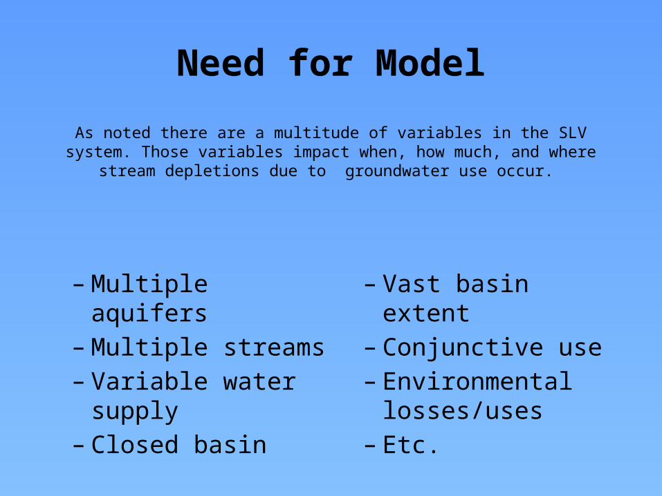
As noted there are a multitude of variables in the SLV system. Those variables impact when, how much, and where stream depletions due to groundwater use occur.
– Multiple aquifers– Multiple streams– Variable water supply– Closed basin– Vast basin extent
– Conjunctive use– Environmental
losses/uses– Etc.
Need for Model

Model/Rules
• So the model is being used to determine the impact on SW streams of GW use in various areas.
• The Rules will require remedy of those injurious impacts in order for GW use to continue.
• So…on to the RGDSS Model…..and how it will be used to inform Rules and annual operations.


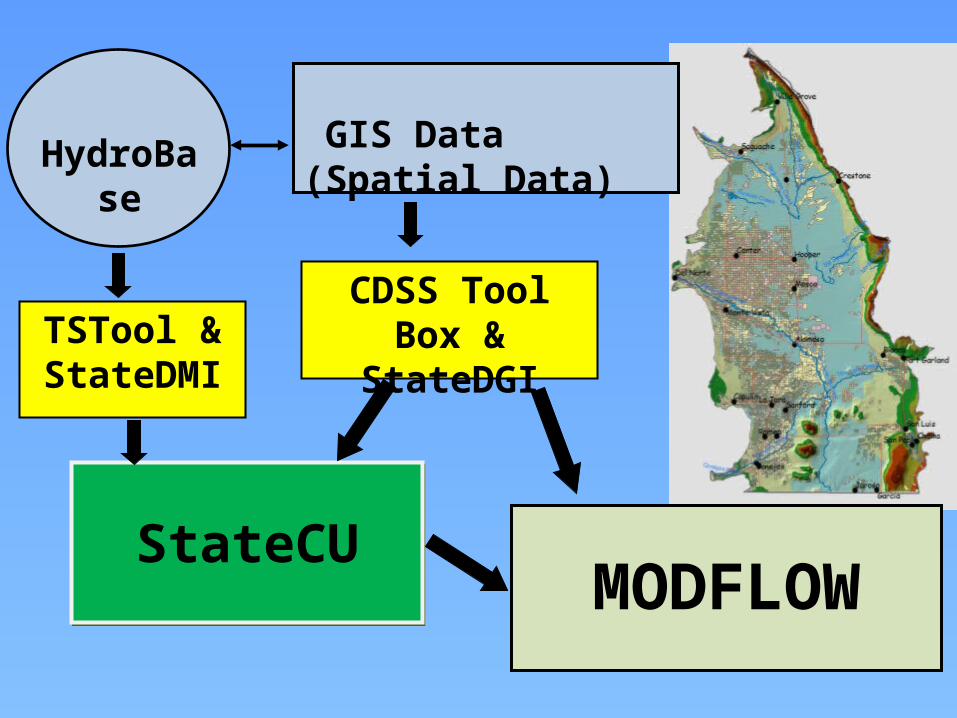
HydroBase
MODFLOW
GIS Data (Spatial Data)
TSTool & StateDMI
CDSS Tool Box & StateDGI
StateCUStateCU

Background
• San Luis Valley’s complex hydrogeology– We are continually learning


Putting the Hydrogeologic Puzzle Together
HRS Water Consultants, Inc.

Model Updates and Enhancements
• Modeling efforts prompted field work– Difficulty calibrating to observed water levels in
the San Luis Creek area based on existing understanding of the hydrogeology

Division 3Rio Grande Basin &San Luis Valley

HRS Water Consultants, Inc.

Model Updates and Enhancements
• Metered pumping data– New data available starting in 2009
HydroBase
MODFLOW
GIS Data (Spatial Data)
TSTool & StateDMI
CDSS Tool Box & StateDGI
StateCUStateCU

Stream Depletions
• So how do we use a historical model to estimate current and future stream depletions from well operations?

Map derived from Headwaters, Summer 2013
Note: Additional subdistricts could be considered. The only subdistrict currently formed is the Closed Basin (SD1). The other subdistricts are presented only as possibilities
7
POTENTIAL SUBDISTRICTS
2 Rio Grande Alluvium3 Conejos River4 Alamosa/La Jara5 Saguache Creek6 San Luis Creek7 Trinchera Creek
EXISTING SUBDISTRICT1 Closed Basin (SD1)

Response Functions
• Objectives of the Response Functions:– Simplified way to relate the operations of the
wells to Stream Depletions– Captures the essential behaviors of the RGDSS
Ground Water Model– Able to be operated by RGWCD staff, DWR staff,
and other non-modelers

Response Functions
• A.K.A. depletion factors• Calculating the response function– Run model for base condition– Run model for impact condition– Difference model runs– Express stream depletion as a fraction of increase in
consumptive use• Applying the response function– Calculate increase in consumptive use– Multiply by response function to get stream depletion


Application to Subdistrict #1
• For initial year– Use response function to determine the impacts
• For each subsequent year– Use response functions to determine the impacts
from previous year(s)– Use response functions to determine the impacts
of projected pumping on this year– Stream depletions are the sum of previous and
current year impacts


Response Function Example
• Subdistrict No. 1 ARP 2012 Submittal

Response Function Example
• What if the 2012 estimate was 50,000 af?

Response Function Example
• What if the 2012 estimate was 500,000 af?

Response Function Example
• What if 2013 and 2014 are also 500,000 af?

Map derived from Headwaters, Summer 2013
Note: Additional subdistricts could be considered. The only subdistrict currently formed is the Closed Basin (SD1). The other subdistricts are presented only as possibilities
7
POTENTIAL SUBDISTRICTS
2 Rio Grande Alluvium3 Conejos River4 Alamosa/La Jara5 Saguache Creek6 San Luis Creek7 Trinchera Creek
EXISTING SUBDISTRICT1 Closed Basin (SD1)

QUESTIONS?
Photo from Kelley Thompson

Water Division 3 Rules Resources List1. San Luis Valley Advisory Committee Website
http://water.state.co.us/SurfaceWater/RulemakingAndAdvising/SLVAC/Pages/default.aspx
2. SB04-222http://water.state.co.us/DWRIPub/San%20Luis%20Valley%20Advisory%20Committee/Tab%20C%20-%20Senate%20Bill%2004-222.pdf
3. Well Measurement Rules http://water.state.co.us/DWRIPub/Documents/div3measurementrules.pdf
4.Confined Aquifer New Use Rules http://water.state.co.us/DWRIPub/Documents/confineduserules.pdf
5.Draft Rules Governing the Withdrawal of Ground Water in Water Division 3http://water.state.co.us/DWRIPub/San%20Luis%20Valley%20Advisory%20Committee/Ground%20Water%20Rules%20for%20Division%203,%20January%2023,%202014%20Working%20Draft.pdf
6.Proposed Statement of Basis and Purpose For the Proposed Rules Governing the Withdrawal of Ground Water In Water Division Number 3
http://water.state.co.us/DWRIPub/San%20Luis%20Valley%20Advisory%20Committee/Statement%20of%20Basis%20and%20Purpose%204-29-11.pdf