‘developing our future’ · rt potential rapid transit investment/feasibility study - see rec si...
TRANSCRIPT

Argyll and Bute Structure
Plan
Argyll and Bute Structure
Plan
‘Developing Our Future’
NOVEMBER 2002
ApprovedApprovedNOVEMBER 2002
20022002

FOREWORD Argyll and Bute Council is a planning authority with statutory responsibility for preparing both a Structure Plan and Local Plans for its area. This Argyll and Bute Structure Plan, as approved and modified by Ministers, replaces the Strathclyde Structure Plan 1995 in respect of its Argyll and Bute coverage. This Structure Plan is operative from 15 November 2002. It sets out a framework for investment action and contains general land use locational strategies framing more detailed Local Plans. The statutory Development Plan for Argyll and Bute as of 15 November 2002 comprises: • this Argyll and Bute Structure Plan • the Bute Local Plan* • the Cowal Local Plan** • the Dumbarton District Wide Local Plan** • the Islay, Jura & Colonsay Local Plan* • the Kintyre Local Plan* • the Loch Lomond Local (Subject) Plan for tourism recreation and conservation# • the Lorn Local Plan* • the Mid Argyll Local Plan* • the Mull, Coll & Tiree Local Plan* *to be replaced by an Argyll and Bute Local Plan.
**to be replaced by an Argyll and Bute Local Plan and, for the constituent National Park territory, by a future Loch Lomond and the Trossachs National Park Local Plan. #to be replaced by a future Loch Lomond and the Trossachs National Park Local Plan.

Argyll and Bute Structure Plan
Developing Our Future
Pages CONTENTS Summary i – iii
Introduction 1
Strategic Issues and Investment 4 – 11
Settlement Strategy 12 – 20 Development Control 21 – 28
Topic Strategies 29 – 43 1. Coastal Planning 29 – 31
2. Agriculture and Crofting 32
3. Forestry and Woodland 33 – 34
4. Renewable Energy 35 – 36
5. Utilities, Telecommunications and Waste Management 37
6. Mineral Extraction 38 – 39
7. Transport and Access 40
8. Tourism 41 – 42
9. Housing 43
Implementation 44 – 46-

i
Argyll and Bute Structure Plan
Summary 1. This Structure Plan is a strategic land use plan comprising the following chapters:
• Introduction • Strategic Issues and Investment • Settlement Strategy • Development Control • Topic Strategies • Implementation
Introduction 2. The Introduction sets out the Overall Aims of the Plan. These include planning for
the period up to 2012 and achieving sustainable development. Strategic Issues and Investment 3. This chapter establishes economic and environmental objectives for the Plan along
with an approach to achieving these objectives in a sustainable way. Seven ‘strategic issues’ with a strong transport and access emphasis are highlighted:
i) exploiting the potential for a major timber processing inward investment and
for road to rail transhipment in the Oban to Dalmally corridor. ii) planning for the expansion of Oban along its trunk road corridor beyond its
containing land form. iii) exploiting the potential of the Firth of Clyde to be the focus for trans-Clyde
rapid transit opportunities. iv) pursuing regeneration strategies for Bute and Cowal focused on Rothesay and
Dunoon. v) planning for the special edge of conurbation circumstances of the Helensburgh
area. vi) improving the A82 Trunk Road alongside Loch Lomond and its associated links
to Clyde sea lochs. vii) promoting regeneration and economically focused initiatives for the west and
the islands and peninsular areas of Argyll and Bute, including the Kintyre Peninsula and Campbeltown.
4. In addition to the above planning issues and priorities, a number of other significant
development and transport opportunities and initiatives are presented by the Plan. Settlement Strategy 5. The Strategy presents a ten year provision of business and industrial land and a five
year provision of housing land for 14 of the 15 planning areas identified in Argyll and Bute. In addition specific consideration is given to the needs of the Helensburgh and Lomond area. Provision is focused on 11 Key Settlements as follows:

ii SUMMARY
Main Towns: Small Towns and Villages: Campbeltown Bowmore Dunoon Inveraray Helensburgh Sandbank Lochgilphead Tarbert Oban Tobermory Rothesay 6. The focus of most new development on the Key settlements will reinforce economies
of scale and support sustainable travel and transport patterns. However, other settlements and rural areas need to respond to change as well. The strategy accordingly supports appropriate forms of development at these locations within the capacity of different areas to successfully absorb development.
7. The Local Plan will detail the capacity of different areas and settlements to
accommodate further development within the context of different development control zones and the preparation of settlement plans. As part of the approach, Green Belt in the Cardross-Helensburgh-Rhu-Shandon corridor is recognised as a special and restrictive zone while the Countryside Around Settlements policy provides the framework elsewhere.
Development Control Strategy 8. This strategy contains headline policies for development within eight Development
Control Zones (a ninth zone being the Loch Lomond & Trossachs National Park which has its own separate development control regime):
1. the Main Towns 4. Countryside Around Settlements 2. the Small Towns and Villages 5. Greenbelt 3. the Minor Settlements 6. Rural Opportunity Areas 7. Sensitive Countryside 8. Very Sensitive Countryside 9. These policies are largely based on development capacity considerations and on the
planning purposes of the zones. In very broad terms the policies are founded on: 1. support for substantial development in the Main Towns. 2. support for medium scale development in the Small Towns and Villages. 3. support for small scale development within Minor Settlements. 4. support for planned development including appropriate small scale infill,
rounding-off, redevelopment and change of use to buildings within the Countryside Around Settlements.
5. acceptance of only a very restricted range of development in the Greenbelt. 6. support for small scale development in close vicinity to buildings and for small
scale open country development, but only for occasional medium or large scale development in Rural Opportunity Areas.
7. support for small scale development in close vicinity to buildings but only for
occasional open country development and for occasional medium or large scale development in the Sensitive Countryside.
SUMMARY iii
8. acceptance of only a restricted range of development which directly supports or makes appropriate use of the natural resources in the Very Sensitive Countryside.
10. Development control policies are also included to safeguard and enhance nature
conservation interests, landscape and built heritage and to address flooding and land erosion.
Topic Strategies 11. These cover a range of land use topics of particular importance to Argyll and Bute
comprising:
• Coastal Planning • Agriculture and Crofting • Forestry and Woodland • Renewable Energy • Utilities, Telecommunications and Waste Management • Mineral Extraction • Transport and Access • Tourism • Housing
Implementation 12. It is proposed to monitor progress with the Plan regularly and thoroughly. A broad
range of indicators is presented for this purpose including those relating to the achievement of sustainable development.

ARGYLL & BUTESTRUCTURE PLAN AREA
ARGYLL & BUTESTRUCTURE PLAN AREA
DIAGRAM 1
LochgilpheadLochgilpheadLochgilphead
RothesayRothesayRothesay
BowmoreBowmoreBowmore
CampbeltownCampbeltownCampbeltown
ObanObanOban
TobermoryTobermoryTobermory
DunoonDunoonDunoon
TarbertTarbertTarbert
HelensburghHelensburghHelensburgh
BUTE&
COWAL
BUTE&
COWAL
InverarayInveraray
SCOTLAND
MID ARGYLL, KINTYRE & ISLAY
OBAN, LORN & THE ISLES
BUTE&
COWALHELENSBURGH & LOMOND
COLL
TIREE
InverarayInveraray
MULL
ULVA
IONA
COLONSAY
JURA
ISLAY
BUTE
GIGHA
Inveraray
Argyll & ButeAdministrative AreaBoundaries

INTRODUCTION 1
Introduction 1.1 The Argyll and Bute Structure Plan covers the area shown on Diagram 1 (opposite). It is a strategic land use Plan set within the framework of National Planning Guidance. The Plan is intended to influence and work with partner strategies and programmes. There is a close relationship between this Structure Plan; Community Planning, Argyll and Bute Council’s Economic Development Strategy and Local Transport Strategy. Important partner agencies include the two Argyll and Bute - Local Enterprise Companies, Scottish Natural Heritage, West of Scotland Water Authority and the Scottish Environmental Protection Agency. Emerging forums, eg. local economic forums, potentially have an important role to play in furthering the aims of this Plan. 1.2 Local communities are part of this partnership. The Structure Plan is important to local communities as it helps to shape a vision for the future of Argyll and Bute and for its distinctive areas. It also sets the scene for the more detailed Argyll and Bute Local Plan and the Argyll and Bute sector of a future Loch Lomond and the Trossachs National Park Local Plan. The Overall Aims of this Structure Plan are to:
• provide a strategic land use plan for the 10 year Plan period up to 2012.
• promote appropriate planning responses to the strategic economic, environmental and land use issues facing the distinctive island, peninsular, mainland and conurbation edge areas of Argyll and Bute.
• establish and maintain a ten year supply of marketable business and industrial land and a five year supply of land for housing.
• promote ‘sustainable development’ within short- and long-term economic, social, AND environmental perspectives.
• promote the safeguarding and the enhancement of the natural and historic environment and the maintenance of biodiversity within Argyll and Bute.
• guide the preparation of the detailed Argyll and Bute Local Plan and a future Loch Lomond and the Trossachs National Park Local Plan.
1.3 Taking its lead from these Overall Aims, the Plan contains the following elements: - Explanatory text provides background, objectives and justification for the Plan.
- A Key Diagram (Diagram 2 over page) and other diagrams indicate spatial elements of the Plan.
- Tables present population projections.
- Schedules* set out lists of investment opportunities, forestry/woodland good- practise elements and the projected mineral land bank for Argyll and Bute.
- Strategic policies are labelled STRAT and are designed to promote and guide development as well as to safeguard and enhance the environment.
- Proposals are labelled PROP and concern projects and undertakings which Argyll and Bute Council is empowered itself to pursue.
- Recommendations* are labelled REC whereby Argyll and Bute Council is seeking to influence others and pursue partnership working.
*the schedules and recommendations are Council aspirations and as such are noted but not approved.

LochgilpheadLochgilpheadLochgilphead
RothesayRothesayRothesay
DunoonDunoonDunoon
HelensburghHelensburghHelensburgh
ObanObanCampbeltown
BowmoreBowmoreBowmore
InverarayInverarayInveraray
SandbankSandbankSandbank
TarbertTarbertTarbert
TobermoryTobermoryTobermory
ArdfernArdfernArdfern
ArdrishaigArdrishaigArdrishaig
BalvicarBalvicarBalvicar
BenderlochBenderlochBenderloch
BruichladdichBruichladdichBruichladdich
BunessanBunessanBunessan
CairnbaanCairnbaanCairnbaan
CardrossCardrossCardross
BunessanBunessanCarradale
Clachan SeilClachan SeilClachan Seil
Clynder/RosneathClynder/RosneathClynder/Rosneath
CraignureCraignureCraignure
DalmallyDalmallyDalmally
DervaigDervaigDervaig
DunbegDunbegDunbeg
InnellanInnellanInnellan
Kames/TighnabruaichKames/TighnabruaichKames/Tighnabruaich
Cove/KilcregganCove/KilcregganCove/Kilcreggan
Kilmichael/BridgendKilmichael/BridgendKilmichael/Bridgend
Machrihanish
Inard InardMinard
North ConnelNorth ConnelNorth Connel
PortBannatyne PortBannatyne PortBannatyne
Port CharlottePort CharlottePort Charlotte
Port EllenPort EllenPort EllenPortnahaven/Port Wemyss
RhuRhuRhu
Salen
Southend
StrachurStrachurStrachur
TaynuiltTaynuiltTaynuilt
TayvallichTayvallichTayvallich
KeillsKeillsKeills
BallygrantBallygrantBallygrant
GarelochheadGarelochheadGarelochhead
ShandonShandonShandon
Appin/Tynribbie/PortnacroishAppin/Tynribbie/PortnacroishAppin/Tynribbie/Portnacroish
ObanObanOban
ConnelConnelConnel
RT
RE
RE
RE
RE
RE
RE
*
**
*
RE
RE
RE
2
DIAGRAM 2
INTRODUCTION
RT
RT
RT
RT
RT

KEY DIARGAMKEY DIAGRAM
3INTRODUCTION
LEGEND
National Scenic Areas - see STRAT DC 8, Page 27
Very Sensitive Countryside indicative locations - detailed boundariesto be identified by the Local Plan - see STRAT DC 6, Page 26 (this includes the ‘isolated coast ’)
Countryside and Settlements comprising: - Sensitive Countryside - see STRAT DC 5, Page 25 (this includes ‘undeveloped coast ’) - Rural Opportunity Areas - see STRAT DC 4 , Page 24 - Countryside Around Settlements - see STRAT DC 2, Page 22 - Minor Settlements - see STRAT DC 1, Page 22detailed boundaries of the countryside zones and minor settlements to be identified by the Local Plan (this includes ‘developed coast’ in the vicinity ofsettlements)
Loch Lomond and the Trossachs National Park - see para 4.2, Page 21
Greenbelt restricted planning regime - see STRAT DC 3, Page 23- detailed boundaries to be identified by the Local Plan
Main Towns which are Key Settlements for employment investment - see PROP SET 1 and STRAT DC 1, Pages 16 & 22
Small Towns and Villages which are Key Settlements for employment investment- see PROP SET 1and STRAT DC 1, Pages 16 & 22
Villages - see STRAT DC 1, Page 22
Oban-Dalmally Corridor - Area of Search for Strategic TimberProcessing Inward Investment Site - see PROP SI 1. Page 6
* Oban - Significant expansion planned - see PROP SI 2, Page 6
A82 Trunk Road Improvement - see REC SI 2. Page 9
Potential Rapid Transit Investment/Feasibility Study - see REC SI 1, Page 7 RT
* Regeneration focus on Rothesay and Dunoon - see PROP SI 3, Page 8
Potential Rural Development Area designation and regeneration focus - see REC SI 3, Page 10
RE Renewable Energy focus on the West of Argyll & Bute - see REC SI 4, Page 11
*Special prescription for housing and business/industry development landprovision in the Helensburgh and Lomond planning area. This is the contextof its proximity to the Glasgow conurbation, the greenbelt zoning in theCardross/Helensburgh/Shandon corridor and the peripherality of the Rosneath Peninsula, and will have regard to the implications of the 2001 Census for this planning area - see PROP SI 4, Page 8

4 STRATEGIC ISSUES AND INVESTMENT STRATEGY
Strategic Issues and Investment
National Planning Guidance 2.1 The National Planning Policy Guidelines 1 (revised 2000) refers to objectives for the planning system. These include: enabling “sustainable development”; promoting “economic competitiveness”; supporting “social justice” and the “diverse needs of local communities”; protecting and enhancing the “quality of the environment”; promoting “good design”; and delivering “a more integrated transport system”. This Structure Plan supports these general objectives and takes them forward in the context of the strategic issues facing Argyll and Bute. Structure Plan Objectives for Argyll and Bute 2.2 The economic and social objectives of this strategic land use Plan are allied to those of Government, Argyll and Bute Council and the local enterprise companies. Objective SI 1 – Economic and Social Objectives a) to improve economic competitiveness and the relatively poor economic performance of Argyll
and Bute as a whole. b) to enhance the economic and social prospects of the geographically diverse local communities
in Argyll and Bute. c) to promote appropriate responses to the variety of challenging economic, transport-related
and planning circumstances facing these local communities. d) to treat the rich natural and historic environment of Argyll and Bute as a not fully realised
economic asset which, if safeguarded and enhanced, can stimulate further investment and increased economic activity.
2.3 Similarly, the environmental objectives of this Plan are shared with those of Government and other agencies including Scottish Natural Heritage. Objective SI 2 – Environmental Objectives a) to safeguard the diverse and high quality natural and built heritage resources, including the
abundant landward and maritime biodiversity of Argyll and Bute. b) to reinforce the strength of protection given to the European and national statutorily
protected nature conservation sites, habitats, species and built heritage sites, with which Argyll and Bute is particularly richly endowed.
c) to enhance and invest in the quality of the natural and built environment and to engage
development more effectively with this enhancement process. d) to promote a general improvement in the quality of design and encourage development of a
scale, form, and location appropriate to the character of the landscape and settlements of Argyll and Bute.
A Sustainable Approach to these Objectives 2.4 A sustainable approach to these objective can be founded on seeking out the long-term investment strengths and addressing constraints and weaknesses in local economies. Investment programmes should be aligned with strategic development and transport-related opportunities and with initiatives which can exploit these strengths and tackle some of the core weaknesses in particular areas. Protecting and enhancing the quality of Argyll and Bute’s natural and historic environment together with supporting social objectives are equally important in pursuing a sustainable approach. The following sustainable development principles should influence decision-making on land use, development, transport and infrastructure proposals:

STRATEGIC ISSUES AND INVESTMENT STRATEGY 5
1. The Win/Win Principle – considering the short- and long-term from the outset and favouring the most sustainable option; this entails safeguarding, and adding value to economies AND the environment.
2. The Biodiversity Maintenance Principle – reinforcing habitats and variety of life allied to the Local Biodiversity Action Plan and partnership process.
3. The Precautionary Principle – based on prudent avoidance and risk assessment. 4. The Polluter Pays Principle – based on natural justice and effective enforcement. 2.5 The following policy presents the overarching objectives and principles which the Council will pursue. STRAT SI 1 – SUSTAINABLE DEVELOPMENT Argyll and Bute Council shall adhere to the following principles in considering development proposals, and in its policies, proposals and land allocations in Local Plans. It will seek to: a) maximise the opportunity for local community benefit;
b) make efficient use of vacant and/or derelict brownfield land; c) support existing communities and maximise the use of existing service
infrastructure;
d) maximise the opportunities for sustainable forms of design, including energy efficiency;
e) avoid the use of prime quality or locally important good quality agricultural land; f) use public transport routes fully and increase walking and cycling networks;
g) avoid the loss of recreational and amenity open space;
h) conserve the natural and built environment and avoid significant adverse impacts on biodiversity, natural and built heritage resources;
i) respect the landscape character of an area and the setting and character of settlements;
j) avoid places where there is a significant risk of flooding, tidal inundation, coastal erosion or ground instability and
k) avoid having an adverse effect on land, air and water quality. Strategic Issues 2.6 When examining the strategic issues facing Argyll and Bute, it becomes immediately apparent that transport and accessibility are a primary consideration. However, the nature and dimension of these issues varies from one geographic area to another. These geographic areas very broadly equate with: 1. the northern and central territory of Argyll and Bute focusing on Oban, the north-
west coast, including the inner islands, and on Lochgilphead, Mid Argyll and west Loch Fyne (referred to as the ‘North’ in this Plan).
2. the various distinctive Clydeside locations and communities focusing on southern
Cowal, Dunoon, Helensburgh, the Rosneath peninsula and on Bute (referred to as the ‘South’ in this Plan).
3. the Loch Lomond and the Trossachs National Park sector which now extends
through the Argyll Forest Park up to the Clyde coast (referred to as the ‘East’ in this Plan).
4. the western Argyll islands and the Kintyre peninsula (referred to as the ‘West’ in
this Plan).

6 STRATEGIC ISSUES AND INVESTMENT STRATEGY
The North 2.7 In general terms, the competitive advantages of the North are associated with its continuing economic momentum and projected population growth. More specifically, there are strategic transport-related opportunities associated with its west coast location and with its road, rail, ferry and air service infrastructure. Oban, ‘gateway to the isles’, is an engine-room for growth but needs to expand beyond its containing landform. The road and rail corridor leading eastwards presents opportunity to compete for timber processing inward investment and to pursue timber to rail transhipment options. 2.8 Against this background, the strategic issues which should be given priority in the ‘North’ are as set out in Strategic Issues 1 and 2, along with Proposals PROP SI 1 and 2. 2.9 Strategic Issue 1: The potential for a major timber processing inward investment and for road to rail transhipment in the Oban to Dalmally corridor. PROP SI 1 – TIMBER PROCESSING INWARD INVESTMENT AND ROAD TO RAIL TRANSHIPMENT POTENTIAL The Argyll and Bute Local Plan shall, in liaison with Scottish Enterprise, incorporate areas of search or allocation for:
A) A strategic 10+ hectare inward investment site for timber processing within the Oban to Dalmally road and rail corridor.
B) Sites within the Oban to Dalmally corridor with potential for road to rail transhipment either in conjunction with or separate from A) above. 2.10 Strategic Issue 2: Planning a significant expansion of Oban beyond its currently containing land-form to meet housing and employment land requirements and to take advantage of its main trunk road and rail corridors, development road options, harbour infrastructure and potential air service development. PROP SI 2 – OBAN INVESTMENT AND EXPANSION POTENTIAL A) The Argyll and Bute Local Plan shall include a settlement plan for Oban resolving options for the phased expansion of the town including:
1. housing, business and industry development on currently allocated land and also for future expansion along the trunk road and, if feasible, along the rail corridor.
2. development opportunities at Dunstaffnage.
3. development road provision which might also fulfil relief road functions.
4. an action programme to fulfil the potential of Oban Bay and the town centre, harbour and waterfront areas for marine berthing, moorings and for commercial development allied to the various harbour, ferry and fishing interests.
B) Continue to pursue developing new air services focused on Oban, potentially servicing the wider north-west coast of Scotland as well as fragile islands such as Colonsay and Coll, and continue to safeguard development options in the vicinity of Oban Airport. 2.11 Other potential investment opportunities and initiatives for the ‘North’ are set out in Schedule 1 over:

STRATEGIC ISSUES AND INVESTMENT STRATEGY 7
SCHEDULE 1 – OTHER INVESTMENT OPPORTUNITIES AND INITIATIVES FOR THE ‘NORTH’ OF ARGYLL AND BUTE 1. Pursuance of desirability/feasibility and options study for improving ferry services and/or providing fixed
links between Luing and Seil, Kerrera and Lorn, Easdale and Ellenabeich and Lismore and north Lorn.
2. Promotion of Kilmartin Glen as a historic landscape and potential World Heritage Site including study into the potential for sympathetic development opportunities in the historic glen and adjacent Crinan Canal area.
3. Promotion of ‘action programmes’ for the town centres and waterfront at Lochgilphead and for the village harbour areas at Ardrishaig and Tarbert (including the East Loch Pier) and for the Crinan Canal.
4. Promotion of Tourism Development Areas as shown in Diagram 5, (page 42).
5. Pursuance of a study into the potential of a ‘Loch Fyne Waterway’ as a marketing tool linking with lochside settlements and marine services/facilities at Tarbert, Portavadie, Ardrishaig, Inveraray, Upper Loch Fyne, Strachur and Otter Ferry, together with the potential for land-based development and recreational opportunities in these locations.
The South 2.12 There is a diversity of community, population, transport and planning circumstances in the South. These range from conurbation edge (the Cardross-Helensburgh-Garelochhead corridor which includes a Greenbelt) to peninsular (Cowal, and Rosneath peninsulas) and island (Bute) contexts. Despite this diversity, there is a common advantage across the South arising from its accessibility to the Glasgow conurbation. The Clyde is a further unifying factor. Whilst it is a barrier to accessibility, it affords opportunities for transport and access related investment. Such investment, if it proves desirable and feasible, can reinforce the competitive capacity of bordering territories including that of neighbouring local authorities. 2.13 Within this varied geographic and planning background, the strategic issues which should be given priority in the ‘South’ are as set out in Strategic Issues 3, 4 and 5, along with recommendations and proposals REC SI 1 and PROP SI 3 and 4. 2.14 Strategic Issue 3: The potential of the Firth of Clyde to be regarded less as a barrier to accessibility and more as a ‘seaway’ offering trans-Clyde ferry and rapid transit opportunities between Clydeside towns and with Glasgow. Recommendation: REC SI 1 – TRANS-CLYDE FERRY AND RAPID TRANSIT POTENTIAL A) It is recommended that Argyll and Bute Council, in liaison with the Scottish Executive and along with the partner organisations set out in brackets below, engage or undertake feasibility studies into realising trans-Clyde rapid transit and allied ferry service potential in the Firth of Clyde with onward connection to Glasgow.
(neighbouring Councils, Local Enterprise Companies, Passenger Transport Authorities, including Westrans, the Firth of Clyde Forum and transport operators).
B) The initial brief for these feasibility studies to include:
1. securing co-operation between the relevant local authorities, transport agencies, transport operators and other marine interests in the Firth of Clyde, the Clyde Estuary and in Glasgow.
2. examining commercial viability of existing and potential services and the feasibility of extending ferry operations, including fast ferries or opening up new rapid transit passenger services across the Firth of Clyde, connecting to Glasgow or further out to western Firth of Clyde destinations.
3. stimulating and co-ordinating with economic investment, action programmes and developments, as appropriate, in the town centres and waterfronts of the Clyde-side towns.

8 STRATEGIC ISSUES AND INVESTMENT STRATEGY
2.15 Strategic Issue 4: The need to continue regeneration strategies for Bute, focused on Rothesay, and for Cowal, focused on the Sandbank-Dunoon-Toward corridor. Advantage should be taken of the inward and indigenous investment opportunities associated with the unique and high quality environment of these areas and their proximity to, and communication links with Glasgow and the central belt. Also, in the area around Dunoon, there is ‘gateway’ potential arising from the Loch Lomond and the Trossachs National Park. PROP SI 3 – REGENERATION AND ENCOURAGEMENT OF INVESTMENT FOR BUTE AND ROTHESAY AND FOR COWAL AND THE SANDBANK-DUNOON-TOWARD CORRIDOR
The Argyll and Bute Local Plan shall include provision for:
A) Housing and employment-related development land provision at appropriate locations in Rothesay and in the Sandbank-Dunoon-Toward corridor and for appropriate forms and scales of tourism-related development in the countryside; taking advantage of the investment attraction of these areas, including outward demand associated with the Glasgow conurbation and the Loch Lomond and the Trossachs National Park.
B) Action programmes to stimulate investment and enhancements in the Rothesay and Dunoon town centres and waterfronts. 2.16 Strategic Issue 5: The need to reconcile the benefits of responding positively to the conurbation and National Park edge – investment and development advantages offered by the Helensburgh area and its gateway potential, whilst constraining development to forms, scales and locations consistent with the special planning circumstances which also apply to this area. PROP SI 4 – INVESTMENT AND DEVELOPMENT IN THE CARDROSS-HELENSBURGH-GARELOCHHEAD CORRIDOR AND IN THE ROSNEATH PENINSULA
The Argyll and Bute Local Plan shall make provision in terms of appropriate scale and location for housing, employment and community facility development land where this is consistent with:
A) Preventing urban sprawl and settlement coalescence and securing a viable, long-term and managed Greenbelt in the Cardross-Helensburgh-Garelochhead corridor.
B) Realising available brownfield development opportunities and accessibility to public transport.
C) Providing a well-balanced housing profile which effectively meets affordable housing needs and width of housing choice within the area and which makes effective use of opportunities potentially arising from the disposal of surplus Ministry of Defence property.
D) Broadening local employment opportunities, as an addition to Glasgow commuter-based employment, and encouraging employment-related development which contributes to a positive vision and image for the town of Helensburgh, and Lomond.
E) Pursuing an action programme for regenerating and enhancing the Helensburgh town centre and waterfront areas.
F) Stimulating investment in the Rosneath peninsula and reducing accessibility constraints affecting this area.
G) Taking account of the Glasgow and Clyde Valley Joint Structure Plan.

STRATEGIC ISSUES AND INVESTMENT STRATEGY 9
2.17 Other opportunities and initiatives for the ‘South’ are set out in Schedule 2. SCHEDULE 2 – OTHER INVESTMENT OPPORTUNITIES AND INITIATIVES FOR THE ‘SOUTH’ OF ARGYLL AND BUTE 1. Pursuance of a feasibility study to examine the merits of extending the Argyll National Tourist Route to take
in Helensburgh. 2. Pursuance of a feasibility study to examine options for ferry services to improve accessibility to the Rosneath
peninsula. 3. Pursuance of a desirability/feasibility and options study to examine ferry services and the potential for a fixed
link between Bute and Cowal. 4. Encouraging redevelopment and new development opportunities at Portavadie to provide a mix of residential
and tourist accommodation, taking advantage of the regular ferry services to Tarbert and future upgrading of the road to Millhouse.
5. Promotion of Tourism Development Areas as shown in Diagram 5, (page 42), together with a focused study
to reveal further tourist and recreational related development opportunities (to include the potential of Ardyne Point as a strategic development opportunity for transport and tourism related uses).
The East (Loch Lomond and the Trossachs National Park) 2.18 The four aims of the National Parks (Scotland) Act 2000 are: • to conserve and enhance the natural and cultural heritage of the area • to promote sustainable use of the natural resources of the area • to promote understanding and enjoyment (including enjoyment in the form of
recreation) of the special qualities of the area by the public and • to promote sustainable economic and social development of the area’s communities 2.19 The advantages and strengths of this area are associated with its environmental quality, its National Park status and with its Government funding commitment. The strategic interests of this National Park overlap with those of Argyll and Bute. These overlapping interests include the need to protect the high quality Loch Lomond and adjacent mountain and sea loch environment, along with realising appropriate tourism, recreation and access investment opportunities while catering for the needs of the area’s communities. Further elaboration of the strategic issues and land use provision will be set out in the National Park Plan and Local Plan to be prepared by the Loch Lomond and the Trossachs National Park Authority. The National Park also presents ‘gateway’ opportunity for investment within Argyll and Bute. 2.20 Strategic Issue 6 along with recommendation REC SI 2 require priority consideration. 2.21 Strategic Issue 6: The need to improve the A82 Trunk Road, taking into consideration the strategic importance of this road in terms of its trunk road function serving major events on Loch Lomond-side and giving access to Helensburgh, the west and the north; the road not being wholly fit for these purposes particularly the section northwards of Tarbet. Recommendation: REC SI 2 – A82 TRUNK ROAD IMPROVEMENT Argyll and Bute Council and the National Park interim committee or future National Park Authority, in liaison with the Scottish Executive, consider costs and benefits and programming opportunities for further road improvements to the A82 Trunk Road. 2.22 Other aspirational or more locally based opportunities and initiatives for the Loch Lomond and the Trossachs National Park sector are set out in Schedule 3.

10 STRATEGIC ISSUES AND INVESTMENT STRATEGY
SCHEDULE 3 – OTHER INVESTMENT OPPORTUNITIES AND INITIATIVES FOR THE ‘EAST’ (THE ARGYLL AND BUTE SECTOR OF THE NATIONAL PARK)
1. To pursue further improvements to the B832/B831 roads serving Helensburgh, which is the largest town in Argyll and Bute on the edge of the National Park.
2. As part of the National Park Plan (Local Plan) process, consider the cost and benefits and opportunities for further access, tourism and recreational development within the Argyll and Bute sector, including identification and consideration of mineral reserves which may coincide with development opportunities.
3. To utilise the premier golf and other National Park recreational opportunities (including future Drumkinnon Bay facilities) to promote the wider tourist and recreational attractions of Argyll and Bute and beyond such as the West Highland Way, the Arrochar Alps, the Argyll Forest Park, and potential gateway facilities in the Helensburgh and Dunoon areas.
The West 2.23 There is a mixed picture of projected population decline and increase across the extensive and diverse territory of the West (projected decrease up to 2012 for Coll, Mull, South Kintyre and Tiree and projected increase for Colonsay, Islay, Jura and North Kintyre). Notwithstanding these projections, which should be treated with caution, all of these areas share common constraints and opportunities for the future. 2.24 These are fragile areas which share the issues of: peripherality; remoteness; agricultural restructuring; the need for regeneration throughout the area (and in Campbeltown in particular); dispersal of opportunity; and dependency on transport links and on external support. In combination, these factors operate as major constraints on the economic and social life on the islands and in the Kintyre Peninsula, the latter exhibiting many of the characteristics of an island. At the same time, these areas are endowed with considerable natural resource wealth, particularly in relation to coastal resources, wildlife and renewable energy potential. The capacity for local communities, with external support, to work productively with these resources is potentially the greatest asset of the West. This capacity requires a broader enabling process to give status, confidence and momentum to the area and its communities. 2.25 Within this challenging background, the strategic issue which should be given priority attention is set out, along with recommendations, in para 2.26 below. 2.26 Strategic Issue 7: There is an imbalance between commitments in the east of Argyll and Bute and to its fragile areas and communities to the west and in the islands. The combination of economic, geographic and dispersal factors, along with the need for regeneration and high dependency on transport links and on external support, operates as major economic and social constraints in the islands and in the Kintyre peninsula. In contrast, within these same areas there is rich natural resource wealth of international acclaim and potential for renewable energy exploitation. Recommendation: REC SI 3 – ARGYLL ISLES RURAL DEVELOPMENT AREA
A) It is recommended that Argyll and Bute Council and partner agencies, in liaison with the Scottish Executive, pursue consideration of establishing an economically focused Argyll Isles Rural Development Area designation.
B) This process could utilise, if appropriate, the existing enabling National Park legislation or expand on existing initiatives such as Initiative at the Edge and promote appropriate European responses.
C) The purpose of this process and designation is to focus on regeneration and to bring status, confidence, momentum, as well as greater economic and environmental synergy to the fragile island and Kintyre Peninsula communities; this includes the possibility of extending the process to other areas within Argyll and Bute and to neighbouring authorities along the north-western island archipelago.

STRATEGIC ISSUES AND INVESTMENT STRATEGY 11
Recommendation: REC SI 4 – RENEWABLE ENERGY INVESTMENT A) It is recommended that Argyll and Bute Council, in partnership with interested agencies and with the renewable energy industry and in liaison with the Scottish Executive, pursue renewable energy investment opportunities, particularly wind- and wave-power potential in the west of Argyll and Bute.
B) This is with a view to revealing further development opportunities of appropriate form and scale which can reinforce local economies and contribute, where feasible, to the national grid – see also Renewable Energy Strategy (pages 35-36). 2.27 Other initiatives and development and transport-related opportunities for the West are presented in Schedule 4 below. SCHEDULE 4 – OTHER INVESTMENT OPPORTUNITIES AND INITIATIVES FOR THE ‘WEST’ OF ARGYLL AND BUTE 1. The identification and promotion of a Development Opportunity Site at RAF Machrihanish which can attract
inward employment-led investment, including the possible manufacture of wind farm equipment. 2. The potential to re-establish ferry links with Ireland linking possibly to Ayrshire and with a future trans-
Clyde rapid transit operation. 3. Pursuance of a study to examine options to maintain and further develop the Coll, Tiree, Mull, Islay, Jura and
Colonsay ferry services and associated mainland ports (including intra-island services between Mull, Coll and Tiree).
4. In association with 3. above, pursue a study to examine the desirability, feasibility and options to open up a
direct mainland ferry service to Jura. 5. Promotion of ‘action programmes’ for:
a) Campbeltown town centre and waterfront; to include consideration of redevelopment areas and areas to support the expansion and attraction of Campbeltown for employment-led investment.
b) Port Ellen to uplift and stimulate investment in the village and its environs including provision for mixed use development and investment in its continuing function as a port and ferry terminal.
c) Port Askaig to provide improved transport and access facilities.
d) Tobermory to examine options and potential for further development and investment in the Tobermory Bay and waterfront areas and on the edge of the town for employment purposes.
6. Consideration of employment, housing and settlement opportunities at Glenegedale on Islay, to take advantage of its accessible location next to Islay Airport (noting that there may be opportunity to upgrade operations at Islay Airport linked with established employment bases at Bowmore/Bridgend and Port Ellen).
7. Consideration of development and employment opportunities focused on Carradale and its harbour. 8. Promotion of further work to improve the A83 Trunk Road between Lochgilphead and Kennacraig and to
uprate the A83 Campbeltown to Kennacraig section to Trunk Road status with a view to improving accessibility to Kintyre and the islands.
9. The provision of a fully upgraded road between Salen and Tobermory. 10. The continuance or commencement of desirability/feasibility studies to examine the potential benefits of
fixed links between Iona and Mull and between Coll and Tiree. 11. Promotion of Tourism Development Areas as shown in Diagram 5 (page 42).

12 SETTLEMENT STRATEGY
Settlement Strategy National Planning Guidance 3.1 The National Planning Policy Guidelines (NPPG 1 – revised 2000) on the Planning System advises that the Structure Plan should incorporate a long-term vision of at least ten years. This should be expressed as a settlement strategy for the area identifying the overall supply of land to meet the requirements for development co-ordinated with infrastructure provision. A Settlement Strategy for Argyll and Bute 3.2 A ten year supply of marketable business and industrial land and a minimum five years of land for housing is put forward for all planning areas (Diagram 3) with the exception of the Helensburgh and Lomond area (see PROP SET 4). A measured approach has been adopted for this planning area which reflects its special circumstances and relationship to the conurbation. The statistical bases in the Plan for making important decisions about future land for housing and business and industry will need to be refined over time. The approach in the Plan emphasises monitoring of development and policy. For the Helensburgh and Lomond area, existing land allocated in the adopted Local Plan will be used. Further flexibility should be available through the re-use of brownfield land and possible MOD land releases. In addition, limited new land allocations provide additional flexibility. Sites will be carefully selected so that the impact of development on the character of the area is minimised. Elsewhere in Argyll and Bute, the intention is to meet local need and, where appropriate, wider demand and thus encourage growth. The allocations will be re-examined over the whole Plan area once better statistics are available. In tune with National Planning Guidance, the Settlement Strategy builds-in a favouring of brownfield over greenfield sites. However, this brownfield weighting is not a major element of the Settlement Strategy because of the small size of Argyll and Bute settlements and the very limited supply of brownfield opportunities. 3.3 Overall the Settlement Strategy will encourage a sustainable pattern of travel by focusing employment, housing, as well as sport and recreation on the 11 Key Settlements. These Key Settlements are considered to have sufficient capacity to absorb and reconcile these land use provisions. This accords with National Planning Guidance but has an Argyll and Bute and remote rural area context. Within this context, a rigid application of urban based land use, transportation and recreation policy is inappropriate. In this regard, the development control policies of this Plan also respond favourably to small scale housing development opportunities outwith the settlements and within the capacity limits of certain areas of countryside. This is consistent with National Planning Guidance that the Structure Plan should identify limitations on development as well as areas of countryside where exceptionally new housing would be allowed. 3.4 The development land requirements for Argyll and Bute are assessed with reference to the needs and circumstances of 15 ‘planning areas’. These planning areas can be assembled up, on a best-fit basis, into the four administrative areas of Argyll and Bute Council. The exception to this, is the Loch Lomond and the Trossachs National Park sector. This is being treated as a single planning area but it sits across two administrative areas. The 15 planning areas are shown in Diagram 3 (page 14). The planning areas provide the basis for:
• assessing development land and infrastructure provision • considering mineral supply and demand • monitoring Plan performance
For the avoidance of doubt, resource distribution will not be determined by this planning area framework which has been established by this Structure Plan for land use planning purposes. 3.5 The following population projections are interim. These projections are not proposals and they are not predictions. The Council will review the projections for the planning areas using, as one reference, the 2001 Census small area results when available.

SETTLEMENT STRATEGY 13
POPULATION TABLES TABLE 1 – PROJECTED POPULATION TO 2012 FOR THE FOUR ADMINISTRATIVE AREAS
Calculations for2: 1999 2002 2007 2012 % change at 2012
Oban, Lorn & the Isles 18700 19100 19600 20000 7.0
Mid Argyll, Kintyre & Islay 21300 21200 21100 20800 -2.3
Bute & Cowal 22000 21900 21500 21000 -4.5
Helensburgh & Lomond4 27200 27800 28600 29200 7.4
Argyll and Bute 89200 90000 90800 91000 2.0
TABLE 2 – PROJECTED POPULATION1 TO 2012 FOR THE FIFTEEN PLANNING AREAS
Calculations for2: 1999 2002 2007 2012 % change at 2012
Bute 7100 6800 6300 5750 -19.0
Coll 140 140 130 120 -14.3
Colonsay 100 100 100 110 10.0
Islay 3350 3400 3500 3600 7.5
Jura 210 210 220 220 4.8
Mull 2850 2750 2560 2330 -18.2
Tiree 730 700 700 600 -17.8
Cowal 13100 13200 13400 13500 3.1
Helensburgh & Lomond4* 25800 26300 27100 27700 7.4
Inveraray 1150 1160 1200 1200 4.3
Loch Lomond & The Trossachs National Park
3050 3060 3050 3000 -1.6
Lorn & The Inner Isles 15100 15500 16300 17000 12.6
Mid Argyll 6200 6300 6450 6500 4.8
North Kintyre 2000 2050 2100 2100 5.0
South Kintyre 8400 8200 7800 7400 -11.9
Argyll and Bute3 89200 89950 90900 91100 2.1
1 Takes account of Natural Change with Migration using 1998/1999 Voluntary Population Survey Base Data. 2 These figures are rounded in the cases of a population of under 1000 to the nearest 10, in the cases where population is between
1000 and 10000 to the nearest 50 and where the population is in excess of 10000 to the nearest 100. 3 These totals deviate marginally from the corresponding totals for Argyll and Bute as projected for the four Administrative Areas
(see Table 1) due to smaller Planning Area projection base and the compounding of discrepancies. 4 These figures include the Faslane Naval Base Population. * excludes the Loch Lomond & the Trossachs National Park area.

PLANNING AREAS
LochgilpheadLochgilpheadLochgilphead
BowmoreBowmoreBowmore
ObanObanOban
TobermoryTobermoryTobermory
DunoonDunoonDunoon
BUTE
TIREE
COLL
COLONSAY
ISLAY
PLANNING AREAS
MID ARGYLL
MULL
JURA
Tarbert
14
DIAGRAM 3
InverarayInverarayInverarayInverarayInverarayInverarayInveraray
Planning Area Boundaries
Argyll & Bute AdministrativeArea Boundaries
LORN & THE INNER ISLES
INVERARAYINVERARAYINVERARAY
COWAL
NORTH KINTYRENORTH KINTYRENORTH KINTYRE
SOUTH KINTYRE
SETTLEMENT STRATEGY
IONA
GIGHA
SCARBA
ARRAN
ULVA
ORONSAY
SHUNASHUNA
LISMORELISMORELISMORE
KERERRAKERERRAKERERRA
SEILSEILSEIL
LUINGLUINGLUING
RothesayRothesayRothesay
CampbeltownCampbeltownCampbeltown
HelensburghHelensburghHelensburgh
SHUNASHUNASHUNALOCH LOMOND& THE TROSSACHS NATIONAL PARK
LOCH LOMOND& THE TROSSACHS NATIONAL PARK
LOCH LOMOND& THE TROSSACHS NATIONAL PARK
HELENSBURGH& LOMONDHELENSBURGH& LOMONDHELENSBURGH& LOMOND

SETTLEMENT STRATEGY 15
Business and Industry Land Provision in the Key Settlements 3.6 The main towns of Argyll and Bute are Key Settlements. They provide economies of scale for indigenous and inward employment-related investment. They are centres for public transport and utility infrastructure and for shopping, housing, leisure and social facilities. Along with their town centres and waterfronts, they are important components in the economic future of Argyll and Bute. As such they are a priority for development land provision, particularly for business Use Class 4 and general industrial Use Class 5 and storage distribution Use Class 6. Prioritising employment-related and housing development within these Key Settlements will also contribute, if marginally, to the Government objective of reducing car-borne travel. 3.7 The town of Helensburgh has an additional dimension of being a commuter settlement for Glasgow. This factor, whilst important, does not override its Key Settlement potential to generate and attract employment-related indigenous and possible inward investment, albeit within its wider edge of conurbation context. 3.8 There are a number of small towns and villages within Argyll and Bute which also function as Key Settlements. This reflects their significant employment-related and economic roles within their local areas. In all, there are six main towns, four small towns and one satellite village* which function as Key Settlements as follows: THE KEY SETTLEMENTS OF ARGYLL AND BUTE Main Towns:
Small Towns and Villages:
Population# Population
Campbeltown 5514 Dunoon 8384 Helensburgh 15232 Lochgilphead 2234 Oban 8234 Rothesay 5158
Bowmore 836 Inveraray 508 Sandbank* 1180 Tarbert 1312 Tobermory 896
# Voluntary Population Survey 97/98 * Sandbank provides the main allocated business and industry land for the main town of Dunoon 3.9 As with the other main Argyll and Bute settlements, Helensburgh and its neighbouring settlements require a long-term planned response to development. This should embrace brownfield and greenfield options and may, in the longer term, also require some adjustment to the Greenbelt. In the short-term the provision of a limited amount of additional land to provide some flexibility in meeting business/industry and housing needs, particularly affordable housing, will involve consideration of locations, including Green Belt, where the development impact on the character of the area will be minimal. If over the longer term, further releases of new land for development are necessary, detailed assessment and justification will be provided. Any Ministry of Defence land releases should be considered and factored into this evaluation on an ongoing basis. 3.10 In the case of Oban, its future growth requires one or more development corridors to be opened up beyond the containing landform of the town. The planning of such corridors should include sufficient business and industry land to sustain the town’s established economic momentum and its associated inward and indigenous employment related investment potential. There are two corridors, one alongside the A82(T) leading to Dunbeg, and one, for longer term consideration, bordering the railway leading to Connel. There is opportunity within both of these corridors to align the town’s future expansion with infrastructure and public transport provision. There are also options for development road provision which, potentially, can play wider traffic management roles such as relieving traffic pressure on the town centre.

16 SETTLEMENT STRATEGY
PROP SET 1 – BUSINESS AND INDUSTRY DEVELOPMENT LAND PROVISION
It is proposed that the 11 Key Settlements be prioritised for business and industry investment in Argyll and Bute in accordance with the estimated overall general provision as follows:
PLANNING AREA UNDEVELOPED PORTIONS OF PREVIOUS ALLOCATIONS
ESTIMATED NEW PROVISION TO BE ALLOCATED IN LOCAL PLAN
Cowal Sandbank 13.9 ha
Islay Bowmore 2 ha Port Ellen 0.6 ha Glenegedale
1.1 ha
5 ha
Lorn Oban 7.5 ha Oban Area Dalmally
15 ha (various sites) 10+ ha single user timber processing site
Mid Argyll Lochgilphead 3.1 ha 4.0 ha
Inveraray Inveraray 2.5 ha
Helensburgh & Lomond Helensburgh 1.2 ha Helensburgh & Lomond
2 ha
Loch Lomond and the Trossachs National Park
Arrochar 1.2 ha
Bute Rothesay 0.5 ha 1.2 ha
South Kintyre Campbeltown 3.7 ha
North Kintyre Tarbert 0.4 ha 7.5 ha
Mull Tobermory 4.0 ha
Coll
Colonsay
Jura
Tiree
Within these planning areas business and industry developments will be encouraged on suitable unallocated sites.
Retailing and Town Centres 3.11 The six main towns of Argyll and Bute* together with the Key settlements of Bowmore, Inveraray, Tarbert and Tobermory provide an important shopping focus for the planning areas in which they are located. The retailing sector is an important component of the economy and fulfils a critical role in sustaining the viability and vitality of the town centres. Land use policies which support the competitive retail market have to be balanced with the need to secure the economic integrity of town centres and to support the use of public transport. * Campbeltown, Dunoon, Helensburgh, Lochgilphead, Oban and Rothesay. 3.12 A sequential basis to retail policy is a balanced approach in tune with Government policy and forms the basis of PROP SET 2 below. A preference for retail developments over 1000m2 gross floorspace to be located in the town centres is appropriate given the limited size of the Argyll and Bute towns and their retail catchment populations.

SETTLEMENT STRATEGY 17
PROP SET 2 – RETAILING AND TOWN CENTRES The Council shall seek to sustain the viability and vitality of town centres within Argyll and Bute. A sequential approach to retail development will be adopted in accordance with national guidance. Brownfield and Greenfield Development 3.13 One of the sustainable development measures, advocated by the National Planning Policy Guidelines 1, is to promote the use of previously developed land and to minimise greenfield development. In Argyll and Bute, none of its Key Settlements has sufficient internal, previously developed land, referred to as ‘brownfield sites’, to be the sole foundation for future growth. Fortunately, they all have, to varying degrees, sufficient infrastructural and environmental capacity to successfully accommodate phased, outward expansion of business, industry and housing on to greenfield sites. Nonetheless, a favouring and phasing of development towards brownfield opportunities, where they exist, remains appropriate. PROP SET 3 – BROWNFIELD AND GREENFIELD DEVELOPMENT A) The Argyll and Bute Local Plan and constituent settlement plans shall promote and allocate development on suitable brownfield sites, if available. These shall provide for the short-term needs of the settlements, with priority given to public transport-dependant land use on such ‘brownfield’ sites.
B) The Argyll and Bute Local Plan shall otherwise support the development of ‘greenfield’ sites in accordance with the constituent settlement plans and with the varying capacity of the countryside Development Control Zones to successfully absorb small scale opportunistic housing development. Housing Land Provision 3.14 For the purposes of this Plan, housing land provision is based on projected household increases over the period to 2007 and to 2012. This provision is to be met, in the main, by formally allocated housing sites within the settlements. Additional small-scale windfall provision is supported on appropriate opportunistic unallocated sites in the settlements and in the countryside. 3.15 Allocated sites are proposed in detail by the Local Plan. This Structure Plan sets out the estimated number of housing units required in each planning area. The broad distribution between the 15 planning areas is set out in PROP SET 4. For the most part, the formally allocated housing sites will be located within or on the edge of the Key Settlements and other settlements. These are locations where, subject to restrictions in certain planning areas, there is evident need and demand for such development. The lion’s share of housing provision is at the Key Settlements where local economies of scale and concentration of employment, social facilities and public transport services are located. 3.16 The Key Settlements have a combined population of approximately 50,000 which is 56% of the total Argyll and Bute population. Other villages and minor settlements (non-key settlements) account for approximately 28,000 which is 31% of the total, leaving 13% in the countryside. Maintaining the status quo in this distribution will maintain the competitive role of the Key Settlements as the main centres for employment and population. Accordingly, the Key Settlements should continue to be the focus for allocated housing provision. This will also serve to marginally reduce car-born travel as compared to a more dispersed pattern of settlement.

18 SETTLEMENT STRATEGY
3.17 The basis of calculating the housing provision has been adapted to reflect the planning and population circumstances of four groups of planning areas: • the Loch Lomond and the Trossachs National Park – Planning Area. • the Helensburgh & Lomond – Planning Area. • the remaining planning areas with projected population increase. • the remaining planning areas with stable or projected decreasing population. Housing Provision in the Loch Lomond and the Trossachs – Planning Area 3.18 Historically in the Loch Lomond Local (Subject) Plan area there has been a particularly defensive approach to housing provision. This Structure Plan continues with this planning policy. The investment strength of this area, together with the expanded National Park territory within Argyll and Bute, is founded on the National Park status, on its conservation value and on its tourism and leisure activity. It is not founded on responding positively to mobile housing demand. Accordingly, under this Plan the housing provision should be based on meeting projected natural household growth only. A review of this position will be a matter for a future National Park Local Plan to address in conjunction with a future Argyll and Bute Structure Plan review. Housing Provision in the Helensburgh & Lomond – Planning Area 3.19 A measured approach is required. Unused Local Plan land allocations for housing were estimated at 386 units at August 2001. The estimated capacity at August 2002 is 309. This provides a range of land for housing development to meet much of the needs in the immediate future. In addition, redevelopment of brownfield land, possible further Ministry of Defence land release, and a limited amount of new land release (up to 50 units for affordable housing), provide additional flexibility. The Council will re-assess the longer-term housing provision for the Helensburgh and Lomond area in the light of new information, including the 2001 Census and in accord with current Government guidance and advice. Housing Provision in Planning Areas with Projected Significant Population Increases 3.20 These planning areas are: Cowal; Inveraray; Islay; Lorn & the Inner Isles; Mid Argyll; North Kintyre. 3.21 Within these planning areas, the housing provision has been calculated from ten year projected natural household growth plus 100% of net migration demand. A restriction on net-migration based demand is inappropriate in the remoter rural context of these planning areas. The estimated five year provision for each planning area is as set out in PROP SET 4. Housing Provision in Planning Areas with Projected Stable or Decreasing Population 3.22 These planning areas are: Bute; Coll; Colonsay; Jura; Mull; South Kintyre; Tiree. 3.23 Within these planning areas the housing provision has been based on ten year projected natural household growth. This excludes net-migration and incorporates a planning area minimum of 10-unit provision for each five-year period. The discounting of net-migration reveals the intentions of the Plan to counteract rural depopulation from these planning areas. The minimum 10-unit provision is in recognition that some island planning areas have very small populations and that no planning area should have a negative housing provision policy. In the cases of Colonsay, Jura and Tiree, a fully non-allocated housing provision is appropriate in the planning circumstances of the islands where small scale developments can meet local housing need and demand.

SETTLEMENT STRATEGY 19
PROP SET 4 – HOUSING PROVISION IN ARGYLL AND BUTE A) The overall housing provision in Argyll and Bute for the five-year period to 2007 is set out below for the planning areas with the exception of the Helensburgh and Lomond area.
B) The Council will cater for short-term housing requirements in Helensburgh and Lomond area in terms of:
• existing, unused Local Plan land allocations • units with planning consent granted subsequent to August 2001 • brownfield redevelopment • possible further Ministry of Defence land release • new land release for up to 50 affordable housing units
HOUSING LAND PROVISION IN ARGYLL AND BUTE TO 2007 AND 2012
PROVISION STRATEGY
PLANNING AREA HOUSING PROVISION TO 2007 (housing units)
Projected Natural Household Growth only.
Loch Lomond & the Trossachs National Park
26
Helensburgh & Lomond note*
Cowal 435
Inveraray 39
Islay 181
Lorn & Inner Isles 793
Mid Argyll 203
Projected Natural Household Growth + 100% of net migration
N Kintyre 66
Bute 141
S Kintyre 202
Mull 51
Coll 10
Colonsay 10
Jura 10
Projected Natural Household Growth, excluding net migration (areas where migration is negative)
Tiree 10
Note: • Where the projection is under 10, the minimum provision is 10 for each Planning Area. • The provision totals are mainly for settlement areas within each Planning Area. Additional
scope for housing may be available on appropriate countryside sites, in particular within the Rural Opportunity Areas.
*Unused local plan allocations were estimated at 386 units in August 2001. The capacity was estimated at 309 units in August 2002.

20 SETTLEMENT STRATEGY
Settlement Plans 3.24 The planning of land use in and around the towns, villages and some of the minor settlements of Argyll and Bute requires a ‘settlement plan’ to be prepared. This settlement plan will be prepared as part of the Argyll and Bute Local Plan and, for its settlements, and by a future Loch Lomond and the Trossachs National Park Local Plan. A long-term and sustainable approach, within the framework of National Planning Guidance, with community ownership and community planning, should be taken to the preparation of these settlement plans. They should be based on an assessment of the capacity of each settlement to accommodate further growth and the need thereof and seek to reconcile environmental constraints and competing provision for business, industry, housing, sport, recreation and infrastructure requirements. The basis of the settlement plans is set out in PROP SET 5 (below): PROP SET 5 – SETTLEMENT PLANS A) The Argyll and Bute Local Plan shall include settlement plans based on capacity assessments and growth needs for all of its main towns, small towns, villages and for selected minor settlements where the planning issues require a settlement plan to resolve them.
B) The settlement plans shall include appropriate five and ten year business, industry, housing, sport/recreation, and community facility Allocations. The settlement plans shall further provide a long-term perspective, where appropriate, by incorporating ‘areas of search’ for development land representing areas worthy of positive consideration for long-term settlement expansion. C) The Countryside Around Settlements zone and, for its area, the Greenbelt zone shall form the outer section of the settlement plans.

DEVELOPMENT CONTROL STRATEGY 21
Development Control 4.1 The development control policies in this Structure Plan frame the more detailed policies which will emerge in the Argyll and Bute Local Plan. There is one exception to this, and that is the development control policies which will apply to the Loch Lomond and the Trossachs National Park sector of Argyll and Bute. Loch Lomond and the Trossachs National Park 4.2 Within the boundaries of the National Park, the development control policies will be as follows. Firstly, the current adopted Local Plans (including the Loch Lomond Local (Subject) Plan 1986) until replaced, will continue to provide the development control policies for their respective National Park territory including the National Park settlements. Secondly, a future National Park – Local Plan will provide a full development control policy response for the issues affecting its Argyll and Bute sector. This regime is guided by the four aims of the National Parks (Scotland) Act 2000 – see para 2.18 (page 9). The Remaining Settlements of Argyll and Bute 4.3 For development control purposes, the remaining settlements of Argyll and Bute are categorised as: 1. the main towns 2. the small towns and villages 3. the minor settlements Settlement plans, based on capacity assessments will be prepared for each of the settlements. The Main Towns 4.4 The six main towns of Argyll and Bute are Campbeltown, Dunoon, Helensburgh, Lochgilphead, Oban and Rothesay. These are main centres of population and are Key Settlements both economically and socially. They have a general capacity to cater for small, medium and large scale development. The boundaries of the main Towns will be mapped by the settlement plans which form part of the Local Plan. These boundaries will encompass development Allocations along with infill and rounding-off areas on the edge of these settlements. Small Towns and Villages 4.5 Outwith the Loch Lomond and the Trossachs National Park sector, there are 44 small towns or villages in Argyll and Bute. They have important roles to play in sustaining the economic and social fabric of Argyll and Bute. Their capacity to absorb development successfully is often affected by their small town or village scale and setting. As such, they have a general capacity to cater only for small and medium scale development. The Argyll and Bute Local Plan will include settlement plans which map the small town and village boundaries. Minor Settlements 4.6 These are small and generally compact settlements. They range from small rural settlements which are little more than groups of houses in the countryside to more substantial settlement groups. Their common feature is that they are more ‘rural’ than ‘urban’ in character. As such they have a general capacity to cater for only small scale development. Taking six dwellinghouses as a minimum for a minor settlement, there are approximately 150 minor settlements in Argyll and Bute. The Argyll and Bute Local Plan will map the boundary of the minor settlements where and when required.

22 DEVELOPMENT CONTROL STRATEGY
STRAT DC 1 – DEVELOPMENT WITHIN THE SETTLEMENTS
Encouragement shall be given, subject to capacity assessments, to development in the settlements as follows:
A) Within the Main Towns to development serving a wide community of interest, including large scale development*, on appropriate infill, rounding-off and redevelopment sites.
B) Within the Small Towns and Villages to development serving a local community of interest, up to and including medium scale development*, on appropriate infill, rounding-off and redevelopment sites; in exceptional cases large scale development may be supported.
C) Within the Minor Settlements to small scale development* which is compatible with an essentially rural settlement location on appropriate infill, rounding-off, and redevelopment sites; in exceptional cases medium or large scale development may be supported.
D) Developments which do not accord with this policy are those outwith A), B) and C) above and urban bad neighbour developments which are essentially incompatible with the close configuration of land uses found in settlements eg. mineral extraction development or development which results in excessively high development densities, settlement cramming** or inappropriate rounding-off on the edge of settlements.
E) Developments in settlements are also subject to consistency with the other policies of this Structure Plan and in the Local Plan.
* small, medium and large scale development - to be defined in the Local Plan and, in the case of housing, small scale corresponds to developments not exceeding 5 dwelling units, medium scale to development of between 6 and 30 dwelling units inclusive and large scale to development exceeding 30 dwelling units. **settlement cramming – over developing valuable open space within settlements. Countryside Around Settlements 4.7 These countryside areas experience variable development pressure depending on the function of the settlements and their success in attracting investment, development and population. In most cases these peripheral countryside areas can successfully absorb development providing it is planned for and co-ordinated by a settlement plan. This co-ordinated approach can normally accommodate planned developments as well as limited housing development on croft lands and small scale development taking place opportunistically on infill, rounding-off, redevelopment and change of use of building sites. The settlement plans, which form part of the Local Plan, will map the boundaries of the Countryside Around Settlements zone. STRAT DC 2 – DEVELOPMENT WITHIN THE COUNTRYSIDE AROUND SETTLEMENTS
A) Within the Countryside Around Settlements encouragement shall be given to development which accords with the settlement plan for the area; this includes appropriate small scale* infill, rounding-off, redevelopment, change of use of building development and single dwellinghouses on bareland crofts or single additional dwellinghouses on individual crofts subject to consistency with STRAT AC 1 C). In special cases, a locational need or exceptional circumstance may justify a development.
B) Developments which do not accord with this policy are those outwith category A) above and development which will erode the setting of settlements or result in undesirable forms of ribbon development or settlement coalescence or result in the undesirable break-up of croft land assets.
C) Developments are also subject to consistency with other policies of the Structure Plan and in the Local Plan.
* to be defined in the Local Plan and in the case of housing, developments not exceeding 5 dwelling units.
DEVELOPMENT CONTROL STRATEGY 23
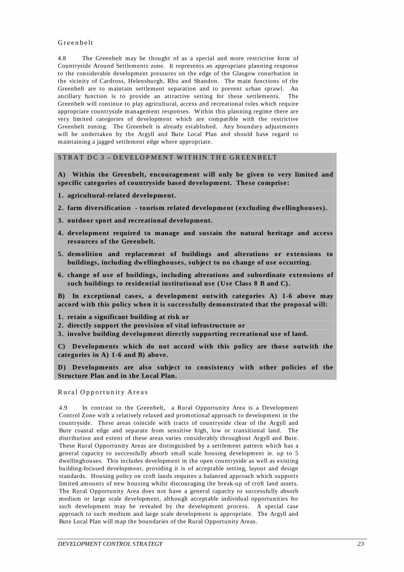
Greenbelt 4.8 The Greenbelt may be thought of as a special and more restrictive form of Countryside Around Settlements zone. It represents an appropriate planning response to the considerable development pressures on the edge of the Glasgow conurbation in the vicinity of Cardross, Helensburgh, Rhu and Shandon. The main functions of the Greenbelt are to maintain settlement separation and to prevent urban sprawl. An ancillary function is to provide an attractive setting for these settlements. The Greenbelt will continue to play agricultural, access and recreational roles which require appropriate countryside management responses. Within this planning regime there are very limited categories of development which are compatible with the restrictive Greenbelt zoning. The Greenbelt is already established. Any boundary adjustments will be undertaken by the Argyll and Bute Local Plan and should have regard to maintaining a jagged settlement edge where appropriate. STRAT DC 3 – DEVELOPMENT WITHIN THE GREENBELT A) Within the Greenbelt, encouragement will only be given to very limited and specific categories of countryside based development. These comprise:
1. agricultural-related development.
2. farm diversification - tourism related development (excluding dwellinghouses).
3. outdoor sport and recreational development.
4. development required to manage and sustain the natural heritage and access resources of the Greenbelt.
5. demolition and replacement of buildings and alterations or extensions to buildings, including dwellinghouses, subject to no change of use occurring.
6. change of use of buildings, including alterations and subordinate extensions of such buildings to residential institutional use (Use Class 8 B and C).
B) In exceptional cases, a development outwith categories A) 1-6 above may accord with this policy when it is successfully demonstrated that the proposal will:
1. retain a significant building at risk or 2. directly support the provision of vital infrastructure or 3. involve building development directly supporting recreational use of land.
C) Developments which do not accord with this policy are those outwith the categories in A) 1-6 and B) above.
D) Developments are also subject to consistency with other policies of the Structure Plan and in the Local Plan. Rural Opportunity Areas 4.9 In contrast to the Greenbelt, a Rural Opportunity Area is a Development Control Zone with a relatively relaxed and promotional approach to development in the countryside. These areas coincide with tracts of countryside clear of the Argyll and Bute coastal edge and separate from sensitive high, low or transitional land. The distribution and extent of these areas varies considerably throughout Argyll and Bute. These Rural Opportunity Areas are distinguished by a settlement pattern which has a general capacity to successfully absorb small scale housing development ie. up to 5 dwellinghouses. This includes development in the open countryside as well as existing building-focused development, providing it is of acceptable setting, layout and design standards. Housing policy on croft lands requires a balanced approach which supports limited amounts of new housing whilst discouraging the break-up of croft land assets. The Rural Opportunity Area does not have a general capacity to successfully absorb medium or large scale development, although acceptable individual opportunities for such development may be revealed by the development process. A special case approach to such medium and large scale development is appropriate. The Argyll and Bute Local Plan will map the boundaries of the Rural Opportunity Areas.

24 DEVELOPMENT CONTROL STRATEGY
STRAT DC 4 – DEVELOPMENT IN RURAL OPPORTUNITY AREAS A) Within Rural Opportunity Areas encouragement shall be given to small scale developments* on suitable sites which, in terms of siting and design, will visually integrate with the landscape and settlement pattern; this may include small scale development in the open countryside as well as small scale infill, rounding-off, redevelopment and change of use of building development.
B) On individual crofts housing development shall be limited to a single dwellinghouse on a bareland croft or a single additional dwellinghouse and is subject to consistency with STRAT AC 1 C).
C) In special cases, a medium or large scale development** may be supported if this accords with an area capacity evaluation# which demonstrates that the specific development proposed will integrate sympathetically with the landscape and settlement pattern and will entail or result in at least one of the following outcomes:
1. a positive development opportunity yielding significant countryside management or environmental enhancement benefit, or building retention benefit, or local community benefit, or economic benefit OR
2. a development with a locational need to be on or in the near vicinity of the proposed site.
D) Developments which do not accord with this policy are those outwith categories A), B) and C) above and those with incongruous and unacceptable siting and design characteristics, including development resulting in undesirable forms of ribbon development or settlement coalescence.
E) Developments are also subject to consistency with other policies of the Structure Plan and in the Local Plan.
* to be defined in the Local Plan and in the case of housing, corresponding to developments not exceeding 5 dwelling units ** see foot of STRAT DC 1 (page 22) # area capacity evaluation - this is an assessment undertaken by the planning authority to establish the capacity of the wider countryside area containing the application site to successfully absorb development (this wider area may be the whole or part of the Development Control Zone or an ‘area of common landscape character’ containing the site). Sensitive Countryside 4.10 This Development Control Zone corresponds to most of the coastal perimeter of Argyll and Bute and to transitional areas between low and high ground. It also embraces sensitive inland areas such as associated with the more substantial low-lying freshwater lochs. The sensitivities within this zone can vary considerably. The essential difference between the Sensitive Countryside and the Rural Opportunity Area is that the Sensitive Countryside does not have a general capacity to successfully absorb development in the open countryside whilst the Rural Opportunity Area does. The only locations within the Sensitive Countryside with a general capacity to successfully absorb development are where there are opportunities for sympathetic small scale infill, rounding-off, redevelopment or change of use of building development. Where open country opportunities reveal themselves through the development process, then a special case approach is appropriate. This includes a balanced approach of supporting limited amounts of new housing on croft lands whilst discouraging the break up of croft land assets. The Argyll and Bute Local Plan will map the boundaries of the Sensitive Countryside zones.

DEVELOPMENT CONTROL STRATEGY 25
STRAT DC 5 – DEVELOPMENT IN SENSITIVE COUNTRYSIDE A) Within Sensitive Countryside encouragement shall only be given to small scale* infill, rounding-off, redevelopment and change of use of building development or to single dwellinghouses on bareland crofts or single additional dwellinghouses on individual crofts subject to consistency with STRAT AC 1 C).
B) In special cases, development in the open countryside and medium or large scale development may be supported if this accords with an area capacity evaluation# which demonstrates that the specific development proposed will integrate sympathetically with the landscape and settlement pattern and that the development will entail or result in at least one of the following outcomes:
1. a small scale housing development which accords with the area capacity evaluation# OR
2. a positive development opportunity yielding significant countryside management or environmental enhancement benefit, or building retention benefit or local community benefit or economic benefit OR
3. a development with a locational need to be on or in the near vicinity of the proposed site.
C) Developments which do not accord with this policy are those outwith categories A) and B) above and those with incongruous siting, scale and design characteristics or resulting in unacceptable forms of ribbon development or settlement coalescence.
D) Developments are also subject to consistency with other policies of the Structure Plan and in the Local Plan.
* to be defined in the Local Plan and, in the case of housing, corresponding to development not exceeding 5 dwelling units. # area capacity evaluation - see note at foot of STRAT DC 4. Very Sensitive Countryside 4.11 This Development Control Zone corresponds to the countryside and coastal areas which are very vulnerable to adverse development impact and which have extremely limited capacity to successfully absorb development. This includes the wild and remote coasts of Argyll and Bute (equivalent of the ‘Isolated Coast’ in National Planning Guidance). It also includes upland and mountain areas and can embrace low-lying ground which contains extensive and concentrated conservation interests. Within this zone, the quality, sensitivity and extent of the natural heritage resources is such that development requires strict control and land use requires particularly careful management. Development is considered generally to be incompatible with this Very Sensitive Countryside unless it is sympathetically focused on existing buildings and land use or is directly associated with the natural resources of the area. The natural resources within these areas which, subject to very careful site selection, may successfully support specific development opportunities include: agriculture and forestry land; wind energy; and high ground for telecommunications and specialist tourist activity. Such opportunities, however, require to be revealed by thorough environmental assessments including the identification of development capacity thresholds and alternative location options. The Argyll and Bute Local Plan will map the boundaries of the Very Sensitive Countryside zone.

26 DEVELOPMENT CONTROL STRATEGY
STRAT DC 6 – DEVELOPMENT IN VERY SENSITIVE COUNTRYSIDE A) Within the Very Sensitive Countryside encouragement will only be given to specific categories of development on well chosen sites. These comprise:
1. renewable energy related development which is supported by policies STRAT RE 1 and 2.
2. telecommunication-related development.
3. development directly supporting agricultural, forestry, nature conservation or other established use activity.
B) In exceptional cases a development with a locational need or directly providing a specialist tourist facility may be supported.
C) Developments which do not accord with this policy are those outwith categories A) and B) above and those with incongruous and unacceptable siting, scale and design characteristics including development which breaches the overall carrying-capacity of the wider landscape, coastscape and natural environment.
D) Developments are subject to consistency with other policies of the Structure Plan and in the Local Plan. The Introduction of the Development Control Zones 4.12 It can be determined now whether or not a development is located within a settlement or Greenbelt. Accordingly STRAT DC 1 and 3 become operative upon the approval of this Structure Plan. In the case of STRAT DC 2, 4, 5 and 6, however, these policies will become operative only once the Argyll and Bute Local Plan has mapped these zones and reaches the stage when it is a material planning consideration. In the meantime, the current adopted Local Plan policies will continue to apply to the countryside areas outwith the settlements and Greenbelt. Nature Conservation and Development Control 4.13 Nature conservation designations are likely to contain key environmental features which are vulnerable to adverse development impact and land use change. In most instances, there is a close association between the key environmental features which require to be safeguarded and the actual protected area of the formal designation. In other cases, the relationship between the designation boundary and the nature conservation interest is more loosely formed and relates to specific features within or extending beyond the designated area. Nature conservation designations range from internationally important statutory sites eg. Natura 2000 Sites – to nationally important statutorily protected sites eg. Sites of Special Scientific Interest – to more local non-statutory designations eg. Local Wildlife Sites. 4.14 In the case of non-statutory designations, the process of protecting these interests is often associated with a reaction to a particular development proposal. Here, the strength of protection depends on the balance of short- and long-term economic, social and environmental implications of the development. On the other hand, in the case of statutorily protected nature conservation interests, there is added strength of protection, particularly when natural resources of international or national acclaim are involved. Here, the strength of protection is heavily and properly weighted towards the nature conservation interest and is backed up by referral process. If development is considered to damage these statutorily protected nature conservation interests, then the development should be viewed as being non-sustainable, unless there is a counter-balancing support for the proposal on social or economic grounds of national importance. These considerations are the basis of STRAT DC 7 (over).

DEVELOPMENT CONTROL STRATEGY 27
STRAT DC 7 – NATURE CONSERVATION AND DEVELOPMENT CONTROL A) Development likely to have a significant effect on a Natura site will be subject to an appropriate assessment. The development will only be permitted where the assessment indicates that it will not adversely affect the integrity of the site, or, there are no alternative solutions and there are imperative reasons of overriding public interest.
B) On sites of national importance, SSSIs and NNRs, development will only be permitted where it can be demonstrated that the overall objectives of the designation and the overall integrity of the designated area would not be compromised, or where any adverse impacts are clearly outweighed by social or economic benefits of national importance.
C) Development which impacts on Local Wildlife Sites or other nature conservation interests, including sites, habitats or species at risk as identified in the Local Biodiversity Action Plan, shall be assessed carefully to determine its acceptability balanced along with national – or local – social or economic considerations.
D) Enhancement to nature conservation interests will also be encouraged in association with development and land use proposals. Landscape and Development Control 4.15 There is a wide variety of distinctive landscapes and coastscapes in Argyll and Bute, some of the highest quality. All of these landscapes should be regarded, to one degree or other, as special and development be required to visually integrate with their key features including those relating to settlement pattern. However, different landscapes have variable capacities to successfully absorb different forms and scales of development. Landscape character assessment will be useful in the consideration of development proposals in the countryside. 4.16 These factors require a careful capacity-based approach to development impact on the landscape. Whilst this involves ongoing assessments, it is recognised that studies already undertaken, such as the Scottish Natural Heritage Landscape Assessment of Argyll and the Firth of Clyde provide useful background information. It is further recognised that National Scenic Areas contain scarce and highly valuable landscapes which are of national significance. These National Scenic Areas, therefore, require particularly careful consideration and added protection. This is the basis of STRAT DC 8. STRAT DC 8 – LANDSCAPE AND DEVELOPMENT CONTROL A) Development which, by reason of location, siting, scale, form, design or cumulative impact, damages or undermines the key environmental features of a visually contained or wider landscape or coastscape shall be treated as ‘non-sustainable’ and is contrary to this policy. Outwith the National Park particularly important and vulnerable landscapes in Argyll and Bute are those associated with:
1. National Scenic Areas
2. Historic landscapes and their settings with close links with archaeology and built heritage and/or historic gardens and designed landscapes.
3. Landward and coastal areas with semi-wilderness or isolated or panoramic quality.
B) Protection, conservation and enhancement to landscape will also be encouraged in association with development and land use proposals.

28 DEVELOPMENT CONTROL STRATEGY
Historic Environment 4.17 There is a wealth of archaeology, scheduled monuments, listed buildings and conservation areas in Argyll and Bute. Despite this wealth of resource, the general quality of the built environment varies considerably. In the countryside and on the edge of settlements the highest quality tends to be where the built environment components subtly merge with the landscape elements eg. as with the historic and designed landscapes. The premier historic landscape in Argyll and Bute is Kilmartin Glen (of potential World Heritage status). In the settlements, the significance of the historic environment is founded on history, culture and on the quality of buildings, settings, layouts, and streetscapes. The premier conservation settlement in Argyll and Bute is Inveraray which is a major tourist destination. 4.18 As with nature conservation and landscape interests, there is a hierarchy of importance associated with historic environment. This hierarchy incorporates statutory protection and, in the case of conservation areas and listed buildings, a basic grading system. The strength of protection is proportionate to the importance of this built heritage and should be reflected in planning policy. At the same time, there is a need to enhance the quality of the resource as well as to respond positively to modern needs, innovation and change. This requires a sensitive, balanced and proportionate approach which is the intention of STRAT DC 9. STRAT DC 9 – HISTORIC ENVIRONMENT AND DEVELOPMENT CONTROL Protection, conservation, enhancement and positive management of the historic environment is promoted. Development that damages or undermines the historic, architectural or cultural qualities of the historic environment will be resisted; particularly if it would affect a Scheduled Ancient Monument or its setting, other recognised architectural site of national or regional importance, listed building or its setting, conservation area or historic garden and designed landscape. More detailed policy and proposals for the historic environment will be set out in the Local Plan. Flooding and Land Erosion 4.19 National Planning Guidance advises that flooding liability is a ‘material planning consideration’. Planning authorities are advised to form flood appraisal groups whilst identifying areas subject to risk from flooding and areas where the threat might be managed. This will be taken forward in the Argyll and Bute Local Plan along with land erosion which is also an issue in Argyll and Bute. STRAT DC 10 presents the basic criteria which development must satisfy in this regard. STRAT DC 10 – FLOODING AND LAND EROSION Proposed development which would be at significant risk of flooding or from erosion, or which would increase the risk to other land and property, or occupy the functional flood plan, will not be in accord with the structure plan. In some places, where it is feasible to manage the threat, suitable mitigation or other measures may be possible.

COASTAL PLANNING STRATEGY 29
TOPIC STRATEGIES
1. Coastal Planning 5.1 Coastal planning is a particularly important aspect of planning in Argyll and Bute. The objective for this coastal planning is set out below: Objective CP 1 – Coastal Planning To fully harness the productive capacity of Argyll and Bute’s ‘economic coast’ allied to safeguarding its unique qualities and working on a sustainable basis within its environmental and recreational capacity. 5.2 Government has stressed the importance of coastal planning. The National Planning Policy Guidelines 13 – Coastal Planning seeks planning responses which are appropriate for ‘isolated coast’, ‘developed coast’ and ‘undeveloped coast’. The equivalent of these coastal divisions are to be incorporated into the Development Control Zones as follows: 1. the ‘isolated coast’ which is generally wild and remote with very limited capacity
for development coincides with the coastal sections of the Very Sensitive Countryside zone.
2. the ‘developed coast’ is equivalent to the towns, villages and minor settlement –
coastal edges together with the coastal sectors the Countryside Around Settlements and Greenbelt zones.
3. the ‘undeveloped coast’ is coincident with the coastal sectors of the Sensitive
Countryside zone which is intermediate between 1 and 2 above. Coastal Framework Plans 5.3 Coastal framework plans can be a type of non-statutory partnership plan which extends over matters beyond planning control. It can be an important mechanism for informing and guiding activity and development in and around the Argyll and Bute coast. 5.4 A central purpose of a coastal framework plan will be to refine and resolve: 1. planning policy relating to development along landward and seaward sectors of the
coast; these refinements can be incorporated into the Structure Plan and Local Plan review process.
2. the environmental and carrying-capacity of competing land and water uses and the
identification of priority users and activities. 3. coastal zone management guidelines embracing: area management agreements;
eco-system management; coastal protection and nature conservation interests; fin-fish and shell-fish farming; wild fish and angling interests; new frontier aquaculture; coastal transport and access issues; tourism and recreation potential including yachting and boating interests; and residential amenity considerations.
5.5 Recommendation CP 1 (over) sets out recommendations for partners to seek resources and to commence and prioritise the preparation of such coastal framework plans in and bordering Argyll and Bute.

30 COASTAL PLANNING STRATEGY
Recommendation: REC CP 1 – COASTAL FRAMEWORK PLANS A) It is recommended that Argyll and Bute Council, with support from Scottish Environmental Protection Agency, Scottish Natural Heritage, the local enterprise companies, neighbouring authorities, other partner and community organisations and interest groups, commence and seek to complete within five years the following priority coastal framework plans.
1. Firth of Lorn/Lynn of Lorn/Loch Linnhe/South of Mull waters 2. Islay, Jura and Colonsay coastal waters 3. Firth of Clyde (Firth of Clyde Forum already established) 4. Loch Etive 5. Loch Creran 6. Sound of Mull 7. Loch Fyne
B) It is further recommended that Coastal Forums and tripartite working groups* be resourced, organised and utilised to pursue and realise the purposes of these coastal framework plans. * such as the tripartite working group comprising the Scottish Executive Rural Affairs Department and the salmon farming industry (including constituent and amalgamated Fishery Boards) and wild fish interests. Coastal Transhipment 5.6 One of the economic assets of the Argyll and Bute coast is its potential for coastal transhipment. This potential relates particularly to timber transhipment. There are substantial areas of the Argyll and Bute coast which has a general capacity to successfully absorb coastal transhipment facilities. These considerations underpin STRAT CP 1. STRAT CP 1 – COASTAL TRANSHIPMENT DEVELOPMENT Coastal transhipment development on well chosen sites will be supported unless it is incompatible with:
A) A particular settlement or edge of settlement location because of conflict with the settlement plan or with the capacity of that settlement to accommodate the development.
B) A particular coastal location because of the sensitivities of the coastscape or coastal ecology or significant conflict with other coastal use or natural heritage interest. Aquaculture 5.7 Fish farming and commercial sea-fishing have been experiencing substantial pressures and change. At the heart of these pressures have been issues of sustainable stock management; carrying-capacity; environmental-capacity; fish disease transmission; evolving technologies; new frontiers in aquaculture opening up; international competition; and local community impact. Planning arrangements and jurisdiction has also been subject to change with planning control potentially extending to cover marine fish farming. Within this changing picture, various factors have to be balanced in order to achieve sustainable fish farming, sea-fishing industries and angling. These factors are to be taken forward in the Argyll and Bute Local Plan in accordance with PROP CP 1 (over page).

COASTAL PLANNING STRATEGY 31
PROP CP 1 – AQUACULTURE AND DEVELOPMENT CONTROL A) The Argyll and Bute Local Plan shall include appropriate policies relating to shell-fish and fin-fish farming.
B) The policies will accord with the principles and categories contained in “Locational Guidelines for the Authorisation of Marine Fish Farms in Scottish Waters”, issued by the Scottish Executive. Sea-Fishing Interests 5.8 The following recommendation REC CP 2 is made in order to address land use and ecological concerns relating to depleted fish stock and sustainable sea-fishing. Recommendation: REC CP 2 – SEA-FISHING INTERESTS A) It is recommended that Argyll and Bute Council, along with partner agencies and organisations, take into account local commercial fishing interests when Argyll and Bute Local Plans or partnership processes propose harbour and waterfront-related development and projects.
B) Local commercial fishing interests be given appropriate support to achieve a local fishing – and local community-based approach to sustainable sea-fishing having regard to:
1. international and national competition for depleted fish stocks.
2. consequential adversities in the communities and settlements which support and depend on local commercial fishing fleets.
3. pursuance of more control of in-shore waters by local communities and the pursuance of ‘conservation order’ approaches.
4. establishing recovery regimes and management of over-fished sea-lochs.

32 AGRICULTURE AND CROFTING STRATEGY
2. Agriculture and Crofting 6.1 Agriculture is a primary industry which is marginalised and undergoing structural change imposed largely by external factors. It is a local industry, however, which will continue to play a long-term and crucial role in sustaining rural community life and the environment of Argyll and Bute. This role, which has a dynamic as well as a stabilising force, is rooted in the working and management of land. Rural development is part of this land management process. The land itself is a primary natural resource and agriculture, crofting and estate infrastructure should be utilised in imaginative and sustainable ways to add value to this resource. 6.2 STRAT AC 1 encourages non-agricultural forms of development to support farms, crofts and estates in contributing to the economic and social way of life in Argyll and Bute. The mechanism of the ‘farm, croft or estate development programme’ is presented not for control, but as a positive means of informing and engaging rural industries with the development and planning processes more effectively. STRAT AC 1 – DEVELOPMENT IN SUPPORT OF FARMS, CROFTS AND ESTATES Subject to development being consistent with sustaining the key environmental features and the operational integrity of agricultural units, croft land and estate land, encouragement shall be given to:
A) Small scale residential, business and tourism-related development opportunities on farms, crofts and estates; there should be a focus on existing building, infill, rounding-off and redevelopment opportunities but more peripheral farm or estate locations may also prove acceptable subject to environmental assessments.
B) Weight shall be given to ‘farm, croft or estate development programmes’ which provide supportive information to planning applications; this information may relate to:
1. farm*, croft** or estate diversification proposals; 2. niche-marketing of Argyll and Bute quality products; 3. cropping, stocking, deer management, woodland planting and operational
programmes; 4. the extent and distribution of land quality on farm or croft; 5. family and employment considerations.
*Farm – the business and land coinciding with an ‘agricultural unit’. **Croft – the land unit established under crofting legislation under the jurisdiction of the Crofters Commission.
C) The principle of a single dwellinghouse on appropriate sites on bareland crofts is supported by this Plan. On crofts with existing dwellinghouse(s), a single additional dwellinghouse accords with this policy subject to its occupation being for crofting purposes. In all cases, development which results in an undesirable break-up of crofts and croft land assets is not supported by this Plan.

FORESTRY AND WOODLAND STRATEGY 33
3. Forestry and Woodland 7.1 Forestry will continue as a major land use within Argyll and Bute for many years to come. The Indicative Forestry Strategy in the Strathclyde Structure Plan 1995 requires review and updating. The Council proposes to develop an Indicative Forestry Strategy which reflects large-scale extraction, restocking and restructuring, increased attention to ecological and landscaping aspects, nature conservation designations and biodiversity. Forestry and woodland planting and management schemes which are subject to consultation arrangements with the Forestry Commission will be assessed against objectives and good practice as set out below. 7.2 Objective FW 1 and Schedule 5 set out broad objectives allied with good practise measures. Objective FW 1 – Forestry and Woodland a) Support the contribution which Argyll and Bute can make to national timber production
targets balanced with realising other national, forestry industry, land use planning, economic, environmental, tourism, transport and community based aspirations for the use of forests and woodlands.
b) Facilitate the identification of opportunities and constraints for timber planting and
production in Argyll and Bute. c) Improve transport penetration to the local timber product and facilitate cost-effective and
environmentally sound export of timber including use of coastal and rail transhipment facilities.
d) Resolve options and potential for Argyll and Bute to compete effectively for inward
investment in timber processing at appropriate locations. e) Facilitate good practise as set out in Schedule 5 and an effective forestry design and
woodland grant application consultation process and forestry certification process. SCHEDULE 5 – FORESTRY AND WOODLAND MANAGEMENT – GOOD PRACTISE 1. Protect highest-quality agricultural land and effectively manage arable, “in-bye” land and quality hill grazings
whilst reducing unsustainable grazing. 2. Protect key environmental features including those relating to: a) landscape quality and highly valued views across countryside and coast.
b) management of natural heritage and biodiversity; the protection of vulnerable species and their habitats identified in the Argyll and Bute Local Biodiversity Action Plan including the breeding areas and territories of raptors and upland breeding birds and geese (listed in the Wildlife and Countryside Act 1981) and including wild fish population, invertebrates and riparian habitats.
c) restoration or enhancement of ancient and long established semi-natural woodland and the realisation of
native woodland networks. d) management of built heritage and archaeological resources.
3. Safeguard the quality and capacity of water catchment areas, water bodies, water systems, land drainage, fishing interests and wind-farm operational requirements.
4. Improve public access to and across valued countryside and to cultural and heritage sites whilst supporting
recreational and multi-use of forest and woodland areas. 5. Utilise native timber at a sustainable level for craft initiatives and added-value projects, including energy
production in Argyll and Bute.

34 FORESTRY AND WOODLAND STRATEGY
STRAT FW 1 – INDICATIVE FORESTRY STRATEGY A) Forest design and woodland grant applications involving consultation with Argyll and Bute Council shall be assessed against the principles contained in Objective FW 1 and Schedule 5.
B) Argyll and Bute Council will review the existing Indicative Forestry Strategy to take account of changing trends and issues in forestry and to reflect progress made on the forestry and woodland objectives under Objective FW 1.
Development Impact on Woodlands 7.3 Development proposals can readily impact on woodland within settlements and in countryside areas. STRAT FW 2 establishes a generally protective development control policy for particular woodland areas and categories. STRAT FW 2 – DEVELOPMENT IMPACT ON WOODLAND Development shall not damage nor undermine the key environmental features of important woodland areas including the following categories:
A) Woodland areas and trees which have been mapped for safeguarding in Argyll and Bute Local Plans or are protected by Tree Preservation Orders or by Conservation Areas.
B) Woodland areas and trees which are identified for safeguarding in planning determinations or agreements or by associated area capacity evaluations or farm, croft and estate development programmes.
C) Woodland and integral open space which is a significant component of a determined woodland grant scheme or equivalent proposal.
D) Ancient and long established semi-natural woodland as identified in Scottish Natural Heritage Inventory sources.
E) Other broadleaf woodland over 1 hectares in extent.
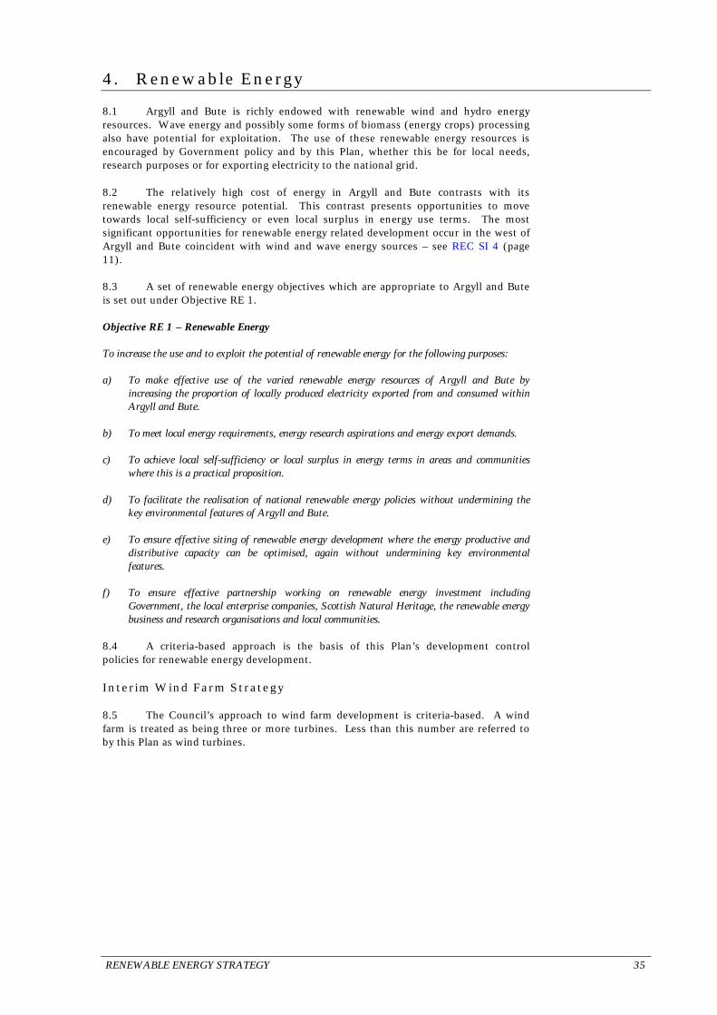
RENEWABLE ENERGY STRATEGY 35
4. Renewable Energy 8.1 Argyll and Bute is richly endowed with renewable wind and hydro energy resources. Wave energy and possibly some forms of biomass (energy crops) processing also have potential for exploitation. The use of these renewable energy resources is encouraged by Government policy and by this Plan, whether this be for local needs, research purposes or for exporting electricity to the national grid. 8.2 The relatively high cost of energy in Argyll and Bute contrasts with its renewable energy resource potential. This contrast presents opportunities to move towards local self-sufficiency or even local surplus in energy use terms. The most significant opportunities for renewable energy related development occur in the west of Argyll and Bute coincident with wind and wave energy sources – see REC SI 4 (page 11). 8.3 A set of renewable energy objectives which are appropriate to Argyll and Bute is set out under Objective RE 1. Objective RE 1 – Renewable Energy To increase the use and to exploit the potential of renewable energy for the following purposes: a) To make effective use of the varied renewable energy resources of Argyll and Bute by
increasing the proportion of locally produced electricity exported from and consumed within Argyll and Bute.
b) To meet local energy requirements, energy research aspirations and energy export demands. c) To achieve local self-sufficiency or local surplus in energy terms in areas and communities
where this is a practical proposition. d) To facilitate the realisation of national renewable energy policies without undermining the
key environmental features of Argyll and Bute. e) To ensure effective siting of renewable energy development where the energy productive and
distributive capacity can be optimised, again without undermining key environmental features.
f) To ensure effective partnership working on renewable energy investment including
Government, the local enterprise companies, Scottish Natural Heritage, the renewable energy business and research organisations and local communities.
8.4 A criteria-based approach is the basis of this Plan’s development control policies for renewable energy development. Interim Wind Farm Strategy 8.5 The Council’s approach to wind farm development is criteria-based. A wind farm is treated as being three or more turbines. Less than this number are referred to by this Plan as wind turbines.

36 RENEWABLE ENERGY STRATEGY
STRAT RE 1 – WIND FARM/WIND TURBINE DEVELOPMENT A) Wind farm development is encouraged where it is consistent with STRAT DC 7, 8 and 9. Proposals shall be supported where it can be demonstrated there is no significant adverse effect on;
• local communities • natural environment • landscape character and visual amenity • historic environment • telecommunications, transmitting or receiving systems, and
B) The Council will identify, with appropriate justification in the Local Plan, broad areas of search or, where appropriate, specific sites where wind energy development may be permitted. The Council will also indicate sensitive areas or sites which it is judged that for overriding environmental reasons, proposals for wind farm development would only be considered in exceptional circumstances in line with the criteria set out above. Issues associated with the cumulative impact of wind farm and wind turbine developments will be addressed. This will be done in partnership with the industry and other interested parties including local communities. Other Forms of Renewable Energy 8.6 There is potential to exploit other forms of renewable energy, particularly in the west of Argyll and Bute. Wave energy production has already been the subject of research and investment at Portnahaven on Islay. Local hydro schemes have also been long established eg. at Ormsary -Mid Argyll and Tobermory. Clearly, there should be broad support for a national renewable energy policy, but environmental and distributive capacity limits in Argyll and Bute place significant constraints on major investment. On the other hand, smaller scale schemes designed to serve local interests and needs may have a more practical future. STRAT RE 2 establishes a development control regime for such development. STRAT RE 2 – OTHER FORMS OF (NON-WIND ENERGY) RENEWABLE ENERGY RELATED DEVELOPMENT A) Renewable energy related development is encouraged, particularly wave, tide, hydro and biomass projects where this will help to sustain local businesses and local economies.
B) The principle of renewable energy development will be supported other than in exceptional cases where or when:
1. the development is located within a statutorily protected nature conservation site.
2. the development is located within a minor settlement.
3. the development comprises renewable energy arising from landfill, composting or incineration within or immediately adjacent the settlement boundaries.
C) Renewable energy related development shall be assessed with regard to its impact on:
1. the key features of the landscape 2. nature conservation interests 3. public safety and residential amenity 4. access considerations 5. the distributive capacity of the electricity network

UTILITIES, TELECOMMUNICATIONS AND WASTE MANAGEMENT STRATEGY 37
5. Utilities, Telecommunications and Waste Management 9.1 Land use policies relating to these topics will include detailed criteria which are best resolved at the Local Plan level. The main issues which should be addressed by these policies are set out in PROP UTW 1-3. Utilities 9.2 For the purposes of this Plan, utility-related development includes development, plant, operations and use of land for sewers and sewage treatment and disposal; or for the supply, distribution, storage and treatment of water; or for the generation, distribution, storage and supply of electricity or gas for power purposes (excluding renewable energy production). PROP UTW 1 – UTILITY-RELATED DEVELOPMENT The Argyll and Bute Local Plan shall include policies relating to:
A) The provision of sustainable urban drainage systems.
B) Circumstances when development may be resisted on the grounds that it will impose unreasonable and significant burdens on public utility systems and investment.
C) Circumstances when development will be expected to connect to available public utility systems. Telecommunications 9.3 For the purpose of the Plan, telecommunication systems are those defined in the Telecommunication Act 1984. PROP UTW 2 – TELECOMMUNICATIONS DEVELOPMENT The Argyll and Bute Local Plan shall include policies specifying where and when the principle of telecommunication development will be supported. Waste Management 9.4 For the purposes of this Plan, waste management relates to all forms of waste storage, collection, treatment or use of waste material, recycling facilities and disposal, including landfill, composting, incineration and other operations. PROP UTW 3 – WASTE MANAGEMENT The Argyll and Bute Local Plan shall include policies which:
1. require development to conform to the National Waste Strategy: Scotland and the Area Waste Plan for Argyll and Bute.
2. encourage waste minimisation, reuse and appropriate recycling within developments as well as at other stages in the waste management process.

38 MINERAL EXTRACTION STRATEGY
6. Mineral Extraction
The Ten Year Mineral landbank for Argyll and Bute 10.1 The ten year mineral landbank has been calculated with reference to three groups of mineral type: hardrock; sand and gravel; and peat for the distillery industry. Where there is a projected shortfall, ‘areas of search’ within Argyll and Bute as well as external sources are identified. The ‘areas of search’ are shown in Diagram 4 (opposite) and the current projected mineral landbank is presented in Schedule 6. SCHEDULE 6 - CURRENT PROJECTED TEN YEAR MINERAL LANDBANK FOR ARGYLL AND BUTE
MINERAL TYPE
TOTAL PRODUCTION
(TONNES)
REMAINING RESERVES
WITH EXTANT
PLANNING PERMISSION
(effective landbank in
tonnes)
WORKABLE RESERVES IF
PLANNING PERMISSION APPROVED (potential
landbank in tonnes)
EFFECTIVE LANDBANK
(YEARS)
SURPLUS/ SHORTFALL (±±±± YEARS)
AREAS OF
SEARCH
EXTERNAL SOURCES
WHICH CONTRIBUTES TO EFFECTIVE
LANDBANK
Hardrock
199,867
29,401,411
49,980,000
147.0
+135.0
No
Sources from Lochaber, Stirling and the Clyde Valley
Sand and Gravel
442,201
1,141,000
4,050,000
2.5
-7.5
Yes (see Diagram 4)
Sources from Lochaber, Stirling and the Clyde Valley
Peat
500
9000
-
18.0
10.2 The development control policies relating to mineral extraction requires a level of detailed consideration which should be addressed by the Local Plan. PROP MIN 1 sets out the main issues to be addressed by these policies. Proposal: PROP MIN 1 – DEVELOPMENT CONTROL AND MINERAL EXTRACTION The Argyll and Bute Local Plan shall include mineral extraction policies which:
A) Establish the limited circumstances when new or extended mineral extraction will be supported in Argyll and Bute having regard to the location and scale of the proposal along with:
1. the demand and supply circumstances of the planning area containing the site and the availability of alternative supply.
2. exceptional local need circumstances or export potential.
3. the need to reduce travel distance to markets.
4. the need to minimise environmental impact of extraction proposals.
5. settlement and infrastructure implications.
B) Ensure effective restoration and after use measures.

CURRENT PROJECTED 10YRMINERAL RESERVES
& ‘AREAS OF SEARCH’ FOR ARGYLL & BUTE
LochgilpheadLochgilpheadLochgilphead
RothesayRothesayRothesay
BowmoreBowmoreBowmore
CampbeltownCampbeltownCampbeltown
ObanObanOban
TobermoryTobermoryTobermory
DunoonDunoonDunoon
BUTE
TIREE
COLL
COLONSAY
ISLAY
CURRENT PROJECTED 10YRMINERAL RESERVES
& ‘AREAS OF SEARCH’ FOR ARGYLL & BUTE
MULL
JURA
Tarbert
LISMORELISMORELISMORE
DIAGRAM 4
HelensburghHelensburghHelensburgh
InverarayInverarayInverarayInverarayInverarayInverarayInveraray
39
Administration Areas Boundary Strategic Settlements
Sand & Gravel ‘Areas of Search’Areas which may offer potential for exploitation of sandand gravel resources but which require further investigationand consideration of environmental impact
Principal sand & gravel known reserves including sites withextant planning permissions
Principal hard rock known reserves including sites withextant planning permissions
Principal peat extraction known reserves including sites withextant planning permissions to serve the whisky distilleryindustry
External reserves to make up for Argyll & Bute shortfalls and to reduce traveldistance within Argyll & Bute
Key
Note: 1. This diagram identifies only these Areas of Search and principal reserves and does not cover more local resources which may be available in the community areas eg. on the islands2. The ‘Area of Search’ identified within the proposed Loch Lomond and the Trossachs National Park does not denote a specific site3. Any single ‘Area of Search’ does not imply that reserves will necessarilly be exploited
MINERAL EXTRACTION STRATEGY
GIGHA
KERRERA
SEIL
LUING
SCARBA
IONA
ARRAN
ULVA
ORONSAY
SHUNASHUNASHUNA

40 TRANSPORT AND ACCESS STRATEGY
7. Transport and Access Investment in Transport and Access 11.1 Transport and access are of critical importance to the way of life, to health, to the economy and to the future of Argyll and Bute. The nature of transport means that there are implications for strategy extending well beyond the Argyll and Bute boundaries. Transport is also a matter of particular Government concern. The National Planning Policy Guideline 17 on Transport and Planning is mainly urban-based but also recognises the need for a rural transport policy dimension. In the case of Argyll and Bute, transport policy should be tuned to the interchange potential and needs and opportunities of its Clyde Estuary, peninsular and island communities and will be taken forward by the Argyll and Bute Council’s Local Transport Strategy and West of Scotland Transport Partnership. 11.2 The priority transport and access-related proposals and recommendations in this Plan are set out in PROP SI 1-4 and in REC SI 1 and 2 (pages 6-9) in the Strategic Issues and Investment Strategy chapter. Other potential opportunities and initiatives are set out in Schedules 1-4 (pages 7-11) and many of these have a transport and access basis. At a more local level, access initiatives responding to community and partnership aspirations will continue to be pursued under the umbrella of the Argyll and Bute – Countryside Access Strategy through the Core Path Network Project. Development Control and Transport and Access 11.3 The main development control issues relating to transport and access in Argyll and Bute are of a detailed nature which will require to be addressed in the Local Plan. PROP TRANS 1 sets out broad parameters for these policy considerations. PROP TRANS 1 – DEVELOPMENT CONTROL, TRANSPORT AND ACCESS The Argyll and Bute Local Plan shall make policy provision for:
A) Facilitating public transport service to and between places of residence, work, shopping, leisure and social service and, where appropriate, selecting sites and adapting development layouts to this end.
B) Facilitating non-car borne journeys by introducing, where appropriate, effective and safe footpath and cycleway networks including provision of cycle-parking at places of employment.
C) Ensuring that other special mobility requirements are addressed including disability access and access by horse-riders.
D) Facilitating the continuity of public access and safeguarding:
• public rights of way and public access in the countryside and to and along the foreshore
• public access into development areas where this is consistent with the needs for public service vehicles to access sites and consistent with the reasonable need for privacy, security and operational integrity within private properties.
E) Requiring accesses or relevant sections of accesses serving new development to be “roads” open to the public and to be of appropriate standard for road construction consent and adoption unless: private way conditions and standards are more appropriate, having regard to the nature and scale and of the development and its settlement or countryside location.
F) Maximum car parking standards will be prescribed in the Argyll and Bute Local Plan. Where appropriate national maximum car parking standards will be applied.

TOURISM STRATEGY 41
8. Tourism 12.1 Tourism is a strategic sector which will continue to play a significant role in the economy of Argyll and Bute. It deserves special attention in terms of planning policy and partnerships; this involves continuing to work closely with the local enterprise companies and ‘Visit Scotland’. A range of objectives for tourism is set out under Objective TOUR 1: Objective TOUR 1 – Tourism To promote the growth of tourism in terms of both the quantity and quality of tourism products, and as a continuing strategic sector in the Argyll and Bute economy whilst realising: a) improved functioning of the towns of Argyll and Bute as tourist destinations and
opportunities for tourist related development within other settlements and at appropriate countryside and coastal locations; this should be commensurate with the capacity of these locations to successfully absorb development and for Argyll and Bute, as a whole, to grow as a sustainable tourist destination.
b) increased awareness of the wide variety of tourism products within Argyll and Bute including
knowledge of national tourist routes, tourist trails, tourist accommodation and of boating and yachting, recreational, cultural, business, environmental and educational-based tourism products.
c) opportunities to increase tourist activity within Argyll and Bute as a whole arising from: the
Loch Lomond and the Trossachs National Park; the potential of the west of Argyll and Bute to be promoted as an ‘Argyll Isles – Rural Development Area’; the Tourism Development Areas and water related tourism opportunities, particularly boating and yachting.
d) opportunities for ‘green tourism’ and for eco-friendly tourist initiatives which can build on:
• the Argyll and Bute biodiversity richness which is an as yet unrealised asset along with the spectacular and internationally acclaimed landward and maritime wildlife and the potential of wildlife/leisure activity to reinforce and expand the tourist season.
• the unique Argyll and Bute island -, peninsular – and mainland – landscapes,
coastscapes and seascapes.
e) an increase in quantity and quality of tourism-based local employment opportunities. f) successful management of visitor pressure in sensitive locations. 12.2 Diagram 5 (over) includes general areas where there are water-related tourist development opportunities which can be revealed by focused study within more broadly based Tourism Development Areas. There is also latent potential throughout the whole of Argyll and Bute, particularly in the west coast, for consolidation and expansion of water related tourist activity. There are, however, environmental issues which require to be balanced with this expansion potential. REC TOUR 1 recommends that this potential and balance be the subject of partnership study. REC TOUR 1 – WATER RELATED TOURISM OPPORTUNITIES It is recommended that Argyll and Bute Council, Scottish Natural Heritage, Sport Scotland, Visit Scotland, the local enterprise companies and interested partners, engage in a focused study to explore the potential for expanding water related tourist activity and development balanced with environmental safeguards and enhancement in Argyll and Bute. 12.3 Detailed policies which can guide development control responses to tourism related development will be presented in the Argyll and Bute Local Plan. These should sit within the framework of the Development Control Strategy in this Plan.

TOURISM INFRASTRUCTURE
LochgilpheadLochgilpheadLochgilphead
RothesayRothesayRothesay
BowmoreBowmoreBowmore
TobermoryTobermoryTobermory
DunoonDunoonDunoon
TIREE
COLL
COLONSAY
ISLAY
TOURISM INFRASTRUCTURE
MULL
JURA
Tarbert
LISMORELISMORELISMORE
DIAGRAM 5
InverarayInverarayInverarayInverarayInverarayInverarayInveraray
BUTE
CampbeltownCampbeltownCampbeltown
HelensburghHelensburghHelensburgh
LochgilpheadLochgilpheadLochgilphead
42 TOURISM STRATEGY
GIGHA
IONA
KERRERAKERRERA
SEILSEIL
LUINGLUING
SCARBASCARBA
KERRERA
SEIL
LUING
SCARBA
ARRAN
ULVA
ORONSAY
SHUNASHUNASHUNA
AI-RDA
AI-RDA
AI-RDA
AI-RDA
AI-RDA
AI-RDA
Administratiive Areas Boundary
Strategic Settlements
National Tourist Route
Clyde Sea Lochs Trail
West Highland Way
Oban-Fort William Proposed Cycle Route
Ferry Ports/Routes
Loch Lomond and the Trossachs National Park
Potential Argyll Isles - Rural Development Area
Main Tourist Information Centres
Main Tourist Attractions
Tourism Development Areas
Water Related Tourist Development Opportunities/Proposed Feasibility Study
Key
AI-RDA
Uist and Barra Ferry Service
LLTT-NPLLTT-NPLLTT-NP
ObanObanOban

HOUSING STRATEGY 43
9. Housing 13.1 The basis for the housing provision is prescribed under PROP SET 4. Adjustment to the housing provision is likely to be required in response to updated population and household projections, particularly when the results of the 2001 census become known. Census results are to be published in early 2003. 13.2 STRAT HO 1 sets out development control policies for housing; these should be expanded on and refined by the Local Plan. The policies are designed to: • support the delivery of local needs and affordable housing. • support agriculture, crofting and rural industries and diversification schemes. • support opportunistic housing developments, of appropriate form and scale, to take
place on suitable settlement and countryside sites. • support high quality development layout and design and special group needs
provision. STRAT HO 1 – HOUSING – DEVELOPMENT CONTROL POLICY A) Planning conditions and planning agreements shall be required, in appropriate cases, to facilitate the delivery of housing to meet local housing need, including affordable housing provision.
B) Housing development, of appropriate forms and scale is encouraged in the countryside where it will support farm and estate diversification and the viability of crofts and other rural industries, such as associated with forestry and woodland management.
C) Outwith formally allocated housing sites, appropriate forms and scales of housing infill, rounding-off, redevelopment and change of use to housing is encouraged within the settlements and in the countryside where it is consistent with STRAT DC 1-10.
D) Encouragement shall be given to innovative and sympathetic housing development layout and designs which are appropriate to their mainland, island, town, village, minor settlement, countryside and coastal settings. Overly suburbanised forms of development are unlikely to be accepted in sensitive villages, minor settlements and countryside locations.
E) Housing development shall incorporate appropriate recreational/play space/open space provision and shall take account of special group access needs, crime prevention and expert advice from bodies such as SportsScotland and Strathclyde Police.

44 IMPLEMENTATION STRATEGY
Implementation 14.1 The measure of success of this Structure Plan will be how far the Plan has succeeded in realising its Overall Aims (page 1). This will involve assessing what value has been added and what enhancement made to the economic, social and environmental assets of Argyll and Bute. However, investment resources are scarce and it is unrealistic to pursue every opportunity at the same time. A framework for considering priorities over the short- and long-term is needed. The Strategic Issues and Investment Strategy along with the topic strategies provide such a framework for considering these priorities and are the focus of PROP IMP 1: PROP IMP 1 – MONITORING OF PROGRESS ON THE STRATEGIC ISSUES, INVESTMENT STRATEGY AND TOPIC STRATEGIES A) Priority should be given to achieving sustainable development under STRAT SI 1 and to Strategic Issues 1-7 and the implementation of the proposals and recommendations PROP SI 1-4 and REC SI 1-4. When feasible, progress will also be pursued on the investment opportunities and initiatives set out in Schedules 1-4 and on the topic strategies.
B) By agreement and within resource availability, support by partners (including the local enterprise companies and local economic forums) shall be sought in the implementation of these proposals and recommendations.
C) Outcomes shall be monitored and reviewed on an annual basis with formal reviews incorporated into the 3-5 year Local Plan and 5-10 year Structure Plan review programmes. 14.2 The achievement of sustainable development is one of the Overall Aims of this Plan. Monitoring sustainable development indicators and outcomes relating to these indicators can reveal how successful the Development Plan, development control and partnership processes have been in this regard. PROP IMP 2 (opposite) establishes a broad range of outcomes and indicators which shall be monitored and audits which shall be undertaken.
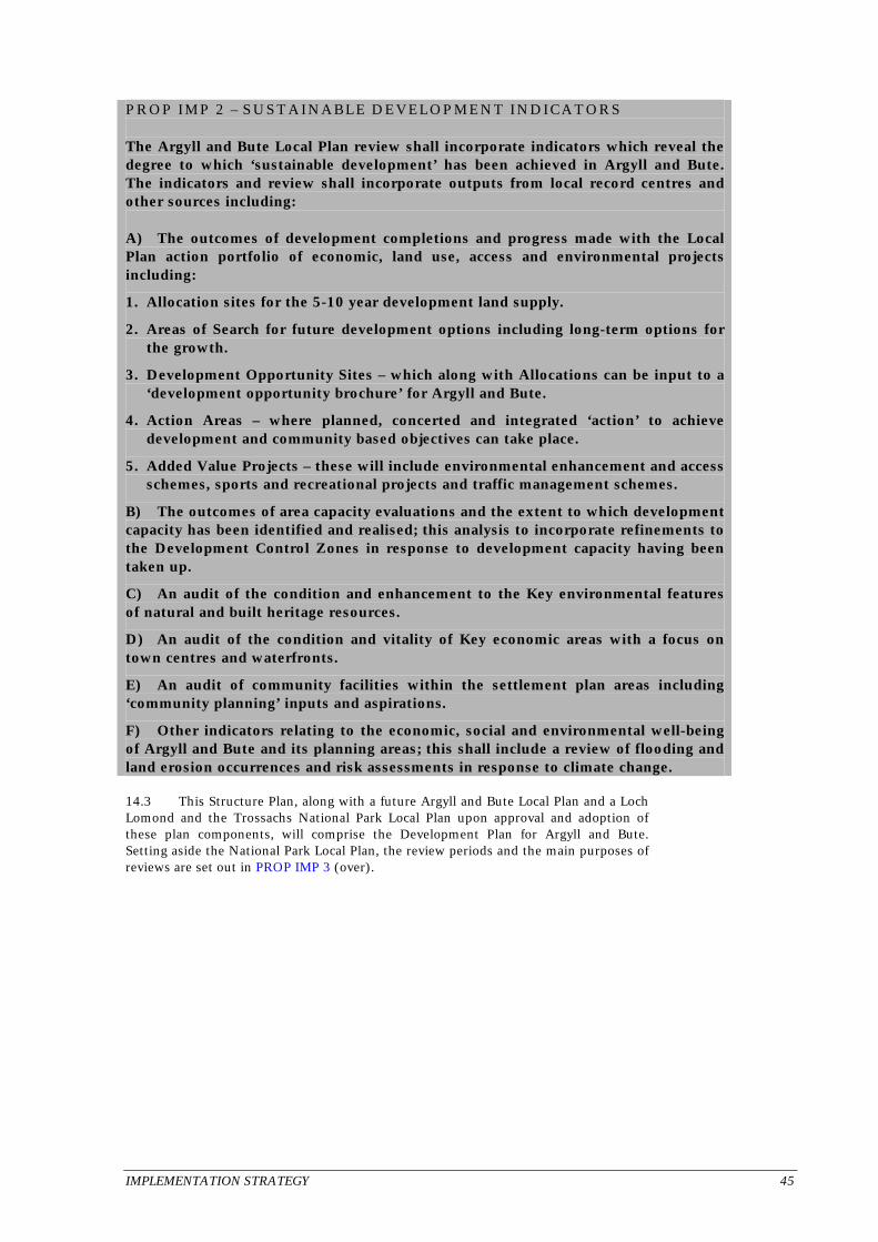
IMPLEMENTATION STRATEGY 45
PROP IMP 2 – SUSTAINABLE DEVELOPMENT INDICATORS The Argyll and Bute Local Plan review shall incorporate indicators which reveal the degree to which ‘sustainable development’ has been achieved in Argyll and Bute. The indicators and review shall incorporate outputs from local record centres and other sources including: A) The outcomes of development completions and progress made with the Local Plan action portfolio of economic, land use, access and environmental projects including:
1. Allocation sites for the 5-10 year development land supply.
2. Areas of Search for future development options including long-term options for the growth.
3. Development Opportunity Sites – which along with Allocations can be input to a ‘development opportunity brochure’ for Argyll and Bute.
4. Action Areas – where planned, concerted and integrated ‘action’ to achieve development and community based objectives can take place.
5. Added Value Projects – these will include environmental enhancement and access schemes, sports and recreational projects and traffic management schemes.
B) The outcomes of area capacity evaluations and the extent to which development capacity has been identified and realised; this analysis to incorporate refinements to the Development Control Zones in response to development capacity having been taken up.
C) An audit of the condition and enhancement to the Key environmental features of natural and built heritage resources.
D) An audit of the condition and vitality of Key economic areas with a focus on town centres and waterfronts.
E) An audit of community facilities within the settlement plan areas including ‘community planning’ inputs and aspirations.
F) Other indicators relating to the economic, social and environmental well-being of Argyll and Bute and its planning areas; this shall include a review of flooding and land erosion occurrences and risk assessments in response to climate change. 14.3 This Structure Plan, along with a future Argyll and Bute Local Plan and a Loch Lomond and the Trossachs National Park Local Plan upon approval and adoption of these plan components, will comprise the Development Plan for Argyll and Bute. Setting aside the National Park Local Plan, the review periods and the main purposes of reviews are set out in PROP IMP 3 (over).

46 IMPLEMENTATION STRATEGY
PROP IMP 3 – DEVELOPMENT PLAN PREPARATION AND REVIEW A) Review of this Structure Plan shall commence every five years. The Structure Plan shall be updated by way of modification or replacement (if necessary) at least once every 10 years (the Structure Plan ‘plan period’). This update shall reset the strategic objectives and longer-term vision of the Plan in consultation with local communities, developers and agencies.
B) The Argyll and Bute Local Plan shall be reviewed, modified or replaced in consultation with local communities, developers and agencies. Reviews shall commence at least every three years. The Local Plan shall be updated by way of selective area or settlement plan review or subject based modifications or replacement (if necessary) at least once every five years; this review shall have the effect of rolling forward the 5 and 10 year development land provision and the Local Plan itself.
C) Subject Plans may be proposed by the Argyll and Bute Local Plan or else be initiated between Local Plan reviews as new issues arise and then incorporated in the Local Plan review process.
D) As part of the Structure Plan and the Local Plan reviews, the number of departures to this Structure Plan and Local Plan shall be monitored. This shall include a review of the reasons for these departures including an assessment of whether this points to a flaw or omission in development control policy which therefore requires remedying.
E) The Structure Plan and Local Plan review shall address material considerations not included in the present Plan and which have influenced planning determinations. As appropriate, these material considerations (including updated National Planning Guidance) shall be incorporated into the modified or replaced Structure Plan or Local Plan. 14.4 Sufficient development land is available or is expected to be made available to deliver the business and industry and housing provision elements of this Plan. This overall development provision can be effectively serviced by existing or programmed infrastructure provision. The remaining elements of the Plan will require commitment and, to varying degrees, partnership working to draw down and marshall resources for implementation. The effectiveness of this resourcing will be monitored and reviewed.

Argyll and Bute CouncilDevelopment and Environment Services
Statutory PlansKilmory CastleLochgilphead
ArgyllScotlandPA31 8RT