addendum - washington county, minnesota
TRANSCRIPT

Addendum
to the
MANUAL OF GUIDELINES FOR PLATTING IN MINNESOTA

Inside cover

Introduction
The Washington County Addendum to the Manual of Guidelines for Platting in Minnesota
is a publication of the Washington County Surveyor (Survey Division of Washington County
Public Works). Hereinafter referred to as the Addendum, it provides guidance specific to
platting in Washington County.
Please use the Addendum to identify areas where local requirements and/or county policies
supplement (or differ from) the requirements set forth in the Manual of Guidelines for Platting in
Minnesota [MSPS/MACS, 2009] hereinafter referred to as the Manual.
The Addendum (used with the Manual) supports compliance with Minnesota Statutes,
professional standards, local requirements, and Washington County policies.
Part 1 of the Addendum covers plat submittal requirements and review fees for Washington
County. Parts 2 and 3 follow particular sections or subsections on documentation and graphics
in the Manual. Page numbers from the Manual are cross referenced in each applicable section of
the Addendum. Part 4 covers the steps to record the plat and are specific to Washington County.
Always give careful consideration to any statute, ordinance, administrative rule, or policy that
may be in conflict with the recommendations and guidelines contained in the Washington
County Addendum.
Direct any questions or comments regarding this Addendum, and/or subdivision plats, to:
Survey Division
Washington County Public Works
11660 Myeron Road North
Stillwater, Minnesota 55082
Phone: (651) 430-4300
www.co.washington.mn.us/surveyor
J:\DEPT_ADM\Office\Manuals\Plat Manual\Addendum.pdf
September 2011
Latest revision: May 2018

Table of Contents
Part 1 Document Submittal ............................................................................................................ 1
1. Preliminary Plan........................................................................................................ 2
2. Proposed Plat ............................................................................................................ 2
Part 2 Documentation .................................................................................................................... 5
1. Plats ........................................................................................................................... 6
2. Registered Land Surveys ........................................................................................ 12
Part 3 Graphics ............................................................................................................................. 13
1. Orientation of Bearings and Plats ........................................................................... 14
2. Monumentation ....................................................................................................... 14
3. Lettering Size .......................................................................................................... 15
4. Block and Lot Numbers .......................................................................................... 15
5. Parks ........................................................................................................................ 15
6. Outlots ..................................................................................................................... 15
7. Public Ways ............................................................................................................ 15
8. Curve Data .............................................................................................................. 16
9. Water Boundaries.................................................................................................... 16
10. Easements .................................................................................................................. 18
11. Adjoining Property..................................................................................................... 19
12. Replats........................................................................................................................ 19
13. Vicinity Map or Location Map .................................................................................. 19
14. Minnesota Coordinate System ................................................................................... 19
15. Arrowed Designation Lines ....................................................................................... 20
Part 4 Recording the Plat ............................................................................................................. 21
1. Final Review ........................................................................................................... 22
2. Material, Quantity and Specifications..................................................................... 22
3. Procedure for Recording ......................................................................................... 22
Appendix ....................................................................................................................................... 25
Washington County Plat Review Checklist ...................................................................... 26
Chapter 820, Laws of Minnesota, 1971 ............................................................................ 28
Filing Surveys in Washington County .............................................................................. 29

Minnesota Statutes § 505.03 Subd. 2 Flow Chart ............................................................. 31
Plat Review by Transportation Department(s) ................................................................. 32
Watershed District Map .................................................................................................... 33
Minor Subdivision Plat ..................................................................................................... 34
Local Planning Commission Review and Approval ......................................................... 35
Uniform Street Naming and Property Numbering System ............................................... 36
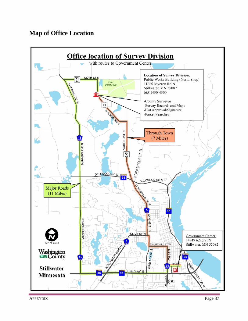
Map of Office Location .................................................................................................... 37

This page intentionally left blank

Page 1
PART 1
DOCUMENT SUBMITTAL
PART 1: DOCUMENT SUBMITTAL Page 2
1. Preliminary Plan
A. Cities and Townships
Prepare the preliminary plans according to the local government unit’s
subdivision ordinance.
All approvals required by the city/township must be fulfilled prior to submitting
the proposed plat to the County Surveyor. Approvals may include:
o Planning Commission
o City Council/Town Board
o State and/or County Highway Engineer (See page 32, Appendix)
o Watershed District approval/permit (See map on page 33, Appendix)
2. Proposed Plat
A. County Surveyor’s Review
After the preliminary plan is approved by the city/township, the proposed plat may be
submitted to the County Surveyor to begin the review process. Review items will
include the following:
Mathematical closure
Compliance with applicable Minnesota Statutes
Compliance with the Manual of Guidelines for Platting in Minnesota
Compliance with Washington County specific rules/regulations and items
outlined in this Addendum
Please check your plat for errors and omissions before you submit your plat to
the County Surveyor. Plats received with an excessive number of errors and
omissions may result in the plat being returned without a complete review performed.
PART 1: DOCUMENT SUBMITTAL Page 3
B. Plat Review Fees
Subdivision Plats and Registered Land Surveys:
The base fee is $350.00.
o Add $35.00 for each lot, outlot, park, or tract.
o The minimum fee is $525.00. (any plat with 1 to 5 lots, tracts, etc.)
The review will not begin until the correct fee has been paid.
Plats are reviewed in the order received.
If more than 3 reviews are necessary, a $400.00 fee will be charged for the fourth
review and each additional review thereafter.
Revision fees:
A $150.00 fee will be charged when revisions are made that affect plat lines after
the initial review is in progress.
Plus $35.00 per revised or additional lot, outlot, tract or park.
If substantial revisions are made after the initial review is in progress, an entirely
new plat review fee may be charged.
o Such revisions include, but are not limited to: revised plat description;
revised exterior boundary; revised street, block, lot, or tract layout.
o What constitutes substantial revisions will be determined by the County
Surveyor’s Office.

PART 1: DOCUMENT SUBMITTAL Page 4
C. Plat Submittal Requirements
Calculate the review fee for any subdivision plat or Registered Land Survey using
the fee schedule found above.
Make check payable to: Washington County
Submit two (2) copies of the proposed plat/RLS/minor subdivision.
Submit a current copy of one (1) of the following:
o Opinion of Title – prepared by an attorney
o Title Insurance Policy
o Commitment to Insure
Mail or deliver proposed plat and fee to:
Survey Division
Washington County Public Works
11660 Myeron Road North
Stillwater, MN 55082
See page 37 in the Appendix for route locations.
D. Notes:
Title opinions, insurance policies, and commitments must be current within 30
days of recording the plat.
All plats are reviewed in the order received and paid.
No review will begin until the correct fee amount has been received.
For any plat abutting state and/or county right-of-way, please refer to Plat Review
by Transportation Department(s) on page 32 in the Appendix.
Any proposed plat which has been inactive in the County Surveyor’s Office for
more than 120 days may be subject to further review and additional fees upon
resuming activity.

Page 5
PART 2
DOCUMENTATION

PART 2: DOCUMENTATION Page 6
1. Plats (Supplemental to page 4 of the MSPS/MACS Manual)
A. Plat Name
Make the plat name using capital letters from the English alphabet.
Do not use punctuation marks or underline the plat name.
A proposed plat name will be compared with plats of record in the office of the
County Recorder/Registrar of Titles. The name of (unrecorded) proposed plats
will be reserved and protected from duplication for a period of one (1) year.
When one year has elapsed with no further activity on the proposed plat, the
Surveyor’s Office may discard the file and the plat name reservation will expire.
B. Miscellaneous Notes:
The County Recorder/Registrar of Titles will not record a plat that creates a parcel
which is partially Torrens and partially abstract property. To comply with this
requirement, lot lines on the proposed plat must coincide with existing boundaries
of the registered property.
When writing new land descriptions, the recommended guidebook is
Fant, Freeman & Madson on Writing Land Descriptions [MSPS 2011].
Previous editions are known as Report Four.
Partnerships apparently have no limitation to form. Therefore, each partnership
will be regarded individually until such forms are standardized. Partnerships must
identify in which state it is organized and the type of partnership (e.g., limited,
etc.).
If the owner is listed on the deed (or contract, or mortgage) individually, and the
individual is married, the spouse must be included in the instrument of dedication.
Example:
Olaus S. Olson and Engeborg B. Olson, husband and wife, fee owners of . . .
A plat executed under the statute must be joined in by any mortgagee (the bank or
lender) as well as the fee owner. [Op. Atty. Gen. 311, June 16, 1925]
Furthermore, when a mortgagee is included on the plat, the plat must then be
signed by an authorized representative.
[Section 505.021, Subd. 3, Minnesota Statutes]
PART 2: DOCUMENTATION Page 7
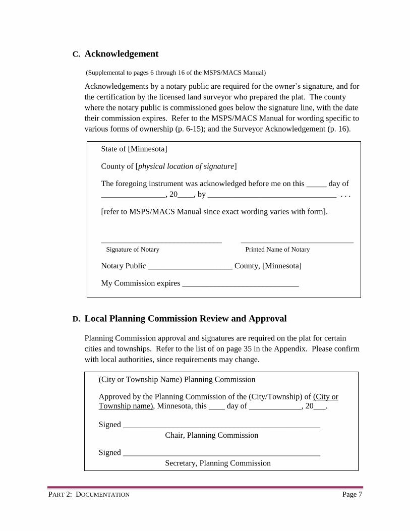
C. Acknowledgement
(Supplemental to pages 6 through 16 of the MSPS/MACS Manual)
Acknowledgements by a notary public are required for the owner’s signature, and for
the certification by the licensed land surveyor who prepared the plat. The county
where the notary public is commissioned goes below the signature line, with the date
their commission expires. Refer to the MSPS/MACS Manual for wording specific to
various forms of ownership (p. 6-15); and the Surveyor Acknowledgement (p. 16).
D. Local Planning Commission Review and Approval
Planning Commission approval and signatures are required on the plat for certain
cities and townships. Refer to the list of on page 35 in the Appendix. Please confirm
with local authorities, since requirements may change.
State of [Minnesota]
County of [physical location of signature]
The foregoing instrument was acknowledged before me on this _____ day of
________________, 20____, by ________________________________ . . .
[refer to MSPS/MACS Manual since exact wording varies with form].
______________________________ ____________________________
Signature of Notary Printed Name of Notary
Notary Public _____________________ County, [Minnesota]
My Commission expires _____________________________
(City or Township Name) Planning Commission
Approved by the Planning Commission of the (City/Township) of (City or
Township name), Minnesota, this ____ day of _____________, 20___.
Signed _________________________________________________
Chair, Planning Commission
Signed _________________________________________________
Secretary, Planning Commission

PART 2: DOCUMENTATION Page 8
E. Governing Body Approval Certificates
Plats that subdivide land are subject to the approval of the elected body of the local
government unit. [Section 505.03, Subd. 1, Minnesota Statutes]
City Council
Town Board
(City Name)
This plat was approved by the City Council of (City) , Minnesota, this ____
day of ______________, 20___, and hereby certifies compliance with all
requirements as set forth in Minnesota Statutes, Section 505.03, Subd. 2.
Signed _________________________________________________
Mayor
Signed _________________________________________________
Clerk
(Township Name)
This plat was approved by the Town Board of (Township) , Minnesota, this
____ day of ______________, 20___, and hereby certifies compliance with all
requirements as set forth in Minnesota Statutes, Section 505.03, Subd. 2.
Signed _________________________________________________
Chair
Signed _________________________________________________
Clerk

PART 2: DOCUMENTATION Page 9
F. County Board Approval
Plats within unincorporated areas of the county (townships) with a population not
exceeding 5,000 people require county board approval. [Section 505.03, Subd. 1,
Minnesota Statutes]
The county board has the power to control and regulate the platting of
subdivisions of land and the laying out of streets and other public ways without
the boundaries of municipalities. [Section 505.09, Subd. 1, Minnesota Statutes]
The county board is prohibited from approving any plat lying in a town, which
has appointed a planning and zoning commission unless the town board approves
the plat and the laying of streets and other public ways shown on it. The approval
must be endorsed on the plat and signed by the chair of the town board.
[Section 505.09, Subd. 1a., Minnesota Statutes]
Washington County Board
I hereby certify that on the ____ day of _____________, 20___, the Board of
Commissioners of Washington County, approved this plat.
Signed _________________________________________________
Chair, County Board

PART 2: DOCUMENTATION Page 10
G. County Surveyor Approval
All plats prepared for recording are subject to approval by the Washington County
Surveyor pursuant to Chapter 820, Laws of Minnesota, 1971.
(See page 28, Appendix)
H. County Auditor/Treasurer Approval
County Surveyor
Pursuant to Chapter 820, Laws of Minnesota, 1971, and in accordance with
Minnesota Statutes, Section 505.021, Subd. 11, this plat has been reviewed and
approved this ____ day of _______________, 20 ____.
By__________________________ By__________________________
Washington County Surveyor
County Auditor/Treasurer
Pursuant to Minnesota Statutes, Section 505.021, Subd.9 and Section 272.12,
taxes payable in the year 20___, on real estate hereinbefore described, have
been paid; and there are no delinquent taxes, and transfer has been entered on
this ________, day of ___________________, 20____.
By______________________________ By ________________________
Washington County Auditor / Treasurer Deputy

PART 2: DOCUMENTATION Page 11
I. Recording Certificates
Abstract property
Torrens Property
County Recorder
Document Number __________________
I hereby certify that this instrument was recorded in the Office of the County
Recorder for record on this _____ day of ______________, 20 ____ at ____
o'clock ____.M. and was duly recorded in Washington County Records.
By______________________________ By ________________________
Washington County Recorder Deputy
County Registrar of Titles
Document Number __________________
I hereby certify that this instrument was filed in the Office of the Registrar of
Titles for record on this _____ day of ______________, 20 ____ at ____
o'clock ____.M. and was duly recorded in Washington County Records.
By______________________________ By ________________________
Washington County Registrar of Titles Deputy
PART 2: DOCUMENTATION Page 12
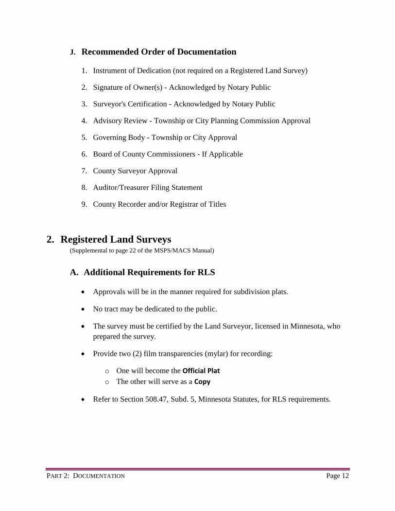
J. Recommended Order of Documentation
1. Instrument of Dedication (not required on a Registered Land Survey)
2. Signature of Owner(s) - Acknowledged by Notary Public
3. Surveyor's Certification - Acknowledged by Notary Public
4. Advisory Review - Township or City Planning Commission Approval
5. Governing Body - Township or City Approval
6. Board of County Commissioners - If Applicable
7. County Surveyor Approval
8. Auditor/Treasurer Filing Statement
9. County Recorder and/or Registrar of Titles
2. Registered Land Surveys (Supplemental to page 22 of the MSPS/MACS Manual)
A. Additional Requirements for RLS
Approvals will be in the manner required for subdivision plats.
No tract may be dedicated to the public.
The survey must be certified by the Land Surveyor, licensed in Minnesota, who
prepared the survey.
Provide two (2) film transparencies (mylar) for recording:
o One will become the Official Plat
o The other will serve as a Copy
Refer to Section 508.47, Subd. 5, Minnesota Statutes, for RLS requirements.

Page 13
PART 3
GRAPHICS
PART 3: GRAPHICS Page 14
1. Orientation of Bearings and Plats
(Supplemental to page 29 of the MSPS/MACS Manual)
A. Bearing Orientation
Orientation to the Washington County Coordinate System (NAD 83/1986) is
preferred.
If the bearing orientation of the plat is referenced to a specific line, show and label
that line on the plat.
B. Bearings or Directions
Show bearings (or azimuths) on the graphic portion of the plat in the same
direction as called for in the property description.
Show bearings (or azimuths) on all lines of the plat except where they are interior
lines and are clearly parallel with adjacent lines.
2. Monumentation
(Supplemental to page 31 of the MSPS/MACS Manual)
Terminate lot lines and/or block lines, etc. at the circumference or outer edge of
monument symbols.
Washington County requires that outlots and lands dedicated to the public be
monumented in the same manner as block boundaries.
Show ties from the plat boundary to at least 2 U.S. Public Land Survey corners by
direction and distance.
Note: Ties to section corners are not necessary on a replat where the underlying plat
has been tied to the U.S. Public Land Survey System.
A plat monument must be set at all angle and curve points on the exterior boundary
of the plat prior to recording. [Section 505.021, Subd. 10, Minnesota Statutes]
Washington County performs field checks to ensure that monuments have been
set as required by statute.
When it is not practical to set a plat monument due to water, an existing
thoroughfare, or other obstacle, a witness monument may be set as depicted on the
plat. [Section 505.021, Subd. 10, Minnesota Statutes]

PART 3: GRAPHICS Page 15
3. Lettering Size (Supplemental to page 33 of the MSPS/MACS Manual)
A document presented for recording must be sufficiently legible to reproduce a
readable copy using the county recorder’s method of reproduction.
[Minnesota Document Standards – Section 507.093, (7), Minnesota Statutes]
Recommended minimum text size is 8-point type. This is equivalent to 0.08 inches,
or 80 template size. Larger text sizes are preferred.
[Section 505.021, Subd. 5, Minnesota Statutes]
4. Block and Lot Numbers (Supplemental to page 33 of the MSPS/MACS Manual)
Consecutive lot or block numbering must not be continued from one plat to another.
5. Parks (Supplemental to page 34 of the MSPS/MACS Manual)
Dedicate parks within the Owner’s Dedication Statement.
6. Outlots (Supplemental to page 34 of the MSPS/MACS Manual)
When an Outlot line adjoins several individual lot lines, please show the overall
distance for the Outlot in addition to each lot dimension.
7. Public Ways
(Supplemental to page 35 of the MSPS/MACS Manual)
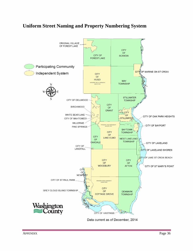
A. Uniform Street Naming and Property Numbering
Name all public ways on the plat in conformance with the local governing body.
Certain cities and townships in Washington County participate in the Uniform
Street Naming and Property Numbering System.
See page 36 in the Appendix for a map of participating communities.
Refer to the Index Map of the Street Naming and Numbering System.
The map is available by calling the Survey Division at 651-430-4300.
For questions on street names and address numbers in participating communities,
please call the Survey Division.
PART 3: GRAPHICS Page 16
B. Plat Review by Transportation Department(s)
Any proposed plat which abuts a state or county highway must be reviewed by the
appropriate road authority. See page 32 in the Appendix.
Flow Chart for road authority review appears on page 31 in the Appendix.
C. Miscellaneous note on Public Ways
Label any adjoining right-of-way plats with stippled lettering.
When there is dual designation of public ways, show the municipality’s name
first, followed by the highway name in parenthesis.
Examples:
Osgood Avenue North (Washington County Road No. 67)
Dellwood Road North (State Highway No. 96)
Existing Access Control may be shown.
When the right-of-way is of varying widths, label the centerline as described
(book and page) or as traveled (date).
8. Curve Data (Supplemental to page 37 of the MSPS/MACS Manual)
The right-of-way radius need not be shown when the R/W is concentric with the
centerline.
Label non-tangential curves as "not tangent" at the point of curvature. Show the
chord direction for non-tangential curves or for curved line segments that do not
have at least one tangent plat line segment either entering or exiting the curve.
9. Water Boundaries
(Supplemental to page 38 of the MSPS/MACS Manual)
A. Benchmark and Elevations
If the plat abuts a public body of water which does not have a known established
high water elevation as determined by the Minnesota Department of Natural
Resources (Division of Water, Soils and Minerals) or by the United States Army
Corps of Engineers, Washington County may require that a 100-year flood
elevation be established for the purpose of determining lowest finished floor

PART 3: GRAPHICS Page 17
elevations. Therefore, the following statement may be required to be shown on
said plat:
The 100-year flood elevation of (Name of Lake) has been determined to be
(elevation) . National Geodetic Vertical Datum of 1929, (NGVD29) or North
American Vertical Datum of 1988, (NAVD88).
Any building to be constructed on a lot in (Name of Plat) shall not have a
finished floor elevation lower than 2 feet above the 100-year flood elevation.
This datum shall remain in effect until such time as the State Department of
Natural Resources Division of Water, Soils and Minerals, (or the U.S. Army
Corps of Engineers) establishes the 100-year flood elevation at a greater or lesser
elevation.
B. Wet Land
The surveyor preparing the plat is responsible for correctly locating, plainly
showing and designating all “wet lands”, i.e.: rivers, streams, creeks, drainage
ditches, lakes, ponds, swamps, as defined in Section 505.01, Subd. 3, (l),
Minnesota Statutes
Most municipalities are more restrictive and in addition to the statutory
requirements, also require the identification and delineation of existing
“wetlands” that are not addressed in Section 505.01, Subd. 3, (I). If required,
these wetlands should be identified and delineated by a wetlands specialist or
wetlands delineation expert. Show and label these “wetlands” on the plat with the
individual or agency responsible for their delineation. The basic difference
between “wet lands” and “wetlands” is as follows: a “wet land” is one of the types
listed in Section 505.01, Subd. 3. The qualifying test is whether water is visible
to the layperson, or individuals not specifically trained in the identification of
hydric soils or hydrophytic vegetation types. Whereas, a “wetland” is a more
encompassing label that includes those types listed in Section 505.01, Subd. 3, in
addition to all other wetlands such as those categorized by the U.S. Fish and
Wildlife Service (Circular 39, 1971). Some of these wetlands do not have visible
water and identifying them is more difficult or impossible for the layperson
without specific training in the identification of hydric soils or vegetative changes.
When showing “wetland” boundaries (types not covered by Chapter 505
definition), draft with a fine dashed line. Label “WETLAND” in all capital letters
in fine solid font within the wetland boundary.

PART 3: GRAPHICS Page 18
If a plat contains a wet land, wetland, watercourse, or public ditch which is listed,
shown, or categorized as a Minnesota DNR protected water, please label as such
on the plat and show the DNR inventory number.
10. Easements
(Supplemental to page 40 of the MSPS/MACS Manual)
A. Existing Easements
Show any public easement existing prior to the plat, and which is an encumbrance
on the property being platted.
Examples include: power line, pipeline, telephone, railroad, scenic, etc.
Tie the existing easement by distance and direction to the proposed plat boundary.
Label the existing easement with the document number, or book and page, of the
recorded document that created said easement.
Distinguish between existing easements and those created by the plat by using
dashed line types that differ.
Do not reference existing easements within the Owner’s Dedication Statement on
the proposed plat.
B. Vacated Easements
Vacate any existing or underlying easement that may be in conflict with the
proposed plat before the proposed plat is recorded.
Do not show vacated easements on the proposed plat. Exceptions can be made if
the boundary of the vacated easement is pertinent to the plat or necessary for
boundary retracement.
Proof of vacation must be provided for any street, alley, drainage and utility
easement, etc. that is vacated prior to recording the proposed plat.
A city or township resolution to vacate a street, alley, easement, etc., is not
considered proof of vacation unless the resolution has been properly recorded in
the office of the County Recorder or Registrar of Titles.
PART 3: GRAPHICS Page 19
C. Created Easements
Easements created by the plat are limited to drainage easements, public ways, and
public utility easements as defined in Section 505.01, Subd. 3 and Section
505.021, Subd. 7, Minnesota Statutes.
New easements must be dedicated to “the public” and not to any specific entity.
11. Adjoining Property
(Supplemental to page 43 of the MSPS/MACS Manual)
Show lot lines, or lot and block numbers, of adjoining plats only if they are referred
to in the description of the land being platted.
Show the name of any public road adjoining the plat in stippled letters.
Please do not label any adjoining property which has not been platted.
Show and label any adjoining railroads.
12. Replats (Supplemental to page 43 of the MSPS/MACS Manual)
If a proposed plat is a re-plat of a recently recorded plat or a portion thereof, it is not
necessary to tie the proposed plat to the U.S. Public Land Survey System, provided
that the underlying plat was tied to the U.S. Public Land Survey System.
Vacate any existing or underlying easement that may be in conflict with the proposed
plat before the proposed plat is recorded. (See 10. B. on page 18.)
13. Vicinity Map or Location Map (Supplemental to page 43 of the MSPS/MACS Manual)
Identify prominent physical features within the section, such as highways, rivers,
lakes, railroads, etc., on a vicinity or location map.
14. Minnesota Coordinate System (Not addressed in the MSPS/MACS Manual)
Coordinates based on the Minnesota Coordinate System may be shown on one or
more points for supplemental information.
See Sections 505.18 thru 505.28, Minnesota Statutes, for additional information.

PART 3: GRAPHICS Page 20
15. Arrowed Designation Lines (Not addressed in the MSPS/MACS Manual)
Use a dashed or dotted line type for arrowed lines (leader lines) that differ from other
dashed or dotted line types shown on the plat.
Page 21
PART 4
RECORDING THE PLAT

PART 4: RECORDING THE PLAT Page 22
1. Final Review
Upon review, the County Surveyor’s Office will inform the submitting surveyor, in
writing, that “the proposed plat (or Registered Land Survey) complies with current
standards, and you may proceed toward its completion.” In other words: make
mylars, get the required signatures, and prepare to record the plat.
2. Material, Quantity and Specifications
Submit plats for recording on 22 inch x 34 inch x 4 mil (.004 inch minimum
thickness) stable base, double matte finish transparent mylar film with a chemically
fixed permanent black photographic image.
Submit two (2) film transparencies (mylar) of each sheet for recording.
o One will become the Official Plat
o The other will serve as a Copy
o Washington County will add such label at top center, outside the border line.
Do not fold plats. Plats in unsatisfactory condition will not be approved for
recording.
Please use permanent, water-proof, black ink for all signatures and dates.
[Section 505.021, Subdivision 3, Minnesota Statutes]
Note: The professional surveyor preparing the plat is in the best position to assure
that permanent, water-proof, black ink is used for all signatures.
3. Procedure for Recording
Step One: Land Surveyor’s certification
The land surveyor, licensed in Minnesota, who surveyed and prepared the plat
must certify the plat with their signature. (Refer to page 16, MSPS/MACS Manual)
[Minn. Administrative Rules, 1800.4200 Certify and Signature on Plans]
[Section 505.021, Subd. 9, Minnesota Statutes]
A Notary Public must acknowledge the signature of the licensed land surveyor.
The notary must clearly print in black ink (or stamp) his or her name with their
signature, and print the commission expiration date in the space provided.
The Month of all dates must be spelled out in full.
The left margin of the plat is for book binding only.
PART 4: RECORDING THE PLAT Page 23
Step Two: Owner’s signature
All parties having an ownership interest in the plat must sign the Official Plat and
copy(s). This includes the owner’s spouse and any mortgagee.
The mortgagee may provide a Consent to Plat in lieu of their signature on the
plat. (Refer to page 9, MSPS/MACS Manual)
Corporations having seals must affix their seal in the area of the corporation
signatures.
All signatures must be exactly as written in the dedication.
A Notary Public must acknowledge the signature of the owner(s). The notary
must clearly print in black ink (or stamp) his or her name with their signature, and
print the commission expiration date in the space provided.
The Month of all dates must be spelled out in full.
On a Registered Land Survey (RLS), the owner’s signature is not a requirement.
Step Three: Local Government Unit and Planning Commission
Certification of approval by the local elected government unit or an authorized
official is required. See page 8 for City and Township approval blocks. [Section
505.021, Subd. 9, Minnesota Statutes]
Some local government units require advisory review and approval of subdivision
plats. Cities and Townships that require a Planning Commission signature on the
proposed plat are listed on page 35 in the Appendix. Use the signature block
shown on page 7.
Step Four: County Surveyor
You must make an appointment with the County Surveyor’s Office when it is
time to record the plat. Phone: (651) 430-4300
The Surveyor’s Office will confirm with the County Recorder (PRTS) to ensure
that all platting requirements have been met.
The Surveyor’s Office will notify all associated county offices regarding the
appointment time.

PART 4: RECORDING THE PLAT Page 24
Deliver the plat mylars (and any associated documents) to the County Surveyor
for final approval and signature at the following address:
Survey Division
Washington County Public Works
11660 Myeron Road North
Stillwater, MN 55082
See page 37 in the Appendix for route locations.
Step Five: Auditor / Treasurer
After approval by the County Surveyor, the plat mylars must to delivered to:
Property Records and Taxpayer Services Dept. (PRTS)
Washington County Government Center
14949 62nd Street North
Stillwater, MN 55082-0006
*See map (page 37) for route between Surveyor’s Office and Government Center.
The PRTS Department will perform the duties of the County Auditor/Treasurer.
All delinquent and current taxes, including Green Acres payback, must be paid
before the plat can be recorded/filed.
A letter from the local municipality showing the reallocation of Special
Assessments is required.
All processing fees must be paid prior to filing.
Step Six: Recorder / Registrar
The PRTS Department will finish the process by submitting the plat mylars to the
County Recorder and/or the Registrar of Titles.
If the plat is within an unincorporated township, it must be approved at a
regular meeting of the Board of Washington County Commissioners and signed
by the Chairman prior to recording. The plat should be left with the County
Recorder/Registrar of Titles to be presented to the Board for approval and
signature at their next regular meeting.
All recording fees must be paid prior to recording.

Page 25
APPENDIX

APPENDIX Page 26
Washington County Plat Review Checklist
Name of Proposed Plat: ___________________________________________
Research Sources ______Section breakdown worksheet (NAD 83 or NAD 27); for coord’s. and section
subdivision.
______Half Section and/or Eighth Section Maps; to check adjoiners and underlying
plats.
______Parcel Mapping Section Folders; for documents listed on Section Maps.
______Underlying and/or Adjacent Plats.
______Adjacent R.O.W. Plats (MnDOT, Wash. Co. or Municipal)
______Recorder/Registrar of Titles Office for deed, Cert. of Title, or easement
documentation.
______AS 400 for copy of Auditor’s description and to check ownership.
______Certificates of Survey Folders; for copies of surveys in area.
______Section Folder; for Cert. of Surveys prior to 1980, or other pertinent
information.
______Aerial Photos; to check for wet lands.
______National Wetlands Inventory Map; for DNR protected wetlands.
______Adjacent railroad alignments.
______Plat Index; to check plat name for duplication.
______MnDOT File; if abutting State Highway, to check for MnDOT comments and
requirements.
______County Engineer File; if abutting Co. Highway or Co. Rd., to check for
comments and requirements.
______Plat Commission File; for plats in Townships, to check Plat Commission
requirements.

APPENDIX Page 27
Review Items Section Subdivision; compare with Wash. Co. subdivision
C.O.L. and/or C.M.R. or field ties; verify monumentation
Closure of Outside Boundaries; all mathematical data shown
Closure of Blocks, Lots & Outlots; all mathematical data shown
Curve data; delta, radius, & arc (each lot and overall), chord bearing where necessary
All Blocks & Lots numbered and Outlots lettered
Underlying Plat names, Block & Lot numbers shown (stippled)
Adjacent Plat names shown (stippled)
Proposed streets; named, correct naming sequence and spelling, width shown
Existing Roads; correctly shown, named, R.O.W. Plat No., documented or platted R/W widths only
Existing easements; shown & labeled, width, compare plat with record description and underlying plat
Proposed easements; drainage & utility only, compare to standard detail, closure
Wet Lands; shown and labeled (“two words”), DNR protected?, non 505 wetlands delineated by biologist
Shorelines; shown, lake/river name, water elev., date, highest water elev., B.M.
Survey lines; monument(s) at angle point(s), distance(s) to shoreline, distance(s) between lot lines
Controlled Access shown; not “right of access”, refer to R.O.W. plats and Engineer’s or MnDOT’s file
Verify compliance with MS505.03, Subd. 2, if applicable. See Co. Engineer’s or MnDOT’s comments
Section and section subdivision lines and corners correctly labeled
Outside boundary lines; correctly drawn and designated
Compare plat boundary data with adjoining plats
Monuments; set, found, size, type, RLS No., shown at all statute required locations
Leader lines and Match lines
Vicinity Map; north arrow (orient same as plat), section break down, street names
Plat north arrow and bearing orientation
Legend; check monument information, etc.
Bar scale and plat scale
Plat size; 22 inches x 34 inches, border lines
Abstract or Torrens; Certificate of Title No. shown for Torrens property?
Owner’s Certificate; owners of record? and notary
Legal Description in Dedication; compare to recorded documentation
Dedication; compare description to plat boundary, all thoroughfares listed with correct spelling
Surveyor’s Certificate; wording (MSPS), RLS number, notary
All Certificates conform to County Resolution
Plat name; check for duplication
Place a copy of completed review letter in O:\Interdepartmental\ParcelMaint\Surveyors Drop Box\REVIEW LETTERS
Plat Commission items (review copy of plat commission meeting minutes) for plats located in a Township
Add Plat checking information to the Harris Book Excel file (.xls)
Add date review letter is mailed out to the plat database and update Plat Reviewer information
_____Rotate drawing to Wash. Co. NAD83 (if necessary)
APPENDIX Page 28
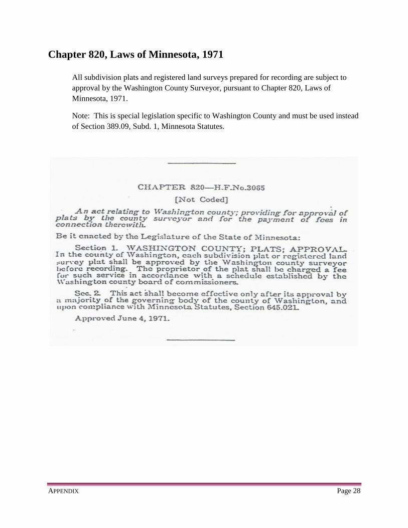
Chapter 820, Laws of Minnesota, 1971
All subdivision plats and registered land surveys prepared for recording are subject to
approval by the Washington County Surveyor, pursuant to Chapter 820, Laws of
Minnesota, 1971.
Note: This is special legislation specific to Washington County and must be used instead
of Section 389.09, Subd. 1, Minnesota Statutes.

APPENDIX Page 29
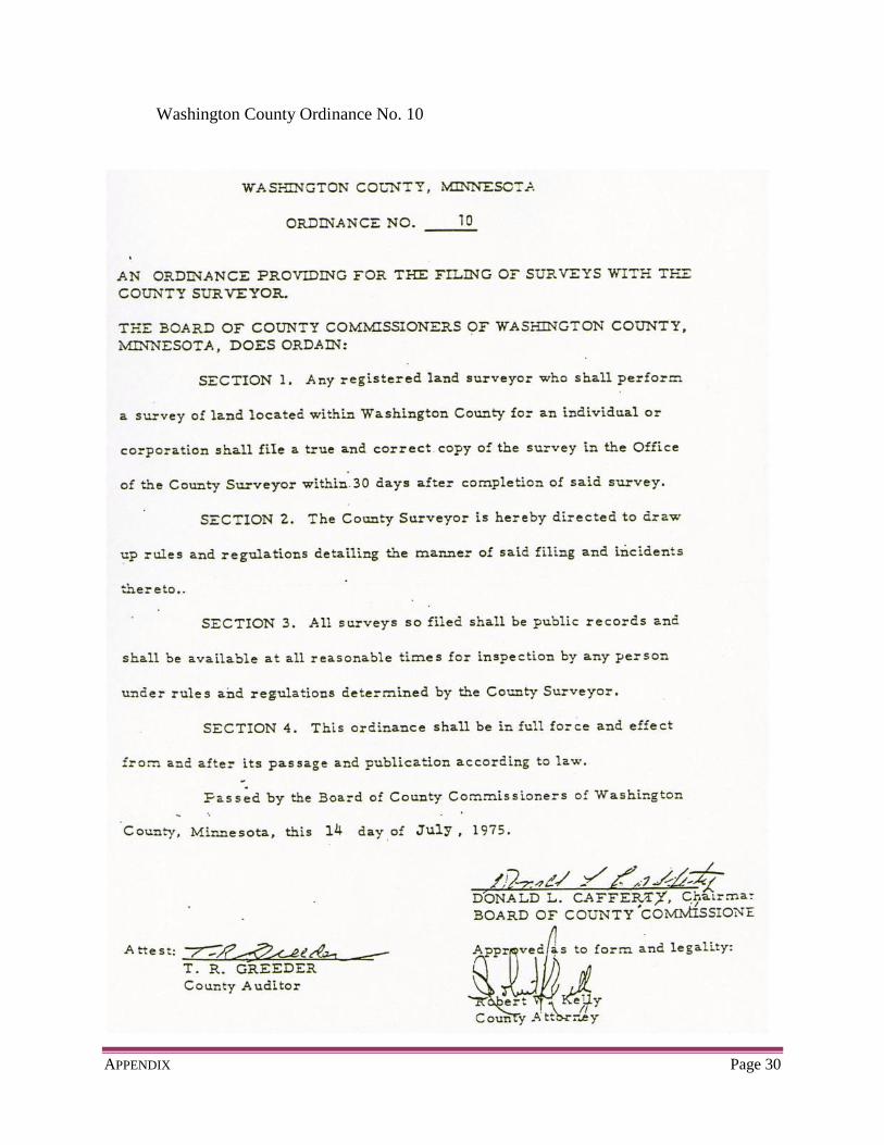
Filing Surveys in Washington County
In accordance with Section 389.08, Minnesota Statutes, Washington County Ordinance
No. 10 requires that any survey of land made by a licensed land surveyor be filed with the
County Surveyor.
Section 389.08, Minnesota Statutes, Filing of Surveys in Certain Counties
“In any county in which there is a county surveyor who maintains an office on a full-
time basis in a building maintained by the county for county purposes, the county
board may by ordinance adopted in accordance with section 375.51, require that a
licensed land surveyor who performs a survey of land for an individual or corporation
must file a true and correct copy of the survey in the office of the county surveyor
within 30 days after completion of the survey. The county surveyor shall determine
the manner of filing, and all incidents thereof. All surveys so filed are public records
and must be made available by the county surveyor at all reasonable times for
inspection by any person.”
See Washington County Ordinance No. 10 on page 30 of this Appendix.
Certificates of Survey on file
The County Surveyor maintains a record of each survey of land that is filed by a licensed
land surveyor. These land surveys are available for public view during offices hours.
Copyright laws apply. Only those surveys made before March 1, 1989 can be
photocopied. All other surveys are copyright protected.
APPENDIX Page 30
Washington County Ordinance No. 10

APPENDIX Page 31
Minnesota Statutes § 505.03 Subd. 2 Flow Chart

APPENDIX Page 32
Plat Review by Transportation Department(s)
If land being platted abuts a State Highway:
Submit the proposed plat to the Minnesota Commissioner of Transportation for
written comments and recommendations.
[Section 505.03, Subd. 2, Minnesota Statutes]
Development Reviews
MnDOT Metro Division
Waters Edge
1500 West County Road B-2
Roseville, MN 55113
If land being platted abuts a County Road or County State Aid Highway:
Submit the proposed plat to the Washington County Highway Engineer for
written comments and recommendations.
[Section 505.03, Subd. 2, Minnesota Statutes]
Transportation Engineer
Washington County Public Works Dept.
11660 Myeron Road North
Stillwater, MN 55082-9573

APPENDIX Page 33
Watershed District Map

APPENDIX Page 34
Minor Subdivision Plat Each City and Township in Washington County have their own process for
subdivisions of land. Please consult with the City or Township in which the land is
located.

APPENDIX Page 35
Local Planning Commission Review and Approval
Cities and Townships that require approval from their local Planning Commission and
signatures on the final plat mylars are shown below. Please confirm with local
authorities, since requirements may change. Use the signature block shown on page 7.
Cities:
Afton
Bayport
Birchwood
Cottage Grove
Dellwood
Forest Lake
Hastings
Lake Elmo
Lake St. Croix Beach
Lakeland
Lakeland Shores
Landfall
Marine on St. Croix
Newport
Oak Park Heights
Oakdale
Pine Springs
Scandia
St. Mary’s Point
Stillwater
White Bear Lake
Townships:
Grey Cloud Island
May
Stillwater
West Lakeland
APPENDIX Page 36
Uniform Street Naming and Property Numbering System
APPENDIX Page 37
Map of Office Location