addendum and initial study/environmental checklist to eir
TRANSCRIPT
Addendum & Initial Study/ Environmental Checklist To the Final Subsequent Environmental Impact Report
Prepared for the Existing B-18 Class I/Class II Landfill
Expansion Project Kettleman Hills Facility
Chemical Waste Management, Inc. May 21, 2013
May 21, 2013
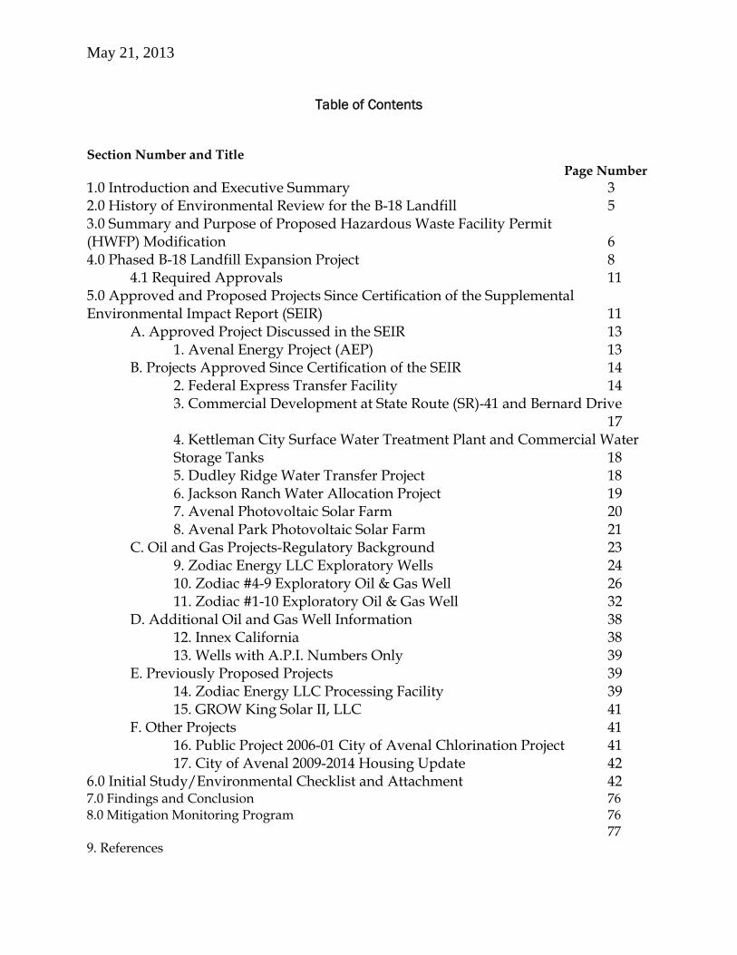
Table of Contents
Section Number and Title Page Number 1.0 Introduction and Executive Summary 3 2.0 History of Environmental Review for the B-18 Landfill 5 3.0 Summary and Purpose of Proposed Hazardous Waste Facility Permit (HWFP) Modification 6 4.0 Phased B-18 Landfill Expansion Project 8 4.1 Required Approvals 11 5.0 Approved and Proposed Projects Since Certification of the Supplemental Environmental Impact Report (SEIR) 11 A. Approved Project Discussed in the SEIR 13 1. Avenal Energy Project (AEP) 13 B. Projects Approved Since Certification of the SEIR 14 2. Federal Express Transfer Facility 14 3. Commercial Development at State Route (SR)-41 and Bernard Drive 17
4. Kettleman City Surface Water Treatment Plant and Commercial Water Storage Tanks 18 5. Dudley Ridge Water Transfer Project 18 6. Jackson Ranch Water Allocation Project 19 7. Avenal Photovoltaic Solar Farm 20 8. Avenal Park Photovoltaic Solar Farm 21
C. Oil and Gas Projects-Regulatory Background 23 9. Zodiac Energy LLC Exploratory Wells 24 10. Zodiac #4-9 Exploratory Oil & Gas Well 26 11. Zodiac #1-10 Exploratory Oil & Gas Well 32 D. Additional Oil and Gas Well Information 38 12. Innex California 38 13. Wells with A.P.I. Numbers Only 39 E. Previously Proposed Projects 39 14. Zodiac Energy LLC Processing Facility 39 15. GROW King Solar II, LLC 41 F. Other Projects 41 16. Public Project 2006-01 City of Avenal Chlorination Project 41 17. City of Avenal 2009-2014 Housing Update 42 6.0 Initial Study/Environmental Checklist and Attachment 42 7.0 Findings and Conclusion 76 8.0 Mitigation Monitoring Program 76 77 9. References

3
1.0 Introduction and Executive Summary This Addendum and Initial Study/Environmental Checklist, including the attached supporting technical documents, were prepared pursuant to the California Environmental Quality Act (CEQA) (Pub. Resources Code, Section 21000 et seq.) for purposes of the Department of Toxic Substances Control’s (DTSC’s) consideration of Chemical Waste Management, Inc.’s (CWMI) proposed modification to its existing Hazardous Waste Facility Permit (HWFP) (No. 02-SAC-03) for the B-18 Hazardous Waste Disposal Landfill (the Project or KHF Project) (State Clearinghouse No. 2005041064), located at the Kettleman Hills Facility (KHF). CWMI submitted an application for a permit modification on December 12, 2008. DTSC is acting as a Responsible Agency under CEQA for purposes of the permit modification. (Cal. Code Regs., title 14, section 15096, 15381 (CEQA Guidelines).)
This Addendum and Initial Study/Environmental Checklist is prepared as an addition to the Final Subsequent Environmental Impact Report (Final SEIR) prepared for the KHF Project and certified by the Kings County Board of Supervisors, as the Lead Agency under CEQA, on December 22, 2009 State Clearinghouse Number 2005041064. (CEQA Guidelines, section 15164.)
Part of the information in this document is derived from a draft submitted by CH2M-Hill and subsequently modified by the Department of Toxic Substances Control to reflect its independent judgment and findings related to the potential impacts of the proposed B-18 Class I/Class II Landfill Expansion Project Kettleman Hills Facility, Chemical Waste Management, Inc. Pub. Resources Code, Section 21166 provides that when an environmental impact report has been prepared and certified for a project, no subsequent or supplemental environmental impact report shall be required by the lead agency or by any responsible agency, unless one or more of the following events occurs:
a. Substantial changes are proposed in the project, which will require major revisions of the environmental impact report.
b. Substantial changes occur with respect to the circumstances under which the project is being undertaken which will require major revisions in the environmental impact report.
c. New information, which was not known and could not have been known at the time the environmental impact report was certified as complete, becomes available.
Pub. Resources Code, Section 21068 defines “Significant effect on the environment” as a substantial, or potentially substantial, adverse change in the environment. CEQA Guidelines, section 15382 further defines, in relevant part, a “Significant effect on the environment” as meaning a substantial, or potentially substantial, adverse change in any of the physical conditions within the area affected by the project, including land, air, water, minerals, flora, fauna, ambient noise, and objects of historic or aesthetic significance.
Consequently, once an Environmental Impact Report (EIR) has been certified for a project, no subsequent EIR is required under CEQA unless, based on substantial evidence (CEQA Guidelines, section 15162, subd, (a)):
4
1. Substantial changes are proposed in the project which will require major revisions of the previous EIR . . . due to the involvement of new significant environmental effects or a substantial increase in the severity of previously identified significant effects;
2. Substantial changes occur with respect to the circumstances under which the project is undertaken which will require major revisions of the previous EIR . . . due to the involvement of new significant environmental effects or a substantial increase in the severity of previously identified significant effects; or
3. New information of substantial importance, which was not known and could not have been known with the exercise of reasonable diligence at the time the previous EIR was certified as complete . . . shows any of the following:
a. The project will have one or more significant effects not discussed in the previous EIR;
b. Significant effects previously examined will be substantially more severe than shown in the previous EIR;
c. Mitigation measures or alternatives previously found not to be feasible would in fact be feasible, and would substantially reduce one or more significant effects of the project, but the project proponents decline to adopt the mitigation measure or alternative; or
d. Mitigation measures or alternatives which are considerably different from those analyzed in the previous EIR would substantially reduce one or more significant effects on the environment, but the project proponents decline to adopt the mitigation measure or alternative. 1
A lead or responsible agency shall prepare an addendum to a previously certified EIR if some changes or additions are necessary but none of the conditions described in CEQA Guidelines, section 15162 calling for preparation of a subsequent EIR have occurred. (CEQA Guidelines, section 15164, subd, (a).)
CEQA allows subsequent responsible agencies issuing a discretionary approval to restrict review of modifications to a previously approved project to the incremental effects associated with the proposed modifications, compared against the anticipated effects of the previously approved Project at build-out. In other words, if the project under review constitutes a modification of a previously approved project which was subject to prior final environmental review, the “baseline” for purposes of CEQA is adjusted such that the originally approved project is assumed to exist. (See Melom v. City of Madera (2010) 183 Cal.App.4th 41 (city properly relied on an addendum in analyzing changes to a site plan for a proposed shopping center); Benton v. Board of Supervisors (1991) 226 Cal. App. 3d 1467, 1475-1482 (upholding county’s adoption of addendum to negative declaration for revision to winery project’s location; county could restrict its review to the incremental effects of the relocation, rather than having to reconsider the overall impacts of the winery); Temecula Band of Luiseño Mission Indians v. Rancho California Water Dist. (1996) 43 Cal. App. 4th 425 (water district properly focused analysis of
1 / A lead or responsible agency could also choose to prepare a supplement to an EIR rather than a subsequent EIR if: (1) any of the conditions described in the CEQA Guidelines, section 15162 would require the preparation of a subsequent EIR, and (2) only minor additions or changes would be necessary to make the previous EIR adequately apply to the project in the changed situation. (See CEQA Guidelines, section 15163, subd. (a).)
5
pipeline project relocation solely on the incremental effects of relocating the pipeline, and did not need to consider the cumulative effects of the pipeline in conjunction with the program); Fund for Environmental Defense v. County of Orange (1988) 204 Cal. App. 3d 1538, 1542-1552 (finding no substantial evidence that changed circumstances resulted in the Project causing new significant adverse impacts or a substantial increase in previously identified significant impacts).
Based on these considerations and after considering the evidence in the record, including new additional projects (Additional Projects) proposed or approved within the County since certification of the Final SEIR, and after consideration of the attached Initial Study/Checklist, DTSC determined that preparation of an Addendum to the Final SEIR for the B-18 Hazardous Waste Disposal Permit Modification Project was appropriate to comply with CEQA. Section 15164 (a) of the CEQA Guidelines provides that an addendum to a Final EIR is the appropriate documentation when the agency has determined that none of the conditions described in CEQA Guidelines, sections 15162 or 15163 exist. Although CEQA Guidelines, section 15164 (c) states that an addendum need not be circulated for public review and comment, DTSC decided to voluntarily circulate the Addendum with the draft HWFP modification. Subsection (d) requires the decision making body to consider the Addendum with the Final EIR prior to making a decision on the project and subsection (e) describes the documentation required for the addendum; this Initial Study/Checklist and Addendum is the means for providing the required documentation.
2.0 History of Environmental Review for the B-18 Landfill The KHF is located in rural western Kings County, California, approximately 3.5 miles southwest of Kettleman City, 6.5 miles southeast of the city of Avenal, and about 2.5 miles west of Interstate (I-) 5. KHF is located on approximately 1,600 acres, with 474 acres permitted for ongoing treatment, storage, and disposal operations for hazardous and municipal solid waste. The applicant, CWMI acquired KHF in 1979. In April 1985, the County certified an EIR and approved a project to expand the then 1,280 acre KHF site to 1,600 acres, permitting three new waste disposal areas (B-17 Landfill, B-18 Landfill and B-19 Landfill.) The April 1985 EIR provided the basis for approval of Conditional Use Permit (CUP) No. 1412.
In 2004, the County issued a Notice of Preparation (NOP) of a Subsequent Environmental Impact Report (SEIR) for the B-18/B-20 Hazardous Waste Landfill Project, including consideration of CUP No. 05-10 for expansion of the existing B-18 Hazardous Waste Landfill by 14 acres (and closure), and construction of a new B-20 Hazardous Waste Landfill of 63 acres (and closure) through 2042 at current existing levels of operation ( Pub. Resources Code, Section 21166; CEQA Guidelines, section 15162.) At that time, the then proposed B-17 Class II/III Landfill project was also included in the NOP but was later removed after the County found it to have “independent utility” under CEQA. A Revised NOP was issued in August 2005, clarifying that, compared to the previously distributed 2004 NOP, the Project had been modified to include only the Class I/II B-18 Landfill expansion and the new Class I/II B-20 Landfill.
In 2008, after circulation of the B-18/B-20 Draft SEIR, the project description was refined, a traffic mitigation measure was clarified, and information regarding toxic air emissions was added to the SEIR. This Revised Project Description and Analysis was noticed and recirculated for 45-days of public review and comment in May 2008.
6
In 2009, in response to comments received on the B-18/B-20 Draft SEIR, the County determined that portions of the Draft SEIR should be recirculated. In accordance with section 15088.5(c) of the CEQA Guidelines, the Recirculated Portions of the Draft SEIR contains those sections of the previously released Draft SEIR in which significant new information was provided (e.g., Section 3.1.2 – Cumulative impact analysis of the Avenal Energy Center Project; revised Section 3.8 – Hydrology and Water Quality; and revised Section 3.11 – Transportation and Traffic). The County noticed and recirculated the Recirculated Portions of the Draft SEIR for another 45-days of public review and comment in May 2009.
The County released the B-18/B-20 Final SEIR in October 2009 consisting of: (i) the March 2008 Draft SEIR; (ii) the May 2008 Revised Project Description and Analysis (Revised Project Description and Analysis); (iii) the May 2009 Recirculated Portions of the Draft SEIR (Recirculated SEIR); and (iv) the 2009 Final SEIR (Final SEIR), including appendices for each. In October 2009, after holding two public hearings, the Kings County Planning Commission approved the Project after certifying the B-18/B-20 Final SEIR, which was appealed to the Board of Supervisors on October 27, 2009. The Board held a hearing on the appeal of the Planning Commission’s approval of the Project on December 7, 2009. After holding a second hearing, in December 2009, the Kings County Board of Supervisors denied the appeal and granted the CUP for the project. On January 21, 2010, two groups of petitioners filed a Verified Petition for Writ of Mandate and Complaint for Declaratory and Injunctive Relief challenging the approval of the B-18/B-20 Landfill expansion project and certification of the Final SEIR. A hearing on the merits of Petitioners’ CEQA claims was held on November 22, 2010. The superior court for the County of Kings issued an order denying Petitioners’ petition for writ of mandate on the merits on January 3, 2011. Notice of Entry of Final Judgment denying all of petitioners’ claims on the merits was entered on January 27, 2011. On appeal, the Fifth District Court of Appeal heard oral arguments on June 19, 2012, and a decision was entered on July 3, 2012 affirming the Trial Court’s decision for the Final SEIR. The California Supreme Court denied review on September 26, 2012.
3.0 Summary and Purpose of Proposed HWFP Modification The proposed expansion of the B-18 Landfill requires a Class III modification of the existing Hazardous Waste Facility Permit (HWFP) (No. 02-SAC-03) by DTSC, pursuant to California Health and Safety Code (HSC) Section 25200 (California’s Hazardous Waste Control Act (HWCA), originally adopted in 1972 (HSC Section 25101 et seq., and largely implemented in lieu of the federal Resource Conservation and Recovery Act of 1976), for the disposal of hazardous waste at the proposed B-18 Landfill expansion and new B-20 Landfill. In determining whether to issue the HWFP modification, DTSC may exercise discretion and impose conditions as provided in HSC Section 25200 et seq. and the implementing code of regulations found in California Code of Regulations (Cal. Code Regs.), title 22, including section 66271.5, subdivision (c)(1)-(4) (Draft Permits). Each permit issued must also include terms and conditions as the Department determines necessary to protect human health and the environment from hazardous waste treatment, storage and disposal related activities. (HSC Section 25200; Cal. Code Regs., title 22, section 66270.32.) DTSC’s discretion in deciding whether to issue and, if so, how to condition issuance of the HWFP modification is therefore proscribed by statute (i.e., HSC Section 25200 et seq.) and the implementing regulations. DTSC is therefore a responsible agency under CEQA, acting as a permitting authority over an aspect of the Project. (Pub. Resources Code, Section 21069; CEQA Guidelines, sections 15096 and 15381).
7
A responsible agency complies with CEQA by considering and commenting on the EIR prepared by the lead agency, and by reaching its own conclusions regarding whether and how to approve the project as it pertains to the scope of the responsible agency’s authority. (CEQA Guidelines, section 15069, subds. (a), (d).). DTSC reviewed and commented on the Draft SEIR and revised Draft SEIR sections prepared by the County, and received responses to those comments from the County as part of the Final SEIR. 2 DTSC relied on the Final SEIR for the B-18/B-20 Hazardous Waste Landfill project for reviewing and analyzing the proposed modification of the existing HWFP, and in determining whether to prepare an addendum or other environmental document. 3
As the certified Final SEIR for the B-18/B-20 Hazardous Waste Landfill project analyzes the impacts of the expansion of the B-18 Landfill, and because the HWFP modification does not propose to alter the net maximum permitted capacity of the B-18 Landfill expansion as analyzed in the Final SEIR and approved by the County, the Final SEIR encompasses the activities anticipated under the HWFP modification.
The applicant is requesting implementation of a phased build-out of the B-18 Landfill expansion (dubbed the Phase III expansion) analyzed in the SEIR, as described below, to provide for earlier use of a portion of the B-18 Landfill expansion (Phase IIIA) while construction of the remaining portion of the liner system is completed (Phase IIIB). This Addendum and Initial Study/Environmental Checklist was prepared to evaluate the environmental effects of the proposed HWFP modification, including the phasing of the B-18 Landfill. Through preparation of the Addendum and Initial Study/Environmental Checklist to the Final SEIR, the Final SEIR was found to be sufficient in accordance with CEQA. (CEQA Guidelines, sections 15162, 15164, subd. (a) (a responsible agency shall prepare an addendum to a previously certified EIR if some changes or additions are necessary but none of the conditions described in section 15162 calling for preparation of a subsequent EIR have occurred).) The Final SEIR, including the appendices, Draft SEIR and revised and recirculated sections of the SEIR (SCH No. 2005041064) are hereby incorporated by reference in their entirety as if fully set forth herein. (CEQA Guidelines, section
2 / If a responsible agency believes a final EIR prepared by the lead agency is not adequate for use by the responsible agency, the responsible agency must either: (1) take the issue to court within 30 days after the lead agency files a notice of determination; (2) be deemed to have waived any objection to the adequacy of the EIR; (3) prepare a subsequent EIR if permissible under section 15162; or (4) assume the lead agency role as provided in CEQA Guidelines, section 15052(a)(3). (CEQA Guidelines, section 15096, subd. (e).) 3/ When a lawsuit or appeal has been filed challenging an EIR for noncompliance with CEQA, a responsible agency is required to treat the challenged EIR as legally valid unless and until the court reaches a final determination that the document is inadequate. (Pub. Resources Code, Section 21167.3; see also CEQA Guidelines, sections 15231 and 15233; City of Redding v. Shasta County Local Agency Formation Commission (1989) 209 Cal.App.3d 1169, 1178 (where petitioner had attacked lead agency’s environmental document before responsible agency had acted on the approval, responsible agency was prohibited from taking steps toward production of new environmental document).) An approval granted by a responsible agency in this situation, however, provides only permission to proceed with the project at the applicant’s own risk prior to final decision on the lawsuit. (CEQA Guidelines, section 15233, subd. (b); see also Pub. Resources Code, Section 21167.3, subd. (b).)
8
15150.) The SEIR is available for inspection at DTSC or through the County of Kings Community Development Agency.
4.0 Phased B-18 Landfill Expansion Project The certified Final SEIR analyzes the expansion of the existing B-18 Landfill to add an additional 4.9 million cy of airspace to the currently permitted 10.7 million cy of air space, for a total permitted capacity of approximately 15.6 million cy. (SEIR, Revised Project Description and Analysis, pp. 2-1 to 2-3.) The SEIR considered the B-18 Landfill expansion (Phase III) would occur in two phases, and would include construction of a berm around the B-18 Landfill perimeter to provide support for the expansion. (SEIR, DSEIR, p. 2-7.)
The existing waste footprint of the B-18 Landfill is 53 acres. The expansion would add 14 acres to the waste footprint of the existing B-18 Landfill, for a total of 67 acres. A storm water retention basin, soil buttresses and perimeter road for the existing B-18 Landfill totals 16 acres, bringing the total area of disturbance for the existing B-18 Landfill to 69 acres. With the proposed lateral and vertical expansion, the total area of disturbance of the expansion of the B-18 Landfill is 79 acres. (SEIR, Revised Project Description and Analysis, p. 2-3.) As part of the design for the vertical and lateral Phase III expansion of the B-18 Landfill, to maintain the maximum flow rate through the geocomposite drainage layer/geotextile above the secondary FML, the geosynthetic clay liner (GCL) will be eliminated from the side-slope liner design. The refined side-slope liner system is the same as the existing side-slope liner at the existing B-18 Landfill. A GCL below the secondary FML may be allowed in conjunction with a low-permeability soil liner. Elimination of the GCL maximizes the flow rate through the geocomposite drainage layer/geotextile, thus allowing prompt removal of liquids from the landfill. The elimination of the GCL from the side-slope liner system for the Phase III expansion of the B-18 Landfill does not result in an increased risk to the environment as the primary and secondary FML components of the side-slope liner provide full containment. Based on this design, the side-slope liner system for the Phase III expansion of the B-18 Landfill will consist of the following components: • 2-foot operations layer • Geocomposite drainage layer • 60-mil textured flexible membrane liner (FML) • Geocomposite drainage layer/Geotextile • 60-mil textured FML • 3-foot soil liner (K ≤ 1x10⁻⁷ cm/sec) • Prepared Subgrade (SEIR, Revised Project Description and Analysis, p. 2-4.) As discussed in Technical Report A (Engineering & Design Report, B-18 Class I Landfill Phase III Expansion and Final Closure, prepared by Golder Associates Inc.) (August 2011) which is incorporated by reference, construction of the Phase III liner system will be completed in one continuous construction sequence in accordance with the certified SEIR. Procedures used to construct the Phase III clay liner will be the same as those that were used to construct the Phases I and II clay liner. To ensure the ability for B-18 to continue operating and to facilitate early use
9
of a first phase of the expansion area, KHF will first submit a CQA certification report for a 3.5 acre area in the northwestern portion of the expansion (referred to as Phase IIIA). Once approval from DTSC and other required regulatory agencies is obtained, the site will begin placement of waste within the initial approved limits. Meanwhile, construction of the remaining portions of the liner system (hereafter referred to as Phase IIIB) will continue and would be expected to be completed within 6 months of the initiation of waste placement in Phase IIIA. A separate CQA certification report will be prepared and submitted to DTSC for Phase IIIB.
Phase IIIA and IIIB will be constructed in accordance with the specifications and CQA Plan contained in the Engineering and Design Report. (See Technical Report A, including technical appendices). The Technical Reports, A, B and C, listed below, are incorporated herein by reference and are available for review at the locations noted in Section 6.0, page 42 below or online at: www.dtsc.ca.gov/HazardousWaste/Projects/CWMI_Kettleman.cfm.
Technical Reports: A. Engineering and Design Report, B-18 Class I Landfill Phase III Expansion and Final Closure August 2011. Golder Associates, Inc. B. Slope Stability Analysis Report, Kettleman Hills Facility Landfill Unit B-18, Kettleman City, Kings County, California. May 2011. Hushmand Associates, Inc. C. Surface Water Hydrology Calculations, Kettleman Hills Facility Landfill Unit B-18, Kettleman City, Kings County, California. August 2011. Golder Associates, Inc.
The submittal of the two CQA reports does not modify the construction requirements for the liner system as described herein, in the SEIR and as required by the California Code of Regulations. (See e.g., Cal Code Regs., title 22, section 66264.301).
The design of Phase III ties into the existing leachate collection and removal system (LCRS). The Phase IIIA LCRS will function as designed to continue ensuring, as with other areas of the landfill, that the leachate depth over the liner of Phase III does not exceed 30 cm (one foot). (See Cal. Code Regs., title 22, section 66264.301.). Specifically, Phase IIIA will be constructed such that leachate from Phase IIIA will be able to flow directly into the Phase IA LCRS. Thus, except for the temporary lined containment berm at the edge of Phase IIIA/IIIB (see Sheet C-4A in Technical Report A, Appendix A.2), no interim control measures will be required. Stormwater contained on the north side of this temporary berm (i.e., between the berm and the Phase IIIA waste mass) will be treated as leachate and will be handled in the same manner as leachate that is collected in the existing B-18 leachate storage tanks (located on the concrete riser pads). (See also Technical Report A, Sections 4.8.1, 4.9.6.) Monitoring of the primary and secondary LCRS and vadose zones will continue during construction of Phase III. (Technical Report A, Sections 4.8.2-4.8.4.)
An interim 10-foot high soil berm will be constructed between Phase IIIA and Phase IIIB along the area of the existing perimeter road. (See Technical Report A, pp. 29, 41; see also SEIR, Section 3.3.3.3.1, Table 2-3).) This berm will provide a physical delineation between the two phases and will provide run-on and run-off containment of stormwater from the worst case 24-hour 100-year probable maximum precipitation (PMP) storm event. (See Cal Code Regs., title 22, section 66264.25; Technical Report A, pp. 26, 29, 60-64.) This temporary berm will prevent
10
stormwater run-off from the 24-hour PMP storm event from leaving the Phase IIIA area. It will also prevent stormwater run-on from a 24-hour PMP event from entering the Phase IIIA area from the south. (See Technical Report A, Sections 5.5.5 and 5.5.4.) The stormwater run-off volume from the 24-hour, PMP storm event captured on the north side of the proposed interim Phase IIIA drainage berm is calculated to be 24,500 cubic feet. The proposed interim Phase IIIA berm will be constructed to a height of 10 feet and will have a capacity of 52,100 cubic feet (assuming 1 foot of freeboard). Therefore, the proposed interim Phase IIIA drainage berm will have sufficient capacity to contain the flows from the 24-hour, PMP event with a freeboard greater than 1 foot. The existing Northeast B-18 Containment Basin has a capacity of approximately 30 acre-feet. If the 24-hour, PMP storm event occurs during the construction of Phase III (i.e., before the South Containment Basin comes online), it is predicted that runoff to the existing NE B-18 Containment Basin would exceed its capacity by approximately 14 acre-feet. A 21-inch orifice outlet will be set approximately 3 feet below the top of the existing NE B-18 Containment Basin berm to prevent overtopping of this basin during a 24-hour PMP event should one occur. The peak flows from the orifice outlet would be 17 cubic feet per second (cfs). In the event of a 24-hour PMP event, the excess water from the outlet system would be conveyed by gravity pipe to the site’s existing East Retention Basin located approximately 2,000 feet to the north. The capacity of the existing East Retention Basin is approximately 50 acre feet. The East Retention Basin has a spillway in the event flow to the basin is greater than the capacity and the water would be released. This is a permitted NPDES discharge point. Stormwater from Phase IIIB would be unable to run onto Phase IIIA during construction of Phase IIIB because the top of the temporary Phase IIIA berm will be much higher than the high point of the Phase IIIB floor bench. (See Technical Report A, Section 4.9.1.)
The design and size of the berm is consistent with the SEIR and impacts considered therein (See e.g., Draft SEIR, Sections 2.10.4.1, 3.3.3.3.1) and all applicable regulatory requirements. It is also consistent with historic onsite stormwater drainage control measures. (See Draft SEIR, Section 2.10.4.1, Table 2-7.) As shown in the attached Golder analysis and supporting studies (i.e. Technical Report A, Appendix J.3) the berm has been sized to contain the 24-hour PMP event; thus, no pumping from this berm would be required to prevent overtopping during a 24-hour PMP storm event. Other stormwater controls, such as the perimeter channel and brow ditches, within the watershed of Phase IIIA will be constructed for run-on and run-off control during the interim period. The South Containment Basin will be constructed during Phase IIIB. A temporary intermediate fill slope condition could also result from construction of Phase IIIA for a short time. A cross section through the temporary slope was evaluated to ensure static stability and compliance with applicable requirements. (See Technical Report A, pp. 57-58 and Appendix H.4.) A static stability analysis was conducted for the Phase IIIA intermediate waste slope. The result in Table 5.2 for this condition is a static factor of safety of 1.5 which is considered acceptable. (Technical Report A, p. 58.) The Phase IIIA stability analyses were performed for the south-facing 2H:1V interim waste slope. The remaining waste slopes formed during Phase IIIA will be built to final closure grades as analyzed previously as part of the final closure stability analysis. (See Figure 5.3.)
4.1 Required Approvals
11
DTSC – HWFP Part B Permit/Class III Modification
The existing HWFP (No. 02-SAC-03) allows for a total maximum disposal capacity within the B-18 Landfill of 10.7 million cy (HWFP, p. 28). The B-18/B-20 Hazardous Waste Disposal Landfill project, approved by the Kings County Board of Supervisors in December 2009, pursuant to a CUP (County Resolution No. 09-073) and the certified Final SEIR, will add: (i) 14 acres (for 67 total acres); and (ii) 4.9 million cy of total additional waste disposal capacity to the existing B-18 Landfill. Pursuant to California Health and Safety Code (HSC) Section 25200, a Class III modification of the existing HWFP (No. 02-SAC-03) is required before hazardous waste can be disposed of within the B-18 Landfill expansion area.
In addition to DTSC, other agencies may still need to issue permits for the construction and operation of the existing B-18 Landfill at KHF. Those agencies may also rely on the information contained in the Subsequent EIR and this Addendum for their respective approvals. Other responsible or trustee agencies for the Project include:California Regional Water Quality Control Board – Central Valley Region for Waste Discharge Requirements (WDRs) under Cal. Code Regs., title 23.
Kings County Department of Public Health – as the Local Enforcement Agency (LEA) for Cal. Code Regs., title 14 – Non-hazardous Non-putrescible Industrial Solid Waste Registration Permit.
San Joaquin Valley Unified Air Pollution Control District – Title V Permit under the Federal Clean Air Act and Authorization to Construct under District Rule 2010.
U.S. Environmental Protection Agency – Toxic Substances Control Act (TSCA) Permit.
5.0 Approved and Proposed Projects Since Certification of the SEIR.
At the time the second Notice of Preparation (NOP) was issued for the B-18/B-20 Project by the Kings County Planning Agency as the Lead Agency under CEQA, the past, present and reasonably foreseeable future projects with the potential to cause related cumulative impacts, and therefore included in the SEIR, were the: Avenal Landfill Expansion project, Westlake Farms Co-Composting Facility, SR-41 Rehabilitation Project, and the then proposed Quay Valley Ranch Specific Plan (or the “new town project”) which, as explained below, no longer has an active application on file with the County and, therefore, is no longer being processed. (telephone call with Sandy Roper, Principal Planner, County of Kings (Jan. 3, 2012).) In 2009, in response to a comment received from the Kings County Department of Public Health on the Draft SEIR, the Avenal Energy Project was included and analyzed in the Recirculated Portions of the Draft SEIR and the Final SEIR. Because an Application for Certification of the Avenal Energy Project had, at that time, not yet been filed with the California Energy Commission (Energy Commission), and was not filed until February 28, 2008, the County did not originally identify the Avenal Energy Project as a reasonably foreseeable future related project under CEQA in the cumulative impacts analysis of the Draft SEIR. Additional consideration of the Avenal Energy Project by DTSC is included below.
This Addendum includes new information regarding: projects for which applications were either filed with the County after certification of the SEIR and remain pending; and projects which have since been approved by the County or another agency such as the California
12
Department of Conservation Division of Oil, Gas, and Geothermal Resources (DOGGR) (collectively referred to below as “Additional Projects”).) Generally, under CEQA, information appearing after project approval by the lead agency does not require reopening of that approval. (CEQA Guidelines, section 15162, subd. (c).) In fact, once an EIR is certified there is a statutory presumption against additional environmental review. (See San Diego Navy Broadway Complex Coalition v. City of San Diego (2010) 185 Cal.App.4th 924; Pub. Resources Code, Section 21166.) DTSC has nevertheless consulted with Kings County and various State agencies to identify and consider the Additional Projects described below as part of its analysis. As explained herein, there have been no substantial changes to the Project since approval by the County Board of Supervisors which would require major revisions of the SEIR. The inquiry under subdivision (a)(1) of CEQA Guidelines section 15162 and Public Resources Code Section 21166, subdivision (a), is therefore inapplicable. (Pub. Resources Code, section 21166, subd. (a); CEQA Guidelines, section 15162, subd. (a)(1).) Consequently, this Addendum focuses on the Additional Projects described below within the context of:
(i) Whether there have been “substantial changes” with respect to the circumstances under which the Project would be undertaken which would require “major revisions of the previous EIR” due to new significant environmental effects, or a substantial increase in the severity of previously identified significant effects (CEQA Guidelines, section 15162(a)(2)); or
(ii) Whether “new information of substantial importance” which was not known and
could not have been known with the exercise of reasonable diligence at the time the prior SEIR was certified, shows:
(A) the Project will have one or more “significant effects not discussed in the
previous EIR;” (B) “Significant effects previously examined will be substantially more
severe” than shown in the previous SEIR; (C) Mitigation measures or alternatives previously found not to be feasible
would in fact be feasible and would substantially reduce one or more significant effects of the project, but the project proponents decline to adopt the mitigation measure or alternative; or
(D) Mitigation measures or alternatives which are considerably different from those analyzed in the previous EIR would substantially reduce one or more significant effects on the environment, but the project proponents decline to adopt the mitigation measure or alternative.
(CEQA Guidelines, section 15162, subdivisions (a)(2)-(3)(A)-(D); see also Pub. Resources Code, Section 21166, subd. (b)-(c).)
As explained herein, DTSC has found no evidence warranting preparation of a Supplemental or Subsequent EIR to the previously certified SEIR for the revised HWFP pursuant to Pub. Resources Code, Section 21166 and CEQA Guidelines section 15162. In reaching this determination, DTSC considered a broad range of Additional Projects which have since been brought forward in the County. The projects discussed below have or may have regional effects on air quality, greenhouse gas, and transportation in addition to other project effects. At the time the Final SEIR was issued, additional projects were anticipated for the Kings County,
13
Kettleman region. Significant and unavoidable impacts to air quality, greenhouse gas, lifetime cancer risk under a hypothetical worst case scenario at the Kettleman Hills Facility property boundary, and transportation impacts were analyzed as significant and unavoidable by Kings County in the Final SEIR. The impacts of the B-18 Hazardous Waste Disposal Permit Modification Project to expand the facility are set forth in the Environmental Checklist within this Addendum, which includes the specific mitigation measures adopted for the Project by Kings County. These mitigation measures are intended to reduce project impacts in specific ways, and for air quality, greenhouse, and transportation, to the extent feasible. Since issuance of the Final SEIR, additional projects have been proposed or have been approved; however, as stated earlier, these projects do not change the conditions anticipated in the Final SEIR, and no changes to the significance findings or conclusions of the Final SEIR are needed. The projects described below do not constitute new information of substantial importance showing the KHF Project will result in one or more significant effects not identified in the SEIR, or that the significant impacts previously examined will be substantially more severe, either directly or cumulatively, than shown in the prior Final SEIR (CEQA Guidelines, section 15162, subd (a)(3). There is no aspect to the projects listed below that would constitute a “substantial change” with respect to the circumstances under which the Project would be undertaken such that major revisions of the SEIR would be required. (CEQA Guidelines, section 15162, subd (a)(2). A. APPROVED PROJECT DISCUSSED IN THE SEIR
1. Avenal Energy Project (AEP) As explained in the SEIR, the Avenal Energy Project (AEP) is a 600-megawatt natural gas-fired combined-cycle power plant to be located in the City of Avenal, just south of the Fresno County line, two miles east of Interstate-5, and over 7 miles from the Project site. The AEP will be built on approximately 34 acres of a 148-acre site. Commercial operation of the plant is anticipated to begin in June of 2012. (See Recirculated Portions of the Draft SEIR (May 2009), pp. 3-2 thru -3-16.) The California Energy Commission (CEC) approved the AEP in December 2009. (See CEC Adoption Order No. 09-1216-04.) USEPA Region 9 issued a prevention of significant deterioration (PSD) permit for the AEP on May 27, 2011. On August 18, 2011, the Environmental Appeals Board for USEPA denied a petition for review of the PSD filed by El Pueblo Para El Aire y Agua Limpio (El Pueblo) and Greenaction (Greenaction) for Health and Environmental Justice, among others. (See In Re: Avenal Power Center, LLC, PSD Appeal Nos. 11-02, 11-03 – 11-05 (Order Denying Review (Aug. 18, 2011)); see also Avenal Power Center, LLC v. U.S. EPA (2011) 787 F.Supp.2d 1 (requiring EPA to issue final decision on PSD permit application no later than August 27, 2011).) El Pueblo filed a petition for review under the Clean Air Act on November 4, 2011 in the United States Court of Appeals for the Ninth Circuit. The petition is pending. Although the Recirculated Portions of the Draft SEIR included the AEP as part of the cumulative impacts analysis under CEQA, DTSC has received comments from community members expressing concern that the Final SEIR did not evaluate the AEP appropriately. The concerns revolve around US EPA’s decision to issue the PSD and “grandfather” the permit to apply the then existing annual average National Ambient Air Quality Standards (NAAQS) under the Clean Air Act (CAA), including for concentrations of nitrogen oxides (versus the
14
hourly NO2 standard which became effective on April 12, 2010), and not to apply the newly enacted PSD requirements for greenhouse gas emissions (GHG). The pending petition for review filed against USEPA Region IX involves separate issues from those presented to the County when considering certification of the SEIR, and DTSC for purposes of its approval of the HWFP modification; namely, whether USEPA applied the proper NAAQS standards. The Final SEIR, which includes the Recirculated Portions of the Draft SEIR, was evaluated for the cumulative air quality impacts under CEQA Guidelines, section 15130 (governing the discussion of cumulative impacts). DTSC also considered the Application for Certification, California Energy Commission Avenal Energy Volumes I and II (TRC 2008). It is DTSC’s conclusion that the AEP discussion in the SEIR’s cumulative impacts analysis adequately assessed the AEP project impacts, and the SEIR did not understate the impacts of the Project in conjunction with the AEP based on the NAAQs standards used or on any other basis. (See Recirculated Portions of Draft SEIR, pp. 3-5 thru 3-16.) Rather than understate the cumulative impacts, the Recirculated Portions of the Draft SEIR concluded that because of the nonattainment designations of the San Joaquin Valley Air Basin, the KHF Project would result in a significant adverse impact to air quality from the ongoing contribution of criteria pollutants by allowing a continuation of existing hazardous waste treatment, storage and disposal operations at KHF. The Draft SEIR further concluded that ongoing contributions would also be cumulatively considerable to criteria pollutants such as PM10, and PM2.5 and to greenhouse gases (e.g., carbon dioxide, methane, and nitrous oxide). (Recirculated Portions of Draft SEIR, pp. 3-5 thru 3-6; 3-14 thru 3-15.) With implementation of the AEP, as designed to require offsets and installation of best available control technology (BACT), the SEIR found the AEP would not cause a new or substantial increase in the severity of the previously identified significant cumulative air quality impacts, and would not change the findings of the Draft SEIR. (Recirculated Portions of Draft SEIR, pp. 3-5 thru 3-6; 3-16.) There is no indication that the Recirculated Portions of the Draft SEIR considered cumulative impacts from the AEP using inapplicable standards, or otherwise understated the potential cumulative air quality impacts of the Project in addition to related projects such as the AEP. The AEP was evaluated in coming to this conclusion (See Final SEIR; Recirculated Portions of the Draft SEIR; TRC; Application for Certification of California Energy Commission Avenal Energy Vol. I). As stated previously, DTSC concludes that the AEP discussion in the SEIR’s cumulative impacts analysis adequately assessed the AEP project impacts, and the SEIR did not understate the impacts of the Project in conjunction with the AEP based on the NAAQs standards used or on any other basis (See Recirculated Portions of Draft SEIR). B. PROJECTS APPROVED SINCE CERTIFICATION OF THE SEIR
2. Federal Express Transfer Facility In September 2011, the Kings County Zoning Administrator (ZA) issued a revised site plan approval for an approximately 120,000 square-foot terminal/shop Federal Express Transfer Facility located at 33104 25th Avenue in Kettleman City California (APN No.s 042-150-060, and 052). The site is located on 25th Avenue off SR-41, east of I-5 along the California Aqueduct and on land owned by farming enterprise Sandridge Partners. (See Yamabe & Horn Engineering, Inc. 2009, Figure 1.) The Kettleman City Community Plan designation for the site is Heavy Industrial (MH).
15
Under the County Code, the ZA’s site plan approval was deemed ministerial and therefore exempt from environmental review under CEQA Guidelines, section 15268. (See Revised Approval for Site Plan Review No. 11-03 (Sept. 16, 2011) (“SPR No. 11-03”), p. 2, citing CEQA Guidelines § 15268, art. 21 of the Kings County Zoning Ordinance, and Kings County Resolution No. 09-001 (“Site Plan Reviews conducted by the Zoning Administrator under the provisions of Articles 14 and 21 of the Kings County Zoning Ordinance [are] exempted projects”).) A traffic study was nevertheless completed in October 2009, prior to certification of the B-18/B-20 SEIR, and amended on March 24, 2011, by Yamabe & Horn Engineering, Inc., to identify necessary roadway improvements and fair share fee payments. The new facility will replace the current smaller California Overnight facility used by FedEx as a hub, located across SR 41 at 27706 Bernard Drive in Kettleman City. Under existing conditions at that facility, inbound trucks typically arrive between 12:00 am and 3:00 am. (See Revised Approval for Site Plan Review No. 11-03, p. 2.) Vehicles residing on site are approximately one-hundred-fifty (150) 28 foot-long trailers, ten (10) 53 foot-long trailers, two (2) yard hostling tractors and thirty-five (35) road tractors. The Project will accommodate these same operations and will also include a small fleet maintenance shop which will handle preventative maintenance for all vehicles and equipment. Major equipment repair is not proposed to take place on site. The shipments will continue to include retail and commercial goods; wherein the shipments are primarily palletized for transport. Explosives will not be handled. The daily volume of shipments that will pass through the facility is estimated to be 750,000 pounds with an approximate monthly volume of 15.8 million pounds. The facility will operate 24 hours per day during the week and for 10 hours on the weekends when it will operate at partial capacity. The peak number employees present at the facility at one time will typically be 45; however, there will be special times of the year when the employee count reaches 125 (e.g., peak holidays). (See Revised Approval for Site Plan Review No. 11-03 (September 16, 2011).) Trucks traveling to the new Facility will travel from I-5 to SR-41 (north to the 25th Avenue exit prior to reaching Kettleman City). Trucks exiting the Facility will travel the same route and therefore will also not be travelling through Kettleman City. (See Tamabe & Horn Engineering, Inc. 2009, pp. 18-19, Figure 6.) The Facility will be located in a rural area far removed from residential units. After the new Facility has been constructed, FedEx will no longer utilize the California Overnight facility. After construction of all three phases, the number of truck trips will be approximately 85 per day, reaching up to 212 truck trips during peak seasonal periods. (See Yamabe & Horn Engineering, Inc., p. 17.) Some of the truck trips associated with the new FedEx transfer facility, however, would not be new truck trips, but trips that were previously associated with the FedEx’s use of the California Overnight facility. Under the existing, existing plus project, and cumulative plus project conditions, all of the study intersections are projected to operate at acceptable levels of service. (See Yamabe & Horn Engineering, Inc., pp. 1-27; see also Addendum No. 1.) The traffic analysis prepared for the Fedex project included the B-18/B-20 project as part of the cumulative impacts analysis. (See Yamabe & Horn Engineering, Inc., p. 20.) The Federal Express Facility project will be constructed in three phases. Phase one of the Project will include forty-eight (48) temporary relay stations, a temporary office trailer, a drainage
16
basin, a monument sign and 30 employee parking spaces. Phase one will establish the facility and will alleviate the need for the additional capacity of the existing nearby Federal Express Transfer Facility. Phase two establishes the majority of the site and will include a 74,000 square foot relay doc. The relay doc will have a 129 door Service center, which is comprised of 121 revenue doors, 1 trash door, 1 ramp door, and 6 end doors. This service center will also have a 5,000 square foot office attached in addition to a 1,880 square foot smaller office (referred to on the site plan as a pod). Phase 2 also proposes to add an additional relay center with sixty (60) relay sets, an 8,800 square foot maintenance shop, a 20,000 gallon diesel fuel tank, and a fire suppression storage tank. In addition to the construction of the above mentioned structures, phase 2 also proposes to add additional parking for the various vehicles located on site. Phase three involves removing the temporary relay sets which were installed during phase I and makes additions to other existing structures on site. The service centers capacity will increase 39 revenue doors for a total of 160 revenue doors and an additional 1,880 square foot office (referred to on the site plan as a pod). The existing relay centers capacity will increase 30 relay sets for a total ninety (90) relay sets. This phase will also add 3,680 square feet to the existing maintenance shop. Phase 3 also proposes to add additional parking for the various vehicles located on site. The County’s staff report and related traffic study for the Federal Express Transfer Facility Project was reviewed in conjunction with the Project. The Federal Express Facility Project, for example, will be constructed approximately 1.5 miles away from Kettleman City. (See Yamabe & Horn, Figure 1.) Trucks traveling to and from the new Federal Express Facility will continue to travel, as they do to the existing California Overnight Facility, to/from I-5, along SR-41 and, to reach the new facility, to 25th Avenue. Truck trips related to the Federal Express Project are therefore not expected to create an increase in the number of trucks travelling through Kettleman City. Levels of Service will also remain acceptable. With respect to air quality, the trucks that will be accommodated by the Federal Express Facility travel to/from the Bay Area and Southern California. (Yamaba & Horn, p. 19.) Some trucks also currently use the California Overnight Facility in Kettleman City. The current facility was included in the Investigation of Birth Defects and Community Exposures in Kettleman City (December 2010). (See pp. 25, 41-42, 65 (assessment of diesel exhaust found contribution from local sources to Kettleman City relatively small); Appendix E, pp. 74-76.) DTSC concludes that the Federal Express Facility does not change the Final SEIR findings or conclusions. The Federal Express Transfer Facility was proposed prior to certification of the B-18/B-20 SEIR in late 2009. The traffic study prepared for the facility included the B-18/B-20 Project in its cumulative impacts analysis.
3. Commercial Development at State Route (SR)-41 and Bernard Drive In November 2011, the Kings County Community Development Agency approved a Site Plan Review application (No. 10-19), contingent on meeting the County’s required zoning standards and requirements, for construction of a 19,140 square feet two story structure on a 6.64 acre site located on the east side of Bernard Drive, south of Dana Circle, east of State Route 41 and north of Interstate 5, in the unincorporated community of Kettleman City. (Assessor’s Parcel Number 042-370-002). Intended to attract visitors passing through the area and provide a venue to showcase local fruit, wine and other products, the first floor includes a 5,100 square foot gift
17
shop, a 1,080 square foot retail space, 1,152 square feet of restrooms, a 1,080 square foot wine tasting space, a 1,200 square foot retail space, a 1,440 square foot factory (utilized to assemble previously manufactured toys), and an 864 square foot retail space. The second floor includes a 1,410 square foot office and restroom, three 1,410 square foot storage spaces, a 720 square foot storage space, and an 864 square foot storage space. The project proposes 128 parking spaces. The project site is designated Transportation Commercial (CT) in the Kettleman City Community Plan and is within the Highway Commercial (CH) Zone District noted in the 2035 Kings County General Plan. The Highway Commercial (CH) Zone District lists restaurants, including fast food and drive-in restaurants, and convenience stores as permitted uses. The County found the Project consistent with the land use and zoning designations because it is an urban use which includes restaurants and convenience stores. Prior to approval, the County commissioned a traffic study and revised traffic impact study (TIS) (Sept. 2011). A biological survey report was also prepared. The TIS found that the study intersections (SR 41 at Bernard Drive and SR 41 at Ward Drive) were operating at acceptable levels of service (LOS C) under existing conditions. (TIS, Yamabe & Horn Engineering, Inc., p. 1, Figure 5.) The TIS considered the potential adverse effects of the project under eight scenarios, including cumulative plus project, during peak periods. The County required a pro-rata fair share fee for construction of a left-turn pocket for the westbound approach to the intersection at SR-41 and Bernard. (TIS, p. 1; Letter to Bob Lewis from Chuck Kinney, Deputy-Director of Planning, November 10, 2011, at pp. 6-7.) The project was approved after being found consistent with the County General Plan and deemed ministerial, and therefore exempt, from environmental review under CEQA Guidelines, section 15268 and the Kings County Board of Supervisors Resolution No. 09-001 (which lists Site Plan Reviews conducted by the Zoning Administrator as exempted project). DTSC reviewed the County’s staff report and related traffic study for the Bernard Drive Project in conjunction with the Project. The Bernard Drive Commercial project is located near existing roadways and businesses in Kettleman City, roughly four miles from the CWMI Kettleman Hills Facility, and does not involve changes to the Project. The Bernard Drive project will seek to capture existing traffic trips which will largely travel from I-5 along Highway 41 to Bernard Drive near the California Aqueduct, outside the residential area of Kettleman City. (See Yamabe & Horn Engineering, Inc. SR-41 and Bernard Drive Commercials in Kettleman City (Sept. 2011).) The Bernard Drive Project will not generate entirely new trips causing a substantial change in circumstances, either direct or cumulative, under which the Project would be undertaken in large part because of the relatively modest size of the project (19,140 square feet), the location in an already mostly built area with existing roadways, the different routes a majority of the traffic trips will take to access the site (I-5 to SR-41 North) as opposed to the KHF Project (where trucks largely travel from I-5 south along SR-41 toward the coast, or from Highway 101 to SR-41 along the coast), and because of the short duration of construction and construction related air quality and traffic impacts (Yamabe & Horn, p. 5 [estimating 2012 opening date].) Additionally, the project is located far away (approximately 4 miles) from the CWM Kettleman Hills Facility. DTSC concludes that the Bernard Drive Project does not change the Final SEIR findings or conclusions.
18
4. Kettleman City Surface Water Treatment Plant and Commercial Water Storage Tanks
On October 24, 2011, the Kettleman City Community Services District issued an Initial Study and Mitigated Negative Declaration (SCH No. 2007121098) for the Kettleman City Water Treatment Plant and Commercial Water Storage Tanks (Treatment Plant) project. The Treatment Plant project includes construction of a surface water treatment plant and a commercial water tank facility. The Treatment Plant will be constructed in two phases and would connect with the existing Community Services District water lines. The first phase, the water treatment plant, would be located directly southwest of the Kettleman City Community Center and 3 miles northeast of the Kettleman Hills facility. The second phase, the commercial tank facility, would be located ¼ mile west of the commercial development in Kettleman City, 2.3 miles east of the Kettleman Hills facility. Treatment Plant project activities consist of construction of the treatment plant and tank facility. The Initial Study/MND prepared for the project indicates that the Treatment Plant project would not have impacts that are individually limited but cumulatively considerable. Additionally, the Treatment Plant project is located far away from the Kettleman Hills Facility (3 miles). DTSC concludes that the Treatment Plant project does not change the Final SEIR findings or conclusions. On May 30, 2012, the Department of Finance approved the County’s Recognized Obligation Payment Schedule (ROPS) prepared pursuant to Assembly Bill x1 26 which included a loan for the Water Treatment Plant as an enforceable obligation. (Letter to Deb West, Assistant County Administration Officer, from Mark Hill, Program Budget Manager (May 30, 2012).) Specifically, the Oversight Board of the Successor Agency of the Former Kings County Redevelopment Agency may now move forward with the December 22, 2009 “Loan Agreement Between the County of Kings and the Kings County Redevelopment Agency” for $3 million to implement the Water Treatment Plant Project. The loan may be repaid from tax increment funds. The County is moving forward with the Water Treatment Plant project now that funding is assured. This Project will serve the commercial and residential uses within Kettleman City. Based on this finding, DTSC concludes that the Treatment Plant project does not change the Final SEIR conclusions. 5. Dudley Ridge Water Transfer Project In October 2009, the Mojave Water Agency and the Dudley Ridge Water District adopted Notices of Determination and a Negative Declaration (SCH No. 2009061046.) for approval of the Dudley Ridge Water Transfer Project (DRWTP). The Negative Declaration and Initial Study were prepared to examine the potential environmental impacts associated with the permanent transfer of 14,000 acre-feet per year of State Water Project Table A Amounts from the Dudley Ridge Water District to the Mojave Water Agency. The transfer was approved by the Department of Water Resources to commence on January 1, 2010, and would be transitioned over an 11-year period at the rate of 7,000 acre-feet per year in 2010, 10,000 acre-feet per year in 2015, and 14,000 acre-feet per year in 2020. The project did not involve the construction of any new facilities and the Mojave Water Agency will use the water within its service area. The transfer was associated with land owned by Sandridge Partners, which is located approximately 7 miles from the CWMI Kettleman Hills Facility, 7.5 miles from Kettleman City,
19
and 15 miles from Avenal. Specifically, the site is approximately 6 miles south of the SR-41 exit on Interstate 5 near the previously approved Westlake Farms project. The land associated with the water transfer would continue to be used for agricultural purposes or would be fallowed. Consequently, over a ten-year period, 2,500 acres of almond trees would be removed and replaced by grazing, dry farming, and/or open space. The Initial Study/ND prepared for the project concluded that the DRWTP would not result in significant cumulative effects. Based on this conclusion and the fact that the DRWTP is located far away from the Kettleman Hills Facility (7.5 miles), DTSC concludes that the DRWPT does not change the Final SEIR findings or conclusions.
6. Jackson Ranch Water Allocation Project On November 30, 2009, the Irvine Ranch Water District filed a Notice of Intent to Adopt a Negative Declaration (SCH No. 2009111097) for the Jackson Ranch Water Allocation Project (JRWAP). The Negative Declaration and Initial Study were prepared for the Irvine Ranch Water District to evaluate the environmental impacts associated with the acquisition of up to 884 acres of the Jackson Ranch by the Irvine Ranch Water District. The acquisition would result in the transfer of up to 1,757 acre-feet per year of Table A Amounts from the Dudley Ridge Water District to the Irvine Ranch Water District. The land purchase and transfer are associated with land located approximately 7.5 miles southeast of the Kettleman Hills Facility, 9.4 miles southeast of Kettleman City, 15 miles southeast of Avenal, and approximately 7 miles south of the SR-41 exit on Interstate 5 near the Westlake Farms site and the Dudley Ridge Water WTP in unincorporated Kings County. The land associated with the purchase and transfer would continue to be used for agricultural purposes for four (4) years through a farm lease, and then would continue to be used for agricultural purposes either using water from unbalanced exchanges, application of dry land farming techniques, or conversion of the land for grazing. The Initial Study indicates that the JRWAP would not result in significant impacts to the environment and that there would be no cumulatively considerable significant impacts associated with the JRWAP. Based on this finding and the fact that the JRWAP is located far away from the Kettleman Hills Facility (7.5 miles), and the unrelated nature of the potential effects of a water transfer project with the Project under consideration, DTSC concludes that the JRWAP does not change the Final SEIR findings or conclusions.
7. Avenal Photovoltaic Solar Farm
In January 2010, the City of Avenal released an Initial Study and Mitigated Negative Declaration (SCH No. 2010011074) for review and comment on the Avenal Photovoltaic Solar Farm project (APSFP) proposed by Avenal Solar Holdings, LLC (a subsidiary of NRG Energy and Eurus Energy). The APSFP consists of the construction, operation, and maintenance of a 39 MW solar energy electrical generation facility located on approximately 63 acres of a 420 acre site 1 mile southeast of the City of Avenal. The APSFP is also located 3.5 miles west of the Kettleman Hills Facility and 7 miles west of Kettleman City. The APSFP will provide renewable solar energy to the citizens of Avenal as well as the greater Kings County area in addition to
20
furthering California’s required 33% renewable portfolio standard by 2020. The APSF achieved commercial operations in 2011. The Initial Study/MND found the APSFP would either directly cause, or contribute to, cumulative greenhouse gas, biological and water supply impacts, among others, but that the contributions would be less than significant. Additional discussion of the APSFP’s potential environmental effects is provided below for informational purposes. With respect to greenhouse gas emissions the Initial Study/MND found the APSFP would generate a total of 1,052 metric tons (1,160 tons) of equivalent carbon dioxide (CO2) during the construction phase. The Final SEIR estimated the greenhouse gas emissions from the Kettleman Hills Facility expansion to be 17,550 tons per year of CO2e. The Final SEIR for the Kettleman Hills Facility expansion also concluded that the cumulative impact from the facility expansion would be significant and unavoidable. The cumulative greenhouse gas contribution from the APSFP would not result in a substantial change in circumstances under which the KHF Project would be undertaken that would require major revisions to the SEIR. The APSFP temporary construction phase, which has been completed, represented a 7 percent increase. With respect to biological resources, the Initial Study/MND found the APSFP could result in potentially significant adverse impacts to the San Joaquin Kit Fox from construction and habitat loss absent mitigation. Consequently, mitigation measures were imposed on the project to reduce the direct and indirect effects of the APSFP on kit fox to less than significant. The mitigation measures included, for example, the installation of wildlife-friendly fencing that allows wildlife to enter and leave the site, and San Joaquin Kit Fox protection measures that implement protocol recommendations as issued by the US Fish and Wildlife Service into the construction plan. The Final SEIR for the KHF Project also identified potentially significant impacts to biological resources and imposed mitigation measures to reduce the level of impacts to less than significant. The mitigation measures for the San Joaquin Kit Fox include minimization of disturbance, dedication of habitat land, appointment of representatives for injury incidents, pre-construction surveys, procedures for unavoidable disturbance of dens, prevention of inadvertent entrapment, procedures for reporting incidents of injury or death, restrictions to use of rodenticides and herbicides, and flashing requirements for future landfill areas (e.g., B-18/B-20.) The mitigation measures included in the project would reduce the level of significance for impacts to biological resources to less than significant. Based on DTSC’s analysis of the APSFP Initial Study/MND conclusions, the level of significance for impacts to biological resources after mitigation, and the lack of any shared affected kit fox corridors due to the distance from the KHF Project site (3.5 to 7 miles) to the APSFP, DTSCs concludes that the additional effects of the APSFP do not change the Final SEIR findings or conclusions. The APSFP Initial Study/MND also found the potential for cumulative impacts to water supply resources due to the overdraft status of the Westside sub-basin and the project’s reliance on groundwater. The APSFP would require approximately 800,000 gallons per year of water for photovoltaic panel washing and other operations. Considering the overall amount of groundwater in the Basin and the relatively small quantity of water needed to serve the project,
21
the Initial Study/MND found a less than significant direct impact and a less than significant cumulative contribution. The Recirculated Portions of the Draft SEIR for the KHF Project also considered the potential direct and cumulative impacts of the Project to water supply. Potable water demand is currently supplied by the City of Avenal. The SEIR found the B-18/B-20 expansion project would not result in any increase in potable water demand. (§ 3.8-24.) Specifically, domestic water use would remain approximately 8,000 gallons per day (§ 3.8-19), or 2,920,000 gallons per year. The City of Avenal prepared a comment on the Draft SEIR that indicated that the city may have to reduce the amount of potable water it supplies to the Kettleman Hills Facility and cannot guarantee a continuous supply; however, the facility obtained verification from the Hewitson source that it is able and willing to provide for the demand if such a scenario occurred. Non-potable peak water demand could reach 500,000 gallons per day as has been realized during past construction activities. Non-potable water demand would be supplied from the private Hewitson well located in Kettleman City as it is currently. The local aquifer system was found to be more than sufficient to support groundwater pumping to meet the needs of the Kettleman Hills Facility expansion project and other users in the area. The SEIR concluded that the ongoing use of potable and non-potable water use for the proposed Project would not result in a cumulatively considerable increase in water demand, in part, because the proposed Project would not increase water use above existing baseline conditions. (FSEIR, pp. 4-48 through 4-52.) Based on this finding, DTSC concludes that approval and implementation of the APSFP does not change the Final SEIR findings or conclusions.
8. Avenal Park Photovoltaic Solar Farm
On September 16, 2010, the County of Kings adopted a Notice of Determination for the Avenal Park Photovoltaic Solar Farm (APPSF). The APPSF is currently operational as part of the Avenal Photovoltaic Solar Farm and operates at a 6 MW capacity. (see www.eurusenergy.com/solar) Avenal Park, LLC originally proposed the project to operate a 9 MW photovoltaic solar farm on 86.29 acres of leased agricultural land. The site is 1 mile southeast of Avenal, just northeast of the Avenal State Prison, in unincorporated Kings County. The project includes solar panels, access roads, inverters, electrical equipment and the reconduction of approximately 0.6 miles of existing power line. The project will provide renewable solar energy to the citizens of Avenal as well as the greater County in addition to furthering California’s 33% renewable portfolio requirement by 2020. The Initial Study/Mitigated Negative Declaration found the APPSF, combined with other projects in the region, would contribute to cumulative impacts with regard to aesthetics, greenhouse gases, biological resources and water resources. Based on this finding and the fact that the APPSF is located far away from the Kettleman Hills Facility (approximately 6 miles ), it is DTSC’s conclusion that the APPSF does not change the findings or conclusions of the Final SEIR. With respect to greenhouse gas emissions, the Initial Study/Mitigated Negative Declaration for the APPSF estimated emissions at 207.7 tons (equivalent CO2) during construction, and 4.4 tons (equivalent CO2) per year during operations. The Final SEIR for the KHF Project estimated the overall greenhouse gas emissions from the KHF Project to be 17,550 tons per year of CO2e, including off-site hauling (which would occur irrespective of the Project) and construction
22
emissions. The Final SEIR for the KHF Project also concluded that, due, in part to the severity of global climate change, the cumulative ongoing contribution from the Project would be significant and unavoidable. As mentioned above, due to the distance from the APPSF to the KHF facility, no change to the Final SEIR conclusions is warranted. With respect to biological resources, the Initial Study/MND found the APPSF may contribute to potentially significant adverse impacts to biological resources such as the San Joaquin Kit Fox. Consequently, mitigation measures were added to the APPSF to reduce the impact level to less than significant. The mitigation measures include the installation of wildlife-friendly fencing that allows wildlife to enter and leave the site, and San Joaquin Kit Fox protection measures that adopt implementation of standardized recommendations for protection of kit fox from the US Fish and Wildlife Service into the construction plan. These measures were found to reduce the project contribution to the cumulative impact to less than significant. The Final SEIR for the KHF Project also identifies potentially significant impacts to biological resources and includes mitigation measures to reduce the level of impact to less than significant. The mitigation measures included in the SEIR for the San Joaquin Kit Fox followed adopted protocols issued by the USFWS and DFG, including minimization of disturbance, dedication of habitat land, appointment of representatives for injury incidents, pre-construction surveys, procedures for unavoidable disturbance of dens, prevention of inadvertent entrapment, procedures for reporting incidents of injury or death, restrictions on use of rodenticides and herbicides, and flashing requirements for potential future landfills. The mitigation measures included in the SEIR were found to reduce biological impacts to less than significant. Based on the Initial Study/MND prepared for the APPSF and the less than significant level of impacts to biological resources after mitigation, and the fact that the APPSF is located far away from the Kettleman Hills Facility (approximately 6 miles), DTSC concludes that the APPSF does not change the Final SEIR findings or conclusions. Regarding hydrology and water supply, the Initial Study/MND found potential cumulative impacts to water resources could occur due to the overdraft status of the Westside sub-basin, but that the small quantity of water required would result in a less than significant cumulative impact when compared with the high volumes of water used for agricultural production. The project would require approximately 300,000 gallons per year of water for photovoltaic panel washing and other operations. The Recirculated Portions of the Draft SEIR for the KHF Project also considered the potential direct and cumulative impacts of the Project to water supply. Potable water demand is currently supplied by the City of Avenal. The SEIR found the B-18/B-20 expansion project would not result in any increase in potable water demand. (§ 3.8-24.) Specifically, domestic water use would remain approximately 8,000 gallons per day (§ 3.8-19), or 2,920,000 gallons per year. The City of Avenal prepared a comment on the Draft SEIR that indicated that the city may have to reduce the amount of potable water it supplies to the Kettleman Hills Facility and cannot guarantee a continuous supply; however, the facility obtained verification from the Hewitson source that it is able and willing to provide for the demand such a scenario occurred. Non-potable peak water demand could reach 500,000 gallons per day as has been realized during past construction activities. Non-potable water demand would be supplied from the private Hewitson well located in Kettleman City as it is currently. The local aquifer system was
23
found to be more than sufficient to support groundwater pumping to meet the needs of the Kettleman Hills Facility expansion project and other users in the area. The SEIR concluded that the ongoing use of potable and non-potable water use for the proposed Project would not result in a cumulatively considerable increase in water demand, in part, because the proposed Project would not increase water use above existing baseline conditions. (FSEIR, pp. 4-48 through 4-52.) Based on this information, DTSC concludes that approval and implementation of the APPSF does not change the Final SEIR findings or conclusions.
C. OIL AND GAS PROJECTS – REGULATORY BACKGROUND
Unless a local land use permit is required, the Division of Oil, Gas and Geothermal Resources (DOGGR) has primary jurisdiction over the permitting of oil, gas and geothermal exploratory and production wells in Kings County. Generally, regulatory authority flows from the federal to the state level via a primacy agreement between the Environmental Protection Agency and the State, and from the State Department of Conservation to DOGGR, of which it is a part. Specifically, under the Safe Water Drinking Act, DOGGR has a primacy agreement with the U.S. Environmental Protection Agency to administer the federal Underground Injection Control (UIC) Program for Class II wells in California. (40 C.F.R. § 147.25.) A Class II well is a well which is used for hydrocarbon storage, the production of natural oil and gas, and which may include the injection of fluids - which are not classified as hazardous waste - for increased production. (40 C.F.R. § 144.6.) Wells within Kings County are mostly Class II wells. Other types of underground injection wells (which are divided into Classes I through V), include Class I wells are used for injection of hazardous waste, industrial materials, and radioactive waste. Class III wells are used for injections for mineral extraction. Class IV wells are a category of wells with injections very close to drinking water, and Class V wells cover all other types of injection. Within California, DOGGR administers oil and gas drilling regulations via its field rule program. The field rules reflect a minimum set of criteria that an operator must meet to drill in a particular oil and gas field. If the operator meets the criteria, a permit will generally be issued. The operator reports compliance information to DOGGR, which DOGGR verifies through site visits.
The field rule program was established pursuant to California Code of Regulations (Cal. Code Regs.) title 14, Division 2, Chapter 4, section 1722 (k). As field rules are specific to individual oil and gas fields, they supplement broader statutory requirements from the state and federal level. The field rules describe the subsurface area and dictate minimum thresholds for safe well construction. (See 4 C.F.R. § 1712 [all onshore prospect, development, and service wells shall be drilled and operated in accordance with these regulations, which shall continue in effect until field rules are established by the Supervisor pursuant to Section 1722 (k). If field rules are established, oil and gas operations shall be performed in accordance with those field rules].)
24
The A.P.I. wells considered within this Addendum are located within the Kettleman North Dome oil field. Kettleman North Dome Field Rule, No. 507-016 governs the area in question. (See Kettleman North Dome Field Rule, at ftp://ftp.consrv.ca.gov/pub/oil/Field_Rules.) The environmental protections codified by statute, and for which DOGGR must comply, are found in the Public Resources Code. (See Pub. Resources Code, Section 3106.) The “decision making body” for CEQA purposes is the State Oil and Gas Supervisor, or his or her representative. (Cal. Code Regs., title 14, Section 1681.1.) In order to drill a new well, DOGGR requires four things from the applicant. First, the applicant must have an agent whom resides in the state of California. Second, a notice of intention to drill must be filed in accordance with C.C.R. §1931. Third, a bond must be in place. Fourth, the project must comply with CEQA, if applicable. All wells must also be drilled in such a manner as to protect or minimize damage to the environment, usable ground waters (if any), geothermal resources, life, health and property. (Cal. Code Regs., title 14, section 1930.) In addition to the statutory and regulatory requirements outlined above, in California, DOGGR’s successor agency (Department of Oil and Gas) entered into a memorandum of Agreement (MOA) with the State Water Resources Control Board (SWRCB) which is intended to coordinate activity and simplify reporting of proposed waste discharges by oil and gas operators. DOGGR has a statutory responsibility to prevent damage to underground and surface waters suitable for irrigation or domestic purposes which may result from oil and gas production. The SWRCB has statutory responsibility to protect the waters of the state and preserve present and anticipated beneficial uses. (Pub. Resources Code, Sections 3106, 3714.) The MOA, among other things, requires applicants for underground injection wells to submit information regarding: the chemical characterization of any proposed injection of fluids, the sources of the fluids; characterization of the proposed zone of injection; and the depth, location, and injection formation of the proposed well for DOGGR and the RWQCB’s consideration. If a draft permit is issued from DOGGR, the RWQCB determines whether or not the draft requirements in the permit provide protection to ground and surface waters having present or anticipated beneficial uses. If inadequate, the RWQCB must, within 30 days, propose conditions or revisions which would satisfy their concerns. If issued, DOGGR must furnish a copy of the final requirements to the RWQCB. DOGGR and the RWQCB are responsible for enforcement under the MOA. (See MOA Between the State Water Resources Control Board and the Department of Conservation Division of Oil and Gas (May 1988).
9. Zodiac Energy LLC Exploratory Wells
In 2011, Zodiac Energy LLC (Zodiac) proposed to drill two (2) exploratory test oil and gas wells, Jaguar 2-3 and Jaguar 2-15, approximately 2.86 miles northeast of Kettleman City in Kings County, California (and therefore roughly 2.7 miles from any residential structures), and over 5 miles from the KHF Project site. An Initial Study/Mitigated Negative Declaration (IS/MND) was prepared by the California Department of Conservation’s Division of Oil, Gas, and Geothermal Resources (DOGGR) and circulated for public review and comment from August 4, 2011 through September 2, 2011 (SCH No. 2011081015). DOGGR filed a Notice of Determination (NOD) after approving the project on September 22, 2011. The surface location for the Jaguar 2-3 site is located on lands owned by Westlake Farms Inc. (Initial Study/Negative Declaration, DOGGR, (Figure 1) (July 14, 2011), incorporated by reference.) The surface location for the Jaguar 2-15 site is located on lands owned by Ceil W. Jr.
25
and Gerri Howe. The project would be located on agriculture lands planted and plowed fields of barley, wheat and other grain crops. Each of the well sites would encompass an area of 400 feet by 400 feet (160,000 square feet, or 3.67 acres). Existing access roads will provide access to the project area. The total estimated surface disturbance resulting from the construction of the two (2) well sites would be 320,000 square feet, or 7.35 acres. Once the well sites have been cleared, they will be graded, watered and compacted to establish a level and solid foundation for each drilling rig. No reserve pit is required as Zodiac will use a closed loop system of above ground tanks for handling of all drilling mud and cuttings. Following site preparation, the drilling rig will be mobilized and rigged up. Temporary facilities, equipment and materials necessary for the drilling operation will be set up and stored on each site (i.e., drilling mud supplies, water, drilling materials and casing, crew support trailers, pumps and piping, portable generators, fuels and lubricants, etc.). All hazardous materials such as diesel fuel will be stored according to applicable federal, state, and local regulations. Portable tanks and mud pits will be used for mixing and storing drilling fluids. All fluids will be disposed of in accordance with the requirements of the Central Valley Regional Water Quality Control Board (CVRWQCB). Use and closure of the reserve pit/sump will be handled in accordance with Cal. Code Regs., Title 27, section 20090(g), and Regional Board Waiver Resolution No. R5-2008-0182. Surface casing will be set, cemented, and blowout prevention equipment installed at each wellhead and tested. Well casing is designed to protect fresh water zones. Blowout prevention equipment will be regulated by California Division of Oil, Gas and Geothermal Resources (DOGGR). (Pub. Resources Code, Section 3000 et seq.; Cal. Code Regs., title 14, section 1712 et seq.) DOGGR engineers will be notified for required tests and other operations. Drilling will continue until target depth is reached. Equipment, personnel and supply deliveries will continue through the course of the drilling program. Once target depth is reached, the wells will be fully tested and evaluated in accordance with Cal. Code Regs., title 14. If a well is determined to be economically viable, it will be completed as a producing well. Should the wells be found to have insufficient commercial oil/gas potential they would be plugged and abandoned according to DOGGR regulations and specifications and each well site restored for agricultural activities. The project incorporates operational procedures designed to avoid or reduce environmental impacts to less-than-significant levels. The Initial Study/Negative Declaration found construction of the Jaguar wells would result in short term less than significant air quality impacts. Particulate Matter (PM) emissions, for example, were identified as part of the drill pad construction phase and from daily vehicle trips which triggers the need for a Dust Control Plan under the SJVAPCD Rule 8021. (See IS/MND, pp. 17-21.) The IS/MND concluded the project would be well below the significance thresholds for ROG, NOx and PM. (See IS/MND, Table 3.) Due to the distance of the wells from the closest residences the IS/MND concluded the project would not result in significant odor impacts. A biological assessment report, including field surveys, was also prepared for the project in December 2010 and included in the IS/MND. The report did not find evidence of presence for most species (San Joaquin Kit Fox, American Badger, antelope squirrel, giant kangaroo rat, burrowing owl etc.). Mitigation measures requiring preconstruction surveys by a qualified biologist were nevertheless included, as well as wildlife fencing, buffer and other requirements.
26
The project design and incorporated measures were found to reduce potential impacts to biological resources to less than significant. With respect to greenhouse gas emissions, the IS/MND concluded the project would not result in significant greenhouse gas emissions due to the relatively small nature of the project and because of the commitment to comply with CARB and USEPA equipment standards, SJVAPCD Rule 2280, and use of low sulfur fuel for mobile construction equipment. (See IS/MND, Table 6.) The IS/MND also predicted that if additional natural gas is derived from California, a reduction in greenhouse gas emissions would occur from having to import less oil and gas produced elsewhere in the world. The wells are located within the Tulare-Buena Vista Lakes Watershed which supports a variety of water uses including municipal and agricultural supply systems and recreation. In compliance with DOGGR regulations, the applicant is required to install cemented casings to prevent any contamination from migrating fluids that may be encountered in oil and gas zones. The regulations also require that oil and gas zones must be protected with cemented casings to prevent any contamination from infiltrating water. (IS/MND, p. 46.) The wells were also designed as a closed loop system which includes above ground tanks for the handling of all drilling mud and cuttings. The project was therefore found not to result in a substantial depletion of groundwater supplies or pose a significant threat to water quality. During operation of the testing wells, a maximum of 57 vehicle round trips would travel to and from the wells. The 57 trips would include 50 heavy truck/semi round trips. (IS/MND, pp. 58-58.) The IS/MND noted the carrying capacity of State Highway 41 of up to 10,000 cars per day. RAB Consulting reviewed traffic counts conducted by Caltrans during 2009 at I-5 and SR-41 and found the average annual daily traffic levels were at 6,400 vehicles (64% of capacity on average day). (IS/MND, p. 58.) Therefore, the project was found not to result in a potentially significant adverse impact to traffic. Considering the relatively temporary nature of the exploratory wells, and the distance between the KHF Project site and the Jaguar 2-3 and 2-15 well sites (roughly 5.5 miles), DTSC concludes that the Zodiac Jaguar 2-3 and 2-15 projects would not change the Final SEIR findings or conclusions. 10. Zodiac #4-9 Exploratory Oil & Gas Well On November 4, 2010, DOGGR filed a Notice of Determination (NOD) to adopt a Negative Declaration and the Zodiac #4-9 project. (SCH No. 20100091051.) The Zodiac #4-9 project includes drilling an exploratory oil and gas well located approximately 6 miles northeast of CWMI’s Kettleman Hills Facility, 2.4 miles northeast of Kettleman City, and 11 miles east of Avenal. Specifically, the project location is within the Kreyenhagen formation in Section 9, Township 22 South, Range 19 East MD B&M. At the time of release of this Addendum the Zodiac #4-9 project was approved and completed, with Zodiac Exploration, Inc. (the Company) announcing results of its findings as summarized below.
The Zodiac #4-9 project site is located on approximately 4 acres. The #4-9 project activities included site preparation activities, drilling rig mobilization and rigging, temporary facilities construction, testing and evaluation. Upon successful completion and testing of the well,
27
additional exploration wells are planned. Additional environmental review would occur if oil and gas exploration activities find favorable resources from the wells.
The Initial Study/ Negative Declaration (IS/ND) for the Zodiac #4-9 project found no impact to aesthetics, cultural resources, geology and soils, hydrology and water quality, land use and planning, mineral resources, population and housing, public services, recreation, transportation/traffic, and utilities and service systems. Less than significant impacts were identified for agricultural and forest resources, air quality, biological resources, greenhouse gas emissions, hazards and hazardous materials, and noise.
Agricultural and Forest Resources – The Initial Study found the Zodiac #4-9 would impact 4.27 acres of a 100.67-acre parcel that is subject to a Williamson Act – Farmland Security Zone contract. The Final SEIR for the Kettleman Hills Facility expansion project indicates that the project would not involve any parcel included in Williamson Act contracts and would not impact offsite agricultural operations.
Air Quality – The IS/ND found impacts to air quality would be short term and occur over a 42-day period in 2010. Specifically, impacts would occur from particulate matter (PM) emissions during the drill pad construction phase and from daily ingress and egress of vehicles on the unpaved access road. Impacts also included exhaust emissions from transport of workers and machinery, and operation of on-site equipment. Typical equipment for the project consists of a diesel drill rig, bulldozer, grader, loader, compacter, heavy-duty trucks, baker tanks, air compressors, pumps, and generators. The Zodiac #4-9 was found to comply with Regulation VIII Fugitive Dust Rules of the San Joaquin Valley Air Pollution Control District, which reduced the air quality impacts from the project to less than significant. The following operating procedures were incorporated into the Zodiac #4-9 project:
1) All disturbed areas, including storage piles, which are not being actively used for construction purposes, shall be effectively stabilized of dust emissions using water, chemical stabilizer or suppressant, or vegetation ground cover.
2) Unpaved access roads shall be effectively stabilized of dust emissions using water or chemical stabilizer or suppressant.
3) All land clearing, grubbing, scraping, excavation, land leveling, grading, cut and fill, and demolition activities shall be effectively controlled of fugitive dust emissions by using the application of water or by presoaking.
4) When materials are transported off-site, all material shall be covered, effectively wetted to limit visible dust emissions, or at least six (6) inches of freeboard space from the top of the container shall be maintained.
5) Following addition of materials to, or removal of materials from the surface of outdoor storage piles, said piles shall be effectively stabilized of fugitive dust emissions by using sufficient water or chemical stabilizer/suppressants.
28
6) Limit traffic speeds on unpaved access roads to 15 mph.
7) Use of low-emission mobile construction equipment (e.g., tractors, scrapers, bulldozers) and low-emission on-site mobile equipment.
8) Use of low sulfur fuel for mobile construction equipment.
9) Use of existing power poles, where available, rather than temporary power generators.
10) Scheduling of operations affecting traffic for off-peak hours to the extent feasible.
The Final SEIR for the KHF project found significant and unavoidable impacts to air quality for periodic construction and operations impacts and for long-term operations impacts. Cumulatively significant and unavoidable impacts were also identified for toxic air contaminants at the property boundary under a hypothetical worst case scenario; while toxic air contaminant impacts were found to be cumulatively less than significant 2,000 feet from the property boundary.
Based on the short term duration (42 days) of the Zodiac #4-9 project, and its completion prior to implementation of the B-18/B-20 KHF project, DTSC concludes that the additional contribution of the #4-9 project did not cause a change in circumstances under which the KHF project would be implemented such that major revisions to the SEIR would be required due to identification of a new significant adverse air quality impact, or substantial increase in the severity of a previously identified significant impact (either direct or cumulative).
Biological Resources – A biological assessment report was prepared for the Zodiac #4-9 and the surveys conducted for the Zodiac #4-9 determined that no special status plant or animal species were present on the Zodiac #4-9 project site. Potential habitat for special status animal species was observed, however. To ensure no impacts to biological resources, the Zodiac #4-9 incorporated the following operational elements:
1. As close to beginning of construction as possible, but not more than 14 days prior to construction, a qualified biologist shall conduct a final pre-construction survey of the construction zone to insure that no special-status wildlife species have recently occupied the site. A qualified biologist shall be present immediately prior to construction activities that have potential to impact sensitive species (i.e., well pad site preparation, access road grading, etc.) to identify and protect potentially sensitive resources.
2. Zodiac #4-9 site boundaries shall be clearly delineated by stakes, flagging and/or rope or cord to minimize inadvertent degradation or loss of adjacent habitat during construction and drilling operations. Zodiac staff and/or its contractors shall post signs and/or place a fence around the site to restrict access of vehicles and equipment unrelated to drilling operations. Zodiac shall consider the use of wildlife-proof barricade fencing (i.e. sediment fencing, etc.) to prevent wildlife from entering the Zodiac #4-9 site.
29
3. If burrowing owls are located or become established within the Zodiac #4-9 site at the time of the final pre-activity biological survey and are using burrows at the Zodiac #4-9 sites, the biologist will consult with CDFG; the following measures shall be implemented:
a. On-site passive relocation of burrowing owls shall be implemented if owls are using the burrows after August 31. The burrowing owl nesting season begins as early as February 1 and continues through August 31. Passive relocation is defined as encouraging owls to move from occupied burrows to alternate natural or artificial burrows that are beyond 150 feet from the impact zone and that are within or contiguous to a minimum of 6.5 acres of foraging habitat for each pair of relocated owls. Relocation of owls shall only be implemented during the non-breeding season.
b. Owls shall be excluded from burrows in the immediate impact zone and within a 150 feet buffer zone by installing one-way doors in burrow entrances. One-way doors shall be left in place 48 hours to insure owls have left the burrow before excavation. One alternate natural or artificial burrow shall be provided for each burrow that will be excavated in the project impact zone. The project area shall be monitored daily for one week to confirm owl use of alternate burrows before excavating burrows in the immediate impact zone.
c. Whenever possible, burrows shall be excavated using hand tools and refilled to prevent reoccupation. Sections of flexible plastic pipe or burlap bags shall be inserted into burrow tunnels to prevent tunnel collapse while soil is excavated around that portion of a tunnel.
4. A Zodiac #4-9 representative shall establish restrictions on construction-related traffic to approved construction areas, storage areas, staging and parking areas via signage. Off-road traffic outside designated Zodiac #4-9 areas shall be prohibited. Zodiac #4-9 -related vehicles shall observe a 15 mph speed limit in all project areas except on County roads and State and federal highways.
5. Hazardous materials, fuels, lubricants, and solvents that spill accidentally during project related activities shall be cleaned up and removed from the project as soon as possible according to applicable federal, state and local regulations.
6. All equipment storage and parking during site development and operation shall be confined to the Zodiac #4-9 site or to previously disturbed off site areas that are not suitable habitat for listed species.
7. An Environmental Awareness Program shall be conducted to orient all employees involved in construction and drilling operations. The program shall consist of a brief presentation in which biologists knowledgeable of endangered species biology and legislative protection shall explain endangered species concerns. The program shall include a discussion of special-status plants and sensitive wildlife species. Species biology, habitat needs, status under the Endangered Species Act, and measures being taken for the protection of these species and their habitats as a part of the Zodiac #4-9 shall be discussed.
30
8. If wildlife proof barricade fencing is not used at the proposed well site, all excavated steep-walled holes or trenches in excess of three feet in depth shall be provided with one or more escape ramps constructed of earth fill to prevent entrapment of endangered species or other animals during the construction phase. Ramps shall be located at no greater than 1,000-foot intervals (for pipelines etc.) and at not less than 45-degree angles. Trenches shall be inspected for entrapped wildlife each morning prior to onset of construction activities and immediately prior to the end of each working day. Before such holes or trenches are filled they shall be inspected thoroughly for entrapped animals. Any animals discovered shall be allowed to escape voluntarily without harassment before construction activities resume, or removed from the trench or hole by a qualified biologist and allowed to escape unimpeded.
9. All construction pipes, culverts, or similar structures stored at the construction site overnight having a diameter of four inches or greater shall be inspected thoroughly for wildlife species before being buried, capped, or otherwise used or moved in any way. Pipes laid in trenches overnight shall be capped. If during construction a wildlife species is discovered inside a pipe, that section of pipe shall not be moved or, if necessary, moved only once to remove it from the path of construction activity, until the wildlife species has escaped.
10. All food-related trash items such as wrappers, cans, bottles or food scraps generated during construction or during subsequent operation shall be disposed of only in closed containers and regularly removed from the site. Food items may attract wildlife species onto a Zodiac #4-9 site, consequently exposing such animals to increased risk of injury or mortality. No deliberate feeding of wildlife shall be allowed.
11. To prevent harassment or mortality of wildlife species via predation, or destruction of their dens or nests, no domestic pets shall be permitted on-site.
12. Use of rodenticides and herbicides on the site shall be permitted only as part of a USFWS and CDFG approved management plan unless such use is otherwise approved on a case-by case basis. This is necessary to prevent primary or secondary poisoning of endangered species using adjacent habitats or depletion of prey upon which sensitive wildlife may depend.
The incorporated elements were found to reduce the potential impacts to biological resources to a level of less than significant. Similarly, the Final SEIR identifies mitigation measures for the KHF Project that would reduce the impacts to biological resources to less than significant levels. Based on this finding and the fact that the Zodiac #4-9 project is located far away from the Kettleman Hills Facility (6 miles), DTSC concludes that the Zodiac #4-9 project does not change the Final SEIR findings or conclusions..
Greenhouse Gas Emissions – The IS/ND estimated the total incremental contribution of the Zodiac #4-9 project to CO2 emissions to be 3.78 tons for site preparation and 334.45 tons for the drilling and testing phase. The Final SEIR estimated the greenhouse gas emissions from the B-18/B-20 KHF Project to be 17,550 tons per year of CO2. The Final SEIR for the KHF Project also concluded that the cumulative impact from the facility expansion would be significant and
31
unavoidable. DTSC concludes that the additional contribution from the Zodiac #4-9 project would not change the Final SEIR conclusions. DTSC also concludes that the Project would not result in a substantially more severe impact (direct or cumulative) to greenhouse gas emissions and global climate change because it represents only a 2 percent increase over the course of the drilling year; consequently, DTSC concludes that the Final SEIR findings and conclusions would not change. Any future projects that would occur as a result of favorable testing from the exploration wells would be evaluated individually for their impacts to greenhouse gas emissions prior to approval.
Hazards and Hazardous Materials – The Initial study indicates that there would be a less than significant impact resulting from reasonably foreseeable upset or accident conditions involving the release of hazardous materials into the environment, including to groundwater. It identifies a potential for an accidental release during drilling operations in the event of a blowout. The Zodiac #4-9 project incorporates the following elements to avoid and/or minimize potential impacts:
1. All hazardous materials such as diesel fuel shall be stored according to applicable federal, state and local regulations and Material Safety Data Sheets shall be on site. Waste materials shall be managed properly in accordance with applicable federal, state and local requirements. Training shall be provided to all personnel involved in handling of hazardous materials/waste.
2. In order to minimize potential impacts associated with blowouts, surface casing will be set, cemented, and blowout prevention equipment installed at the wellhead and tested. Requirements for well casing design and blowout prevention equipment are regulated by DOGGR. DOGGR engineers shall be notified for required tests and other operations.
3. Fluid disposal shall follow RWQCB regulations. 4. If project development uncovers any previously unknown oil, gas, or injection wells,
DOGGR shall be notified. If unrecorded wells are uncovered during excavation or grading, remedial plugging operations may be required.
The Final SEIR for the KHF Project identifies less than significant impacts as a result of upset or accident conditions. The distance from the Zodiac #4-9 project to the nearest roadway feasible for use in transporting hazardous materials, State Route 41, is 1.5 miles. Based on the operational requirements of the Kettleman Hills facility and the Zodiac #4-9 project, DTSC concludes that the additional contribution from the Zodiac #4-9 project would not result in a substantially more severe cumulative impact from hazards and hazardous materials, and the Final SEIR conclusions would not change. Noise – The Initial Study found the Zodiac #4-9 project would result in short term noise impacts, including noise from the use of drilling equipment, truck-mounted cranes, pumps, pneumatic tools, loaders, and other equipment. A maximum noise level of 87 dBA was anticipated at a distance of 50 feet from the drill site. There are no sensitive receptors near the area, and the nearest residence is 2.3 miles from the Zodiac #4-9 project site. With an estimated
32
noise attenuation of 6 dB per doubling of distance from the source (Perry 8-74), this equates to an approximate noise level of 40 dBA at a distance of 2.3 miles from the source, the nearest residence, and 34 dBA at the Kettleman Hills facility (6 miles). As indicated in the Final SEIR for the KHF Project, the anticipated noise level from the expansion of B-18 would be approximately 57 dBA at the site boundary, which would be a less than significant impact pursuant to the Noise Element of the Kings County General Plan. Based on the fact that the Zodiac #4-9 project is located far away (6 miles) from the Kettleman Hills Facility, DTSC concludes that the Zodiac #4-9 project does not change the Final SEIR findings or conclusions. Any future projects that would occur as a result of favorable testing from the exploration wells would be evaluated individually for their environmental impacts prior to approval. In May 2011, Zodiac Exploration Inc., released results from the #4-9 test well. (See http://mobile.wnd.com/markets/news/read/18538113/zodiac_exploration_provides_completions_update_to_4 (May 24, 2011).)
11. Zodiac #1-10 Exploratory Oil & Gas Well
On November 4, 2010, DOGGR also approved a Notice of Determination (NOD) to adopt a Negative Declaration and the Zodiac #1-10 exploratory oil and gas project. (SCH No. 2010091056.) The Zodiac #1-10 project includes drilling an exploratory oil and gas well located approximately 6.5 miles northeast of the Kettleman Hills Facility, 3 miles northeast of Kettleman City, and 12 miles east of Avenal. Specifically, Zodiac #1-10 would be located within Section 10, Township 22 South, Range 19 East MD B&M. The applicant (Zodiac Exploration Inc.) anticipates drilling the #1-10 well in mid to late June 2012. (See http://mobile.wnd.com/markets/news/read/18538113/zodiac_exploration_provides_completions_update_to_4 (May 24, 2011).) The Zodiac #1-10 project site is located on approximately 5 acres. As with the #4-9 exploratory well, the #1-10 well includes site preparation activities, drilling rig mobilization and rigging, temporary facilities construction, testing and evaluation. Upon successful completion and testing of the well, additional exploration wells may be planned and proposed. Additional environmental review would occur if oil and gas exploration activities find favorable resources from the wells. The IS/ND for the Zodiac #1-10 project indicates that there would be no impact to aesthetics, cultural resources, geology and soils, hydrology and water quality, land use and planning, mineral resources, population and housing, public services, recreation, transportation/traffic, and utilities and service systems. Less than significant impacts are identified for agricultural and forest resources, air quality, biological resources, greenhouse gas emissions, hazards and hazardous materials, and noise.
33
Agricultural and Forest Resources – The Initial Study indicates that the Zodiac #1-10 project would impact 4.78 acres of a 640-acre parcel that is subject to a Williamson Act – Farmland Security Zone contract. The Final SEIR for the KHF Project found no impacts to agricultural lands subject to Williamson Act contracts and would not impact offsite agricultural (grazing) operations.
Air Quality – The IS/ND found impacts to air quality would be short term and less than significant. Impacts would occur from particulate matter emissions during the drill pad construction phase and from daily ingress and egress of vehicles on the unpaved access road. Impacts also include exhaust emissions from transport of workers and machinery, and operation of on-site equipment. Typical equipment for the Zodiac #1-10 project would consist of a diesel drill rig, bulldozer, grader, loader, compacter, heavy-duty trucks, baker tanks, air compressors, pumps, and generators. The Zodiac #1-10 project will also comply with Regulation VIII Fugitive Dust Rules of the San Joaquin Valley Air Pollution Control District, which reduces the air quality impacts from the project to less than significant. The following operating procedures are incorporated into the Zodiac #1-10 project:
1) All disturbed areas, including storage piles, which are not being actively used for construction purposes, shall be effectively stabilized of dust emissions using water, chemical stabilizer or suppressant, or vegetation ground cover.
2) Unpaved access roads shall be effectively stabilized of dust emissions using water or chemical stabilizer or suppressant.
3) All land clearing, grubbing, scraping, excavation, land leveling, grading, cut and fill, and demolition activities shall be effectively controlled of fugitive dust emissions by using the application of water or by presoaking.
4) When materials are transported off-site, all material shall be covered, effectively wetted to limit visible dust emissions, or at least six (6) inches of freeboard space from the top of the container shall be maintained.
5) Following addition of materials to, or removal of materials from the surface of outdoor storage piles, said piles shall be effectively stabilized of fugitive dust emissions by using sufficient water or chemical stabilizer/suppressants.
6) Limit traffic speeds on unpaved access roads to 15 mph.
7) Use of low-emission mobile construction equipment (e.g., tractors, scrapers, bulldozers) and low-emission on-site mobile equipment.
8) Use of low sulfur fuel for mobile construction equipment.
9) Use of existing power poles, where available, rather than temporary power generators.
34
10) Scheduling of operations affecting traffic for off-peak hours, to the extent feasible.
The Final SEIR for the KHF Project found significant and unavoidable impacts to air quality for periodic construction and operational impacts and for long-term operations impacts. Cumulatively significant and unavoidable impacts are also specified for toxic air contaminants at the Kettleman Hills Facility property boundary, under a hypothetical scenario, while toxic air contaminant impacts are cumulatively less than significant 2,000 feet from the property boundary.
Based on the short term duration of the Zodiac #1-10 project, DTSC concludes that the project would not change the Final SEIR findings or conclusions . Any future projects that would occur as a result of favorable testing from the exploration wells would be evaluated individually for their environmental impacts prior to approval.
Biological Resources – A biological assessment report was prepared for the Zodiac #1-10 project and the surveys conducted for the project determined that no special status plant or animal species were present on the Zodiac #1-10 project site. Potential habitat for special status animal species was observed, however. To ensure no impacts to biological resources, the project incorporates the following elements:
1. As close to the beginning of construction as possible, but not more than 14 days prior to construction, a qualified biologist shall conduct a final pre-construction survey of the construction zone to insure that no special-status wildlife species have recently occupied the site. A qualified biologist shall be present immediately prior to construction activities that have potential to impact sensitive species (i.e., well pad site preparation, access road grading, etc.) to identify and protect potentially sensitive resources.
2. Zodiac #1-10 project sites boundaries shall be clearly delineated by stakes, flagging and /or rope or cord to minimize inadvertent degradation or loss of adjacent habitat during construction and drilling operations. Zodiac staff and/or its contractors shall post signs and/or place fence around the site to restrict access of vehicles and equipment unrelated to drilling operations. Zodiac shall consider the use of wildlife-proof barricade fencing (i.e. sediment fencing, etc.) to prevent wildlife from entering the project site.
3. If burrowing owls are located or become established within the Zodiac #1-10 project site at the time of the final pre-activity biological survey and are using burrows at the Zodiac #1-10 project sites, the biologist will consult with CDFG; the following measures shall be implemented:
a. On-site passive relocation of burrowing owls shall be implemented if owls are using the burrows after August 31. The burrowing owl nesting season begins as early as February 1 and continues through August 31. Passive relocation is defined as encouraging owls to move from occupied burrows to alternate natural or artificial burrows that are beyond 150 feet from the impact zone and that are within or contiguous to a minimum of 6.5 acres of foraging habitat for each pair
35
of relocated owls. Relocation of owls shall only be implemented during the non-breeding season.
b. Owls shall be excluded from burrows in the immediate impact zone and within a 150 feet buffer zone by installing one-way doors in burrow entrances. One-way doors shall be left in place 48 hours to insure owls have left the burrow before excavation. One alternate natural or artificial burrow shall be provided for each burrow that will be excavated in the project impact zone. The project area shall be monitored daily for one week to confirm owl use of alternate burrows before excavating burrows in the immediate impact zone.
c. Whenever possible, burrows shall be excavated using hand tools and refilled to prevent reoccupation. Sections of flexible plastic pipe or burlap bags shall be inserted into burrow tunnels to prevent tunnel collapse while soil is excavated around that portion of a tunnel.
4. A project representative shall establish restrictions on construction-related traffic to approved construction areas, storage areas, staging and parking areas via signage. Off-road traffic outside of designated project areas shall be prohibited. Project-related vehicles shall observe a 15 mph speed limit in all project areas except on County roads and State and federal highways.
5. Hazardous materials, fuels, lubricants, and solvents that spill accidentally during Zodiac #1-10 project-related activities shall be cleaned up and removed from the Zodiac #1-10 project as soon as possible according to applicable federal, state and local regulations.
6. All equipment storage and parking during site development and operation shall be confined to the Zodiac #1-10 project site or to previously disturbed off site areas that are not suitable habitat for listed species.
7. An Environmental Awareness Program shall be conducted to orient all employees involved in construction and drilling operations. The program shall consist of a brief presentation in which biologists knowledgeable of endangered species biology and legislative protection shall explain endangered species concerns. The program shall include a discussion of special-status plants and sensitive wildlife species. Species biology, habitat needs, status under the Endangered Species Act, and measures being taken for the protection of these species and their habitats as a part of the Zodiac #1-10 project shall be discussed.
8. If wildlife-proof barricade fencing is not used at the proposed well site, all excavated steep-walled holes or trenches in excess of three feet in depth shall be provided with one or more escape ramps constructed of earth fill to prevent entrapment of endangered species or other animals during the construction phase. Ramps shall be located at no greater than 1,000-foot intervals (for pipelines etc.) and at not less than 45-degree angles. Trenches shall be inspected for entrapped wildlife each morning prior to onset of
36
construction activities and immediately prior to the end of each working day. Before such holes or trenches are filled, they shall be inspected thoroughly for entrapped animals. Any animals discovered shall be allowed to escape voluntarily without harassment before construction activities resume, or removed from the trench or hole by a qualified biologist and allowed to escape unimpeded.
9. All construction pipes, culverts, or similar structures stored at the construction site overnight having a diameter of four inches or greater shall be inspected thoroughly for wildlife species before being buried, capped, or otherwise used or moved in any way. Pipes laid in trenches overnight shall be capped. If during construction a wildlife species is discovered inside a pipe, that section of pipe shall not be moved or, if necessary, moved only once to remove it from the path of construction activity, until the wildlife species has escaped.
10. All food-related trash items such as wrappers, cans, bottles or food scraps generated during construction or during subsequent operation shall be disposed of only in closed containers and regularly removed from the site. Food items may attract wildlife species onto a Zodiac #1-10 project site, consequently exposing such animals to increased risk of injury or mortality. No deliberate feeding of wildlife shall be allowed.
11. To prevent harassment or mortality of wildlife species via predation, or destruction of their dens or nests, no domestic pets shall be permitted on-site.
12. Use of rodenticides and herbicides on the site shall be permitted only as part of a USFWS and CDFG approved management plan unless such use is otherwise approved on a case-by case basis. This is necessary to prevent primary or secondary poisoning of endangered species using adjacent habitats or depletion of prey upon which sensitive wildlife may depend.
The incorporated mitigation measures above would reduce the potential impacts to biological resources to a level of less than significant. Similarly, the Final SEIR identifies mitigation measures for the KHF Project to reduce impacts to biological resources to less than significant. Based on the fact that the Zodiac #4-9 project is located far away from the Kettleman Hills Facility (6.5 miles), DTSC concludes that the JRWAP does not change the Final SEIR findings or conclusions.
Greenhouse Gas Emissions – The Initial Study estimates the total incremental contribution of the Zodiac #1-10 project to CO2 emissions to be 7.56 tons for site preparation and 1502.3 tons for the drilling and testing phase. The Final SEIR estimated the greenhouse gas emissions from the KHF Project to be 17,550 tons per year of CO2. The Final SEIR for the KHF Project also concluded the cumulative GHG impacts would be significant and unavoidable. DTSC concludes that the additional contribution from the Zodiac #1-10 project would not change the Final SEIR conclusions.
37
DTSC also concludes that the #1-10 project is not significant new information showing that the KHF Project will result in substantially more severe (direct or cumulative) impacts to greenhouse gas emissions and global climate change because it represents only an 8.6 percent increase over the course of the drilling year. Any future projects that would occur as a result of favorable testing from the exploration wells would be evaluated individually for their impacts to greenhouse gas emissions prior to approval.
Hazards and Hazardous Materials – The Zodiac #1-10 Initial Study found a less than significant impact resulting from reasonably foreseeable upset or accident conditions involving the release of hazardous materials into the environment, including groundwater. The Initial Study identifies the potential for an accidental release during drilling operations in the event of a blowout. The Zodiac #1-10 project incorporates the following mitigation measures to avoid and/or minimize potential impacts:
1. All hazardous materials such as diesel fuel shall be stored according to applicable federal, state and local regulations and Material Safety Data Sheets shall be on site. Waste materials shall be managed properly in accordance with applicable federal, state and local requirements. Training shall be provided to all personnel involved in handling of hazardous materials/waste.
2. In order to minimize potential impacts associated with blowouts, surface casing will be set, cemented, and blowout prevention equipment installed at the wellhead and tested. Requirements for well casing design and blowout prevention equipment are regulated by DOGGR. DOGGR engineers shall be notified for required tests and other operations.
3. Fluid disposal shall follow Regional Water Quality Control Board regulations.
4. If project development uncovers any previously unknown oil, gas, or injection wells, DOGGR shall be notified. If unrecorded wells are uncovered during excavation or grading, remedial plugging operations may be required.
The Final SEIR for the KHF Project identifies less than significant impacts as a result of upset or accident condition. The distance from the Zodiac #1-10 project to the nearest roadway feasible for use in transporting hazardous materials, State Route 41, is 2 miles. Based on the fact that the Zodiac #4-9 project is located far away from the Kettleman Hills Facility (6.5 miles), and the operational requirements of the Kettleman Hills facility and the Zodiac #1-10 project, DTSC concludes that the additional contribution from the Zodiac #1-10 project would not change the Final SEIR findings or conclusions.
Noise – The Initial Study indicates that the Zodiac #1-10 project will result in short term noise impacts. This would include noise generated from the use of drilling equipment, truck-mounted cranes, pumps, pneumatic tools, loaders, and other equipment. A maximum noise level of 87 dBA is anticipated at a distance of 50 feet from the drill site. There are no sensitive receptors near the area, and the nearest residence is 3 miles from the project site. With an estimated noise attenuation of 6 dB per doubling of distance from the source (Perry 8-74), this
38
equates to an approximate noise level of 40 dBA at a distance of 3 miles from the source, the nearest residence, and 34 dBA at the Kettleman Hills facility (6.5 miles).
As indicated in the Final SEIR for the KHF Project, the anticipated noise level from the expansion of B-18 would be approximately 57 dBA at the site boundary, which would be a less than significant impact pursuant to the Noise Element of the Kings County General Plan. Based on this finding and the fact that the Zodiac #4-9 project is located far away from the Kettleman Hills Facility (6.5 miles), DTSC’s concludes that the additional short term incremental noise produced by the Zodiac #1-10 project does not change the Final SEIR findings or conclusions.
D. ADDITIONAL OIL AND GAS WELL INFORMATION
12. Innex California Inc. Wells A.P.I. No. 03120459: Located within Section 1, T23S, R18E., M.D.B. & M. Kettleman North Dome field. DOGGR issued a Permit to Conduct Well Operations to Innex California on January 10, 2012 to drill well 36-1 pursuant to the provisions of permit No. P511-248 dated August 8, 2011. The permit allows Innex to drill and conduct well operations within an existing well. This well is an “infield well,” meaning it is located within an existing developed oil field. DOGGR did not require additional environmental review as the applicant met the field rule requirements as discussed above. (Permit to Conduct Well Operations No. P512-14.) A.P.I. No. 03120470: On March 14, 2012, DOGGR issued a permit allowing Innex California Inc. to abandon A.P.I. well Number 031-20470 provided it first install blowout prevention equipment as required by the field rule and applicable regulations; that all portions of the well not plugged with cement are filled with inert mud fluid having a minimum density of 72lbs./cu. Ft. and a minimum gel-sheer strength (10 min.) of 20 lbs./100 sq. ft.; and the site is restored to pass environmental inspection within 60 days after placement of the surface plug. (Permit to Conduct Well Operations No. P512-115.) A.P.I. No. 03120471 (Permit to Conduct Well Operations No. P511-280) [Sept. 2, 2011]; A.P.I. No. 03120462 (Permit to Conduct Well Operations No. P511-206) [July 6, 2011]; and A.P.I. No. 03120458 (Permit to Conduct Well Operations No. P511-181) [June 20, 2011]: Innex California Inc. obtained permits from DOGGR to drill new wells for A.P.I. No.’s 03120471, 03120462, and 03120458. All of the new wells are infield wells located within Section 1, T23S, R18E., M.D.B. & M. Kettleman North Dome field, and therefore were not subject to environmental review under CEQA per DOGGR’s field rules and determination. A.P.I. No.’s 03120461 (Permit to Conduct Well Operations No. P511-207) [July 6, 2011] and A.P.I. 03120460 (Permit to Conduct Well Operations No. P511-205 [July 6, 2011]: Two new well permits were issued to Innex California, Inc. for A.P.I. wells 03120461 and 03120460, both of which are located within Section 12, T23S., R18E., M.D.B. & M. Kettleman North Dome filed area. The wells are within an existing oil field and therefore subject to DOGGR’s field rules and regulations.
39
A.P.I. number 03120457: Proposed well No. 03120457 requires environmental review under CEQA because it is proposed to be located outside a developed oil field. A permit has yet to issue for this reason. The proposed well would be located in Section 7, Township 23 South, Range 19 East. (See DOGGR Map 501.)
13. Wells with A.P.I. Numbers Only According to DOGGR District Deputy Tim Boardman, two other wells are owned by Innex California, A.P.I. numbers 03120485 and 03120469, but are proprietary confidential wells for which there is no information available online. A confidential well is not required to undergo environmental review. The confidential permit lasts for two years to allow the company to explore new areas without facing competition from other drillers. The additional information about the oil and gas wells above, most of which are located a mile or more away from the KHF Project site, does not create a substantial change in circumstances under which the KHF Project would be undertaken such that major revisions to the Final SEIR are required. This is because the construction of exploratory and production wells is relatively short in duration, as explained above, and therefore does not generate significant long or short term criteria air pollutants, toxic air contaminants, or greenhouse gas emissions. The groundwater is also not potable or located within the same area as the KHF Project. DTSC concludes that the general nature of oil and gas well exploration and production in Kings County also does not change the Final SEIR findings or conclusions. E. PREVIOUSLY PROPOSED PROJECTS
14. Zodiac Energy LLC Processing Facility In August 2011, the Kings County Community Development Agency released a Notice of Intent to Adopt a Mitigated Negative Declaration for the then proposed Zodiac Energy LLP (Zodiac) Processing Facility project (Conditional Use Permit No. 11-10). The Zodiac project involved a proposal to construct an oil and gas production plant facility, and install a water line and electrical power line from existing utilities to the proposed production facility. At the request of the applicant, on or about February 2012, the County placed the processing of the Zodiac on hold. As of June 2012, the project remains on hold. (TC with Sandy Roper, County of Kings (June 11, 2012).) If the project application is revived as originally proposed, the processing facility would be constructed on 21.5 acres within the County zoned for Heavy Industrial uses and which is currently utilized to grow agricultural crops. The Processing Facility would be located approximately 1.2 miles south-southwest of Kettleman City in Kings County, California, on Assessor’s Parcel Number 042-150-061. Zodiac originally proposed to construct a central processing facility to process oil and gas extracted from oil and gas wells it is currently drilling and proposes to drill north of the proposed central processing facility. The project consists of the following elements:
1. Installing production transfer piping. Production transfer piping moves the produced oil, water, and gas from the production wells to the Central Processing Facility.
2. Building a Central Processing Facility (CPF). The CPF separates the oil, water, and gas from the production wells. Also included are supporting facilities such as a warehouse, office, and utility infrastructures.
40
3. Building a crude oil truck loading facility. This facility allows transfer of crude oil and produced water to trucks for shipment off site before the crude oil shipping pipeline and the produced water injection system are placed into service.
4. Installing a crude oil shipping pipeline to the nearby Chevron tank farm. When completed, this will be the primary method for the shipment of crude oil from the CPF.
5. Installing a produced water reinjection system. This system takes produced water separated from the oil in the CPF and returns the water to the formation to support formation pressure. Also includes pipeline from the CPF to reinjection wells.
6. Building a gas processing plant (Gas Plant). The Gas Plant, located at the CPF removes impurities, dries, and odorizes the gas that has been separated from the oil. Also prepares the gas for injection into PG&E pipeline.
7. Installing a pipeline for connection to the existing PG&E natural gas pipeline. This pipeline transfers the gas from the Gas Plant to a major PG&E pipeline. The proposed project would be constructed in three (3) phases: • Pilot Production Phase • Permanent Production Phase 1 • Permanent Production Phase 2 Pilot Production Phase: the CPF would be graded, and the surface would be prepared for the placement of oil and gas production equipment. After the ground surface is prepared, portable production equipment would be installed at the facility which would allow the collection of data useful for the design of the permanent facility and would allow production of crude oil and pipeline quality gas to proceed during the design and construction of permanent facilities. An electrical power and a water line would be constructed from existing utilities to the proposed production plant facility site during this phase to provide electricity and water for the proposed project during the construction and operation phases of the project. Permanent Production Phase 1: activities during this phase would include the design, procurement, and construction of permanent facilities. This phase would start at approximately the same time as the Pilot Production Phase. During this phase, the following activities will occur:
Detailed engineering and permitting of the following systems will commence: the CPF, including oil, water, and produced gas separation and storage systems, crude oil shipping pipeline, water reinjection system, and gas plant.
Supporting systems and facilities would be procured, and installation and construction of the facilities listed above would begin as soon as substantial engineering is completed and appropriate permits are obtained.
Once construction and commissioning of the CPF is completed, the portable equipment, operating during the Pilot Production Phase of the project, would be placed in standby mode for use when needed. The produced oil truck loading facility will also be placed in standby mode. Permanent Production Phase 2: The purpose of this phase would be to increase the ability of the CPF to produce up to 15,000 barrels per day of crude oil and up to 15 million standard cubic feet per day of pipeline quality natural gas. This phase will begin after completion of PPP1 and assurance that sufficient capacities of produced fluids are available. This phase will be built out gradually throughout the years.
41
The environmental impacts of this project were analyzed by the County in an Initial Study/Mitigated Negative Declaration circulated for public review from August 12, 2011 through September 12, 2011 which found the project could potentially affect the environment in four areas: biological resources, cultural resources, hazards & hazardous materials, and mandatory findings of significance. In all other areas, the project would have less than significant impacts or no impacts. The County ultimately found, due to revisions made in the project and imposition of mitigation measures, that the potentially significant adverse impacts of the project would be less than significant. It is uncertain whether the project proponent will continue pursuing the project at this time and, if so, whether the project will be the same as originally proposed. Because the project continues to be placed on hold, DTSC concludes that there have been no changes in circumstances under which the KHF Project would be implemented. The Zodiac project also does not affect the KHF Project for this same reason. Consequently, DTSC concludes that the Zodiac project does not change the Final SEIR findings or conclusions.
15. GROW King Solar II, LLC In 2010-2011, GROW King Solar II, LLC (GROW) proposed to develop, own, and operate a 250 megawatt photovoltaic (PV) solar farm on privately owned agricultural land on the same site as the Quay Valley Ranch Specific Plan project in unincorporated Kings County, California. The project would have required approval of a Conditional Use Permit (CUP) by Kings County. Pursuant to a request from the project applicant, the County withdrew the processing of the project in early 2012. F. OTHER PROJECTS
16. Public Project 2006-01 City of Avenal Chlorination Project
DTSC contacted the City of Avenal, Lead Agency for the Chlorination (Chlorination) Project for CEQA documents prepared. According to a conversation with Mr. Steve Sopp, Community Development Director of the City of Avenal, the Chlorination project involved a substitution of chemicals that was conducted under a Notice of Exemption filed with the Governor’s Office of Planning and Research, State Clearinghouse. The State Clearinghouse lists a Negative Declaration associated with the project, which is incorrect according to Mr. Sopp because a Notice of Exemption was prepared and filed with the Governor’s Office of Planning and Research, State Clearinghouse for the project. Consequently, DTSC did not evaluate this project further. (Telephone Call with Mr. Steve Sopp, Community Development Director, City of Avenal. January 6, 2012.)
17. City of Avenal 2009-2014 Housing Element Update
In April 2010, the City of Avenal issued an Initial Study and Negative Declaration for the 2009-2014 Housing Element Update. As required by California Government Code, Section 65302(c), the City of Avenal prepared an update to its Housing Element to reflect current conditions and legal requirements. The update indicates that no changes have been made to the intensity, quantity or location of new housing development, but that some changes have been identified for land use policies or regulations. Although the City of Avenal intends to implement such
42
changes, they would require amendments to other documents and further environmental review prior to implementation. There are no specific projects identified in the update. The Initial Study prepared for the update indicates that there would be less than significant impacts that are individually limited but cumulatively considerable. Those impacts are described as resulting from the identification of a need for additional residential units and the commitment to amend zoning regulations for emergency shelters, transitional/supportive housing and farmworker housing. The Initial Study acknowledges that the commitments do not authorize any development entitlements or identify the specific size or configuration of any project. Any future projects would be evaluated individually for their impacts in accordance with CEQA prior to approval. DTSC concludes that the Housing Element Update does not change the Final SEIR findings or conclusions.
6.0 Initial Study/Environmental Checklist Pursuant to Pub. Resources Code, Section 21166, and CEQA Guidelines sections 15162 and 15164, subdivision (a), the attached Initial Study/Environmental Checklist and supporting documents have been prepared in conjunction with the determination by DTSC whether the Final SEIR for the B-18/B-20 Hazardous Waste Disposal Project prepared by the Kings County as the Lead Agency for the B-18/B-20 landfill expansion project, as supplemented by this Addendum, is the appropriate CEQA document to prepare and remains sufficient for purposes of DTSC’s approval of a Class III HWFP modification, and that no supplemental environmental review is required under CEQA. Copies of the Subsequent EIR, this Addendum and supporting documents, including voluminous technical studies which are included by reference in this Addendum, are available for public review at the following locations: California Department of Toxic Substances Control 8800 Cal Center Drive Sacramento, CA 95826-3200 Kettleman City Branch Library 104 Becky Pease Street Kettleman City, California 93239 Avenal Branch Library 501 East King Street Avenal, California 93204 The attached Initial Study/Environmental Checklist uses the standard environmental checklist categories provided in Appendix G of the CEQA Guidelines, but provides answer columns for evaluation consistent with the considerations listed under CEQA Guidelines sections 15162, subdivision (a), and 15164. The purpose of the Initial Study/Checklist is to evaluate the categories in terms of any “changed condition” (e.g., changed circumstances, project changes, or new information of substantial importance) which will require major revisions to the certified SEIR due to the involvement of new significant effects or a substantial increase in the severity
43
of a previously identified significant effect, and as compared to the findings of the Final SEIR for the B-18/B-20 Hazardous Waste Disposal Project certified by Kings County as the Lead Agency (CEQA Guidelines, section 15162).
A “No” answer to the questions posed in the attached Initial Study/Environmental Checklist are from Appendix G of the CEQA Guidelines. A “no” answer does not necessarily mean that there are no potential impacts relative to the environmental category, but rather that there is no change in the condition or status of the impact since it was analyzed and addressed with mitigation measures in the Final SEIR for the B-18/B-20 Hazardous Waste Disposal Project. These environmental categories might be answered with a “No” in the checklist since the proposed Project (i.e., the B-18/B-20 Hazardous Waste Disposal Project with phased construction of the B-18 Landfill expansion) does not introduce changes that would result in major revisions to the certified Final SEIR.
EXPLANATION OF CHECKLIST EVALUATION CATEGORIES:
1. Discussion in KHF B-18/B-20 Hazardous Waste Disposal Project Subsequent EIR and Related Documents
This column provides a cross-reference to the pages of the SEIR and related document(s) where information and analysis may be found relative to the environmental issue listed under each topic.
2. Do the Proposed Changes or Subsequent Approval(s) by DTSC Involve New Impacts?
Pursuant to CEQA Guidelines section 15162, subdivision (a)(1), this column indicates whether substantial changes are proposed in the project which will require major revisions of the SEIR due to the involvement of new significant environmental impacts or a substantial increase in the severity of previously identified significant impacts.
3. New Circumstances Involving New Impacts?
Pursuant to CEQA Guidelines section 15162, subdivision (a)(2), this column indicates whether there have been substantial changes with respect to the circumstances under which the Project is undertaken which will require major revisions to the SEIR due to the involvement of new significant environmental effects or a substantial increase in the severity of previously identified significant effects.
4. New Information Requiring New Analysis or Verification?
Pursuant to CEQA Guidelines section 15162, subdivision (a)(3)(A-D), this column indicates whether new information of substantial importance, which was not known and could not have been known with the exercise of reasonable diligence at the time the SEIR was certified as complete, shows any of the following:
a. The Project will have one or more significant effects not discussed in the previous SEIR.
b. Significant effects previously examined will be substantially more severe than shown in the previous SEIR.
c. Mitigation measures or alternatives previously found not to be feasible would in fact be feasible, and would substantially reduce one or more significant effects of the Project, but the project proponents decline to adopt the mitigation measure or alternative.
44
d. Mitigation measures or alternatives which are considerably different from those analyzed in the previous SEIR, and would substantially reduce one or more significant effect of the environment, but the project proponents decline to adopt the mitigation measure or alternative.
Since the additional analysis completed as part of this Initial Study/ Environmental Checklist review finds the conclusions of the Final SEIR remain the same and no new significant impacts are identified, or identified impacts are not found to be substantially more severe, or additional mitigation is not necessary, the questions are answered “no” and no additional environmental document (supplemental or subsequent EIR) is required.
5. Final SEIR Mitigation Measures Implemented
Pursuant to CEQA Guidelines section 15162, subdivision (a)(3), this column indicates whether the Final SEIR provides mitigation measures to address effects in the related impact category. These mitigation measures will be implemented with the construction of the B-18 Re-Grade Project; a “yes” response will be provided in either instance. If “no” is indicated, the Final SEIR and this Initial Study/ Checklist conclude that the impact does not occur with this Project or is not significant, therefore no additional mitigation measures are needed.
DISCUSSION AND MITIGATION SECTIONS
1. Discussion
A discussion of the elements of the Initial Study/Environmental Checklist is provided under each environmental category to clarify the answers. The discussion provides information about the particular environmental issue, how the Project relates to the issue and the status of any mitigation that may be required or that has already been implemented.
2. Final SEIR Mitigation Measures
Applicable mitigation measures from the Final SEIR that apply to the Project are listed under each environmental category.
3. Conclusions
A discussion of the conclusion relating to the analysis contained in each section.
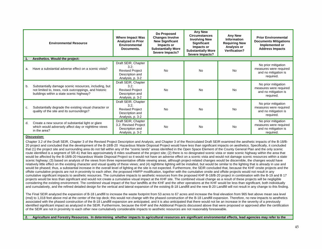
45
Environmental Resource
Where Impact Was Analyzed in Prior
Environmental Documents.
Do Proposed Changes Involve New Significant
Impacts or Substantially More Severe Impacts?
Any New Circumstances Involving New
Significant Impacts or
Substantially More Severe Impacts?
Any New Information
Requiring New Analysis or
Verification?
Prior Environmental Documents Mitigations
Implemented or Address Impacts
1. Aesthetics. Would the project:
a. Have a substantial adverse effect on a scenic vista?
Draft SEIR, Chapter 3.2;
Revised Project Description and Analysis, p. 3-2
No No No
No prior mitigation measures were required
and no mitigation is required.
b. Substantially damage scenic resources, including, but not limited to, trees, rock outcroppings, and historic buildings within a state scenic highway?
Draft SEIR, Chapter 3.2;
Revised Project Description and Analysis, p. 3-2
No No No
No prior mitigation measures were required
and no mitigation is required.
c. Substantially degrade the existing visual character or quality of the site and its surroundings?
Draft SEIR, Chapter 3.2;
Revised Project Description and Analysis, p. 3-2
No No No
No prior mitigation measures were required
and no mitigation is required.
d. Create a new source of substantial light or glare which would adversely affect day or nighttime views in the area?
Draft SEIR, Chapter 3.2; Revised Project
Description and Analysis, p. 3-2
No No No
No prior mitigation measures were required
and no mitigation is required.
Discussion:
Chapter 3.2 of the Draft SEIR, Chapter 3 of the Revised Project Description and Analysis, and Chapter 3 of the Recirculated Draft SEIR examined the aesthetic impacts of the B-18/B-20 project and concluded that the development of the B-18/B-20 Hazardous Waste Disposal Project would have less than significant impacts on aesthetics. Specifically, it concluded that (1) the project site and surrounding area do not fall within any of the “scenic lands” areas identified in the Open Space Element of the County General Plan and the only scenic route identified is a segment of SR-41 that lies approximately 8 miles southwest of the project site; (2) there is no designated scenic vista or state scenic highway within the area that would be affected by the B-18/B-20 Hazardous Waste Disposal Project so it would not have an adverse effect on a scenic vista and would not damage scenic resources within a state scenic highway; (3) based on analysis of the views from three representative offsite viewing areas, although project-related changes would be discernible, the changes would have relatively little effect on the existing character and visual quality of these views; and (4) nighttime lighting will be installed, but would be similar to the lighting that is already in use and would be phased; thus, a substantial increase in the overall level of lighting at the site is not expected. Furthermore, the SEIR concluded that, because the KHF onsite projects and the offsite cumulative projects are not in proximity to each other, the proposed HWFP modification, together with the cumulative onsite and offsite projects would not result in any cumulative significant impacts to aesthetic resources. The cumulative impacts to aesthetic resources from the proposed KHF B-18/B-20 project in combination with the B-19 and B 17 projects would be less than significant and would not create a cumulative visual impact at the KHF site. The combined visual change as a result of these projects will be negligible considering the existing environment. The combined visual impact of the four landfills at the KHF and the other operations at the KHF would be less than significant, both individually and cumulatively, and the refined detailed design for the vertical and lateral expansion of the existing B-18 Landfill and the new B-20 Landfill will not result in any change to this finding. The Final SEIR analyzed the expansion of B-18 Landfill to increase the waste footprint from 53 acres to 67 acres and increase the final elevation from 965 feet above mean sea level (msl) to 1,018 feet above msl at the center of the top deck; this would not change with the phased construction of the B-18 Landfill expansion. Therefore, no new impacts to aesthetics associated with the phased construction of the B-18 Landfill expansion are anticipated, and it is also anticipated that there would not be an increase in the severity of a previously identified significant impact as analyzed in the SEIR. Furthermore, because the KHF and the Additional Projects discussed above that were proposed or approved after the certification of the SEIR are not in proximity to each other new cumulatively considerable impacts to aesthetic resources are not reasonably foreseeable. 2. Agriculture and Forestry Resources. In determining whether impacts to agricultural resources are significant environmental effects, lead agencies may refer to the
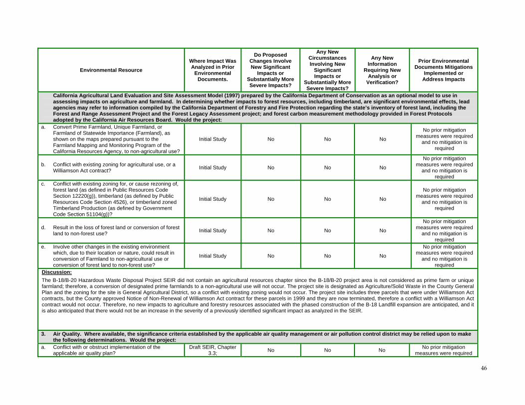
46
Environmental Resource
Where Impact Was Analyzed in Prior
Environmental Documents.
Do Proposed Changes Involve New Significant
Impacts or Substantially More Severe Impacts?
Any New Circumstances Involving New
Significant Impacts or
Substantially More Severe Impacts?
Any New Information
Requiring New Analysis or
Verification?
Prior Environmental Documents Mitigations
Implemented or Address Impacts
California Agricultural Land Evaluation and Site Assessment Model (1997) prepared by the California Department of Conservation as an optional model to use in assessing impacts on agriculture and farmland. In determining whether impacts to forest resources, including timberland, are significant environmental effects, lead agencies may refer to information compiled by the California Department of Forestry and Fire Protection regarding the state’s inventory of forest land, including the Forest and Range Assessment Project and the Forest Legacy Assessment project; and forest carbon measurement methodology provided in Forest Protocols adopted by the California Air Resources Board. Would the project:
a. Convert Prime Farmland, Unique Farmland, or Farmland of Statewide Importance (Farmland), as shown on the maps prepared pursuant to the Farmland Mapping and Monitoring Program of the California Resources Agency, to non-agricultural use?
Initial Study No No No
No prior mitigation measures were required
and no mitigation is required
b. Conflict with existing zoning for agricultural use, or a Williamson Act contract?
Initial Study No No No
No prior mitigation measures were required
and no mitigation is required
c. Conflict with existing zoning for, or cause rezoning of, forest land (as defined in Public Resources Code Section 12220(g)), timberland (as defined by Public Resources Code Section 4526), or timberland zoned Timberland Production (as defined by Government Code Section 51104(g))?
Initial Study No No No
No prior mitigation measures were required
and no mitigation is required
d. Result in the loss of forest land or conversion of forest land to non-forest use?
Initial Study No No No
No prior mitigation measures were required
and no mitigation is required
e. Involve other changes in the existing environment which, due to their location or nature, could result in conversion of Farmland to non-agricultural use or conversion of forest land to non-forest use?
Initial Study No No No
No prior mitigation measures were required
and no mitigation is required
Discussion:
The B-18/B-20 Hazardous Waste Disposal Project SEIR did not contain an agricultural resources chapter since the B-18/B-20 project area is not considered as prime farm or unique farmland; therefore, a conversion of designated prime farmlands to a non-agricultural use will not occur. The project site is designated as Agriculture/Solid Waste in the County General Plan and the zoning for the site is General Agricultural District, so a conflict with existing zoning would not occur. The project site includes three parcels that were under Williamson Act contracts, but the County approved Notice of Non-Renewal of Williamson Act contract for these parcels in 1999 and they are now terminated, therefore a conflict with a Williamson Act contract would not occur. Therefore, no new impacts to agriculture and forestry resources associated with the phased construction of the B-18 Landfill expansion are anticipated, and it is also anticipated that there would not be an increase in the severity of a previously identified significant impact as analyzed in the SEIR.
3. Air Quality. Where available, the significance criteria established by the applicable air quality management or air pollution control district may be relied upon to make the following determinations. Would the project:
a. Conflict with or obstruct implementation of the applicable air quality plan?
Draft SEIR, Chapter 3.3;
No No No No prior mitigation
measures were required
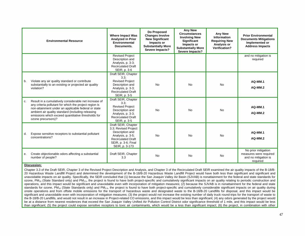
47
Environmental Resource
Where Impact Was Analyzed in Prior
Environmental Documents.
Do Proposed Changes Involve New Significant
Impacts or Substantially More Severe Impacts?
Any New Circumstances Involving New
Significant Impacts or
Substantially More Severe Impacts?
Any New Information
Requiring New Analysis or
Verification?
Prior Environmental Documents Mitigations
Implemented or Address Impacts
Revised Project Description and Analysis, p. 3-3;
Recirculated Draft SEIR, p. 3-6
and no mitigation is required
b. Violate any air quality standard or contribute substantially to an existing or projected air quality violation?
Draft SEIR, Chapter 3.3;
Revised Project Description and Analysis, p. 3-3;
Recirculated Draft SEIR, p. 3-5
No No No AQ-MM.1
AQ-MM.2
c. Result in a cumulatively considerable net increase of any criteria pollutant for which the project region is non-attainment under an applicable federal or state ambient air quality standard (including releasing emissions which exceed quantitative thresholds for ozone precursors)?
Draft SEIR, Chapter 3.3;
Revised Project Description and Analysis, p. 3-3;
Recirculated Draft SEIR, p. 3-5
No No No AQ-MM.1
AQ-MM.2
d. Expose sensitive receptors to substantial pollutant concentrations?
Draft SEIR, Chapter 3.3; Revised Project
Description and Analysis, p. 3-5;
Recirculated Draft SEIR, p. 3-6; Final
SEIR, p. 3-173
No No No AQ-MM.1
AQ-MM.2
e. Create objectionable odors affecting a substantial number of people?
Draft SEIR, Chapter 3.3
No No No
No prior mitigation measures were required
and no mitigation is required
Discussion:
Chapter 3.3 of the Draft SEIR, Chapter 3 of the Revised Project Description and Analysis, and Chapter 3 of the Recirculated Draft SEIR examined the air quality impacts of the B-18/B-20 Hazardous Waste Landfill Project and determined the development of the B-18/B-20 Hazardous Waste Landfill Project would have both less than significant and significant and unavoidable impacts on air quality. Specifically, the SEIR concluded that (1) because the San Joaquin Valley Air Basin (SJVAB) is nonattainment for the federal and state standards for ozone, PM10 (State Standard only) and PM2.5, the project is found to have both project-specific and cumulatively significant impacts on air quality relating to periodic construction and operations, and this impact would be significant and unavoidable even with incorporation of mitigation measures; (2) because the SJVAB is in nonattainment for the federal and state standards for ozone, PM10 (State Standards only) and PM2.5, the project is found to have both project-specific and cumulatively considerable significant impacts on air quality during onsite operations and from offsite mobile emissions for the transport of hazardous waste and designated waste to the B-18/B-20 Landfills for disposal, and this impact would be significant and unavoidable even with incorporation of mitigation measures; (3) the project would not increase the existing number of daily truck round-trips for the transport of waste to the B-18/B-20 Landfills, and would not result in an increase in Project-related CO emissions, and this impact would be less than significant; (4) any odors generated by the project would be at a distance from nearest residences that exceed the San Joaquin Valley Unified Air Pollution Control District odor significance threshold of 1 mile, and this impact would be less than significant; (5) the project could expose sensitive receptors to toxic air contaminants, which would be a less than significant impact; (6) the project, in combination with other
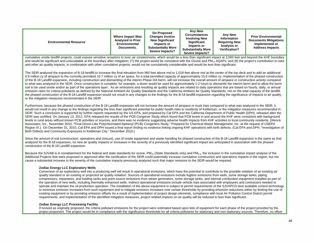
48
Environmental Resource
Where Impact Was Analyzed in Prior
Environmental Documents.
Do Proposed Changes Involve New Significant
Impacts or Substantially More Severe Impacts?
Any New Circumstances Involving New
Significant Impacts or
Substantially More Severe Impacts?
Any New Information
Requiring New Analysis or
Verification?
Prior Environmental Documents Mitigations
Implemented or Address Impacts
cumulative onsite landfill projects, could expose sensitive receptors to toxic air contaminants, which would be a less than significant impact at 2,000 feet and beyond the KHF boundary and would be significant and unavoidable at the boundary after mitigation; (7) the project would be consistent with the Ozone and PM10 AQAPs; and (8) the project’s contribution to odor and other air quality impacts, in combination with other cumulative projects, would not be cumulatively considerable and would be less than significant.
The SEIR analyzed the expansion of B-18 landfill to increase the final elevation from 965 feet above msl to 1,018 feet above msl at the center of the top deck and to add an additional 4.9 million cy of airspace to the currently permitted 10.7 million cy of air space, for a total permitted capacity of approximately 15.6 million cy. Implementation of the phased construction of the B-18 Landfill expansion, including construction and dismantling of the interim Phase IIIA berm, will not increase the overall amount of airspace or construction activity compared to what was analyzed in the SEIR. Once construction is complete, for example, a dozer would be used for approximately 1-2 hours to dismantle the interim berm and to allow the berm soil to be used onsite and/or as part of the operations layer. As air emissions and resulting air quality impacts are related to daily operations that are based on hourly, daily, or annual emission rates for criteria pollutants as defined by the National Ambient Air Quality Standards and the California Ambient Air Quality Standards, not on the total capacity of the landfill, the phased construction of the B-18 Landfill expansion would not result in any changes to the findings for the B-18 landfill expansion regarding the significance of impacts to air quality or the mitigation measures recommended in the SEIR. Furthermore, because the phased construction of the B-18 Landfill expansion will not increase the amount of airspace or truck trips compared to what was analyzed in the SEIR, it would not result in any change to the findings regarding the less than significant potential for public health risks to residents of Kettleman, or the mitigation measures recommended in SEIR. Such a conclusion is supported by further reports requested by the US EPA, and prepared by Cal EPA and the California Department of Public Health (DPH), released after the SEIR was certified. On January 13, 2011, EPA released the results of the PCB Congener Study which found that PCB levels in and around the KHF were consistent with background levels in rural areas without known PCB activities or sources, and there was no evidence suggesting adverse health impacts from KHF activities to local community residents. (Wenck Associates, Inc., November 2010, “Final Dioxin-Like Polychlorinated biphenyl (PCB) Congeners Study,” Prepared for Chemical Waste Management, Inc. at the request of USEPA Region IX.). On December 31, 2010, Cal EPA and DPH issued a final report finding no evidence linking ongoing KHF operations with birth defects. (Cal EPA and DPH, “Investigation of Birth Defects and Community Exposures in Kettleman City,” December 2010.) Since the amount of soil (construction, operations and closure), use of onsite equipment and waste handling for phased construction of the B-18 Landfill expansion is the same as that analyzed for the B-18 expansion, no new air quality impacts or increases in the severity of a previously identified significant impact are anticipated in association with the phased construction of the B-18 Landfill expansion. Because the SJVAB is in nonattainment for the federal and state standards for ozone, PM10 (State Standards only) and PM2.5, the inclusion in the cumulative impact analysis of the Additional Projects that were proposed or approved after the certification of the SEIR could potentially increase cumulative construction and operations impacts in the region, but not cause a substantial increase in the severity of the cumulative impacts previously analyzed such that major revisions to the SEIR would be required:
Zodiac Energy LLC Exploratory Wells Conversion of an exploratory well into a producing well will result in operational emissions, which have the potential to contribute to the possible violation of an existing air quality standard or an existing or projected air quality violation. Sources of operational emissions include fugitive emissions from wells, some storage tanks, piping, compressors, separators, and loading racks and point source emissions from steam generators, some storage tanks, and internal combustion equipment installed as part of the operation of new wells, including thermally enhanced wells. Indirect operational emissions include vehicle trips associated with employees and contractors needed to operate and maintain the oil production operation. The installation of the above equipment is subject to permit requirements of the SJVAPCD best available control technology to minimize emission increases from such equipment and to mitigate emission increases over certain thresholds by providing emission reductions either by limiting the use of existing equipment or by providing emission offsets As a result of implementation of project design elements, compliance with local Air Pollution Control District permit requirements, and implementation of the identified mitigation measures, project related impacts on air quality will be reduced to less than significant. Zodiac Energy LLC Processing Facility If revived as originally proposed, the criteria pollutant emissions for the project were estimated based upon lists of equipment for each phase of the project provided by the project proponent. The project would be in compliance with the significance thresholds for all criteria pollutants for stationary and non-stationary sources. Therefore, no offset
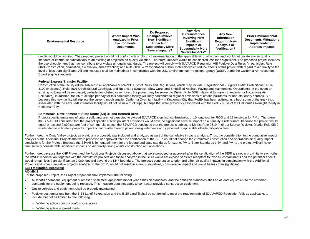
49
Environmental Resource
Where Impact Was Analyzed in Prior
Environmental Documents.
Do Proposed Changes Involve New Significant
Impacts or Substantially More Severe Impacts?
Any New Circumstances Involving New
Significant Impacts or
Substantially More Severe Impacts?
Any New Information
Requiring New Analysis or
Verification?
Prior Environmental Documents Mitigations
Implemented or Address Impacts
credits would be required. The proposed project would not conflict with or obstruct implementation of the applicable air quality plan, and would not violate any air quality standard or contribute substantially to an existing or projected air quality violation. Therefore, impacts would be considered less than significant. The proposed project includes the use of equipment that may contribute to or violate air quality standards. The project will comply with SJVAPCD Regulation VIII Fugitive Dust Rules (in particular, Rule 8021-Construction, demolition, excavation, and extraction) and Rule 8031, – transportation of bulk materials which reduce effects of this project with regard to air quality to the level of less than significant. All engines used shall be maintained in compliance with the U.S. Environmental Protection Agency (USEPA) and the California Air Resources Board engine standards. Federal Express Transfer Facility Construction of the facility will be subject to all applicable SJVAPCD District Rules and Regulations, which may include: Regulation VlIl (Fugitive PMIO Prohibitions), Rule 4102 (Nuisance), Rule 4601 (Architectural Coatings), and Rule 4641 (Cutback, Slow Cure, and Emulsified Asphalt, Paving and Maintenance Operations). In the event an existing building will be renovated, partially demolished or removed, the project may be subject to District Rule 4002 (National Emission Standards for Hazardous Air Pollutants). In addition, the 85 truck trips per day for this completed facility will likely contribute to regional emissions of criteria pollutants for non-stationary sources. But, because this new facility will replace the current, much smaller California Overnight facility in Kettleman City that FedEx has been utilizing as a hub, some of the truck trips associated with the new FedEx transfer facility would not be new truck trips, but trips that were previously associated with the FedEx’s use of the California Overnight facility in Kettleman City.
Commercial Development at State Route (SR)-41 and Bernard Drive Project specific emissions of criteria pollutants are not expected to exceed SJVAPCD significance thresholds of 10 tons/year for ROG and 15 tons/year for PM10. Therefore, the SJVAPCD concluded that the project specific criteria pollutant emissions would have no significant adverse impact on air quality. Furthermore, because the project would equal or exceed 2,000 square feet of commercial space, the SJVAPCD concluded that the project is subject to District Rule 9510 (Indirect Source Review). District Rule 9510 is intended to mitigate a project’s impact on air quality through project design elements or by payment of applicable off-site mitigation fees.
Furthermore, the Quay Valley project, as previously proposed, was included and analyzed as part of the cumulative impacts analysis. Thus, the consideration in the cumulative impact analysis of the Additional Projects that were proposed or approved after the certification of the SEIR would not change the cumulative construction and operations air quality impact conclusions for the Project. Because the SJVAB is in nonattainment for the federal and state standards for ozone, PM10 (State Standards only) and PM2.5, the project will still have cumulatively considerable significant impacts on air quality during onsite construction and operations. Furthermore, because the KHF Project and the Additional Projects discussed above that were proposed or approved after the certification of the SEIR are not in proximity to each other, the HWFP modification, together with the cumulative projects and those analyzed in the SEIR would not expose sensitive receptors to toxic air contaminants and the potential effects would remain less than significant at 2,000 feet and beyond the KHF boundary. The project’s contribution to odor and other air quality impacts, in combination with the Additional Projects and other cumulative projects analyzed in the SEIR, would not result in a new cumulatively considerable impact and would be less than significant. SEIR Mitigation Measures: AQ-MM.1 For the proposed Project, the Project proponent shall implement the following:
All landfill operational equipment purchased shall meet applicable model year emission standards, and the emission standards shall be at least equivalent to the emission standards for the equipment being replaced. This measure does not apply to contractor provided construction equipment.
Onsite vehicles and equipment shall be properly maintained.
Fugitive dust emissions from the B-18 Landfill expansion and the B-20 Landfill shall be controlled to meet the requirements of SJVUAPCD Regulation VIII, as applicable, to include, but not be limited to, the following:
Watering active construction/disposal areas
Watering active unpaved roads
50
Environmental Resource
Where Impact Was Analyzed in Prior
Environmental Documents.
Do Proposed Changes Involve New Significant
Impacts or Substantially More Severe Impacts?
Any New Circumstances Involving New
Significant Impacts or
Substantially More Severe Impacts?
Any New Information
Requiring New Analysis or
Verification?
Prior Environmental Documents Mitigations
Implemented or Address Impacts
Watering of daily cover stockpiles and the unpaved roads used to access the daily cover stockpiles
Track-out controls would be installed at the transition of dirt roads to paved roads that provide access to B-18 and B-20 landfills Vehicles and equipment shall be restricted to specific onsite roads.
Vehicle speed on onsite roads to/from the landfill shall be limited to 15 miles per hour on paved and unpaved roads.
AQ-MM.2 For the purchase of primary heavy duty, diesel powered landfill equipment (dozer) at the B-18 Landfill expansion and the B-20 Landfill, if equipment meeting Tier 4 emission standards for off-highway, heavy duty diesel equipment is commercially available prior to 2014, CWMI shall purchase such equipment. Alternatively, rather than purchase new equipment, CWMI may: retrofit its existing primary heavy duty, diesel powered landfill equipment (dozer) at the B-18 Landfill, implement the use of low emission diesel products, alternative fuels, advanced exhaust gas after-treatment products and/or implement other options, or combinations thereof, as they become available to achieve early compliance. In the event equipment meeting Tier 4 emission standards for off-highway, heavy duty diesel equipment or a retrofit kit are not commercially available prior to 2014, CWMI shall purchase such equipment or retrofit kit once they become commercially available in California (Draft SEIR, pp. 3.3-16 to 3.3-18; Final SEIR, p. 2-8). 4. Biological Resources. Would the project:
a. Have a substantial adverse effect, either directly or through habitat modifications, on any species identified as a candidate, sensitive, or special status species in local or regional plans, policies, or regulations, or by the California Department of Fish and Game or U.S. Fish and Wildlife Service?
Draft SEIR, Chapter 3.4;
Revised Project Description and Analysis, p. 3-6.
No No No
BR-MM.1 BR-MM.2 BR-MM.3 BR-MM.4 BR-MM.5 BR-MM.6 BR-MM.7 BR-MM.8 BR-MM.9
BR-MM.10 BR-MM.11 BR-MM.12
b. Have a substantial adverse effect on any riparian habitat or other sensitive natural community identified in local or regional plans, policies, or regulations or by the California Department of Fish and Game or US Fish and Wildlife Service?
Initial Study Draft SEIR, Chapter
3.4 No No No
No prior mitigation measures were required
and no mitigation is required
c. Have a substantial adverse effect on federally protected wetlands as defined by Section 404 of the Clean Water Act (including, but not limited to, marsh, vernal pool, coastal, etc.) through direct removal, filling, hydrological interruption, or other means?
Initial Study Draft SEIR, Chapter
3.4 No No No
No prior mitigation measures were required
and no mitigation is required
d. Interfere substantially with the movement of any native resident or migratory fish and wildlife species or with established native resident or migratory wildlife corridors, or impede the use of native wildlife
Initial Study Draft SEIR, Chapter
3.4 No No No
No prior mitigation measures were required
and no mitigation is required

51
Environmental Resource
Where Impact Was Analyzed in Prior
Environmental Documents.
Do Proposed Changes Involve New Significant
Impacts or Substantially More Severe Impacts?
Any New Circumstances Involving New
Significant Impacts or
Substantially More Severe Impacts?
Any New Information
Requiring New Analysis or
Verification?
Prior Environmental Documents Mitigations
Implemented or Address Impacts
nursery sites?
e. Conflict with any local policies or ordinances protecting biological resources, such as a tree preservation policy or ordinance?
Initial Study Draft SEIR, Chapter
3.4 No No No
No prior mitigation measures were required
and no mitigation is required
f. Conflict with the provisions of an adopted Habitat Conservation Plan, Natural Community Conservation Plan, or other approved local, regional, or state habitat conservation plan?
Initial Study Draft SEIR, Chapter
3.4 No No No
No prior mitigation measures were required
and no mitigation is required
Discussion:
As determined in the Initial Study prepared for the B-18/B-20 Hazardous Waste Landfill Project, the project would not result in impacts to wetlands, local policies or ordinances protecting biological resources, or a Habitat Conservation Plan or other adopted conservation plans. Chapter 3.4 of the Draft SEIR and Chapter 3 of the Revised Project Description and Analysis examined the biological resources impacts of the B-18/B-20 Hazardous Waste Landfill Project and acknowledged that the development of the B-18/B-20 Hazardous Waste Landfill Project would have less than significant impacts on biological resources. Specifically, it concluded that (1) based on special status surveys of the Project areas in 2002 and 2004, and as updated in 2012, and including surveys for special-status plant species such as the California jewelflower and San Joaquin woolly threads, which have a low potential for occurrence, the potential adverse effects to listed plant species was found to be less than significant; (2) the project could result in potential for significant direct and indirect effects to the San Joaquin kit fox which would be a less than significant impact with mitigation measures; (3) the project may degrade suitable blunt-nosed leopard lizard habitat which would be a less than significant impact with mitigation measures; (4) the project could disturb loggerhead shrike nesting/breeding habitat, which would be a less than significant impact with mitigation measures; (5) the project would result in the potential for direct and indirect effects to the badger from general human activities at KHF associated with the periodic construction and long-term operation of the B-18 and B-20 landfills which would be a less than significant impact with mitigation measures; and (6) the project would result in a cumulatively considerable contribution to impacts to biological resources that would be reduced to a less than significant level with mitigation measures.
The SEIR analyzed the expansion of B-18 Landfill to increase the waste footprint from 53 acres to 67 acres; this would not change with the phased construction of the B-18 Landfill expansion. Therefore, no new impacts to biological resources associated with the phased construction of the B-18 Landfill expansion are anticipated. There would also not be an increase in the severity of a previously identified significant impact as analyzed in the SEIR.
The inclusion in the cumulative impact analysis of the Additional Projects that were proposed or approved after the certification of the SEIR could potentially contribute to the cumulative biological resources impacts but would not require major revisions to the SEIR due to any new significant adverse impacts or substantial increase in severity of a previously identified significant impact of the KHF Project:
Zodiac Energy LLC Exploratory Wells Agricultural lands within the project site and area are plowed and planted to barley, wheat, and other grain crops once every two (2) to three (3) years. These grain crops are either harvested or left in the fields and not harvested. These fields are grazed by cattle after they grow and prior to the next plowing/planting cycle. As these areas have been farmed for many years, and agricultural activities have likely extirpated special-status wildlife species from the project area. Therefore, it was determined that the project site and buffer areas as were not suitable habitat for special status mammal or avian species. Based on the environmental conditions and habitats present within areas proposed for disturbance or use during project implementation, the habitat requirements of special-status plant species identified within the general area of the project site, and based on botanical surveys conducted, no sensitive plant species have the potential to occur in the proposed well sites or existing access roads. Therefore, special-status plant species are assumed to be absent from the proposed well sites and existing access roads, and no impacts to special-status plant species are expected during project implementation. Zodiac Energy LLC Processing Facility (on hold)
52
Environmental Resource
Where Impact Was Analyzed in Prior
Environmental Documents.
Do Proposed Changes Involve New Significant
Impacts or Substantially More Severe Impacts?
Any New Circumstances Involving New
Significant Impacts or
Substantially More Severe Impacts?
Any New Information
Requiring New Analysis or
Verification?
Prior Environmental Documents Mitigations
Implemented or Address Impacts
A Biological Assessment Report for the project determined that no special status plant species were positively identified during the site visits to the proposed project site. At the time of the surveys, the project site and surrounding areas were vegetated with wheat, pistachio trees, or ruderal/disturbed vegetation. These areas have been in agricultural production for many years, and agricultural activities have likely extirpated special-status plant species from the project site. Based on the environmental conditions and habitats present within areas proposed for disturbance or use during project implementation, the habitat requirements of special-status plant species identified within the general area of the project site, and based on botanical surveys conducted, no sensitive plant species have the potential to occur in areas proposed for ground disturbance. No potential habitat for round-leaved filaree, crownscale, Lost Hills crownscale, California jewelflower (low), slough thistle, recurved larkspur, San Joaquin woollythreads (low), mud nama and Kings gold was observed within the project site or buffer areas during biological surveys. Therefore, special-status plant species were assumed to be absent from the project site in the SEIR, as confirmed in 2012. (McCormick.) Thus, no significant adverse impacts to special-status plant species are expected during project implementation. The Biological Assessment Report also determined that no special status animal species were positively identified during the site visits to the proposed project site. No potential habitat for the Nelson’s antelope squirrel, giant kangaroo rat, Tipton kangaroo rat, Tulare grasshopper mouse, American badger, San Joaquin kit fox, tricolored black bird, burrowing owl, western snowy plover, loggerhead shrike, vernal pool fairy shrimp, valley elderberry longhorn beetle, California tiger salamander, blunt-nosed leopard lizard, San Joaquin whipsnake, California red-legged frog and giant garter snake was observed within the project site or buffer areas during biological surveys. As the project site and buffer areas are currently utilized for growing agricultural crops (grains and pistachios), these species are unlikely to be present. However, the Avoidance and Minimization Measures Section of the Biological Assessment Report recommends mitigation measure to reduce impacts to Special Status Animal and Plant Species to a level that is less than significant. Federal Express Transfer Facility Biological Resources Study was prepared for this project and found that the project site contains no suitable habitat for any sensitive plant species, therefore no focused surveys area required. Due to the disturbed nature of the project site, it is highly unlikely that any sensitive plant species occurs on site. Project related impacts will not have a significant effect with regard to sensitive plants and no further actions are required. The Biological Resources Study also found that the project site contains marginal quality habitat for 12 sensitive wildlife species, five of which are federally or state listed as threatened or endangered. Based on the current project site conditions, project related impacts to blunt-nosed leopard lizard and San Joaquin kit fox may be considered significant if present on site, but avoidance and minimization measures are recommended and are listed as requirements of approval of the project. Commercial Development at State Route (SR)-41 and Bernard Drive A Reconnaissance Biological Survey Report (RBSR) was prepared for the proposed project and was circulated on November 22, 2010. The RBSR found that “[s]oil conditions and a general proximity to other recorded occurrences supporting sensitive plant and animal species indicate the possibility that the project area may have historically supported some sensitive plant and animal species and biological resources. The long-term agricultural and commercial usages, and the current habitat conditions, generally preclude the occurrence of sensitive species at the described site. This analysis is consistent with the earlier biological studies performed by the County in the general area.”
Thus, HWFP modification, in combination with Additional Projects and other cumulative projects analyzed in the SEIR, could potentially contribute cumulatively to the loss of potential habitat in Kings County and/or cause disturbance to special-status species, but since such impacts would be mitigated, would not result in an increase in the severity of previously identified cumulatively significant impacts. Moreover, since the KHF Project can be mitigated to below a level of significance through the implement of mitigation measures BR-MM.1 through BR.MM.12, there would be no increase in the severity of previously identified cumulatively considerable impacts to biological resources analyzed in the SEIR.
SEIR Mitigation Measures:
BR-MM.1
The following shall be implemented as general mitigation measures to reduce impacts to wildlife species and habitat:
To minimize disturbance to wildlife, lighting at the landfill working faces shall be downcast and shielded to minimize reflection, and shall be directed inward toward the landfill. Night
53
Environmental Resource
Where Impact Was Analyzed in Prior
Environmental Documents.
Do Proposed Changes Involve New Significant
Impacts or Substantially More Severe Impacts?
Any New Circumstances Involving New
Significant Impacts or
Substantially More Severe Impacts?
Any New Information
Requiring New Analysis or
Verification?
Prior Environmental Documents Mitigations
Implemented or Address Impacts
lighting used on the landfills shall be of a low-intensity, low-glare design.
No firearms shall be allowed on the Project site, except in the possession of authorized personnel (e.g., sheriff, County agricultural commissioner, and other law enforcement personnel).
Upon completion of the Project, areas subject to temporary ground disturbance, including storage and staging areas, temporary roads, pipeline corridors, etc., shall be recontoured and revegetated, if necessary, to promote restoration of the area to pre-Project conditions. An area subject to "temporary" disturbance means any area that is disturbed during the Project, but would not be subject to further disturbance after Project completion and has the potential to be revegetated. Appropriate methods and plant species used to revegetate such areas shall be determined in consultation with the USFWS and CDFG.
Employees and construction supervising personnel shall be required to attend a Listed Species Education Program. These personnel shall participate in the program prior to initiation of construction activity, and new employees shall receive the training prior to working on the active site. At a minimum, the program shall cover the general behavior and ecology of the pertinent listed species, legal protection, penalties for state and federal law violations, and protective measures. Construction supervisors shall train their respective personnel in this program. A fact sheet conveying this information shall be made available to onsite personnel, construction workers, and anyone else who may enter the disposal site.
Permanent and temporary construction disturbances and other types of Project-related disturbance to habitat lands shall be minimized to the extent feasible. To minimize temporary disturbances, Project-related vehicle traffic shall be restricted to established roads, construction areas, and other designated onsite roads. These areas shall also be included in pre-construction surveys and, to the extent practicable, shall be established in locations disturbed by previous activities to prevent further impacts.
CWMI employees and construction workers shall be instructed to dispose of food-related trash in closed containers or remove the trash from the Project area.
Vehicles in active site areas shall observe a 15-mph speed limit except on County roads and state and federal highways; this is particularly important at night when San Joaquin kit foxes are most active. To the extent practicable, nighttime construction shall be minimized.
To prevent harassment or mortality of San Joaquin kit fox, or destruction of dens by dogs or cats, no pets shall be permitted on the active areas of KHF. Pets or guide dogs brought to the administrative areas of the site shall be restrained on a leash or otherwise confined.
BR-MM.2
Prior to the commencement of construction activities for the expansion of the B-18 Landfill outside of the existing 474-acre operational area, the Project Proponent shall dedicate in perpetuity land that the USFWS and CDFG agree is of similar type and habitat value as that affected by the Project, to a non-profit conservation or federal, state or local government conservation management entity, or purchase habitat credits in an approved offsite land mitigation bank, or a combination of dedication and purchase of habitat credit to compensate for the direct and indirect effects of the Project to suitable habitat for the rare, threatened and endangered wildlife species, including the San Joaquin kit fox. The land may be dedicated in fee or as part of a perpetual conservation easement. The amount of land dedicated or habitat credit purchased will be at a ratio of 3:1 (3 acres of dedicated land for each 1 acre of habitat loss) for permanent disturbance and 1.1:1 for area subject to temporary disturbance, or at a compensation ratio agreed upon by the USFWS and CDFG.
As part of the TSCA permitting process, the US EPA will consult with the USFWS regarding impacts to the San Joaquin kit fox, as required under Section 7 of the federal Endangered Species Act, and will obtain, prior to issuing the TSCA permit, a biological option with an incidental take permit. The Project Proponent shall comply with such terms and conditions outlined in the biological opinion and shall provide the County with proof that the conditions have been satisfied.
BR-MM.3
The Project proponent shall appoint a representative who will be the onsite contact person for any landfill employee or contractor who might inadvertently kill or injure a San Joaquin kit fox, or who finds a dead, injured, or entrapped animal. The representative will be identified during the education program for employees and construction supervising personnel. The representative's name and telephone number shall be provided to the USFWS and CDFG.
BR-MM.4
Any planned Project disturbance in areas outside the existing 474-acre operational area shall be subject to a pre-construction survey. The survey, conducted by a Qualified Biologist, shall occur no more than 30 days prior to the beginning of ground disturbance and/or construction activities. A record of such construction or disturbance events, and the results of the pre-construction surveys, shall be submitted to the USFWS, CDFG, and Kings County annually, or at other frequency approved by the two wildlife agencies. Methods employed during these
54
Environmental Resource
Where Impact Was Analyzed in Prior
Environmental Documents.
Do Proposed Changes Involve New Significant
Impacts or Substantially More Severe Impacts?
Any New Circumstances Involving New
Significant Impacts or
Substantially More Severe Impacts?
Any New Information
Requiring New Analysis or
Verification?
Prior Environmental Documents Mitigations
Implemented or Address Impacts
surveys shall follow the USFWS and CDFG approved techniques:
Surveys shall evaluate use by kit fox and, if possible, assess potential impacts to the kit fox by the proposed activity. The status of active/inactive dens shall be determined and recorded.
For the purpose of these mitigation measures, a “Trained Biologist” is a person who is either a direct employee of the project proponent or a person retained by the project proponent who is very familiar with the wildlife in the area and who has been trained by a Qualified Biologist. CWMI shall submit the names, credentials and contact information of the Qualified Biologist that will conduct preconstruction protocol surveys and/or construction monitoring to the USFWS and CDFG. A Trained Biologist may conduct future routine surveys, monitoring and reporting consistent with the final biological analysis completed for the Project under Section 7.
BR-MM.5
Limited destruction of unoccupied San Joaquin kit fox dens and potential kit fox dens may be allowed if avoidance is infeasible provided the following procedures are observed:
A Trained Biologist shall monitor the den for a minimum of three (3) days prior to disturbance to determine if the den is actually being used by kit fox. After the first three (3) days of monitoring, the den shall be partially filled a minimum of three (3) additional days to allow the animal to move to another den during its normal activities.
After the den is determined to be unoccupied (i.e., no kit fox are inside), it can be destroyed by careful excavation. The den shall be fully excavated, filled with dirt, and compacted to ensure that San Joaquin kit fox cannot use the den during the construction period. USFWS and CDFG encourage hand excavation, but realize that soil conditions may necessitate the use of excavating equipment. Excavation and compaction efforts shall be conducted or overseen by a Trained Biologist.
If, at any point, a kit fox is thought to be using the den, the plugging or excavation activity shall stop and USFWS and CDFG shall be contacted immediately.
Natal or pupping dens that are occupied shall not be destroyed until the pups and adults have vacated, and then only after consultation with the USFWS and CDFG. Therefore, Project activities at some den sites shall be postponed if the dens are occupied.
If excavation of a den thought to be active (but not a natal or pupping den) is unavoidable, the Qualified Biologist shall notify USFWS and CDFG in writing, before plugging or excavation activities may begin, of the intent to destroy subject dens and of the reasons why alternative courses of action are not possible. If given permission by these agencies, excavation plans may proceed as outlined below under the direction and supervision of the Qualified Biologist. If the animal does not change dens, excavation of the den may have to occur when it is temporarily vacant (e.g., at night). Plugging and excavation activities shall be avoided to the extent feasible during the breeding season (January 15 through June 1), when most active dens are being used as reproductive or pupping dens.
The den shall be monitored for at least five (5) consecutive days in addition to the three (3) initial observation times. This time period will allow any resident animal to move to another den during its normal activity. This monitoring shall be conducted by a Trained Biologist.
Use of the den can be discouraged during this five-day period by partially plugging its entrance(s) with soil in such a manner that any resident animal can escape easily. This monitoring and plugging shall be conducted by a Trained Biologist.
When signs of activity at the den cease and the USFWS and CDFG (or a Qualified Biologist) deem it safe to do so, the den can be dug out by hand tools to a point where it is certain no kit fox is using the den. The den shall be fully excavated and then filled with dirt and compacted to ensure that the kit fox cannot reenter the den during the construction period. USFWS and CDFG encourage hand excavation, but realize that soil conditions may necessitate the use of excavating equipment. This den destruction shall be conducted or overseen by a Trained Biologist. CWMI shall submit the names, credentials and contact information of the Qualified Biologist that will conduct preconstruction protocol surveys and/or construction monitoring to the USFSW and CDFG. A Trained Biologist may conduct future routine surveys, monitoring and reporting consistent with the final biological analysis completed for the Project under Section 7.
A Trained Biologist shall document and report den monitoring and plugging activities in writing to USFWS, CDFG, and Kings County annually, or at other frequency approved by the two wildlife agencies.
If a take authorization/permit has been obtained from the USFWS and CDFG, active den destruction may proceed consistent with the terms of the incidental take permit. If no take authorization/permit has been issued, then potential dens shall be monitored in accordance with the procedures included this mitigation measure.
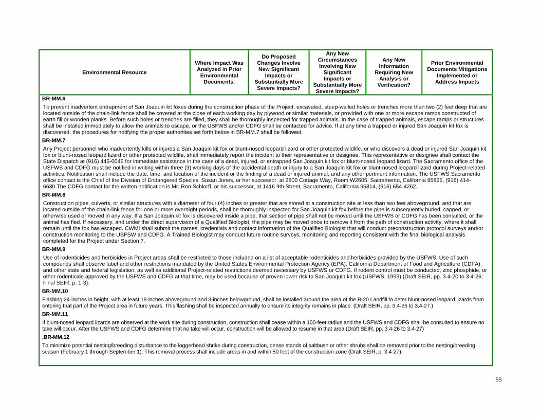
55
Environmental Resource
Where Impact Was Analyzed in Prior
Environmental Documents.
Do Proposed Changes Involve New Significant
Impacts or Substantially More Severe Impacts?
Any New Circumstances Involving New
Significant Impacts or
Substantially More Severe Impacts?
Any New Information
Requiring New Analysis or
Verification?
Prior Environmental Documents Mitigations
Implemented or Address Impacts
BR-MM.6
To prevent inadvertent entrapment of San Joaquin kit foxes during the construction phase of the Project, excavated, steep-walled holes or trenches more than two (2) feet deep that are located outside of the chain-link fence shall be covered at the close of each working day by plywood or similar materials, or provided with one or more escape ramps constructed of earth fill or wooden planks. Before such holes or trenches are filled, they shall be thoroughly inspected for trapped animals. In the case of trapped animals, escape ramps or structures shall be installed immediately to allow the animals to escape, or the USFWS and/or CDFG shall be contacted for advice. If at any time a trapped or injured San Joaquin kit fox is discovered, the procedures for notifying the proper authorities set forth below in BR-MM.7 shall be followed.
BR-MM.7
Any Project personnel who inadvertently kills or injures a San Joaquin kit fox or blunt-nosed leopard lizard or other protected wildlife, or who discovers a dead or injured San Joaquin kit fox or blunt-nosed leopard lizard or other protected wildlife, shall immediately report the incident to their representative or designee. This representative or designee shall contact the State Dispatch at (916) 445-0045 for immediate assistance in the case of a dead, injured, or entrapped San Joaquin kit fox or blunt-nosed leopard lizard. The Sacramento office of the USFWS and CDFG must be notified in writing within three (3) working days of the accidental death or injury to a San Joaquin kit fox or blunt-nosed leopard lizard during Project-related activities. Notification shall include the date, time, and location of the incident or the finding of a dead or injured animal, and any other pertinent information. The USFWS Sacramento office contact is the Chief of the Division of Endangered Species, Susan Jones, or her successor, at 2800 Cottage Way, Room W2605, Sacramento, California 95825, (916) 414-6630.The CDFG contact for the written notification is Mr. Ron Schlorff, or his successor, at 1416 9th Street, Sacramento, California 95814, (916) 654-4262.
BR-MM.8
Construction pipes, culverts, or similar structures with a diameter of four (4) inches or greater that are stored at a construction site at less than two feet aboveground, and that are located outside of the chain-link fence for one or more overnight periods, shall be thoroughly inspected for San Joaquin kit fox before the pipe is subsequently buried, capped, or otherwise used or moved in any way. If a San Joaquin kit fox is discovered inside a pipe, that section of pipe shall not be moved until the USFWS or CDFG has been consulted, or the animal has fled. If necessary, and under the direct supervision of a Qualified Biologist, the pipe may be moved once to remove it from the path of construction activity, where it shall remain until the fox has escaped. CWMI shall submit the names, credentials and contact information of the Qualified Biologist that will conduct preconstruction protocol surveys and/or construction monitoring to the USFSW and CDFG. A Trained Biologist may conduct future routine surveys, monitoring and reporting consistent with the final biological analysis completed for the Project under Section 7.
BR-MM.9
Use of rodenticides and herbicides in Project areas shall be restricted to those included on a list of acceptable rodenticides and herbicides provided by the USFWS. Use of such compounds shall observe label and other restrictions mandated by the United States Environmental Protection Agency (EPA), California Department of Food and Agriculture (CDFA), and other state and federal legislation, as well as additional Project-related restrictions deemed necessary by USFWS or CDFG. If rodent control must be conducted, zinc phosphide, or other rodenticide approved by the USFWS and CDFG at that time, may be used because of proven lower risk to San Joaquin kit fox (USFWS, 1999) (Draft SEIR, pp. 3.4-20 to 3.4-26; Final SEIR, p. 1-3).
BR-MM.10
Flashing 24-inches in height, with at least 18-inches aboveground and 3-inches belowground, shall be installed around the area of the B-20 Landfill to deter blunt-nosed leopard lizards from entering that part of the Project area in future years. This flashing shall be inspected annually to ensure its integrity remains in place. (Draft SEIR, pp. 3.4-26 to 3.4-27.)
BR-MM.11
If blunt-nosed leopard lizards are observed at the work site during construction, construction shall cease within a 100-feet radius and the USFWS and CDFG shall be consulted to ensure no take will occur. After the USFWS and CDFG determine that no take will occur, construction will be allowed to resume in that area (Draft SEIR, pp. 3.4-26 to 3.4-27)
.BR-MM.12
To minimize potential nesting/breeding disturbance to the loggerhead shrike during construction, dense stands of saltbush or other shrubs shall be removed prior to the nesting/breeding season (February 1 through September 1). This removal process shall include areas in and within 50 feet of the construction zone (Draft SEIR, p. 3.4-27).
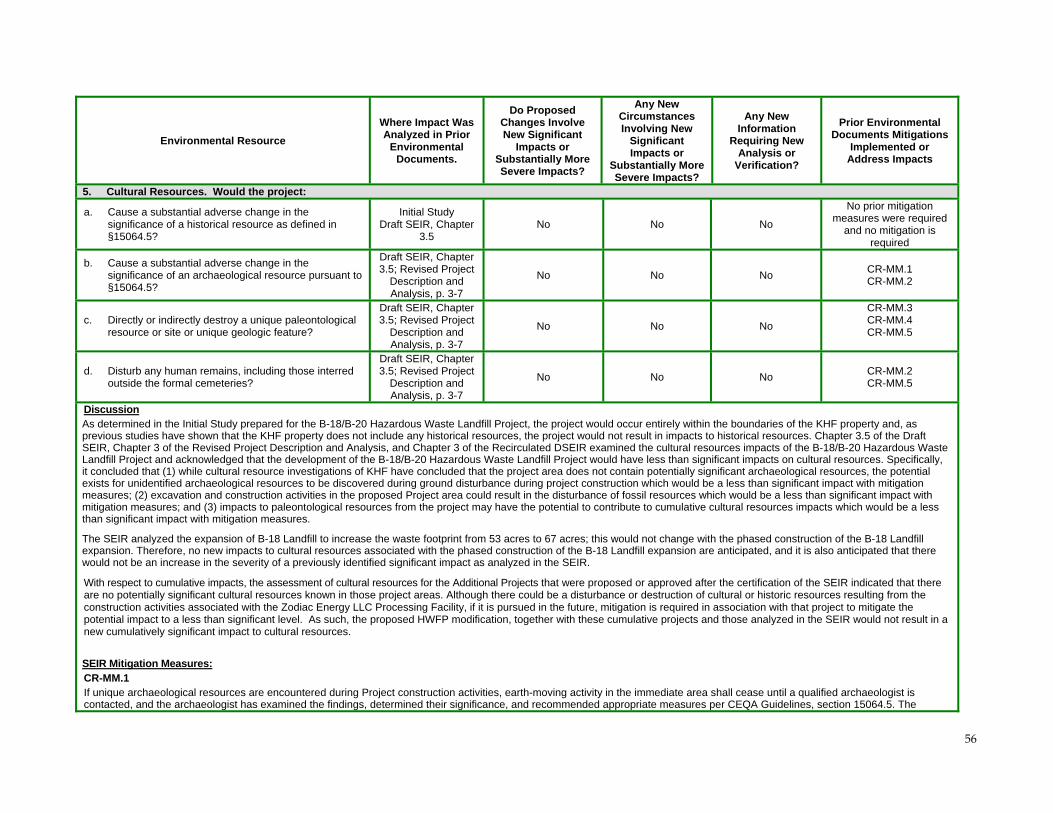
56
Environmental Resource
Where Impact Was Analyzed in Prior
Environmental Documents.
Do Proposed Changes Involve New Significant
Impacts or Substantially More Severe Impacts?
Any New Circumstances Involving New
Significant Impacts or
Substantially More Severe Impacts?
Any New Information
Requiring New Analysis or
Verification?
Prior Environmental Documents Mitigations
Implemented or Address Impacts
5. Cultural Resources. Would the project:
a. Cause a substantial adverse change in the significance of a historical resource as defined in §15064.5?
Initial Study Draft SEIR, Chapter
3.5 No No No
No prior mitigation measures were required
and no mitigation is required
b. Cause a substantial adverse change in the significance of an archaeological resource pursuant to §15064.5?
Draft SEIR, Chapter 3.5; Revised Project
Description and Analysis, p. 3-7
No No No CR-MM.1 CR-MM.2
c. Directly or indirectly destroy a unique paleontological resource or site or unique geologic feature?
Draft SEIR, Chapter 3.5; Revised Project
Description and Analysis, p. 3-7
No No No
CR-MM.3 CR-MM.4 CR-MM.5
d. Disturb any human remains, including those interred outside the formal cemeteries?
Draft SEIR, Chapter 3.5; Revised Project
Description and Analysis, p. 3-7
No No No CR-MM.2 CR-MM.5
Discussion As determined in the Initial Study prepared for the B-18/B-20 Hazardous Waste Landfill Project, the project would occur entirely within the boundaries of the KHF property and, as previous studies have shown that the KHF property does not include any historical resources, the project would not result in impacts to historical resources. Chapter 3.5 of the Draft SEIR, Chapter 3 of the Revised Project Description and Analysis, and Chapter 3 of the Recirculated DSEIR examined the cultural resources impacts of the B-18/B-20 Hazardous Waste Landfill Project and acknowledged that the development of the B-18/B-20 Hazardous Waste Landfill Project would have less than significant impacts on cultural resources. Specifically, it concluded that (1) while cultural resource investigations of KHF have concluded that the project area does not contain potentially significant archaeological resources, the potential exists for unidentified archaeological resources to be discovered during ground disturbance during project construction which would be a less than significant impact with mitigation measures; (2) excavation and construction activities in the proposed Project area could result in the disturbance of fossil resources which would be a less than significant impact with mitigation measures; and (3) impacts to paleontological resources from the project may have the potential to contribute to cumulative cultural resources impacts which would be a less than significant impact with mitigation measures.
The SEIR analyzed the expansion of B-18 Landfill to increase the waste footprint from 53 acres to 67 acres; this would not change with the phased construction of the B-18 Landfill expansion. Therefore, no new impacts to cultural resources associated with the phased construction of the B-18 Landfill expansion are anticipated, and it is also anticipated that there would not be an increase in the severity of a previously identified significant impact as analyzed in the SEIR.
With respect to cumulative impacts, the assessment of cultural resources for the Additional Projects that were proposed or approved after the certification of the SEIR indicated that there are no potentially significant cultural resources known in those project areas. Although there could be a disturbance or destruction of cultural or historic resources resulting from the construction activities associated with the Zodiac Energy LLC Processing Facility, if it is pursued in the future, mitigation is required in association with that project to mitigate the potential impact to a less than significant level. As such, the proposed HWFP modification, together with these cumulative projects and those analyzed in the SEIR would not result in a new cumulatively significant impact to cultural resources.
SEIR Mitigation Measures: CR-MM.1 If unique archaeological resources are encountered during Project construction activities, earth-moving activity in the immediate area shall cease until a qualified archaeologist is contacted, and the archaeologist has examined the findings, determined their significance, and recommended appropriate measures per CEQA Guidelines, section 15064.5. The
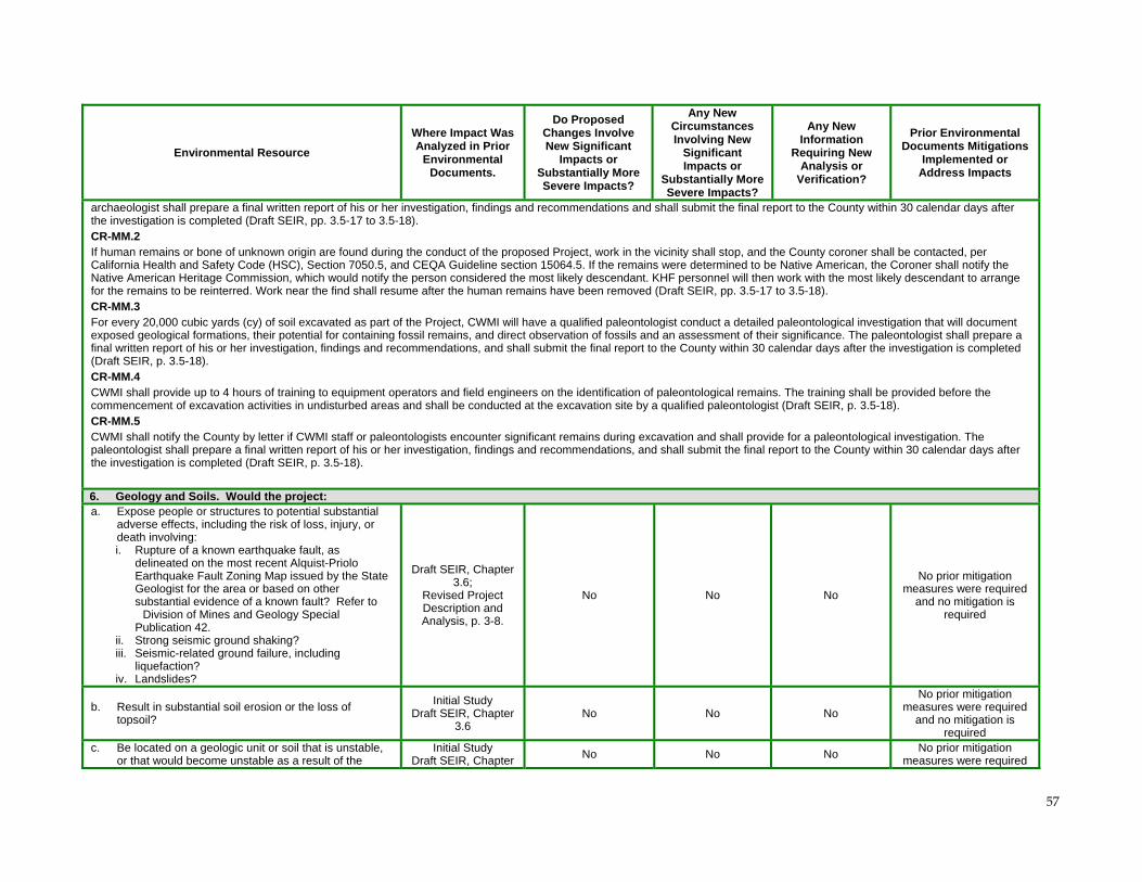
57
Environmental Resource
Where Impact Was Analyzed in Prior
Environmental Documents.
Do Proposed Changes Involve New Significant
Impacts or Substantially More Severe Impacts?
Any New Circumstances Involving New
Significant Impacts or
Substantially More Severe Impacts?
Any New Information
Requiring New Analysis or
Verification?
Prior Environmental Documents Mitigations
Implemented or Address Impacts
archaeologist shall prepare a final written report of his or her investigation, findings and recommendations and shall submit the final report to the County within 30 calendar days after the investigation is completed (Draft SEIR, pp. 3.5-17 to 3.5-18). CR-MM.2 If human remains or bone of unknown origin are found during the conduct of the proposed Project, work in the vicinity shall stop, and the County coroner shall be contacted, per California Health and Safety Code (HSC), Section 7050.5, and CEQA Guideline section 15064.5. If the remains were determined to be Native American, the Coroner shall notify the Native American Heritage Commission, which would notify the person considered the most likely descendant. KHF personnel will then work with the most likely descendant to arrange for the remains to be reinterred. Work near the find shall resume after the human remains have been removed (Draft SEIR, pp. 3.5-17 to 3.5-18). CR-MM.3 For every 20,000 cubic yards (cy) of soil excavated as part of the Project, CWMI will have a qualified paleontologist conduct a detailed paleontological investigation that will document exposed geological formations, their potential for containing fossil remains, and direct observation of fossils and an assessment of their significance. The paleontologist shall prepare a final written report of his or her investigation, findings and recommendations, and shall submit the final report to the County within 30 calendar days after the investigation is completed (Draft SEIR, p. 3.5-18). CR-MM.4 CWMI shall provide up to 4 hours of training to equipment operators and field engineers on the identification of paleontological remains. The training shall be provided before the commencement of excavation activities in undisturbed areas and shall be conducted at the excavation site by a qualified paleontologist (Draft SEIR, p. 3.5-18). CR-MM.5 CWMI shall notify the County by letter if CWMI staff or paleontologists encounter significant remains during excavation and shall provide for a paleontological investigation. The paleontologist shall prepare a final written report of his or her investigation, findings and recommendations, and shall submit the final report to the County within 30 calendar days after the investigation is completed (Draft SEIR, p. 3.5-18).
6. Geology and Soils. Would the project: a. Expose people or structures to potential substantial
adverse effects, including the risk of loss, injury, or death involving: i. Rupture of a known earthquake fault, as
delineated on the most recent Alquist-Priolo Earthquake Fault Zoning Map issued by the State Geologist for the area or based on other substantial evidence of a known fault? Refer to Division of Mines and Geology Special Publication 42.
ii. Strong seismic ground shaking? iii. Seismic-related ground failure, including
liquefaction? iv. Landslides?
Draft SEIR, Chapter 3.6;
Revised Project Description and Analysis, p. 3-8.
No No No
No prior mitigation measures were required
and no mitigation is required
b. Result in substantial soil erosion or the loss of topsoil?
Initial Study Draft SEIR, Chapter
3.6 No No No
No prior mitigation measures were required
and no mitigation is required
c. Be located on a geologic unit or soil that is unstable, or that would become unstable as a result of the
Initial Study Draft SEIR, Chapter
No No No No prior mitigation measures were required
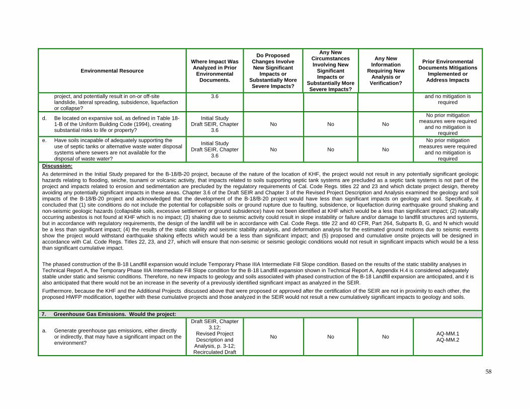
58
Environmental Resource
Where Impact Was Analyzed in Prior
Environmental Documents.
Do Proposed Changes Involve New Significant
Impacts or Substantially More Severe Impacts?
Any New Circumstances Involving New
Significant Impacts or
Substantially More Severe Impacts?
Any New Information
Requiring New Analysis or
Verification?
Prior Environmental Documents Mitigations
Implemented or Address Impacts
project, and potentially result in on-or off-site landslide, lateral spreading, subsidence, liquefaction or collapse?
3.6 and no mitigation is required
d. Be located on expansive soil, as defined in Table 18- 1-B of the Uniform Building Code (1994), creating substantial risks to life or property?
Initial Study Draft SEIR, Chapter
3.6 No No No
No prior mitigation measures were required
and no mitigation is required
e. Have soils incapable of adequately supporting the use of septic tanks or alternative waste water disposal systems where sewers are not available for the disposal of waste water?
Initial Study Draft SEIR, Chapter
3.6 No No No
No prior mitigation measures were required
and no mitigation is required
Discussion:
As determined in the Initial Study prepared for the B-18/B-20 project, because of the nature of the location of KHF, the project would not result in any potentially significant geologic hazards relating to flooding, seiche, tsunami or volcanic activity, that impacts related to soils supporting septic tank systems are precluded as a septic tank systems is not part of the project and impacts related to erosion and sedimentation are precluded by the regulatory requirements of Cal. Code Regs. titles 22 and 23 and which dictate project design, thereby avoiding any potentially significant impacts in these areas. Chapter 3.6 of the Draft SEIR and Chapter 3 of the Revised Project Description and Analysis examined the geology and soil impacts of the B-18/B-20 project and acknowledged that the development of the B-18/B-20 project would have less than significant impacts on geology and soil. Specifically, it concluded that (1) site conditions do not include the potential for collapsible soils or ground rupture due to faulting, subsidence, or liquefaction during earthquake ground shaking and non-seismic geologic hazards (collapsible soils, excessive settlement or ground subsidence) have not been identified at KHF which would be a less than significant impact; (2) naturally occurring asbestos is not found at KHF which is no impact; (3) shaking due to seismic activity could result in slope instability or failure and/or damage to landfill structures and systems, but in accordance with regulatory requirements, the design of the landfill will be in accordance with Cal. Code Regs. title 22 and 40 CFR, Part 264, Subparts B, G, and N which would be a less than significant impact; (4) the results of the static stability and seismic stability analysis, and deformation analysis for the estimated ground motions due to seismic events show the project would withstand earthquake shaking effects which would be a less than significant impact; and (5) proposed and cumulative onsite projects will be designed in accordance with Cal. Code Regs. Titles 22, 23, and 27, which will ensure that non-seismic or seismic geologic conditions would not result in significant impacts which would be a less than significant cumulative impact.
The phased construction of the B-18 Landfill expansion would include Temporary Phase IIIA Intermediate Fill Slope condition. Based on the results of the static stability analyses in Technical Report A, the Temporary Phase IIIA Intermediate Fill Slope condition for the B-18 Landfill expansion shown in Technical Report A, Appendix H.4 is considered adequately stable under static and seismic conditions. Therefore, no new impacts to geology and soils associated with phased construction of the B-18 Landfill expansion are anticipated, and it is also anticipated that there would not be an increase in the severity of a previously identified significant impact as analyzed in the SEIR.
Furthermore, because the KHF and the Additional Projects discussed above that were proposed or approved after the certification of the SEIR are not in proximity to each other, the proposed HWFP modification, together with these cumulative projects and those analyzed in the SEIR would not result a new cumulatively significant impacts to geology and soils.
7. Greenhouse Gas Emissions. Would the project:
a. Generate greenhouse gas emissions, either directly or indirectly, that may have a significant impact on the environment?
Draft SEIR, Chapter 3.12;
Revised Project Description and
Analysis, p. 3-12; Recirculated Draft
No No No AQ-MM.1 AQ-MM.2
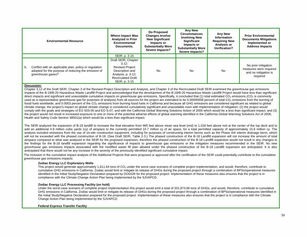
59
Environmental Resource
Where Impact Was Analyzed in Prior
Environmental Documents.
Do Proposed Changes Involve New Significant
Impacts or Substantially More Severe Impacts?
Any New Circumstances Involving New
Significant Impacts or
Substantially More Severe Impacts?
Any New Information
Requiring New Analysis or
Verification?
Prior Environmental Documents Mitigations
Implemented or Address Impacts
SEIR, p. 3-15
b. Conflict with an applicable plan, policy or regulation adopted for the purpose of reducing the emission of greenhouse gases?
Draft SEIR, Chapter 3.12;
Revised Project Description and
Analysis, p. 3-12; Recirculated Draft
SEIR, p. 3-15
No No No
No prior mitigation measures were required
and no mitigation is required
Discussion: Chapter 3.12 of the Draft SEIR, Chapter 3 of the Revised Project Description and Analysis, and Chapter 3 of the Recirculated Draft SEIR examined the greenhouse gas emissions impacts of the B-18/B-20 Hazardous Waste Landfill Project and acknowledged that the development of the B-18/B-20 Hazardous Waste Landfill Project would have less than significant direct impacts and significant and unavoidable cumulative impacts on greenhouse gas emissions. Specifically, it concluded that (1) total estimated CO2 emissions (CO2 is commonly used as a representative greenhouse gas for purposes of analysis) from all sources for the project are estimated to be 0.00000008 percent of total CO2 emissions from the burning of fossil fuels worldwide, and 0.0003 percent of the CO2 emissions from burning fossil fuels in California and because all GHG emissions are considered significant as related to global climate change, the project’s impact on global climate change is considered cumulatively significant and unavoidable even with implementation of mitigation; (2) the project would comply with the goals and strategies of EO S03-05 and EO S-07, and with the California Global Warming Solutions Action of 2006 which would be a less than significant impact; and (3) the project would not result in increased exposure to one or more of the potential adverse effects of global warming identified in the California Global Warming Solutions Act of 2006, Health and Safety Code Section 38501(a) which would be a less than significant impact.
The SEIR analyzed the expansion of B-18 landfill to increase the final elevation from 965 feet above mean sea level (msl) to 1,018 feet above msl at the center of the top deck and to add an additional 4.9 million cubic yards (cy) of airspace to the currently permitted 10.7 million cy of air space, for a total permitted capacity of approximately 15.6 million cy. The analysis included emissions from the use of on-site construction equipment, including for purposes of constructing interim berms such as the Phase IIIA interim drainage berm, which will not be exceeded with the phased construction of B-18. (See Draft SEIR, Table 2-3.) The phased construction of the B-18 Landfill expansion will not increase the amount of total airspace compared to what was analyzed in the SEIR for the proposed expansion, therefore the phased construction of the B-18 Landfill expansion would not result in any changes to the findings for the B-18 landfill expansion regarding the significance of impacts to greenhouse gas emissions or the mitigation measures recommended in the SEIR. No new greenhouse gas emissions impacts associated with the modified waste fill plan allowed under the phased construction of the B-18 Landfill expansion are anticipated. It is also anticipated that there would not be any increase in the severity of the previously identified significant cumulative impact.
The inclusion in the cumulative impact analysis of the Additional Projects that were proposed or approved after the certification of the SEIR could potentially contribute to the cumulative greenhouse gas emissions impacts:
Zodiac Energy LLC Exploratory Wells This project would generate approximately 1,611.64 tons of CO2 under the worst case scenario of complete project implementation, and would, therefore, contribute to cumulative GHG emissions in California. Zodiac would limit or mitigate its release of GHGs during the proposed project through a combination of BPSs/operational measures identified in the Initial Study/Negative Declaration prepared by DOGGR for the proposed project. Implementation of these measures also ensures that the project is in compliance with the Climate Change Action Plan being implemented by the SJVAPCD. Zodiac Energy LLC Processing Facility (on hold) Under the worst-case scenario of complete project implementation this project would emit a total of 201,873.66 tons of GHGs, and would, therefore, contribute to cumulative GHG emissions in California. Zodiac would limit or mitigate its release of GHGs during the proposed project through a combination of BPSs/operational measures identified in the Initial Study/Negative Declaration prepared for the proposed project. Implementation of these measures also ensures that the project is in compliance with the Climate Change Action Plan being implemented by the SJVAPCD. Federal Express Transfer Facility
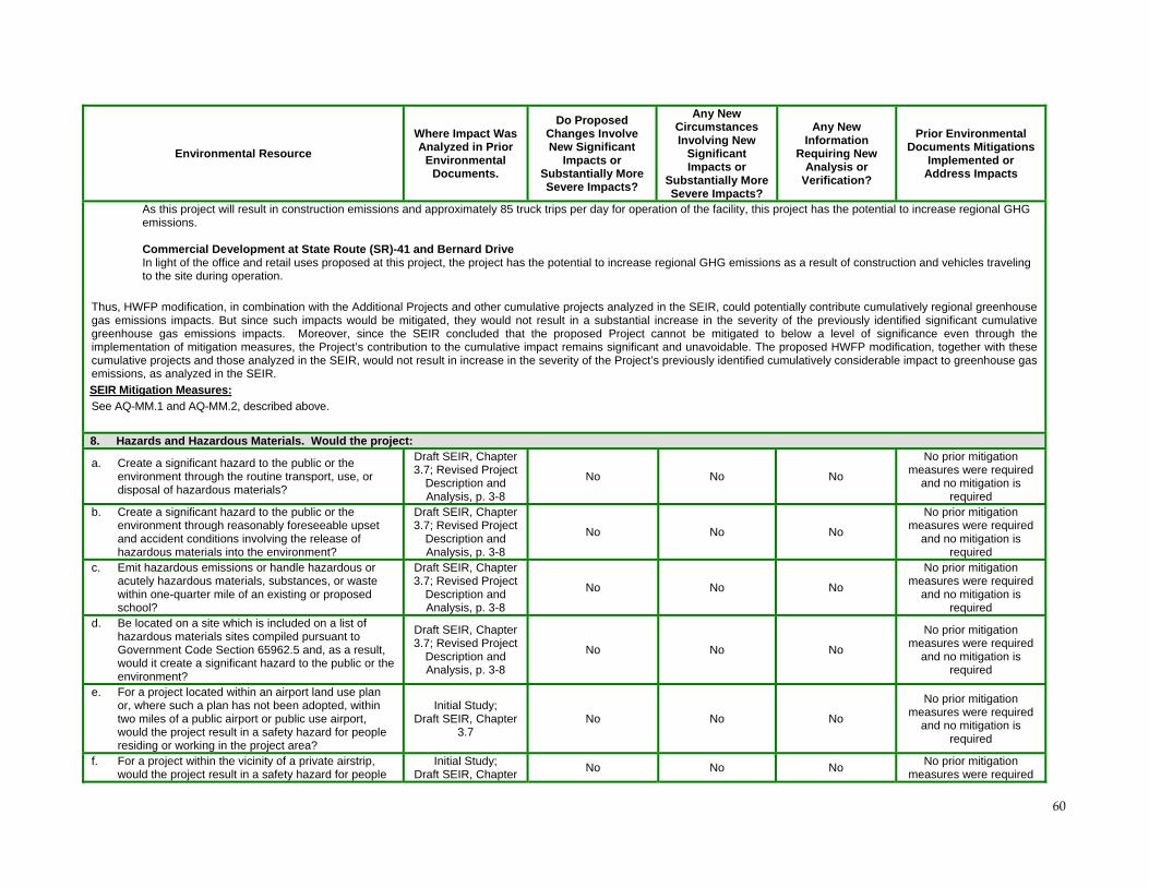
60
Environmental Resource
Where Impact Was Analyzed in Prior
Environmental Documents.
Do Proposed Changes Involve New Significant
Impacts or Substantially More Severe Impacts?
Any New Circumstances Involving New
Significant Impacts or
Substantially More Severe Impacts?
Any New Information
Requiring New Analysis or
Verification?
Prior Environmental Documents Mitigations
Implemented or Address Impacts
As this project will result in construction emissions and approximately 85 truck trips per day for operation of the facility, this project has the potential to increase regional GHG emissions. Commercial Development at State Route (SR)-41 and Bernard Drive In light of the office and retail uses proposed at this project, the project has the potential to increase regional GHG emissions as a result of construction and vehicles traveling to the site during operation.
Thus, HWFP modification, in combination with the Additional Projects and other cumulative projects analyzed in the SEIR, could potentially contribute cumulatively regional greenhouse gas emissions impacts. But since such impacts would be mitigated, they would not result in a substantial increase in the severity of the previously identified significant cumulative greenhouse gas emissions impacts. Moreover, since the SEIR concluded that the proposed Project cannot be mitigated to below a level of significance even through the implementation of mitigation measures, the Project’s contribution to the cumulative impact remains significant and unavoidable. The proposed HWFP modification, together with these cumulative projects and those analyzed in the SEIR, would not result in increase in the severity of the Project’s previously identified cumulatively considerable impact to greenhouse gas emissions, as analyzed in the SEIR.
SEIR Mitigation Measures:
See AQ-MM.1 and AQ-MM.2, described above.
8. Hazards and Hazardous Materials. Would the project:
a. Create a significant hazard to the public or the environment through the routine transport, use, or disposal of hazardous materials?
Draft SEIR, Chapter 3.7; Revised Project
Description and Analysis, p. 3-8
No No No
No prior mitigation measures were required
and no mitigation is required
b. Create a significant hazard to the public or the environment through reasonably foreseeable upset and accident conditions involving the release of hazardous materials into the environment?
Draft SEIR, Chapter 3.7; Revised Project
Description and Analysis, p. 3-8
No No No
No prior mitigation measures were required
and no mitigation is required
c. Emit hazardous emissions or handle hazardous or acutely hazardous materials, substances, or waste within one-quarter mile of an existing or proposed school?
Draft SEIR, Chapter 3.7; Revised Project
Description and Analysis, p. 3-8
No No No
No prior mitigation measures were required
and no mitigation is required
d. Be located on a site which is included on a list of hazardous materials sites compiled pursuant to Government Code Section 65962.5 and, as a result, would it create a significant hazard to the public or the environment?
Draft SEIR, Chapter 3.7; Revised Project
Description and Analysis, p. 3-8
No No No
No prior mitigation measures were required
and no mitigation is required
e. For a project located within an airport land use plan or, where such a plan has not been adopted, within two miles of a public airport or public use airport, would the project result in a safety hazard for people residing or working in the project area?
Initial Study; Draft SEIR, Chapter
3.7 No No No
No prior mitigation measures were required
and no mitigation is required
f. For a project within the vicinity of a private airstrip, would the project result in a safety hazard for people
Initial Study; Draft SEIR, Chapter
No No No No prior mitigation
measures were required
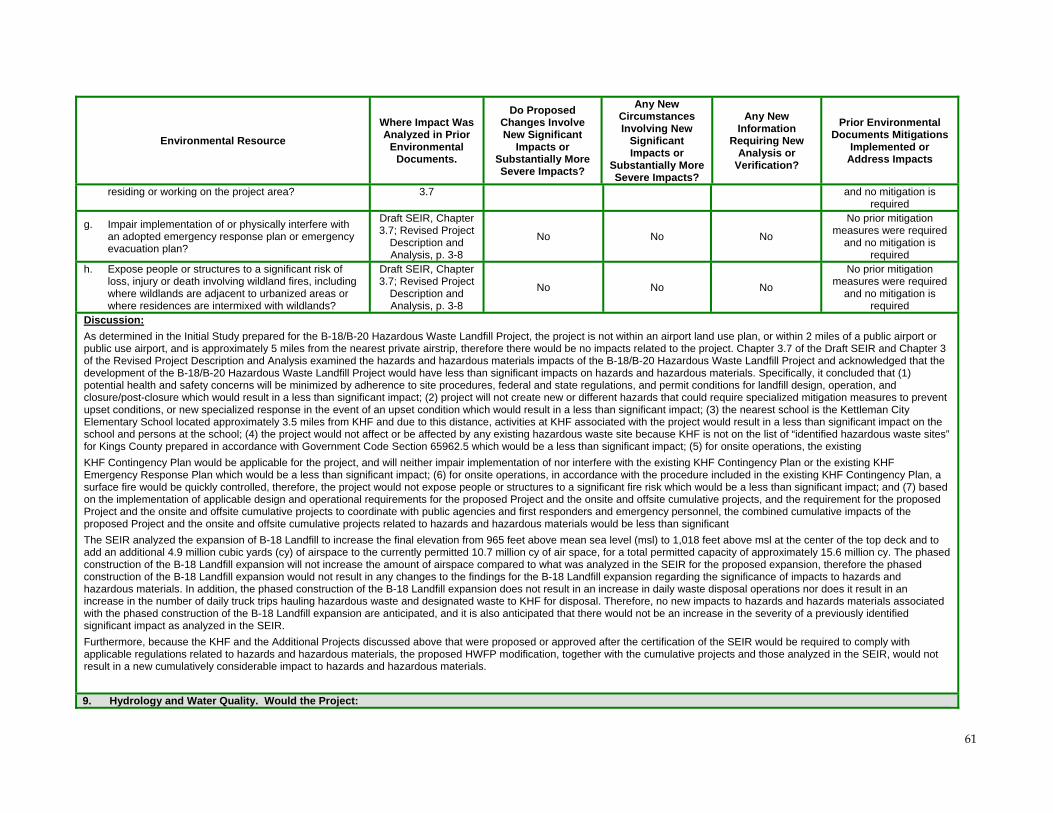
61
Environmental Resource
Where Impact Was Analyzed in Prior
Environmental Documents.
Do Proposed Changes Involve New Significant
Impacts or Substantially More Severe Impacts?
Any New Circumstances Involving New
Significant Impacts or
Substantially More Severe Impacts?
Any New Information
Requiring New Analysis or
Verification?
Prior Environmental Documents Mitigations
Implemented or Address Impacts
residing or working on the project area? 3.7 and no mitigation is required
g. Impair implementation of or physically interfere with an adopted emergency response plan or emergency evacuation plan?
Draft SEIR, Chapter 3.7; Revised Project
Description and Analysis, p. 3-8
No No No
No prior mitigation measures were required
and no mitigation is required
h. Expose people or structures to a significant risk of loss, injury or death involving wildland fires, including where wildlands are adjacent to urbanized areas or where residences are intermixed with wildlands?
Draft SEIR, Chapter 3.7; Revised Project
Description and Analysis, p. 3-8
No No No
No prior mitigation measures were required
and no mitigation is required
Discussion:
As determined in the Initial Study prepared for the B-18/B-20 Hazardous Waste Landfill Project, the project is not within an airport land use plan, or within 2 miles of a public airport or public use airport, and is approximately 5 miles from the nearest private airstrip, therefore there would be no impacts related to the project. Chapter 3.7 of the Draft SEIR and Chapter 3 of the Revised Project Description and Analysis examined the hazards and hazardous materials impacts of the B-18/B-20 Hazardous Waste Landfill Project and acknowledged that the development of the B-18/B-20 Hazardous Waste Landfill Project would have less than significant impacts on hazards and hazardous materials. Specifically, it concluded that (1) potential health and safety concerns will be minimized by adherence to site procedures, federal and state regulations, and permit conditions for landfill design, operation, and closure/post-closure which would result in a less than significant impact; (2) project will not create new or different hazards that could require specialized mitigation measures to prevent upset conditions, or new specialized response in the event of an upset condition which would result in a less than significant impact; (3) the nearest school is the Kettleman City Elementary School located approximately 3.5 miles from KHF and due to this distance, activities at KHF associated with the project would result in a less than significant impact on the school and persons at the school; (4) the project would not affect or be affected by any existing hazardous waste site because KHF is not on the list of “identified hazardous waste sites” for Kings County prepared in accordance with Government Code Section 65962.5 which would be a less than significant impact; (5) for onsite operations, the existing
KHF Contingency Plan would be applicable for the project, and will neither impair implementation of nor interfere with the existing KHF Contingency Plan or the existing KHF Emergency Response Plan which would be a less than significant impact; (6) for onsite operations, in accordance with the procedure included in the existing KHF Contingency Plan, a surface fire would be quickly controlled, therefore, the project would not expose people or structures to a significant fire risk which would be a less than significant impact; and (7) based on the implementation of applicable design and operational requirements for the proposed Project and the onsite and offsite cumulative projects, and the requirement for the proposed Project and the onsite and offsite cumulative projects to coordinate with public agencies and first responders and emergency personnel, the combined cumulative impacts of the proposed Project and the onsite and offsite cumulative projects related to hazards and hazardous materials would be less than significant
The SEIR analyzed the expansion of B-18 Landfill to increase the final elevation from 965 feet above mean sea level (msl) to 1,018 feet above msl at the center of the top deck and to add an additional 4.9 million cubic yards (cy) of airspace to the currently permitted 10.7 million cy of air space, for a total permitted capacity of approximately 15.6 million cy. The phased construction of the B-18 Landfill expansion will not increase the amount of airspace compared to what was analyzed in the SEIR for the proposed expansion, therefore the phased construction of the B-18 Landfill expansion would not result in any changes to the findings for the B-18 Landfill expansion regarding the significance of impacts to hazards and hazardous materials. In addition, the phased construction of the B-18 Landfill expansion does not result in an increase in daily waste disposal operations nor does it result in an increase in the number of daily truck trips hauling hazardous waste and designated waste to KHF for disposal. Therefore, no new impacts to hazards and hazards materials associated with the phased construction of the B-18 Landfill expansion are anticipated, and it is also anticipated that there would not be an increase in the severity of a previously identified significant impact as analyzed in the SEIR.
Furthermore, because the KHF and the Additional Projects discussed above that were proposed or approved after the certification of the SEIR would be required to comply with applicable regulations related to hazards and hazardous materials, the proposed HWFP modification, together with the cumulative projects and those analyzed in the SEIR, would not result in a new cumulatively considerable impact to hazards and hazardous materials.
9. Hydrology and Water Quality. Would the Project:
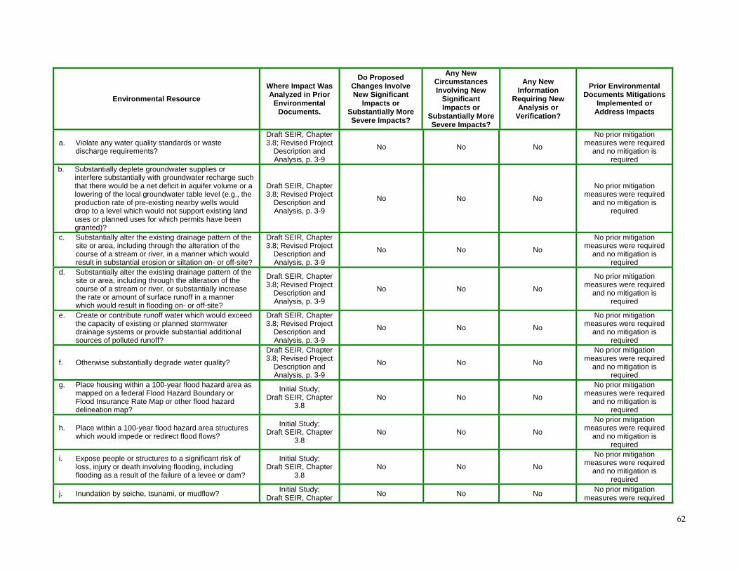
62
Environmental Resource
Where Impact Was Analyzed in Prior
Environmental Documents.
Do Proposed Changes Involve New Significant
Impacts or Substantially More Severe Impacts?
Any New Circumstances Involving New
Significant Impacts or
Substantially More Severe Impacts?
Any New Information
Requiring New Analysis or
Verification?
Prior Environmental Documents Mitigations
Implemented or Address Impacts
a. Violate any water quality standards or waste discharge requirements?
Draft SEIR, Chapter 3.8; Revised Project
Description and Analysis, p. 3-9
No No No
No prior mitigation measures were required
and no mitigation is required
b. Substantially deplete groundwater supplies or interfere substantially with groundwater recharge such that there would be a net deficit in aquifer volume or a lowering of the local groundwater table level (e.g., the production rate of pre-existing nearby wells would drop to a level which would not support existing land uses or planned uses for which permits have been granted)?
Draft SEIR, Chapter 3.8; Revised Project
Description and Analysis, p. 3-9
No No No
No prior mitigation measures were required
and no mitigation is required
c. Substantially alter the existing drainage pattern of the site or area, including through the alteration of the course of a stream or river, in a manner which would result in substantial erosion or siltation on- or off-site?
Draft SEIR, Chapter 3.8; Revised Project
Description and Analysis, p. 3-9
No No No
No prior mitigation measures were required
and no mitigation is required
d. Substantially alter the existing drainage pattern of the site or area, including through the alteration of the course of a stream or river, or substantially increase the rate or amount of surface runoff in a manner which would result in flooding on- or off-site?
Draft SEIR, Chapter 3.8; Revised Project
Description and Analysis, p. 3-9
No No No
No prior mitigation measures were required
and no mitigation is required
e. Create or contribute runoff water which would exceed the capacity of existing or planned stormwater drainage systems or provide substantial additional sources of polluted runoff?
Draft SEIR, Chapter 3.8; Revised Project
Description and Analysis, p. 3-9
No No No
No prior mitigation measures were required
and no mitigation is required
f. Otherwise substantially degrade water quality?
Draft SEIR, Chapter 3.8; Revised Project
Description and Analysis, p. 3-9
No No No
No prior mitigation measures were required
and no mitigation is required
g. Place housing within a 100-year flood hazard area as mapped on a federal Flood Hazard Boundary or Flood Insurance Rate Map or other flood hazard delineation map?
Initial Study; Draft SEIR, Chapter
3.8 No No No
No prior mitigation measures were required
and no mitigation is required
h. Place within a 100-year flood hazard area structures which would impede or redirect flood flows?
Initial Study; Draft SEIR, Chapter
3.8 No No No
No prior mitigation measures were required
and no mitigation is required
i. Expose people or structures to a significant risk of loss, injury or death involving flooding, including flooding as a result of the failure of a levee or dam?
Initial Study; Draft SEIR, Chapter
3.8 No No No
No prior mitigation measures were required
and no mitigation is required
j. Inundation by seiche, tsunami, or mudflow? Initial Study;
Draft SEIR, Chapter No No No
No prior mitigation measures were required
63
Environmental Resource
Where Impact Was Analyzed in Prior
Environmental Documents.
Do Proposed Changes Involve New Significant
Impacts or Substantially More Severe Impacts?
Any New Circumstances Involving New
Significant Impacts or
Substantially More Severe Impacts?
Any New Information
Requiring New Analysis or
Verification?
Prior Environmental Documents Mitigations
Implemented or Address Impacts
3.8 and no mitigation is required
Discussion:
As determined in the Initial Study prepared for the B-18/B-20 project, because of the arid nature and location of the site, the project will not result in impacts related to flooding, seiche, tsunami, or mudflow or place housing or other structures within in a 100-year flood hazard area. Chapter 3.8 of the Draft SEIR and Chapter 3 of the Revised Project Description and Analysis examined the hydrology and water quality impacts of the B-18/B-20 project and acknowledged that the development of the B-18/B-20 project would have less than significant impacts on hydrology and water quality. Specifically, it concluded that (1) the project would include drainage and erosion control features that would be designed to accommodate the peak storm water flows in accordance with all applicable regulations which would be a less than significant impact; (2) the project would be designed to meet state and federal requirements for hazardous waste and designated waste landfills, including but not limited to: landfill liner and leachate management systems, drainage control, groundwater monitoring, and installation of final cover which would be a less than significant impact to groundwater quality; (3) continued use of potable water from the City of Avenal and continued use of non-potable water from the private Hewitson well for the project will not impact water supplies for Kettleman City or other neighboring groundwater users which would be a less than significant impact to groundwater supply; and (4) cumulative impacts due to the project and the onsite and offsite cumulative project would be mitigated to a less than significant level which would result in less than significant cumulative impacts to hydrology and water quality resources.
As described in Technical Report A and Technical Report C to this Addendum & IS/Checklist, each phase of the phased construction of the B-18 Landfill expansion (Phase IIIA and IIIB) will be constructed in accordance with the specifications and CQA Plan contained in the Engineering and Design Report. (See Technical Report A, including technical appendices which are incorporated by reference herein.) The construction requirements for the liner system, however, will not be modified from that identified in the SEIR. Procedures used to construct the Phase III clay liner will be the same as those that were used to construct the Phase I and II clay liner.
The design of Phase III will tie into the existing leachate collection and removal system (LCRS). The Phase IIIA LCRS will function as designed to continue ensuring, as with other areas of the landfill, that the leachate depth over the liner of Phase III does not exceed 30 cm (one foot). (See Cal Code Regs., title 22, section 66264.301.) Specifically, Phase IIIA will be constructed such that leachate from Phase IIIA will be able to flow directly into the Phase IA LCRS. Thus, except for the temporary lined containment berm at the edge of Phase IIIA/IIIB (see Sheet C-4A in Appendix A.2), no interim control measures will be required. Stormwater contained on the north side of this temporary berm (i.e., between the berm and the Phase IIIA waste mass) will be treated as leachate and will be handled in the same manner as leachate that is collected in the existing B-18 leachate storage tanks (located on the concrete riser pads). (See also Appendix A, Cal Code Regs., title 22, sections 4.8.1, 4.9.6.) Monitoring of the primary and secondary LCRS and vadose zones will continue during construction of Phase III. (Appendix A, Cal Code Regs., title 22, section Cal Code Regs., title 22, section 4.8.2-4.8.4.) No new significant adverse water quality impacts would result from the phased construction of B-18 as proposed and conditioned.
An interim 10-foot high soil berm will be constructed between Phase IIIA and Phase IIIB along the area of the existing perimeter road. (See Appendix A, pp. 29, 41.) This berm will provide a physical delineation between the two phases and will provide run-on and run-off containment of stormwater, including from the worst case 24-hour 100-year probably maximum precipitation (PMP) storm event. (See Cal Code Regs., title 22, section 66264.25; Appendix A, pp. 26, 29, 60-64.) This temporary berm will prevent stormwater run-off from the 24-hour PMP storm event from leaving the Phase IIIA area. It will also prevent stormwater run-on from a 24-hour PMP event from entering the Phase IIIA area from the south. (See Appendix A, Cal Code Regs., title 22, section Cal Code Regs., title 22, sections 5.5.5 and 5.5.4.) The stormwater run-off volume from the 24-hour, PMP storm event captured on the north side of the proposed interim Phase IIIA drainage berm is calculated to be 24,500 cubic feet. The proposed interim Phase IIIA berm will be constructed to a height of 10 feet and will have a capacity of 52,100 cubic feet (assuming 1 foot of freeboard). Therefore, the proposed interim Phase IIIA drainage berm will have sufficient capacity to contain the flows from the 24-hour, PMP event with a freeboard greater than 1 foot. Once construction is complete, the interim berm will be dismantled and the soil used onsite.
The existing Northeast B-18 Containment Basin has a capacity of approximately 30 acre-feet. If the 24-hour, PMP storm event occurs during the construction of Phase III (i.e., before the South Containment Basin comes online), it is predicted that runoff to the existing NE B-18 Containment Basin would exceed its capacity by approximately 14 acre-feet. A 21-inch orifice outlet will be set approximately 3 feet below the top of the existing NE B-18 Containment Basin berm to prevent overtopping of this basin during a 24-hour PMP event should one
64
Environmental Resource
Where Impact Was Analyzed in Prior
Environmental Documents.
Do Proposed Changes Involve New Significant
Impacts or Substantially More Severe Impacts?
Any New Circumstances Involving New
Significant Impacts or
Substantially More Severe Impacts?
Any New Information
Requiring New Analysis or
Verification?
Prior Environmental Documents Mitigations
Implemented or Address Impacts
occur. The peak flows from the orifice outlet would be 17 cfs. The excess water from the outlet system will be conveyed by gravity pipe to the site’s existing East Retention Basin located approximately 2,000 feet to the north. The capacity of the existing East Retention Basin is approximately 50 acre feet. The East Retention Basin has a spillway in the event flow to the basin is greater than the capacity and the water would be released. This is a permitted NPDES discharge point. Stormwater from Phase IIIB would be unable to run onto Phase IIIA during construction of Phase IIIB because the top of the temporary Phase IIIA berm will be much higher than the high point of the Phase IIIB floor bench. (See Appendix A, § 4.9.1.)
The design and size of the berm is consistent with the SEIR and impacts considered therein. (see Draft SEIR Sections 2.10.4.1, 3.3.3.3.1.) and all applicable regulatory requirements. It is also consistent with historic onsite stormwater drainage control measures. (See Draft SEIR, Section 2.10.4.1, Table 2-7.) As shown in the Engineering and Design Report and supporting studies (see Appendix J.3) the berm has been sized to contain the 24-hour PMP event; thus, no pumping would be required to prevent overtopping in the event of a 24-hour PMP storm. Other stormwater controls, such as the perimeter channel and brow ditches, within the watershed of Phase IIIA will be constructed for run-on and run-off control during the interim period. The South Containment Basin will be constructed during Phase IIIB.
A temporary intermediate fill slope condition could also result from construction of Phase IIIA for a short time. A cross section through the temporary slope was evaluated to ensure static stability and compliance with applicable requirements. (See Technical Report A, pp. 57-5856-56a,and Appendix H.4.) A static stability analysis was conducted for the Phase IIIA intermediate waste slope. The result in Table 5.2 for this condition is a static factor of safety of 1.5 which is considered acceptable. (Technical Report A, p. 58.) The Phase IIIA stability analyses were performed for the south-facing 2H:1V interim waste slope. The remaining waste slopes formed during Phase IIIA will be built to final closure grades as analyzed previously as part of the final closure stability analysis. (See Figure 5.3.) Therefore, no new impacts to hydrology and water quality associated with the phased construction of the B-18 Landfill expansion are anticipated, and it is also anticipated that there would not be an increase in the severity of a previously identified significant impact as analyzed in the SEIR.
The inclusion in the cumulative impact analysis of the Additional Projects that were proposed or approved after the certification of the SEIR would not cause a cumulative hydrology and water quality impact:
Zodiac Energy LLC Exploratory Wells The project will not cause direct or indirect wastewater discharges that will result in an exposure to levels of hazardous materials that will adversely affect human health, wildlife or plant species. The project will comply with all water quality and waste discharge standards established by the Central Valley RWQCB. The project will not degrade groundwater quality or interfere with groundwater recharge, or deplete groundwater resources in a manner that will cause water-related hazards such as subsidence. In compliance with DOGGR regulations, Zodiac will install and cement surface casing to prevent blowouts and contamination of fresh water aquifers. DOGGR regulations specify that the base of fresh water must be protected with cemented casing to prevent any contamination from migrating fluids encountered in oil and gas zones. The regulations also specify that oil and gas zones must be protected with cemented casing to prevent any contamination from infiltrating water. DOGGR engineers review the drilling and completion operations to ensure these requirements have been met. Compliance with the General Permit to Discharge Storm Water with Construction Activity (WQ Order No. 99-08-DWQ) is required; thus,, the project will not alter the current drainage pattern of the proposed project in a manner that will promote flooding, erosion or siltation either on or off the sites. Zodiac Energy LLC Processing Facility (on hold) Compliance with the General Permit to Discharge Storm Water with Construction Activity (WQ Order No. 99-08-DWQ) is required. The project will comply with all water quality and waste discharge standards established by the Central Valley RWQCB. A SWPPP will be developed and BMP’s will be utilized to ensure that the project will not violate any water quality standards or waste discharge requirements. Federal Express Transfer Facility Any potential construction impacts regarding hydrology and water quality will be subject to BMPs and mitigation. As a result, construction related impacts will be less than significant. The project will also increase impervious surfaces, but such areas, like the parking area, aisles and access drives, shall be graded and drained so as to dispose of surface water, with the design and specifications of such work subject to the approval of the County Director of Public Works. Commercial Development at State Route (SR)-41 and Bernard Drive
65
Environmental Resource
Where Impact Was Analyzed in Prior
Environmental Documents.
Do Proposed Changes Involve New Significant
Impacts or Substantially More Severe Impacts?
Any New Circumstances Involving New
Significant Impacts or
Substantially More Severe Impacts?
Any New Information
Requiring New Analysis or
Verification?
Prior Environmental Documents Mitigations
Implemented or Address Impacts
Any potential construction impacts regarding hydrology and water quality will be subject to BMPs and mitigation. As a result, construction related impacts will be less than significant. The project will also increase impervious surfaces, but such areas, like the parking area, aisles and access drives, shall be graded and drained so as to dispose of surface water, with the design and specifications of such work subject to the approval of the County Director of Public Works. Drainage for the site will be into the storm drain system of the community.
Thus, because such impacts would be mitigated, the HWFP modification , in combination with the Additional Projects and other cumulative projects analyzed in the SEIR, would not result in a new cumulatively significant impact to hydrology and water quality.
66
Environmental Resource
Where Impact Was Analyzed in Prior
Environmental Documents.
Do Proposed Changes Involve New Significant
Impacts or Substantially More Severe Impacts?
Any New Circumstances Involving New
Significant Impacts or
Substantially More Severe Impacts?
Any New Information
Requiring New Analysis or
Verification?
Prior Environmental Documents Mitigations
Implemented or Address Impacts
10. Land Use and Planning. Would the project:
a. Physically divide an established community? Initial Study;
Draft SEIR, Chapter 3.9
No No No
No prior mitigation measures were required
and no mitigation is required
b. Conflict with any applicable land use plan, policy, or regulation of an agency with jurisdiction over the project (including, but not limited to the general plan, specific plan, local coastal program, or zoning ordinance) adopted for the purpose of avoiding or mitigating an environmental effect?
Draft SEIR, Chapter 3.9; Revised Project
Description and Analysis, p. 3-9.
No No No TT-MM.1 TT-MM.2
c. Conflict with any applicable habitat conservation plan or natural community conservation plan?
Initial Study; Draft SEIR, Chapter
3.9 No No No
No prior mitigation measures were required
and no mitigation is required
Discussion:
As determined in the Initial Study prepared for the B-18/B-20 Hazardous Waste Landfill Project, because of the nature of the location of the site, the project will not physically divide an established community or conflict with any applicable habitat conservation plan or natural community conservation plan. Chapter 3.9 of the Draft SEIR and Chapter 3 of the Revised Project Description and Analysis examined the land use and planning impacts of the B-18/B-20 Hazardous Waste Landfill Project and acknowledged that the development of the B-18/B-20 Hazardous Waste Landfill Project would have less than significant impacts on land use and planning with mitigation measures. Specifically, it concluded that (1) the project is consistent with the current General Plan designation of the site as solid waste disposal is a conditional use within the site’s AG-40 zone, but the proposed Project will require issuance of a new Conditional Use Permit which would be a less than significant impact; (2) the project would not involve any parcel included in Williamson Act contracts and would not affect offsite agricultural operations which would be a less than significant impact; (3) the project is consistent with County’s Hazardous Waste Management Plan (CHWMP) which identifies KHF as a hazardous waste management facility that can be expanded and also identifies it as a facility that provides adequate and projected capacity for disposal of hazardous waste, which would be a less than significant impact; (4) Project would be consistent with the SJVUAPCD’s Air Quality Attainment Plans for Ozone and PM10 which would be a less than significant impact; (5) the project would be consistent with the County Noise Standard as it would not result in noise levels that exceed 70 dBA at the KHF property boundary which would be a less than significant impact; (6) the project would contribute to the future reduction in the level of service (LOS) on the segments of SR-41 and I-5 that would be used to continue to transport hazardous waste and designated waste to the KHF which are being affected by growth in the region which results in an incompatibility with the Kings County Regional Transportation Plan which would be a less than significant impact after mitigation; and (7) the project and the onsite and offsite cumulative projects would not result in cumulative land use impacts.
The phased construction of the B-18 Landfill expansion will not increase the amount of airspace compared to what was analyzed in the SEIR for the proposed expansion, and would be consistent with the Kings County General Plan designation of KHF as a “waste disposal and treatment site.” Accordingly, the phased construction of the B-18 Landfill expansion would not result in any changes to the findings for the B-18 landfill expansion regarding the significance of impacts to land use and planning. Therefore, no new impacts to land use and planning associated with the phased construction of the B-18 Landfill expansion are anticipated, and it is also anticipated that there would not be an increase in the severity of a previously identified significant impact as analyzed in the SEIR.
Furthermore, because the KHF and the Additional Projects discussed above that were proposed or approved after the certification of the SEIR are not in proximity to each other, the proposed HWFP modification, together with these cumulative projects and those analyzed in the SEIR, would not result in any new cumulatively significant impacts to land use and planning.
SEIR Mitigation Measures:
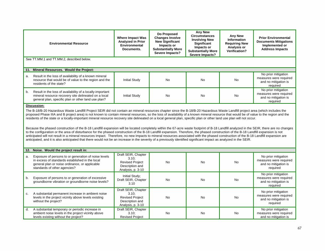
67
Environmental Resource
Where Impact Was Analyzed in Prior
Environmental Documents.
Do Proposed Changes Involve New Significant
Impacts or Substantially More Severe Impacts?
Any New Circumstances Involving New
Significant Impacts or
Substantially More Severe Impacts?
Any New Information
Requiring New Analysis or
Verification?
Prior Environmental Documents Mitigations
Implemented or Address Impacts
See TT.MM.1 and TT.MM.2, described below.
11. Mineral Resources. Would the Project:
a. Result in the loss of availability of a known mineral resource that would be of value to the region and the residents of the state?
Initial Study No No No
No prior mitigation measures were required
and no mitigation is required
b. Result in the loss of availability of a locally-important mineral resource recovery site delineated on a local general plan, specific plan or other land use plan?
Initial Study No No No
No prior mitigation measures were required
and no mitigation is required
Discussion:
The B-18/B-20 Hazardous Waste Landfill Project SEIR did not contain an mineral resources chapter since the B-18/B-20 Hazardous Waste Landfill project area (which includes the proposed Phase IIIA and B project area) is not known to contain mineral resources, so the loss of availability of a known mineral resource that would be of value to the region and the residents of the state or a locally-important mineral resource recovery site delineated on a local general plan, specific plan or other land use plan will not occur.
Because the phased construction of the B-18 Landfill expansion will be located completely within the 67-acre waste footprint of B-18 Landfill analyzed in the SEIR, there are no changes to the configuration or the area of disturbance for the phased construction of the B-18 Landfill expansion. Therefore, the phased construction of the B-18 Landfill expansion is not anticipated will not result in a mineral resources impact. Therefore, no new impacts to mineral resources associated with the phased construction of the B-18 Landfill expansion are anticipated, and it is also anticipated that there would not be an increase in the severity of a previously identified significant impact as analyzed in the SEIR.
12. Noise. Would the project result in:
a. Exposure of persons to or generation of noise levels in excess of standards established in the local general plan or noise ordinance, or applicable standards of other agencies?
Draft SEIR, Chapter 3.10;
Revised Project Description and Analysis, p. 3-10
No No No
No prior mitigation measures were required
and no mitigation is required
b. Exposure of persons to or generation of excessive groundborne vibration or groundborne noise levels?
Initial Study; Draft SEIR, Chapter
3.10 No No No
No prior mitigation measures were required
and no mitigation is required
c. A substantial permanent increase in ambient noise levels in the project vicinity above levels existing without the project?
Draft SEIR, Chapter 3.10;
Revised Project Description and Analysis, p. 3-10
No No No
No prior mitigation measures were required
and no mitigation is required
d. A substantial temporary or periodic increase in ambient noise levels in the project vicinity above levels existing without the project?
Draft SEIR, Chapter 3.10;
Revised Project No No No
No prior mitigation measures were required
and no mitigation is
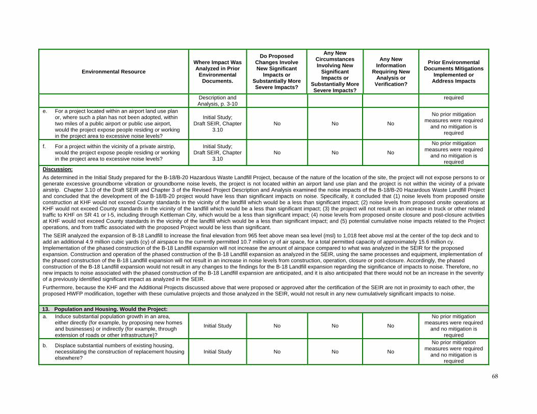
68
Environmental Resource
Where Impact Was Analyzed in Prior
Environmental Documents.
Do Proposed Changes Involve New Significant
Impacts or Substantially More Severe Impacts?
Any New Circumstances Involving New
Significant Impacts or
Substantially More Severe Impacts?
Any New Information
Requiring New Analysis or
Verification?
Prior Environmental Documents Mitigations
Implemented or Address Impacts
Description and Analysis, p. 3-10
required
e. For a project located within an airport land use plan or, where such a plan has not been adopted, within two miles of a public airport or public use airport, would the project expose people residing or working in the project area to excessive noise levels?
Initial Study; Draft SEIR, Chapter
3.10 No No No
No prior mitigation measures were required
and no mitigation is required
f. For a project within the vicinity of a private airstrip, would the project expose people residing or working in the project area to excessive noise levels?
Initial Study; Draft SEIR, Chapter
3.10 No No No
No prior mitigation measures were required
and no mitigation is required
Discussion:
As determined in the Initial Study prepared for the B-18/B-20 Hazardous Waste Landfill Project, because of the nature of the location of the site, the project will not expose persons to or generate excessive groundborne vibration or groundborne noise levels, the project is not located within an airport land use plan and the project is not within the vicinity of a private airstrip. Chapter 3.10 of the Draft SEIR and Chapter 3 of the Revised Project Description and Analysis examined the noise impacts of the B-18/B-20 Hazardous Waste Landfill Project and concluded that the development of the B-18/B-20 project would have less than significant impacts on noise. Specifically, it concluded that (1) noise levels from proposed onsite construction at KHF would not exceed County standards in the vicinity of the landfill which would be a less than significant impact; (2) noise levels from proposed onsite operations at KHF would not exceed County standards in the vicinity of the landfill which would be a less than significant impact; (3) the project will not result in an increase in truck or other related traffic to KHF on SR 41 or I-5, including through Kettleman City, which would be a less than significant impact; (4) noise levels from proposed onsite closure and post-closure activities at KHF would not exceed County standards in the vicinity of the landfill which would be a less than significant impact; and (5) potential cumulative noise impacts related to the Project operations, and from traffic associated with the proposed Project would be less than significant.
The SEIR analyzed the expansion of B-18 Landfill to increase the final elevation from 965 feet above mean sea level (msl) to 1,018 feet above msl at the center of the top deck and to add an additional 4.9 million cubic yards (cy) of airspace to the currently permitted 10.7 million cy of air space, for a total permitted capacity of approximately 15.6 million cy. Implementation of the phased construction of the B-18 Landfill expansion will not increase the amount of airspace compared to what was analyzed in the SEIR for the proposed expansion. Construction and operation of the phased construction of the B-18 Landfill expansion as analyzed in the SEIR, using the same processes and equipment, implementation of the phased construction of the B-18 Landfill expansion will not result in an increase in noise levels from construction, operation, closure or post-closure. Accordingly, the phased construction of the B-18 Landfill expansion would not result in any changes to the findings for the B-18 Landfill expansion regarding the significance of impacts to noise. Therefore, no new impacts to noise associated with the phased construction of the B-18 Landfill expansion are anticipated, and it is also anticipated that there would not be an increase in the severity of a previously identified significant impact as analyzed in the SEIR.
Furthermore, because the KHF and the Additional Projects discussed above that were proposed or approved after the certification of the SEIR are not in proximity to each other, the proposed HWFP modification, together with these cumulative projects and those analyzed in the SEIR, would not result in any new cumulatively significant impacts to noise.
13. Population and Housing. Would the Project: a. Induce substantial population growth in an area,
either directly (for example, by proposing new homes and businesses) or indirectly (for example, through extension of roads or other infrastructure)?
Initial Study No No No
No prior mitigation measures were required
and no mitigation is required
b. Displace substantial numbers of existing housing, necessitating the construction of replacement housing elsewhere?
Initial Study No No No
No prior mitigation measures were required
and no mitigation is required
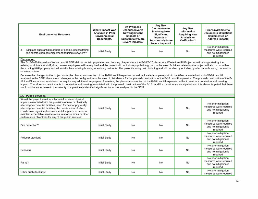
69
Environmental Resource
Where Impact Was Analyzed in Prior
Environmental Documents.
Do Proposed Changes Involve New Significant
Impacts or Substantially More Severe Impacts?
Any New Circumstances Involving New
Significant Impacts or
Substantially More Severe Impacts?
Any New Information
Requiring New Analysis or
Verification?
Prior Environmental Documents Mitigations
Implemented or Address Impacts
c. Displace substantial numbers of people, necessitating the construction of replacement housing elsewhere?
Initial Study No No No
No prior mitigation measures were required
and no mitigation is required
Discussion: The B-18/B-20 Hazardous Waste Landfill SEIR did not contain population and housing chapter since the B-18/B-20 Hazardous Waste Landfill Project would be supported by the existing work force at KHF; thus, no new employees will be required and the project will not induce population growth in the area. Activities related to the project will also occur within the existing KHF property and will not displace existing housing or existing residents. The project is not growth inducing and will not directly or indirectly affect area housing, population or infrastructure.
Because the changes to the project under the phased construction of the B-18 Landfill expansion would be located completely within the 67-acre waste footprint of B-18 Landfill analyzed in the SEIR, there are no changes to the configuration or the area of disturbance for the phased construction of the B-18 Landfill expansion. The phased construction of the B-18 Landfill expansion would also not require any additional employees. Therefore, the phased construction of the B-18 Landfill expansion will not result in a population and housing impact. Therefore, no new impacts to population and housing associated with the phased construction of the B-18 Landfill expansion are anticipated, and it is also anticipated that there would not be an increase in the severity of a previously identified significant impact as analyzed in the SEIR.
14. Public Services. Would the project result in substantial adverse physical impacts associated with the provision of new or physically altered governmental facilities, need for new or physically altered governmental facilities, the construction of which could cause significant environmental impacts, in order to maintain acceptable service ratios, response times or other performance objectives for any of the public services:
Initial Study No No No
No prior mitigation measures were required
and no mitigation is required
Fire protection? Initial Study No No No
No prior mitigation measures were required
and no mitigation is required
Police protection? Initial Study No No No
No prior mitigation measures were required
and no mitigation is required
Schools? Initial Study No No No
No prior mitigation measures were required
and no mitigation is required
Parks? Initial Study No No No
No prior mitigation measures were required
and no mitigation is required
Other public facilities? Initial Study No No No No prior mitigation
measures were required
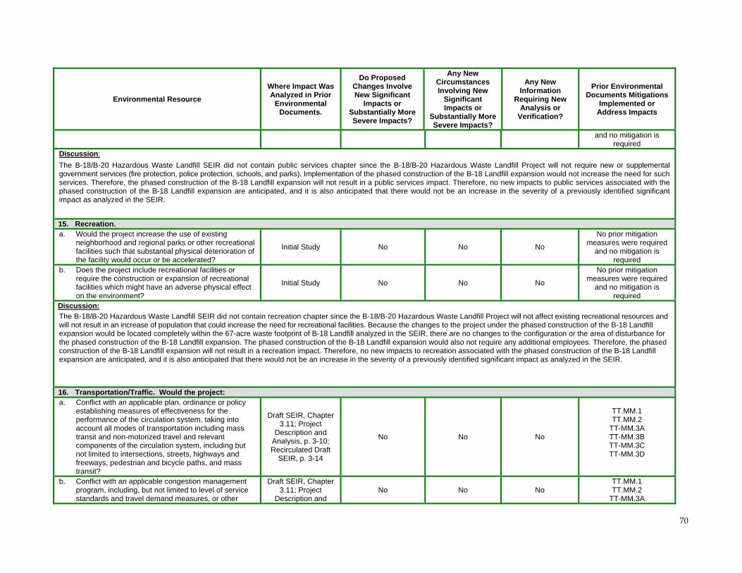
70
Environmental Resource
Where Impact Was Analyzed in Prior
Environmental Documents.
Do Proposed Changes Involve New Significant
Impacts or Substantially More Severe Impacts?
Any New Circumstances Involving New
Significant Impacts or
Substantially More Severe Impacts?
Any New Information
Requiring New Analysis or
Verification?
Prior Environmental Documents Mitigations
Implemented or Address Impacts
and no mitigation is required
Discussion:
The B-18/B-20 Hazardous Waste Landfill SEIR did not contain public services chapter since the B-18/B-20 Hazardous Waste Landfill Project will not require new or supplemental government services (fire protection, police protection, schools, and parks). Implementation of the phased construction of the B-18 Landfill expansion would not increase the need for such services. Therefore, the phased construction of the B-18 Landfill expansion will not result in a public services impact. Therefore, no new impacts to public services associated with the phased construction of the B-18 Landfill expansion are anticipated, and it is also anticipated that there would not be an increase in the severity of a previously identified significant impact as analyzed in the SEIR.
15. Recreation. a. Would the project increase the use of existing
neighborhood and regional parks or other recreational facilities such that substantial physical deterioration of the facility would occur or be accelerated?
Initial Study No No No
No prior mitigation measures were required
and no mitigation is required
b. Does the project include recreational facilities or require the construction or expansion of recreational facilities which might have an adverse physical effect on the environment?
Initial Study No No No
No prior mitigation measures were required
and no mitigation is required
Discussion:
The B-18/B-20 Hazardous Waste Landfill SEIR did not contain recreation chapter since the B-18/B-20 Hazardous Waste Landfill Project will not affect existing recreational resources and will not result in an increase of population that could increase the need for recreational facilities. Because the changes to the project under the phased construction of the B-18 Landfill expansion would be located completely within the 67-acre waste footprint of B-18 Landfill analyzed in the SEIR, there are no changes to the configuration or the area of disturbance for the phased construction of the B-18 Landfill expansion. The phased construction of the B-18 Landfill expansion would also not require any additional employees. Therefore, the phased construction of the B-18 Landfill expansion will not result in a recreation impact. Therefore, no new impacts to recreation associated with the phased construction of the B-18 Landfill expansion are anticipated, and it is also anticipated that there would not be an increase in the severity of a previously identified significant impact as analyzed in the SEIR.
16. Transportation/Traffic. Would the project: a. Conflict with an applicable plan, ordinance or policy
establishing measures of effectiveness for the performance of the circulation system, taking into account all modes of transportation including mass transit and non-motorized travel and relevant components of the circulation system, including but not limited to intersections, streets, highways and freeways, pedestrian and bicycle paths, and mass transit?
Draft SEIR, Chapter 3.11; Project
Description and Analysis, p. 3-10; Recirculated Draft
SEIR, p. 3-14
No No No
TT.MM.1 TT.MM.2
TT-MM.3A TT-MM.3B TT-MM.3C TT-MM.3D
b. Conflict with an applicable congestion management program, including, but not limited to level of service standards and travel demand measures, or other
Draft SEIR, Chapter 3.11; Project
Description and No No No
TT.MM.1 TT.MM.2
TT-MM.3A
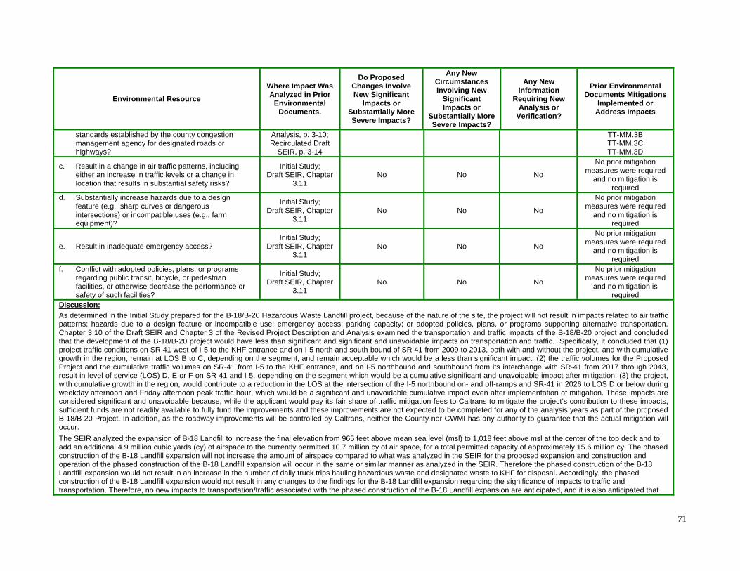
71
Environmental Resource
Where Impact Was Analyzed in Prior
Environmental Documents.
Do Proposed Changes Involve New Significant
Impacts or Substantially More Severe Impacts?
Any New Circumstances Involving New
Significant Impacts or
Substantially More Severe Impacts?
Any New Information
Requiring New Analysis or
Verification?
Prior Environmental Documents Mitigations
Implemented or Address Impacts
standards established by the county congestion management agency for designated roads or highways?
Analysis, p. 3-10; Recirculated Draft
SEIR, p. 3-14
TT-MM.3B TT-MM.3C TT-MM.3D
c. Result in a change in air traffic patterns, including either an increase in traffic levels or a change in location that results in substantial safety risks?
Initial Study; Draft SEIR, Chapter
3.11 No No No
No prior mitigation measures were required
and no mitigation is required
d. Substantially increase hazards due to a design feature (e.g., sharp curves or dangerous intersections) or incompatible uses (e.g., farm equipment)?
Initial Study; Draft SEIR, Chapter
3.11 No No No
No prior mitigation measures were required
and no mitigation is required
e. Result in inadequate emergency access? Initial Study;
Draft SEIR, Chapter 3.11
No No No
No prior mitigation measures were required
and no mitigation is required
f. Conflict with adopted policies, plans, or programs regarding public transit, bicycle, or pedestrian facilities, or otherwise decrease the performance or safety of such facilities?
Initial Study; Draft SEIR, Chapter
3.11 No No No
No prior mitigation measures were required
and no mitigation is required
Discussion:
As determined in the Initial Study prepared for the B-18/B-20 Hazardous Waste Landfill project, because of the nature of the site, the project will not result in impacts related to air traffic patterns; hazards due to a design feature or incompatible use; emergency access; parking capacity; or adopted policies, plans, or programs supporting alternative transportation. Chapter 3.10 of the Draft SEIR and Chapter 3 of the Revised Project Description and Analysis examined the transportation and traffic impacts of the B-18/B-20 project and concluded that the development of the B-18/B-20 project would have less than significant and significant and unavoidable impacts on transportation and traffic. Specifically, it concluded that (1) project traffic conditions on SR 41 west of I-5 to the KHF entrance and on I-5 north and south-bound of SR 41 from 2009 to 2013, both with and without the project, and with cumulative growth in the region, remain at LOS B to C, depending on the segment, and remain acceptable which would be a less than significant impact; (2) the traffic volumes for the Proposed Project and the cumulative traffic volumes on SR-41 from I-5 to the KHF entrance, and on I-5 northbound and southbound from its interchange with SR-41 from 2017 through 2043, result in level of service (LOS) D, E or F on SR-41 and I-5, depending on the segment which would be a cumulative significant and unavoidable impact after mitigation; (3) the project, with cumulative growth in the region, would contribute to a reduction in the LOS at the intersection of the I-5 northbound on- and off-ramps and SR-41 in 2026 to LOS D or below during weekday afternoon and Friday afternoon peak traffic hour, which would be a significant and unavoidable cumulative impact even after implementation of mitigation. These impacts are considered significant and unavoidable because, while the applicant would pay its fair share of traffic mitigation fees to Caltrans to mitigate the project’s contribution to these impacts, sufficient funds are not readily available to fully fund the improvements and these improvements are not expected to be completed for any of the analysis years as part of the proposed B 18/B 20 Project. In addition, as the roadway improvements will be controlled by Caltrans, neither the County nor CWMI has any authority to guarantee that the actual mitigation will occur.
The SEIR analyzed the expansion of B-18 Landfill to increase the final elevation from 965 feet above mean sea level (msl) to 1,018 feet above msl at the center of the top deck and to add an additional 4.9 million cubic yards (cy) of airspace to the currently permitted 10.7 million cy of air space, for a total permitted capacity of approximately 15.6 million cy. The phased construction of the B-18 Landfill expansion will not increase the amount of airspace compared to what was analyzed in the SEIR for the proposed expansion and construction and operation of the phased construction of the B-18 Landfill expansion will occur in the same or similar manner as analyzed in the SEIR. Therefore the phased construction of the B-18 Landfill expansion would not result in an increase in the number of daily truck trips hauling hazardous waste and designated waste to KHF for disposal. Accordingly, the phased construction of the B-18 Landfill expansion would not result in any changes to the findings for the B-18 Landfill expansion regarding the significance of impacts to traffic and transportation. Therefore, no new impacts to transportation/traffic associated with the phased construction of the B-18 Landfill expansion are anticipated, and it is also anticipated that
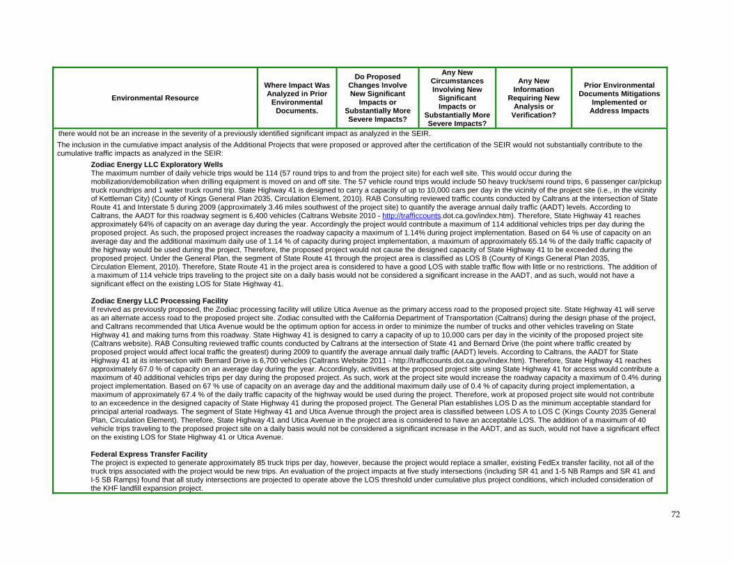
72
Environmental Resource
Where Impact Was Analyzed in Prior
Environmental Documents.
Do Proposed Changes Involve New Significant
Impacts or Substantially More Severe Impacts?
Any New Circumstances Involving New
Significant Impacts or
Substantially More Severe Impacts?
Any New Information
Requiring New Analysis or
Verification?
Prior Environmental Documents Mitigations
Implemented or Address Impacts
there would not be an increase in the severity of a previously identified significant impact as analyzed in the SEIR.
The inclusion in the cumulative impact analysis of the Additional Projects that were proposed or approved after the certification of the SEIR would not substantially contribute to the cumulative traffic impacts as analyzed in the SEIR:
Zodiac Energy LLC Exploratory Wells The maximum number of daily vehicle trips would be 114 (57 round trips to and from the project site) for each well site. This would occur during the mobilization/demobilization when drilling equipment is moved on and off site. The 57 vehicle round trips would include 50 heavy truck/semi round trips, 6 passenger car/pickup truck roundtrips and 1 water truck round trip. State Highway 41 is designed to carry a capacity of up to 10,000 cars per day in the vicinity of the project site (i.e., in the vicinity of Kettleman City) (County of Kings General Plan 2035, Circulation Element, 2010). RAB Consulting reviewed traffic counts conducted by Caltrans at the intersection of State Route 41 and Interstate 5 during 2009 (approximately 3.46 miles southwest of the project site) to quantify the average annual daily traffic (AADT) levels. According to Caltrans, the AADT for this roadway segment is 6,400 vehicles (Caltrans Website 2010 - http://trafficcounts.dot.ca.gov/index.htm). Therefore, State Highway 41 reaches approximately 64% of capacity on an average day during the year. Accordingly the project would contribute a maximum of 114 additional vehicles trips per day during the proposed project. As such, the proposed project increases the roadway capacity a maximum of 1.14% during project implementation. Based on 64 % use of capacity on an average day and the additional maximum daily use of 1.14 % of capacity during project implementation, a maximum of approximately 65.14 % of the daily traffic capacity of the highway would be used during the project. Therefore, the proposed project would not cause the designed capacity of State Highway 41 to be exceeded during the proposed project. Under the General Plan, the segment of State Route 41 through the project area is classified as LOS B (County of Kings General Plan 2035, Circulation Element, 2010). Therefore, State Route 41 in the project area is considered to have a good LOS with stable traffic flow with little or no restrictions. The addition of a maximum of 114 vehicle trips traveling to the project site on a daily basis would not be considered a significant increase in the AADT, and as such, would not have a significant effect on the existing LOS for State Highway 41. Zodiac Energy LLC Processing Facility If revived as previously proposed, the Zodiac processing facility will utilize Utica Avenue as the primary access road to the proposed project site. State Highway 41 will serve as an alternate access road to the proposed project site. Zodiac consulted with the California Department of Transportation (Caltrans) during the design phase of the project, and Caltrans recommended that Utica Avenue would be the optimum option for access in order to minimize the number of trucks and other vehicles traveling on State Highway 41 and making turns from this roadway. State Highway 41 is designed to carry a capacity of up to 10,000 cars per day in the vicinity of the proposed project site (Caltrans website). RAB Consulting reviewed traffic counts conducted by Caltrans at the intersection of State 41 and Bernard Drive (the point where traffic created by proposed project would affect local traffic the greatest) during 2009 to quantify the average annual daily traffic (AADT) levels. According to Caltrans, the AADT for State Highway 41 at its intersection with Bernard Drive is 6,700 vehicles (Caltrans Website 2011 - http://trafficcounts.dot.ca.gov/index.htm). Therefore, State Highway 41 reaches approximately 67.0 % of capacity on an average day during the year. Accordingly, activities at the proposed project site using State Highway 41 for access would contribute a maximum of 40 additional vehicles trips per day during the proposed project. As such, work at the project site would increase the roadway capacity a maximum of 0.4% during project implementation. Based on 67 % use of capacity on an average day and the additional maximum daily use of 0.4 % of capacity during project implementation, a maximum of approximately 67.4 % of the daily traffic capacity of the highway would be used during the project. Therefore, work at proposed project site would not contribute to an exceedence in the designed capacity of State Highway 41 during the proposed project. The General Plan establishes LOS D as the minimum acceptable standard for principal arterial roadways. The segment of State Highway 41 and Utica Avenue through the project area is classified between LOS A to LOS C (Kings County 2035 General Plan, Circulation Element). Therefore, State Highway 41 and Utica Avenue in the project area is considered to have an acceptable LOS. The addition of a maximum of 40 vehicle trips traveling to the proposed project site on a daily basis would not be considered a significant increase in the AADT, and as such, would not have a significant effect on the existing LOS for State Highway 41 or Utica Avenue. Federal Express Transfer Facility The project is expected to generate approximately 85 truck trips per day, however, because the project would replace a smaller, existing FedEx transfer facility, not all of the truck trips associated with the project would be new trips. An evaluation of the project impacts at five study intersections (including SR 41 and 1-5 NB Ramps and SR 41 and I-5 SB Ramps) found that all study intersections are projected to operate above the LOS threshold under cumulative plus project conditions, which included consideration of the KHF landfill expansion project.
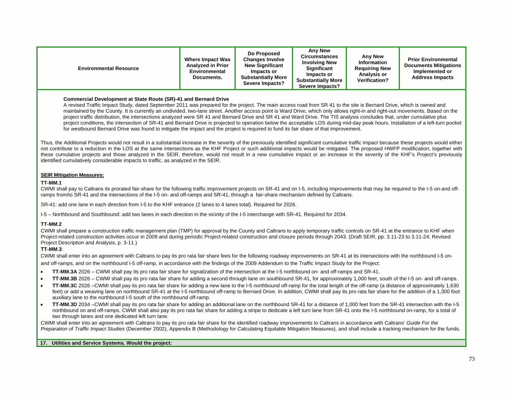
73
Environmental Resource
Where Impact Was Analyzed in Prior
Environmental Documents.
Do Proposed Changes Involve New Significant
Impacts or Substantially More Severe Impacts?
Any New Circumstances Involving New
Significant Impacts or
Substantially More Severe Impacts?
Any New Information
Requiring New Analysis or
Verification?
Prior Environmental Documents Mitigations
Implemented or Address Impacts
Commercial Development at State Route (SR)-41 and Bernard Drive A revised Traffic Impact Study, dated September 2011 was prepared for the project. The main access road from SR 41 to the site is Bernard Drive, which is owned and maintained by the County. It is currently an undivided, two-lane street. Another access point is Ward Drive, which only allows right-in and right-out movements. Based on the project traffic distribution, the intersections analyzed were SR 41 and Bernard Drive and SR 41 and Ward Drive. The TIS analysis concludes that, under cumulative plus project conditions, the intersection of SR-41 and Bernard Drive is projected to operation below the acceptable LOS during mid-day peak hours. Installation of a left-turn pocket for westbound Bernard Drive was found to mitigate the impact and the project is required to fund its fair share of that improvement.
Thus, the Additional Projects would not result in a substantial increase in the severity of the previously identified significant cumulative traffic impact because these projects would either not contribute to a reduction in the LOS at the same intersections as the KHF Project or such additional impacts would be mitigated. The proposed HWFP modification, together with these cumulative projects and those analyzed in the SEIR, therefore, would not result in a new cumulative impact or an increase in the severity of the KHF’s Project’s previously identified cumulatively considerable impacts to traffic, as analyzed in the SEIR.
SEIR Mitigation Measures:
TT-MM.1 CWMI shall pay to Caltrans its prorated fair-share for the following traffic improvement projects on SR-41 and on I-5, including improvements that may be required to the I-5 on-and off-ramps from/to SR-41 and the intersections of the I-5 on- and off-ramps and SR-41, through a fair-share mechanism defined by Caltrans.
SR-41: add one lane in each direction from I-5 to the KHF entrance (2 lanes to 4 lanes total). Required for 2026.
I-5 – Northbound and Southbound: add two lanes in each direction in the vicinity of the I-5 interchange with SR-41. Required for 2034.
TT-MM.2 CWMI shall prepare a construction traffic management plan (TMP) for approval by the County and Caltrans to apply temporary traffic controls on SR-41 at the entrance to KHF when Project-related construction activities occur in 2009 and during periodic Project-related construction and closure periods through 2043. (Draft SEIR, pp. 3.11-23 to 3.11-24; Revised Project Description and Analysis, p. 3-11.) TT-MM.3: CWMI shall enter into an agreement with Caltrans to pay its pro rata fair share fees for the following roadway improvements on SR-41 at its intersections with the northbound I-5 on-
and off-ramps, and on the northbound I-5 off-ramp, in accordance with the findings of the 2009 Addendum to the Traffic Impact Study for the Project:
TT-MM.3A 2026 – CWMI shall pay its pro rata fair share for signalization of the intersection at the I-5 northbound on- and off-ramps and SR-41. TT-MM.3B 2026 – CWMI shall pay its pro rata fair share for adding a second through lane on southbound SR-41, for approximately 1,000 feet, south of the I-5 on- and off-ramps. TT-MM.3C 2026 –CWMI shall pay its pro rata fair share for adding a new lane to the I-5 northbound off-ramp for the total length of the off-ramp (a distance of approximately 1,630
feet) or add a weaving lane on northbound SR-41 at the I-5 northbound off-ramp to Bernard Drive. In addition, CWMI shall pay its pro rata fair share for the addition of a 1,300 foot auxiliary lane to the northbound I-5 south of the northbound off-ramp.
TT-MM.3D 2034 –CWMI shall pay its pro rata fair share for adding an additional lane on the northbound SR-41 for a distance of 1,000 feet from the SR-41 intersection with the I-5 northbound on and off-ramps. CWMI shall also pay its pro rata fair share for adding a stripe to dedicate a left turn lane from SR-41 onto the I-5 northbound on-ramp, for a total of two through lanes and one dedicated left turn lane.
CWMI shall enter into an agreement with Caltrans to pay its pro rata fair share for the identified roadway improvements to Caltrans in accordance with Caltrans’ Guide For the Preparation of Traffic Impact Studies (December 2002), Appendix B (Methodology for Calculating Equitable Mitigation Measures), and shall include a tracking mechanism for the funds.
17. Utilities and Service Systems. Would the project:
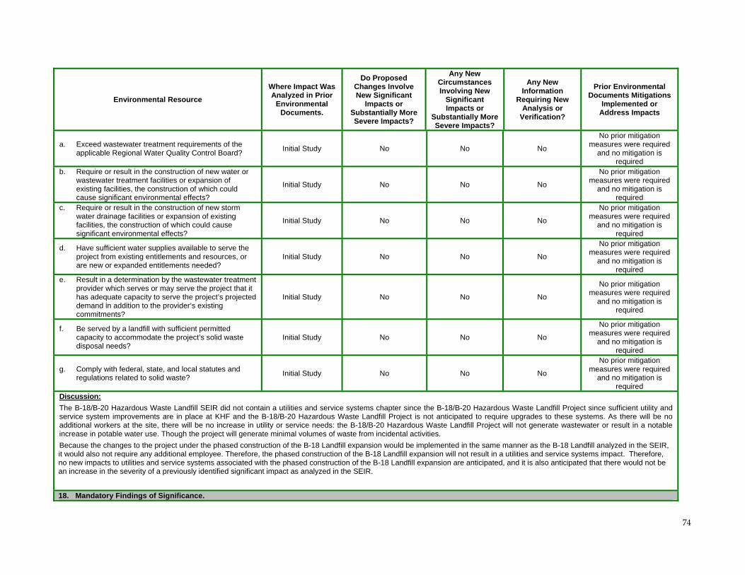
74
Environmental Resource
Where Impact Was Analyzed in Prior
Environmental Documents.
Do Proposed Changes Involve New Significant
Impacts or Substantially More Severe Impacts?
Any New Circumstances Involving New
Significant Impacts or
Substantially More Severe Impacts?
Any New Information
Requiring New Analysis or
Verification?
Prior Environmental Documents Mitigations
Implemented or Address Impacts
a. Exceed wastewater treatment requirements of the applicable Regional Water Quality Control Board?
Initial Study No No No
No prior mitigation measures were required
and no mitigation is required
b. Require or result in the construction of new water or wastewater treatment facilities or expansion of existing facilities, the construction of which could cause significant environmental effects?
Initial Study No No No
No prior mitigation measures were required
and no mitigation is required
c. Require or result in the construction of new storm water drainage facilities or expansion of existing facilities, the construction of which could cause significant environmental effects?
Initial Study No No No
No prior mitigation measures were required
and no mitigation is required
d. Have sufficient water supplies available to serve the project from existing entitlements and resources, or are new or expanded entitlements needed?
Initial Study No No No
No prior mitigation measures were required
and no mitigation is required
e. Result in a determination by the wastewater treatment provider which serves or may serve the project that it has adequate capacity to serve the project’s projected demand in addition to the provider’s existing commitments?
Initial Study No No No
No prior mitigation measures were required
and no mitigation is required
f. Be served by a landfill with sufficient permitted capacity to accommodate the project’s solid waste disposal needs?
Initial Study No No No
No prior mitigation measures were required
and no mitigation is required
g. Comply with federal, state, and local statutes and regulations related to solid waste?
Initial Study No No No
No prior mitigation measures were required
and no mitigation is required
Discussion:
The B-18/B-20 Hazardous Waste Landfill SEIR did not contain a utilities and service systems chapter since the B-18/B-20 Hazardous Waste Landfill Project since sufficient utility and service system improvements are in place at KHF and the B-18/B-20 Hazardous Waste Landfill Project is not anticipated to require upgrades to these systems. As there will be no additional workers at the site, there will be no increase in utility or service needs: the B-18/B-20 Hazardous Waste Landfill Project will not generate wastewater or result in a notable increase in potable water use. Though the project will generate minimal volumes of waste from incidental activities.
Because the changes to the project under the phased construction of the B-18 Landfill expansion would be implemented in the same manner as the B-18 Landfill analyzed in the SEIR, it would also not require any additional employee. Therefore, the phased construction of the B-18 Landfill expansion will not result in a utilities and service systems impact. Therefore, no new impacts to utilities and service systems associated with the phased construction of the B-18 Landfill expansion are anticipated, and it is also anticipated that there would not be an increase in the severity of a previously identified significant impact as analyzed in the SEIR.
18. Mandatory Findings of Significance.
75
Environmental Resource
Where Impact Was Analyzed in Prior
Environmental Documents.
Do Proposed Changes Involve New Significant
Impacts or Substantially More Severe Impacts?
Any New Circumstances Involving New
Significant Impacts or
Substantially More Severe Impacts?
Any New Information
Requiring New Analysis or
Verification?
Prior Environmental Documents Mitigations
Implemented or Address Impacts
a. Does the project have the potential to degrade the quality of the environment, substantially reduce the habitat of a fish or wildlife species, cause a fish or wildlife population to drop below self-sustaining levels, threaten to eliminate a plant or animal community, reduce the number or restrict the range of a rare or endangered plant or animal or eliminate important examples of the major periods of California history or prehistory?
Draft SEIR, Chapter 3.4
No No No
No prior mitigation measures were required
and no mitigation is required
b. Does the project have impacts that are individually limited, but cumulatively considerable? (“Cumulatively considerable” means that the incremental effects of a project are considerable when viewed in connection with the effects of past projects, the effects of other current projects, and the effects of probable future projects)?
Draft SEIR Chapters 3.2 through 3.12;
Project Description and Analysis,
Chapter 3; Recirculated Draft SEIR, Chapter 3
No No No Yes
(See MM identified above)
c. Does the project have environmental effects which will cause substantial adverse effects on human beings, either directly or indirectly?
Draft SEIR Chapters 3.2 through 3.12;
Project Description and Analysis,
Chapter 3; Recirculated Draft SEIR, Chapter 3
No No No
No prior mitigation measures were required
and no mitigation is required
Discussion:
The preceding analysis demonstrates that the proposed changes to the B-18/B-20 Hazardous Waste Landfill Project as a result of the phased construction of the B-18 Landfill expansion will not involve new significant impacts, that there are not any new circumstances involving new impacts and that there is not any new information requiring new analysis or verification. From these conclusions, it is determined that the phased construction of the B-18 Landfill expansion does not require changes to the prior conclusions reached in the certified SEIR for the B-18/B-20 Hazardous Waste Landfill Project and the effects discussed in the Mandatory Findings Checklist section above will not occur beyond those already anticipated in the certified SEIR for the B-18/B-20 Hazardous Waste Landfill Project as a consequence of the phased construction of the B-18 Landfill expansion. No additional environmental review is therefore required.
76
7.0 Findings and Conclusion The above evaluation and enclosed additional substantial evidence (e.g., Appendices A-C) supports the conclusion that preparation of a supplemental or subsequent EIR is not required prior to approval of the above-referenced Class III HWFP modification by DTSC, and that the Addendum and Initial Study/Environmental Checklist is the appropriate document for DTSC to prepare under CEQA for approval of the Class III HWFP modification request. There are no substantial changes proposed by the phased construction of the B-18 Landfill expansion or in the circumstances in which the project will be undertaken that require major revisions of the existing Final SEIR for the B-18/B-20 Hazardous Waste Disposal Project, or preparation of a new subsequent or supplemental EIR, due to the involvement of new significant environmental effects or a substantial increase in the severity of previously identified significant effects. As illustrated herein, the phased construction of the B-18 Landfill expansion is consistent with the Final SEIR and would involve only minor design modifications (CEQA Guidelines, section 15162, subdivision (a)). The current proposed phased construction of the B-18 Landfill expansion does not require major revisions to the Final SEIR for the B-18/B-20 Hazardous Waste Disposal Project. No new significant information or changes in circumstances for the B-18/B-20 Hazardous Waste Disposal Project have occurred since the adoption of the Final SEIR. The previous analysis completed for the B-18/B-20 Hazardous Waste Disposal Project under CEQA and included in the Final SEIR therefore remains adequate, as considered and supplemented herein by the & Addendum and Initial Study/Environmental Checklist prepared pursuant to CEQA. In addition, consideration of the Additional Projects for which applications were either filed or approved with the County after the SEIR was certified in the analysis of the Project’s cumulative impacts does not result in new significant cumulative impacts or substantial increase in the severity of a cumulative impacts, and does not change the findings and conclusions in the certified SEIR concerning the potential cumulatively considerable impacts of the proposed Project. CWMI as the owner/operator of the KHF remains obligated to comply with all applicable mitigation measures in the Mitigation Monitoring and Reporting Plan adopted as part of the Final SEIR by the Kings County Board of Supervisors, all applicable conditions of approval included in the Conditional Use Permit for the B-18/B-20 Hazardous Waste Disposal Project adopted by the Kings County Board of Supervisors, and all applicable regulatory requirements..
8.0 Mitigation Monitoring Program As required by Pub. Resources Code, Section 21081.6 and CEQA Guidelines section 15097, a Mitigation Monitoring and Reporting Program (MMRP) has been prepared for the B-18/B-20 Hazardous Waste Disposal Project by Kings County as the lead CEQA agency to monitor the implementation of the mitigation measures that have been adopted for the project. Any long-term monitoring of mitigation measures imposed on the overall Project will be implemented through the MMRP and any additional permit conditions imposed by DTSC under its statutory authority under Chapter 6.5 of the HSC and Cal. Code Regs., title 22.
77
9.0 References Cal EPA and DPH, 2010. Investigation of Birth Defects and Community Exposures in Kettleman City December. California Dept. of Public Health/ California Environmental Protection Agency. 2010.
Investigation of Birth Defects and Community Exposures in Kettleman City, CA. December.
Cal/EPA&CDPH. 2011. California Environmental Protection Agency (Cal/EPA) and California
Department of Public Health (CDPH). Follow-Up to Kettleman City Investigation: An Update. 2011.
http://www.calepa.ca.gov/EnvJustice/Documents/2011/KC/UpdateOct.pdf
Chemical Waste Management. 2012. Kettleman City and Kettleman Hills Facility: Study Findings
and Biomonitoring. May.
CH2M HILL. 2009. Final Subsequent Environmental Impact Report (SEIR) B-18/B-20 Hazardous
Waste Disposal Project Kettleman Hills Facility Chemical Waste Management, Inc. (SCH No.
2005041064). September.
CH2M HILL. 2009. Recirculated Portions of the Draft Subsequent Environmental Impact Report
(SEIR) B-18/B-20 Hazardous Waste Disposal Project Kettleman Hills Facility Chemical Waste
Management, Inc. May.
CH2M HILL. 2008. Revised Project Description and Analysis of the Draft Subsequent Environmental
Impact Report (SEIR) B-18/B-20 Hazardous Waste Disposal Project Kettleman Hills Facility Chemical
Waste Management, Inc. June.
CH2M HILL. 2008. The Draft Subsequent Environmental Impact Report (SEIR) B-18/B-20 Hazardous
Waste Disposal Project Kettleman Hills Facility Chemical Waste Management, Inc. March.
City of Avenal. 2010. Draft Initial Study and Negative Declaration 2009-2014 Housing Element Update. April DTSC. 2009. Application for Certification for the Avenal Energy Project, Commission Adoption Order (Docket No. 08-AFC-1; Order No. 09-1216-04). December. DOGGR. 2011. Initial Study/Negative Declaration for the Jaguar 2-3 and 2-15 Exploratory Wells. July. DOGGR. 2010. Initial Study/Negative Declaration Zodiac #4-9. September 20.
DOGGR. 2010. Initial Study/Negative Declaration Zodiac #1-10. September 20.
DOGGR. Permits to Conduct Well Operations No.’s P512-14; P512-115; P511-280; P511-206; P511-181; P511-207 and P511-205. Ecology and Environment, Inc. 2010. CEQA Initial Study / Mitigated Negative Declaration for the Avenal Photovoltaic Solar Farm Kings County California. January.
78
Ecology and Environment, Inc. 2010. CEQA Draft Mitigated Negative Declaration and Initial Study for the Avenal Park Photovoltaic Solar Farm Kings County California. August. Environmental Science Associates. 2009. Dudley Ridge Water District Transfer Project Initial Study/Negative Declaration. June. Environmental Science Associates. 2010. Irvine Ranch Water District/ Jackson Ranch Water Allocation Project Initial Study/ Negative Declaration. January. Golder Associates, Inc. 2011. Engineering and Design Report B-18 Landfill Phase III Expansion and Final Closure, Kettleman Hills Facility, Kettleman City, California August. Golder Associates, Inc. 2011. Surface Water Hydrology Calculations, Kettleman Hills Facility Landfill Unit B-18, Kettleman City, Kings County, California October. Hushmand Associates, Inc. 2011. Slope Stability Analysis Report, Kettleman Hills Facility Landfill Unit B-18, Kettleman City, Kings County October. Kettleman City Community Services District. 2011. Initial Study Mitigated Negative Declaration Kettleman City Water Treatment Plant and Commercial Water Storage Tanks. November. Luhdorff & Scalamini Consulting Engineers. 2009. Assessment of Potential Groundwater and Pumping Effects KHF B-18/B-20 Hazardous Waste Disposal Project. March. McCormick Biological, Inc. 2012. Rare Plant Survey Results For the Proposed Chemical Waste Management, Inc., B-18 Landfill Expansion. April. Memorandum of Agreement (MOA). 1988. Between the State Water Resources Control Board and the Department of Conservation Division of Oil and Gas. May. Perry, Robert H., Green, Don W. 1997. Perry’s Chemical Engineers’ Handbook Seventh Edition.
USEPA. 2011. U.S. Environmental Protection Agency (USEPA). EPA Information Sheet: Results of the Polychlorinated Biphenyl (PCB) Congener Study Chemical Waste Management Kettleman Hills Facility. January. [http://www.epa.gov/region9/kettleman/docs/pcb-congener-EPA-info-sheet.pdf] TRC. 2008. Application for Certification California Energy Commission Avenal Energy Vol I. February.
79
Wenck Associates, Inc. 2010. Final Dioxin-Like Polychlorinated biphenyl (PCB) Congeners Study November. Wenck Associates, Inc. 2011. Final 2011 Health Risk Assessment for the Chemical Waste Management, Inc. Kettleman Hills Facility. November. Wenck Associates, Inc. (Wenck). 2012. Draft Annual Screening Level Health Risk Assessment, October 2010 – September 2011. Prepared for Chemical Waste Management, Kettleman Hills Facility (KHF), Kings County, California. March. Yamabe & Horn Engineering, Inc., 2009, 2011. Traffic Impact Study for the FedEx Transfer Station
(Oct. 2009); and Addendum No. 1. (March 2011).
Yamabe & Horn Engineering, Inc. 2011. SR-41 and Bernard Drive Commercials in Kettleman City
(Sept. 2011).