adapting to drought and floods in the semi-arid landscape of santa
TRANSCRIPT
101The Geographical Bulletin 47(2): 101-118©2006 by Gamma Theta Upsilon
AbSTRACTThis paper analyzes the actions of key inter-
est groups and major institutional regulatory agreements that influence land use change and water demand in Santa Cruz County, Arizona, in order to better understand the capacity of residents in the county to adapt to hydroclimatic hazards (drought and flood-ing) . We found that there are strong special interest groups working in the region to ensure their own livelihoods and interests . At times, the actions of these groups enhance the adaptive capacity of the county, but their actions can also conflict with each other, pro-ducing a less-clear outcome for adaptation . We also note that government regulation at the binational, state and local scales supports water resource management and buffers the potential impacts of drought . Unfortunately, government regulatory policy has been less effective in mitigating flood concerns, and thus overall, the capacity of the county to adapt climate variability and change remains questionable . Lastly, the county’s unique po-sition on the U .S .-Mexico border challenges efforts to plan for climate related hazards .
Key Words: adaptive capacity, drought, flooding, water resource management, south-ern Arizona
INTROdUCTIONIt would seem paradoxical that a semi-arid
region such as the Sonora Desert of southern Arizona could be vulnerable to both drought and flooding . As strictly hydroclimatic phe-nomenon, drought tends to denote a lack of precipitation over an extended period of time, something to be anticipated in a desert environment . Flooding, however, implies a deluge of water at a rather unexpected pace, not at all anticipated by the average resident in a desert environment . Yet, many who have lived in the Sonora Desert for an extended period of their lives have experienced both droughts and floods . They are also likely to have experienced them as hazards, not merely climate related phenomena, and their experience of them is likely to have
Adapting to drought and floods in the Semi-Arid Landscape of Santa Cruz County, Arizona Cynthia L. Sorrensen Texas Tech UniversityDepartment of Economics and GeographyLubbock, Texas 79409E-mail: [email protected]
102
changed throughout their time of residence, depending on their own economic means of survival and on the array of historic and ongoing change in land use and land cover . The physical geography of southern Arizona’s Sonora Desert exhibits sharp contrasts in climate variability . The degree to which this variability then becomes hazardous drought or flooding, however, is related to human processes of adaptation .
Studying the impacts of drought, floods or other climate related hazards has been an on-going topic of research in geography (Blaikie et al . 1994; Cutter 2004) . With the prospects of global warming and the subsequent po-tential for climate-related events to be more frequent and more extreme, geographers, along with other climate change research-ers, are becoming ever more concerned with hazards issues (Kasperson and Kasperson 2001) . Social scientists typically situate these studies within a framework of vulnerability, though there is tremendous debate over exactly what constitutes vulnerability (Sor-rensen et al . 2005) . Regardless of definition, a more vulnerable population will experience a greater impact from climate-related haz-ards than a less vulnerable population . By studying vulnerability, we are better able to understand and anticipate the social impacts of hazards .
In recent years, important research organi-zations such as the Intergovernmental Panel on Climate Change have been promoting new research on vulnerability research as it relates to climate related hazards . Adapta-tion research—the study of what hinders or facilitates individuals or specific human-environment systems in their ability to re-spond to climate related events—is seen as a particularly high priority (McCarthy et al. 2001) . This focus on adaptation has a distinct advantage over studies that focus exclusively on vulnerability . While vulnerability studies tend to emphasize and explain the current unfavorable conditions of a population or area, an analysis of adaptation allows for a more proactive approach . By analyzing pro-cesses by which people adapt to change, it serves to empower those affected by change
to “do something about it”— to enable them to adapt in ways that reduce future vulner-ability (Finan et al . 2002) . This shift to more responsive research also reflects a broadening of spatial scale . In early work, climate change research pressed for international-scale re-sponses, whether through international research organizations such as IPCC, or through inter-governmental accords such as the Montreal Protocol on Substances that Deplete the Ozone Layer . Now, in addition to international efforts, local efforts are seen as vital, and empowering local institutions and people to plan for climate change is seen as a critical component of our ability to minimize impacts of climate change . If society wishes to prepare for climate-related hazards, especially as climate change increases the likelihood of major climatic shifts, under-standing processes of adaptation at all spatial scales as well as the capacity of individuals or populations to adapt in the future is increas-ingly important .
For the wider discipline of geography, the priority on adaptation research opens up an interesting dialogue and set of research questions . Adaptation as emphasized above implies an intentional or purposeful sort of change process, either individually or on a larger societal level . Geographers are frequently concerned with trying to under-stand and position the drivers of change, as is evidenced in the wide body of research that swings between viewing change as a result of societal structures and viewing change as an outcome of individual agency (see Sorrensen et al . 2005, this issue, for further elabora-tion) . Questions such as what constitutes ad-aptation, how it is socially constructed, and how it is influenced by structure or agency, reveal a fertile ground for social theorists and geographers that deal with human-environ-ment issues to engage pressing issues relating to climate change .
In this paper, we examine the capacity San-ta Cruz County, Arizona situated within the Sonora Desert along the border with Sonora, Mexico to adapt to climatic threats . Using a framework of adaptation research (see Sor-rensen et al . 2005, this issue, for further elab-
Cynthia L. Sorrensen
103
Adapting to Drought and Floods in the Semi-Arid Landscape of Santa Cruz County, Arizona
oration), we explore the influences of struc-ture and agency on adaptive capacity within Santa Cruz County, Arizona . In Santa Cruz County, situated in the Sonora Desert along the border with Sonora, Mexico, droughts and floods occur regularly in a increasingly urbanized landscape that is attracting new residents, industry, and development . The adaptive capacity of the county to temper these climate related hazards depends not only on the forward thinking of its citizens, but on land use dynamics that are occurring across the border, over which the county has little control . Yet, despite the transborder challenges, adaptation has occurred both as an incremental process and an intermittent one . The adaptive capacity of the county is presently dominated by structural forces as
manifested within water resource regula-tion and county development plans, but the actions of individuals and specific interest groups can not be discounted . Agency, as a force of adaptation that at times works with and against regulation, also influences the impacts of climate related hazards .
CLImATE ANd HydROLOGy IN SANTA CRUz COUNTy
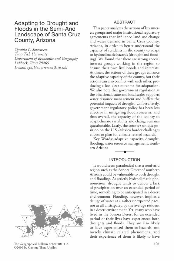
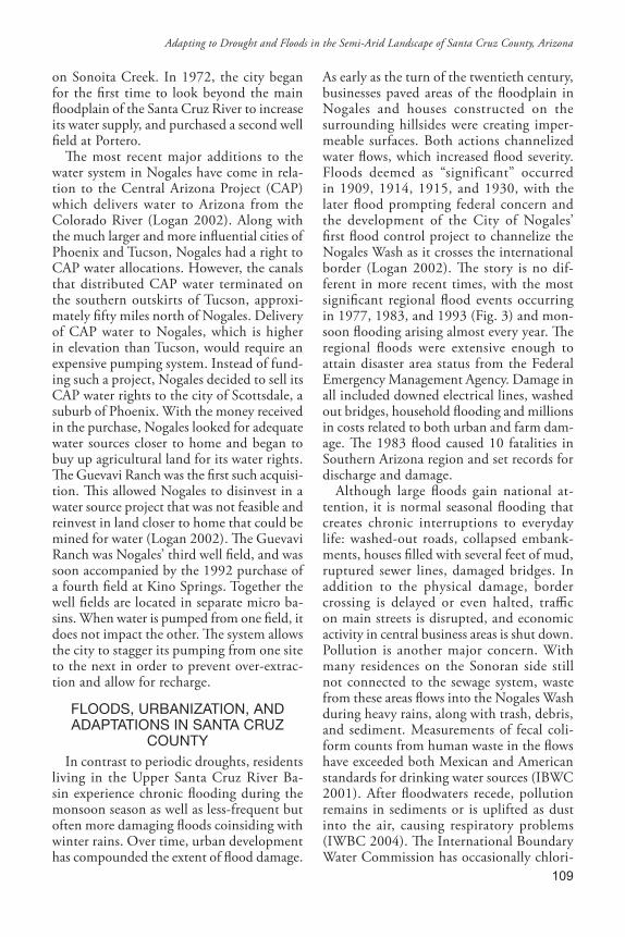
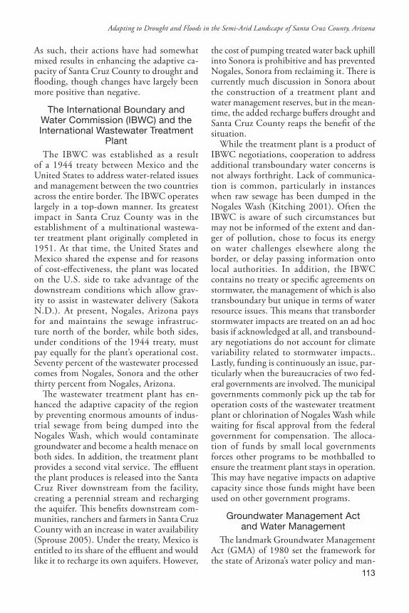
Santa Cruz County is located in southern Arizona on the border with Sonora, Mexico (Fig . 1) . It is situated within the Sonora Des-ert, a semi-arid to arid region with summer temperatures frequently reaching over 40° C . Annual precipitation is generally sparse, averaging from 40-50cm, but inter-annual varaibility is great and extended periods
!
!
!
!
!
Nogales
Santa Cruz River
U p p e r S a n t a C r u zR i v e r B a s i n
Nogales
Sonoita
Rio Rico
Patagonia
Santa Cruz County
Nogales Municipality Santa Cruz Municipality
0 105 Miles
! Cities / Towns
Rivers
International Boundary
County or Municipality Boundary
A r i z o n a , U S A
A r i z o n a , U S AS o n o r a , M e x i c o
S o n o r a , M e x i c oN
Figure 1: Map of the Upper Santa Cruz River Basin .
104
without significant rainfall have caused droughts throughout the time period for which climate records are available . Rainfall exhibits a bimodal summer/winter pattern that results from thunderstorms within the regional North American monsoon in summer and mid-latitude synoptic frontal systems in winter (Adams and Comrie 1997; Sheppard et al . 2002) . During the monsoon season, Santa Cruz County can experience localized flash flood runoff for brief periods, but precipitation generally evaporates quickly in the summer heat and permeation into the water table is limited . Winter rains can also cause flooding, and together with mountain snowfall are the major source of groundwater recharge .
Climate model predictions for Santa Cruz County that account for a potentially warmer average global temperature are far from reaching consensus, but there is little doubt that the region will increasingly be affected by droughts and floods . Temperature change tends to be modeled more consistently with predictions for fall and springtime increases of 1 .6° – 2 .2 ° C, and winter and summer in-creases up to 3 .72 ° C (Watson et . al . 1998) . In Tucson, Arizona, just 60 miles north of the Santa Cruz County line, century-scale mean temperature increases of ~2° C have already been observed (EPA 1998) . Model predictions of precipitation change are more ambiguous, but could decrease slightly in summer, and increase on average 30% in fall, 60% in winter, and 20% in spring (EPA 1998) . Models have also predicted in-creases or decreases in annual precipitation in the region, in either the summer or in winter months, so results are inconclusive . Yet, over the last century, precipitation has increased 20% in most of Arizona, including Santa Cruz County, implying that a changed climate regime may be underway, a develop-ment with serious implications for drought and flood preparedness .
The main surface water system in Santa Cruz County comes from its namesake river, the Santa Cruz River . The river is a unique transboundary water system that begins in the San Rafael Valley in the southeast portion
of the county and flows south into north-eastern Sonora, Mexico, then in an unusual “U” shape flows north again through Santa Cruz County, Arizona, alongside the Tucson metropolitan area, and into Pinal County . While historically the water of the Santa Cruz flowed perennially, ground water pumping has reduced the water table, and now the Upper Santa Cruz is classified as intermittent or ephemeral, with surface water flowing only during periods of extensive rainfall . Some of the tributary washes of the river, however, are perennial .
Three main geologic units exist within Santa Cruz County: the Nogales Forma-tion, the Older Alluvium and the Younger Alluvium . The later two alluvial units provide most of the groundwater used by the county’s population and are hydraulically connected in many places . The Older Alluvium is the most extensive geologic formation in the area and stores large amounts of water, but its transmissivity is generally low, meaning that well yields are usually small . The Younger Al-luvium exists largely in the floodplain area of the Santa Cruz River and is more productive and widely used for groundwater pumping . The Santa Cruz River serves as a major source of recharge for the Younger Alluvium and thus surface extraction upstream in Mexico can affect downstream aquifer recharge (SCAMA 1999) . Extensive rainfall can also recharge groundwater in the younger allu-vial deposits and when such rainfall occurs, recharge is rapid . Just north of the border, the Younger Alluvium contains four relatively shallow but distinct microbasins . The micro-basins have limited storage capacity but water withdrawal from any one microbasin gener-ally does not disturb the storage level in the other microbasins . Thus while surface waters of the Santa Cruz River affect recharge in all of four microbasins, additional precipitation falling within a particular basin will recharge that basin as well .
bORdER INdUSTRIALIzATION ANd URbAN GROWTH
Economic agreements between the United States and Mexico have allowed U .S . compa-
Cynthia L. Sorrensen
105
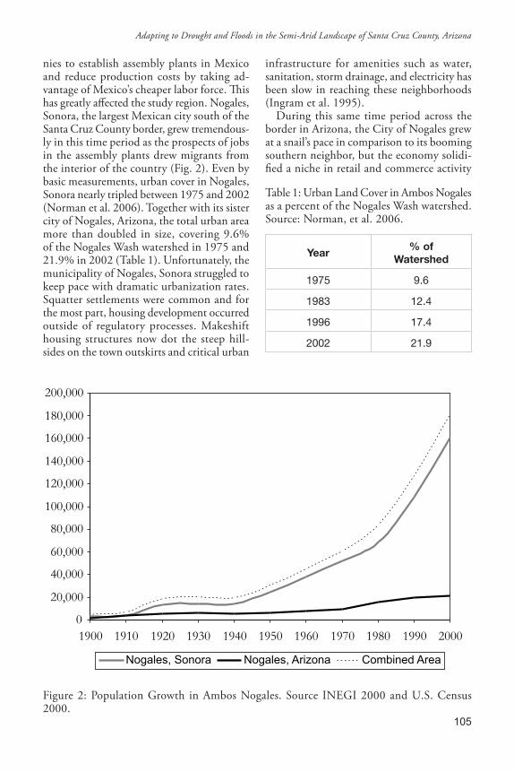
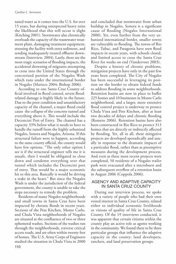
nies to establish assembly plants in Mexico and reduce production costs by taking ad-vantage of Mexico’s cheaper labor force . This has greatly affected the study region . Nogales, Sonora, the largest Mexican city south of the Santa Cruz County border, grew tremendous-ly in this time period as the prospects of jobs in the assembly plants drew migrants from the interior of the country (Fig . 2) . Even by basic measurements, urban cover in Nogales, Sonora nearly tripled between 1975 and 2002 (Norman et al . 2006) . Together with its sister city of Nogales, Arizona, the total urban area more than doubled in size, covering 9 .6% of the Nogales Wash watershed in 1975 and 21 .9% in 2002 (Table 1) . Unfortunately, the municipality of Nogales, Sonora struggled to keep pace with dramatic urbanization rates . Squatter settlements were common and for the most part, housing development occurred outside of regulatory processes . Makeshift housing structures now dot the steep hill-sides on the town outskirts and critical urban
infrastructure for amenities such as water, sanitation, storm drainage, and electricity has been slow in reaching these neighborhoods (Ingram et al . 1995) .
During this same time period across the border in Arizona, the City of Nogales grew at a snail’s pace in comparison to its booming southern neighbor, but the economy solidi-fied a niche in retail and commerce activity
Table 1: Urban Land Cover in Ambos Nogales as a percent of the Nogales Wash watershed . Source: Norman, et al . 2006 .
Year% of
Watershed
1975 9.6
1983 12.4
1996 17.4
2002 21.9
0
20,000
40,000
60,000
80,000
100,000
120,000
140,000
160,000
180,000
200,000
1900 1910 1920 1930 1940 1950 1960 1970 1980 1990 2000
Nogales, Sonora Nogales, Arizona Combined Area
Figure 2: Population Growth in Ambos Nogales . Source INEGI 2000 and U .S . Census 2000 .
Adapting to Drought and Floods in the Semi-Arid Landscape of Santa Cruz County, Arizona
106
related to transborder consumption, trans-portation, and port of entry activities, all of which increased the economic interdepen-dency of the transborder Nogales . Though significantly smaller in size, the Arizona side felt the environmental impacts of border ur-banization as well . Increased water demand on the Sonora side drew concern about water supply in the transborder basin while maquila industrial demands in particular increased the wastewater effluent flowing north to be treated . Urbanization reduced the areas of porous surfaces for basin recharge, funnel-ing runoff during storm periods . Untreated sewage easily slipped into the Nogales Wash as it flowed north during rainy periods and compromised water quality (IBWC 2001) . Air pollution from increased traffic flows and unpaved roads hovered in the air, producing an estimated 8,896 tons of pollution per year and on many days exceeding official stan-dards (BECC 2004) .
Just north of Nogales, Arizona, a second corridor of urban growth within Santa Cruz County emerged along the floodplain of the Santa Cruz River as it heads north . Here, retirement communities, second homes, and subdivisions fill in unoccupied floodplain land and are also becoming more prevalent on former ranch lands and other large estate holdings that originally date back to colonial times . The growth is largely characterized by two processes, both of which hold con-sequences for water resource management and storm drainage . First, large-scale devel-opments and subdivisions have proliferated in the county, adding to its growth . Nine new Census Designated Places appeared in the 2000 census that were not recorded in the 1990 census, while Rio Rico alone grew tenfold, from 1,407 to 10,413 in the same time period (U .S . Census 2000) . In 2000, more than 20% of the residents of Rio Rico had moved there from out of state within the previous five years . Since 2000, Santa Cruz County has experienced between 6% and 8% population growth per year, with the unincorporated communities of Rio Rico, Tubac, and Patagonia accommodating most of the new upscale subdivisions .
Second, growth in the county is charac-terized by an under-regulated development process . In 1994, the Arizona state Legisla-ture, pressured by rural interest groups and farmers, passed a bill stating that subdivision regulations were not required on lots split five times or fewer . In such cases land own-ers could subdivide their properties and sell off portions without providing any urban amenities, including roads, water and sewage infrastructure, proper drainage, and energy . While the legislation was aimed at supporting rural citizens who wished to subdivide their land, or smaller development schemes, the weakening of regulation has led to a surge in “wildcat” subdivisions in Santa Cruz County where new residents on these developments are responsible for obtaining their own utili-ties and infrastructure . These residents are often located far from current water com-pany and sewage lines and rely on individual wells that are not regulated for their water supply, yet are located predominately in the floodplain on the Young Alluvium . They also commonly use septic tanks for sewage management which are also unregulated and run the risk of polluting local groundwater resources . Lastly, these wildcat developments do not require proper drainage assessments .
mETHOdSIn this context, we attempted to determine
the interplay between structural forces and agency in shaping the ability of the residents to adapt to drought and flood . A total of nineteen interviews were conducted over a 3 ½-week period during the summer of 2004 . Those interviewed consisted of a mix of county level officials, conservation advocates, developers, ranchers, and pub-lic land managers, and lasted between one and two hours . The interviews consisted of open-ended questions to obtain perceptions of climate related hazards and impacts, as well as perceptions of current and historical adaptations in the region . Interviews were transcribed and a text analysis was conducted based on grounded theory to derive larger meaningful themes from specific interview content (See Sorrensen et al . 2005, this issue) .
Cynthia L. Sorrensen
107
In addition, we conducted archival work at various libraries on the University of Arizona campus, the Nogales Historical Society, and through online searches of local newspapers (in Tucson and Nogales, Arizona), to learn more about past responses and adaptations to climate related hazards .
AdAPTING TO dROUGHT IN NOGALES, ARIzONA
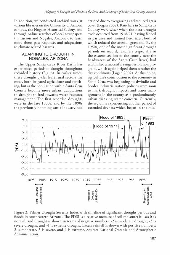
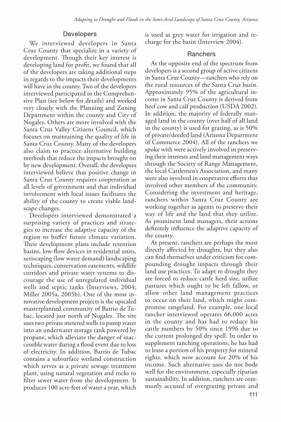
The Upper Santa Cruz River Basin has experienced periods of drought throughout recorded history (Fig . 3) . In earlier times, these drought cycles hurt rural sectors the most, both irrigated agriculture and ranch-ing, but as the population within Santa Cruz County become more urban, adaptations to drought shifted towards water resource management . The first recorded droughts were in the late 1800s, and by the 1890s the previously booming cattle industry had
crashed due to overgrazing and reduced grass cover (Logan 2002) . Ranchers in Santa Cruz County were wiser when the next drought cycle occurred from 1918-21, having fenced in pastures and limited herd sizes, both of which reduced the stress on grassland . By the 1950s, one of the most significant drought periods on record, ranchers (especially in the eastern section of the county near the headwaters of the Santa Cruz River) had established a successful range restoration pro-gram, which again helped them weather the dry conditions (Logan 2002) . At this point, agriculture’s contribution to the economy in Santa Cruz was beginning to dwindle and border industrialization policies were soon to mark drought impacts and water man-agement in the county as a predominantly urban drinking water concern . Currently, the region is experiencing another period of extended dryness which began in the mid-
-9.00
-7.00
-5.00
-3.00
-1.00
1.00
3.00
5.00
7.00
9.00
1895 1905 1915 1925 1935 1945 1955 1965 1975 1985 1995
PD
SI
Firs
t Rec
orde
d
Dro
ught
Per
iod
Pro
long
ed
Dro
ught
of 1
940s
-50s
Beg
inni
ng o
fC
urre
nt D
roug
htP
erio
d
Flood of 1977
Flood of 1983 Floodof 1993
Figure 3: Palmer Drought Severity Index with timeline of significant drought periods and floods in southeastern Arizona . The PDSI is a relative measure of soil moisture; it uses 0 as normal, and drought is shown in terms of negative numbers: -2 is moderate drought, -3 is severe drought, and -4 is extreme drought . Excess rainfall is shown with positive numbers; 2 is moderate, 3 is severe, and 4 is extreme . Source: National Oceanic and Atmospheric Administration .
Adapting to Drought and Floods in the Semi-Arid Landscape of Santa Cruz County, Arizona
108
1990s, although precipitation levels for 2004 were near normal levels and 2006 seems to be following suit .
Since the 1970s, the City of Nogales has been able to secure water resources during dry periods, but must still be relentless in meeting regulatory guidelines and insuring sustain-ability . Fortunately, the city has been able to capitalize on the region’s unique geology and hydrology and work towards a viable water harvesting system . This system was gradually assembled throughout the twentieth century to better ensure an adequate supply of water to address growth and extended dry periods (Table 2) . Water system expansion reflects an incremental adaptation process which began within the Santa Cruz floodplain and responded through time to climatic chal-lenges and population demands .
The City of Nogales began its water system in 1911 by buying a private system which
had been developed in the late 1800s to ser-vice residents on both sides of the border . It immediately expanded on this system with construction of a new well and infiltration gallery where groundwater is collected for distribution in Proto Canyon, eight miles north of the town . The system included construction of a pump and a pipeline to deliver water back to residents in town . Further extensions continued through the 1920s . By the early 1960s, however, Nogales had over-pumped the shallow aquifers near the river’s infiltration galleries, which ended the perennial flows of the Santa Cruz at that point, and the groundwater table dropped 100 feet below the loose gravel and dirt that allow quick recharge (Logan 2002) . In response, the City of Nogales looked for other water sources and acquired the surface rights to the Lake Patagonia reservoir which had been filled after completion of a dam
Table 2: Timeline of water system management in Nogales, Arizona . Source: Logan 2002 and Interviews 2004 .
Year Major Adaptation
1914 Nogales opens first pumping facility
1944 International border Water Treaty with mexico
1951 first wastewater treatment plant opens in Nogales
1962-63 Well fields put into operation north of Nogales
1965 Sonoita dam built
1972 City of Nogales purchases Potrero well field
1972 International wastewater treatment plant opens in Rio Rico
1980 Groundwater management Act passed
1990-92 City of Nogales purchases Guevavi and kino Springs well fields
1994 Santa Cruz Active management Area established after splitting from the Tucson Active management Area
1997 board of directors of the Central Arizona Project City approves Nogales proposal to sell its water rights to Scottsdale
1992-2000 Infrastructure upgrades to connect microbasins, creating water harvesting system
Cynthia L. Sorrensen
109
on Sonoita Creek . In 1972, the city began for the first time to look beyond the main floodplain of the Santa Cruz River to increase its water supply, and purchased a second well field at Portero .
The most recent major additions to the water system in Nogales have come in rela-tion to the Central Arizona Project (CAP) which delivers water to Arizona from the Colorado River (Logan 2002) . Along with the much larger and more influential cities of Phoenix and Tucson, Nogales had a right to CAP water allocations . However, the canals that distributed CAP water terminated on the southern outskirts of Tucson, approxi-mately fifty miles north of Nogales . Delivery of CAP water to Nogales, which is higher in elevation than Tucson, would require an expensive pumping system . Instead of fund-ing such a project, Nogales decided to sell its CAP water rights to the city of Scottsdale, a suburb of Phoenix . With the money received in the purchase, Nogales looked for adequate water sources closer to home and began to buy up agricultural land for its water rights . The Guevavi Ranch was the first such acquisi-tion . This allowed Nogales to disinvest in a water source project that was not feasible and reinvest in land closer to home that could be mined for water (Logan 2002) . The Guevavi Ranch was Nogales’ third well field, and was soon accompanied by the 1992 purchase of a fourth field at Kino Springs . Together the well fields are located in separate micro ba-sins . When water is pumped from one field, it does not impact the other . The system allows the city to stagger its pumping from one site to the next in order to prevent over-extrac-tion and allow for recharge .
fLOOdS, URbANIzATION, ANd AdAPTATIONS IN SANTA CRUz
COUNTyIn contrast to periodic droughts, residents
living in the Upper Santa Cruz River Ba-sin experience chronic flooding during the monsoon season as well as less-frequent but often more damaging floods coinsiding with winter rains . Over time, urban development has compounded the extent of flood damage .
As early as the turn of the twentieth century, businesses paved areas of the floodplain in Nogales and houses constructed on the surrounding hillsides were creating imper-meable surfaces . Both actions channelized water flows, which increased flood severity . Floods deemed as “significant” occurred in 1909, 1914, 1915, and 1930, with the later flood prompting federal concern and the development of the City of Nogales’ first flood control project to channelize the Nogales Wash as it crosses the international border (Logan 2002) . The story is no dif-ferent in more recent times, with the most significant regional flood events occurring in 1977, 1983, and 1993 (Fig . 3) and mon-soon flooding arising almost every year . The regional floods were extensive enough to attain disaster area status from the Federal Emergency Management Agency . Damage in all included downed electrical lines, washed out bridges, household flooding and millions in costs related to both urban and farm dam-age . The 1983 flood caused 10 fatalities in Southern Arizona region and set records for discharge and damage .
Although large floods gain national at-tention, it is normal seasonal flooding that creates chronic interruptions to everyday life: washed-out roads, collapsed embank-ments, houses filled with several feet of mud, ruptured sewer lines, damaged bridges . In addition to the physical damage, border crossing is delayed or even halted, traffic on main streets is disrupted, and economic activity in central business areas is shut down . Pollution is another major concern . With many residences on the Sonoran side still not connected to the sewage system, waste from these areas flows into the Nogales Wash during heavy rains, along with trash, debris, and sediment . Measurements of fecal coli-form counts from human waste in the flows have exceeded both Mexican and American standards for drinking water sources (IBWC 2001) . After floodwaters recede, pollution remains in sediments or is uplifted as dust into the air, causing respiratory problems (IWBC 2004) . The International Boundary Water Commission has occasionally chlori-
Adapting to Drought and Floods in the Semi-Arid Landscape of Santa Cruz County, Arizona
110
nated water as it comes into the U .S . for over 15 years, but during unexpected heavy rains the likelihood that this will occur is slight (Kitching 2001) . Stormwater also chronically overloads the capacity of the wastewater treat-ment plant, damaging treatment equipment, stressing the facility with extra sediment, and sending inadequately treated effluent down-stream (Interview, 2004) . Lastly, there are the most tragic scenarios of flooding impacts, the accidental drowning of migrants attempting to cross into the United States through the concretized portion of the Nogales Wash which runs under the international border in Nogales (Marizco 2004; Bishop 2006) .
According to one Santa Cruz County of-ficial involved in flood control, severe flood-related damage is highly likely in the future . Due to the poor condition and unsatisfactory capacity of the channel, a major flood could cause the collapse of the concrete tunnel and everything above it . This would include the Deconcini Port of Entry . The channel has a capacity 33% below what it needs to have to handle the runoff from the highly urbanized Nogales, Sonora and Nogales, Arizona . If this structural failure were to happen, according to the same county official, the county would have few options . “The only other option I see is if the structural engineer tells me it is unsafe, then I would be obligated to close down and condemn everything over that tunnel which includes the Deconcini port of entry . That would be a major economic hit to this area . Basically it would be driving a stake in the heart .” But since the Nogales Wash is under the jurisdiction of the federal government, the county is unable to take the steps necessary to remedy the problem .
Residents of many Nogales neighborhoods and small towns in Santa Cruz have been impacted by chronic floods in recent years . Sections of the Pete Kitchen, Monte Carlo, and Chula Vista neighborhoods of Nogales are situated at the confluence of two or three ephemeral washes . Sections of the washes run through the neighborhoods, traverse critical access roads, and are often within twenty feet of homes . The U .S . Army Corps of Engineers studied the situation in Chula Vista in 2000
and concluded that stormwater from urban buildup in Nogales, Sonora is a significant cause of flooding (Nogales International 2000) . Yet, even further from the very ur-banized international border, smaller towns are vulnerable to flooding . The towns of Rio Rico, Tubac, and Patagonia have seen flood impacts in recent years, with schools closed, and limited access to cross the Santa Cruz River for weeks on end (Vandervoet 2003) .
Despite a history of chronic problems, mitigation projects have only in the past few years been completed . The City of Nogales has been successful in leveraging its posi-tion on the border to obtain federal funds to address flooding in some neighborhoods . Retention basins are now in place to buffer 225 homes and 10 businesses in Monte Carlo neighborhood, and a larger, more extensive flood control project is underway to protect Chula Vista and Pete Kitchen, after at least two decades of delays and chronic flooding (Romero 2006) . Retention basins have also been constructed in Rio Rico to protect 313 homes that are directly or indirectly affected by flooding . Yet, all in all, these mitigative projects are developed sporadically and usu-ally in response to the dramatic impacts of a particular flood, rather than as preemptive measures during the development process . And even as these most recent projects were completed, 50 residents of a Nogales trailer park were evacuated after a microburst and the subsequent overflow of a retention basin in August 2006 (Coppola 2006) .
AGENCy ANd AdAPTIVE CAPACITy IN SANTA CRUz COUNTy
During our interview process, we spoke with a variety of people who had their own vested interest in Santa Cruz County, related either to individual economic livelihoods or visions of quality of life in Santa Cruz County . Of the 19 interviews conducted, it was apparent that certain citizens within the county play an active role as agents working in the community . We found there to be three particular groups that influence the adaptive capacity in the county: land developers, ranchers, and land preservation groups .
Cynthia L. Sorrensen
111
developersWe interviewed developers in Santa
Cruz County that specialize in a variety of development . Though their key interest is developing land for profit, we found that all of the developers are taking additional steps in regards to the impacts their developments will have in the county . Two of the developers interviewed participated in the Comprehen-sive Plan (see below for details) and worked very closely with the Planning and Zoning Department within the county and City of Nogales . Others are more involved with the Santa Cruz Valley Citizens Council, which focuses on maintaining the quality of life in Santa Cruz County . Many of the developers also claim to practice alternative building methods that reduce the impacts brought on by new development . Overall, the developers interviewed believe that positive change in Santa Cruz County requires cooperation at all levels of government and that individual involvement with local issues facilitates the ability of the county to create viable land-scape changes .
Developers interviewed demonstrated a surprising variety of practices and strate-gies to increase the adaptive capacity of the region to buffer future climate variation . Their development plans include retention basins, low-flow devices in residential units, xeriscaping (low water demand) landscaping techniques, conservation easements, wildlife corridors and private water systems to dis-courage the use of unregulated individual wells and septic tanks (Interviews, 2004; Miller 2005a, 2005b) . One of the most in-novative development projects is the upscaled masterplanned community of Barrio de Tu-bac, located just north of Nogales . The site uses two private metered wells to pump water into an underwater storage tank powered by propane, which alleviate the danger of inac-cessible water during a flood event due to loss of electricity . In addition, Barrio de Tubac contains a subsurface wetland construction which serves as a private sewage treatment plant, using natural vegetation and rocks to filter sewer water from the development . It produces 100 acre-feet of water a year, which
is used as grey water for irrigation and re-charge for the basin (Interview 2004) .
RanchersAt the opposite end of the spectrum from
developers is a second group of active citizens in Santa Cruz County—ranchers who rely on the rural resources of the Santa Cruz basin . Approximately 95% of the agricultural in-come in Santa Cruz County is derived from beef cow and calf production (USDA 2002) . In addition, the majority of federally man-aged land in the county (over half of all land in the county) is used for grazing, as is 50% of private/deeded land (Arizona Department of Commerce 2004) . All of the ranchers we spoke with were actively involved in preserv-ing their interests and land management ways through the Society of Range Management, the local Cattlemen’s Association, and many were also involved in cooperative efforts that involved other members of the community . Considering the investment and heritage, ranchers within Santa Cruz County are working together as agents to preserve their way of life and the land that they utilize . As prominent land managers, their actions definitely influence the adaptive capacity of the county .
At present, ranchers are perhaps the most directly affected by droughts, but they also can find themselves under criticism for com-pounding drought impacts through their land use practices . To adapt to drought they are forced to reduce cattle herd size, utilize pastures which ought to be left fallow, or allow other land management practices to occur on their land, which might com-promise rangeland . For example, one local rancher interviewed operates 66,000 acres in the county and has had to reduce his cattle numbers by 50% since 1996 due to the current prolonged dry spell . In order to supplement ranching operations, he has had to lease a portion of his property for mineral rights, which now account for 20% of his income . Such alternative uses do not bode well for the environment, especially riparian sustainability . In addition, ranchers are com-monly accused of overgrazing private and
Adapting to Drought and Floods in the Semi-Arid Landscape of Santa Cruz County, Arizona
112
public lands which can increase the amount of soil erosion and runoff, both important concerns for riparian vitality . When asked about the environmental impacts of ranch-ing, this rancher admitted that grassland degradation is “a tough deal” and that no rancher wants to see it happen . He went on to say that inexperienced ranchers, including his grandfather in the 1930s, did not know enough about the landscape and effective methods of ranching to decrease the impact . He believes that nowadays, ranchers work to reduce the impact of grassland degradation by rotating livestock to enable perennials and other native grasses to grow back . He also cited the 1993 San Rafael Valley Land Trust (SRVLT) as an example of coordina-tion between conservationists and ranchers to preserve the southeastern valley of Santa Cruz County . To confront development pressures on ranch land, the Trust manages a conservation easement which enhances the adaptive capacity of the region by conserving open land with limited use .
EnvironmentalistsThree active environmentalist groups
working in Santa Cruz County also have significant impacts on the adaptive capacity of the county: the Nature Conservancy, the Friends of the Tumacacori, and Friend of the Santa Cruz River . The Nature Conservancy, an international organization dedicated to preserving plants, animals and ecosystems across the world, has 1350 acres of protected land at the Patagonia-Sonoita Creek Preserve within Santa Cruz County . The permanently flowing creek supports a rich riparian habitat and is considered to be very diverse in both plant and wildlife . The Friends of the Tuma-cacori is a local organization that is focused on preserving the Tumacacori Mountains, just west of Tubac in the central portion of the county . Their efforts are being supported by U .S . Representative Raul Grijalva, who has proposed legislation to place over 75,000 acres under Federal Wilderness Area status . This would eliminate future development and restrict any motorized vehicles to the area . Lastly, the Friends of the Santa Cruz
River is a local organization whose goal is to maintain the riparian habitat along the perennial flow of the Santa Cruz River . They seek to protect the water supply, quality, and floodplain by serving as a voice for the river and raising awareness of its biological diver-sity . Overall, these groups have a vested inter-est in conserving the resources within Santa Cruz County . Their efforts have resulted in the protection of land from future develop-ment and in significant residential support for their activities . This is seen as a positive influence on adaptive capacity because the landscape can remain in its natural form and sustain its biological diversity .
Yet, there is also debate in Santa Cruz County over the impact of conservation-ist agendas especially as they relate to land preservation and land access . When conser-vationists work to preserve land, they limit accessibility to it and through it . This is espe-cially true for wilderness areas that restrict all motorized vehicles on protected land . In our interviews some ranchers see the proposed Tumacacori Highlands Wilderness Area as a threat to their ranching operation . At this point, rancher grazing allotments lie within the proposed area and ranchers rely on roads in the area to access ranching water opera-tions . If access is denied due to the establish-ment of a Wilderness Area, ranching activities will be compromised . As one rancher put it, it will be “very difficult to adapt .” The in-ability to access roads can also pose a threat to adaptation because there is a loss of infra-structure that might be important emergency situation . Oftentimes conservation groups do not recognize the efforts taken by ranchers to manage and maintain the landscapes, and instead seek preservation .
STRUCTURE ANd AdAPTIVE CAPACITy IN SANTA CRUz COUNTy
Three primary regulatory institutions have and continue to influence adaptive processes in Santa Cruz County . Together, these enti-ties have orchestrated a variety of measures that enhance water supply and put a check on development, but none of them are specifi-cally focused on mitigating climate impacts .
Cynthia L. Sorrensen
113
As such, their actions have had somewhat mixed results in enhancing the adaptive ca-pacity of Santa Cruz County to drought and flooding, though changes have largely been more positive than negative .
The International boundary and Water Commission (IbWC) and the International Wastewater Treatment
PlantThe IBWC was established as a result
of a 1944 treaty between Mexico and the United States to address water-related issues and management between the two countries across the entire border . The IBWC operates largely in a top-down manner . Its greatest impact in Santa Cruz County was in the establishment of a multinational wastewa-ter treatment plant originally completed in 1951 . At that time, the United States and Mexico shared the expense and for reasons of cost-effectiveness, the plant was located on the U .S . side to take advantage of the downstream conditions which allow grav-ity to assist in wastewater delivery (Sakota N .D .) . At present, Nogales, Arizona pays for and maintains the sewage infrastruc-ture north of the border, while both sides, under conditions of the 1944 treaty, must pay equally for the plant’s operational cost . Seventy percent of the wastewater processed comes from Nogales, Sonora and the other thirty percent from Nogales, Arizona .
The wastewater treatment plant has en-hanced the adaptive capacity of the region by preventing enormous amounts of indus-trial sewage from being dumped into the Nogales Wash, which would contaminate groundwater and become a health menace on both sides . In addition, the treatment plant provides a second vital service . The effluent the plant produces is released into the Santa Cruz River downstream from the facility, creating a perennial stream and recharging the aquifer . This benefits downstream com-munities, ranchers and farmers in Santa Cruz County with an increase in water availability (Sprouse 2005) . Under the treaty, Mexico is entitled to its share of the effluent and would like it to recharge its own aquifers . However,
the cost of pumping treated water back uphill into Sonora is prohibitive and has prevented Nogales, Sonora from reclaiming it . There is currently much discussion in Sonora about the construction of a treatment plant and water management reserves, but in the mean-time, the added recharge buffers drought and Santa Cruz County reaps the benefit of the situation .
While the treatment plant is a product of IBWC negotiations, cooperation to address additional transboundary water concerns is not always forthright . Lack of communica-tion is common, particularly in instances when raw sewage has been dumped in the Nogales Wash (Kitching 2001) . Often the IBWC is aware of such circumstances but may not be informed of the extent and dan-ger of pollution, chose to focus its energy on water challenges elsewhere along the border, or delay passing information onto local authorities . In addition, the IBWC contains no treaty or specific agreements on stormwater, the management of which is also transboundary but unique in terms of water resource issues . This means that transborder stormwater impacts are treated on an ad hoc basis if acknowledged at all, and transbound-ary negotiations do not account for climate variability related to stormwater impacts . . Lastly, funding is continuously an issue, par-ticularly when the bureaucracies of two fed-eral governments are involved . The municipal governments commonly pick up the tab for operation costs of the wastewater treatment plant or chlorination of Nogales Wash while waiting for fiscal approval from the federal government for compensation . The alloca-tion of funds by small local governments forces other programs to be mothballed to ensure the treatment plant stays in operation . This may have negative impacts on adaptive capacity since those funds might have been used on other government programs .
Groundwater management Act and Water management
The landmark Groundwater Management Act (GMA) of 1980 set the framework for the state of Arizona’s water policy and man-
Adapting to Drought and Floods in the Semi-Arid Landscape of Santa Cruz County, Arizona
114
agement . The GMA was signed into law in response to threats from the United States federal government to withhold funding for the Central Arizona Project which Arizona desperately wanted (Jacobs and Holway 2004) . The Act has three primary goals: 1) to control severe overdraft of groundwater; 2) to provide means to allocate the state’s groundwater sources to most effectively meet the changing needs of the state; and, 3) to augment Arizona’s groundwater through wa-ter supply development . One of the first tasks under the GMA was to identify areas experi-encing extreme overdraft and organize them into Active Management Areas (AMAs) . The Santa Cruz AMA was established in 1994 to address the specific issues which the basin faced in being a transborder watershed . With the signing of the GMA, state action regard-ing water policy and water management shifted from a low-coercion, low-impact approach to a high-coercion, direct-impact one (Jacobs and Holway 2004) . The state government became the primary structural authority on water issues, therefore gaining the ability to greatly impact the adaptive ca-pacity of Arizonans to the threats of climate variation and climate related hazards .
One of the primary policies governing growth in relation to water quality and avail-ability in AMAs is the 1995 amended As-sured and Adequate Water Supply Program . The program prohibits the sale or lease of subdivided land without proof that adequate water exists to meet the proposed uses of that land for 100 years (ADWR 2000) . An official involved in planning and community devel-opment in Santa Cruz County commended the program regulation as “a wonderful tool that really makes people do a reality check and it really makes people pay attention to water” (Interview, 2004) .
Despite the well-planned measures of the GMA, water projections remain somewhat ambiguous in the Santa Cruz AMA and the Act does not directly address the effects of long-term climate variability that would exacerbate drought and water projections are often ambiguous . First, the amount of groundwater tied up in grandfathered rights
exceeds the amount of water that is actually being recharged thus more “paper water” exists than does actual water (Carter and Morehouse 2003) . In addition, water use projections in Santa Cruz County do not fac-tor in drought (Carter and Morehouse 2003) . Satisfying the 100-year assured water supply requirement is based on historical trends in rainfall and population growth, not predicted future trends (Carter and Morehouse 2003) . Population growth projections for Santa Cruz County, like the water and climate projections, are also potentially misleading and incomplete . Some of the fastest grow-ing places in the county, such as Rio Rico have already exceeded their predicted 2015 growth . Lastly, budget cuts have made im-plementation and enforcement of the water policies and conservation measures difficult . In general, the proactive AMA approach to water management laid the framework to allow for more sustainable water manage-ment, but shortsighted understatements of climatic effects and population growth give a false sense of security, and hinder the county’s ability to maneuver and adapt in the face of future climate variation .
Santa Cruz County and the Comprehensive Plan
The third regulatory influence in Santa Cruz County which impacts adaptive capac-ity is the county’s new Comprehensive Plan . Designed as a guide for growth and develop-ment for the next ten years, the Plan was adopted by the Santa Cruz County Board of Supervisors in 2004 . The plan attempts to balance future land development with the economic goals of the county, its infra-structure needs, and its desire for resource conservation and preservation . Although is has not had an immediate influence on the community, it will have a significant impact on land use and land cover change and adap-tive strategies toward climate variation in future years .
If adhered to, four of the Plan’s goals have direct implications for the region’s adap-tive capacity to climate change, especially in respect to drought and flooding . These
Cynthia L. Sorrensen
115
goals are: the preservation and conservation of open space (Goal 2), the preservation of the Santa Cruz River and its tributaries as a ‘living river’ ecosystem (Goal 8), the protec-tion and conservation of water supplies in general (Goal 19), and the consideration of natural and human caused disasters in land use designs and planning (Goal 12) (Santa Cruz County 2004) . The first three goals re-late directly to water resources . They mandate the creation of open space and riparian ease-ments, which increase permeable surfaces and reduce erosion and runoff along waterways and also facilitate groundwater recharge at higher elevations of the watershed . In addi-tion, to uphold these goals, Plan strategies specifically seek participation from all major land managers in the county including the Arizona State and National Parks systems, the National Forest Service, the Bureau of Land Management, local advocacy groups, and private developers . This opens dialogue and communication . The fourth goal mentioned above relates directly to climate related haz-ards and explicitly mandates that adaptive strategies be upheld in further development schemes .
The influence that the Plan will have on the county and its ability to adapt to future climate variation can not fully be assessed, but some members of the community have questioned its efficacy . For example, one interviewee claimed that county supervi-sors appointed four “No Growthers” to the Planning and Zoning Board and believed it was a very idealistic approach to planning future growth in the county . Nonetheless, he did remain optimistic and believed the Plan would work with time .
EVALUATING fUTURE AdAPTATIONSince water and land resource manage-
ment plays a particularly important role in buffering potential climate impacts, structure and agency have and will continue to play a critical role in the county’s capacity to adapt . Santa Cruz County is already equipped with strong institutions to manage resources wisely and proactively; however, barriers and chal-lenges still exist in relation to future flood
events and dramatic population growth . In analyzing the roles, attitudes, interactions and policies brought about by structure and agency, it is apparent that adaptation is a complicated process .
While it is clearly apparent that many in-dividuals within Santa Cruz County partici-pate in local resource and land management decision making, it is equally apparent that these interests do not always align and for the most part they are not exclusively focused on climate change issues . This is not to say that their priorities will not overlap with climate change concerns . Indeed the underlying conservation propensities exhibited in the comments of all those interviewed tend to support the region in its adaptive capacity . At present developers seem to demonstrate a conscientious approach by applying conser-vation ideas to development plans . Of course their development schemes also facilitate much of the population growth in the area, which has already been an expressed concern in relation to water management . Developers also apply pressure to ranch landholders, who in the face of diminishing cattle operations may sell out to subdivisions . Open rangeland land would arguable facilitate the region’s adaptability more so than the impermeable surfaces of developments, thus the conserva-tion strategies of developers will only go so far . Ranchers are perhaps the interest group situated in the middle, at times having good working relations with environmentalists on maintaining open spaces and at other times, concerned about environmental enclosures which may limit their access and compromise their livelihoods . They are also the interest group that experiences climate related im-pacts the most and thus, if possible, consider at least short range climate issues in their management decisions . Lastly, environmen-talists in Santa Cruz County continue to press for conservation and serves as the county’s best check to sustain an environment that can buffer climate related impacts .
While the influences of major forces of agency in the county are complicated, the structural frameworks in place have without a doubt facilitated the adaptive capacity of
Adapting to Drought and Floods in the Semi-Arid Landscape of Santa Cruz County, Arizona
116
the county, though challenges still remain . The IBWC and the International Wastewater Treatment Plant will continue to maintain an integral role in shaping adaptive capacity because it is responsibility for setting policy to deal with trans-border water management . It will continue to abate the threat of water contamination on both sides of the border, and also alleviate groundwater overdraft pressures by restoring effluent as a source for recharge and irrigation . Yet, if urbanization in Nogales, Sonora persists and adequate in-frastructure to withstand a major flood event is not addressed, the efficiency of treatment plant will continue to be compromised . In addition, the ever pervasive uncertainty exists as to whether or not Mexico will eventually exercise its right to reclaim its allotment of effluent from the treatment plant, the loss of which would impact the upstream Santa Cruz communities . The Groundwater Man-agement Act has laid the framework necessary for water resource management However, to be successful, it must more accurately project population growth, and it must take into account more reliable projections of fu-ture climate variation, including long-term drought . Lastly, the Comprehensive Plan is the foundation for future growth and land use, if followed and enforced, promises to be another proactive stance towards adapting to future climate variation .
Lastly, while our general discussion of structure and agency paints a rather positive picture, we maintain that Santa Cruz County needs to raise awareness of climate change is-sues and potential climate impacts among the general public . This is a difficult process in a region as topographically and socio-economi-cally diverse as Santa Cruz County but giving residents an accurate portrayal of the risks related to climate is vital . Communication, then, is imperative for adaptive measures to take place . Although this part of the process is where controversy and volatility exist, overall it should be construed as a positive building block of effective adaptation . Often different institutions and agencies refuse to communicate or negate the necessity to do so . This is especially challenging in a border
county such as Santa Cruz, where the lay-ers of political involvement reach from the local to bi-national . Furthermore, ongoing participation itself is critical . Stakeholders within both structure and agency, from the federal government to the common citizen, should be strongly encouraged to be involved in community development .
CONCLUSIONSanta Cruz County currently exists in a
state of transition . As the population of the county rapidly increases and the socioeco-nomic characteristics of the area change, demands on land and water resources will also increase . But the complicated character of natural resources and politics in Santa Cruz County makes a prediction of how adaptation to climate will unfold difficult . Will evidence pointing to future climate variation be accepted and planned for ac-cordingly? Will conflicts amongst the various interests hinder adaptation? What will the true impacts of growth and land use change be? The answers to these questions will be a compilation of past, present and future ac-tions . Both structure and agency have been shown to play an integral role in adapting to climate-related hazards, and both will no doubt continue to be vital .
But although positive steps have been taken by both forces of structure and agency to protect water resources, the lack of com-mitment to develop strategies due to lack of knowledge of climate variation and lack of funding and resources indicates that adapt-ing to climate change is not a specific focus of government institutions, and it is also largely disregarded by the forces of agency . Extensive research on climate projections that accurately portray future variation must be conducted and subsequently provided to decision makers so that they can be taken into consideration . Attitudes and perceptions on future climate variation diverge widely, with the majority of individuals remaining unconvinced . Future research can and must play a critical role in changing these percep-tions, and in promoting the need to adjust and adapt . Once the idea of climate variation
Cynthia L. Sorrensen
117
and its impacts are addressed by politicians as well as local citizens, Santa Cruz County has a sound framework and foundation from which to work in adapting to these changes . Without a realistic view of what the future holds, however, even the best-designed adap-tive strategy will struggle .
ACkNOWLEdGEmENTSThe following paper could not have been
possible without the initial fieldwork and research by Arizona REU 2005 undergradu-ates George Sailba, Steven Eddy, and Dale Sherwood . Their original report formed the basis of the paper presented here . In addition, the author wishes to thank additional Arizona HERO personnel, Andrew Comrie and Diana Liverman, as well as the editorial efforts and patience of Steven Schnell, and the valuable and encouraging comments of the three anonymous reviewers for this paper . This material is based on work supported by the National Science Foundation and National Oceanic and Atmospheric Administration under NSF Grant No . SBE-9978052 (Brent Yarnal, Principal Investigator) . Any opinions, findings, and conclusions or recommenda-tions expressed in this material are those of the authors and do not necessarily reflect those of the National Science Foundation .
REfERENCESAdams, D . and Comrie, A . 1997 . The North
American Monsoon . Bulletin of the Ameri-can Meteorological Society, 78(10): 2197-2213 .
Adger, W .N . and Kelly, P .M . 1999 . Social Vulnerability to Climate Change and the Architecture of Entitlements . Mitiga-tion and Adaptation Strategies for Global Change, 4: 253-266 .
Arizona Department of Commerce, 2004 . Profile: Santa Cruz County, Arizona . www .azcommerce .com .
Arizona Department of Water Resources (ADWR), 2004 . www .azwater .gov .
Bishop, J . 2006 . Flooded Wash Proves Dead-ly . Nogales International, August 1 .
Blaikie, P ., Cannon, T ., Davis, I ., and Wis-ner, B . 1994 . At Risk: Natural Hazards,
People’s Vulnerability, and Disasters . New York: Routledge .
Border Environment Cooperation Commis-sion (BECC), 2004 . Air Quality Improve-ment for Nogales, Sonora . www .cocef .org .
Carter, R ., and Morehouse, B . 2003 . Climate and Urban Water Providers in Arizona: An Analysis of Vulnerability Perceptions and Cli-mate Information, CLIMAS Report Series, CL1-03 . Tucson, AZ: Climate Assessment for the Southwest .
Coppola, M . 2006 . Flood Water Retention Pond West of Mi Casa Trailer Park, Nogales International, August 8, 2006 .
Cutter, S . 2004 . American Hazardscapes: the Regionalization of Hazards and Disasters . Washington, DC: Joseph Henry Press .
Finan, T ., West, C ., Austin, D . and McGuire, T . 2002 . Processes of Adaptation to Cli-mate Variability: A Case Study from the US Southwest . Climate Research, 21(3): 299-310 .
Ingram, H ., Laney, M ., and Gillilan, D . 1995 . Divided Waters: Bridging the U.S.-Mexico Border . Tucson, AZ: University of Arizona Press .
Instituto Nacional de Estadistica Geografía e Informática (INEGI), 2000 . General Population Census Statistics, 1900-2000 .
International Boundary and Water Com-mission, 2001 . Binational Nogales Wash United States/Mexico Groundwater Moni-toring Program, Final Report . El Paso, TX: International Boundary and Water Com-mission .
International Boundary and Water Commis-sion, 2004 . Air Quality Improvement for Nogales, Sonora . http://www .ibwc .state .gov .
Jacobs, K .L . and Holway, J .M . (2004) . Managing for Sustainability in an Arid Climate: Lessons Learned From 20 Years of Groundwater Management in Arizona . Hydrogeology Journal, 12(1): 52-65 .
Kasperson, J . and Kasperson, R . 2001 . Global Environmental Risk . New York: United Na-tions University Press .
Kitching, H . 2001 . Chlorination of Wash on Hold . Nogales International, January 15th .
Adapting to Drought and Floods in the Semi-Arid Landscape of Santa Cruz County, Arizona
118
Logan, M . 2002 . The Lessening Stream: An Environmental History of the Santa Cruz River . Tucson, AZ: University of Arizona Press .
Marizco, M . 2004 . Mom Dies as Flood Sweeps up 7 Crossers . Arizona Daily Star, July 28th .
McCarthy, J .J ., Canziani, O .F ., Leary, N .A ., Dokken, D .J . and White, K .S . (eds .) 2001 . Climate Change 2001: Impacts, Adaptation, and Vulnerability . Published for the Inter-governmental Panel on Climate Change . Cambridge: Cambridge University Press .
Miller, J .B ., 2005a . Patagonia Could get 198 New Houses, Nogales International, October 25th .
Miller, J .B ., 2005b . P & Z gets Plan for New Housing Boost, Nogales International, No-vember 5th .
Nogales International, 2000 . Chula Vista Flood Project Approved, Dec 19th .
Norman, L ., Donelson, A ., Pfeifer, E ., and Lam, A . 2006 . Colonial Development and Land Use Change in Ambos Nogales, United States - Mexican Border, USGS Open-File Report 2006-1112 . [http://pubs .usgs .gov/of/2006/1112/of2006-1112 .pdf ] .
Romero, G. 2006. Groundbreaking Planned April 13 for Chula Vista, Nogales Interna-tional, April 10th.
Santa Cruz Active Management Area (SCA-MA), 1999 . Third Management Plan for Santa Cruz Active Management Area. 2000-2010 . Phoenix, AZ: Arizona Department of Water Resources .
Santa Cruz County Government, Arizona, 2002 . Santa Cruz County Emergency Re-sponse and Recover Plan. Santa Cruz Coun-ty, AZ: Santa Cruz Board of Supervisors .
Santa Cruz County Government, Arizona, 2004 . Santa Cruz County 2004 Compre-hensive Plan. Santa Cruz County, AZ: Santa Cruz Board of Supervisors .
Sheppard, P .R ., Comrie, A .C ., Packin, G .D ., Angersbach, K ., and Hughes, M .K . 2002 . The Climate of the US Southwest . Climate Research 21: 219-238 .
Sokota, P . N .D . Ambos Nogales on the Border: A Chronology. Tucson, AZ: The Udall Center for Studies in Public Policy, University of Arizona .
Sonoran Institute . N .D . Sonoran Institute Case Studies. San Rafael Valley Land Trust. [http://www .sonoran .org/resources/cas-estudies/si_case_sanrafael .html] .
Sorrensen, C ., Polsky, C ., and Neff, R . 2006 . The HERO REU Experience: Undergrad-uate Research on Vulnerability to Climate Change in Local Place . Geographical Bul-letin 47(2): 65-72 .
Sprouse, T . 2005 . Water Issues on the Arizona – Mexico Border: the Santa Cruz, San Pedro, and Colorado Rivers. Tucson, AZ: Water Resource Center, University of Arizona .
United States Bureau of the Census, 2000 . General Population Statistics, 1900-2000 .
United States Department of Agriculture (USDA), 2002 . Agricultural Census, www .nass .usda .gov .
Vandervoet, K . 2003 . Flood of 1983 Remem-bered this Week, Nogales International, October 9h .
Watson, R ., Zinyowera, M ., and Moss, R ., 1998 . The Regional Impacts of Climate Change: An Assessment of Vulnerability. 1997 . A Special Report of the IPCC Work-ing Group II . Cambridge: Cambridge University Press .
Cynthia L. Sorrensen