active-passive instrument package definition for advanced earth resources monitoring e....
TRANSCRIPT

Active-Passive Instrument Package Definition for Advanced Earth Resources Monitoring
E. Armandillo(*), Optics Consultant, The NetherlandsV. Kostopoulos, Climatologist, Athena SPU, Greece
(*) work carried out during ESA Contract

Presentation outline
1. New objectives in Earth remote sensing observations
2. Science/Applications needs to fulfil new Objectives
3. Needs x Advanced Instrumentation
4. Active/passive instrument package definition
5. Implementation scenario
6. Outlook and conclusions

VegetEaatritoh nObservation Programmes at ESA, J.-L.
Bézy
European Space Agency
The 5 poles of Earth Observation
OCEANS Oceans colour Surface wind Surface temperature Waves height and spectra Oceans topography
Geo
sphe
re
SOLIDE EARTH Magnetic measurements Gravity measurements
ATMOSPHERE Aerosols Atmospheric water vapour Atmospheric temperature Atmospheric winds Cloud: particles properties and profile Cloud: type, coverage and top temperature Liquid water and precipitation rate Ozone Radiation balance Trace gas (greenhouse gas, …)
SNOW and ICE Topography of frozen surface Snow coverage and thickness Ice coverage and thickness
Biosphere
LAND SURFACES Albedo and reflectance Land topography Surface temperature and humidity
VIII WLMA Slide 3

New Objectives in Earth Remote sensing observations for > 21st Century (1)
Mononitor, study and understand the synergy and interactions of the various Earth components is key for preserving resources and predict major changes: The latest update of the EO strategy put emphasis on Climate changes and the associated weather and Climate singularities and disasters that have been occurring with increasing frequency over the recent years. Specifically the new EO strategy identifies 5 key issues to which a global Earth Observation program implementation and system monitoring has to answer.

New Objectives in Earth Remote sensing observations for > 21st Century (2)
Key Issues to be addressed/understood for the > 21st Century are:
a. Food and water
b. Natural resources and energy
c. Disasters
d. Health and pollution
e. Bio-diversity conservation and protection
An observing system has to ensure continuous Monitoring of above issues to assess the effects on microclimate scales and allow for planning adaptation of resources (energy, food…etc).

New Objectives in Earth Remote sensing observations for > 21st Century (3)
These new objectives are expected to be implemented/achieved through the Earth Explorers: the ones already flying (GOCE, SMOS, Cryosat and Swarm) or to be flown (ADM and EarthCare); the newly selected 7th Explorer: Biomass, the six new Sentinels ( the first, S1A flown in 2014), the new generation of METOP, to be flown after 2020, and the new Eumetsat Polar Platforms. Analysis and assessment of the these revised observation objectives translate directly into advance observation platforms and instrumentations. On line with these new requirements and objectives here we propose a
Advanced Instrument package capable to address the majority of the new observation needs

The Background: ESA EO Mission Scenario

The Background: The GCOS Scenario
The vision of GCOS: an integrated global system of ground-based, airborne and space- based components providing comprehensive information about the global climate system (Credit: GCOS, 2007)

The New Observation requirements for Atmosphere
To meet the advanced observation requirements, needs have been identified for :
advanced imagery,
advanced spectrometry,
advanced radiometry,
in terms of spectral and spatial resolution, larger FOV telescope,
new and advanced lidar instrumentation:multi-frequency , multi-spectral bands with high resolution.
Also is being stressed the improved Data fusion among passive and active instruments . And for the first time IS BEING recognized the importance of Mesosphere observations as a key to study the link with the Biosphere and Climate change due to variation in Solar activity, Space weather and its influence with the Atmosphere dynamics.

The Mesosphere Observations from Space
A mesospheric lidar concept “ GLEME”, was reported(*) @ the Boulder 25ILRC (S08P-12 GLEME: Global lidar exploration of the mesosphere --- E. R. Talaat, T. E. Sarris, A. Papayannis, E. Armandillo, X. Chu, M. Daly, P. Dietrich, V. Antakis). The mission concept in GLEME, was studied and proposed in order to obtain temperature and horizontal winds in the mesosphere with the highest ever spatial and temporal resolution, allowing the determination of gravity wave characteristics, heat and momentum wave flux, and their effects on the low lying atmosphere. The motivation behind this concept is that:
the mesosphere remains an under-sampled region with many open questions. This region is the “gateway” that connects Earth’s environment with space, and is a region of great importance in energy balance processes and a link in vertical energy transfer down to the troposphere and therefore is very important not only for solid Earth physics but also for Climatology and Environmental sciences.
(*) See also: P. Verronen, E. Armandillo et al: “Contribution of proton and electron precipitation to the observed electron concentration in October-November 2003 and September 2005”, to be published in “Annales-Geophysicae”, 2015

New elements for Biosphere Observations
1. For Biosphere, further to improved Optical Imagery and Radiometry the use of Lidar for Vegetation and Canopy will add an important element in the study and understanding of Biosphere evolution and conservation.
2. Early work on sensor fusions (lidar/imager) was already shown/reported at VII WLMA
3. For Space, a Vegetation missions has now approved @ NASA: GEDI (Global Ecosystem Dynamics Investigations) for implementation on then ISS (GEDI will use E. Armandillo Tx concept published in Optics Letter in 1995).Scheduled for the ISS in 2019, will create a variety of products: canopy height and structure, forest carbon and carbon change. Further, such data will be used in ecosystem models to assess the impacts of changes in land use on atmospheric carbon under various climate change scenarios (Ref. Barry Coyle, NASA Goddard).

What is expected by combination of Active /Passive sensors
An Instrument package: named HSRInP (High Spectral resolution Instrument Package), comprising and Active HSRL (High Spectral Resolution Lidar) and Passive HSRIm(High Spectral Resolution Imager) can contribute to all the new-updated Themes as identified in the ESA EO Strategy (under finalization):
The heritage of early combination can be seen in Earth Explorer 6 (Earth Care), and today in the Earth Explorer 8 (Flex)
EE8 selection: Flex or Carbonsat ? October 2015, following the User’s consultation meeting in Poland
Already Lidar/Imager Combination x FLEX reported @ VII WLMA in Chile

Contextual Missions: The Earth Explorer 6: Earth Care

Heritage missions: Earth Care Payload

Biosphere relevant missions: The EE8: CarbonSat
1. Earth Explorer 8 missions (EE8, selected in 2010) under investigations are: Flex and CarbonSat are in Phase A/B1. Both FLEX and CarbonSat aim to provide key information on different aspects of the carbon cycle.
2. The CarbonSat mission would quantify and monitor the distribution of two of the most important greenhouse gases in the atmosphere, also released through human activity: carbon dioxide and methane. Data from the mission would lead to a better understanding of the sources and sinks of these two gases and how they are linked to climate change.
Biosphere relevant missions: The EE8: FLEX
The FLEX mission aims to provide global maps of vegetation fluorescence, which can be converted into an indicator of photosynthetic activity. These data would improve our understanding of how much carbon is stored in plants and their role in the carbon and water cycles. The mission would work in combination with the Ocean and Land Color Instrument and the Sea and Land Surface Temperature Radiometer on Sentinel-3 to improve models of future atmospheric carbon dioxide concentrations.

Instrument Package Definition: the HSRIm
The High Spectral resolution Imager is built upon a
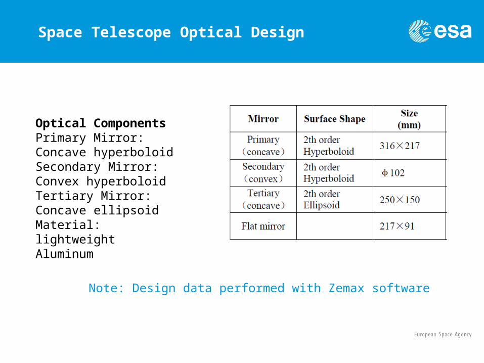
1. Korsch TMA (additional Optics required for the Space version) : a compact optical non-scanning (staring) telescope, (Triple Mirror Anastigmat) to keep optical distortion to a minimum:
a. Spherical
b. Chomatic
c. Astigmatism
2. Offner Spectrometer (this spectrometer is made up of three spherical and concentric surfaces: two concave mirrors and a classical convex grating. This system can be easily designed and optimized with ZEMAX or more simpler with the free available version of OSLO design software
3. Detection & Signal electronics
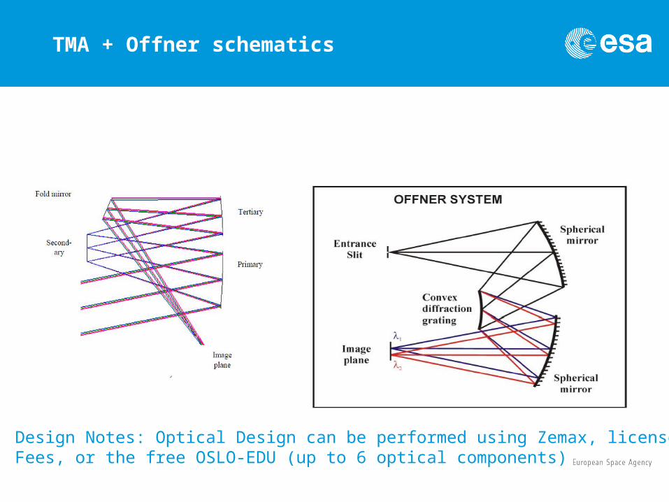
TMA + Offner schematics
Design Notes: Optical Design can be performed using Zemax, licensed Fees, or the free OSLO-EDU (up to 6 optical components)
Space Telescope Optical Design
Optical ComponentsPrimary Mirror: Concave hyperboloidSecondary Mirror: Convex hyperboloidTertiary Mirror: Concave ellipsoidMaterial: lightweight Aluminum
Note: Design data performed with Zemax software

Proposed HSR Detector Package
Imager detector arrays : in Si-CMOS technology (highest ratio perfo. to cost) x visible, UV, InGaAs x NIr/SWIr
Focal Plane: SWIR and NIR bands: say 3 VNIR (bands centered at 460, 658, 834 nm) and 1 SWIR (band centered @1609 nm):
a. VNIR: 4 x linear Array of > 6000 pixel of 12 micron size
b. SWIR: n x 1024 linear array
c. Vis, UV: 2-D array
At longer wavelengths: Quantum detector (x speed): extrinsic-type (eg Ge-based or Si-based,but they need ultra-cooling !) or MCT (up to 15-20 micron)

Instrument Package Definition: the HSRL
The High Spectral resolution Lidar is built upon a Nd:YAG laser up-converted to 2nd and 3rd harmonic, in combination with an OPO + OPA combination (Optical Parametric Oscillator and Amplifier) to access the required wavelength bands. The OPO (Optical Parametric Oscillator) selected x can provide, by nonlinear mixing, a vast choice of wavelengths as required by the applications.
OPO concept:
Kp= Ks+ Ki

Outline Specifications of HSRL
HSRL Lidar preliminary specifications (*):
Output energy:
Pump: 100 mJ class @ fundamental Yag @ 10 Hz
Signal: 1-10’s mJ from 0.350 µ to 4 µ possible with different non-linear materials,
OPO + OPA Configuration
Telescope: 30 cm class
FOV: 1 mrad (*)
Focal Plane: Si APD (Vis, UV)or InGaAs APD (NIR, SWIR),
(*) Detailed Specifications will change according to Ground/Space applications

Use Heritage from Recent Advances in OPO/OPA technology
Credit: Onera, ICSO2014

Example of recent OPO/OPA Lidar Concept
Credit: Lidar Technologies, Techniques, and Measurements for Atmospheric Remote Sensing IX, edited by U.N. Singh, G.Pappalardo

Some info on OPO materials and Accessible Spectral bands
1. The Domain of OPO NLC is a vast and still expanding for wavelength up/down conversions
2. Still a lot of optimization work is needed to identify the best OPO materials x the coverage of the required spectral bands, as needed for the Biosphere observations
3. Rule of thumbs:
a) UV to Visible : from LBO
b) From deep red to 3 micron: KTP
c) From to to 20 micron: Chalco-pyrites (AgGaSe2, GaSe, etc)

Instrument Package Definition: some proposed HSRInP shared channels
Some Important vegetation/Canopy Channels (μm ) and Bandwidth (nm) to be observed by the HSRIm:
0.55 / 20 nm Chlorophyll
0.66 /20 nm Vegetation Index
0.87 /20 nm Vegetation Index, and also needed
1.6 /0.3 μm Cloud Clearing
3.7 / 0.3 μm Sea Surface Temperature
11/ 1.0 μm Sea Surface Temperature
12 / 1.0 μm Sea Surface Temperature

Conclusions and outlook
1. The design principles for a HSR instrument package consisting of an HSRL and HSRIm have been given: this Instrument package is ambitious in the development effort, cost and performance, but can provide very valuable information for the Earth Biosphere resources monitoring and planning, as well as, with proper design, address the other objectives set for ESA new 21st century EO long term plan
2. This package can be utilized both on ground (outline design specifications given) or Space
3. By suitable choice of Bands, this instrument suite can be applied to cover a wide range of observation requirements in Earth as well as Planet science.
For further info or contact;