acid sulfate soil survey of the shallow regolith on the ... · acid sulfate soil survey of the...
TRANSCRIPT
Acid sulfate soil survey of the shallow regolith on the Scott Coastal Plain
Hydrogeological record series Report no. HG24 March 2009
Looking after all our water needs
Government of Western AustraliaDepartment of Water

Acid sulfate soil survey of the shallow regolith on the Scott Coastal Plain
Looking after all our water needs
Hydrogeological record series
Report no. HG24
March 2009
Department of Water 168 St Georges Terrace Perth Western Australia 6000 Telephone +61 8 6364 7600 Facsimile +61 8 6364 7601 www.water.wa.gov.au
© Government of Western Australia 2009
March 2009
This work is copyright. You may download, display, print and reproduce this material in unaltered form only (retaining this notice) for your personal, non-commercial use or use within your organisation. Apart from any use as permitted under the Copyright Act 1968, all other rights are reserved. Requests and inquiries concerning reproduction and rights should be addressed to the Department of Water.
ISSN 1329-542X (print)
ISSN 1834-9188 (online)
ISBN 978-1-921549-51-9 (print) ISBN 978-1-921549-52-6 (online)
Acknowledgements
Dr Brad Degens and Penny Wallace-Bell prepared this report while working with the Land and Water Quality Branch of the Department of Environment and Conservation, with assistance from Geoff Sadgrove, Ian MacPherson, Peter Geste and Shawn Teggerth in the coring, collection of field information and processing of samples. The authors acknowledge and thank Sharon Clark, Phil Commander, Adam Lillicrap, Sandie McHugh and Ryan Vogwill who critically read the draft of this report.
For more information contact:
Dr Brad Degens Water Science Branch Department of Water (contact details above)
Recommended reference
The recommended reference for this publication is: B Degens & P Wallace-Bell P 2009, Acid sulfate soil survey of shallow regolith on the Scott Coastal Plain, Department of Water, Government of Western Australia, Hydrogeological record series, Report no. HG24.
Cover photograph
View towards Gingilup Swamps from Milyeannup Coast Road (eastern Scott coastal plain) with acid sulfate soil investigation site in foreground. Photograph by Brad Degens, April 2005.

Acid sulfate soil survey of the shallow regolith on the Scott Coastal Plain Hydrogeological record series, Report no. HG24
Department of Water iii
Contents Summary .................................................................................................................................. v
1 Introduction..........................................................................................................................1 1.1 General information...................................................................................................................1 1.2 Report context and objectives...................................................................................................2 1.3 Regional setting: geology, geomorphology and soils ...............................................................3
2 Investigation and mapping methods ....................................................................................7 2.1 Preparation of the base map.....................................................................................................7 2.2 Identification of target sites for ASS investigation.....................................................................7 2.3 Site characterisation, lithological description and ASS sampling ...........................................10 2.4 Sample handling and analysis ................................................................................................10 2.5 Data storage, quality assurance and quality control ...............................................................11 2.6 Analysis of field and laboratory data to develop ASS risk map ..............................................11
3 Results...............................................................................................................................13 3.1 Characteristics of acid sulfate soil materials on the Scott Coastal Plain ................................13 3.2 Landscape patterns and mapping ASS hazard areas ............................................................15 3.3 Estimated potential acid storage at investigation sites ...........................................................18 3.4 Existing acidity ........................................................................................................................18
4 General discussion ............................................................................................................21 4.1 Shallow regolith with potential ASS materials on the Scott Coastal Plain ..............................21 4.2 Shallow regolith with acidity due to PASS oxidation on the Scott Coastal Plain ....................22 4.3 Environmental risks posed by ASS on the Scott Coastal Plain ..............................................23 4.4 Identifying groundwater trigger levels for management of ASS materials..............................30 4.5 Implications of ASS occurrence for water quality monitoring..................................................31 4.6 Further work ............................................................................................................................34 4.7 Conclusion ..............................................................................................................................35
References .............................................................................................................................36
Appendices Appendix 1: Investigation site details .....................................................................................41
Appendix 2: DEC Contaminated Sites Branch (previously Land and Water Quality Branch) acid sulfate soil field methods............................................................................................43
Appendix 3: Classification of ASS disturbance risk................................................................49
Appendix 4: Shallow regolith description and potential ASS characteristics..........................51
Appendix 5: Groundwater decline trigger levels at core sites ................................................57
Hydrogeological record series, Report no. HG24 Acid sulfate soil survey of the shallow regolith on the Scott Coastal Plain
iv Department of Water
Figures Figure 1: Study area and location of PASS investigation sites .............................................6 Figure 2: Soil-landscape mapping units and dominant landforms for the Scott River soil
system ...................................................................................................................9 Figure 3: Map showing potential acid sulfate soil materials occurring within the shallow
regolith (<3 m) on the Scott Coastal Plain ...........................................................16 Figure 4: Estimated storage of potential acidity (expressed as tonnes H2SO4 per ha) .......19 Figure 5: Total titratable acidity (TTA equivalent kg H2SO4/tonne) in samples of
pHKCl<6.5 .............................................................................................................20
Tables Table 1 Generalised stratigraphy........................................................................................5 Table 2: Sites with acidity due to PASS oxidation .............................................................14 Table 3: Soil-landscape mapping units that identify areas of shallow PASS materials .....17 Table 4: Potential consequences of acid sulfate soil disturbance and the subsequent
generation of acidic water....................................................................................26 Table 5: Recommended water quality parameters for detecting and monitoring ASS ......32
Acid sulfate soil survey of the shallow regolith on the Scott Coastal Plain Hydrogeological record series, Report no. HG24
Department of Water v
Summary A survey of potential acid sulfate soil (PASS) materials in the shallow regolith of the Scott Coastal Plain was undertaken to broadly identify the likely spatial extent and characteristics of this natural geochemical hazard and implications for management of the shallow water table. Disturbance of the land, to the extent that shallow PASS materials are exposed, risks triggering oxidation of these materials. Potential effects of the PASS materials being exposed are difficult to predict and can range from minimal, short-term localised impacts to the worst-case scenario of long-term catchment-scale changes in biogeochemistry.
The survey identified that much of the poorly drained flats consisting of seasonal wetlands and damplands and associated low dunes and sandy rises were highly likely to be underlain by the regolith with shallow PASS materials. These areas were equivalent to approximately 530 km2 of the Scott Coastal Plain – extending throughout the plain from east of Lake Jasper to the Blackwood River/Hardy Inlet and could be mapped using existing soil-landscape map units.
Investigations of the shallow regolith at 50 sites (as a series of broad transects across the plain) identified PASS materials at 45 of these sites. Analyses indicated that shallow PASS materials frequently occurred within 1.5 m of the soil surface (though not at all sites) and generally only marginally below the estimated minimum summer watertable level. PASS materials commonly occurred in sandy horizons, with varying degrees of iron cementation and organic content. More than 30 tonnes of H2SO4/ha was commonly stored within the upper 1 m layers of PASS materials throughout the coastal plain, with several sites exceeding 150 tonnes of stored H2SO4/ha. There was evidence of significant acidity accumulating in more than 20 per cent of sites that was due to recent oxidation of PASS materials. This was particularly evident in an area north of Lake Quitjup.
The results of this survey highlight the need for further investigation into the distribution and acid-producing potential of materials at specific sites across the Scott Coastal Plain. Equally important is the need to link together the distribution of PASS materials and the potential for future watertable decline under different abstraction, climatic and land-use scenarios.
The recommendations arising from the survey are to undertake high-resolution acid sulfate soil (ASS) sampling and mapping, in conjunction with groundwater-flow modelling to produce an ASS hazard map that is based on detailed geochemical data and knowledge of hydrogeochemical and hydrogeological processes.

Hydrogeological record series, Report no. HG24 Acid sulfate soil survey of the shallow regolith on the Scott Coastal Plain
vi Department of Water
Acid sulfate soil survey of the shallow regolith on the Scott Coastal Plain Hydrogeological record series, Report no. HG24
Department of Water 1
1 Introduction
1.1 General information Acid sulfate soil (ASS) materials are any soil or sediment materials containing sulfuric acid stored or actively being released from sulfide minerals (Rabenhorst & Fanning 2002). In this context ASS materials include potential ASS (or PASS) and actual ASS (AASS) materials. PASS materials are those mineral materials containing acidity stored predominantly as microscopic grains of iron sulfides (mainly pyrite) in permanently waterlogged, frequently anoxic and submerged soil layers (Dent 1986; Sammut 2000) described as sulfidic layers (Isbell 1996). AASS materials are those materials where sulfide minerals are oxidising (or have oxidised) releasing sulfuric acidity and forming sulfuric layers (Isbell 1996).
While undisturbed and in an anoxic state, these materials pose no risk to the environment and are commonly not acidic with pH generally greater than 6.5. However, if disturbed by excavation, drainage, lowering of watertables by groundwater pumping or long-term alteration of catchment water-balance (including vegetation and climate change), air entry to the regolith causes the iron sulfides to oxidise. This oxidation releases sulfuric acid and triggers a complex array of secondary reactions and processes – all resulting in potentially widespread impacts on the environment (Dent 1986; Rabenhorst & Fanning 2002). In general terms, disturbance of PASS materials resulting in oxidation of these materials causes the formation of AASS materials and ASS-related environmental problems.
In Western Australia shallow potential acid sulfate soils (PASS) are widely distributed in areas adjacent to estuaries and many upland wetlands of the state’s south (Western Australian Planning Commission 2003). Smaller areas of PASS also can occur in association with salt and freshwater seeps in inland areas. It is increasingly becoming evident that many upland areas along the coast, particularly in the Perth basin, contain extensive areas of PASS (often not shallow) and that disturbance of these needs to be managed to avoid potentially widespread contamination of groundwater resources (Appleyard et al. 2004; Department of Environment 2004a).
Rapid recognition of the environmental threat posed by ASS spurred the implementation of planning guidelines to manage ASS in land-development processes (Western Australian Planning Commission 2003) and creation of an overarching framework for management of ASS in Western Australia (Department of Environment 2004a). In support of these strategies, in 2003 the Department of Environment (now the Department of Environment and Conservation) began to broadly identify areas of ASS risk in coastal regions of the state based on desktop compilation of information. State and local government planning authorities routinely use this information to identify where land-development proposals carry a risk of disturbing ASS materials (ASS disturbance risk) and the management response to deal with this risk (Western Australian Planning Commission 2003; Department of Environment 2004a). Development of land can involve disturbances to soils and groundwaters to install services, construction of roads and bridges and stormwater systems, installation of tidal barriers or barriers to groundwater movement, as well as larger disturbances involving construction of canals. All of these activities have the capacity to trigger oxidation of PASS materials if they are not carefully managed (in areas where these materials occur). Beyond disturbance during land development, however, ASS needs to be considered in the broader context of natural resource management since there are likely to be areas with PASS materials that do not occur near population centres and that underlie
Hydrogeological record series, Report no. HG24 Acid sulfate soil survey of the shallow regolith on the Scott Coastal Plain
2 Department of Water
rural and semi-rural land use. Local and regional management of shallow watertables may pose the greatest disturbance threat in such areas.
There is increasing recognition that declines in shallow watertables due to human and climate-induced changes in landscape water-balances are likely to result in disturbance of PASS materials across wide areas of the landscape in Western Australia, within both water scapes and shallow groundwaters (Appleyard et al. 2005). Such widespread release of acid from PASS materials has the potential to cause extensive, possibly long-term environmental damage and changes in the quality of groundwater in superficial aquifers. Changes in watertables may be linked with declining rainfall patterns over recent years, however, ongoing abstraction of groundwater and changes in catchment water-balances due to drainage or increased vegetation (e.g. tree plantations with transpiration rates exceeding natural vegetation) also increases pressures on watertable levels (Berti et al. 2004; Department of Environment 2005).
1.2 Report context and objectives For some time, there has been fragmented evidence of PASS materials occurring in the shallow regolith on the Scott Coastal Plain. Pressures to develop water resources, intensify land uses or adopt perennial cropping systems have increased the need to determine the extent and characteristics of PASS in the shallow regolith of the South West region. Development of a water allocation strategy for the South West groundwater areas has required information on the characteristics and distribution of PASS materials in the shallow regolith to determine trigger watertable levels above which disturbance of PASS materials is minimised. The South West groundwater areas range from the lower Swan Coastal Plain in the Bunbury region to the Scott Coastal Plain on the southern coast, including the Blackwood Plateau. This study focuses only on the Scott Coastal Plain (Figure 1), although shallow ASS materials also occur around the estuaries and wetlands on the Swan Coastal Plain.
Sulfide minerals (forming the basis of potential ASS) are known to occur deep in the Leederville Formation at the BHP Beenyup Mine near the lower Scott River/Blackwood confluence and in superficial deposits adjoining the mineral sands at Capel Sands’ Jangardup Mine (north-west of Lake Jasper). There is evidence that sulfide minerals occurred in deep horizons and of the possibility that these supported formation of shallower deposits of PASS materials in the surface waterlogged regolith (termed shallow ASS). In Western Australia, products from the oxidation of deeper sulfides in geologically older deposits during previous climatic periods may have provided sources of sulfate and ferrous iron to enable formation of shallow PASS materials during the Holocene. Initial investigations of ASS in support of the South West groundwater management plan were carried out on the Scott Coastal Plain in late 2003 (Angeloni 2003) on the basis of the high environmental value of the region’s wetlands and high expectations of ASS occurring. This work established that significant shallow (<3 m) ASS could occur; however, the limited extent of investigations did not enable any conclusions to be drawn about the spatial occurrence of PASS materials.
This document presents the characteristics, distribution and management implications of shallow ASS materials on the Scott Coastal Plain as a framework for establishing the use of watertable-decline trigger levels (in the superficial aquifer) based on ASS characteristics in the South West groundwater area. The Water Allocation Planning Section of the Department of Water commissioned the report to provide:
a broad determination of the distribution of ASS on the Scott coastal plain

Acid sulfate soil survey of the shallow regolith on the Scott Coastal Plain Hydrogeological record series, Report no. HG24
Department of Water 3
an evaluation of the risk that PASS materials pose to the environment (with respect to groundwater management)
an overview of the problems that could occur if acidity were to be released from PASS materials
general recommendations for monitoring impacts of ASS.
The data for this work draws on the results of initial investigations to broadly survey PASS materials on the Scott Coastal Plain, as carried out by the Land and Water Quality Branch of the Department of Environment and Conservation (DEC) for state-wide mapping of ASS risk. Investigations conducted in this report have been described as occurring in shallow horizons in the regolith. In this context, the regolith is defined as soil, superficial formations and weathered Cretaceous and Jurassic sedimentary rocks. This terminology has been used rather than the standard geological classification because the nature of the investigations did not allow distinction between superficial formations and underlying weathered Cretaceous or Jurassic sediments (frequently thought to be encountered in the lower sections of cores).
1.3 Regional setting: geology, geomorphology and soils
Physiographic regions and regolith-landform systems
The physiographic region of the Scott Coastal Plain is bordered by three others: the Margaret River Plateau to the west, the Blackwood plateau to the north (Tille & Lantzke 1990b) and the Darling Plateau to the east Figure 1). The boundaries are marked by scarps, which are mostly well defined except along the Barlee Scarp, where the Blackwood Plateau meets the Scott Coastal Plain west of the Milyeannup Coast Road (Baddock 1995).
The Scott Coastal Plain is a low-lying strip of poorly drained, flat to gently undulating land up to 17 km wide, separated from the Southern Ocean by a narrow belt of high coastal dunes (Figure 1). The three main rivers crossing the plain are the Blackwood, Donnelly and Scott. The permanent freshwater lakes Quitjup, Jasper, Wilson and Smith are situated within the D’Entrecasteaux National Park on the eastern part of the plain. During winter, extensive wetlands develop between the coastal dunes and the scarps.
Recent regolith-landform 1:50 000 scale mapping of the western Scott Coastal Plain divides the plain into three regolith-landform (or land) systems: Quindalup System, Blackwood System and Scott System (Hall & Marnham 2002). The Quindalup System is underlain by aeolian and coastal deposits, and consists of calcareous sand, weakly lithified calcarenite and organic sandy soils. The Blackwood System is dominantly fluvial and estuarine, with tidal deposits comprising silty sands, sands and gravels. The Scott System is underlain by fluvial and coastal deposits, and consists of sands and silty sands. These systems are broadly correlated to the land systems described by Tille and Lantzke (1990a), which were described in mapping of the central and western extent of the plain.
Baxter (1977) describes the Scott Coastal Plain as being geomorphically similar to the Swan Coastal Plain. It consists of a piedmont alluvial plain with four shoreline and dune systems. The dune and shoreline deposits – Quindalup, Milyeannup, Warren and Donnelly – become progressively older inland and are equivalent to the geological formations Safety Bay Sand, Tamala Limestone, Guildford Formation and Yoganup Formation respectively. The oldest, the Donnelly Shoreline, lies at the base of the Barlee Scarp and its lateritised deposits are often dissected by streams and buried below alluvial fans. The Warren Shoreline lies north of
Hydrogeological record series, Report no. HG24 Acid sulfate soil survey of the shallow regolith on the Scott Coastal Plain
4 Department of Water
the Scott River and south of the Barlee Scarp. It consists of a series of low subdued dunes associated with swamplands. The Milyeannup Shoreline is made up of discontinuous fixed dune and beach forms (Baxter 1977) and is composed of leached sands overlying limestone. The Quindalup Shoreline is the modern active coastal dune system and consists of mobile and immobile, parabolic and deflated dunes and swales with common blowouts. The succession of shorelines and their associated dune deposits are attributed to eustatic sea-level changes caused by the intermittent expansion and contraction of the polar icecaps that occurred mostly during the Pleistocene (Hall & Marnham 2000). Sea-level changes may also have been influenced by regional tectonism (Iasky 1993).
Geology
The Scott Coastal Plain is underlain by superficial formations (Baddock 1995). They comprise alluvial, lake, swamp, estuarine and shoreline deposits unconformably overlying sediments and basalt flows of the Mesozoic or marine sediments of the Eocene. A generalised stratigraphy is provided in Table 1.
The superficial formations consist of sediments deposited during the Pliocene, Pleistocene and Holocene and have been broadly described as being similar to the superficial formations on the Swan Coastal Plain (Baddock 1995). Unlike the Swan Coastal Plain, the Yoganup Formation has not been identified in drilling (Baddock 1995) on the Scott Coastal plain. However, the equivalent lateritised Donnelly Shoreline and associated dunes lie along the base of the Barlee Scarp (Baxter 1977). These sediments are interbedded sand, conglomerate and clay. The Guildford Formation on the Scott Coastal Plain consists of fine to gravel-size, poorly to well sorted, unconsolidated quartz sand (Baddock 1995) and occurs along the Warren Shoreline. The sands can be iron cemented and of variable thickness, continuity and induration. Thin layers of peat and clay are also present. Numerous small linear dunes occur on the formation and may be equivalent to the Bassendean Sands of the Swan Coastal Plain (Baddock 1995).
Spearwood Dunes form a coastal belt of discontinuous dune and beach forms consisting of an aeolinite core of calcrete-capped calcarenite (Tamala Limestone) and overlying sands. The sands are yellow-orange to white, fine to medium and coarse grained, moderately sorted and evolved as a result of in situ weathering of the Tamala Limestone (Tapsell et al. 2003).
Mobile coastal sand dunes and shallow marine to littoral sands (Passmore 1970) form the Quindalup Dunes. They are mostly parabolic dunes and include weakly lithified dunes and swales. The sands consist of shell fragments and quartz with minor organic matter.
The superficial formations may unconformably overlie Mesozoic-aged deposits or marine deposits associated with an Eocene transgression event and consist of a thin unit of fine to very coarse grained, poorly to moderately sorted, quartz sand (Baddock 1995). The superficial formations also variably directly overlie the Leederville Formation west of Black Point and along the Darling fault and mostly overlie the Yarragadee Formation to the east of Black Point (Water Corporation 2005).
The Leederville Formation belongs to the Warnbro Group and occurs as a fluviatile and marine unit of interbedded sandstone and siltstone, with minor amounts of conglomerate, coal or lignite (Iasky 1993) deposited during the Early Cretaceous (Crostella & Backhouse 2000). The sediments generally grade upwards from a coarse basal section of largely reworked Lesueur Sandstone and Yarragadee Formation (Baddock 1995). Ferruginised sandstone and conglomerate outcrop is seen on the riverbed and banks of the Blackwood River (Hall & Marnham 2002).
Acid sulfate soil survey of the shallow regolith on the Scott Coastal Plain Hydrogeological record series, Report no. HG24
Department of Water 5
The Bunbury Basalt is a tholeiitic basalt (Burgess 1978) and unconformably overlies the Yarragadee Formation: it was probably extruded along north-trending faults during continental break up in the Early Cretaceous (Baddock 1995) and can be interpreted as occupying palaeodrainage channels in the eroded Yarragadee Formation (Iasky 1993). The Bunbury Basalt outcrops at Black Point and at the foot of the high dunes at the mouth of the Donnelly River.
The Parmelia Formation (Backhouse 1984) comprises a very Late Jurassic to very Early Cretaceous interbedded silty shale, siltstone and sandstone (Crostella & Backhouse 2000). On the Scott Coastal Plain, the Parmelia Formation is intersected in only one hole in reported drilling (Baddock 1995) – at the base of the Barlee scarp just west of the Milyeannup Coast Road. The formation has been raised to group status (Crostella & Backhouse 2000) but on the Scott Coastal Plain, no assignment to the new formation units has been made thus far.
The Yarragadee Formation (Table 1) is a Late Jurassic sandstone of fluvial origin (Backhouse 1984). It is composed of mainly fine to coarse grained, poorly sorted, feldspathic, interbedded sandstone. The sandstone is interbedded with siltstone, shale and minor conglomerate and coal representing minor overbank deposits, parts of the fluvial system, or swamps (Crostella & Backhouse 2000). The Yarragadee Formation is overlain by the Bunbury Basalt, Warnbro Group or the superficial formations (Baddock 1995).
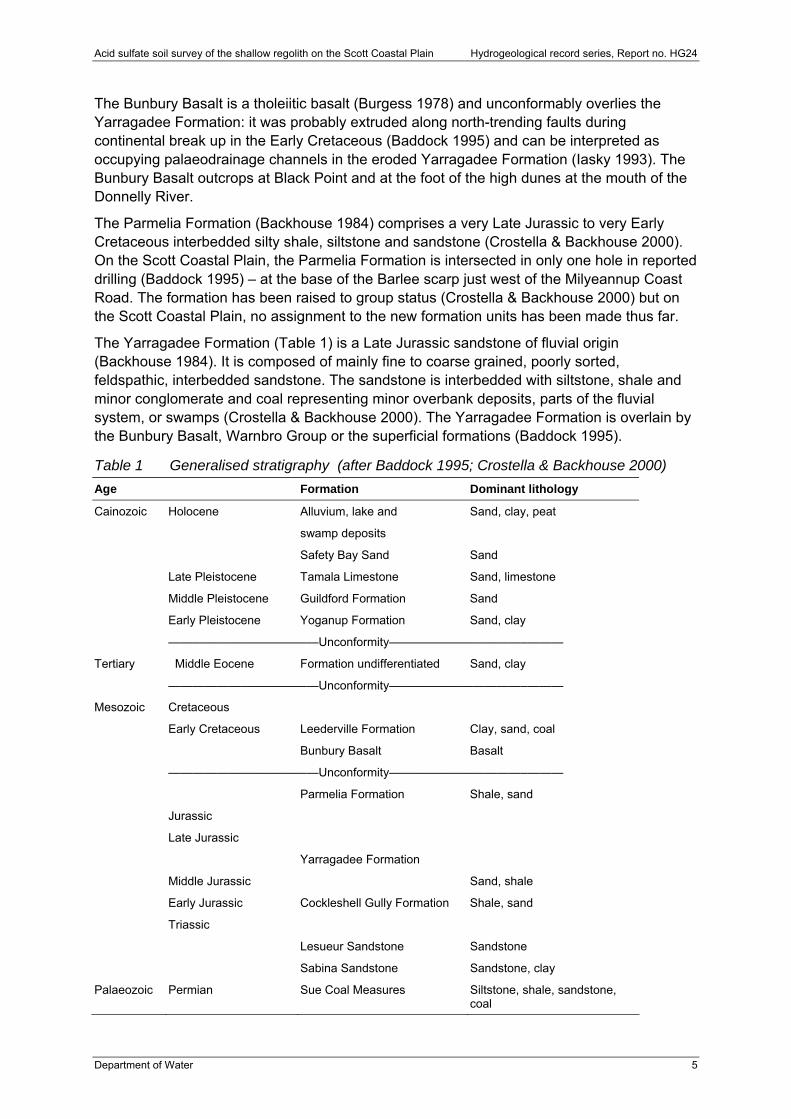
Table 1 Generalised stratigraphy (after Baddock 1995; Crostella & Backhouse 2000)
Age Formation Dominant lithology
Cainozoic Holocene
Alluvium, lake and
swamp deposits
Sand, clay, peat
Safety Bay Sand Sand
Late Pleistocene Tamala Limestone Sand, limestone
Middle Pleistocene Guildford Formation Sand
Early Pleistocene Yoganup Formation Sand, clay
———————————–—Unconformity———————————–———
Tertiary Middle Eocene Formation undifferentiated Sand, clay
———————————–—Unconformity———————————–———
Mesozoic Cretaceous
Early Cretaceous Leederville Formation Clay, sand, coal
Bunbury Basalt Basalt
———————————–—Unconformity———————————–———
Parmelia Formation Shale, sand
Jurassic
Late Jurassic
Yarragadee Formation
Middle Jurassic Sand, shale
Early Jurassic Cockleshell Gully Formation Shale, sand
Triassic
Lesueur Sandstone Sandstone
Sabina Sandstone Sandstone, clay
Palaeozoic Permian Sue Coal Measures Siltstone, shale, sandstone, coal
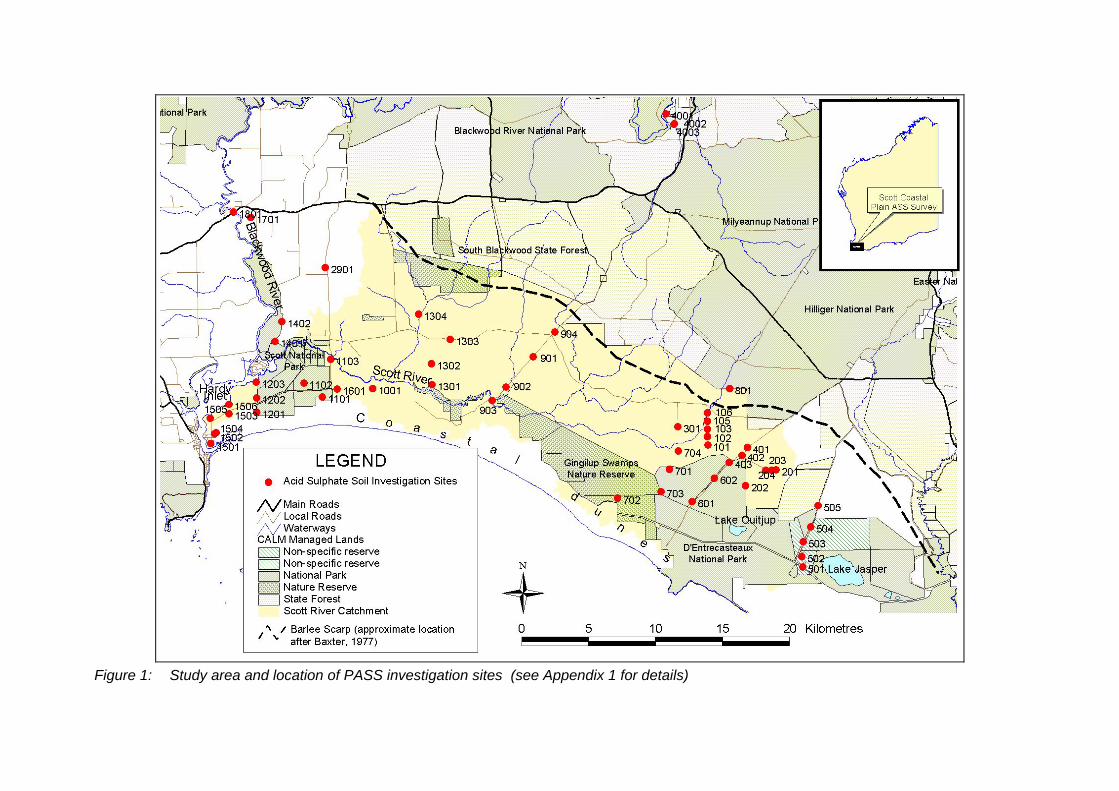
Figure 1: Study area and location of PASS investigation sites (see Appendix 1 for details)
Acid sulfate soil survey of the shallow regolith on the Scott Coastal Plain Hydrogeological record series, Report no. HG24
Department of Water 7
2 Investigation and mapping methods On-ground investigations of acid sulfate soils (ASS) involved strategic coring to identify broad relationships between shallow lithology, the occurrence of ASS horizons and geomorphology. This approach follows the standard soil-mapping techniques as detailed in Gunn et al. (1988). Information from the on-ground work was used to describe the general characteristics of ASS (PASS and AASS) on the Scott Coastal Plain, including the hydrogeological context of the materials. This formed the basis for evaluating risks associated with lowering shallow groundwaters in the shallow regolith. The mapping process is outlined below.
2.1 Preparation of the base map
Analysis of existing spatial information and development of regional conceptual models of PASS occurrence
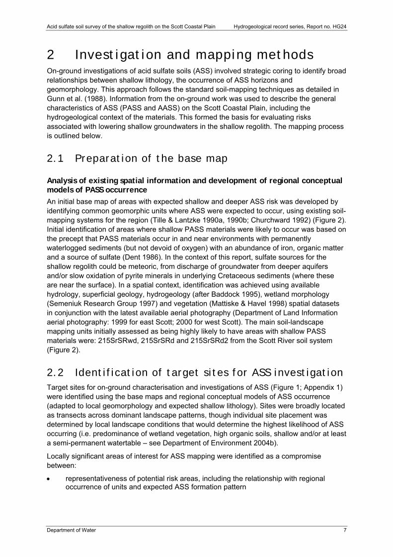
An initial base map of areas with expected shallow and deeper ASS risk was developed by identifying common geomorphic units where ASS were expected to occur, using existing soil-mapping systems for the region (Tille & Lantzke 1990a, 1990b; Churchward 1992) (Figure 2). Initial identification of areas where shallow PASS materials were likely to occur was based on the precept that PASS materials occur in and near environments with permanently waterlogged sediments (but not devoid of oxygen) with an abundance of iron, organic matter and a source of sulfate (Dent 1986). In the context of this report, sulfate sources for the shallow regolith could be meteoric, from discharge of groundwater from deeper aquifers and/or slow oxidation of pyrite minerals in underlying Cretaceous sediments (where these are near the surface). In a spatial context, identification was achieved using available hydrology, superficial geology, hydrogeology (after Baddock 1995), wetland morphology (Semeniuk Research Group 1997) and vegetation (Mattiske & Havel 1998) spatial datasets in conjunction with the latest available aerial photography (Department of Land Information aerial photography: 1999 for east Scott; 2000 for west Scott). The main soil-landscape mapping units initially assessed as being highly likely to have areas with shallow PASS materials were: 215SrSRwd, 215SrSRd and 215SrSRd2 from the Scott River soil system (Figure 2).
2.2 Identification of target sites for ASS investigation Target sites for on-ground characterisation and investigations of ASS (Figure 1; Appendix 1) were identified using the base maps and regional conceptual models of ASS occurrence (adapted to local geomorphology and expected shallow lithology). Sites were broadly located as transects across dominant landscape patterns, though individual site placement was determined by local landscape conditions that would determine the highest likelihood of ASS occurring (i.e. predominance of wetland vegetation, high organic soils, shallow and/or at least a semi-permanent watertable – see Department of Environment 2004b).
Locally significant areas of interest for ASS mapping were identified as a compromise between:
representativeness of potential risk areas, including the relationship with regional occurrence of units and expected ASS formation pattern

Hydrogeological record series, Report no. HG24 Acid sulfate soil survey of the shallow regolith on the Scott Coastal Plain
8 Department of Water
legal and safety access constraints, including minimising the number of cadastral units accessed (for a transect) and landholders engaged for site access to facilitate speed of on-ground investigations; and avoidance of underground power, gas or telephone services (and overhead powerlines)
physical access for coring, such as access tracks with minimal vegetation, trafficable paths and limits of vehicle access
the potential for additional sites to complement target sites to provide a full representative cross-section of geomorphic units.
Problems in meeting safety and physical access criteria meant it was not possible to conduct in-depth shallow regolith investigations in all desired areas (given the time available). In such situations, observations of surface features were used to evaluate ASS risk, combined with occasional inspection of shallow soil profiles using a hand auger.
Additional sites were often selected based on the results on initial coring, usually where further information was needed to confirm the presence or absence of ASS in particular regolith occurrences, to clarify relationships with geomorphic features or verify ASS distribution within a map unit.
Figure 2: Soil-landscape mapping units and dominant landforms for the Scott River soil system (after Tille & Lantzke 1990a,b; Churchward
1992) on which PASS material investigations were focused and regional soil systems in adjoining landscapes
Hydrogeological record series, Report no. HG24 Acid sulfate soil survey of the shallow regolith on the Scott Coastal Plain
10 Department of Water
2.3 Site characterisation, lithological description and ASS sampling
Investigations involved initial descriptions of site characteristics (dominant vegetation, landform) followed by descriptions and field testing of soil cores with selected sampling and laboratory analysis of regolith horizons/layers. Investigations were carried out using the standard ASS investigation methods described in Appendix 2. These involved description of lithology, textures, colours (including mottling), concretions, consistency, organic materials and depth of standing watertable, where encountered.
The shallow regolith was typically cored to 6 m using the DEC’s GeoprobeTM soil-coring system where discrete, sequential 38 mm diameter x 1 m length cores were collected within Teflon liners. Geoprobe core-catchers were used within the core barrels for recovery of unconsolidated materials. Where significant layers of impenetrable iron-cemented sand (commonly referred to as ‘coffee rock’) occurred, increased depth of coring was achieved by blind-bit augering (150 mm diameter) through the layers, followed by probe coring below this. Where site access for the drill rig was limited, the regolith was cored using a 100 mm diameter stainless steel hand auger to 1–2.5 m, depending on the nature of the profile.
Field testing for ASS was carried out at 0.25 m depth intervals and samples were collected at 0.5 m depth intervals for future analysis (Appendix 2). The collected samples were sealed in air-tight zip-lock bags, with as much air as possible excluded, and immediately frozen in field refrigerators before transport to a storage freezer at the DEC facilities in Welshpool.
2.4 Sample handling and analysis Selected samples were submitted to commercial laboratories for preparation and/or further analysis for ASS characteristics on the basis of interpretation of field descriptions and field ASS testing. Samples were prepared for analysis by drying at 80°C for a minimum of 48 hours, sieving to <2 mm (with removal of visible shell materials) and grinding (as per QASSIT method 22b; Ahern et al. 2004). The DEC retained subsamples of all prepared samples in air-tight vials flushed with nitrogen gas. The decision to carry out laboratory analysis of samples was primarily guided by the need to verify field test results (both positive and negative indications of ASS) and provide representative information on the chemical characteristics of ASS materials.
Laboratory analysis of prepared samples involved determining actual acidity. This involved a combined measurement of pH (pHKCl determined in 1M KCl extracts) and existing acidity (total titratable acidity or TTA; QASSIT methods 23A and 23F; Ahern et al. 2004). Using this approach, existing acidity includes exchangeable acidity, acidity associated with organic matter and soluble acidity (Ahern et al. 2004) not accounted for by pH measurement alone (which only determines H+ acidity).
Stored acidity in unoxidised sulfides was estimated by chromium-reducible sulfur analysis (QASSIT method 22B; Ahern et al. 2004). PASS materials in this survey identified by chromium-reducible sulfur analyses were unlikely to include assay of many monosulfidic materials because sample handling and preparation processes were likely to have resulted in the oxidation of these before testing.
Samples with initial laboratory pH less than 4.5 were analysed to determine acid-soluble sulfate fractions (QASSIT methods 23C and 20B; Ahern et al. 2004), providing an indicator of
Acid sulfate soil survey of the shallow regolith on the Scott Coastal Plain Hydrogeological record series, Report no. HG24
Department of Water 11
iron and/or aluminium-hydroxy sulfate minerals (stores of insoluble acidity) formed under acidic conditions and therefore evidence of formation of actual ASS materials. Analysis of acid-soluble sulfate fractions was also undertaken on samples where there were strong indications of actual ASS materials in field pH (pH <4) and profile indicators, since pHKCl determined after sample preparation occasionally resulted in pH values that were more than two units greater than field pH values.
Samples with initial pH exceeding 6.5 were analysed to determine acid-neutralising capacity (QASSIT method 19A1; Ahern et al. 2004). This measurement indicates the alkalinity stores in carbonate, organic matter, clay minerals and reactive surfaces in soils that might offset acid generation by oxidation of PASS materials (Ahern et al. 2004).
2.5 Data storage, quality assurance and quality control
All site and regolith descriptions, as well as field testing and laboratory analysis results are stored in the Water Information Database – a corporate relational database designed to manage data from environmental sampling programs. Development and implementation of a data management strategy at the start of the state-wide ASS risk-mapping project ensured the data collected and stored for the project was high quality. This strategy involved data and sample tracking using chain of custody and field observation forms, and cataloguing of sites and samples using unique reference numbers. Validation and verification processes involving cross-checking against regolith descriptions and related data was also used during capture and entry of data to achieve high data-quality standards.
Details of quality assurance and control standards applied in the field are outlined in Appendix 2.
2.6 Analysis of field and laboratory data to develop ASS risk map
Data from field surveying, regolith coring and subsequent laboratory tests were analysed to determine characteristics of PASS materials within soil-landscape map units, as well as evaluate consistency of PASS materials within the units and the transition of horizons with PASS materials across sequences of landscape units (when possible).
This process initially involved evaluating PASS characteristics for the shallow regolith at each investigation site and classifying the profile according to ASS disturbance risk. Field ASS test results and laboratory analyses for each profile were evaluated in conjunction with lithological information (texture, colour, mottling, watertable depth) to arrive at an overall characterisation of PASS presence or absence within individual shallow regolith profiles. This involved assessing whether field tests indicated the presence of PASS materials (Department of Environment 2004b), evaluating the reliability of the field test results within a profile by comparison with laboratory analysis results for selected depths, and determining the extent to which the PASS assessment could be applied to lithology information. Chromium-reducible sulfur analysis results (where available) exceeding 0.03 per cent sulfide-S were considered to pose an environmental hazard.
Horizons with oxidised ASS materials were identified using a combination of field and laboratory information. Horizons with significant existing acidity (>3.5 kg H2SO4/tonne) and/or other corroborating evidence of sulfide oxidation (e.g. distinctive mottling pattern, colour,

Hydrogeological record series, Report no. HG24 Acid sulfate soil survey of the shallow regolith on the Scott Coastal Plain
12 Department of Water
proximity to other PASS materials in profile, field ASS test results) were considered to contain oxidised ASS materials. In combination with jarosite mottling, this evidence is generally regarded as diagnostic of a disturbed ASS (Dent 1986; Fanning et al. 1993; Ahern et al. 2004). We have taken a conservative approach by constraining our description to the materials present in the profile, rather than describing the materials as disturbed ASS.
Classification of ASS disturbance risk was applied using the approach outlined in Appendix 3. This involves evaluating whether shallow ASS are likely to be disturbed by normal land-use development activities, including activities that may alter watertable regimes. Shallow ASS materials are those materials within 3 m of the ground surface that have the capacity to influence the near-surface environment and economic resources.
The association between shallow regolith, PASS materials (for transects of sites) and existing soil-landscape mapping units (Tille & Lantzke 1990a, 1990b; Churchward 1992) was evaluated to determine the extent to which the units could be used to map shallow PASS materials. The assessment was also undertaken giving consideration to existing geology, wetland morphology (Semeniuk Research Group 1997) and vegetation mapping (Mattiske & Havel 1998).
Acid sulfate soil survey of the shallow regolith on the Scott Coastal Plain Hydrogeological record series, Report no. HG24
Department of Water 13
3 Results
3.1 Characteristics of acid sulfate soil materials on the Scott Coastal Plain
Much of the shallow regolith in the central coastal plain and southern margins was characterised by deep sands with grey surface horizons, overlying brown and iron-cemented organic rich sands with occasional clayey sand horizons (Appendix 4). Many of the investigation sites with such regolith materials contained PASS materials throughout all horizons below the watertable (at the time of coring); often in dark grey sands, ferruginous/brown sands or iron-cemented layers. However, PASS materials were not confined to such horizons and could occur in white or light grey sands. In many cases it appeared the sulfide content (indicating stored acidity) was generally the same in different horizons within profiles (Appendix 4), though there were instances where sulfide content was concentrated within iron-cemented layers.
Few profiles with PASS materials contained significant peaty materials other than fine humic materials interspersed with sands or within iron-cemented horizons (Appendix 4). Clayey sand horizons occasionally occurred as shallow layers within regolith profiles generally associated with wetland depressions in the upper eastern section of the plain (e.g. sites 102, 103, 601 and 701). Iron-cemented layers frequently occurred in many profiles with PASS materials in the central coastal plain as recurrent 0.25–0.5 m lenses in brown or weakly cemented sands. Toward the Barlee Scarp (southern margin of the Blackwood Plateau) the lenses became more significant (>1 m layers) and the degree of cementation increased (evidenced by limited coring penetration compared with the central plain, where penetration was frequently possible). The degree of cementation did not reflect the amount of acid storage (though it was difficult to obtain core samples of the well-cemented sands for analysis). The cemented layers in profiles in the central plain were not indurated to the extent of constraining groundwater movement, since many were friable and contained fine pores.
Toward the western section of the coastal plain and along the Barlee Scarp, the shallow regolith profiles generally contained clayey sand and sandy clay horizons frequently interlayered or overlain by brown or ferruginous sands. PASS materials in these profiles occurred in brown, ferruginous, organic rich or iron-cemented organic sands as well as white and red-yellow mottled sandy clay and clayey sand horizons. Limited investigation of the shallow regolith north of Fouracres Road (801) and near the Blackwood confluence (1401, 1402 and 1701) indicated that PASS materials could occur within mottled clays and grey clay horizons in these areas. However, the intense iron mottling of all horizons with PASS materials in these profiles suggest that slow oxidation is an inherent characteristic of the profiles and is not a recent event.
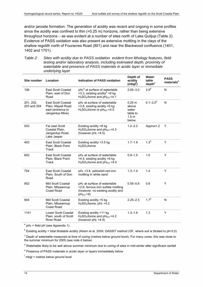
Acidity due to PASS oxidation was evident at over 20 per cent of investigation sites, resulting in the generation of acidity frequently either at or above the watertable (at the time of coring). This acidity had not resulted in the formation of horizons with classical actual ASS, such as jarosite and easily identifiable iron segregations (Dent 1986; Fanning et al. 1993). Instead, many horizons were identified as being actual ASS on the basis of a range of chemical properties (Table 2), which in general were field pH (pHF) <4 and/or laboratory pH (pHKCl) <4.5 with existing acidity and occasionally iron mottling. Absence of iron mottling may have been due to the dominant dark reddish brown to dark grey and black colours of the regolith materials masking identification of mottling characteristics indicative of actual ASS materials
Hydrogeological record series, Report no. HG24 Acid sulfate soil survey of the shallow regolith on the Scott Coastal Plain
14 Department of Water
and/or jarosite formation. The generation of acidity was recent and ongoing in some profiles since the acidity was confined to thin (<0.25 m) horizons, rather than being extensive throughout horizons – as was evident at a number of sites north of Lake Quitjup (Table 2). Evidence of PASS oxidation was also present as extensive mottling in the clays of the shallow regolith north of Fouracres Road (801) and near the Blackwood confluence (1401, 1402 and 1701).
Table 2: Sites with acidity due to PASS oxidation evident from lithology features, field testing and/or laboratory analysis, including estimated depth, proximity of watertable and presence of PASS materials in acidic layer or immediate underlying layer
Site number Location Indication of PASS oxidation Depth of acidity (mbglf)
Water table depthc
PASS materialse
106 East Scott Coastal Plain, east of Don Road
pHFa at surface of watertable
<3.3, existing acidityb >6 kg H2SO4/tonne and pHKCl <4.1
2.65–3.0 2.9d N
201, 202, 203 and 204
East Scott Coastal Plain, Mayall Road east (entrance to Jangardup Mine)
pHF at surface of watertable <3.8, existing acidity >6 kg H2SO4/tonne or pHKCl <4.5
0.25 m above water table to 1.5 m below.
0.1–2.0d N
503 Far east Scott Coastal Plain, Jangardup Road, Lake Jasper
Existing acidity >8 kg H2SO4/tonne and pHKCl <4.3 (however pHF >4.5)
1.2–2.2 Approx1.2 Y
403 East Scott Coastal Plain, Black Point Track
Existing acidity >3.5 kg H2SO4/tonne
1.7–1.9 1.3d Y
602 East Scott Coastal Plain, Black Point Track
pHF at surface of watertable <4.4, existing acidity >6 kg H2SO4/tonne and pHKCl <4.5
0.9–1.5 1.0 Y
704 East Scott Coastal Plain, South of Don Road
pHF <3.8, yellowish-red iron mottling in white sand
1.3–1.4 1.4 Y
902 Mid Scott Coastal Plain, Milyeannup Coast Road
pHF at surface of watertable <2.6, ferrous iron sulfate mottling (however, no existing acidity and pHKCl >9)
0.55–0.8 0.8 Y
904 Mid Scott Coastal Plain, Milyeannup Coast Road
Existing acidity >5 kg H2SO4/tonne, pHF <4.2
2.25–2.5 1.7d N
1101 Lower Scott Coastal Plain, south of Scott River Road
Existing acidity >11 kg H2SO4/tonne and pHKCl <4.2 (however pHF >4.9)
1.3–1.6 1.3 Y
a pHF = field pH (see Appendix 1). b Existing acidity = total titratable acidity (Ahern et al. 2004; QASSIT method 23F, where soil is titrated to pH 6.5) c Depth of watertable measured at time of coring (metres below ground level). For many cores, this was close to the summer minimum for 2005 (see note d below) d Watertable likely to be well above summer minimum due to coring of sites in mid-winter after significant rainfall e Presence of PASS materials in acidic layer or layers immediately below f mbgl = metres below ground level
Acid sulfate soil survey of the shallow regolith on the Scott Coastal Plain Hydrogeological record series, Report no. HG24
Department of Water 15
3.2 Landscape patterns and mapping ASS hazard areas ASS hazard areas were mapped (Figure 3) using existing map units identified in soil-landscape mapping of the Scott Coastal Plain (Tille & Lantzke 1990a; Churchward 1992). There was insufficient density of investigation sites and no additional spatial data – other than that derived from aerial photo interpretation (soil and wetland geomorphology) – to enable delineation of mapping units that might provide more distinction of different forms of ASS hazard in the shallow regolith. Coring intensity was well below the recommended intensity to support production of reliable 1:100 000 mapping (Gunn et al. 1998) and we suggest stakeholders bear this in mind when using the ASS hazard map arising from this investigation.
PASS materials appear to be extensively associated with low-lying seasonal wetlands and damplands as well as underlying minor dunes within the coastal plain. These areas corresponded with much of the Scott River plain soil system (Tille & Lantzke 1990a) and major drainage and swampy tracts mapped by Churchward (1992). Shallow ASS materials occurred in many shallow regolith profiles investigated in this land system (Figure 3). On the western Scott Coastal Plain, regolith with shallow PASS materials were associated with seasonal wetlands and damplands on the margins of the Blackwood floodplain as well as those flats up to 10 m AHD (map unit codes SrSRd, SrSRwd and SrSRd2, Tille & Lantzke 1990a; Table 3). Gently sloping, poorly drained areas to the north-east of the Scott/Blackwood confluence, generally underlaid by highly cemented sands (laterite), also contained evidence of shallow PASS materials (map unit codes SrSRdi and SrSRdwi, Tille & Lantzke 1990a; Table 3). Difficulty in coring the highly cemented sand layers in these areas prevented assessment of whether the layers contained PASS materials, although the extent of cementation may prevent any oxidation or release of this acidity. Although it is not certain if PASS materials occur extensively throughout the SrSRdi and SrSRwi map units, the PASS hazard is highly likely to occur along drainage lines and more low-lying areas.
Shallow PASS materials are not generally expected to occur in the coastal dunes bordering the southern part of the plain. This is due to the watertable levels being below those at which PASS materials generally occur. However, it is likely that thin (<1 m) PASS layers are associated with the upper surface of the watertable beneath the dunes, particularly down-gradient of seasonal damplands within the dunes. PASS can occur in damplands within the coastal dunes, as identified by on-site inspection and field testing on Black Point Track (E: 367 311, N: 6 196 147). These units corresponded with the D’Entrecasteaux low-lying sandy flats and stony sandy flats (map unit codes DxDNd and DxDNrd; Table 3) within the D’Entrecasteaux dunes soil system (Tille & Lantzke 1990a; Churchward 1992).
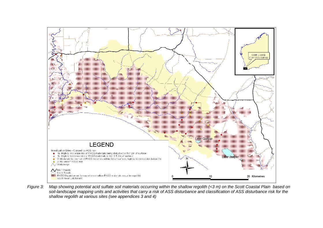
Figure 3: Map showing potential acid sulfate soil materials occurring within the shallow regolith (<3 m) on the Scott Coastal Plain based on
soil-landscape mapping units and activities that carry a risk of ASS disturbance and classification of ASS disturbance risk for the shallow regolith at various sites (see appendices 3 and 4)
Acid sulfate soil survey of the shallow regolith on the Scott Coastal Plain Hydrogeological record series, Report no. HG24
Department of Water 17
On the northern margin of the Scott Coastal Plain and along the Barlee Scarp, spatial occurrence of PASS hazard in the shallow regolith is increasingly patchy with transition to the Blackwood Plateau, where PASS hazard is generally expected to be confined to seasonal wetlands and drainage lines. Deeper mottled clays in the regolith along the scarp, which are most likely the upper weathered layers of the Warnbro Group, appear to contain extensive but low concentrations of PASS materials (e.g. north of Scott National Park – sites 1401, 1402 and 1701 and Jacks Track – site 801). Shallow PASS materials also occurred in some seasonal wetland depressions. These findings indicate that the shallow regolith on the scarp and northern Scott Coastal Plain is likely to contain PASS hazard, though the extremely limited intensity of this investigation (particularly in this area) prevents any systematic identification of areas with PASS hazard.
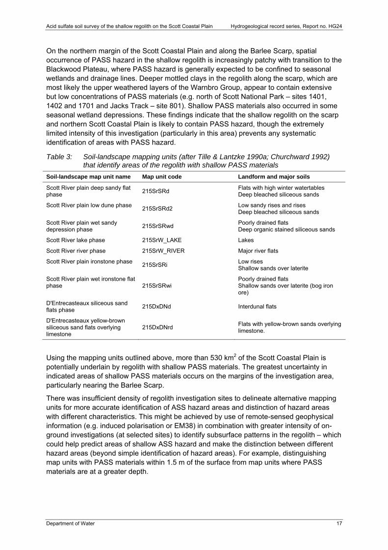
Table 3: Soil-landscape mapping units (after Tille & Lantzke 1990a; Churchward 1992) that identify areas of the regolith with shallow PASS materials
Soil-landscape map unit name Map unit code Landform and major soils
Scott River plain deep sandy flat phase
215SrSRd Flats with high winter watertables Deep bleached siliceous sands
Scott River plain low dune phase 215SrSRd2
Low sandy rises and rises Deep bleached siliceous sands
Scott River plain wet sandy depression phase
215SrSRwd Poorly drained flats Deep organic stained siliceous sands
Scott River lake phase 215SrW_LAKE Lakes
Scott River river phase 215SrW_RIVER Major river flats
Scott River plain ironstone phase 215SrSRi
Low rises Shallow sands over laterite
Scott River plain wet ironstone flat phase 215SrSRwi
Poorly drained flats Shallow sands over laterite (bog iron ore)
D'Entrecasteaux siliceous sand flats phase
215DxDNd Interdunal flats
D'Entrecasteaux yellow-brown siliceous sand flats overlying limestone
215DxDNrd Flats with yellow-brown sands overlying limestone.
Using the mapping units outlined above, more than 530 km2 of the Scott Coastal Plain is potentially underlain by regolith with shallow PASS materials. The greatest uncertainty in indicated areas of shallow PASS materials occurs on the margins of the investigation area, particularly nearing the Barlee Scarp.
There was insufficient density of regolith investigation sites to delineate alternative mapping units for more accurate identification of ASS hazard areas and distinction of hazard areas with different characteristics. This might be achieved by use of remote-sensed geophysical information (e.g. induced polarisation or EM38) in combination with greater intensity of on-ground investigations (at selected sites) to identify subsurface patterns in the regolith – which could help predict areas of shallow ASS hazard and make the distinction between different hazard areas (beyond simple identification of hazard areas). For example, distinguishing map units with PASS materials within 1.5 m of the surface from map units where PASS materials are at a greater depth.
Hydrogeological record series, Report no. HG24 Acid sulfate soil survey of the shallow regolith on the Scott Coastal Plain
18 Department of Water
3.3 Estimated potential acid storage at investigation sites
Acid chemically stored within unreacted sulfides (within PASS layers) was calculated at each site (expressed as tonnes H2SO4 per ha; see Appendix 4) to indicate the nature of the ASS hazard across the catchment. Estimates of stored acidity indicate the worst-case scenario acidity that would be generated should the upper 1 m layers of saturated regolith containing PASS materials be exposed to air by any practice that rapidly lowers the summer watertable or disturbs shallow profiles. However, the estimates represent the acid storage in the area immediately surrounding the core sites and do not represent average acid storage for areas beyond this.
Estimates of acid storage were applied only to the upper 1 m of the regolith judged to contain PASS materials (see Section 2.6) using sulfide analysis results from laboratory tests (estimated by chromium-reducible sulfur). Analysis results were applied across horizon intervals where they were consistent with field testing or lithology. In some instances, information from only a single sample was collected, in which case the result was averaged across the estimation interval (1 m). Bulk densities of regolith materials were assumed to be an average of 1.2 tonnes/m3, since many of the shallow regolith profiles were fine sandy to silty sand materials. However, some underestimation of stored acidity is likely to have occurred for clays and some highly cemented sands, since the bulk density of these was likely to have been greater than 1.2 tonnes/m3.
There was an estimated storage of more than 30 tonnes of H2SO4/ha as sulfides within the surface 1 m of PASS materials at many sites across the Scott Coastal Plain. Acid storage generally varied between less than 9 to more than 60 tonnes H2SO4/ha (Figure 4), with three sites exceeding 150 tonnes H2SO4/ha. Site 701 contained 174 tonnes H2SO4/ha on the eastern margin of Gingilup Swamps, whereas site 1301 near the Scott River and site 1202 south of Scott River Road in the western part of the catchment contained 238 and 164 tonnes H2SO4/ha respectively (Figure 4; Appendix 4). The only distinct regional pattern is that acid storage is greater in the lower parts of the landscape along the Scott River and near the coastal dunes than in the upper areas of the landscape near the Barlee Scarp (Figure 4).
3.4 Existing acidity Concentrations of existing acidity equivalent to more than 3 kg H2SO4/tonne were present within sandy horizons of the shallow regolith at a number of sites, mainly in the eastern part of the catchment (east of Gingilup Swamps). At more than seven sites, this acidity was between 6 and 11 kg H2SO4/tonne (see Table 2), which equates to between 72 and 132 tonnes H2SO4/ha (for a 1 m layer of regolith materials). Assuming the existing acidity had solely originated from the oxidation of PASS materials (assuming no movement of acidity), this would have been equivalent to unoxidised PASS materials of more than 0.2 per cent (w/w) sulfide-S. At many sites there were indications of residual PASS materials present or immediately below in the layers where existing acidity occurred.
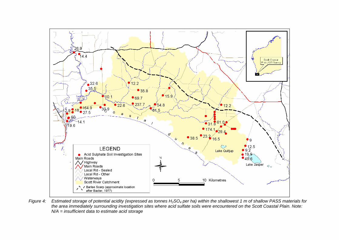
Figure 4: Estimated storage of potential acidity (expressed as tonnes H2SO4 per ha) within the shallowest 1 m of shallow PASS materials for
the area immediately surrounding investigation sites where acid sulfate soils were encountered on the Scott Coastal Plain. Note: N/A = insufficient data to estimate acid storage
Hydrogeological record series, Report no. HG24 Acid sulfate soil survey of the shallow regolith on the Scott Coastal Plain
20 Department of Water
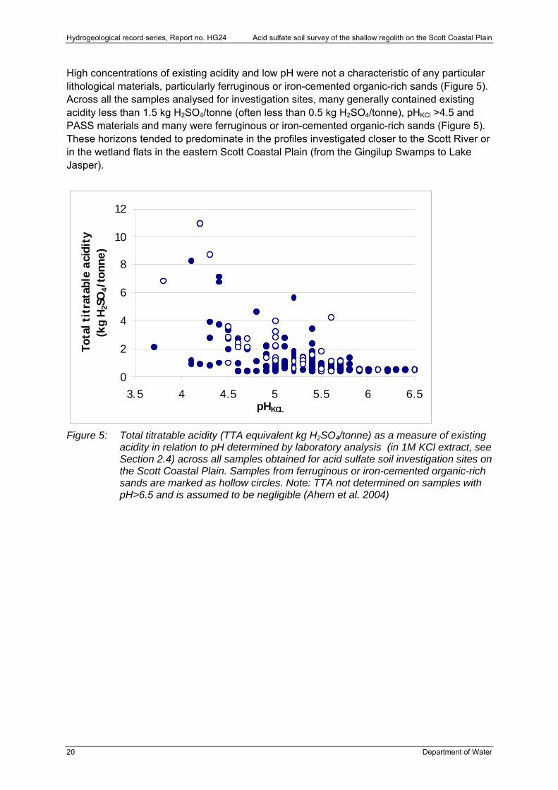
High concentrations of existing acidity and low pH were not a characteristic of any particular lithological materials, particularly ferruginous or iron-cemented organic-rich sands (Figure 5). Across all the samples analysed for investigation sites, many generally contained existing acidity less than 1.5 kg H2SO4/tonne (often less than 0.5 kg H2SO4/tonne), pHKCl >4.5 and PASS materials and many were ferruginous or iron-cemented organic-rich sands (Figure 5). These horizons tended to predominate in the profiles investigated closer to the Scott River or in the wetland flats in the eastern Scott Coastal Plain (from the Gingilup Swamps to Lake Jasper).
0
2
4
6
8
10
12
3.5 4 4.5 5 5.5 6 6.5pHKCL
Tota
l ti
trat
able
aci
dit
y(k
g H
2SO
4/t
onne)
Figure 5: Total titratable acidity (TTA equivalent kg H2SO4/tonne) as a measure of existing
acidity in relation to pH determined by laboratory analysis (in 1M KCl extract, see Section 2.4) across all samples obtained for acid sulfate soil investigation sites on the Scott Coastal Plain. Samples from ferruginous or iron-cemented organic-rich sands are marked as hollow circles. Note: TTA not determined on samples with pH>6.5 and is assumed to be negligible (Ahern et al. 2004)
Acid sulfate soil survey of the shallow regolith on the Scott Coastal Plain Hydrogeological record series, Report no. HG24
Department of Water 21
4 General discussion
4.1 Shallow regolith with potential ASS materials on the Scott Coastal Plain
Much of the shallow regolith in the low-lying land of the Scott River catchment contains PASS materials within deep sandy profiles (varying in iron cementation) with occasional sandy clay and clay horizons at depth. More than 50 sites selected to represent broad transects (in readily accessible areas) were investigated for ASS – with 90 per cent of these being found to contain PASS materials and just under half containing PASS materials within 2 m of the soil surface. PASS materials frequently occurred within 1 m of the watertable, which was most likely near the summer minimum at the time of coring (late autumn to early winter). At a number of sites the PASS materials appeared to be concentrated in several layers, whereas for many sites ASS materials occurred throughout all horizons below the watertable (evident at least to the depth of coring at 6 m below ground level).
The potential acidity estimated to be stored within the shallowest 1 m of horizons with PASS materials ranged from less than 10 to more than 150 tonnes H2SO4/ha. It was likely that acid storage could exceed this in many wetland basins (not investigated in this work), facilitated by the likely greater organic matter content of soils in these environments. Furthermore, PASS materials are likely to be much closer to the ground surface in these environments and therefore immediately prone to declines in minimum watertable levels and oxidation by fires.
There are likely to be areas of ASS hazard not identified, due to the limited time and extent of this survey. PASS materials may occur (not confirmed) in association with buried horizons beneath the northern edges of the coastal dunes that border the southern extent of the catchment. Furthermore, the occurrence of low levels of ASS materials (0.03–0.04 per cent sulfide-S) in clays underlying gently sloping areas on and at the margins of the Blackwood plateau indicate that wetlands in these upland areas may contain concentrations of shallow ASS materials. Limited investigation has identified evidence of shallow ASS materials in the lower floodplain of the Blackwood River (between Alexander Bridge and Nannup) and at Milyeannup Brook (see Appendix 4, sites 2801, 2802, 4001, 4002 and 4003) and highlight that ASS materials may occur in other parts of these environments.
More than 20 per cent of sites investigated had evidence of high concentrations of existing acidity that were most likely due to ASS materials. Residual PASS materials occurred either within or immediately below acidic layers (see Table 2) at most sites, therefore oxidation of these was the most likely source of the existing acidity. The acidified soils occurred across the catchment and did not appear to follow any particular spatial pattern. However, disturbance at a number of sites may be linked with nearby human activities. High levels of existing acidity could not solely be explained as an inherent property of ferruginous or iron-cemented organic-rich sands (commonly called ‘coffee rock’), since there were profiles in which materials occurred that did not contain high existing acidity.
The incidence of acidity in the shallow regolith due to PASS oxidation is likely to be much greater than what has been identified by this survey. This is mainly because investigation sites were not specifically targeted to evaluate areas where acidity generation is occurring due to disturbance of PASS materials and therefore such sites were only found by accident. An investigation program specifically targeting areas where the greatest changes in groundwater levels may have occurred would identify more of the areas missed by the series of broad transects reported on here (see Section 4.6 for recommendations on further work).
Hydrogeological record series, Report no. HG24 Acid sulfate soil survey of the shallow regolith on the Scott Coastal Plain
22 Department of Water
4.2 Shallow regolith with acidity due to PASS oxidation on the Scott Coastal Plain
Much of the existing (or released) acidity at sites considered to have oxidised PASS materials occurred above, at or just below the watertable at the time of coring – strongly indicating that watertable declines were the most likely source of disturbance causing oxidation of PASS materials. Decline in watertable levels may be due to a number of causes including climate change, groundwater abstraction, historical drainage and change in land use to tree crops (where water use exceeds that of the original native vegetation). Declining trends in rainfall patterns across the state’s South West associated with changing climate are likely to reduce surface-water runoff (Berti et al. 2004) and recharge (Department of Environment 2005). This will increase the likelihood of summer watertables falling below current minimum levels: exposing regolith layers containing PASS materials that were previously permanently submerged and resulting in the release of acidity from these layers as oxidation of PASS materials occurs.
There is a subset of sites in the eastern Scott Coastal Plain where evidence of disturbed PASS materials may be immediately linked with localised disturbance of groundwater regimes. A cluster of sites with disturbed ASS materials north-east of Lake Quitjup (201, 202, 203, 204, 403, 602 and 503) correspond with an area of large seasonal amplitude in groundwater levels, compared with groundwater levels to the south-east, south-west and west (see Figure 10 of Rockwater 2004). Greater amplitude of groundwater levels implies that summer minimums were much lower, either presently or in the recent past; hence it was likely that PASS materials were most likely exposed and oxidised. The increased amplitude may be due to significant abstraction of groundwater at a site just north of Mayall Road (see Figure 17, Rockwater 2004) or alteration of watertables during the mining of mineral sands at the Capel Sands Jangardup Mine. Disturbance of PASS materials at other sites may be due to localised drawdown of summer watertables by blue-gum plantations (e.g. sites 106 and 704 near Don Road) or impacts of artificial drainage in the catchment exacerbated by declining rainfall patterns (e.g. site 402, Milyeannup Coast Road).
The rates of acid movement in landscapes with shallow disturbed ASS will be limited by slow lateral subsurface flows, as a result of the low land-surface gradients and therefore low watertable gradients. Acidity occurring within cemented sands may also move more slowly than acidity in the more porous grey and brown sands (frequently overlying or underlying the cemented sands). It is therefore likely that considerable acidity could accumulate within disturbed areas of the shallow regolith well before the full extent of the impacts becomes evident in waterways and wetlands. By this stage, the severity and quantity of acidity stored within the shallow regolith may be to the extent of limiting future management options to contain it within soil profiles: high-energy input, intensive treatment of waterways may be required to minimise impacts of acid discharge to downstream waterways and wetlands.
Declining trends in pH that are emerging in the Scott Coastal Plain’s surface waters may be early warning signs that acid generation is occurring from disturbed ASS materials – to the extent it is starting to impact on surface-water quality. Surface-water quality monitoring over eight years indicates that pH is clearly declining in one waterway (pers. comm. Rob Donohue 2006) in the north-east of the catchment (flowing southwards from the Barlee Scarp across Fouracres Road) and is starting to decline at a second waterway in the north of the catchment (also flowing southwards from the Barlee Scarp near Dennis Road). These areas correspond with where PASS materials are generally closest to the surface of the summer watertable and may be slowly releasing acidity, as has been detected in soil profiles
Acid sulfate soil survey of the shallow regolith on the Scott Coastal Plain Hydrogeological record series, Report no. HG24
Department of Water 23
occurring in similar, adjoining landscapes (e.g. sites 106 and 904). The decline in pH may be due either to widespread but small increases in the acidification of shallow soil profiles or a significant localised release of acid in soil profiles. In either case, the changes in surface-water chemistry deserve immediate attention to determine whether localised or broadscale acid generation from disturbed PASS materials is the main factor behind declining river-water pH.
In conclusion, there is evidence that further declines in minimum shallow watertable levels (by any cause) have the potential to increase the spatial extent of shallow regolith with significant acidity, similar to what has already begun to occur at sites identified by chance in this survey. Further pressures on minimum watertable levels include increased perennial cropping (e.g. tree plantations), increased use of groundwater resources that impact on shallow watertable levels, or any changes in catchment drainage (increasing discharge and therefore altering catchment water-balance). These will need to be considered in addition to the likely impacts of changes in watertables due to climate change.
4.3 Environmental risks posed by ASS on the Scott Coastal Plain
The widespread nature of shallow PASS materials on the Scott Coastal Plain indicates a threat of significant acid being concurrently generated in large areas should widespread declines in minimum watertable levels occur to the extent of exposing (and therefore disturbing) these layers. This scenario could result in widespread environmental and economic impacts emerging across the same area, though the local expression of these may be different depending on local regolith, hydrological and ecological conditions (see Table 4). The worst-case scenario hydrogeochemical processes that might occur in the shallow regolith as a result of widespread acid release from disturbed PASS materials are outlined below. They are linked to larger scale, longer-term processes likely to occur at subcatchment and catchment scales over time (Table 4). In addition, they are based on impacts that have been scientifically validated in landscapes where disturbance of ASS has caused acid release (in Australia and internationally) and are intended to broadly outline the complex range of processes that might be triggered by disturbance of ASS. However, it must be emphasised that considerable uncertainty exists about predicting and therefore managing the outcomes of disturbing PASS materials. It is for this reason alone that the first guiding principle of the national management strategy for ASS has been ‘avoid disturbance’ (National Working Party on Acid Sulfate Soils 2000).
Shallow potential acidity stored in much of the Scott Coastal Plain is likely to be rapidly released as sulfuric acid – should the soil layers with PASS materials be exposed to oxygen by sudden lowering of minimum watertables or by excavation of soil materials. Oxidation of PASS materials would occur when summer watertables fall and expose horizons with PASS materials. Sulfuric acid would accumulate in the zone where PASS materials have been exposed to air (by lower watertables), resulting in the formation of minerals with stored acidity (e.g. jarosite). PASS materials in much of the shallow regolith are likely to oxidise quickly, given that many materials occur in predominantly sandy horizons where air entry under unsaturated (but moist) conditions is likely to be unimpeded. These conditions would provide a soil environment that facilitates speedy progression of sulfide oxidation reactions (Dent 1986).
Because many PASS materials occur within iron-cemented sands in much of the shallow regolith, initial PASS oxidation rates as well as the mobility of released acidity may be slowed
Hydrogeological record series, Report no. HG24 Acid sulfate soil survey of the shallow regolith on the Scott Coastal Plain
24 Department of Water
(due to the likely low porosity – see Section 3.1). However, this will result in a build-up of existing acidity with delayed transport to the environment possibly in pulse events.
Neutralisation of the acidity released by PASS oxidation is likely to be slow or limited. The high organic and iron content of many horizons in which PASS materials occur may buffer acidity initially. However, this could result in increased mobility of iron and organic materials in shallow groundwater layers (Table 4). Furthermore, there were no carbonate materials in many shallow regolith profiles (except towards the western section of the plain, alongside the coastal dunes) and pH values of regolith materials were commonly less than 5, indicating little capacity to neutralise acid released by PASS oxidation (Ahern et al. 2004). Reliable evaluation of whether acid generated by PASS oxidation will be neutralised by in situ neutralising capacity requires the rates of acid generation and likely rates of neutralisation to be determined (Ward et al. 2004a).
The dynamics of acid accumulation within profiles will strongly determine whether factors such as reformation of PASS materials below the watertable (generating alkalinity) will offset acid generation above the watertable. PASS materials can reform in resubmerged soils and generate alkalinity through the process of sulfate reduction (Dent 1986); however, this process may be limited in profiles with significant acidity, limited organic matter or if the organic matter is not readily decomposable (Ward et al. 2004b). On the Scott Coastal Plain, acid generation may only occur during times of low summer groundwater levels (when PASS materials are exposed), with reformation occurring during winter submergence if acidity is minor. There may be sufficient decomposable organic matter within soil profiles to enable some seasonal reformation of PASS materials, but only if rates of acid generation are slow. Since it was possible for significant existing acidity to already occur below the watertable in some profiles on the Scott Coastal Plain (see Section 3.1, Table 2), PASS reformation processes may be limited.
The mobility of acidity generated by disturbance of PASS materials and factors controlling this are not certain. Acidity occurring within cemented sands may be leached more slowly than the more porous grey and brown sands (frequently overlying or underlying the cemented sands). In most cases, however, local hydrology will control the rate of transport of acid from profiles. This may occur slowly through shallow groundwater or rapidly by surface flows where groundwater rises to the surface.
Several factors will strongly influence where the effects of disturbing PASS materials might first be evident on the plain. Shallow PASS materials could occur within the regolith on the southern margin of Blackwood Plateau (along the margins of the Barlee Scarp), which may be more sensitive to changes in local water-balance (e.g. sites 106 near Don Road and 801 on Jacks Track). Although PASS materials in the regolith in these areas are not extensive and are likely to be generally confined to wetlands, damplands and seasonal waterways (see Section 3.2), preservation of undisturbed PASS materials strongly depends on maintenance of localised (often perched) groundwater systems. Changes in localised water-balance due to activities such as tree cropping (resulting in increased evapotranspiration), drainage (increasing rate of discharge from catchments, reducing infiltration) and the use of groundwater that lowers surface-water tables carry the risk of exposing and disturbing ASS layers.
Disturbed PASS materials can result in contamination of shallow groundwater with high concentrations of dissolved iron, aluminium and possibly other trace metals. The intense acidity generated by oxidation of PASS materials can chemically dissolve clays (that can contain aluminosilicate minerals) and result in high concentrations of soluble aluminium.
Acid sulfate soil survey of the shallow regolith on the Scott Coastal Plain Hydrogeological record series, Report no. HG24
Department of Water 25
Soluble aluminium can be highly toxic to aquatic life (Nordstrom & Ball 1986), particularly during the process of neutralisation (e.g. when acid surface waters or groundwaters mix with alkaline waters). In the context of the Scott Coastal Plain, this is most likely when alkaline groundwaters (and surface waters) from the coastal dunes mix with stream waters from the central and northern parts of the plain. Soluble aluminium in shallow groundwaters can also reach concentrations that are toxic to plants accessing this water (Rorison 1972; Slattery et al. 1999). Some plants may tolerate high levels of soil aluminium, yet recruitment and establishment of new plants may be limited (Slattery et al. 1999).
Acid generated by disturbance of PASS materials can trigger mobilisation of stored metals in the shallow regolith, particularly during the time when intense acidity occurs. Trace metals may be mobilised from minerals in the regolith profiles and from within the PASS materials. Analyses of total metal content (by HNO3/HCl acid digestion) for selected horizons with PASS materials on the Scott Coastal Plain indicated that arsenic could occur at up to 30 mg/kg – 1.5 times greater than regulatory safe levels of 20 mg/kg (Department of Environment 2003) – with levels 5–7 mg/kg at five sites. These metals may occur naturally in the regolith, most likely associated with iron oxides (Hamon et al. 2004), but can also be magnified in some areas and sediments by application of fertilisers (e.g. trace cadmium in historical superphosphate). Generation of intense acidity and/or changes in redox can alter the stability of iron oxides in regolith profiles and increase the mobilisation of trace metals adsorbed to these oxides (Smith et al. 2003; Kjoller et al. 2004). Some PASS materials, particularly those occurring in peat and organic-rich layers, can include minerals such as arsenopyrites, which are largely chemically similar to iron sulfides (common in many PASS materials) except that oxidation produces arsenic in large concentrations (Appleyard et al. 2005).
Long-term impacts of acid release from PASS materials across a large area, followed by likely seasonal transport of this to surface waterways, risks extensive secondary ASS impacts on the Scott Coastal Plain environment. These impacts are broadly outlined in Table 4 and are likely to occur initially in lakes, creeks, wetlands and eventually the Hardy Inlet into which the Scott River flows.

Hydrogeological record series, Report no. HG24 Acid sulfate soil survey of the shallow regolith on the Scott Coastal Plain
26 Department of Water
Table 4: Potential consequences of acid sulfate soil disturbance and the subsequent generation of acidic water
Scale Manifestation of disturbed ASS
Main risk pathway and receptor
Key receptors (environmental and anthropogenic)
Potential consequence
Onsite/ local Issues
Localised surface soil acidity
Acidic groundwaters rising to surface soil layers during winter
Surface vegetation (natural, agricultural, silvicultural)
Surface soils
Localised soil scalding (Rosicky et al. 2004).
Plant death or poor plant growth and recruitment (Rorisan 1972).
Nutrient and toxic ion stressed plants including periodically increased salinity (Slattery et al. 1999; Rosicky et al. 2006).
Increased susceptibility to disease.
Concentration of toxic ions and iron sulfate salts near surface.
Soil may cause lesions to animals occupying areas during winter.
Extensive acidity in the shallow regolith
Acid accumulation above and at surface of watertable beneath natural ecosystems and land used for agriculture, horticulture and silviculture
Deep rooted perennial vegetation (natural, silvicultural)
Adjoining local waterways and wetlands
Agricultural/horticultural/silvicultural land
Reduced plant growth and recruitment, nutrient and toxic ion stressed plants, increased susceptibility to disease and water stress.
Reduced seedling establishment, nutrient and toxic ion stressed plants, increased susceptibility to disease and water stress.
Natural ecosystems
Poor subsoil root growth due to acidic (Al toxic) subsoils (Adarns & Moore 1983) reduced root access of shallow groundwater water stress and reduced nutrient uptake
Altered nutrient cycling over the long term (Rorison 1972).
Increased susceptibility to disease (poor plant nutrition and increased susceptibility to drought).
Poor recruitment (e.g. after fire and with plant community ageing) due to seedlings not able to access shallow watertable.
Changed flora and faunal community structures. Localised
shallow acidic groundwater
Localised use of shallow groundwater (irrigation, farm water supplies)
Irrigated crops/pastures
Agricultural livestock
Human health (if shallow water consumed)
Death of irrigated plants, acidity burns and acute aluminium toxicity (Appleyard et al. 2004).
Accelerated corrosion by acidity and iron clogging of pumping infrastructure.
Poor stock drinking water quality (potential animal health impacts, and metal bioaccumulation risk – see section in this Table on regional groundwater risk)

Acid sulfate soil survey of the shallow regolith on the Scott Coastal Plain Hydrogeological record series, Report no. HG24
Department of Water 27
Scale Manifestation of disturbed ASS
Main risk pathway and receptor
Key receptors (environmental and anthropogenic)
Potential consequence
Offsite/ regional issues
Regionally acidic shallow groundwaters
Localised discharge of groundwater to third-order streams (mixing with waters pH>6)
Aquatic flora and fauna and riparian ecosystems of third-order and second-order streams
Localised accumulation of large volumes of iron precipitates with episodic flushing downstream (Ferguson & Eyre 1996) death of macroinvertebrates, crustacea (marron etc.) and macrophytes due to iron smothering of downstream systems.
Localised but highly spatially variable toxic zones of aluminium precipitates as Al rich groundwaters are neutralised (Nordstrom & Ball 1986) death of macroinvertebrates, crustacea (marron etc.) and macrophytes due to variably toxic aluminium levels in downstream systems.
Localised formation of monosulfides in streams as unstable, organic-rich sediments with episodic flushing degrading downstream ecosystems during high flows (iron smothering can occur) (e.g. Bush et al. 2004).
Zones of heavy metal concentration in unstable monosulfides (e.g. Smith & Melville 2004), with rapid release to downstream environments during high flows (Bush et al. 2004).
Increased colouration and eutrophication of streams due to increased leaching of organic matter (increasing dissolved organic carbon in waters) and nutrients from organic-rich subsoils and riparian zones by acidic waters.
Metal bioaccumulation risk to wildlife and agricultural livestock – heavy metals (e.g. arsenic and cadmium) in iron-rich subsoils may be mobilised by acidity and changes in redox of groundwaters and become biomagnified in algae (e.g. Gosavi et al. 2004) and possibly the food chain (e.g. Wang 1987). Greatest risk is for animals with ranges confined to wetlands and/or that consume surface waters during summer.
Offsite/ regional issues
Regionally acidic shallow groundwaters
Localised discharge of groundwater to wetlands (water bodies with little inflow)
Wetland aquatic flora and fauna
Wetland-fringe ecosystems
Accumulation of acidic, aluminium and iron-rich waters in wetlands death of macroinvertebrates, crustacea (marron etc.) and macrophytes due to iron smothering, toxicity of Al and changes in water column clarity (Horwitz & Rogan 2003; Sommer & Horwitz 2001).
Increased seasonal variations in water chemistry due to seasonal formation and oxidation of shallow monosulfidic sediments (Hicks et al. 1999; Bush et al. 2004).
Increased accumulation of heavy metals (e.g. arsenic) within wetland sediments and concomitant increased likelihood of bioaccumulation through the aquatic food chain to impact on bird life (caused by acidic and sometimes anoxic groundwater increasing metal leaching from soils, followed by biogeochemical concentration within monosulfides forming in sediments (see Smith & Melville 2004).
Increased colouration and eutrophication of wetlands due to increased leaching of organic matter (increasing dissolved organic carbon in waters) and nutrients from organic-rich subsoils and riparian zones by acidic waters. In contrast, if excess aluminium leaching dominates, wetland water clarity may increase (e.g. Hicks et al. 1999)

Hydrogeological record series, Report no. HG24 Acid sulfate soil survey of the shallow regolith on the Scott Coastal Plain
28 Department of Water
Scale Manifestation of disturbed ASS
Main risk pathway and receptor
Key receptors (environmental and anthropogenic)
Potential consequence
Regional recharge of deeper aquifers
Water quality of deeper aquifers
Increased recharge of semi-confined aquifers from superficial arising from long-term pumping could also result in changed geochemical conditions (e.g. Smith et al. 2003; Kjoller et al. 2004) due to recharge with waters with increased dissolved organic carbon, nitrate, acidity and trace metals – resulting in increased mobilisation of heavy metals within deeper aquifers and altered water quality of deeper aquifers.
Groundwater abstraction from superficial aquifer
Irrigated crops/pastures
Agricultural livestock
Human health (if shallow water consumed)
Death of irrigated plants, burning by acidity and aluminium (Appleyard et al. 2004).
Accelerated corrosion by acidity and iron clogging of pumping infrastructure.
Poor stock drinking water quality (potential animal health impacts including indirectly increasing susceptibility to disease).
Metal bioaccumulation risk – heavy metals (e.g. arsenic and cadmium) in iron-rich subsoils may be mobilised by acidity (Sohlenius & Oborn 2004) and changes in redox of groundwaters and become biomagnified in the food chain. Long-term pumping of superficial aquifer could also result in localised mixing of groundwaters, changed geochemical conditions and increased mobilisation of heavy metals from iron oxides in deeper horizons (e.g. Smith et al. 2003; Kjoller et al. 2004).
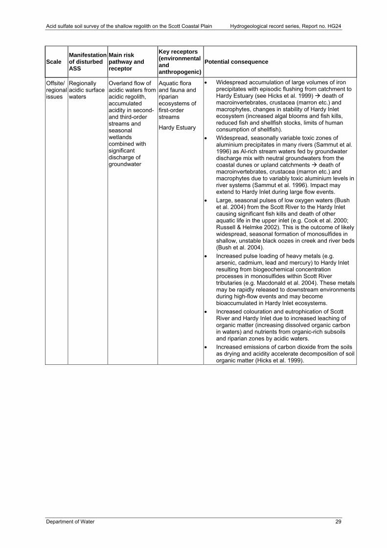
Acid sulfate soil survey of the shallow regolith on the Scott Coastal Plain Hydrogeological record series, Report no. HG24
Department of Water 29
Scale Manifestation of disturbed ASS
Main risk pathway and receptor
Key receptors (environmental and anthropogenic)
Potential consequence
Offsite/ regional issues
Regionally acidic surface waters
Overland flow of acidic waters from acidic regolith, accumulated acidity in second- and third-order streams and seasonal wetlands combined with significant discharge of groundwater
Aquatic flora and fauna and riparian ecosystems of first-order streams
Hardy Estuary
Widespread accumulation of large volumes of iron precipitates with episodic flushing from catchment to Hardy Estuary (see Hicks et al. 1999) death of macroinvertebrates, crustacea (marron etc.) and macrophytes, changes in stability of Hardy Inlet ecosystem (increased algal blooms and fish kills, reduced fish and shellfish stocks, limits of human consumption of shellfish).
Widespread, seasonally variable toxic zones of aluminium precipitates in many rivers (Sammut et al. 1996) as Al-rich stream waters fed by groundwater discharge mix with neutral groundwaters from the coastal dunes or upland catchments death of macroinvertebrates, crustacea (marron etc.) and macrophytes due to variably toxic aluminium levels in river systems (Sammut et al. 1996). Impact may extend to Hardy Inlet during large flow events.
Large, seasonal pulses of low oxygen waters (Bush et al. 2004) from the Scott River to the Hardy Inlet causing significant fish kills and death of other aquatic life in the upper inlet (e.g. Cook et al. 2000; Russell & Helmke 2002). This is the outcome of likely widespread, seasonal formation of monosulfides in shallow, unstable black oozes in creek and river beds (Bush et al. 2004).
Increased pulse loading of heavy metals (e.g. arsenic, cadmium, lead and mercury) to Hardy Inlet resulting from biogeochemical concentration processes in monosulfides within Scott River tributaries (e.g. Macdonald et al. 2004). These metals may be rapidly released to downstream environments during high-flow events and may become bioaccumulated in Hardy Inlet ecosystems.
Increased colouration and eutrophication of Scott River and Hardy Inlet due to increased leaching of organic matter (increasing dissolved organic carbon in waters) and nutrients from organic-rich subsoils and riparian zones by acidic waters.
Increased emissions of carbon dioxide from the soils as drying and acidity accelerate decomposition of soil organic matter (Hicks et al. 1999).
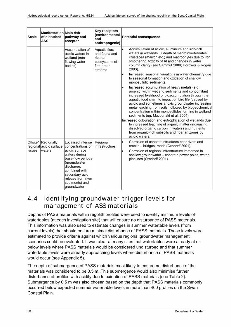
Hydrogeological record series, Report no. HG24 Acid sulfate soil survey of the shallow regolith on the Scott Coastal Plain
30 Department of Water
Scale Manifestation of disturbed ASS
Main risk pathway and receptor
Key receptors (environmental and anthropogenic)
Potential consequence
Accumulation of acidic waters in wetland (non-flowing water bodies)
Aquatic flora and fauna and riparian ecosystems of first-order streams
Accumulation of acidic, aluminium and iron-rich waters in wetlands death of macroinvertebrates, crustacea (marron etc.) and macrophytes due to iron smothering, toxicity of Al and changes in water column clarity (see Sammut 2000; Horowitz & Rogan 2003).
Increased seasonal variations in water chemistry due to seasonal formation and oxidation of shallow monosulfidic sediments.
Increased accumulation of heavy metals (e.g. arsenic) within wetland sediments and concomitant increased likelihood of bioaccumulation through the aquatic food chain to impact on bird life (caused by acidic and sometimes anoxic groundwater increasing metal leaching from soils, followed by biogeochemical concentration within monosulfides forming in wetland sediments (eg. Macdonald et al. 2004).
Increased colouration and eutrophication of wetlands due to increased leaching of organic matter (increasing dissolved organic carbon in waters) and nutrients from organic-rich subsoils and riparian zones by acidic waters.
Offsite/ regional issues
Regionally acidic surface waters
Localised intense concentrations of acidic surface waters during base-flow periods (groundwater discharge, combined with secondary acid release from river sediments) and groundwater
Regional infrastructure
Corrosion of concrete structures near rivers and creeks – bridges, roads (Orndorff 2001).
Corrosion of regional infrastructure immersed in shallow groundwater – concrete power poles, water pipelines (Orndorff 2001).
4.4 Identifying groundwater trigger levels for management of ASS materials
Depths of PASS materials within regolith profiles were used to identify minimum levels of watertables (at each investigation site) that will ensure no disturbance of PASS materials. This information was also used to estimate changes in summer watertable levels (from current levels) that should ensure minimal disturbance of PASS materials. These levels were estimated to provide criteria against which various regional groundwater management scenarios could be evaluated. It was clear at many sites that watertables were already at or below levels where PASS materials would be considered undisturbed and that summer watertable levels were already approaching levels where disturbance of PASS materials would occur (see Appendix 5).
The depth of submergence of PASS materials most likely to ensure no disturbance of the materials was considered to be 0.5 m. This submergence would also minimise further disturbance of profiles with acidity due to oxidation of PASS materials (see Table 2). Submergence by 0.5 m was also chosen based on the depth that PASS materials commonly occurred below expected summer watertable levels in more than 400 profiles on the Swan Coastal Plain.
Acid sulfate soil survey of the shallow regolith on the Scott Coastal Plain Hydrogeological record series, Report no. HG24
Department of Water 31
The risk of the ASS hazard being disturbed by changes in watertables was assessed and not the subsequent risk of significant acid generation from disturbance of PASS materials (see Section 2.6 and Appendix 3). The latter would involve a more detailed environmental risk assessment of disturbance of soils with PASS materials (which is beyond the scope of this work). The assessment would need to consider rates of sulfide oxidation, neutralisation rates, hydrological pathways and receiving environments, which in turn influence generation of acidity, transport off-site and possible environmental impacts.
The relative change in summer watertable levels that are likely to result in minimal disturbance of PASS materials was determined as the difference between the current expected summer watertable and the watertable level below which PASS materials could be disturbed. It was possible to determine expected summer watertable levels at each core site because of the fortuitous coring on the Scott Coastal Plain between April and June (before any winter rainfall in 2005), which was also the time of lowest watertable levels for 2005. This enabled use of the static water level recorded during the investigations as indicators of minimum watertable levels for each site. Where this was not possible, an estimate of expected summer watertable levels was made (using adjoining sites and groundwater information), where possible.
Where the expected summer watertable levels submerged PASS materials by less than 0.5 m, the level of further declines in water tables that would not result in disturbance of PASS materials was considered 0 m. In many situations the trigger level had already been exceeded and no further decline was considered possible without further disturbing PASS materials. For all other sites, where PASS depth or summer watertable levels could be evaluated, safe levels of groundwater change were set as the difference between expected summer watertable levels and 0.5 m above horizons with PASS materials. Where no horizons with PASS materials were evident or shallow cores occurred within the surface 4 m of the watertable, changes in summer watertables that would not disturb PASS materials were deemed to be the limit of the core information or 3 m (whichever was less).
4.5 Implications of ASS occurrence for water quality monitoring
The spatial distribution and characteristics of ASS in the Scott River catchment require a program of shallow groundwater surveillance combined with snapshot and fixed-point surface-water sampling. If designed and implemented correctly, this approach will enable early warning detection of disturbance of ASS and where this is occurring; better predictions of various short-, mid- and long-term environmental, human health and agricultural impacts; and the prioritisation of management strategies to address these impacts. The monitoring approach outlined below focuses on acidity generation due to disturbance of PASS materials.
Shallow groundwater monitoring
Impacts of disturbed ASS will be detectable at the earliest stage as changes in the chemistry of regolith horizons with PASS materials, particularly those within the zone of seasonal groundwater fluctuations. Where watertables decline below the summer minimum levels to expose PASS layers, oxidation of the sulfides will create a layer of acidity that will vary in thickness and intensity throughout the year with winter saturation and summer drying. This has already been evident in the shallow regolith at several sites on the Scott Coastal Plain (see Table 2, Section 3). There is not enough known about the dynamics of the oxidation of
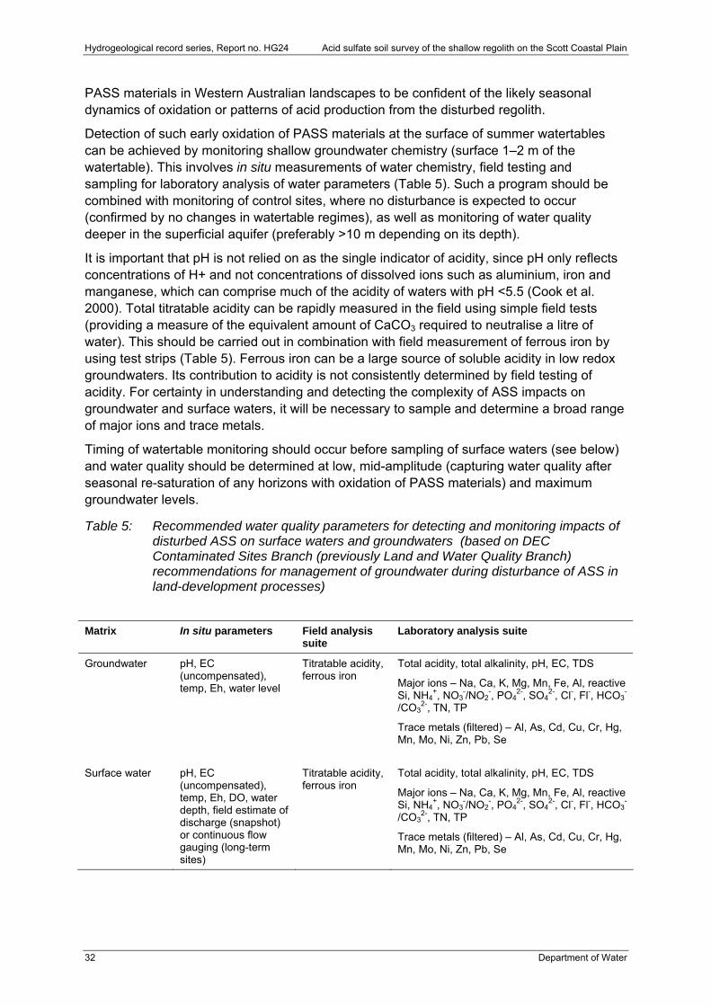
Hydrogeological record series, Report no. HG24 Acid sulfate soil survey of the shallow regolith on the Scott Coastal Plain
32 Department of Water
PASS materials in Western Australian landscapes to be confident of the likely seasonal dynamics of oxidation or patterns of acid production from the disturbed regolith.
Detection of such early oxidation of PASS materials at the surface of summer watertables can be achieved by monitoring shallow groundwater chemistry (surface 1–2 m of the watertable). This involves in situ measurements of water chemistry, field testing and sampling for laboratory analysis of water parameters (Table 5). Such a program should be combined with monitoring of control sites, where no disturbance is expected to occur (confirmed by no changes in watertable regimes), as well as monitoring of water quality deeper in the superficial aquifer (preferably >10 m depending on its depth).
It is important that pH is not relied on as the single indicator of acidity, since pH only reflects concentrations of H+ and not concentrations of dissolved ions such as aluminium, iron and manganese, which can comprise much of the acidity of waters with pH <5.5 (Cook et al. 2000). Total titratable acidity can be rapidly measured in the field using simple field tests (providing a measure of the equivalent amount of CaCO3 required to neutralise a litre of water). This should be carried out in combination with field measurement of ferrous iron by using test strips (Table 5). Ferrous iron can be a large source of soluble acidity in low redox groundwaters. Its contribution to acidity is not consistently determined by field testing of acidity. For certainty in understanding and detecting the complexity of ASS impacts on groundwater and surface waters, it will be necessary to sample and determine a broad range of major ions and trace metals.
Timing of watertable monitoring should occur before sampling of surface waters (see below) and water quality should be determined at low, mid-amplitude (capturing water quality after seasonal re-saturation of any horizons with oxidation of PASS materials) and maximum groundwater levels.
Table 5: Recommended water quality parameters for detecting and monitoring impacts of disturbed ASS on surface waters and groundwaters (based on DEC Contaminated Sites Branch (previously Land and Water Quality Branch) recommendations for management of groundwater during disturbance of ASS in land-development processes)
Matrix In situ parameters Field analysis suite
Laboratory analysis suite
Groundwater pH, EC (uncompensated), temp, Eh, water level
Titratable acidity, ferrous iron
Total acidity, total alkalinity, pH, EC, TDS
Major ions – Na, Ca, K, Mg, Mn, Fe, Al, reactive Si, NH4
+, NO3-/NO2
-, PO42-, SO4
2-, Cl-, Fl-, HCO3-
/CO32-, TN, TP
Trace metals (filtered) – Al, As, Cd, Cu, Cr, Hg, Mn, Mo, Ni, Zn, Pb, Se
Surface water pH, EC
(uncompensated), temp, Eh, DO, water depth, field estimate of discharge (snapshot) or continuous flow gauging (long-term sites)
Titratable acidity, ferrous iron
Total acidity, total alkalinity, pH, EC, TDS
Major ions – Na, Ca, K, Mg, Mn, Fe, Al, reactive Si, NH4
+, NO3-/NO2
-, PO42-, SO4
2-, Cl-, Fl-, HCO3-
/CO32-, TN, TP
Trace metals (filtered) – Al, As, Cd, Cu, Cr, Hg, Mn, Mo, Ni, Zn, Pb, Se

Acid sulfate soil survey of the shallow regolith on the Scott Coastal Plain Hydrogeological record series, Report no. HG24
Department of Water 33
Groundwater monitoring points should be sited to cover a representative range of groundwater regimes in the superficial aquifer – stratified by the ASS characteristics likely to occur in each of these areas. Groundwater regimes that should be covered include those that are undisturbed and slightly perturbed through to those that are likely to have been significantly altered by protracted, localised groundwater abstraction. Groundwater monitoring points also need to cover areas where future changes in groundwater regimes are expected; taking into account points of abstraction that will influence the superficial aquifer, significant localised changes in water-balance due to perennial cropping (e.g. tree plantations) and/or alteration of surface drainage. The latter activities are expected to reduce saturation duration of shallow regolith horizons and increase the extent of summer lowering of watertables. Identification of appropriate monitoring points could be predicted by modelling of shallow groundwater flow paths and rates. This may also be useful to determine whether sites investigated in the current work are suitable as reference sites for long-term monitoring.
Localised placement of monitoring sites should consider variations in ASS characteristics, specifically the depth of sulfide below the watertable, acid storage and characteristics that would determine possible dynamics of ASS oxidation (texture, alkalinity etc.). This information is only broadly available from the current survey work and will need to be determined in more detail when new monitoring sites are installed.
Surface-water monitoring
A spatial snapshot of surface-water chemistry at the start of winter flows is considered necessary to help place groundwater monitoring points in areas where patterns of drainage-water chemistry already indicate disturbed PASS materials (and relatively undisturbed regolith with PASS materials or control sites). Surface-water monitoring will also rapidly identify those areas of the catchment where chemical signatures of ASS oxidation in shallow groundwater are being expressed in surface waterways. There are several water-chemistry parameters including pH, total acidity, iron speciation and the ratio of SO4:Cl (Table 5) that can be evaluated to determine whether shallow groundwater discharging into particular reaches of waterways (between or upstream of sampling points) contains indicators of ASS oxidation. Analysis of trace metals (Table 5) will be essential in evaluating long- and short-term risks to the environment, agricultural activities and human health of acidic discharges to waterways, should these occur. Field estimation of flows for each sampling site will also be necessary to indicate the comparative hydrological contributions of various waterways to overall catchment discharge.
Spatial snapshot monitoring involves targeting a large number of sites on major and minor tributaries, including minor drains and ephemeral waterways across the area of interest within the smallest possible time. Although the approach only provides information for a set of flow conditions, the power of the survey is achieved through the intensity of spatial information and timing of the sampling in relation to flows. Timing of the sampling within the flow year and during particular flow events is critical for using the approach to target water quality signatures that indicate different hydrological flow paths in catchments (Degens & Donohue 2002). For the Scott Coastal Plain, the key time would be to target early season flows as groundwater begins to discharge to creek lines (particularly those in minor waterways) rather than mid- to late-season flows. Flows during these times are likely to be dominated by overland flows or flows from catchment areas with clay soils (mostly during and after rainfall events). Furthermore, the quality of any shallow groundwater component of these flows may have significantly altered from summer and autumn conditions when greatest oxidation of any exposed ASS would be expected to occur.
Hydrogeological record series, Report no. HG24 Acid sulfate soil survey of the shallow regolith on the Scott Coastal Plain
34 Department of Water
The results of snapshot analyses can be used to verify suitable long-term reference monitoring sites where similar sampling will be necessary on a monthly basis, coupled with continuous measurement of flows, to enable efficient and statistically defensible detection of changes in water quality trends. Lack of flow data matching sampling information in many upper catchment sites has been a major limitation to trend analysis using existing surface-water quality information (Jessica Huybregts, pers. comm.).
4.6 Further work . The following further work is suggested:
Site-specific investigations of local scale impacts on shallow ASS materials caused by land-use change (e.g. tree cropping), recent drainage and groundwater abstractions (where watertable levels have changed) should be undertaken. These would provide a baseline for understanding what biogeochemicals occur when lowered summer groundwater levels disturb PASS materials. Such information is needed to predict how acidity will be released and subsequent transformations of this at catchment scales
Investigation of the characteristics, extent, cause and expected changes of localised disturbed ASS north of Lake Quitjup, near Milyeannup Coast Road and south of Don Road. This should be coupled with an investigation into whether impacts are occurring in the adjoining D’Entrecasteaux National Park.
Increased intensity of regolith investigation sites to enable improved resolution of ASS hazard mapping. Current work falls well below the accepted standard to enable production of 1:100 000 scale maps (Gunn et al. 1988) and does not cover areas in the coastal dunes, Barlee Scarp or Blackwood Plateau. Further work should involve exploring whether improved resolution elevation information combined with analysis of LandsatTM, induced polarisation, EM38 or high-resolution spectral imagery identifies spatial patterns that could be useful in improving prediction of the characteristics of shallow ASS hazard (beyond simple identification of hazard areas). For example, distinguishing regolith mapping units with PASS materials within 1.5 m of soil surfaces from regolith mapping units where ASS hazard is deeper may be possible, through greater on-ground investigation linked with mapping approaches that integrate the use of remote-sensed geophysical data.
Identification of areas where declines in shallow groundwater regimes are expected to occur due to predicted decline in rainfall and from land and groundwater use on the Scott Coastal Plain, as well as investigation of the condition of ASS hazards in these areas. This could be achieved by groundwater flow and rate modelling for the superficial aquifer using the Eastern Scott Coastal Plain Local Area Model and the South West Aquifer Modelling System.
Investigations are required to identify whether ASS hazards exist where the watertable is deep in the coastal dunes, particularly where there is a risk that changes in aquifer conditions result in oxidation of PASS materials and altered geochemical conditions.
Further investigation of the extent of existing acidity in shallow horizons combined with further spatial investigations of acidification trends emerging in surface waterways. While it is important to clarify whether surface waterways are starting to acidify and where this is occurring, this is a ‘receiving environment’ monitoring approach. An understanding of where and how much acidity is being generated (and stored) provides characterisation of the ‘source’ and will greatly assist to identify options to manage the issue.
Acid sulfate soil survey of the shallow regolith on the Scott Coastal Plain Hydrogeological record series, Report no. HG24
Department of Water 35
Analysis of all information collected as part of Jangardup Mineral Sands’ mining operations as a basis for identifying ASS impacts and dynamics likely to occur where significant volumes of ASS materials are disturbed.
Investigation of the extent and implications of base-cation leaching due to land-use change (Appleyard pers. comm. 2005). This addresses an over-arching hypothesis that geochemical changes in surface geology formations due to leaching of base-cations will result in widespread reduction in alkalinity within superficial aquifers and increase the risk posed by minor levels of PASS materials (below current action limits for DEC regulation of ASS; Department of Environment 2004b).
4.7 Conclusion More than 50 sites were investigated across the Scott Coastal Plain to broadly define the spatial distribution and characteristics of ASS materials. Of these, 90 per cent contained PASS materials, and in just under half of these, PASS occurred within 2 m of the surface. More than 20 per cent of sites contained evidence of acid release from PASS materials (i.e. actual ASS formation).
PASS materials coincided with soil-landscape units defining low-lying seasonal wetlands and damplands within the Scott Coastal Plain soil system of Tille and Lantzke (1990a) and Churchward (1992). Insufficient density of investigation sites precluded definitive correlation of soil-landscape units to specific PASS risk classes.
A map illustrating the ASS disturbance risk was produced. However, the density of investigation sites is below that which would support production of reliable 1:100 000 scale mapping.
PASS overlain by actual ASS materials at or just below the watertable indicates declines in watertable levels are the likely source of disturbance causing oxidation of PASS at 20 per cent of the investigation sites.
The potential acid storage and groundwater trigger level for management of ASS materials was identified at each investigation site.
Management implications defined by the survey are as follows:
1. The widespread nature of shallow PASS materials indicates there is a threat that significant acid will be concurrently generated across large areas should widespread declines in minimum watertable levels occur.
2. ASS disturbance and the subsequent generation of acidic water, if released, have the potential to cause significant environmental harm at a local and regional scale.
3. Specific mechanisms for observed local occurrences of acidity (due to oxidation of PASS materials) remain unidentified and warrant investigation.
4. Disturbance of PASS can be detected by implementing an appropriately designed shallow groundwater monitoring program coupled with a surface-water sampling program.
Hydrogeological record series, Report no. HG24 Acid sulfate soil survey of the shallow regolith on the Scott Coastal Plain
36 Department of Water
References Adarns, F & Moore, BL 1983, ‘Chemical factors affecting root growth in subsoil horizons of
coastal plain soils’, Soil Science Society of America Journal, 47, 99–102.
Ahern, CR, Sullivan, LA & McElnea, AE 2004, ‘Laboratory methods guidelines 2004 – acid sulphate soils’, Queensland Acid Sulphate Soil Technical Manual, Department of Natural Resources, Mines and Energy, Indooroopilly, Queensland, Australia.
Angeloni, J 2003, Report on Acid Sulphate Soils Investigation, Scott Coastal Plain, Western Australia, unpublished internal report to Allocation Branch, Water Resources Division, Department of Environment, August 2003.
Appleyard, S, Wong, S, Willis-Jones, B, Angeloni, J & Watkins, R 2004, ‘Groundwater acidification caused by urban development in Perth, Western Australia: source, distribution and implications for management’, Australian Journal of Soil Research, 42, 579–585.
Appleyard, S, Angeloni, J & Watkins, R 2006, ‘Arsenic-rich groundwater in an urban area experiencing drought and increasing population density, Perth, Western Australia’, Applied Geochemistry, 21, 83–97.
Backhouse, J 1984, Revised Late Jurassic and Early Cretaceous Stratigraphy in the Perth Basin, Western Australia Geological Survey, Report 12, Professional Papers for 1982, pp. 1–6.
Baddock, LJ 1995, Geology and Hydrogeology of the Scott Coastal Plain, Perth Basin, Western Australia Geological Survey, Record 1995/7, 58p.
Baxter, JL 1977, ‘Heavy mineral sand deposits of Western Australia: Western Australia Geological Survey’, Mineral Resources Bulletin, 10, 148p.
Berti, MA, Bari, MA, Charles, SP & Hauck, EJ 2004, Climate Change, Catchment Runoff and Risks to Water Supply in the South-West of Western Australia, Department of Environment.
Burgess, IR 1978, Geology and Geochemistry of the Cretaceous Bunbury Tholeiite Suite, Perth Basin, Western Australia, unpublished Bachelor of Science thesis, University of Western Australia.
Bush, RT, Fyfe, D & Sullivan, LA 2004, ‘Occurrence and abundance of monosulphidic black ooze in coastal acid sulfate soil landscapes’, Australian Journal of Soil Research, 42, 609-616.
Churchward, HM 1992, Soils and Landforms of the Manjimup Area, Western Australian Department of Agriculture, Land Resource Series No. 10.
Cook, FJ, Hicks, W, Gardner, EA, Carlin, GD & Froggatt, DW 2000, ‘Export of acidity in drainage water from acid sulphate soils’, Marine Pollution Bulletin, 41, 319–326.
Acid sulfate soil survey of the shallow regolith on the Scott Coastal Plain Hydrogeological record series, Report no. HG24
Department of Water 37
Crostella, A & Backhouse, J 2000, Geology and Petroleum Exploration of the Central and Southern Perth Basin, Western Australia Geological Survey, Report 57, 85p.
Degens, BP & Donohue, RD 2002, Sampling Mass Loads in Rivers: A review of approaches for identifying, evaluating and minimising estimation errors, Water and Rivers Commission, Water Resources Technical Series No. WRT 25.
Dent, D 1986, Acid Sulphate Soils: A baseline for research and development, Publications 39, International Institute for Land Rehabilitation and Improvement ILRI, Wageningen, The Netherlands.
Department of Environment 2003, Assessment Levels for Soil, Sediment and Water, Contaminated Sites Management Series, Draft, November 2003.
Department of Environment 2004a, Western Australian Proposed Framework for Managing Acid Sulphate Soils, ISBN 1-92084-934-3, ISSN 1442-5599.
Department of Environment 2004b, Acid Sulphate Soils Guideline Series: Identification and investigation of acid sulphate soils, October 2004. http:\\acidsulfatesoils.environment.wa.gov.au
Department of Environment 2005, Section 46 Progress Report – State of the Gnangara Mound, Department of Environment, Government of Western Australia.
Fanning, DS, Rabenhorst, MC & Bigham, JM 1993, ‘Colours of acid sulphate soils’, Soil Colour, Special Publication No. 31, Soil Science Society of America, Madison WI, pp. 91–108.
Ferguson, A & Eyre, BD 1996, ‘Floodplain hydrology and the transport of acid sulfate soil products’, Second National Conference on Acid Sulphate Soils, Robert Smith and Associates and ASSMAC, Australia, pp. 120–127.
Gosavi, K, Sammut, J, Gifford, S & Jankowski, J 2004, ‘Macroalgal biomonitors of trace metal contamination in acid sulphate aquaculture ponds’, Science of the Total Environment, 324, 25–39.
Gunn, RH, Beattie, JA, Reid, RE & van de Graff, RHM 1998, Australian Soil and Land Survey Handbook: Guidelines for conducting surveys, Inkata Press, Melbourne.
Hall, GJ & Marnham, JR 2002, Regolith-landform Resources of the Karridale-Tooker and Leeuwin 1:50 000 sheets, Western Australia Geological Survey, Record 2002/10, 74p.
Hamon, RE, McLaughlin, MJ, Gilkes, RJ, Rate, AW, Zarcinas, B, Robertson, A, Cozens, G, Radford, N & Bettenay, L 2004, Geochemical Indices to Allow Estimation of Heavy Metal Background Concentrations in Soils, Global Geochemical Cycles, 18, GB1014.
Hicks, WS, Bowman, GM & Fitzpatrick, RW 1999, East Trinity Acid Sulfate Soils, Part 1: Environmental Hazards, CSIRO Land and Water Technical Report 14/99, April 1999.
Hydrogeological record series, Report no. HG24 Acid sulfate soil survey of the shallow regolith on the Scott Coastal Plain
38 Department of Water
Horwitz, P & Rogan, R 2003, ‘Aquatic macro-invertebrates and non-flowing wetland values of the Yarragadee (outcropping and subcropping) groundwater-dependent ecosystems of south-western Australia’, Appendix F(a) of Establishment of Interim Ecological Water Requirements for the Blackwood Groundwater Area, WA, Stages 1 and 2 (a report by URS Australia Ltd).
Iasky, RP 1993, A Structural Study of the Southern Perth Basin, Western Australia Geological Survey, Report 31, 56p.
Isbell, RF 1996, The Australian Soil Classification, Australian Soil and Land Survey Handbook Series, CSIRO Publishing, Victoria.
Kjoller, C, Postma, D & Larsen, F 2004, ‘Groundwater acidification and the mobilization of trace metals in a sandy aquifer’, Environmental Science and Technology, 38, 2829–2835.
Macdonald, BCT, Smith, J, Keene, AF, Tunks, M, Kinsela, A & White, I, 2004, ‘Impacts of runoff from sulfuric soils on sediment chemistry in an estuarine lake’, Science of the Total Environment, 329, 115–130.
Maher, CA, Sullivan, LA & Ward, NJ 2004, ‘Sample pre-treatment and the determination of some chemical properties of acid sulphate soil materials’, Australian Journal of Soil Research, 42, 667–670.
Mattiske, EM & Havel, JJ 1998, Vegetation Complexes of the South-west Forest Region of Western Australia, Maps and report prepared as part of the Regional Forest Agreement, Western Australia for the Department of Conservation and Land Management and Environment Australia, ANZLIC Dataset No. ANZWA1600000119.
National Working Party on Acid Sulphate Soils 2000, National Strategy for the Management of Coastal Acid Sulphate Soils. Agricultural Resource Management Council of Australia and New Zealand (ARMCANZ); Ministerial Council on Forestry, Fisheries and Aquaculture; Australian and New Zealand Environment and Conservation Council. Available at http://www.mincos.gov.au/pdf/natass.pdf
Nordstrom, DK & Ball, JW 1986, ‘The geochemical behaviour of aluminium in surface waters, Science, 232, 54–56.
Orndorff, ZW 2001, Evaluation of Sulphide Materials in Virginia Highway Corridors, PhD thesis, Virginia Polytechnic and State University. http://scholar.lib.vt.edu/theses/available/etd-10042001-123731/unrestricted/dissertation.pdf
Passmore, JR 1970, Shallow Coastal Aquifers in the Rockingham District, Western Australia, Water Research Foundation of Australia, Bulletin 18, 83p.
Rabenhorst, MC & Fanning, DS 2002, ‘Acid sulfate soils, problems’, Encyclopaedia of Soil Science, Marcel Dekker Inc. New York, 23–26.
Acid sulfate soil survey of the shallow regolith on the Scott Coastal Plain Hydrogeological record series, Report no. HG24
Department of Water 39
Rockwater Pty Ltd 2004, Assessment of the Hydrogeology, Drainage and Potential Effect on the Water Table of Drawdown in the Yarragadee Aquifer, Eastern Scott Coastal Plain, Report for Water Corporation, December 2004.
Rorisan, IH 1972, ‘The effect of extreme soil acidity on the nutrient uptake and physiology of plants’, Proceedings of the International Symposium on Acid Sulphate Soils (Ed. H. Dost), pp. 223–254, International Institute for Land Reclamation and Improvement and Improvement, Wageningen, The Netherlands.
Rosicky, MA, Sullivan, LA, Slavich, PG, & Hughes M 2004, ‘Factors contributing to the acid sulphate soil-scalding process in the coastal floodplains of New South Wales’, Australia, Australian Journal of Soil Research, 42, 587–594.
Rosicky, MA, Slavich, P, Sullivan, LA & Hughes, M 2006, ‘Surface and sub-surface salinity in and around acid sulfate soil scalds in the coastal floodplains of New South Wales’, Australia, Australian Journal of Soil Research, 44, 17–25.
Russell, D & Helmke, S 2002, ‘Impacts of acid leachate on water quality and fisheries resources of a coastal creek in northern Australia’, Marine and Freshwater Research, 53: 19–33.
Sammut, J 2000, An introduction to acid sulphate soils, 2nd ed, Environment Australia and Agriculture, Fisheries and Forestry – Australia (http://www.deh.gov.au/coasts/cass/pubs/acidsulfate.pdf).
Sammut, J, Callinan, RB & Fraser, GC 1996, ‘The impact of acidified water on freshwater and estuarine fish populations in acid sulfate soil environments’, Proceedings of the National Conference on Acid Sulfate Soils, Coolangatta, NSW, June 1993, Bush R (ed), CSIRO Australia/NSW Agriculture/Tweed Shire Council, 1993, pp. 26–40.
Semeniuk Research Group 1997, Mapping and Classification of Wetlands from Augusta to Walpole in Southwestern Australia, Water and Rivers Commission, Water Resources Technical Report no. WRT 12.
Slattery, WJ, Conyers, MK & Aitken, RL 1999, ‘Soil pH, aluminium, manganese and lime requirement’, Soil Analysis: An Interpretation Manual, Peverill, KI, Sparrow, LA & Reuter, DJ (eds), CSIRO Publishing Melbourne, pp. 103–128.
Smith, JVS, Jankowski, J & Sammut, J 2003, ‘Vertical distribution of As(III) and As(V) in a coastal sandy aquifer: factors controlling the concentration and speciation of arsenic in the Stuarts Point groundwater system, northern New South Wales, Australia’, Applied Geochemistry, 18, 1479–1496.
Smith, J & Melville, MD 2004, ‘Iron monosulphide formation and oxidation in drain-bottom sediments of an acid sulfate soil environment’, Applied Geochemistry, 19, 1837–1853.
Sommer, B & Horwitz, P 2001, ‘Water quality and macroinvertebrate response to acidification following intensified summer drought in a Western Australian wetland’, Marine and Freshwater Research, 52, 1015–1021.
Hydrogeological record series, Report no. HG24 Acid sulfate soil survey of the shallow regolith on the Scott Coastal Plain
40 Department of Water
Sohlenius, G & Oborn, I 2004, ‘Geochemistry and partitioning of trace metals in acid sulphate soils in Sweden and Finland before and after sulphide oxidation’, Geoderma, 122, 167–175.
Tapsell, P, Newsome, D & Bastian, L 2003, ‘Origin of yellow sand from Tamala Limestone on the Swan Coastal Plain, Western Australia’, Australian Journal of Earth Sciences, 50, 331–342
Tille, PJ & Lantzke, NC 1990a, Busselton–Margaret River–Augusta Land Capability Study: Methodology and results, Volume 2, Western Australian Department of Agriculture, Resource Management Division Technical Report No. 109.
Tille, PJ & Lantzke, NC 1990b, Busselton–Margaret River–Augusta Land Capability Study, Western Australian Department of Agriculture, Land Resource Series No. 5.
Wang, W 1987, ‘Factors affecting metal toxicity to (and accumulation by) aquatic organisms – overview’, Environmental International, 13, 437–457.
Ward, N J, Sullivan, LA & Bush, RT 2004a, ‘Soil pH, oxygen availability and rate of sulfide oxidation in acid sulfate soil materials: implications for environmental hazard assessment’, Australian Journal of Soil Research, 42, 509–514.
Ward, N J, Sullivan, LA & Bush, RT 2004b, ‘The response of partially oxidised acid sulfate soil materials to anoxia’, Australian Journal of Soil Research, 42, 514–525.
Water Corporation 2005, South West Yarragadee, Hydrological Investigations and Evaluation, Southern Perth Basin.
Western Australian Planning Commission 2003, Planning Bulletin 64, Acid Sulphate Soils, ISSN 1324-9142.

Acid sulfate soil survey of the shallow regolith on the Scott Coastal Plain Hydrogeological record series, Report no. HG24
Department of Water 41
Appendix 1: Investigation site details Note on site-numbering convention: the eight-digit site reference number used in this report consists of a basin code (all 609 for this survey), transect number within the basin (three digits following basin code) where sites are broadly grouped by landscape transect or investigation area, and site number within a transect (last two digits).
Reference Database reference no. a
Coring date Location Zone Eastingb Northingb
101 ASS60900101 23/06/03 SE of Don Road 50 368840 6200921
102 ASS60900102 23/06/03 SE of Don Road 50 368831 6201530
103 ASS60900103 24/06/03 SE of Don Road 50 368827 6202086
105 ASS60900105 24/06/03 SE of Don Road 50 368813 6202696
106 ASS60900106 24/06/03 SE of Don Road 50 368803 6203306
201 ASS60900201 24/06/03 Jangardup Mine Road 50 373939 6199066
202 ASS60900202 24/06/03 Jangardup Mine Road 50 371642 6197909
203 ASS60900203 26/06/03 Jangardup Mine Road 50 373607 6199062
204 ASS60900204 26/06/03 Jangardup Mine Road 50 373152 6199062
301 ASS60900301 26/06/03 Don Road 50 366612 6202276
401 ASS60900401 26/06/03 Black Point Track 50 371784 6200740
402 ASS60900402 27/06/03 Black Point Track 50 371379 6200158
403 ASS60900403 27/06/03 Black Point Track 50 370432 6199653
501 ASS60900501 18/04/05 Lake Jasper 50 375906 6191862
502 ASS60900502 18/04/05 Lake Jasper 50 375848 6192652
503 ASS60900503 19/04/05 Lake Jasper 50 375941 6193765
504 ASS60900504 19/04/05 Lake Jasper 50 376513 6194843
505 ASS60900505 28/09/05 Lake Jasper 50 377064 6196451
601 ASS60900601 19/04/05 Black Point Track 50 367679 6196726
602 ASS60900602 19/04/05 Black Point Track 50 369336 6198470
701 ASS60900701 19/04/05 East Gingilup Swamps 50 365976 6199123
702 ASS60900702 21/04/05 Gingilup Swamps 50 362134 6196977
703 ASS60900703 21/04/05 East Gingilup Swamps 50 365368 6197448
704 ASS60900704 02/05/05 South Don Road 50 366648 6200478
801 ASS60900801 20/04/05 Jacks Track 50 370462 6205105
901 ASS60900901 20/04/05 Milyeannup Coast Road 50 355826 6207457
902 ASS60900902 20/04/05 Milyeannup Coast Road 50 353821 6205229
903 ASS60900903 20/04/05 Milyeannup Coast Road 50 352774 6204218
904 ASS60900904 28/06/05 Milyeannup Coast Road 50 357441 6209305
1001 ASS60901001 04/05/05 Milyeannup Coast Road 50 343872 6205121
1101 ASS60901101 04/05/05 Scott River Road 50 340130 6204484
1102 ASS60901102 05/05/05 Scott National Park 50 338744 6205511
1103 ASS60901103 13/06/05 Brennan’s Ford 50 340733 6207284
1201 ASS60901201 04/05/05 Scott National Park 50 335231 6203363
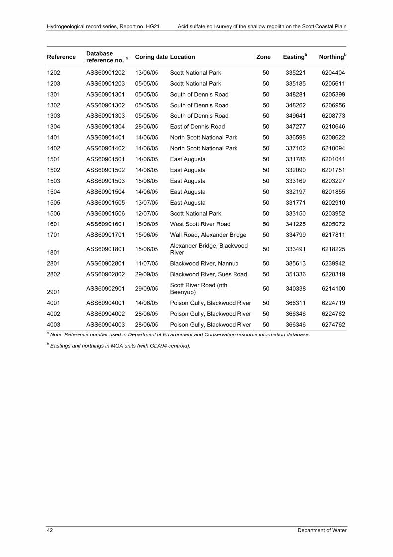
Hydrogeological record series, Report no. HG24 Acid sulfate soil survey of the shallow regolith on the Scott Coastal Plain
42 Department of Water
Reference Database reference no. a
Coring date Location Zone Eastingb Northingb
1202 ASS60901202 13/06/05 Scott National Park 50 335221 6204404
1203 ASS60901203 05/05/05 Scott National Park 50 335185 6205611
1301 ASS60901301 05/05/05 South of Dennis Road 50 348281 6205399
1302 ASS60901302 05/05/05 South of Dennis Road 50 348262 6206956
1303 ASS60901303 05/05/05 South of Dennis Road 50 349641 6208773
1304 ASS60901304 28/06/05 East of Dennis Road 50 347277 6210646
1401 ASS60901401 14/06/05 North Scott National Park 50 336598 6208622
1402 ASS60901402 14/06/05 North Scott National Park 50 337102 6210094
1501 ASS60901501 14/06/05 East Augusta 50 331786 6201041
1502 ASS60901502 14/06/05 East Augusta 50 332090 6201751
1503 ASS60901503 15/06/05 East Augusta 50 333169 6203227
1504 ASS60901504 14/06/05 East Augusta 50 332197 6201855
1505 ASS60901505 13/07/05 East Augusta 50 331771 6202910
1506 ASS60901506 12/07/05 Scott National Park 50 333150 6203952
1601 ASS60901601 15/06/05 West Scott River Road 50 341225 6205072
1701 ASS60901701 15/06/05 Wall Road, Alexander Bridge 50 334799 6217811
1801 ASS60901801 15/06/05
Alexander Bridge, Blackwood River
50 333491 6218225
2801 ASS60902801 11/07/05 Blackwood River, Nannup 50 385613 6239942
2802 ASS60902802 29/09/05 Blackwood River, Sues Road 50 351336 6228319
2901 ASS60902901 29/09/05
Scott River Road (nth Beenyup)
50 340338 6214100
4001 ASS60904001 14/06/05 Poison Gully, Blackwood River 50 366311 6224719
4002 ASS60904002 28/06/05 Poison Gully, Blackwood River 50 366346 6224762
4003 ASS60904003 28/06/05 Poison Gully, Blackwood River 50 366346 6274762a Note: Reference number used in Department of Environment and Conservation resource information database.
b Eastings and northings in MGA units (with GDA94 centroid).
Acid sulfate soil survey of the shallow regolith on the Scott Coastal Plain Hydrogeological record series, Report no. HG24
Department of Water 43
Appendix 2: DEC Contaminated Sites Branch (previously Land and Water Quality Branch) acid sulfate soil field methods
Objectives
The objective of these sampling methods is to provide a standard that can be used state-wide, to enable a sampling and analysis regime that will provide an accurate assessment of environmental impact prior to disturbance of acid sulfate soils (ASS) and potential acid sulfate soils (PASS). The following general guidelines apply:
All field personnel will ensure that investigation of all sites will be conducted with minimum disturbance to fauna and flora.
Where material disturbance occurs, every consideration will be taken to leave the site as near as possible to its original state. Cuttings from site hole augers will be replaced in the hole where investigation has been conducted.
Communicate with all stakeholders during the field program.
Selection of sites
General selection of investigation sites (within 200 m) is determined by the supervising scientist, with finer scale placement (<100 m) determined by field technicians (involving on-site assessment of access and safety issues).
Site information
All information is recorded on standard Land and Water Quality ASS field record sheets.
Information outline The location of each borehole is determined with GPS using the Geocentric Datum
Australia 1994 (GDA94) centroid and reported as Easting and Northing (Metric Grid of Australia).
Map reference sheet name and number, e.g. Perth Environmental Geology 1:50 000 2034 II.
Date/month/year (DD-MM-YYYY).
Approximate surface elevation (AHD), taken from reference topography map.
Landform, e.g. estuarine, lagoon, floodplain, dune.
Dominant vegetation.
Standing groundwater level.
Material profile descriptions
1. Record the method of material extraction, e.g. rotary auger, direct push, hand auger.
2. Confirm the length of the sampling (stainless steel, polycarbonate) rod/tube.
3. Control of horizon measurements is critical in the assessment of the amount of AASS and PASS soils in the profile.
Hydrogeological record series, Report no. HG24 Acid sulfate soil survey of the shallow regolith on the Scott Coastal Plain
44 Department of Water
The following soil profile observations and field measurements must be recorded:
Material horizons and their depths.
Material loss during extraction of sampling rod/tube (i.e. recovery of profile during coring run).
Munsell colours, mottles (including approximate proportion of exposed core area mottled), iron monosulfides, jarosite mottling.
Field texture and structure, e.g. clay, loam, silt – moist, hard, pliable, plastic, organic material.
Visible shell fragments, size and abundance must be recorded before removal for sampling. Test for presence of reactive carbonates using HCl-drop test.
Measurement of field pHF and field pHFOX after oxidation with 30 per cent peroxide (H2O2) should be recorded at 0.25 m or within each soil horizon.
Depth of watertable (mbgl).
Profiling should continue to 1–2 m below the watertable.
Field pH test (pHF)
Procedure outline (adapted from Hey et al, 2000):
1. Calibrate battery powered field pH meter (pH4 – pH7).
2. Test and record the pH value of the deionised water.
3. Prepare the test tubes in the test rack. Make sure the rack is marked with the depths so there is no confusion about the top and bottom profile. Use of separate racks for the pHF and the pHFOX tests is recommended as contamination may occur when the pHFOX reactions become violent.
4. Conduct tests at intervals on the soil profile of 0.25 m or at least one test per horizon whichever is lesser.
5. Remove approximately 1 teaspoon of soil from the profile. Place approximately ½ teaspoon of the soil into the pHF test tube and place the other ½ teaspoon of the soil into the pHFOX test tube for the corresponding depth test. It is important that these two subsamples are taken from the same depth and that they are similar in characteristics.
6. Place enough deionised water (~pH 5.5) in the test tube to make a paste similar to a ‘grout mix’, stirring with a skewer or similar to ensure all lumps are removed. Do not leave the sample in the test tube without water for longer than 10 minutes. This will reduce the risk of oxidation – the pHF is designed to measure acidity, any oxidation subsequent to the soil’s removal from the ground will not reflect the true situation. In some instances, in less than five minutes, monosulfidic material may start to oxidise and substantially affect the pHF results.
7. Immediately place the spear point electrode (preferred method) into the test tube, ensuring that the spear point is totally submerged in the soil/water paste. Never stir the paste with the electrode. This will damage the semi-permeable glass membrane.
8. Measure the pHF using the pH meter with the spear point probe.
9. Wait for the reading to stabilise and record the pH measurement. All measurements should be recorded on a data sheet.
Acid sulfate soil survey of the shallow regolith on the Scott Coastal Plain Hydrogeological record series, Report no. HG24
Department of Water 45
pH value Result Comments
pHF ≤4 Actual acid sulfate soils (AASS) indicating oxidation of sulfides
This is generally not conclusive but highly organic soils such as peat and occasionally heavily fertilised soils may also give pHF ≤4.
pHF ≤3.7 Expected if jarosite exists in the sample
This is indicative of an actual ASS layer. Jarosite needs a pH of at least 3.7 to form. Horizons containing some jarosite and some other mottling (iron, grey) may have a pH >3.7 if the sample contains a mixture of jarosite and higher pH soil. This depends on the level of oxidation and the ability of the soil to retain any soluble acidity arising from oxidation of PASS materials.
pHF ≥7 Expected in waterlogged, unoxidised, or poorly drained soils
Marine mud commonly has a pH >7 and reflects seawater (pH 8.2) influence, although carbonate-rich profiles can also be at this pH. May contain PASS materials.
pHF >4,≤5.5 A strongly acid soil Investigate further for possible ASS link, e.g. actual ASS materials with shells/carbonates present.
Field pH peroxide test (pHFOX)
The pH and strength of peroxide used is important. The pH of the peroxide should be pH 4.5–5.5 (ideally pH 5.5). This ensures that the result measured is a reflection of the oxidation of the soil (if any) and not of the existing pH of the peroxide. When peroxide is purchased often the phosphoric acid stabilisers added by the chemical companies will result in a pH of approximately 2–3. This pH can be increased by adding small amounts of sodium hydroxide (NaOH) (refer to Health and Safety data sheet for 30 per cent peroxide). Failure to adjust the pH can lead to false field peroxide test results.
Any chemicals used for field programs should not be exposed to lengthy periods in sunlight. They should be stored in such a manner that does not submit them to extreme temperature changes. Peroxide also requires regular venting to evacuate build-up of oxygen and hydrogen gases in the headspace of the storage bottle. A small pinhole in the lid will facilitate this process.
Procedure outline 1. Adjust the pH of the hydrogen peroxide before going into the field. This can be
achieved by adding a few drops of concentrated NaOH (general laboratory grade) at a time and checking the pH with the electrode regularly. Concentrated NaOH solution is highly caustic and safety precautions must be exercised. Also, NaOH will raise the pH quickly so the pH needs to be regularly checked during this process. DO NOT buffer a large quantity of hydrogen peroxide at one time since the acid preservative maintains the stability of the peroxide. Only buffer the amount to be used in the field, storing the remaining in darkness at 5ºC in a well-labelled container with only small quantities to be taken into the field at one time. It is recommended that the pH-adjusted peroxide solution used for field testing is stored in a dark, shatter-proof container that prevents light penetration and in such a manner that does not submit the container to extreme temperature conditions. The pH of the peroxide that has already been buffered may change over time and must be measured (and corrected, if necessary) prior to use in the field as part of QA/QC requirements (only once at the beginning of each field work day is necessary). It is recommended that a small quantity of concentrated NaOH is kept with the field test kit so the peroxide can be buffered if needed.
2. Calibrate battery powered field pH meter and record the measured calibration. Records of the probe calibration give the field officer an indicator of the life of the

Hydrogeological record series, Report no. HG24 Acid sulfate soil survey of the shallow regolith on the Scott Coastal Plain
46 Department of Water
probe. The peroxide can be particularly aggressive to semi-permeable glass-membrane-tipped spear point probes.
3. Prepare the test tubes in the test rack as for pHF test. Make sure the rack is marked with the depths so there is no confusion about the top and bottom profile. Use of separate racks for the pHF and the pHFOX tests is recommended as contamination may occur when the pHFOX reactions are violent.
4. Conduct pHF tests at intervals on the soil from the profile of 0.25 m or at least one per horizon whichever is the lesser.
5. Remove approximately 1 teaspoon from the profile. Place approximately ½ teaspoon of that soil into the pHF test tube and place ½ teaspoon of soil into the pHFOX test tube. It is important that these two subsamples come from the same depth and that they are similar in characteristics. DO NOT TAKE SAMPLES FROM OBVIOUSLY DIFFERENT SOIL TYPES. These will give different results from the type of test conducted.
6. Remove any large shell and/or limestone fragments from the material before testing. If unsure about material buffering capacity, use a few drops of 10 per cent HCl to verify the presence of carbonates in material. If carbonates are present a fizzy bubbling reaction will occur. HCl should be carried in a glass bottle with eye dropper. It should be safely and securely in the vehicle, clearly identified for its harmful potential.
7. Add a few drops of 30 per cent H2O2 adjusted to pH 4.5–5.5 to the soil in a heat-resistant test tube and stir the mixture. For soil horizons that have a substantial amount of organic material DO NOT add more than a few drops at a time. This will prevent overflow and wastage of peroxide. A day’s supply of peroxide should be allowed to reach ambient temperature prior to use.
8. Ideally allow no less than 15 minutes for any reactions to occur. If substantial PASS materials are present, the reaction will be vigorous and may occur almost instantly. Careful watch will be needed in the early stage to ensure that there is no cross contamination of the sample in the test rack. If the reaction is violent and the soil/peroxide mixture is escaping from the test tube, a small amount of deionised water can be added to cool and calm the reaction. DO NOT add too much deionised water as this may dilute the mixture and affect the pH value.
9. Steps 6 and 7 may be repeated until the soil/peroxide mixture reaction has slowed. This will ensure that most of the sulfides have reacted.
10. If there is no initial reaction, individual test tubes containing the soil/peroxide mixture can be placed into a cup of hot water (especially in cooler weather) or in direct sunlight. This will encourage the initial reaction to occur. When the sample starts to ‘bubble’, remove the test tube immediately from the cup and replace into test tube rack.
11. Rate the reaction using the scale:
L Slight effervescence (generally small bubbles, reaction jar warmer than equivalent pHF test jar)
M Moderate reaction (large bubbles, contained within reaction jar for duration of test, reaction jar is warm to hot)
H High reaction (large bubbles, foaming over the top of reaction jars often in continuous stream, reaction jar is warm to hot)
X Volcanic (very vigorous, violent, spitting, with a gas given off, reaction jar is hot)
Acid sulfate soil survey of the shallow regolith on the Scott Coastal Plain Hydrogeological record series, Report no. HG24
Department of Water 47
12. Wait for the soil/peroxide mixture to cool (may take up to 10 minutes). The reactions often exceed 90ºC. Placing an electrode into these high temperature situations may result in physical damage and inaccurate readings as most pH meters are calibrated to record a result for an ambient temperature of approximately 25ºC.
13. Measure the pHFOX with an electronic meter. Place the spear point probe electrode into the test tube, ensuring that the spear point is totally submerged in the soil/peroxide mixture. NEVER STIR the mixture with the electrode. This will damage the semi-permeable glass membrane.
14. Wait for pH reading to stabilise and record the pHFOX measurement.
15. Record all measurements on a field data sheet.
Material sampling Samples should be taken every 0.5 m, or every material horizon, whichever is greater
or lesser.
Each sample should be greater than 200 g (more than half the sample bag supplied).
Any visible shell fragments should be removed from the sample in the field. If shell is not removed, it will bias laboratory results by overestimating the buffering capacity of the soil.
Sample bags should be labelled externally, detailing site name and sample depth. Waterproof labels can be inserted in the bag detailing the site name and depth, although the laboratory will need to be made aware of these prior to sample processing.
Samples should be placed in a plastic snap-lock bag: as much air as possible should be evacuated from the sample bag before sealing.
Immediately freeze sample bags in a portable fridge (e.g. 12V ENGEL fridge).
A register of all samples should be kept.
Duplicate samples should be taken every 20 samples. Labelling and numbering of duplicates should continue as the convention set for the labelling of all other samples.
The cleaning of sampling equipment is essential between each sampling horizon to avoid cross-contamination of samples.
DO NOT LEAVE ANY POTENTIAL ACID SULFATE SOILS EXPOSED AT A SAMPLING SITE.
All samples are returned to deep frozen storage in Perth. Samples assessed for laboratory analysis are submitted in bulk batches to laboratory.
If several sampling horizons from one hole are to be sent they should be grouped and placed in a larger bag.
All samples for analysis with analytical suite must be recorded on DEC chain-of-custody sheets to accompany sample to laboratory.
Cuttings of all horizons to be collected in chip trays clearly identified with site name/number and depth of horizon.
Quality control and quality assurance Calibration of pH meter is checked (and adjusted if necessary) at the beginning and
end of each day (further details below). Periodic rechecking of calibration is conducted when samples have sudden low or high pH readings in a soil profile compared with
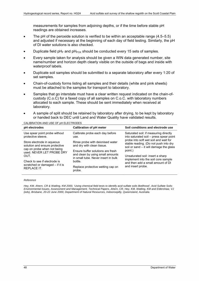
Hydrogeological record series, Report no. HG24 Acid sulfate soil survey of the shallow regolith on the Scott Coastal Plain
48 Department of Water
measurements for samples from adjoining depths, or if the time before stable pH readings are obtained increases.
The pH of the peroxide solution is verified to be within an acceptable range (4.5–5.5) and adjusted if necessary at the beginning of each day of field testing. Similarly, the pH of DI water solutions is also checked.
Duplicate field pHF and pHFOX should be conducted every 15 sets of samples.
Every sample taken for analysis should be given a WIN data generated number, site name/number and horizon depth clearly visible on the outside of bags and inside with waterproof labels.
Duplicate soil samples should be submitted to a separate laboratory after every 1:20 of set samples.
Chain-of-custody forms listing all samples and their details (white and pink sheets) must be attached to the samples for transport to laboratory.
Samples that go interstate must have a clear written request indicated on the chain-of-custody (C.o.C) for a faxed copy of all samples on C.o.C. with laboratory numbers allocated to each sample. These should be sent immediately when received at laboratory.
A sample of split should be retained by laboratory after drying, to be kept by laboratory or handed back to DEC until Land and Water Quality have validated results.
CALIBRATION AND USE OF pH ELECTRODES
pH electrodes Calibration of pH meter Soil conditions and electrode use
Use spear point probe without protective sleeve.
Store electrode in aqueous solution and ensure protective cap on probe when not being used. NEVER LET PROBE DRY OUT.
Check to see if electrode is scratched or damaged – if it is REPLACE IT.
Calibrate probe each day before use.
Rinse probe with deionised water and dry with clean tissue.
Ensure buffer solutions are fresh and clean by using small amounts in small tube. Never insert in bulk bottle.
Replace protective wetting cap on probe.
Saturated soil: if measuring directly into saturated soil – press spear point probe into soft wet soil and wait for stable reading. (Do not push into dry soil or sand – it will damage the glass point.)
Unsaturated soil: insert a sharp implement into the soil core sample and then add a small amount of DI and insert probe.
Reference
Hey, KM, Ahern, CR & Watling, KM 2000, ‘Using chemical field tests to identify acid sulfate soils likelihood’, Acid Sulfate Soils: Environmental Issues, Assessment and Management, Technical Papers, Ahern, CR, Hey, KM, Watling, KM and Eldershaw, VJ (eds), Brisbane, 20-22 June 2000, Department of Natural Resources, Indooroopilly, Queensland, Australia.
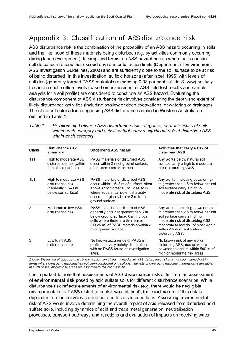
Acid sulfate soil survey of the shallow regolith on the Scott Coastal Plain Hydrogeological record series, Report no. HG24
Department of Water 49
Appendix 3: Classification of ASS disturbance risk ASS disturbance risk is the combination of the probability of an ASS hazard occurring in soils and the likelihood of these materials being disturbed (e.g. by activities commonly occurring during land development). In simplified terms, an ASS hazard occurs where soils contain sulfide concentrations that exceed environmental action limits (Department of Environment, ASS Investigation Guidelines, 2003) and are sufficiently close to the soil surface to be at risk of being disturbed. In this investigation, sulfidic horizons (after Isbell 1996) with levels of sulfides (generally termed PASS materials) exceeding 0.03 per cent sulfide-S (w/w) or likely to contain such sulfide levels (based on assessment of ASS field test results and sample analysis for a soil profile) are considered to constitute an ASS hazard. Evaluating the disturbance component of ASS disturbance risk involves considering the depth and extent of likely disturbance activities (including shallow or deep excavations, dewatering or drainage). The standard criteria for categorising ASS disturbance applied in Western Australia are outlined in Table 1.
Table 1: Relationship between ASS disturbance risk categories, characteristics of soils within each category and activities that carry a significant risk of disturbing ASS within each category
Class Disturbance risk summary
Underlying ASS hazard Activities that carry a risk of disturbing ASS
1a1 High to moderate ASS disturbance risk (within 2 m of soil surface)
PASS materials or disturbed ASS occur within 2 m of ground surface, often above action criteria.
Any works below natural soil surface carry a high to moderate risk of disturbing ASS.
1b1 High to moderate ASS disturbance risk (generally 1.5–3 m below soil surface)
PASS materials or disturbed ASS occur within 1.5–3 m of surface, often above action criteria. Includes soils where substantial potential acidity occurs marginally below 3 m from ground surface.
Any works (including dewatering) to greater than 1.5 m below natural soil surface carry a high to moderate risk of disturbing ASS.
2 Moderate to low ASS disturbance risk
PASS materials or disturbed ASS generally occur at greater than 3 m below ground surface. Can include soils where there are thin lenses (<0.25 m) of PASS materials within 3 m of ground surface.
Any works (including dewatering) to greater than 2.5 m below natural soil surface carry a high to moderate risk of disturbing ASS. Moderate to low risk of most works within 2.5 m of soil surface disturbing ASS.
3 Low to nil ASS disturbance risk
No known occurrence of PASS in profiles, or very patchy distribution with no PASS found at investigation sites.
No known risk of any works disturbing ASS, except where dewatering occurs within 500 m of high or moderate risk areas.
1 Note: Distinction of class 1a and 1b in classification of high to moderate ASS disturbance risk has not been carried out in areas where on-ground mapping has not been conducted or insufficient density of on-ground mapping information is available. In such cases, all high-risk areas are assumed to fall into class 1a.
It is important to note that assessments of ASS disturbance risk differ from an assessment of environmental risk posed by acid sulfate soils for different disturbance scenarios. While disturbance risk reflects elements of environmental risk (e.g. there would be negligible environmental risk if ASS disturbance risk was minimal), the exact nature of this risk is dependent on the activities carried out and local site conditions. Assessing environmental risk of ASS would involve determining the overall impact of acid released from disturbed acid sulfate soils, including dynamics of acid and trace metal generation, neutralisation processes, transport pathways and reactions and evaluation of impacts on receiving water

Hydrogeological record series, Report no. HG24 Acid sulfate soil survey of the shallow regolith on the Scott Coastal Plain
50 Department of Water
ecosystems (surface water and groundwater) and infrastructure. Individual characteristics of sites, the differences in how the disturbance is carried out and climatic conditions prevent generalised assessment of environmental risk of acid sulfate soil disturbance. This level of evaluation is achieved through statutory requirements for proponents managing areas with acid sulfate soils to carry out site-specific investigations of acid sulfate soils and prepare management plans prior to disturbing ASS.
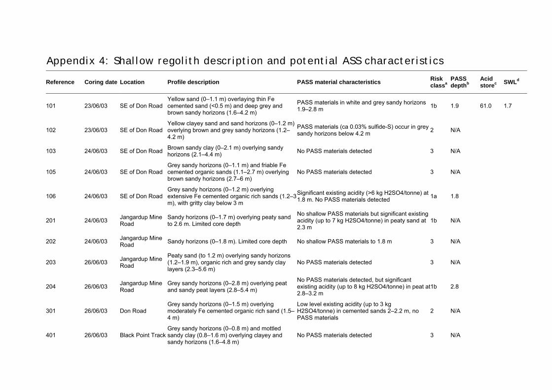
Appendix 4: Shallow regolith description and potential ASS characteristics
Reference Coring date Location Profile description PASS material characteristics Risk classa
PASS depthb
Acid storec
SWLd
101 23/06/03 SE of Don Road Yellow sand (0–1.1 m) overlaying thin Fe cemented sand (<0.5 m) and deep grey and brown sandy horizons (1.6–4.2 m)
PASS materials in white and grey sandy horizons 1.9–2.8 m
1b 1.9 61.0 1.7
102 23/06/03 SE of Don Road Yellow clayey sand and sand horizons (0–1.2 m) overlying brown and grey sandy horizons (1.2–4.2 m)
PASS materials (ca 0.03% sulfide-S) occur in grey sandy horizons below 4.2 m
2 N/A
103 24/06/03 SE of Don Road Brown sandy clay (0–2.1 m) overlying sandy horizons (2.1–4.4 m)
No PASS materials detected 3 N/A
105 24/06/03 SE of Don Road Grey sandy horizons (0–1.1 m) and friable Fe cemented organic sands (1.1–2.7 m) overlying brown sandy horizons (2.7–6 m)
No PASS materials detected 3 N/A
106 24/06/03 SE of Don Road Grey sandy horizons (0–1.2 m) overlying extensive Fe cemented organic rich sands (1.2–3 m), with gritty clay below 3 m
Significant existing acidity (>6 kg H2SO4/tonne) at 1.8 m. No PASS materials detected
1a 1.8
201 24/06/03 Jangardup Mine Road
Sandy horizons (0–1.7 m) overlying peaty sand to 2.6 m. Limited core depth
No shallow PASS materials but significant existing acidity (up to 7 kg H2SO4/tonne) in peaty sand at 2.3 m
1b N/A
202 24/06/03 Jangardup Mine Road
Sandy horizons (0–1.8 m). Limited core depth No shallow PASS materials to 1.8 m 3 N/A
203 26/06/03 Jangardup Mine Road
Peaty sand (to 1.2 m) overlying sandy horizons (1.2–1.9 m), organic rich and grey sandy clay layers (2.3–5.6 m)
No PASS materials detected 3 N/A
204 26/06/03 Jangardup Mine Road
Grey sandy horizons (0–2.8 m) overlying peat and sandy peat layers (2.8–5.4 m)
No PASS materials detected, but significant existing acidity (up to 8 kg H2SO4/tonne) in peat at 2.8–3.2 m
1b 2.8
301 26/06/03 Don Road Grey sandy horizons (0–1.5 m) overlying moderately Fe cemented organic rich sand (1.5–4 m)
Low level existing acidity (up to 3 kg H2SO4/tonne) in cemented sands 2–2.2 m, no PASS materials
2 N/A
401 26/06/03 Black Point TrackGrey sandy horizons (0–0.8 m) and mottled sandy clay (0.8–1.6 m) overlying clayey and sandy horizons (1.6–4.8 m)
No PASS materials detected 3 N/A
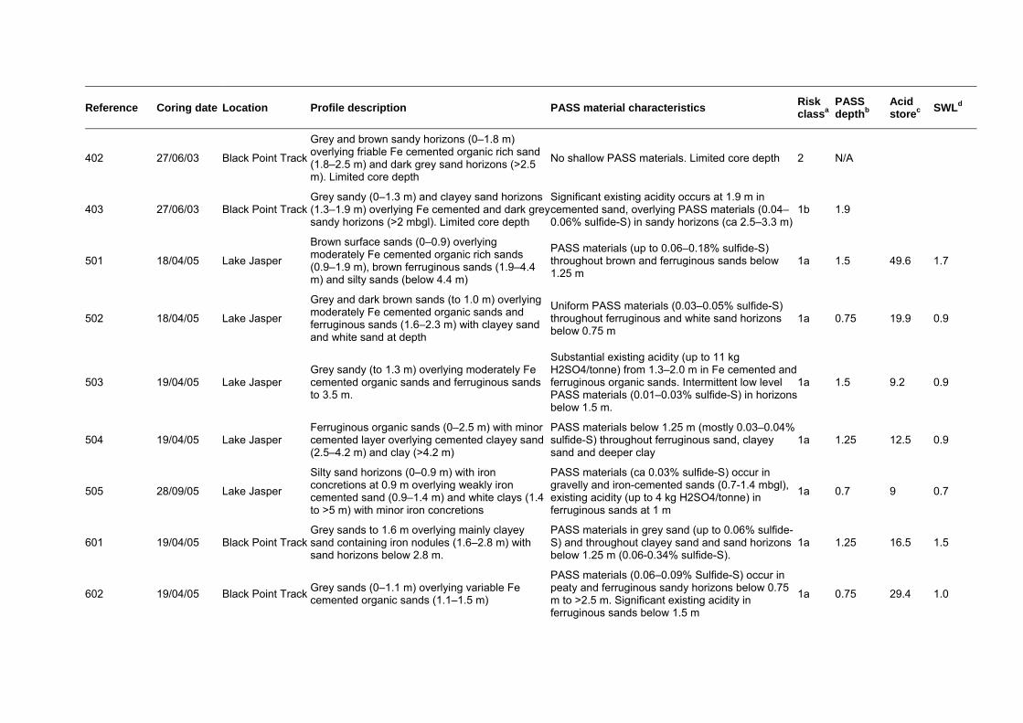
Reference Coring date Location Profile description PASS material characteristics Risk classa
PASS depthb
Acid storec
SWLd
402 27/06/03 Black Point Track
Grey and brown sandy horizons (0–1.8 m) overlying friable Fe cemented organic rich sand (1.8–2.5 m) and dark grey sand horizons (>2.5 m). Limited core depth
No shallow PASS materials. Limited core depth 2 N/A
403 27/06/03 Black Point TrackGrey sandy (0–1.3 m) and clayey sand horizons (1.3–1.9 m) overlying Fe cemented and dark grey sandy horizons (>2 mbgl). Limited core depth
Significant existing acidity occurs at 1.9 m in cemented sand, overlying PASS materials (0.04–0.06% sulfide-S) in sandy horizons (ca 2.5–3.3 m)
1b 1.9
501 18/04/05 Lake Jasper
Brown surface sands (0–0.9) overlying moderately Fe cemented organic rich sands (0.9–1.9 m), brown ferruginous sands (1.9–4.4 m) and silty sands (below 4.4 m)
PASS materials (up to 0.06–0.18% sulfide-S) throughout brown and ferruginous sands below 1.25 m
1a 1.5 49.6 1.7
502 18/04/05 Lake Jasper
Grey and dark brown sands (to 1.0 m) overlying moderately Fe cemented organic sands and ferruginous sands (1.6–2.3 m) with clayey sand and white sand at depth
Uniform PASS materials (0.03–0.05% sulfide-S) throughout ferruginous and white sand horizons below 0.75 m
1a 0.75 19.9 0.9
503 19/04/05 Lake Jasper Grey sandy (to 1.3 m) overlying moderately Fe cemented organic sands and ferruginous sands to 3.5 m.
Substantial existing acidity (up to 11 kg H2SO4/tonne) from 1.3–2.0 m in Fe cemented and ferruginous organic sands. Intermittent low level PASS materials (0.01–0.03% sulfide-S) in horizons below 1.5 m.
1a 1.5 9.2 0.9
504 19/04/05 Lake Jasper Ferruginous organic sands (0–2.5 m) with minor cemented layer overlying cemented clayey sand (2.5–4.2 m) and clay (>4.2 m)
PASS materials below 1.25 m (mostly 0.03–0.04% sulfide-S) throughout ferruginous sand, clayey sand and deeper clay
1a 1.25 12.5 0.9
505 28/09/05 Lake Jasper
Silty sand horizons (0–0.9 m) with iron concretions at 0.9 m overlying weakly iron cemented sand (0.9–1.4 m) and white clays (1.4 to >5 m) with minor iron concretions
PASS materials (ca 0.03% sulfide-S) occur in gravelly and iron-cemented sands (0.7-1.4 mbgl), existing acidity (up to 4 kg H2SO4/tonne) in ferruginous sands at 1 m
1a 0.7 9 0.7
601 19/04/05 Black Point TrackGrey sands to 1.6 m overlying mainly clayey sand containing iron nodules (1.6–2.8 m) with sand horizons below 2.8 m.
PASS materials in grey sand (up to 0.06% sulfide-S) and throughout clayey sand and sand horizons below 1.25 m (0.06-0.34% sulfide-S).
1a 1.25 16.5 1.5
602 19/04/05 Black Point TrackGrey sands (0–1.1 m) overlying variable Fe cemented organic sands (1.1–1.5 m)
PASS materials (0.06–0.09% Sulfide-S) occur in peaty and ferruginous sandy horizons below 0.75 m to >2.5 m. Significant existing acidity in ferruginous sands below 1.5 m
1a 0.75 29.4 1.0
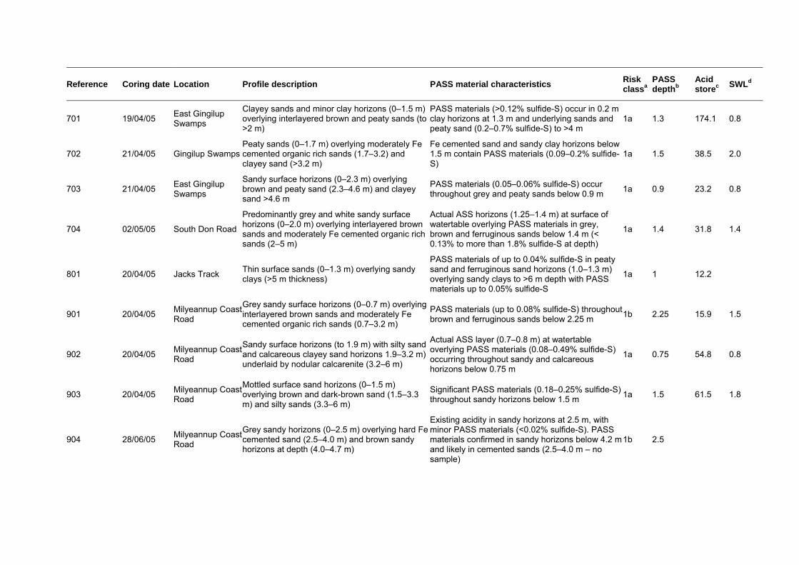
Reference Coring date Location Profile description PASS material characteristics Risk classa
PASS depthb
Acid storec
SWLd
701 19/04/05 East Gingilup Swamps
Clayey sands and minor clay horizons (0–1.5 m) overlying interlayered brown and peaty sands (to >2 m)
PASS materials (>0.12% sulfide-S) occur in 0.2 m clay horizons at 1.3 m and underlying sands and peaty sand (0.2–0.7% sulfide-S) to >4 m
1a 1.3 174.1 0.8
702 21/04/05 Gingilup SwampsPeaty sands (0–1.7 m) overlying moderately Fe cemented organic rich sands (1.7–3.2) and clayey sand (>3.2 m)
Fe cemented sand and sandy clay horizons below 1.5 m contain PASS materials (0.09–0.2% sulfide-S)
1a 1.5 38.5 2.0
703 21/04/05 East Gingilup Swamps
Sandy surface horizons (0–2.3 m) overlying brown and peaty sand (2.3–4.6 m) and clayey sand >4.6 m
PASS materials (0.05–0.06% sulfide-S) occur throughout grey and peaty sands below 0.9 m
1a 0.9 23.2 0.8
704 02/05/05 South Don Road
Predominantly grey and white sandy surface horizons (0–2.0 m) overlying interlayered brown sands and moderately Fe cemented organic rich sands (2–5 m)
Actual ASS horizons (1.25–1.4 m) at surface of watertable overlying PASS materials in grey, brown and ferruginous sands below 1.4 m (< 0.13% to more than 1.8% sulfide-S at depth)
1a 1.4 31.8 1.4
801 20/04/05 Jacks Track Thin surface sands (0–1.3 m) overlying sandy clays (>5 m thickness)
PASS materials of up to 0.04% sulfide-S in peaty sand and ferruginous sand horizons (1.0–1.3 m) overlying sandy clays to >6 m depth with PASS materials up to 0.05% sulfide-S
1a 1 12.2
901 20/04/05 Milyeannup Coast Road
Grey sandy surface horizons (0–0.7 m) overlying interlayered brown sands and moderately Fe cemented organic rich sands (0.7–3.2 m)
PASS materials (up to 0.08% sulfide-S) throughout brown and ferruginous sands below 2.25 m
1b 2.25 15.9 1.5
902 20/04/05 Milyeannup Coast Road
Sandy surface horizons (to 1.9 m) with silty sand and calcareous clayey sand horizons 1.9–3.2 m) underlaid by nodular calcarenite (3.2–6 m)
Actual ASS layer (0.7–0.8 m) at watertable overlying PASS materials (0.08–0.49% sulfide-S) occurring throughout sandy and calcareous horizons below 0.75 m
1a 0.75 54.8 0.8
903 20/04/05 Milyeannup Coast Road
Mottled surface sand horizons (0–1.5 m) overlying brown and dark-brown sand (1.5–3.3 m) and silty sands (3.3–6 m)
Significant PASS materials (0.18–0.25% sulfide-S) throughout sandy horizons below 1.5 m
1a 1.5 61.5 1.8
904 28/06/05 Milyeannup Coast Road
Grey sandy horizons (0–2.5 m) overlying hard Fe cemented sand (2.5–4.0 m) and brown sandy horizons at depth (4.0–4.7 m)
Existing acidity in sandy horizons at 2.5 m, with minor PASS materials (<0.02% sulfide-S). PASS materials confirmed in sandy horizons below 4.2 m and likely in cemented sands (2.5–4.0 m – no sample)
1b 2.5
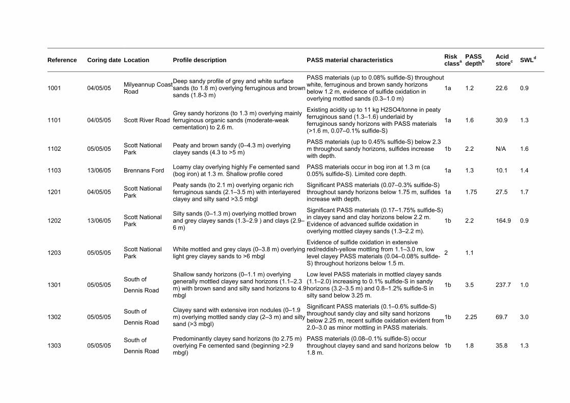
Reference Coring date Location Profile description PASS material characteristics Risk classa
PASS depthb
Acid storec
SWLd
1001 04/05/05 Milyeannup Coast Road
Deep sandy profile of grey and white surface sands (to 1.8 m) overlying ferruginous and brown sands (1.8-3 m)
PASS materials (up to 0.08% sulfide-S) throughout white, ferruginous and brown sandy horizons below 1.2 m, evidence of sulfide oxidation in overlying mottled sands (0.3–1.0 m)
1a 1.2 22.6 0.9
1101 04/05/05 Scott River RoadGrey sandy horizons (to 1.3 m) overlying mainly ferruginous organic sands (moderate-weak cementation) to 2.6 m.
Existing acidity up to 11 kg H2SO4/tonne in peaty ferruginous sand (1.3–1.6) underlaid by ferruginous sandy horizons with PASS materials (>1.6 m, 0.07–0.1% sulfide-S)
1a 1.6 30.9 1.3
1102 05/05/05 Scott National Park
Peaty and brown sandy (0–4.3 m) overlying clayey sands (4.3 to >5 m)
PASS materials (up to 0.45% sulfide-S) below 2.3 m throughout sandy horizons, sulfides increase with depth.
1b 2.2 N/A 1.6
1103 13/06/05 Brennans Ford Loamy clay overlying highly Fe cemented sand (bog iron) at 1.3 m. Shallow profile cored
PASS materials occur in bog iron at 1.3 m (ca 0.05% sulfide-S). Limited core depth.
1a 1.3 10.1 1.4
1201 04/05/05 Scott National Park
Peaty sands (to 2.1 m) overlying organic rich ferruginous sands (2.1–3.5 m) with interlayered clayey and silty sand >3.5 mbgl
Significant PASS materials (0.07–0.3% sulfide-S) throughout sandy horizons below 1.75 m, sulfides increase with depth.
1a 1.75 27.5 1.7
1202 13/06/05 Scott National Park
Silty sands (0–1.3 m) overlying mottled brown and grey clayey sands (1.3–2.9 ) and clays (2.9–6 m)
Significant PASS materials (0.17–1.75% sulfide-S) in clayey sand and clay horizons below 2.2 m. Evidence of advanced sulfide oxidation in overlying mottled clayey sands (1.3–2.2 m).
1b 2.2 164.9 0.9
1203 05/05/05 Scott National Park
White mottled and grey clays (0–3.8 m) overlying light grey clayey sands to >6 mbgl
Evidence of sulfide oxidation in extensive red/reddish-yellow mottling from 1.1–3.0 m, low level clayey PASS materials (0.04–0.08% sulfide-S) throughout horizons below 1.5 m.
2 1.1
1301 05/05/05 South of
Dennis Road
Shallow sandy horizons (0–1.1 m) overlying generally mottled clayey sand horizons (1.1–2.3 m) with brown sand and silty sand horizons to 4.9 mbgl
Low level PASS materials in mottled clayey sands (1.1–2.0) increasing to 0.1% sulfide-S in sandy horizons (3.2–3.5 m) and 0.8–1.2% sulfide-S in silty sand below 3.25 m.
1b 3.5 237.7 1.0
1302 05/05/05 South of
Dennis Road
Clayey sand with extensive iron nodules (0–1.9 m) overlying mottled sandy clay (2–3 m) and silty sand (>3 mbgl)
Significant PASS materials (0.1–0.6% sulfide-S) throughout sandy clay and silty sand horizons below 2.25 m, recent sulfide oxidation evident from 2.0–3.0 as minor mottling in PASS materials.
1b 2.25 69.7 3.0
1303 05/05/05 South of
Dennis Road
Predominantly clayey sand horizons (to 2.75 m) overlying Fe cemented sand (beginning >2.9 mbgl)
PASS materials (0.08–0.1% sulfide-S) occur throughout clayey sand and sand horizons below 1.8 m.
1b 1.8 35.8 1.3
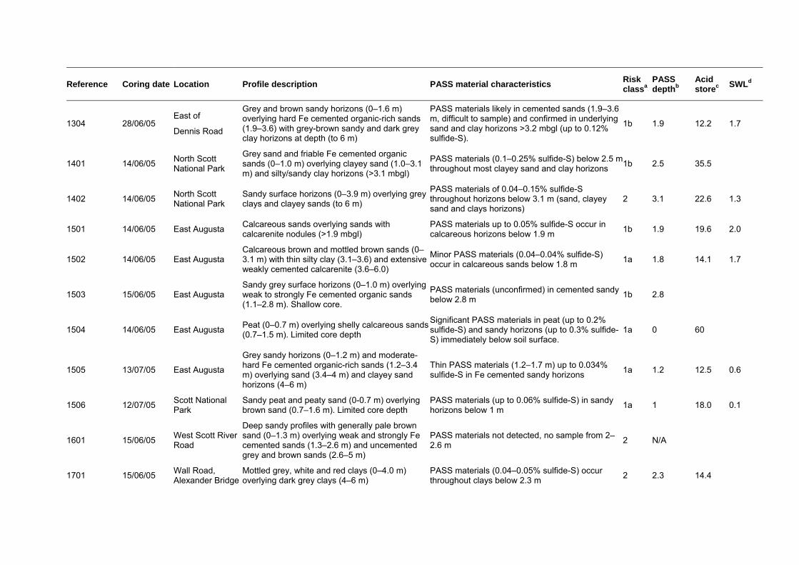
Reference Coring date Location Profile description PASS material characteristics Risk classa
PASS depthb
Acid storec
SWLd
1304 28/06/05 East of
Dennis Road
Grey and brown sandy horizons (0–1.6 m) overlying hard Fe cemented organic-rich sands (1.9–3.6) with grey-brown sandy and dark grey clay horizons at depth (to 6 m)
PASS materials likely in cemented sands (1.9–3.6 m, difficult to sample) and confirmed in underlying sand and clay horizons >3.2 mbgl (up to 0.12% sulfide-S).
1b 1.9 12.2 1.7
1401 14/06/05 North Scott National Park
Grey sand and friable Fe cemented organic sands (0–1.0 m) overlying clayey sand (1.0–3.1 m) and silty/sandy clay horizons (>3.1 mbgl)
PASS materials (0.1–0.25% sulfide-S) below 2.5 m throughout most clayey sand and clay horizons
1b 2.5 35.5
1402 14/06/05 North Scott National Park
Sandy surface horizons (0–3.9 m) overlying grey clays and clayey sands (to 6 m)
PASS materials of 0.04–0.15% sulfide-S throughout horizons below 3.1 m (sand, clayey sand and clays horizons)
2 3.1 22.6 1.3
1501 14/06/05 East Augusta Calcareous sands overlying sands with calcarenite nodules (>1.9 mbgl)
PASS materials up to 0.05% sulfide-S occur in calcareous horizons below 1.9 m
1b 1.9 19.6 2.0
1502 14/06/05 East Augusta Calcareous brown and mottled brown sands (0–3.1 m) with thin silty clay (3.1–3.6) and extensive weakly cemented calcarenite (3.6–6.0)
Minor PASS materials (0.04–0.04% sulfide-S) occur in calcareous sands below 1.8 m
1a 1.8 14.1 1.7
1503 15/06/05 East Augusta Sandy grey surface horizons (0–1.0 m) overlying weak to strongly Fe cemented organic sands (1.1–2.8 m). Shallow core.
PASS materials (unconfirmed) in cemented sandy below 2.8 m
1b 2.8
1504 14/06/05 East Augusta Peat (0–0.7 m) overlying shelly calcareous sands (0.7–1.5 m). Limited core depth
Significant PASS materials in peat (up to 0.2% sulfide-S) and sandy horizons (up to 0.3% sulfide-S) immediately below soil surface.
1a 0 60
1505 13/07/05 East Augusta
Grey sandy horizons (0–1.2 m) and moderate-hard Fe cemented organic-rich sands (1.2–3.4 m) overlying sand (3.4–4 m) and clayey sand horizons (4–6 m)
Thin PASS materials (1.2–1.7 m) up to 0.034% sulfide-S in Fe cemented sandy horizons
1a 1.2 12.5 0.6
1506 12/07/05 Scott National Park
Sandy peat and peaty sand (0-0.7 m) overlying brown sand (0.7–1.6 m). Limited core depth
PASS materials (up to 0.06% sulfide-S) in sandy horizons below 1 m
1a 1 18.0 0.1
1601 15/06/05 West Scott River Road
Deep sandy profiles with generally pale brown sand (0–1.3 m) overlying weak and strongly Fe cemented sands (1.3–2.6 m) and uncemented grey and brown sands (2.6–5 m)
PASS materials not detected, no sample from 2–2.6 m
2 N/A
1701 15/06/05 Wall Road, Alexander Bridge
Mottled grey, white and red clays (0–4.0 m) overlying dark grey clays (4–6 m)
PASS materials (0.04–0.05% sulfide-S) occur throughout clays below 2.3 m
2 2.3 14.4

Reference Coring date Location Profile description PASS material characteristics Risk classa
PASS depthb
Acid storec
SWLd
1801 15/06/05 Alexander Bridge, Blackwood River
Surface clayey sand, loam and clayey silt (0–1.3 m) overlying mottled grey clay and silty clay (1.3–2.4) and grey silty clay and silty sands (1.7–6 m)
Historical sulfide oxidation evident in mottled clay and silty clays (1.3–2.4 m) containing low-level PASS materials (ca 0.04% sulfide-S). PASS materials evident throughout horizons below 1.3 m (up to 0.48% sulfide-S at depth)
1a 1.3 26.9 2.2
2801 11/07/05 Blackwood River, Nannup
Sandy loam (0–1 m) overlying silty and clayey sands (1–3.1 m) and interlayered silty and sandy horizons below 3.1 m
PASS materials throughout horizons below 2.4 m in mainly silty sand and sandy horizons (<0.01% sulfide-S at 2.5 m to >0.31% sulfide-S at >4 mbgl)
1b 2.4 21.7 0.4
2802 29/09/05 Blackwood River, Sues Road
Generally silty and clayey sands overlying sandy and gravely sand horizons (>4.9 mbgl)
Intermittent PASS materials in predominantly sandy horizons below 2.5 m (0.01% increasing to 0.08% sulfide-S at depth)
1b 2.5 6 1.6
2901 29/09/05 Scott River Road (nth Beenyup)
Shallow sand (0–1.6 m) overlying hardened iron-cemented sands (bog iron) to >1.6 mbgl. Cemented sand possibly extends to >5 m, brown and grey sands at depth
Minor PASS materials (<0.025% sulfide-S) at 1.5 m, poor sample recovery 1.6–1.9 mbgl, core depth limited to 1.9 m
1b 1.5 0.9
4001 14/06/05 Poison Gully, Blackwood River
Black organic rich silt overlying mottled clay (1.1–1.4 m). Limited core depth
No significant shallow PASS detected. Limited core depth
2 N/A
4002 28/06/05 Poison Gully, Blackwood River
Interlayered sandy silt, sandy clay and clayey sands (0–0.6 m) overlying peaty sand and sands (0.6–1.2) and clay horizons (1.2–1.5 m). Limited core depth
PASS materials (0.04–0.05% sulfide-S) occurring in clay horizons below 1.2 m. Limited core depth
1a 2.25 15.9 0.5
4003 28/06/05 Poison Gully, Blackwood River
Peaty sand (0–0.5 m) overlying clayey sand horizons (to 1.4 m). Limited core depth
Minor PASS materials detected at 0.7 mbgl 1b 0.7
a Risk class = ASS disturbance risk classification for the investigation site (as per Appendix 3 and as displayed in Figure 3) based on assessment of PASS material characteristics.
b PASS depth = depth (mbgl) of shallowest PASS materials below natural ground surface at the time of soil coring (does not include thickness of layers with these chemical properties). Where PASS materials not detected or poorly confirmed reported as N/A (not available).
c Acid storage = acidity (equivalent to tonnes H2SO4 per ha) stored as PASS materials in the shallowest 1 m of horizons with PASS characteristics assuming that the core information represents shallow regolith for 1 ha of surrounding land area (see Section 3.3).
d SWL = standing water level encountered in soil profile during coring (mbgl), where evident.
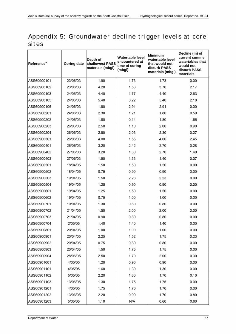
Acid sulfate soil survey of the shallow regolith on the Scott Coastal Plain Hydrogeological record series, Report no. HG24
Department of Water 57
Appendix 5: Groundwater decline trigger levels at core sites
Referencea Coring date Depth of shallowest PASS materials (mbgl)
Watertable level encountered at time of coring (mbgl)
Minimum watertable level that would not disturb PASS materials (mbgl)
Decline (m) of current summer watertables that would not disturb PASS materials
ASS60900101 23/06/03 1.90 1.73 1.73 0.00
ASS60900102 23/06/03 4.20 1.53 3.70 2.17
ASS60900103 24/06/03 4.40 1.77 4.40 2.63
ASS60900105 24/06/03 5.40 3.22 5.40 2.18
ASS60900106 24/06/03 1.80 2.91 2.91 0.00
ASS60900201 24/06/03 2.30 1.21 1.80 0.59
ASS60900202 24/06/03 1.80 0.14 1.80 1.66
ASS60900203 26/06/03 2.50 1.10 2.00 0.90
ASS60900204 26/06/03 2.80 2.03 2.30 0.27
ASS60900301 26/06/03 4.00 1.55 4.00 2.45
ASS60900401 26/06/03 3.20 2.42 2.70 0.28
ASS60900402 27/06/03 3.20 1.30 2.70 1.40
ASS60900403 27/06/03 1.90 1.33 1.40 0.07
ASS60900501 18/04/05 1.50 1.50 1.50 0.00
ASS60900502 18/04/05 0.75 0.90 0.90 0.00
ASS60900503 19/04/05 1.50 2.23 2.23 0.00
ASS60900504 19/04/05 1.25 0.90 0.90 0.00
ASS60900601 19/04/05 1.25 1.50 1.50 0.00
ASS60900602 19/04/05 0.75 1.00 1.00 0.00
ASS60900701 19/04/05 1.30 0.80 0.80 0.00
ASS60900702 21/04/05 1.50 2.00 2.00 0.00
ASS60900703 21/04/05 0.90 0.80 0.80 0.00
ASS60900704 2/05/05 1.40 1.40 1.40 0.00
ASS60900801 20/04/05 1.00 1.00 1.00 0.00
ASS60900901 20/04/05 2.25 1.52 1.75 0.23
ASS60900902 20/04/05 0.75 0.80 0.80 0.00
ASS60900903 20/04/05 1.50 1.75 1.75 0.00
ASS60900904 28/06/05 2.50 1.70 2.00 0.30
ASS60901001 4/05/05 1.20 0.90 0.90 0.00
ASS60901101 4/05/05 1.60 1.30 1.30 0.00
ASS60901102 5/05/05 2.20 1.60 1.70 0.10
ASS60901103 13/06/05 1.30 1.75 1.75 0.00
ASS60901201 4/05/05 1.75 1.70 1.70 0.00
ASS60901202 13/06/05 2.20 0.90 1.70 0.80
ASS60901203 5/05/05 1.10 N/A 0.60 0.60
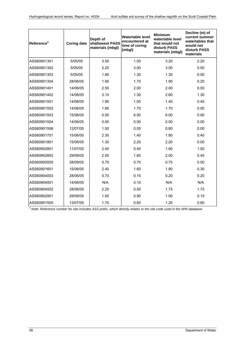
Hydrogeological record series, Report no. HG24 Acid sulfate soil survey of the shallow regolith on the Scott Coastal Plain
58 Department of Water
Referencea Coring date Depth of shallowest PASS materials (mbgl)
Watertable level encountered at time of coring (mbgl)
Minimum watertable level that would not disturb PASS materials (mbgl)
Decline (m) of current summer watertables that would not disturb PASS materials
ASS60901301 5/05/05 3.50 1.00 3.20 2.20
ASS60901302 5/05/05 2.25 3.00 3.00 0.00
ASS60901303 5/05/05 1.80 1.30 1.30 0.00
ASS60901304 28/06/05 1.90 1.70 1.90 0.20
ASS60901401 14/06/05 2.50 2.00 2.00 0.00
ASS60901402 14/06/05 3.10 1.30 2.60 1.30
ASS60901501 14/06/05 1.90 1.00 1.40 0.40
ASS60901502 14/06/05 1.80 1.70 1.70 0.00
ASS60901503 15/06/05 0.00 6.00 6.00 0.00
ASS60901504 14/06/05 0.00 0.00 0.00 0.00
ASS60901506 12/07/05 1.00 0.05 0.80 0.00
ASS60901701 15/06/05 2.30 1.40 1.80 0.40
ASS60901801 15/06/05 1.30 2.20 2.20 0.00
ASS60902801 11/07/05 2.40 0.40 1.90 1.50
ASS60902802 29/09/05 2.50 1.60 2.00 0.40
ASS60900505 28/09/05 0.70 0.70 0.70 0.00
ASS60901601 15/06/05 2.40 1.60 1.90 0.30
ASS60904003 28/06/05 0.70 0.15 0.20 0.20
ASS60904001 14/06/05 N/A 0.10 N/A N/A
ASS60904002 28/06/05 2.25 0.50 1.75 1.75
ASS60902901 29/09/05 1.50 0.90 1.00 0.10
ASS60901505 13/07/05 1.70 0.60 1.20 0.60 a Note: Reference number for site includes ASS prefix, which directly relates to the site code used in the WIN database.


www.water.wa.gov.au