accommodation of plate motion in an incipient strike-slip...
TRANSCRIPT

Confidential manuscript submitted to Tectonics
Accommodation of plate motion in an incipient strike-slip system: the Central 1
Walker Lane 2
Enter authors here: Ian K.D. Pierce 1, Steven G. Wesnousky 1, Lewis A. Owen 2, Xinnan 3
Li3, and Marc Caffee4 4
1. Center for Neotectonic Studies and Seismological Laboratory, University of Nevada, Reno, 5
NV 89557, USA 6
2. Department of Geology, University of Cincinnati, Cincinnati, OH 45221, USA 7
3. Institute of Geology, China Earthquake Administration, Beijing, China 100029 8
4. PRIME Lab, Purdue University, West Lafayette, IN 47907, USA 9
10
Corresponding author: Ian K.D. Pierce ([email protected]) 11
Key Points: 12
Slip rates of normal faulting for the Antelope, Smith, and Mason valley rangefront faults 13
are 0.6 +0.7/-0.3, 0.7 +1.0/-0.4, and <0.05 mm/yr, respectively. 14
Shear in the western Central Walker Lane is accommodated along a system of short, left-15
stepping en-echelon dextral and normal faults. 16
Some geodetic shear remains unaccounted for by geologic rates, but is likely 17
accommodated by off-fault deformation and complex rupture patterns. 18

Confidential manuscript submitted to Tectonics
Abstract 19
Geodetic studies in the Central Walker Lane report that ~7–8 mm/yr of right-lateral shear is 20
accumulating across the region. The rates and patterns of active faults bounding and within the 21
Walker Lake basin and Antelope, Smith, and Mason valleys in the western part of the Central 22
Walker Lane are the focus of this study. Lidar data and geomorphic mapping show geomorphic 23
and geometric characteristics consistent with the accommodation of oblique-slip motion along 24
the Wassuk and Smith Valley rangefront faults, while the Mason and Antelope valley rangefront 25
faults appear to be primarily dip-slip. A separate active dextral strike-slip fault in the 26
southernmost part of Mason Valley has likely produced earthquakes in the Holocene. Vertical 27
displacement rates based on cosmogenic ages of displaced alluvial fans for the range-bounding 28
faults in Antelope, Smith, and Mason valleys are 0.5 +0.5/-0.3, 0.5 +0.7/-0.4, and 0.04 +0.05/-0.03 mm/yr, 29
respectively. The vertical rates correspond to dip-parallel slip rates of 0.6 +0.7/-0.3, 0.7 +1.0/-0.4, and 30
<0.05 mm/yr, for the same three faults, respectively, assuming dips on each fault are 55 ± 10°. 31
The along-strike distribution of scarp heights indicates that the most recent and penultimate 32
earthquakes along the range bounding faults of Smith and Antelope valleys produced ~3 m 33
vertical displacements during ~Mw 7 earthquakes. The pattern of faults described here forms a 34
200-km-long left-stepping en-echelon series of dextral, oblique, and normal faults extending 35
from south of Walker Lake to north of Lake Tahoe, similar to observations of laboratory models 36
of dextral shear. 37
1 Introduction 38
39
1 Introduction 40
Geodetic observations have brought to light a problem in the Central Walker 41
Lane: while 7–8 mm/yr of northwest directed dextral shear is observed with GPS measurements 42
across this part of the Walker Lane (Thatcher et al., 1999; Hammond and Thatcher, 2005, 2007; 43
Hammond et al., 2011; Bormann et al., 2016), over half of this total shear cannot be accounted 44
for by summing the geologic slip rates of the few known strike-slip faults in this region that is 45
otherwise largely dominated by normal faulting (Wesnousky et al., 2012). We use lidar data to 46
analyze the tectonic geomorphology of Antelope, Mason, and Smith valleys, and a part of the 47
Walker Lake basin to help understand how 7-8 mm/yr of geodetically observed shear is 48
accommodated within the Central Walker Lane between Lake Tahoe and Walker Lake (Figures 49
1 and 2). Boulder and sediment samples from displaced alluvial surfaces are analyzed for 50
terrestrial cosmogenic nuclide (TCN) and optically stimulated luminescence (OSL) to better 51
constrain the slip rates of range-bounding primarily normal faults. This paper summarizes prior 52
work and our new observations bearing on style and rate of faulting for each basin. Here 53
evidence is presented consistent with a model of deformation where left-stepping right-lateral 54
strike-slip faults work in concert with normal faults and transverse left-lateral faults to form a 55
fault system that accommodates significant crustal shear across the Central Walker Lane in the 56
absence of major through-going strike-slip faults. 57
Field studies and laboratory models show that as strike-slip systems increase in total 58
displacement, the width of the shear zone decreases, while faults become longer, less complex, 59
more continuous, and more efficient at accommodating strain (Wilcox et al., 1973; Aydin and 60
Nur, 1982; Wesnousky, 1988; An and Sammis, 1996; Stirling et al., 1996; Schreurs, 2003; 61

Confidential manuscript submitted to Tectonics
Faulds et al., 2005; Atmaoui et al., 2006; Zinke et al., 2015; Hatem et al., 2017; Zuza et al., 62
2017). While many of the transform plate boundaries of the world may be considered mature and 63
capable of producing large earthquakes along well organized fault traces that have 64
accommodated hundreds of kilometers of total slip (e.g., the San Andreas, Altyn Tagh, Sagaing, 65
Denali, or Alpine faults), comparably few immature strike-slip systems have been studied in 66
similar detail (e.g., the Walker Lane, Sicily, the Shan Plateau of Myanmar, or the Shanxi Rift of 67
China). These less well-developed systems have, by this definition, accommodated lesser 68
amounts of total slip, and as a result often lack major through-going faults. Instead these systems 69
form broad regions of faulting and deformation along complex systems of numerous short, 70
discontinuous faults, which are often only capable of producing moderate earthquakes. Studying 71
these complex fault systems in nature offers unique insight into the development of fault systems 72
at a plate boundary scale that can otherwise typically only be understood in a laboratory. 73
74

Confidential manuscript submitted to Tectonics
75
76
77
78
Figure 1 Overview map of Walker Lane. Extent of Figures 2 and 9 are indicated by white boxes. Major faults are
thicker while thin faults are from USGS Quaternary fault and fold database. The Central Walker Lane can be
divided into the Carson domain (purple), western domain (yellow), and eastern domain (pink). Major faults:
MVF- Mohawk Valley, HL-Honey Lake, WS- Warm Springs, PF- Polaris, PL Pyramid Lake, OF-Olinghouse, WT-
West Tahoe, NT- North Tahoe (from west to east: Stateline, Incline Village, Little Valley, Washoe Lake), G-
Genoa, ECV-East Carson Valley, AV-Antelope Valley, SV-Smith Valley, CL-Carson Lineament, WF-Wabuska,
MV-Mason Valley, PGH- Pine Grove Hills, BP-Bridgeport Valley, WL-Walker Lake, BS-Benton Springs, PS-
Petrified Springs, MD- Mina Deflection (Rattlesnake, Excelsior, Coaldale), OV-Owens Valley, WM- White
Mountains, FLV-Fish Lake Valley.
Confidential manuscript submitted to Tectonics
1.1 Regional Context 79
The Walker Lane (Figure 1) is an approximately 500-km-long by 100-km-wide 80
northwest trending transtensional intracontinental shear zone composed of discontinuous active 81
faults, basins, and mountain ranges that accommodate up to ~20% of the ~50 mm/yr of dextral 82
shear between the Pacific and North American plates (Bennett et al., 2003; Dixon et al., 2000; 83
Thatcher et al., 1999; Unruh et al., 2003). The Walker Lane sits between the Sierra Nevada 84
Mountains to the west and the north-northeast trending normal faults and ranges of the Basin and 85
Range to the east, roughly following the California-Nevada border. The disorganization of faults 86
in the Walker Lane has been cited as evidence of the youthful expression of an incipient 87
transform boundary (e.g., Faulds et al., 2005; Faulds and Henry, 2008). The Walker Lane is well 88
defined geodetically by a zone of ~9 mm/yr of northwest directed right-lateral shear in the 89
southern part, decreasing to ~7 mm/yr in the Northern Walker Lane (e.g., Hammond et al., 2011; 90
Wesnousky et al., 2012; Bormann et al., 2016), while the San Andreas fault system 91
accommodates ~40 mm/yr of dextral shear, west of the Sierra Nevada (Unruh et al., 2003). 92
Throughout the Walker Lane, dextral shear is expressed as transtension, accommodated as strike-93
slip along well defined faults (e.g., Benton Springs; Wesnousky 2005), as series of left-lateral, 94
transverse “bookshelf faults” (e.g., Cashman and Fontaine, 2000), partitioned into normal faults 95
at range fronts with separate strike-slip faults along the interiors of basins (e.g., Owens Valley; 96
Beanland and Clark, 1994), and has been hypothesized within portions of the Central Walker 97
Lane to be taken up by rotations of crustal blocks bounded by major range-bounding normal 98
faults (e.g., Wesnousky et al., 2012). 99
The Walker Lane is divided into several regions that display distinctly different fault 100
systems (Figure 1). The Northern Walker Lane is composed of the predominantly northwest-101
striking dextral strike-slip Pyramid Lake (Briggs, 2004; Angster et al., 2016), Warm Springs 102
(Gold et al., 2013), Honey Lake (Gold et al., 2017), Polaris (Hunter et al., 2011), and Mohawk 103
Valley (Gold et al., 2014) faults. The Southern Walker Lane is composed of predominately 104
northwest striking strike-slip and normal faults, including the Owens Valley (Beanland and 105
Clark, 1994; Lee et al., 2001; Kirby et al., 2008; Haddon et al., 2016), Fish Lake Valley (Frankel 106
et al., 2007; Ganev et al., 2010; Frankel et al., 2011), and White Mountains (Stockli et al., 2003; 107
Kirby et al., 2006) faults. The Central Walker Lane interrupts this northwest structural grain with 108
a series of north-striking range-bounding faults with large normal components, transverse left-109
lateral faults, and some northwest-striking dextral faults. 110
The Central Walker Lane can be further subdivided into three domains (Figure 1). The 111
eastern domain or Walker Lake block is composed of the northwest striking dextral strike-slip 112
Benton Springs, Indian Head, Gumdrop, and Petrified Springs faults(Wesnousky, 2005; Angster 113
et al., 2019). The northerly Carson domain (e.g. Cashman and Fontaine, 2000; Wesnousky, 2005; 114
Li et al., 2017) is composed of the transverse, northeast-striking, sinistral Wabuska, Olinghouse 115
(Briggs, 2005), and Carson faults and lineaments. The western domain is composed of the basins 116
and their range-bounding faults that are the focus of this paper, including the Tahoe (Kent et al., 117
2005; Maloney et al., 2013; Pierce et al., 2017) and Walker Lake (Bormann et al., 2012; Dong et 118
al., 2014; Surpless and Kroeger, 2015) basins, and Carson (Ramelli et al., 1999; dePolo and 119
Sawyer, 2005), Smith (Wesnousky and Caffee, 2011), Mason, and Antelope (Sarmiento et al., 120
2011) valleys. 121
The western domain of the Central Walker Lane is defined by a series of subparallel 122
north-striking/east-dipping active range-bounding faults each dividing a mountain range to the 123

Confidential manuscript submitted to Tectonics
west from a half-graben holding a basin to the east. These north-strike of the ranges contrast 124
sharply with the northeast-striking ranges of the Basin and Range to the east of this region, and 125
the continuous high topography of the Sierra Nevada to the west. Most of these range-bounding 126
faults are ~30–45 km long (except for the ~85 km long Wassuk rangefront fault) and form a 127
rough left stepping en-echelon pattern, with faults spaced ~20–35 km apart from east to west. 128
The westward stratigraphic tilt of these ranges decreases to the northwest from 60° in the 129
Wassuk and Singatse ranges, to <20° in the Carson Range, and <5° in the Sierra Nevada, and 130
likewise the southeasterly Singatse and Wassuk ranges have considerably higher amounts of total 131
extension (>150%) than the ranges to the west (Surpless et al., 2002), which has been cited as 132
evidence of the progressive westward encroachment of faulting into the Sierra Nevada. 133
Thermochronologic data show that many of the mountain ranges in the region have undergone 134
two phases of exhumation: an initial period ~14–15 Ma, and a younger period sometime between 135
3 and 10 Ma (Surpless et al., 2002). This second phase was initially attributed by Surpless et al. 136
(2002) to be a result of Basin and Range extension, yet this timing coincides with the imitation of 137
the Walker Lane at these latitudes (e.g., Faulds and Henry, 2004), so may be a result of the 138
encroachment of Walker Lane deformation, while the earlier phase may be attributed to Basin 139
and Range extensional faulting (Surpless et al., 2002). 140
141
1.2 The problem of missing slip in the Central Walker Lane 142
Both cumulative lateral displacements and the geodetically measured shear rates across 143
the Walker Lane decrease from south to north. Guest et al. (2007) state that as much as ~110 km 144
of right-lateral slip has been accommodated across the Stateline, Owens Valley, Panamint 145
Valley, and Death Valley-Fish Lake Valley faults of the Southern Walker Lane since the mid-146
Miocene. In the Northern Walker Lane, Faulds et al. (2005) show that only ~20–30 km of net 147
dextral shear has been accommodated by strike-slip faults. Cashman and Fontaine (2000) and 148
Carlson (2017) present paleomagnetic evidence of >50° of clockwise vertical axis rotations that 149
have accumulated in some of the Miocene volcanic rocks of the Carson domain. Across the 150
Central Walker Lane, GPS profiles measure ~7–8 mm/yr of northwest directed dextral shear 151
(Hammond et al., 2011; Wesnousky et al., 2012; Bormann et al., 2016). This magnitude of shear 152
and rotation appears to have been largely accommodated in the absence of major through going 153
northwest-directed dextral strike-slip faults in the western domain of the Central Walker Lane, 154
and as Wesnousky et al. (2012) show, profiles can be drawn perpendicular to the trend of the 155
Walker Lane without crossing any major faults in the Central Walker Lane. 156
Optimally-oriented, closely-spaced right-lateral strike-slip faults of the Walker Lake 157
block of the Central Walker Lane accommodate ~4 mm/yr of dextral shear (Angster et al., 2019). 158
Aside from a short fault segment observed along the eastern margin of the Wassuk Range (Dong 159
et al., 2014), there are no previously reported right-lateral strike-slip faults in the western or 160
Carson domains that accommodate the remaining >3 mm/yr of dextral shear. GPS transects show 161
that the observed shear is evenly spaced across the Central Walker Lane, and is not isolated to 162
the Walker Lake block (Bormann et al., 2016). 163
Wesnousky et al. (2012) suggested that range scale block rotations and asymmetric, 164
northward-opening basins accommodate the observed geodetic shear across the western domain 165
of the Central Walker Lane. Geodetic block models (e.g. Bormann et al., 2016) suggest that as 166
much as ~1.5 mm/yr of dextral oblique slip is accommodated by each of these range-bounding 167

Confidential manuscript submitted to Tectonics
normal faults, in addition to clockwise vertical axis rotations of crustal blocks. However, the 168
paleomagnetic work of Carlson (2017) suggests that while significant block rotations have 169
occurred in the Carson domain, there has been little rotation of the ranges in the western domain. 170
Thus, strike-slip faulting in the western domain may play a larger role in accommodating Walker 171
Lane shear than has been previously recognized. Such strike-slip faulting may be either (1) 172
diffused across scattered, discontinuous faults (similar to the 1932 Ms 7.2 Cedar Mountain 173
earthquake, e.g., Bell et al., 1999), (2) accommodated by off-fault deformation that is not 174
preserved or readily observed by available paleoseismic methods (e.g., Gold et al., 2015; 175
Personius et al., 2017), or (3) accommodated along previously unrecognized major strike-slip 176
faults (e.g., Dong et al., 2014), all of which are hypotheses addressed in this paper. 177
178

Confidential manuscript submitted to Tectonics
179 Figure 2 Overview of study area. Dark grey hillshades indicate extent of lidar data. Red lines are faults 180
mapped in this study and observed cutting alluvial deposits, and dark black faults are bedrock-alluvial 181
active fault contacts. Light black lines are faults from USGS Quaternary fault and fold database. Black 182
boxes indicate the extent of Figures 3, 5, 6, and 8. Profiles A-A’ and B-B’ are plotted in Figure 10. 183
184
185
186

Confidential manuscript submitted to Tectonics
2. Resources and Methods 187
2.1 Quaternary mapping and high resolution topographic data sources 188
Descriptions of faulting characteristics along each of the faults and lineaments are 189
derived from the analysis of large-scale (~1:12,000) low-sun-angle black and white aerial 190
photographs, Google Earth satellite imagery, structure-from-motion models, and lidar data (three 191
existing datasets from the USGS, Desert Research Institute, and National Wildlife Service are 192
merged with the ~334 sq km of new data that was acquired for this project through the National 193
Center for Airborne Laser Mapping). Lidar datasets are merged into a seamless dataset for each 194
basin and then contour, and hill- and slope-shade maps are generated for geomorphic analysis. 195
Structure-from-motion elevation models are generated using Agisoft Photoscan Pro with images 196
collected using a DJI Phantom 3+ quadcopter. Images are georeferenced from sites located in a 197
target region using a Trimble R10 dGPS unit, resulting in ~25 cm/pixel resolution models. 198
Generalized surficial maps based on interpretations of lidar data and satellite imagery at a 199
scale of 1:12,000 are constructed for Mason, Smith, and Antelope valleys using a modification of 200
the methods outlined in Bull (1991) as used in various other studies in this region (e.g., Bell et 201
al., 2004; Wesnousky, 2005; Koehler and Wesnousky, 2011; Sarmiento et al., 2011; Wesnousky 202
and Caffee, 2011; Li et al., 2017). In Plate 1 and the derivative figures in this paper, deposits are 203
divided into units based on relative age and type of geomorphic landform/sediment: fluvial (Qfl), 204
basin fill (Qbf), playa/lacustrine (Qp), aeolian (Qd), and four alluvial fan units (Qa, Qy, Qi, and 205
Qo). Land obscured by anthropogenic activity (anth) and undivided bedrock (bx) are also 206
mapped. Alluvial fan units are divided by relative age primarily using height above modern 207
stream grade, amount of dissection, height of fault scarp (if present), and textural differences in 208
imagery and lidar data. Fault traces in this paper are divided as either fault scarps that are clearly 209
expressed in Quaternary deposits (red lines) or as inferred faults and/or fault contacts between 210
Quaternary deposits and bedrock (black lines). 211
Surfaces of the oldest alluvial fan units (Qo) are composed of weathered boulders with 212
soils that have well-developed Bt and carbonate horizons. These form the highest and oldest 213
alluvial fan units that are often incised >10 m with well-rounded interfluves. These Qo alluvial 214
fans are considered to be early to middle Pleistocene. Intermediate alluvial fans (Qi) are 215
moderately incised with well-developed drainage networks and are modified by shoreline 216
deposits when near the high stand of Lake Lahontan. Qi alluvial fans are considered middle to 217
late Pleistocene in age. Qy alluvial fans are low lying, and have smooth surfaces in lidar, and a 218
dark tone in imagery. Qy alluvial fans are Holocene and latest Pleistocene. Qa alluvial fans 219
represent active washes and alluvial fans, and are differentiated from Qy alluvial fans by lighter 220
tone on imagery and well-defined channel morphology. Where faults are present, Qy alluvial 221
fans are sometimes differentiated from Qa alluvial fans by fault scarps that do not cut the 222
younger Qa alluvial fans. 223
224
2.2 Geochronology 225
Surficial ages are estimated using measurements of in-situ terrestrial cosmogenic nuclide 226
(TCN) 10Be and 36Cl concentrations of surface boulders, TCN 10Be concentrations of soil depth 227
profiles, and optically stimulated luminescence (OSL) of buried sand lenses. Both 10Be and 36Cl 228
concentrations are measured at the PRIME lab at Purdue. All 10Be samples are processed in the 229

Confidential manuscript submitted to Tectonics
Geochronology Laboratories at the University of Cincinnati following the methods of Kohl and 230
Nishiizumi (1992). The OSL analyses are also performed at the University of Cincinnati. The 231 36Cl samples are processed and analyzed at the PRIME lab. Detailed descriptions of sample 232
preparation and analysis are in the Supporting Information. 233
Boulder sampling focuses on the largest boulders from alluvial fan surfaces. 234
Approximately 500 g samples are taken from the upper 2–5 cm of each of these boulders. 235
Photographs of each of the sampled boulders are provided in the Supporting Information. 10Be 236
concentrations and laboratory data are listed in Table S1. The 10Be TCN boulder exposure ages 237
are calculated using the Cosmic Ray Exposure Program (CREp) of Martin et al. (2017) and are 238
listed in Table 1. The ages reflect the increased concentrations of 10Be that occur in rock as a 239
function of the time they are exposed to cosmic rays at Earth's surface. The calculator requires 240
input describing the geographic coordinates and elevation of the samples, local shielding of the 241
sample, density of the sample, and estimation of the boulder erosion rates resulting from 242
processes such as boulder grussification and spalling (Gosse and Phillips, 2001). These values 243
are listed for each sample in Table S1. The calculations are made using no erosion rate. The age 244
estimates are also dependent on the assumption of particular scaling models designed to estimate 245
the long-term production rate of cosmogenic 10Be. The 10Be ages in Table 1 use a production 246
rate of 44.0 ± 0.3 at/g SiO2/yr determined at Twin Lakes, which is located at a higher elevation 247
than the fan surfaces here, but is within 100 km of all study sites (Balco et al., 2008; Borchers et 248
al., 2016; Nishiizumi et al., 1989), the ERA40 atmosphere model of Uppala et al. (2005), the 249
Lifton-VDM2016 geomagnetic database (Lifton, 2016), and the time-dependent scaling model of 250
Lal (1991) and Stone (2000). The 36Cl boulder ages are calculated using the CRONUS calculator 251
for 36Cl, and are listed in Table 1, with laboratory details in Table S2. 252
To determine the age of a surface using a cosmogenic depth profile, a ~2-m-deep profile 253
is excavated and the exposed sediment is sampled at varying depths for 10Be analysis. The 254
resulting 10Be concentrations as a function of depth are modeled using the Hidy et al. (2010) 255
MATLAB code, which uses a Monte-Carlo simulation to find the best fit of the data and 256
resulting surface age. Soil textural grain size analysis is performed by A&L Great Lakes 257
Laboratories, Inc. 258
OSL samples are extracted using 20-cm-long plastic tubes from sand lenses exposed in a 259
hand excavated pit. All tubes are packed and wrapped double-bagged in opaque media for 260
transport. OSL samples are processed and analyzed at the luminescence dating laboratories at the 261
University of Cincinnati in subdued sodium lighting (588 nm). Quartz grains are isolated from 262
heavy minerals and feldspars using pretreatment with H2O2, HCl and HF, and magnetic 263
separation. Modified single-aliquot regeneration (SAR) protocols (Wintle and Murray, 2006) 264
were employed on small aliquots (200–500 grains; 100–150 μm in diameter) to estimate 265
equivalent doses using a Risø OSL DASH measurement system. U, Th, Rb, and K are measured 266
at Activation Laboratories Limited Ancaster, Ontario Canada to determine sediment dose rates 267
and estimations of the contribution of cosmic dose rate accounted for geographic position, 268
elevation, and depth, burial depth, and water content as outlined in Table S3. 269
270
2.3 Scarp height measurements 271
Fault scarp vertical heights are determined by extracting topographic profiles from lidar 272
data. Topographic profiles are extracted approximately orthogonal to fault scarps where both 273

Confidential manuscript submitted to Tectonics
hanging and footwall surfaces are similar and show minimal to no modification by geomorphic 274
and anthropogenic processes unrelated to faulting (e.g., road cuts, younger fan deposition, fluvial 275
modification, etc.). Profiles are analyzed using a python code written for this study (see 276
Supporting Information) that fits linear regressions to points selected by the user that are 277
representative of the hanging wall, foot wall, and fault scarp surfaces. The vertical separation 278
between the footwall and hanging wall regressions is then measured at the horizontal midpoint of 279
the intersections between the fault scarp and each of the hanging and foot walls (e.g. Rood et al., 280
2011). 281
282
2.4 Slip Rate Calculations 283
Vertical slip rates are determined by dividing the probability distributions of the 284
displacement of a surface by the age of the displaced surface using the MATLAB code of Zechar 285
and Frankel (2009). The probability distribution of the age of a surface is the sum of the 286
uncertainties of all of the samples from a single surface. This approach is taken to reduce the 287
uncertainty of scattered sample ages resulting from inheritance or erosion. With this method all 288
samples are treated equally. The uncertainty of the displacement is assumed to be Gaussian, 289
described by the mean and standard deviation of the scarp heights of a number of profiles 290
extracted perpendicular to a fault scarp in a deposit of a single age. A Gaussian distribution is 291
used to better estimate the actual average fault offset from a number of measurements of fault 292
scarps, modified unknown amounts by erosion on the hanging wall, deposition on the footwall, 293
and the natural variability of the earthquake displacement along fault strike. The approach is thus 294
aimed at determining an “average” slip rate, rather than a maximum or minimum bound, along a 295
particular fault section where numerous measurements of age and displacement are recorded. 296
297
3. Study Areas 298
3.1 Antelope Valley 299
Antelope Valley is a west tilted half-graben with a northwest striking, east-dipping active 300
rangefront fault along its western margin separating the basin from the mountains to the west 301
(Figure 2). The West Fork of the Walker River flows from south to northeast through the basin, 302
generally following the western side, and likely obscuring any long-term evidence of faulting 303
along its path within the valley. The rangefront exhibits frequent, prominent triangular facets, 304
and forms ~800 m of relief above the valley floor. While the overall trend of the fault follows a 305
~23-km-long northwest trace, fault scarps are only expressed in intermediate and young alluvial 306
deposits for ~15 km of that length, and generally form a left-stepping pattern of discontinuous 307
mostly north-trending fault scarps (Figure 3). Fault scarps in late Quaternary alluvial deposits 308
that range in height from ~1–3 m to >20 m commonly occur at the mouths of drainages (Figure 309
3), demonstrating the repetition of late Quaternary earthquakes. Topaz Lake obscures any 310
evidence of the rangefront fault along the northwestern portion of Antelope Valley. North of 311
Topaz Lake, and outside of our lidar data, there are discontinuous scarps approaching Double-312
Springs Flat (Figure 2). 313
314
3.1.1 Walker Slip Rate Site 315

Confidential manuscript submitted to Tectonics
A large uplifted alluvial fan terrace is present just northwest of the town of Walker 316
(Figure 3). Five profiles measured across different parts of the fault scarp at this site (Figure 3c) 317
have vertical separations ranging from 21.3 to 32.5 m, with a mean value of 27.5 ± 4.3 m. The 318
surface here forms an ~1-m-thick alluvial cap exhibiting numerous boulders on a bedrock 319
pediment surface that is incised over 20 m by drainages (Figure 3c). The faulted surface 320
exhibits a bench of slightly lower elevation adjacent to the fault. The surface of this bench 321
contains a thin scattered rounded cobble deposit that was likely deposited by the Walker River. 322
Not only does the scarp itself appear to be modified by the Walker River, but the lower surface 323
here is buried by younger fan activity and fluvial deposition from the nearby Walker River, and 324
thus this measured displacement is a minimum. Boulders on the Qi surface here are heavily 325
weathered, mostly volcanic rocks sourced from the nearby Sierra Nevada. Here, we collected six 326
boulder samples for 36Cl cosmogenic analysis (Table 1). Resulting ages range from 33.3 to 327
111.0 ka (Figure 3c). Combining the average vertical separation with this age distribution results 328
in a vertical separation rate of 0.5 +0.5/-0.3 mm/yr (Figure 4). The section of rangefront 329
immediately adjacent and north of this site is composed of a several hundred meter tall granite 330
bedrock escarpment with slopes ranging from 50 to >70° (Figure 3a), which may reflect a steep 331
dip of the range front fault. 332
333
3.1.2 Faulting in east Antelope Valley 334
The east side of the basin contains a series of uplifted, faulted, and tilted alluvial surfaces 335
that appear to grade into pediment surfaces extending westward from the crest of the Wellington 336
Hills (Figure 2). The surfaces are mostly outside of the extent of the available lidar data. Google 337
Earth imagery shows a series of discontinuous both north and northwest trending fault scarps. 338
Many of the fault scarps are uphill (east) facing with some exhibiting right-lateral deflections of 339
drainages, which may be a result of strike-slip faulting. The alluvial surfaces in the eastern part 340
of the valley are incised by numerous small drainages and appear to be intermediate and old 341
(Plate 1). The scarps within the surfaces are generally small and likely do not rupture frequently. 342
At one location in eastern Antelope Valley a channel incised into a broad Qi alluvial fan 343
is obliquely cut by a short ~300-m-long fault trace of relatively weak geomorphic expression 344
(Figure 3b). The fault forms a slight (~0.5 m) uphill-facing fault scarp in the Qi fan and appears 345
to laterally displace this channel ~70 m. Three samples were extracted from sand lenses exposed 346
in a pit dug into the Qi surface and were dated using OSL. Samples EA1 and EA2 were 347
saturated, with a likely age of >51 ka, and EA3 resulted in an age of 56.6 ± 5.2 ka. Combining 348
this minimum age of 56.6 ± 5.2 ka with this displacement of ~70 m results in a maximum right-349
lateral slip rate of 1.2 ± 0.4 mm/yr. The estimated slip rate seems anomalously high in relation to 350
the short length of the fault strand, the relatively weak geomorphic expression of the scarp, and 351
the lack of offsets in the younger deposits farther along strike closer to the Walker River. 352
Nonetheless, we present the observation to illustrate the only possible direct evidence we 353
observed for strike-slip motion along the east side of the valley. If this >57 ka age is assumed for 354
the rest of the Qi alluvial fan surfaces in eastern Antelope Valley, then the lack of geomorphic 355
expression of significant faulting suggests that the few discontinuous fault scarps here are not 356
accommodating a significant amount of the regional strain. 357
358
359

Confidential manuscript submitted to Tectonics
360 Figure 3 Section of Antelope Valley rangefront showing left-stepping pattern (aA) and location of Walker 361
slip rate site (c). (b) is a section of eastern Antelope Valley (location in Fig. 2) where a Qi alluvial fan is 362
apparently offset ~70 m. Location of OSL samples EA1-3 with minimum age of 56.6 ± 5.2 ka are 363
indicated. Black faults are bedrock-alluvial fault contacts. Red faults are fault scarps in alluvial deposits. 364
Straight black lines are scarp profiles and values are scarp heights in (m). Walker slip rate site 365
interpreted (c) and bare lidar hillshade (d). Scarp profiles (black lines), heights (in m), and ages (ka) of 366
boulder samples (white dots) are shown in (c). 367
368

Confidential manuscript submitted to Tectonics
369 Figure 4 Displacement, age, and vertical slip rate probability distributions for the Antelope Valley and 370
Smith Valley range bounding faults. For each plot, probability densities are the solid lines (left axis), 371
while cumulative probabilities are the dashed lines (right axis). 372
373

Confidential manuscript submitted to Tectonics
374
TABLE 1. GEOCHRONOLOGY
Method Sample name Location Elevation Age 1σ error
latitude longitude above sea
level
(oN) (oW) (m) (ka) (ka)
Mason Valley Upper Yerington Fan 10Be Boulder MVS1 38.9669 119.2012 1424 451.1 37.2
10Be Boulder MVS2 38.9661 119.2019 1430 93.3 6.6
10Be Boulder MVS3 38.9660 119.2034 857 183.5 13.5
10Be Boulder MVS4 38.9653 119.2028 1431 90.5 6.9
10Be Depth Profile M1-Pit 38.9669 119.2012 1425 173.1 38.7/-32.5
Smith Valley Artesia Fan - intermediate surface 10Be Boulder SF1 38.8908 119.4158 1494 30.2 2.6
10Be Boulder SF2 38.8909 119.4163 1497 19.3 1.6
10Be Boulder SF3 38.8903 119.4158 1491 40.4 2.8
Artesia Fan - intermediate surface (Wesnousky and Caffee, 2011)
10Be Boulder CWL-2 38.8907 119.4150 1480 32.5 3.0
10Be Boulder CWL-3 38.8907 119.4148 1470 40.7 3.7
10Be Boulder CWL-4 38.8907 119.4148 1480 69.9 6.3
Artesia Fan – upper younger surface 10Be Boulder SF4 38.8892 119.4164 1494 21.3 2.0
10Be Boulder SF5 38.8892 119.4165 1494 12.1 1.7
10Be Boulder SF6 38.8893 119.4171 1500 34.7 2.9
Artesia Fan - lower younger surface 10Be Boulder SF8 38.8892 119.4149 1468 27.4 2.6
10Be Boulder SF9 38.8892 119.4148 1472 26.6 3.0
10Be Boulder SF10 38.8894 119.4145 1458 13.4 2.1
10Be Boulder SF11 38.8888 119.4142 1450 10.3 1.3
Antelope Valley Walker Fan 36Cl Boulder CWL-5 38.54039 119.5023 1654 58.0 6.1
36Cl Boulder CWL-6 38.54071 119.5025 1650 111.0 13.0
36Cl Boulder CWL-7 38.54069 119.5024 1649 59.0 8.1
36Cl Boulder CWL-8 38.54164 119.5049 1657 63.2 6.6
36Cl Boulder CWL-9 38.54169 119.5048 1659 50.3 5.8
36Cl Boulder CWL-10 38.54208 119.5043 1654 33.3 3.9
East Antelope Fan
OSL EA1-160 38.695538 119.45527 1580 >51 -
OSL EA2-140 38.695538 119.45527 1580 >51 -
OSL EA3-120 38.695538 119.45527 1580 56.6 5.2
Table 1. Geochronology. Details are in Supporting Information

Confidential manuscript submitted to Tectonics
3.2 Smith Valley 375
Smith Valley is a half-graben with a NNW-striking active rangefront fault bounding the 376
Pine Nut Range to the west (Figure 2). The half graben is ~50-km-long, and 15-km-across at its 377
widest. The total vertical relief from the valley floor to the crest of the Pine Nut Range is over 378
1400 m. The West Fork of the Walker River enters Smith Valley through a narrow canyon near 379
the town of Wellington (Figure 2). It bends northeastward here and meanders across the basin 380
through a canyon of increasing depth before it exits the valley on the eastern side, cutting 381
through the Singatse Range. This canyon is cut into lacustrine and fluvial deposits, likely 382
deposited by Pluvial Lake Wellington, which reached a highstand of 1477 m above sea level 383
(asl) between 60 and 80 ka (Stauffer, 2003; Wesnousky and Caffee, 2011). In the central part of 384
the basin, just north of the Walker River, there are a pair of left-stepping, north striking, en-385
echelon fault strands that form 1–2-m-high scarps in stabilized aeolian/dune deposits (Figure 2). 386
The faults do not cut any of the younger floodplain deposits closer to Walker River. Artesia 387
Lake, a small playa remnant of pluvial Lake Wellington (Stauffer, 2003), is present in the 388
northern part of Smith Valley, and is hydrologically isolated from the Walker River. 389
The range bounding fault in Smith Valley forms an abrupt rangefront with triangular 390
facets, scarps in young alluvial fans, and uplifted alluvial terraces. The rangefront fault generally 391
strikes northwest and makes several northeast-striking right steps separating otherwise long, 392
northwest striking linear sections (Figure 2). When the strike of the fault changes from north-393
northwest to northeast within these right-steps, both the frequency of scarps and their heights 394
increase dramatically from less frequent ~6–8-m-high scarps in the linear NNW sections to >20-395
m-scarps along the largest of these northeast striking step overs near the Artesia Fan (Figure 5). 396
The fault primarily exhibits down to the east/southeast vertical displacement, and nowhere did 397
we observe laterally displaced stream channels recording right-lateral strike-slip motion. The 398
faulting in the southernmost portion of the basin near the Wellington Hills forms a horsetail 399
splay (Figure 2) of numerous large (~5–10-m-high) scarps. These scarps are generally sub-400
parallel to the northward drainage of the basin in this area and thus may be modified by fluvial 401
processes. The northern portion of Smith Valley is occupied by the Buckskin Range, which is 402
bounded by an active fault on its east flanks. This fault forms a fairly continuous north-northeast 403
striking scarp in young, intermediate, and older alluvial fan deposits. To the west of the Buckskin 404
Range, there is a continuation of the Smith Valley rangefront fault, and here we observe frequent 405
grabens, en-echelon fault scarps, and vertically displaced Holocene Qy alluvial deposits. 406
407
3.2.1 Artesia Fan slip rate site 408
At the eastern edge of a ~1.4-km-long right-step over in the north-northwest striking 409
rangefront fault (Figure 5), older fan surfaces exhibit progressively larger vertical scarps than 410
younger surfaces. Three alluvial fan surfaces are mapped in Figure 5b: Qa are the active alluvial 411
fan deposits, forming a narrow active channel cut into young Qy deposits, and on the basin floor 412
form a small fan overtopping Qy deposits. These Qy deposits form an alluvial fan on the hanging 413
wall of the fault as well as on the margins of the main Qa channel on the footwall, and are 414
composed of light gray, rounded, unweathered granitic boulders in a poorly-sorted matrix. 415
Intermediate Qi deposits are only found on the footwall of the fault and are redder in color, with 416
a smoother, less bouldery surface than Qy. The fault has an anastomosing pattern in Figure 5b 417
that, from south to north, starts as a single strand, splits into two, then three strands, before 418

Confidential manuscript submitted to Tectonics
coalescing into a single strand again. A maximum age of the Qi fan here is constrained by a 60–419
80 ka tephra exposed in a road cut in the fault scarp (Stauffer, 2003; Wesnousky and Caffee, 420
2011). We collected 10 boulder samples for 10Be analysis on the Qi and Qy displaced alluvial fan 421
units and combined these with 3 recalculated 10Be boulder ages at this site from Wesnousky and 422
Caffee (2011) (Figure 5b). Six boulder samples were collected from the footwall of the 423
intermediate unit (Qi, Figure 5b), and range in age from 18 to 66 ka (mean age of 37.0 ± 16.3 424
ka), and seven samples from both the hanging and footwalls of a younger aged alluvial fan unit 425
(Qy, Figure 5b) range in age from 10 to 33 ka (mean age of 19.7 ± 8.9 ka) (Table 1). While 426
these ages are scattered, the mean ages of the young surface are roughly half of that from the 427
intermediate surface. The average of four profiles measured from the available lidar data (Figure 428
5) show that scarp height in the single strand that cuts the intermediate unit is 19.5 ± 4.5 m, while 429
two profiles of each of the two scarps in the younger unit measure 3.8 ± 0.1 and 6.6 ± 0.2 m, 430
respectively, or 10.5 ± 0.1 m combined (Figure 5). Dividing these scarp heights by the ages of 431
the boulder samples from each surface leads to a vertical separation rate of 0.6 +0.8/-0.2 mm/yr for 432
the intermediate surface and 0.5 +0.7/-0.2 mm/yr for the young surface (Figure 4). The two rates 433
over different timescales generally agree. 434
Both the linearity and strike of the long northwest striking segments of the rangefront in 435
Smith Valley suggest that a component of strike-slip is accommodated along the rangefront fault. 436
The Artesia fan is located on the edge of the largest right-step in the Smith Valley rangefront, 437
where scarps are both more frequent and larger than elsewhere along the rangefront (Figure 5), 438
and the strike in this step is nearly perpendicular to the primary northwest strike of the 439
rangefront. In a right-lateral fault system, right-steps produce extension parallel to the trace of 440
the right-lateral fault (Figure 5d). The vertical displacement at the Artesia Fan is attributed to the 441
kinematics of a right-step in a northwest striking fault with a large component of right-lateral 442
strike-slip. For an obliquely slipping rangefront like Smith Valley, a low rate of lateral-slip may 443
lead to the burial/obfuscation of possible geomorphic indicators of discrete lateral earthquake 444
offsets. 445
446

Confidential manuscript submitted to Tectonics
447 Figure 5 Section of Smith Valley rangefront showing geometry of large right step (a) and location of 448
Artesia fan slip rate site (b, c). Black faults are bedrock-alluvial fault contacts, while red faults are fault 449
scarps in alluvial deposits. Values in (a) are scarp heights (in m). Artesia fan rate site interpreted (b) and 450
bare lidar hillshade (c). Scarp profiles, heights (in m), and ages (ka) of boulder samples (white dots) are 451
shown in (b). (d) Simplified block diagram of a right-bend in a right-lateral oblique fault system provided 452
to explain relatively larger vertical displacements in the step. 453
454

Confidential manuscript submitted to Tectonics
3.3 Mason Valley 455
Mason Valley is a 55-km-long by 20-km-wide half-graben bounded by active faults 456
separating the basin from the Singatse Range to the west and the Pine Grove Hills to the 457
southwest (Figure 2). The Desert Mountains bound the northern margin of Mason Valley where 458
the northeast-striking left-lateral Wabuska fault is located (Li et al., 2017). The Singatse Range is 459
considerably smaller in topographic expression than the other ranges in this region, forming only 460
~700 m of relief above the valley floor. The northern portion of the basin was occupied by 461
pluvial Lake Lahontan during its high stand ~14.5 ka (Adams and Wesnousky, 1998; Reheis, 462
1999), and prominent wave-cut shoreline benches and beach deposits are preserved on Qy 463
deposits that are below the ~1332 m elevation of the high stand. Evidence for any pre-Holocene 464
faulting in much of the northern portion of the basin may be obscured by lacustrine processes 465
associated with Lake Lahontan and evidence of more recent faulting in the central portion of the 466
basin may be obscured by agricultural activity. 467
The region to the east/southeast of Mason Valley, and east of the Churchill Mountains in 468
Figure 2, forms a series of complicated small basins and mountain ranges composed of incised 469
Qi aged and older fan/pediment surfaces, short discontinuous faults, and disrupted bedrock 470
(Plate 1) (Gilbert and Reynolds, 1973). These basins are both oriented north-south and east-west. 471
The faults in this part of the basin strike both north-northwest and east-northeast, and are 472
generally only traceable for a maximum of ~5 km. 473
The fault at the base of the Singatse Range forms a sinuous trace with frequent left and 474
right steps and bends from ~5 km south of where the west fork of the Walker River enters the 475
basin for ~35 km northward (Figure 2). The Singatse range front is composed of prominent 476
triangular facets, suggestive of active normal faulting, however the fault along the Singatse 477
Range is almost always only expressed as a bedrock alluvium contact, except for the site 478
described in the following section, and forms a sharp contrast with other major range bounding 479
faults in the area that often exhibit scarps in young alluvial deposits. In several places along the 480
rangefront small antithetic grabens are observed, yet there is a dearth of uplifted fan surfaces. 481
The character of rangefront faulting in Mason Valley abruptly changes ~5 km south of 482
where the west fork of the Walker River enters the southwestern margin of the basin (Figure 2) 483
The southern part of the basin is bound by the Pine Grove Hills, and instead of forming a 484
rangefront composed of sharp triangular facets, the rangefront is subdued and is composed of a 485
series of uplifted old alluvial fans and pediments. Here, satellite imagery and lidar data show a 486
discontinuous series of linear, northwest-striking faults and lineaments that extend for ~22 km 487
until the southernmost extent of the basin. Generally these faults have a northeast down sense of 488
motion, and locally right-laterally displace fan deposits and channels. 489
490
3.3.1 Yerington Fan slip rate site 491
Adjacent to the Yerington Pit (Figure 6) a northwest striking fault scarp merges with a 492
northeast striking fault scarp to form a large northeast striking graben cutting intermediate age 493
alluvial fan deposits (Figure 6). The alluvial fan is incised up to ~6 m by channels and forms 494
broad smooth interfluve surfaces with infrequent highly weathered granitic and volcanic 495
boulders. Depending on where fault profiles are measured (Figure 6), vertical separation varies 496
from as little as 1.4 m across the graben at the northeastern extent of the fault scarp to as much as 497

Confidential manuscript submitted to Tectonics
10.8 m, with an average of 6.5 ± 3.6 m for the 6 profiles. Here, we collected a depth profile of 4 498
samples as well as 4 surficial boulder samples for cosmogenic 10Be analysis to constrain the age 499
of the faulted surface. Boulder ages sampled from the Qo surface here range from 90.5 ± 6.9 ka 500
to 451.1 ± 37.2 ka with a mean of 204.6 ± 169.9 ka, and modeling the depth profile results in an 501
age of 173.1 +38.7/-32.5 ka (Figure 7). The well-developed soil, with a thick Bt horizon, (Figure 502
7b) is consistent with the modeled age of the depth profile. Combining the 173.1 +38.7/-32.5 ka age 503
of the depth profile with the 6.5 ± 3.6 m average displacement of the surface results in a vertical 504
slip rate of <0.04 mm/yr. The geometry of the linear northwest striking fault segment associated 505
with a large northeast striking graben is consistent with northwest-directed dextral motion, 506
however the measured slip rate is very low and thus this fault does not likely accommodate a 507
significant amount of the regional strain. 508
509
3.3.2 Pine Grove Hills fault zone 510
Figure 8a is a Google Earth satellite image of a portion of the southern part of 511
Mason Valley (Figure 2). Here, several subparallel fault traces are well expressed as a series of 512
linear bedrock ridges and scarps in different ages of alluvial fans (Plate 1). The linear bedrock 513
ridges are primarily composed of Mio-Pliocene sedimentary and volcanic rocks, including the 514
Morgan Valley and Coal Valley formations (Gilbert and Reynolds, 1973). Figure 8b is a 515
Quaternary map based on a hillshade of a 0.25 m/pixel resolution structure-from-motion model 516
of a part of one of these northwest striking fault-lineaments, where a linear fault trace right-517
laterally displaces Qy and Qi deposits. Two Qi terrace risers are displaced ~25 and ~18 m right-518
laterally, and a channel is dextrally offset ~20 m by this fault. Additionally along the strike of 519
this fault are two beheaded channels, two right-laterally deflected channels, and a small shutter 520
ridge (Figure 8b). Additionally, the direction of the scarp produced by the fault changes from 521
west facing, to east facing, to west facing again along strike, demonstrating the strike-slip nature 522
of this fault. The morphology of the Pine Grove Hills fault is similar to other active strike-slip 523
faults in the region with slip rates ranging from ~0.5 to 1.5 mm/yr (e.g., Wesnousky, 2005; 524
Angster et al., 2019). No age estimates of the offset surfaces are available to determine a slip 525
rate for the Pine Grove Hills fault. 526
527
528

Confidential manuscript submitted to Tectonics
529 Figure 6 Section of Mason Valley rangefront (a) showing lack of fault scarps preserved in alluvium (red) 530
and location of Yerington fan slip rate site (b). Yerington fan rate site interpreted (b) and bare lidar 531
hillshade / low sun angle aerial photo composite (c). Scarp profiles, heights (in m), and ages (ka) of 532
boulder samples (white dots) are shown in (b), while the age and location of the depth profile (Figure 7) 533
is indicated by the star. 534
535
536

Confidential manuscript submitted to Tectonics
537 Figure 7 Results for the Mason Valley depth profile sampled at the Yerington fan, modeled using the Hidy 538
et al. (2010) MATLAB code. The resulting age is 173.1 +38.7/-32.5 ka. (a) distribution of modeled results for 539
the age of the depth profile. (b) Monte Carlo solutions (left) of concentration of 10Be vs. depth and soil 540
textural analysis with well-developed Bt horizon (right) overlain on a photograph of the upper portion of 541
the depth profile. 542
543

Confidential manuscript submitted to Tectonics
544 Figure 8 Satellite image of the Pine Grove Hills fault zone in southern Mason Valley (a). Location indicated 545
in Figure 2. Red lines indicate faults in alluvial deposits, while black are fault traces in bedrock. (b) 546
shows an interpreted SfM model (c) of a section of this fault zone that demonstrates right-lateral 547
displacements. 548
549
3.4 Walker Lake Basin 550
The Walker Lake basin (Figure 9) is the largest basin of those examined and is ~100-km-551
long by 20-km-wide. The western margin of the basin is bound by the Wassuk range, which 552
hosts a prominent active east-dipping normal fault, forming more than 2200 m of vertical relief. 553
The vertical slip rate (>0.3–0.4 mm/yr) and paleoseismic history of this fault zone are described 554
by Bormann et al. (2012). Dong et al. (2014) describe an active strike-slip fault in the northern 555
part of the basin that displaces Lahontan aged shoreline deposits at a right-lateral slip rate of ~1 556
mm/yr (Figure 9b). Here observations are focused on additional evidence of strike-slip faulting 557
and fault geometry (Figure 9). 558
The geometry of the Wassuk rangefront in Figure 9a provides a basis to divide the fault 559
into 3 segments. From north to south, a linear northwest striking segment extending northwest 560
from near Schurz, a central sinuous roughly north and northeast striking segment along the 561
western shore of Walker Lake, and a southern northwest striking linear segment from Hawthorne 562
to Whiskey Flat (Figure 9d). This central section forms a right-step in the fault system. The 563
deepest portion of the basin, Walker Lake, is located in the right-step. This geometry of the 564

Confidential manuscript submitted to Tectonics
Walker Lake fault system has been previously described as a rhomboidal pull-apart in a strike-565
slip system (Mann, 2007), with Walker Lake itself situated in the depocenter of this pull-apart 566
(Link et al., 1985). This geometry is similar to the step-over observed in Smith Valley, but on a 567
larger scale (Figures 2 and 4). 568
Directly west of Hawthorne (Figure 9c) is a northwest-trending, linear, uphill-facing 569
fault scarp that right laterally displaces two terrace risers as well as a series of gullies. From this 570
area south to Lucky Boy Pass (Figure 9d), the fault forms a right-stepping pattern of north and 571
northeast trending normal fault scarps and northwest trending linear scarps. 572
North of Lucky Boy pass are a series of north-striking grabens and prominent vertical 573
fault scarps (Figure 9d). From Lucky Boy pass to the southeast is a linear northwest striking 574
linear fault segment that extends for ~10 km. The first ~3 km of this fault segment forms a north 575
facing fault scarp along the rangefront. The strike-slip fault trace then continues to the southeast 576
linearly away from the rangefront forming subdued uphill-facing fault scarps. The remainder of 577
this fault segment forms two fault traces that form south and north facing scarps and a prominent 578
pop-up, pressure ridge-like feature of uplifted bedrock, fan, and pediment surfaces. South from 579
here the fault bends to the southeast more and forms subdued scarps in a large distal fan, before 580
again forming a second popup feature, similar in scale to the first. The rangefront southward 581
from here is more northerly striking and forms a number of east facing scarps at canyon mouth 582
drainages. The faulting mapped along a portion of the rangefront in Figure 9d is an example of 583
strain partitioning: where a basin-ward strike-slip fault is separated from a rangefront normal 584
fault. 585
The ~30-km-long series of fault segments extending from the southern margin of Walker 586
Lake to Whiskey Flat (Figure 9d) is generally northwest striking. Normal displacements 587
observed in north-striking bends are systematically larger than observed along the northwest-588
striking linear segments. The linearity of the fault traces, the alternating-facing fault scarps, and 589
the several beheaded channels and lateral displacements in the northwest-striking portions of the 590
fault zone, and the magnitude of scarps in the north-striking right-steps are all consistent with 591
northwest directed dextral faulting. 592

Confidential manuscript submitted to Tectonics
593 Figure 9 Fault map (a) of the Wassuk fault zone. Lidar hillshades are darker gray, light gray background is 594
a hillshaded 10 m DEM. Red lines are fault scarps in alluvial deposits, black are inferred and/or 595
bedrock-alluvial fault contacts. The fault geometry forms two northwest striking segments separated by a 596
large right step coincident with Walker Lake and the deepest part of the basin. The northwest striking 597
segments contain alternating scarp directions, linear scarps, and right-lateral displacements, all 598
consistent with strike-slip faulting. Right-stepping segments locally exhibit greater degrees of normal 599
faulting. Locations of (b-d) are indicated on (a). (b) Blowup of site from Dong et al. (2014) showing 14 m 600
right-lateral displacement of ~14.5 ka Lahontan shorelines with slip rate of ~1 mm/yr. (c) Segment of 601
fault near Hawthorne where an uphill facing linear scarp deflects a number of channels and offsets a pair 602
of terrace risers ~6 m. (d) shows the southern portion of the Wassuk fault zone. Here strain is partitioned 603
into a linear basin-ward strike-slip fault and a normal fault against the range. 604
605

Confidential manuscript submitted to Tectonics
4 Discussion 606
4.1 Displacement distributions, recurrence intervals, expected magnitudes of earthquakes, and 607
“short” faults in the Central Walker Lane 608
Scarp heights are measured along the lengths of the Smith and Antelope valley rangefront 609
faults to produce displacement distribution plots (Figures 2 and 10). These scarp heights are 610
snapped to a linear approximation of each rangefront fault. The distance along this line of each 611
of these measurements is plotted against the height of each measurement to demonstrate the 612
distribution of scarp heights along the strike of the fault. Additionally, histograms with 1.0 m 613
vertical displacement bins are presented to analyze the displacement distribution for clusters that 614
might be attributable to individual paleoseismic events (Figure 10). Combining these 615
displacement distribution plots (Figure 10) with the length of the faults and the slip rates 616
(Figure 4) for the range-bounding faults in Smith and Antelope valleys allows for an estimation 617
of the magnitude of paleoearthquakes as well as anticipated average return times for earthquakes. 618
The most recent two peaks of the histograms of vertical displacements for Antelope and 619
Smith valleys (Figure 10) are interpreted as the vertical displacement resulting from the most 620
recent event (MRE) and penultimate earthquakes. These displacements are 3.9 and 2.1 m for 621
Smith Valley and 3.2 and 3 m for Antelope Valley. Displacements observed in prior 622
paleoseismic trench studies on the two faults are similar: 3.5 m for the MRE in Smith Valley 623
(Wesnousky and Caffee, 2011) and 3.6 and 2 m (Sarmiento et al., 2011) for the MRE and 624
penultimate earthquakes in Antelope Valley. 625
For Smith Valley, dividing the 3.9 and 2.1 m MRE and penultimate events by the ~0.6 626
mm/yr vertical separation rate determined for the fault in this study results in estimated 627
earthquake return times ranging from 3500 to 6500 years. The result is in general accord with the 628
report of the single earthquake ~3000 years ago reported by the paleoseismic trench study of 629
Wesnousky and Caffee (2011) for the fault. For Antelope Valley, dividing the 3.2 and 3 m 630
displacements by the 0.5 mm/yr vertical separation rate results in earthquake return times 631
ranging from 6000 to 6400 years. Sarmiento et al.’s (2011) trenching study in Antelope Valley 632
showed an inter-event time between the most recent and penultimate earthquakes equal to ~5000 633
years, which is also similar to the ~6000 year estimate based on the slip rate and displacement 634
distribution. 635
The definition of moment magnitude is (modified after Hanks and Kanamori, 1979): 636
𝑀𝑤 =2
3log(𝜇𝐴𝑑) − 10.7 637
where, here we assume that the fault area (A) is equivalent to the fault width (15 km 638
estimated here) multiplied by the measured map view length of each fault (50- and 22-km for 639
Smith and Antelope valleys, respectively), the average displacement (d) is measured for the 640
MRE from the displacement distributions, and the shear modulus (μ) is 3 x 10¹¹ dynes/cm2. 641
These inputs result in an expected Mw 7.3 for Smith Valley and Mw 7.0 for Antelope Valley for 642
the most recent events on each fault, respectively. Surficial displacements are less than fault 643
displacement at depth, and fault rupture lengths are poorly constrained by mapped fault scarps, 644
so these are likely underestimates of magnitude. 645
Using the relation of fault length to moment magnitude from Wesnousky (2008) results 646
in expected magnitudes of 6.9 and 6.7 for the 50- and 22-km-long faults in Smith and Antelope 647

Confidential manuscript submitted to Tectonics
valleys, respectively. These estimates are approximately a quarter magnitude less than estimated 648
using the moment magnitude equation above. Likewise, for the mapped fault lengths, the 649
expected displacements for these faults should be on average 1.5 and 0.7 m, with maxima of 4.5 650
and 2.0 m, respectively (Wesnousky, 2008). These average values are roughly half and a quarter 651
of what is observed along the Smith and Antelope valley rangefront faults, respectively. Average 652
displacements of ~3 m, similar to values observed on each of these faults, are typically 653
associated with a normal fault surface rupture length of ~100 km (Wesnousky, 2008). Two 654
hypotheses can explain the observation that observed fault lengths appear insufficient to produce 655
the observed offsets: (1) faults in this part of the Walker Lane rupture with other nearby faults 656
producing longer total rupture lengths, or (2) these faults rupture independently and produce 657
high-stress drop earthquakes. 658
The size of the observed single event displacements on a number of other faults in this 659
region (e.g., the Incline Village, Little Valley, Stateline, Pine Grove Hills, Bridgeport Valley, 660
and the unnamed faults of eastern Mason Valley) are also greater than expected from historical 661
observations relating fault rupture length to displacement (Wesnousky, 2008; Seitz and Kent, 662
2014). The traces of several of these faults are less than 20 km yet some have been demonstrated 663
to have produced single event displacements of ~3 m. Faults in the Central Walker Lane may 664
produce complicated, multi-segment ruptures with multiple shorter fault strands (including 665
previously unrecognized fault strands) supporting larger (Mw 7+) earthquakes, not dissimilar to 666
the 1891 Mw 7.5 Nobi, Japan (Kaneda and Okada, 2008), 1932 Ms7.2 Cedar Mountain, Nevada 667
(Bell et al., 1999), 1970 Ms 7.2 Gediz, Turkey (Ambraseys and Tchalenko, 1972), or 2016 Mw 668
7.8 Kaikoura, New Zealand (Hamling et al., 2017) earthquakes. In Smith Valley, for example, 669
the rangefront fault may produce ruptures extending further south along strike towards 670
Strawberry Flat, or even as far as Bridgeport Valley, where numerous large normal fault scarps 671
are preserved in these two small (~15-km-long) basins (Figure 11a). This would result in a total 672
rupture length of ~75-100 km, as one might expect based on the measured displacements and the 673
relations in Wesnousky (2008). Antelope Valley might rupture along with faults to the north in 674
the East Carson Valley fault zone, increasing rupture length from ~20 to ~65 km (Figure 11a). 675
It is also possible that the earthquake ruptures in this region are indeed limited to these 676
short mapped fault traces, as normal faults have historically produced large displacements with 677
short rupture lengths in the Basin and Range (e.g. the 1959 Mw 7.2 Hebgen Lake earthquake 678
produced an average displacement of 2.9 m over a 27-km-long rupture; Myers and Hamilton, 679
1964). If fault ruptures in this part of the Walker Lane are indeed “short”, then to produce the 680
same displacements as earthquakes with typically longer ruptures implies that these earthquakes 681
have a high stress-drop. Hecker et al. (2010) show that faults with low slip rates and little 682
cumulative slip, like those in the Central Walker Lane, produce particularly high static stress-683
drop earthquakes. Perhaps this is evidence that faults in this part of the Walker Lane are stronger 684
than faults elsewhere in the Cordillera, which is counterintuitive to what one might expect based 685
on the high geothermal gradient and shallow crust of this region. 686
687

Confidential manuscript submitted to Tectonics
688 Figure 10 Slip distribution plots (a, b) and displacement histograms (c, d) for Antelope Valley (a, c) and 689
Smith Valley (b, d). Locations of cross sections indicated on Figure 2. The displacement of the most 690
recent and penultimate earthquakes for each fault can be estimated by looking at the smallest two peaks 691
of each histogram. For the slip distributions (a, b), darker colors indicate higher probabilities. The 692
colored crosses represent our interpretation of the number of earthquakes which produced each 693
displacement measurement. 694
695
Confidential manuscript submitted to Tectonics
4.2 Geodetic vs. geologic rates and off-fault deformation in the Central Walker Lane 696
In this paper two different methods of estimating geodetic shear are compared to geologic 697
slip rates. The first geodetic method measures the total geodetically observed shear in a profile 698
across a region (Figure 12a), and the second method uses the individual slip rates assigned to 699
faults by a block model (Table 2). Figure 12a is a compilation of our dextral slip rate estimates 700
and published geologic right-lateral slip rates across the Walker Lane (small numbers), compared 701
to profiles of geodetic rates (rectangles) measured across the entire Walker Lane (modified after 702
Bormann in Redwine et al., 2015). The percentages are the ratio of the sum of the geologic 703
strike-slip rates of all of the known faults (first large number) to the total shear across a profile 704
measured geodetically (second large number). The ratio can be thought of as the kinematic 705
efficiency as defined by Hatem et al. 2017 and directly compared to the results of laboratory 706
studies. 707
Geodetic block models generally only consider the horizontal component of the GPS 708
velocity when solving for fault slip rates, and are therefore most reliable for measuring the 709
horizontal strike-slip and extensional (or compressional) slip rates. Thus, an assumption of fault 710
dip must be made to directly compare geodetic rates to the vertical separation rates measured in 711
this study. To calculate the extensional components and down-dip slip rates of the range 712
bounding faults in Mason, Smith, and Antelope valleys we assume that they have a simple 713
normal fault geometry with a dip of 55 ± 10°. 714
The vertical separation rates and resulting extension and dip-parallel slip rates for the 715
Walker Lake and Mason, Smith, and Antelope valley range-bounding faults are listed in Table 2 716
along with the block modeled rates for the same faults from Bormann et al. (2016). The geologic 717
and geodetic extension rates for the Wassuks and Smith and Antelope valleys are very similar. 718
The block modeled right-lateral rate for the Wassuk range is ~0.6 mm/yr which is similar to the 719
geologic rate of ~1 mm/yr (Dong et al., 2014). However, the geodetic right lateral strike-slip rate 720
of 1.1 ± 0.4 mm/yr in Antelope Valley is among the fastest rates in the region, yet lacks any 721
observable geomorphic expression of strike-slip. The small faults on the east side of Antelope 722
Valley with right-lateral displacements do not appear sufficiently active to account for this rate. 723
The normal slip rate estimate in Antelope Valley of 0.6 +0.6/-0.4 mm/yr is similar to the 0.7 mm/yr 724
estimate that Sarmiento et al. (2011) made based on the displacement measured in their trench 725
and the inter-event time. The extension rate in Antelope Valley of 0.4 +0.4/-0.2 is slightly less but 726
similar to the block model rate of 0.7 ± 0.5 mm/yr (Bormann et al., 2016). 727
In Smith Valley, the GPS block model predicts ~0.4 mm/yr of extension and ~0.5 mm/yr 728
of right-lateral strike-slip (Bormann et al., 2016). The geologic extension rate measured at the 729
Artesia fan is ~0.4 mm/yr (Table 2), similar to this geodetic estimate. As this rate was measured 730
on the edge of a large right-bend that is nearly perpendicular to the overall trend of the 731
rangefront fault (Figure 5), this extension rate may be directly recording the lateral component 732
of motion along the fault. Furthermore, the overall Smith Valley rangefront is much less sinuous 733
than many normal faults in the region (Figure 11), suggesting it accommodates lateral slip. 734
In Mason Valley, the geologic rates of <0.05 mm/yr are an order of magnitude less than 735
the geodetic estimate of ~0.5 mm/yr, and while the fault geometry at the Yerington Pit site 736
allows for the accommodation of right-lateral slip, the measured geologic slip rates are close to 737
zero. As the Singatse Range is much more subdued in topographic expression than other ranges 738
in this region, and the rangefront generally lacks the uplifted, faulted fan surfaces common to the 739

Confidential manuscript submitted to Tectonics
other faults in the region with slip rates of ~0.5 mm/yr, it seems possible that the geodetic 740
models have not correctly partitioned the amount of slip on faults across the region, and that the 741
much lower geologic rate seems more likely. In contrast, the fault morphology observed between 742
the Pine Grove Hills and the southernmost part of Mason Valley appears sufficiently developed 743
to satisfy the geodetically predicted slip rate of ~0.6 ± 0.5 mm/yr, despite any age control on 744
displaced surfaces. 745
The discrepancies between geologic and geodetic slip rates in Mason and Antelope 746
valleys may be a result of the limitations of the block model. Block models assume that all of the 747
deformation between two adjacent blocks is constrained to a singular fault trace, which is often 748
the only trace measurable using paleoseismic methods. However, laboratory shear models of 749
fault systems with discontinuous geometries similar to the Walker Lane accommodate a 750
significant portion of their total shear strain through diffused, off-fault deformation in the 751
intervening regions between and around well-defined faults (e.g., Hatem et al., 2017), which 752
cannot be accurately modeled as boundaries between rigid blocks. The laboratory models of 753
Hatem et al. (2017) show that even mature through-going fault systems are only ~80% efficient, 754
with ~20% of total shear accommodated by off-fault deformation, while immature systems like 755
the Walker Lane can be less than 40% efficient, with >60% of the total shear accommodated off 756
of faults. In the Walker Lane kinematic efficiencies vary from as little as 35% in the Central 757
Walker Lane to ~100% in the Southern Walker Lane (Figure 12a). In this perspective, it may be 758
speculated that the geologic slip rates in the Southern Walker Lane may be overestimated, as 759
they do not leave any of the shear budget for off-fault deformation. 760
Geologically accounting for this off-fault coseismic deformation generally requires 761
detailed pre- and post-earthquake observations of a fault system, and is therefore difficult to 762
account for in the paleoseismic record by measuring multiple-event fault scarps (e.g., Oskin et 763
al., 2012; Herbert et al., 2014; Gold et al., 2015; Personius et al., 2017). This deformation may 764
manifest in different ways for each earthquake, or may be sufficiently limited in scale or diffuse 765
that it is unlikely to be preserved on the landscape over multiple earthquake cycles. Furthermore, 766
the orientation of some of the normal faults in the western Central Walker Lane allow for the 767
accommodation of some of the regional shear. Thus, while only ~35% of the total shear across 768
the Central Walker Lane is currently accounted for by summing the slip rates of known strike-769
slip and oblique faults, and some “on-fault” shear may still be missing, it does not appear that the 770
sum of the lateral slip rates of the individual faults must necessarily equal the total geodetic shear 771
across a fault system, and that both distributed shear and complex fault relationships can 772
accommodate a significant portion of “off-fault” shear, especially in immature systems such as 773
the Walker Lane. 774
Many studies of faults in the Walker Lane have shown evidence of significant temporal 775
and spatial variations in fault geometries, slip rates, and styles of faulting (e.g., Kirby et al., 776
2006; Frankel et al., 2007; Gourmelen et al., 2011; Gold et al., 2013; Rittase et al., 2014). 777
Geodetic rates are measured on a decadal timescale, whereas most geologic slip rates are over 778
104–105 year time scales, and if slip rates have fluctuated with time, the geodetic rates may not 779
be representative of longer term crustal deformation. At the current ~7-8 mm/yr rate of dextral 780
crustal shear across the Central Walker Lane, it would have taken ~4 Ma to accumulate the 781
estimated ~30 km of total shear. This estimate fits with geologic estimates on the timing of the 782
initiation of shear in the Northern Walker Lane occurring between 10 and 3 Ma (Faulds and 783
Henry, 2008), and is likely a young estimate if the rate of shear has accelerated since initiation. 784

Confidential manuscript submitted to Tectonics
Few studies of geologic slip rates on timescales longer than 105 years have been conducted in 785
this region, but Surpless and Kroeger (2015) show that for the Wassuk Range, slip rates have 786
been fairly constant since ~4 Ma, are similar to the geodetic estimates, and thus decadal scale 787
modern geodetic rates may be an accurate measure of longer term deformation in this region. As 788
most of the block-modeled geodetic rates are in general accord with the geologic slip rates 789
presented here, it may be suggested that the slip rates of the faults studied have been relatively 790
constant over the Late Quaternary. 791
792
TABLE 2. SLIP RATES
Vertical
Dip Parallel
(55± 10°
normal fault)
Extension Strike-
Slip
GPS
Extensiona
GPS Strike-
Slipa
Artesia Qy 0.5 +0.7/-0.2 0.6 + 0.9/-0.2 0.4 +0.5/-
0.1 0.4? 0.4 ± 0.5 0.5 ± 0.4
Artesia Qi 0.6 +0.8/-0.4 0.7 + 1.0/-0.5 0.4 +0.6/-
0.3 0.4? 0.4 ± 0.5 0.5 ± 0.4
Antelope Valley 0.5 +0.5/-0.3 0.6 + 0.6/-0.4 0.4 +0.4/-
0.2 - 0.7 ± 0.5 1.1 ± 0.4
Mason Valley
(Singatse) 0.05 ± 0.01 0.06 ± 0.01 0.04 ± 0.01 - 0.6 ± 0.5 0.4 ± 0.4
Pine Grove Hills - - - - 0.2 ± 0.6 0.6 ± 0.5
Wassuk/Walker
Lake 0.8 ± 0.2b - - 1.0c 0.7 ± 0.3 0.6 ± 0.4
afrom Bormann et al. (2016) bfrom Surpless and Kroeger (2015) cfrom Dong et al. (2014)
Table 2. Slip Rates from this study compared to block modeled rates from Bormann et al. (2016).
Confidential manuscript submitted to Tectonics
793
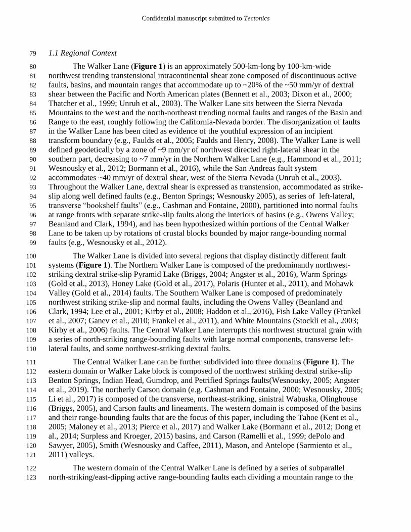
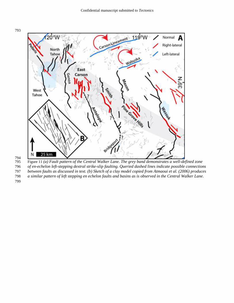
794 Figure 11 (a) Fault pattern of the Central Walker Lane. The grey band demonstrates a well-defined zone 795
of en-echelon left-stepping dextral strike-slip faulting. Queried dashed lines indicate possible connections 796
between faults as discussed in text. (b) Sketch of a clay model copied from Atmaoui et al. (2006) produces 797
a similar pattern of left stepping en echelon faults and basins as is observed in the Central Walker Lane. 798
799

Confidential manuscript submitted to Tectonics
4.3 On the lack of strike-slip in the Central Walker Lane 800
A paleomagnetic survey of the region completed by Carlson (2017) suggests that little 801
rotation has occurred between Antelope, Smith, and Mason valleys, while considerable rotations 802
have accumulated in the Carson domain. The lack of rotation between Antelope and Mason 803
valleys is further supported by the displacement distribution plots in Figure 10: if mountain 804
ranges were actively rotating in a clockwise direction, and this rotation were accommodated by 805
the rangefront faults, it might be expected that slip during earthquakes along the ranges would be 806
distributed such that the largest displacements would occur near the northernmost or 807
southernmost parts of the ranges with lesser displacements in the central portions. Repeated 808
earthquakes with this distribution would result in greater structural relief at the northern and 809
southern parts of ranges, but neither of these patterns are observed, and instead displacement 810
distributions are relatively uniform with the highest relief being generally near the central 811
portions of ranges. Strike-slip faulting should therefore accommodate any shear between these 812
basins in the absence of significant rotations. 813
Well defined active strike-slip faults are observed in the Walker Lake basin (e.g. Dong et 814
al., 2014), Truckee basin (Polaris fault; Hunter et al., 2011) and in the southern part of Mason 815
Valley (Figure 11a). Despite the absence of discrete measurable offsets, the geometry of the 816
Smith Valley range front fault allows that the rangefront fault accommodates a significant 817
portion of right-lateral shear (Figure 5). DePolo and Sawyer (2005) report observing strike-slip 818
faulting in the East Carson Valley fault zone (Figure 11a), though the rate of slip across this 819
broad and complex zone of discontinuous faults remains undefined. The short, northeast-striking 820
faults of the North Tahoe fault system (labeled North Tahoe in Figure 11a, including the 821
Stateline, Incline Village, Little Valley, and Washoe Valley faults) form an en-echelon right 822
stepping pattern (Figure 11a) and may be considered book-shelf faults (e.g., Tapponnier et al., 823
1990), accommodating northwest-directed dextral shear. Thus, while slip rate indicators are not 824
consistently preserved or recognized along all rangefronts and adjacent valleys, the geometry and 825
pattern of faulting along with the distribution of late Quaternary slip as a function of fault strike 826
indicates that there is a significantly larger portion of shear being accommodated by active 827
strike-slip fault displacements than we have yet been able to quantify. 828
829

Confidential manuscript submitted to Tectonics
830
Figure 12. (a) 831
Comparison of dextral 832
shear rates measured 833
across the Walker 834
Lane in various 835
profiles (gray boxes) 836
by GPS (bold 837
numbers), and on 838
individual faults 839
(smaller numbers), in 840
mm/yr (fault slip rates 841
from: Kirby et al., 842
2006; Guest et al., 843
2007; Frankel et al., 844
2011; Hunter et al., 845
2011; Amos et al., 846
2013; Gold Ryan D. et 847
al., 2013; Dong et al., 848
2014; Gold et al., 849
2014; Angster et al., 850
2016; Choi, 2016; 851
Frankel et al., 2016; 852
Haddon et al., 2016; 853
Gold et al., 2017). 854
These GPS rates were 855
provided by J. 856
Bormann and are 857
contained in Redwine 858
et al. (2015). The 859
percentages are taken 860
by summing the rates 861
of individual faults in 862
each profile and 863
dividing those by the 864
total geodetic rate in 865
each profile. There is 866
good agreement 867
between geodetic and 868
geologic observations 869
in the Southern Walker 870
Lane, but less so in the 871
Central and Northern 872
Walker Lane. Major 873
strike-slip fault zone discussed in this paper is highlighted by bold red lines with fault abbreviations: 874
FLV-Fish Lake Valley, WL-Walker Lake, PGH-Pine Grove Hills, SV-Smith Valley, ECV-East Carson 875
Valley, NT-North Tahoe, PF- Polaris Fault, MVF-Mohawk Valley. (b) Oblique oriented map of 876
California and Nevada showing the trend of these faults as a bold black line (right) that is subparallel to 877
the San Andreas (left black line). 878
879
Figure 12

Confidential manuscript submitted to Tectonics
4.4 Geometry of an incipient strike-slip system 880
The grey band in Figure 11a highlights the series of fault systems described in the 881
preceding section. Each of these six fault systems is ~25-km-long, and is separated from its 882
neighboring strike-slip faults by left steps ranging in size from ~15 to 25 km. Together these 883
fault systems form a clear en-echelon left-stepping ~25-km-wide pattern of active dextral faults 884
extending for ~200 km from south of Walker Lake to north of Lake Tahoe. 885
The pattern of faults presented in Figure 11a is consistent with the early stages of models 886
of distributed strike-slip fault systems (e.g., Schreurs, 2003; Hatem et al., 2017) such as shown in 887
Figure 11b. This model produces a discontinuous pattern of left-stepping Riedel shears that form 888
en-echelon extensional basins and dextral faults similar to what is observed in the Central 889
Walker Lane (Atmaoui et al., 2006). All of the faults in these models begin as extensional cracks. 890
Aydin and Nur (1982) show that pull-apart basins in a strike-slip system are largely a result of 891
step overs of en-echelon strike-slip faults, which is consistent with the pattern of faulting 892
observed in the Central Walker Lane. Thus, the majority of north-striking normal faulting along 893
a number of the ranges in this region is driven by northwest directed dextral shear along discrete 894
faults, similar to these experimental models (e.g., Aydin and Nur, 1982; Atmaoui et al., 2006). In 895
this light the westward decrease in inception age and total magnitude of extension and normal 896
faulting from the Wassuk Range to the Sierra Nevada may be evidence for the encroachment of 897
strike-slip faulting through this region. 898
When viewed in large scale the pattern of strike-slip faulting in the Central Walker Lane 899
falls on strike with both the Mohawk Valley and the Death Valley/Fish Lake Valley faults 900
(Figures 1, 12), which are among the most active strike-slip faults of the Northern and Southern 901
Walker Lane, respectively. Laboratory models predict that as displacement accumulates across 902
fault systems, initial distributed faulting will eventually organize into a single through going 903
strike-slip fault. The trend of faults illustrated by the right bold line in Figure 12b forms a linear, 904
>500-km-long fault zone that is nearly parallel to the San Andreas fault, and eventually this may 905
be the trace of a continuous strike-slip fault, accommodating much of the strain across the 906
Pacific-North American plate boundary. However, fault complexity is not solely a result of total 907
shear accumulated across a fault zone, as faults largely take advantage of pre-existing crustal 908
weaknesses (e.g., Molnar, 1988; Ziegler et al., 1998; Matenco et al., 2007; Dyksterhuis and 909
Müller, 2008; Aitken et al., 2013; Raimondo et al., 2014; Calzolari et al., 2016), which in the 910
Walker Lane may have been inherited from an earlier episode of Basin and Range extension, 911
prior to initiation of the current Walker Lane strain regime (Surpless et al., 2002), or even earlier 912
structural irregularities (e.g. Faulds and Henry, 2008). 913
The nuances in the structural evolution of transtensional systems are highlighted here by 914
two other transtensional fault systems that are analogous to the Walker Lane: the Shanxi Rift 915
system of China, and the Aegean-West Anatolian extensional province of Turkey (Figure 13). 916
The Shanxi Rift forms a ~650-km-long by 100-km-wide zone of discontinuous northeast 917
trending normal and strike-slip faults, where the relatively stable Ordos block is moving 918
obliquely relative to the North China plain (Figure 13b) at a current relative geodetic rate of ~2 919
mm/yr (Zhao et al., 2017). While the Shanxi Rift has only accumulated ~10 km of total shear 920
(Xu et al., 1993), much less than the Walker Lane, these two systems have similar fault patterns 921
of discontinuous, en-echelon strike-slip and normal faults. The Aegean-West Anatolian 922
extensional province (Figure 13c) of Turkey is a complex series of strike-slip and normal faults 923
extending to the south of the North Anatolia fault (e.g. Faulds et al., 2009). A north-south 924
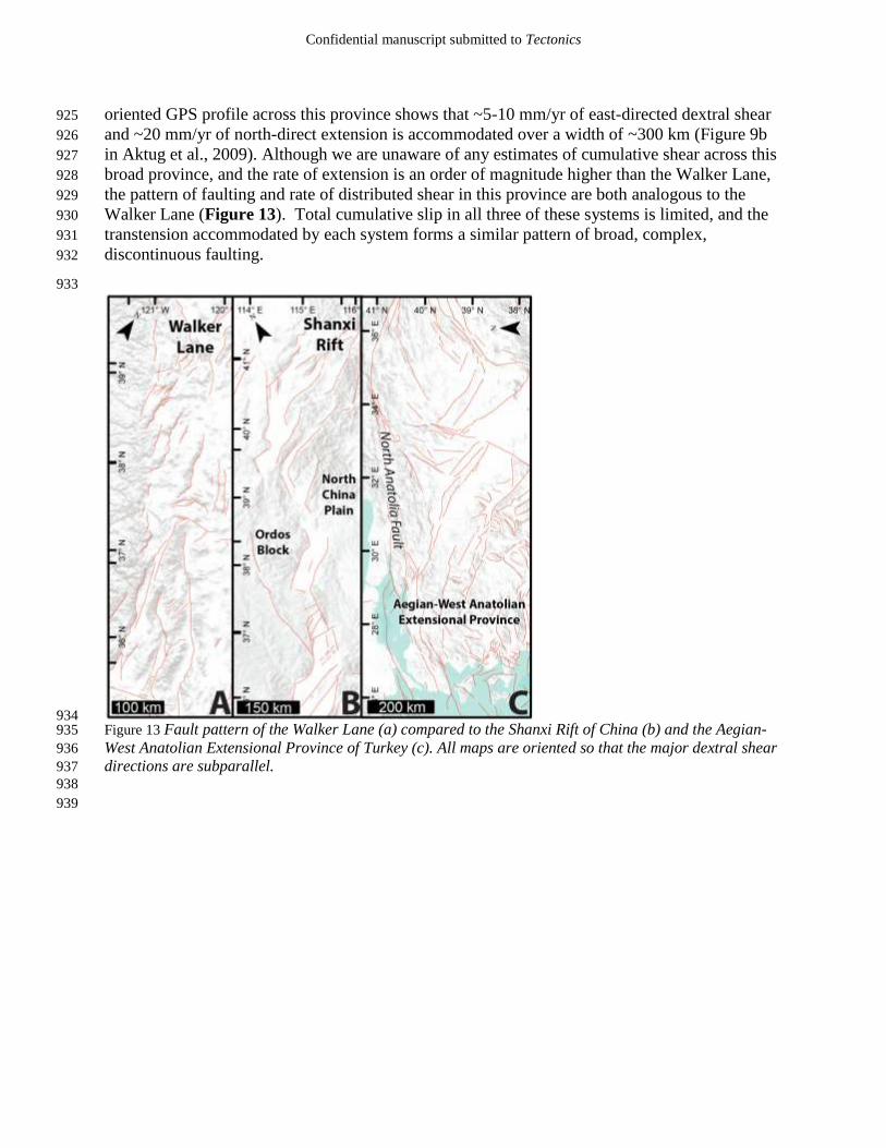
Confidential manuscript submitted to Tectonics
oriented GPS profile across this province shows that ~5-10 mm/yr of east-directed dextral shear 925
and ~20 mm/yr of north-direct extension is accommodated over a width of ~300 km (Figure 9b 926
in Aktug et al., 2009). Although we are unaware of any estimates of cumulative shear across this 927
broad province, and the rate of extension is an order of magnitude higher than the Walker Lane, 928
the pattern of faulting and rate of distributed shear in this province are both analogous to the 929
Walker Lane (Figure 13). Total cumulative slip in all three of these systems is limited, and the 930
transtension accommodated by each system forms a similar pattern of broad, complex, 931
discontinuous faulting. 932
933
934 Figure 13 Fault pattern of the Walker Lane (a) compared to the Shanxi Rift of China (b) and the Aegian-935
West Anatolian Extensional Province of Turkey (c). All maps are oriented so that the major dextral shear 936
directions are subparallel. 937
938
939

Confidential manuscript submitted to Tectonics
5 Conclusions 940
Slip rates of normal faulting for the Antelope, Smith, and Mason valley rangefront 941
faults are 0.6 +0.7/-0.3, 0.7 +1.0/-0.4, and <0.05 mm/yr, respectively. 942
Preservation of geomorphic features indicating strike-slip faulting are lacking 943
along the Antelope and Mason valley rangefront faults. 944
A large component of strike slip is indicated along the Smith Valley fault by a 945
correlation of scarp size and preservation to variations in fault strike. 946
Scarp height distributions measured from lidar along the Smith and Antelope 947
valley range bounding faults agree well with observations from previous 948
paleoseismic trenches, with single event displacements of ~3 m for both faults 949
that correspond with earthquakes of ~Mw 7. 950
Discrete strike-slip faults previously unrecognized are described in the southern 951
parts of Mason Valley and the Walker Lake basin. 952
Significant geodetically observed shear remains unaccounted for by summing 953
geologic slip rates, but is likely accommodated by off-fault deformation and 954
complex rupture patterns. 955
Shear in the western part of the Central Walker Lane is accommodated along a 956
system of short, left-stepping en-echelon dextral and normal faults extending from 957
south of Walker Lake to north of Lake Tahoe. Together this system of faults 958
forms a pattern similar to the initial stages of laboratory models of dextral shear, 959
and may evolve into a through-going strike-slip fault in the future. 960
961
Acknowledgements 962
This research was supported in part by National Science Foundation grant EAR-1419724 963
and EAR-1419789 and by USGS grant G15AP00088. Any use of trade, firm, or product names 964
is for descriptive purposes only and does not imply endorsement. We thank Paula Figueiredo and 965
Sarah Hammer for assistance in processing and calculating TCN ages, and the National Center 966
for Airborne Laser Mapping (NCALM) for collecting lidar data (available at 967
opentopography.org). Thanks to Steve Angster, Tabor Reedy, Chad Carlson, Noah Abramson, 968
Annie Kell, Colin Chupik, Jayne Bormann, Bill Hammond, Ken Adams, and Rachel Hatch for 969
assisting in the field, lab, and numerous enlightening discussions. Thanks to the 2017 UNR 970
Neotectonics class for assistance in the field. Thanks to Rich Koehler for editing an early version 971
of this manuscript. This is Center for Neotectonic Studies contribution number 78. 972
References 973
Adams, K.D., Wesnousky, S.G., 1998. Shoreline processes and the age of the Lake Lahontan 974
highstand in the Jessup embayment, Nevada. Geol. Soc. Am. Bull. 110, 1318–1332. 975
Aitken, A.R.A., Raimondo, T., Capitanio, F.A., 2013. The intraplate character of supercontinent 976
tectonics. Gondwana Res. 24, 807–814. https://doi.org/10.1016/j.gr.2013.03.005 977
Aktug, B., Nocquet, J.M., Cingöz, A., Parsons, B., Erkan, Y., England, P., Lenk, O., Gürdal, 978
M.A., Kilicoglu, A., Akdeniz, H., Tekgül, A., 2009. Deformation of western Turkey from 979

Confidential manuscript submitted to Tectonics
a combination of permanent and campaign GPS data: Limits to block-like behavior. J. 980
Geophys. Res. Solid Earth 114. https://doi.org/10.1029/2008JB006000 981
Ambraseys, N.N., Tchalenko, J.S., 1972. Seismotectonic Aspects of the Gediz, Turkey, 982
Earthquake of March 1970. Geophys. J. R. Astron. Soc. 30, 229–252. 983
https://doi.org/10.1111/j.1365-246X.1972.tb05811.x 984
An, L.-J., Sammis, C.G., 1996. Development of strike-slip faults: shear experiments in granular 985
materials and clay using a new technique. J. Struct. Geol. 18, 1061–1077. 986
https://doi.org/10.1016/0191-8141(96)00012-0 987
Angster, S., Wesnousky, S., Figueiredo, P., Owen, L.A., Hammer, S., 2019. Late Quaternary slip 988
rates for faults of the Central Walker Lane: Spatiotemporal strain release in a strike-slip 989
fault system. Geosphere 57. 990
Angster, S., Wesnousky, S., Huang, W., Kent, G., Nakata, T., Goto, H., 2016. Application of 991
UAV Photography to Refining the Slip Rate on the Pyramid Lake Fault Zone, Nevada. 992
Bull. Seismol. Soc. Am. 106, 785–798. https://doi.org/10.1785/0120150144 993
Atmaoui, N., Kukowski, N., Stöckhert, B., König, D., 2006. Initiation and development of pull-994
apart basins with Riedel shear mechanism: insights from scaled clay experiments. Int. J. 995
Earth Sci. 95, 225–238. https://doi.org/10.1007/s00531-005-0030-1 996
Aydin, A., Nur, A., 1982. Evolution of pull-apart basins and their scale independence. Tectonics 997
1, 91–105. https://doi.org/10.1029/TC001i001p00091 998
Balco, G., Stone, J.O., Lifton, N.A., Dunai, T.J., 2008. A complete and easily accessible means 999
of calculating surface exposure ages or erosion rates from 10Be and 26Al measurements. 1000
Quat. Geochronol. 3, 174–195. https://doi.org/10.1016/j.quageo.2007.12.001 1001
Beanland, S., Clark, M.M., 1994. The Owens Valley Fault Zone, Eastern California, and Surface 1002
Faulting Associated with the 1872 Earthquake (U.S. Geological Survey Bulletin No. 1003
1982). U.S. Geological Survey. 1004
Bell, J.W., Caskey, S.J., Ramelli, A.R., Guerrieri, L., 2004. Pattern and rates of faulting in the 1005
central Nevada seismic belt, and paleoseismic evidence for prior beltlike behavior. Bull. 1006
Seismol. Soc. Am. 94, 1229–1254. 1007
Bell, J.W., dePolo, C.M., Ramelli, A.R., Sarna-Wojcicki, A.M., Meyer, C.E., 1999. Surface 1008
faulting and paleoseismic history of the 1932 Cedar Mountain earthquake area, west-1009
central Nevada, and implications for modern tectonics of the Walker Lane. Geol. Soc. 1010
Am. Bull. 111, 791–807. https://doi.org/10.1130/0016-1011
7606(1999)111<0791:SFAPHO>2.3.CO;2 1012
Bennett, R.A., Wernicke, B.P., Niemi, N.A., Friedrich, A.M., Davis, J.L., 2003. Contemporary 1013
strain rates in the northern Basin and Range province from GPS data. Tectonics 22, 31 1014
pp. https://doi.org/10.1029/2001TC001355 1015
Borchers, B., Marrero, S., Balco, G., Caffee, M., Goehring, B., Lifton, N., Nishiizumi, K., 1016
Phillips, F., Schaefer, J., Stone, J., 2016. Geological calibration of spallation production 1017
rates in the CRONUS-Earth project. Quat. Geochronol. 31, 188–198. 1018
https://doi.org/10.1016/j.quageo.2015.01.009 1019
Bormann, J.M., Hammond, W.C., Kreemer, C., Blewitt, G., 2016. Accommodation of missing 1020
shear strain in the Central Walker Lane, western North America: Constraints from dense 1021
GPS measurements. Earth Planet. Sci. Lett. 440, 169–177. 1022
https://doi.org/10.1016/j.epsl.2016.01.015 1023

Confidential manuscript submitted to Tectonics
Bormann, J.M., Surpless, B.E., Caffee, M.W., Wesnousky, S.G., 2012. Holocene Earthquakes 1024
and Late Pleistocene Slip-Rate Estimates on the Wassuk Range Fault Zone, Nevada. 1025
Bull. Seismol. Soc. Am. 102, 1884–1891. https://doi.org/10.1785/0120110287 1026
Briggs, R.W., 2005. Late Pleistocene and Holocene Paleoearthquake Activity of the Olinghouse 1027
Fault Zone, Nevada. Bull. Seismol. Soc. Am. 95, 1301–1313. 1028
https://doi.org/10.1785/0120040129 1029
Briggs, R.W., 2004. Late Pleistocene fault slip rate, earthquake recurrence, and recency of slip 1030
along the Pyramid Lake fault zone, northern Walker Lane, United States. J. Geophys. 1031
Res. 109. https://doi.org/10.1029/2003JB002717 1032
Calzolari, G., Rossetti, F., Seta, M.D., Nozaem, R., Olivetti, V., Balestrieri, M.L., Cosentino, D., 1033
Faccenna, C., Stuart, F.M., Vignaroli, G., 2016. Spatio-temporal evolution of intraplate 1034
strike-slip faulting: The Neogene–Quaternary Kuh-e-Faghan Fault, central Iran. GSA 1035
Bull. 128, 374–396. https://doi.org/10.1130/B31266.1 1036
Carlson, C., 2017. Kinematics and Transfer Mechanisms of Strain Accommodation at the 1037
Transition between the Northern and Central Walker Lane, Western Nevada (Doctoral 1038
Dissertation). University of Nevada, Reno, Reno, NV. 1039
Cashman, P.H., Fontaine, S.A., 2000. Strain partitioning in the northern Walker Lane, western 1040
Nevada and northeastern California. Tectonophysics 326, 111–130. 1041
dePolo, C.M., Sawyer, T., 2005. Paleoseismic studies along the Eastern Carson Valley fault 1042
system (Final Technical Report), U.S. Geological Survey National Hazards Reduction 1043
Program. 1044
Dixon, T.H., Miller, M., Farina, F., Wang, H., Johnson, D., 2000. Present-day motion of the 1045
Sierra Nevada block and some tectonic implications for the Basin and Range province, 1046
North American Cordillera. Tectonics 19, 1–24. 1047
Dong, S., Ucarkus, G., Wesnousky, S.G., Maloney, J., Kent, G., Driscoll, N., Baskin, R., 2014. 1048
Strike-slip faulting along the Wassuk Range of the northern Walker Lane, Nevada. 1049
Geosphere 10, 40–48. 1050
Dyksterhuis, S., Müller, R.D., 2008. Cause and evolution of intraplate orogeny in Australia. 1051
Geology 36, 495–498. https://doi.org/10.1130/G24536A.1 1052
Faulds, J.E., Bouchot, V., Moeck, I., Oguz, K., 2009. Structural Controls on Geothermal Systems 1053
in Western Turkey: A Preliminary Report 33, 8. 1054
Faulds, J.E., Henry, C.D., 2008. Tectonic influences on the spatial and temporal evolution of the 1055
Walker Lane: An incipient transform fault along the evolving Pacific – North American 1056
plate boundary 34. 1057
Faulds, J.E., Henry, C.D., Hinz, N.H., 2005. Kinematics of the northern Walker Lane: An 1058
incipient transform fault along the Pacific–North American plate boundary. Geology 33, 1059
505–508. 1060
Frankel, K.L., Dolan, J.F., Finkel, R.C., Owen, L.A., Hoeft, J.S., 2007. Spatial variations in slip 1061
rate along the Death Valley-Fish Lake Valley fault system determined from LiDAR 1062
topographic data and cosmogenic 10Be geochronology. Geophys. Res. Lett. 34. 1063
https://doi.org/10.1029/2007GL030549 1064
Frankel, K.L., Dolan, J.F., Owen, L.A., Ganev, P., Finkel, R.C., 2011. Spatial and temporal 1065
constancy of seismic strain release along an evolving segment of the Pacific–North 1066
America plate boundary. Earth Planet. Sci. Lett. 304, 565–576. 1067
https://doi.org/10.1016/j.epsl.2011.02.034 1068

Confidential manuscript submitted to Tectonics
Ganev, P.N., Dolan, J.F., Frankel, K.L., Finkel, R.C., 2010. Rates of extension along the Fish 1069
Lake Valley fault and transtensional deformation in the Eastern California shear zone–1070
Walker Lane belt. Lithosphere 2, 33–49. https://doi.org/10.1130/L51.1 1071
Gilbert, C.M., Reynolds, M.W., 1973. Character and Chronology of Basin Development, 1072
Western Margin of the Basin and Range Province. Geol. Soc. Am. Bull. 84, 2489. 1073
https://doi.org/10.1130/0016-7606(1973)84<2489:CACOBD>2.0.CO;2 1074
Gold, R., dePolo, C., Briggs, R., Crone, A., Gosse, J., 2013. Late Quaternary Slip‐Rate 1075
Variations along the Warm Springs Valley Fault System, Northern Walker Lane, 1076
California–Nevada Border. Bull. Seismol. Soc. Am. 103, 542–558. 1077
https://doi.org/10.1785/0120120020 1078
Gold, R.D., Briggs, R.W., Crone, A.J., DuRoss, C.B., 2017. Refining fault slip rates using 1079
multiple displaced terrace risers—An example from the Honey Lake fault, NE California, 1080
USA. Earth Planet. Sci. Lett. 477, 134–146. https://doi.org/10.1016/j.epsl.2017.08.021 1081
Gold, R.D., Briggs, R.W., Personius, S.F., Crone, A.J., Mahan, S.A., Angster, S.J., 2014. Latest 1082
Quaternary paleoseismology and evidence of distributed dextral shear along the Mohawk 1083
Valley fault zone, northern Walker Lane, California: Paleoseismology Mohawk Valley 1084
fault zone. J. Geophys. Res. Solid Earth 119, 5014–5032. 1085
https://doi.org/10.1002/2014JB010987 1086
Gold, R.D., Reitman, N.G., Briggs, R.W., Barnhart, W.D., Hayes, G.P., Wilson, E., 2015. On- 1087
and off-fault deformation associated with the September 2013 Mw 7.7 Balochistan 1088
earthquake: Implications for geologic slip rate measurements. Tectonophysics. 1089
https://doi.org/10.1016/j.tecto.2015.08.019 1090
Gosse, J.C., Phillips, F.M., 2001. Terrestrial in situ cosmogenic nuclides: theory and application. 1091
Quat. Sci. Rev. 20, 1475–1560. 1092
Gourmelen, N., Dixon, T.H., Amelung, F., Schmalzle, G., 2011. Acceleration and evolution of 1093
faults: An example from the Hunter Mountain–Panamint Valley fault zone, Eastern 1094
California. Earth Planet. Sci. Lett. 301, 337–344. 1095
https://doi.org/10.1016/j.epsl.2010.11.016 1096
Guest, B., Niemi, N., Wernicke, B., 2007. Stateline fault system: A new component of the 1097
Miocene-Quaternary Eastern California shear zone. GSA Bull. 119, 1337–1347. 1098
https://doi.org/10.1130/0016-7606(2007)119[1337:SFSANC]2.0.CO;2 1099
Haddon, E.K., Amos, C.B., Zielke, O., Jayko, A.S., Bürgmann, R., 2016. Surface slip during 1100
large Owens Valley earthquakes. Geochem. Geophys. Geosystems 17, 2239–2269. 1101
https://doi.org/10.1002/2015GC006033 1102
Hamling, I.J., Hreinsdóttir, S., Clark, K., Elliott, J., Liang, C., Fielding, E., Litchfield, N., 1103
Villamor, P., Wallace, L., Wright, T.J., D’Anastasio, E., Bannister, S., Burbidge, D., 1104
Denys, P., Gentle, P., Howarth, J., Mueller, C., Palmer, N., Pearson, C., Power, W., 1105
Barnes, P., Barrell, D.J.A., Dissen, R.V., Langridge, R., Little, T., Nicol, A., Pettinga, J., 1106
Rowland, J., Stirling, M., 2017. Complex multifault rupture during the 2016 Mw 7.8 1107
Kaikōura earthquake, New Zealand. Science 356, eaam7194. 1108
https://doi.org/10.1126/science.aam7194 1109
Hammond, W.C., Blewitt, G., Kreemer, C., 2011. Block modeling of crustal deformation of the 1110
northern Walker Lane and Basin and Range from GPS velocities. J. Geophys. Res. 116. 1111
https://doi.org/10.1029/2010JB007817 1112
Confidential manuscript submitted to Tectonics
Hammond, W.C., Thatcher, W., 2007. Crustal deformation across the Sierra Nevada, northern 1113
Walker Lane, Basin and Range transition, western United States measured with GPS, 1114
2000–2004. J. Geophys. Res. 112. https://doi.org/10.1029/2006JB004625 1115
Hammond, W.C., Thatcher, W., 2005. Northwest Basin and Range tectonic deformation 1116
observed with the Global Positioning System, 1999–2003. J. Geophys. Res. 110. 1117
https://doi.org/10.1029/2005JB003678 1118
Hanks, T.C., Kanamori, H., 1979. A moment magnitude scale. J. Geophys. Res. Solid Earth 84, 1119
2348–2350. https://doi.org/10.1029/JB084iB05p02348 1120
Hatem, A.E., Cooke, M.L., Toeneboehn, K., 2017. Strain localization and evolving kinematic 1121
efficiency of initiating strike-slip faults within wet kaolin experiments. J. Struct. Geol. 1122
101, 96–108. https://doi.org/10.1016/j.jsg.2017.06.011 1123
Hecker, S., Dawson, T.E., Schwartz, D.P., 2010. Normal-Faulting Slip Maxima and Stress-Drop 1124
Variability: A Geological PerspectiveNormal-Faulting Slip Maxima and Stress-Drop 1125
Variability: A Geological Perspective. Bull. Seismol. Soc. Am. 100, 3130–3147. 1126
https://doi.org/10.1785/0120090356 1127
Herbert, J.W., Cooke, M.L., Oskin, M., Difo, O., 2014. How much can off-fault deformation 1128
contribute to the slip rate discrepancy within the eastern California shear zone? Geology 1129
42, 71–75. https://doi.org/10.1130/g34738.1 1130
Hidy, A.J., Gosse, J.C., Pederson, J.L., Mattern, J.P., Finkel, R.C., 2010. A geologically 1131
constrained Monte Carlo approach to modeling exposure ages from profiles of 1132
cosmogenic nuclides: An example from Lees Ferry, Arizona. Geochem. Geophys. 1133
Geosystems 11. https://doi.org/10.1029/2010GC003084 1134
Hunter, L.E., Howle, J.F., Rose, R.S., Bawden, G.W., 2011. LiDAR-Assisted Identification of an 1135
Active Fault near Truckee, California. Bull. Seismol. Soc. Am. 101, 1162–1181. 1136
https://doi.org/10.1785/0120090261 1137
Kaneda, H., Okada, A., 2008. Long-Term Seismic Behavior of a Fault Involved in a Multiple-1138
Fault Rupture: Insights from Tectonic Geomorphology along the Neodani Fault, Central 1139
Japan. Bull. Seismol. Soc. Am. 98, 2170–2190. https://doi.org/10.1785/0120070204 1140
Kent, G.M., Babcock, J.M., Driscoll, N.W., Harding, A.J., Dingler, J.A., Seitz, G.G., Gardner, 1141
J.V., Mayer, L.A., Goldman, C.R., Heyvaert, A.C., Richards, R.C., Karlin, R., Morgan, 1142
C.W., Gayes, P.T., Owen, L.A., 2005. 60 k.y. record of extension across the western 1143
boundary of the Basin and Range province: Estimate of slip rates from offset shoreline 1144
terraces and a catastrophic slide beneath Lake Tahoe. Geology 33, 365–368. 1145
https://doi.org/10.1130/G21230.1 1146
Kirby, E., Anandakrishnan, S., Phillips, F., Marrero, S., 2008. Late Pleistocene slip rate along the 1147
Owens Valley fault, eastern California. Geophys. Res. Lett. 35. 1148
https://doi.org/10.1029/2007GL031970 1149
Kirby, E., Burbank, D.W., Reheis, M., Phillips, F., 2006. Temporal variations in slip rate of the 1150
White Mountain Fault Zone, Eastern California. Earth Planet. Sci. Lett. 248, 168–185. 1151
https://doi.org/10.1016/j.epsl.2006.05.026 1152
Koehler, R.D., Wesnousky, S.G., 2011. Late Pleistocene regional extension rate derived from 1153
earthquake geology of late Quaternary faults across the Great Basin, Nevada, between 1154
38.5° N and 40° N latitude. Geol. Soc. Am. Bull. 123, 631–650. 1155
Kohl, C.P., Nishiizumi, K., 1992. Chemical isolation of quartz for measurement of in-situ-1156
produced cosmogenic nuclides. Geochim. Cosmochim. Acta 56, 3583–3587. 1157
Confidential manuscript submitted to Tectonics
Lal, D., 1991. Cosmic ray labeling of erosion surfaces: in situ nuclide production rates and 1158
erosion models. Earth Planet. Sci. Lett. 104, 424–439. 1159
Lee, J., Spencer, J., Owen, L., 2001. Holocene slip rates along the Owens Valley fault, 1160
California: Implications for the recent evolution of the Eastern California Shear Zone. 1161
Geology 29, 819–822. https://doi.org/10.1130/0091-1162
7613(2001)029<0819:HSRATO>2.0.CO;2 1163
Li, X., Huang, W., Pierce, I.K.D., Angster, S.J., Wesnousky, S.G., 2017. Characterizing the 1164
Quaternary expression of active faulting along the Olinghouse, Carson, and Wabuska 1165
lineaments of the Walker Lane. Geosphere 13, 2119–2136. 1166
https://doi.org/10.1130/GES01483.1 1167
Lifton, N., 2016. Implications of two Holocene time-dependent geomagnetic models for 1168
cosmogenic nuclide production rate scaling. Earth Planet. Sci. Lett. 433, 257–268. 1169
https://doi.org/10.1016/j.epsl.2015.11.006 1170
Link, M.H., Roberts, M.T., Newton, M.S., 1985. Walker Lake Basin, Nevada: An Example of 1171
Late Tertiary (?) to Recent Sedimentation in a Basin Adjacent to an Active Strike-Slip 1172
Fault, in: Strike-Slip Deformation, Basin Formation, and Sedimentation. Society for 1173
Sedimentary Geology. 1174
Maloney, J.M., Noble, P.J., Driscoll, N.W., Kent, G.M., Smith, S.B., Schmauder, G.C., Babcock, 1175
J.M., Baskin, R.L., Karlin, R., Kell, A.M., Seitz, G.G., Zimmerman, S., Kleppe, J.A., 1176
2013. Paleoseismic history of the Fallen Leaf segment of the West Tahoe-Dollar Point 1177
fault reconstructed from slide deposits in the Lake Tahoe Basin, California-Nevada. 1178
Geosphere 9, 1065–1090. https://doi.org/10.1130/GES00877.1 1179
Mann, P., 2007. Global catalogue, classification and tectonic origins of restraining- and releasing 1180
bends on active and ancient strike-slip fault systems. Geol. Soc. Lond. Spec. Publ. 290, 1181
13–142. https://doi.org/10.1144/SP290.2 1182
Martin, L.C.P., Blard, P.-H., Balco, G., Lavé, J., Delunel, R., Lifton, N., Laurent, V., 2017. The 1183
CREp program and the ICE-D production rate calibration database: A fully 1184
parameterizable and updated online tool to compute cosmic-ray exposure ages. Quat. 1185
Geochronol. 38, 25–49. https://doi.org/10.1016/j.quageo.2016.11.006 1186
Matenco, L., Bertotti, G., Leever, K., Cloetingh, S., Schmid, S.M., Tărăpoancă, M., Dinu, C., 1187
2007. Large-scale deformation in a locked collisional boundary: Interplay between 1188
subsidence and uplift, intraplate stress, and inherited lithospheric structure in the late 1189
stage of the SE Carpathians evolution. Tectonics 26. 1190
https://doi.org/10.1029/2006TC001951 1191
Molnar, P., 1988. Continental tectonics in the aftermath of plate tectonics. Nature 335, 131. 1192
https://doi.org/10.1038/335131a0 1193
Myers, W.B., Hamilton, W., 1964. The Hebgen Lake, Montana, earthquake of August 17, 1959 1194
(No. 435– I), Geological Survey Professional Paper. 1195
Nishiizumi, K., Winterer, E.L., Kohl, C.P., Klein, J., Middleton, R., Lal, D., Arnold, J.R., 1989. 1196
Cosmic ray production rates of 10Be and 26Al in quartz from glacially polished rocks. J. 1197
Geophys. Res. Solid Earth 94, 17907–17915. https://doi.org/10.1029/JB094iB12p17907 1198
Oskin, M.E., Arrowsmith, J.R., Corona, A.H., Elliott, A.J., Fletcher, J.M., Fielding, E.J., Gold, 1199
P.O., Garcia, J.J.G., Hudnut, K.W., Liu-Zeng, J., Teran, O.J., 2012. Near-Field 1200
Deformation from the El Mayor–Cucapah Earthquake Revealed by Differential LIDAR. 1201
Science 335, 702–705. https://doi.org/10.1126/science.1213778 1202

Confidential manuscript submitted to Tectonics
Personius, S.F., Briggs, R.W., Maharrey, J.Z., Angster, S.J., Mahan, S.A., 2017. A paleoseismic 1203
transect across the northwestern Basin and Range Province, northwestern Nevada and 1204
northeastern California, USA. Geosphere 13, 782–810. 1205
https://doi.org/10.1130/GES01380.1 1206
Pierce, I.K.D., Wesnousky, S.G., Owen, L.A., 2017. Terrestrial cosmogenic surface exposure 1207
dating of moraines at Lake Tahoe in the Sierra Nevada of California and slip rate 1208
estimate for the West Tahoe Fault. Geomorphology 298, 63–71. 1209
https://doi.org/10.1016/j.geomorph.2017.09.030 1210
Raimondo, T., Hand, M., Collins, W.J., 2014. Compressional intracontinental orogens: Ancient 1211
and modern perspectives. Earth-Sci. Rev. 130, 128–153. 1212
https://doi.org/10.1016/j.earscirev.2013.11.009 1213
Ramelli, A.R., Bell, J.W., dePolo, C.M., Yount, J.C., 1999. Large-magnitude, late Holocene 1214
earthquakes on the Genoa fault, west-central Nevada and eastern California. Bull. 1215
Seismol. Soc. Am. 89, 1458–1472. 1216
Redwine, J., Wakabayashi, J., Sawyer, T., Bormann, J.M., Kemp, C., Humphrey, J., Unruh, J., 1217
Briggs, R.W., Adams, K.D., Ramelli, A.R., Gold, R.D., Burke, R.M., 2015. The 2015 1218
Annual Pacific Cell Friends of the Pleistocene field trip. From Mohawk Valley to 1219
Caribou Junction Middle and North Forks of the Feather River, northeastern California 1220
(Field Trip Guide). 1221
Reheis, M., 1999. Extent of Pleistocene Lakes in the Western Great Basin. Miscellaneous Field 1222
Studies. 1223
Rittase, W.M., Kirby, E., McDonald, E., Walker, J.D., Gosse, J., Spencer, J.Q.G., Herrs, A.J., 1224
2014. Temporal variations in Holocene slip rate along the central Garlock fault, Pilot 1225
Knob Valley, California. Lithosphere 6, 48–58. https://doi.org/10.1130/L286.1 1226
Rood, D.H., Burbank, D.W., Finkel, R.C., 2011. Spatiotemporal patterns of fault slip rates across 1227
the Central Sierra Nevada frontal fault zone. Earth Planet. Sci. Lett. 301, 457–468. 1228
https://doi.org/10.1016/j.epsl.2010.11.006 1229
Sarmiento, A.C., Wesnousky, S.G., Bormann, J.M., 2011. Paleoseismic Trenches across the 1230
Sierra Nevada and Carson Range Fronts in Antelope Valley, California, and Reno, 1231
Nevada. Bull. Seismol. Soc. Am. 101, 2542–2549. https://doi.org/10.1785/0120100176 1232
Schreurs, G., 2003. Fault development and interaction in distributed strike-slip shear zones: an 1233
experimental approach. Geol. Soc. Lond. Spec. Publ. 210, 35–52. 1234
https://doi.org/10.1144/GSL.SP.2003.210.01.03 1235
Seitz, G.G., Kent, G., 2014. Closing the Gap between on and Offshore Paleoseismic Records in 1236
the Lake Tahoe Basin (Final Technical Report), U.S. Geological Survey National 1237
Hazards Reduction Program. 1238
Stauffer, H., 2003. Timing of the Last Highstand of Pluvial Lake Wellington, Smith Valley, 1239
Nevada (Master’s Thesis). San Jose State University. 1240
Stirling, M.W., Wesnousky, S.G., Shimazaki, K., 1996. Fault trace complexity, cumulative slip, 1241
and the shape of the magnitude-frequency distribution for strike-slip faults: a global 1242
survey. Geophys. J. Int. 124, 833–868. https://doi.org/10.1111/j.1365-1243
246X.1996.tb05641.x 1244
Stockli, D.F., Dumitru, T.A., McWilliams, M.O., Farley, K.A., 2003. Cenozoic tectonic 1245
evolution of the White Mountains, California and Nevada. Geol. Soc. Am. Bull. 115, 1246
788–816. 1247

Confidential manuscript submitted to Tectonics
Stone, J.O., 2000. Air pressure and cosmogenic isotope production. J. Geophys. Res. 105, 1248
23,753-23,759. 1249
Surpless, B., Kroeger, G., 2015. The unusual temporal and spatial slip history of the Wassuk 1250
Range normal fault, western Nevada (USA): Implications for seismic hazard and Walker 1251
Lane deformation. Geol. Soc. Am. Bull. 127, 737–758. https://doi.org/10.1130/B31159.1 1252
Surpless, B.E., Stockli, D.F., Dumitru, T.A., Miller, E.L., 2002. Two-phase westward 1253
encroachment of Basin and Range extension into the northern Sierra Nevada. Tectonics 1254
21, 2-1-2–10. https://doi.org/10.1029/2000tc001257 1255
Tapponnier, P., Armijo, R., Manighetti, I., Courtillot, V., 1990. Bookshelf faulting and 1256
horizontal block rotations between overlapping rifts in southern Afar. Geophys. Res. Lett. 1257
17, 1–4. https://doi.org/10.1029/GL017i001p00001 1258
Thatcher, W., Foulger, G.R., Julian, B.R., Svarc, J., Quilty, E., Bawden, G.W., 1999. Present-1259
Day Deformation Across the Basin and Range Province, Western United States. Science 1260
283, 1714–1717. 1261
Unruh, J., Humphrey, J., Barron, A., 2003. Transtensional model for the Sierra Nevada frontal 1262
fault system, eastern California. Geology 31, 327–330. 1263
Uppala, S.M., KAllberg, P.W., Simmons, A.J., Andrae, U., Bechtold, V.D.C., Fiorino, M., 1264
Gibson, J.K., Haseler, J., Hernandez, A., Kelly, G.A., Li, X., Onogi, K., Saarinen, S., 1265
Sokka, N., Allan, R.P., Andersson, E., Arpe, K., Balmaseda, M.A., Beljaars, A.C.M., 1266
Berg, L.V.D., Bidlot, J., Bormann, N., Caires, S., Chevallier, F., Dethof, A., Dragosavac, 1267
M., Fisher, M., Fuentes, M., Hagemann, S., H?lm, E., Hoskins, B.J., Isaksen, L., Janssen, 1268
P.A.E.M., Jenne, R., Mcnally, A.P., Mahfouf, J.-F., Morcrette, J.-J., Rayner, N.A., 1269
Saunders, R.W., Simon, P., Sterl, A., Trenberth, K.E., Untch, A., Vasiljevic, D., Viterbo, 1270
P., Woollen, J., 2005. The ERA-40 re-analysis. Q. J. R. Meteorol. Soc. 131, 2961–3012. 1271
https://doi.org/10.1256/qj.04.176 1272
Wesnousky, S.G., 2008. Displacement and Geometrical Characteristics of Earthquake Surface 1273
Ruptures: Issues and Implications for Seismic-Hazard Analysis and the Process of 1274
Earthquake Rupture. Bull. Seismol. Soc. Am. 98, 1609–1632. 1275
https://doi.org/10.1785/0120070111 1276
Wesnousky, S.G., 2005. Active faulting in the Walker Lane. Tectonics 24, 35 pp. 1277
https://doi.org/10.1029/2004TC001645 1278
Wesnousky, S.G., 1988. Seismological and structural evolution of strike-slip faults. Nature 335, 1279
340. https://doi.org/10.1038/335340a0 1280
Wesnousky, S.G., Bormann, J.M., Kreemer, C., Hammond, W.C., Brune, J.N., 2012. 1281
Neotectonics, geodesy, and seismic hazard in the Northern Walker Lane of Western 1282
North America: Thirty kilometers of crustal shear and no strike-slip? Earth Planet. Sci. 1283
Lett. 329–330, 133–140. https://doi.org/10.1016/j.epsl.2012.02.018 1284
Wesnousky, S.G., Caffee, M., 2011. Range-Bounding Normal Fault of Smith Valley, Nevada: 1285
Limits on Age of Last Surface-Rupture Earthquake and Late Pleistocene Rate of 1286
Displacement. Bull. Seismol. Soc. Am. 101, 1431–1437. 1287
https://doi.org/10.1785/0120100238 1288
Wilcox, R.E., Harding, T.P., Seely, D.R., 1973. Basic wrench tectonics. AAPG Bull. 57, 74–96. 1289
Wintle, A.G., Murray, A.S., 2006. A review of quartz optically stimulated luminescence 1290
characteristics and their relevance in single-aliquot regeneration dating protocols. Radiat. 1291
Meas. 41, 369–391. https://doi.org/10.1016/j.radmeas.2005.11.001 1292

Confidential manuscript submitted to Tectonics
Xu, X., Ma, X., Deng, Q., 1993. Neotectonic activity along the Shanxi rift system, China. 1293
Tectonophysics 219, 305–325. https://doi.org/10.1016/0040-1951(93)90180-R 1294
Zechar, J.D., Frankel, K.L., 2009. Incorporating and reporting uncertainties in fault slip rates. J. 1295
Geophys. Res. Solid Earth 114, B12407. https://doi.org/10.1029/2009JB006325 1296
Zhao, B., Zhang, C., Wang, D., Huang, Y., Tan, K., Du, R., Liu, J., 2017. Contemporary 1297
kinematics of the Ordos block, North China and its adjacent rift systems constrained by 1298
dense GPS observations. J. Asian Earth Sci. 135, 257–267. 1299
https://doi.org/10.1016/j.jseaes.2016.12.045 1300
Ziegler, P.A., van Wees, J.-D., Cloetingh, S., 1998. Mechanical controls on collision-related 1301
compressional intraplate deformation. Tectonophysics 300, 103–129. 1302
https://doi.org/10.1016/S0040-1951(98)00236-4 1303
Zinke, R., Dolan, J.F., Dissen, R.V., Grenader, J.R., Rhodes, E.J., McGuire, C.P., Langridge, 1304
R.M., Nicol, A., Hatem, A.E., 2015. Evolution and progressive geomorphic manifestation 1305
of surface faulting: A comparison of the Wairau and Awatere faults, South Island, New 1306
Zealand. Geology 43, 1019–1022. https://doi.org/10.1130/G37065.1 1307
Zuza, A.V., Yin, A., Lin, J., Sun, M., 2017. Spacing and strength of active continental strike-slip 1308
faults. Earth Planet. Sci. Lett. 457, 49–62. https://doi.org/10.1016/j.epsl.2016.09.041 1309
1310