abstract - irdi online features... · 1physics teacher at oniong west secondary school ikot edor,...
TRANSCRIPT

ISSN: 2276-8521 http://www.irdionline.com/catr_article.html
85
International Journal of Research and Advancement in Physical Science, Volume 3, Number 2, 2013
STRUCTURAL FEATURES WITHIN PART OF BORNU BASIN, NORTH-EASTRN NIGERIA, USING SEISMIC DATA
1Udoh, J. S., 2Okwueze, E. E., 3Ilozobhie, A. J. 4Idiong, E. A.
1Physics Teacher at Oniong West Secondary School Ikot Edor, Onna.Akwa Ibom State, Nigeria 2,3Physics Department, University of Calabar, Calabar, Cross River State, Nigeria 4Physics Department, Akwa Ibom State College of Education, Afaha Nsit, Nigeria
ABSTRACT
In the analysis of structural features of this study area, the Bornu basin provides possible source rocks, reservoir beds and structural environment which is required for the formation of hydrocarbon. The thrust of this work is to identify the structural features displayed in the seismic section. The study area lies within the northeast end of Nigeria between latitude 120 19’N and 120 28’N and longitude 130 14’ E and 130 25’E. Two seismic base maps were first merged into a single map. It is from this single seismic base map that analysis was made. Three horizons and three layers were mapped. The two-way –travel time (TWT) for most of the seismic lines ranged from 290miliseconds to 1800 milliseconds. From analysis, multiple folds were seen and the depth of the horizon ranges between 100m to 1990m. The sediment thickness ranging from about 100m to 2100m was found. The presence of identified structural features shows that the basin is capable of having hydrocarbon accumulation as other rifted basins of the world. Further researches into more detailed study of the basin will enhance better productive oil and gas traps reservoirs. Keywords: Seismic Wave, TWT, Isochron map, Isopach map, Isovelocity Map.
INTRODUCTION Subsurface structural maps are the primary tools used by explorationist to search for hydrocarbon from initial stage to the complete development of an oil field (Kofron, et al 1996). Each subsurface map is a geologic or a geophysical interpretation, based on available data, technical proficiency, creative imagination, three dimensional visualization and experience (Tearpock and Bischike, 1991). Seismic wave is an acoustic energy transmitted by vibrations of rock particles. Low energy waves are approximately elastic, leaving the rock mass unchanged by their passage, but close to a seismic source the rock may be shattered and permanently distorted (Milson, 2003). The Bornu Basin is the Nigerian sector of Chad Basin which extends into parts of the Republics of Niger, Chad, Cameroon, Nigeria and Central Africa. The Bornu Basin is about one tenth of the entire Chad Basin and lies between latitudes 100N and 130 N and longitude 100 E and 130E. It is one of the seven sedimentary basins in the country and is the most explored with the exception of the Niger Delta. Active exploration work stated in the Bornu Basin in 1977 following the discovery of commercial quantities of petroleum in the neighbouring Termit Basin of the Republic of Chad. So far 23 wells have been drilled and about 2500km of seismic data have been acquired in the Bornu Basin with virtually no commercial discovery of hydrocarbon despite the Federal Government huge investment in the exploration of oil and gas in this region (Adepelumi et al, 2010). Such exploration failures call for more efficient exploration and interpretation of available data. Really, the search for hydrocarbon in the Bornu Basin has been intensified with the NNPC and other oil companies going back to acquire 3-D seismic data after the initial 2-D seismic data previously acquired. However, an in-depth study of this work would give an adequate knowledge of structural features of the Basin. The study area lies within the Northeast End of Nigeria between latitude 120 19’N and 120 28’N and longitiude 130 10’E and 130 25’E covering an area of about 20 by 40 kilometers square. Correspondent Author: Udoh, J. S., E-mail: [email protected]

ISSN: 2276-8521 http://www.irdionline.com/catr_article.html
86
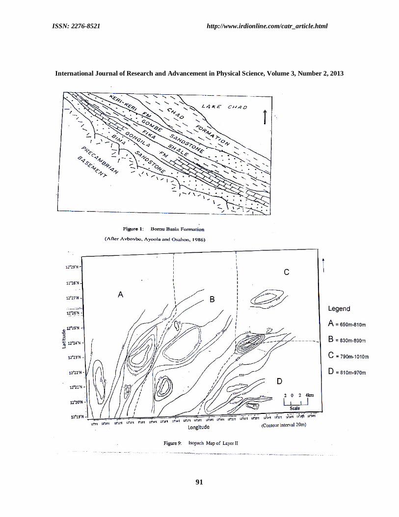
Structural Features within Part of Bornu Basin, North-Eastern Nigeria, using Seismic Data GEOLOGY OF BORNU BASIN The geology of the Bornu Basin according to Mathias (1976) is largely part of the Chad Basin. The statement was confirmed by Adepelumi et al; (2010) and Ajakaiye and Ajayi (1981). The Bornu Basin is a sediment–filled (broad) depression straddling Northeastern Nigeria and adjoining parts of Chad Republic. It is separated from the upper Benue Basin by the Zambuk ridge. The sedimentary rocks have a cumulative thickness of over 3,600 metres and consist of thick basal continental sequence overlain by transitional beds followed by thick succession of Quaternary limnic, fluviatile and eolian sands and clays. Outcrops of older beds are rare as they are covered in most parts by desert-blown sediment (Adepelumi et al; 2010). Bornu Basin has an approximate sediment thickness of more than 10km (Ananaba and Ajakaiye, 1983: and Avbovbo et al; 1980). Six stratigraphic units according to Cater et al; (1963), Avbovbo et al; (1986) and Adepelumi et al; (2010), were recognized. They include Bima Sandstone, Gongila Formation, Fika Shale, Gombe sandstone, Kerri Kerri and Chad Formations. (Figure I). The oldest stratigraphic unit in the area is the Bima sandstone. The formation is feldspathic towards the bottom of the boreholes. Current bedding is an important feature that is observable on the outcrops of the formation. Bima sandstone lies unconformably on the basement complex derived from the degradation of the basement rocks. The Bima represents the upper part of the continental intercalaire in Nigeria (Adepelumi et al; 2010). Basin differentiation probably occurred next leading to variation in facies. The late Cenomonian–early Turonian erosion and folding continue with deposition of Marine transgression which deposited muds, subordinate sands and shale of the Gongila formation in a shallow marine environment. The Gongila formation is regarded as a transitional deposit that accompanied the onset of marine incursions into the basin. Its lithology varies laterally, it consists of a sequence of sandstones, clay, shale, and limestone layers. The maximum thickness recorded for this formation is 1410m (Adepelumi et at; 2010). During the Turonian, bluish-black ammonite-rich open marine shale of Fika formation was deposited till late Cenomonian. The source of marine water during the period is believed to be through the Trans Sahara way, A maximum thickness of 890m has been penetrated by boreholes near Maiduguri. Also present at several horizons of the formation is volcanic intrusives which occur as diorite sills (Okosun, 1995). The regressive phase that followed the end of the cretaceous resulted in the deposition of deltaic lacustrine, clastic sediments of Gombe Formation. The clastic sediments must have been derived form the uplift margin of the trough after Satonian folding episode which affected major basins in Nigeria (Carter et al; 1963; Peters, 1981 and Avbovbo et al;1986). The remnant basin that succeeded the folding episode formed the site for the deposition of the tertiary Kerri-Kerri Formation which rests uncomformably over Gombe Formation. The formation consists of loosely cemented, coarse to fine-grained sandstone, massive clay-stone and siltstone. Bands of ironstone and conglomerate occur locally. The sediments are lacustrine and deltaic in origin and have a maximum thickness of over 200m (Adepelumi et al; 2010). The Chad formation is the youngest stratigraphic unit in the Basin. It is separated by a minor unconformity from the Kerri-Kerri formation. The lower Chad formation had been dated as Paleocene (Peters and Ekweozor, 1982 and Avbovbo et al; 1986). The basin consists of yellow, grey, fine to coarse grained sand with intercalations of sandy clay and diatomites. The formation varies considerably in thickness on the western shore of Lake Chad. It is estimated to be about 800m thick. The formation is underlain by the basement rocks at the periphery of the basin (Adepelumi et al; 2010). MATERIALS AND METHODS The study area is covered with many seismic reflection lines. Thirteen dip lines and ten strike lines trending Northwest-Southeast and Northeast-Southwest directions respectively were considered. Most of these seismic lines were shot around 1955 to 1994. Two base maps were used for this work. The acquisition parameters and the quality of the seismic data supplied were studied by critically examining the seismic section information boxes. They were the visually studied to see whether structural features can easily be seen. Quantitative and qualitative techniques were adopted in the analysis of the data. All the seismic sections are 2-D migrated sections.
ISSN: 2276-8521 http://www.irdionline.com/catr_article.html
87
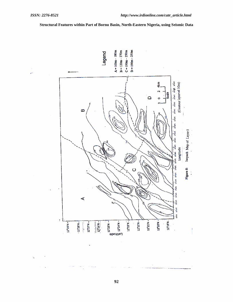
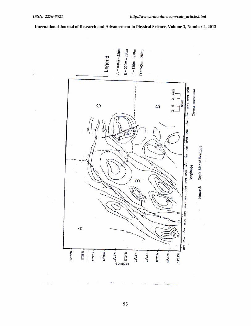
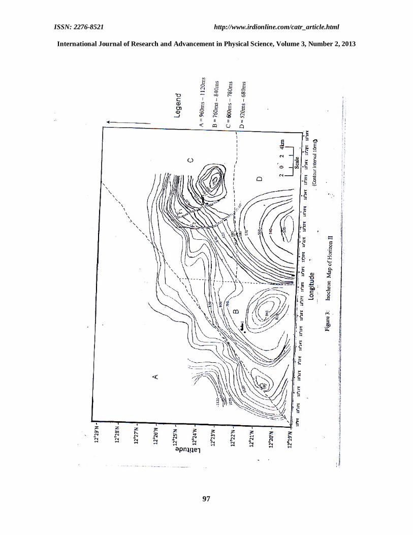
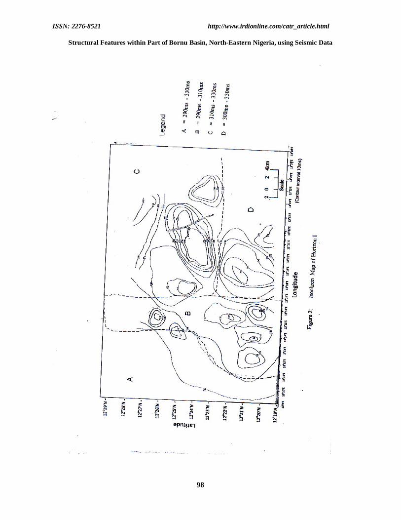
International Journal of Research and Advancement in Physical Science, Volume 3, Number 2, 2013 In order to facilitate structural interpretation from the available seismic sections, the two seismic base maps were first merged into a single map. It is on this resulted seismic base map that the analyses were made. Three horizons were chosen from a strike line with minimum deformation and continuous reflection character. These horizons were traced along the seismic section and as the horizon comes to a crossing line, the crossing line section is folded vertically at the intersection point and aligned with the unfolded section and the horizons were traced on the unfolded section (Grant and West, 1965; Telford et al; 1976 and Dobrin and Savit, 1988). Seismic attribute such as two way time (TWT) was computed for all the lines manually using the vertical scale on the seismic section. The TWT was computed using the equation below (Telford, et al 1976) t =2z/v………………………(1) where; t is the two way travel time z is the depth of reflecting horizons v is the velocity of sequence Other seismic attributes such as depth, thickness and interval velocity were computed and each contoured into geophysical maps. RESULTS AND DISCUSSION The results of the structural features are presented as isochron maps, depth maps, isopach maps and isovelocity maps. Isochron maps Isochron map is a map showing the variation in the difference of the two way time TWT between two seismic reflection event (Wikipedia, 2011). Figure 2 shows the isochron map of horizon I. Along the upper Northeastern part of the map, a rollover structure developed by a major regional fault was depicted. The reflection time for this horizons ranges from 290 to 360 milliseconds. The lower part depicts fold structures that are not well developed. Figure 3 shows the isochron map of horizon II. The map is characterized by multiple drape folded bodies dominating the southern and eastern section of the map. The faulted rollover structure is still distinct. The time interval for this map ranges between 520 to 1120 milliseconds. Figure 4 shows the time structure map of horizon III. The faulted rollover anticlinal structure is very distinct along the northeastern sector of the map. Multiple folds are still visible. The time interval ranges between 1100 to 1800 milliseconds. Depth Maps Depth map is a map showing the variation in depth and by extension the sediment thickness over an area (Wikipedia, 2011). Figure 5 shows depth map of horizon I. The maximum depth of 234 to 277m is around the Northeastern part of the map while the minimum depth value of 100 to 230m is around the northwestern region. The southwestern part has depth values of 240 to 280m while the south central shows depth values of 220 to 270m. Figure 6 also shows the depth map of horizon II. This horizon has greater depth of sediment deposition. Its depth values range between 270 to 1170m. Two regional faults F1 and F2 are seen to be pronounced . The sediments are folded and faulted in the area. At the northeastern region of the map, depth values range between 900 and 1150m. The south central and south eastern regions have depth values between 950 to 1150m and 950 to 1170m respectively. The northwestern region show depth values between 270 to 1010m. Figure 7 shows the depth map of horizon III. The horizon is distinguished by shallow depth ranging from 1140 to 2050m. The sediment thickness appeared thinner within this sector. Six faults F1, F2, F3, F4, F5, and F6 are observed, which are probably basement involved. The northeastern region has depth values between 1650 and 2050m. The south central has its depth values between 1550 and 2000m. The southeastern region depth values is between 1750m and 1990m while that of the northwestern is between 1140 and 1750m. Isopach Maps Isopach maps are maps showing sediment thickness between two horizons (Telford et al; 1976). Figure 8 shows the isopach map of layer I. The sediment thickness of the layer ranges between 100 and 270m. The northwestern shows sediment thickness between 100 and 180m. The northeastern and southeastern parts have their sediment thickness between 120 and 270m and 190 and 250m respectively, while the south central part of this map has sediment thickness varying from 190 to 250m.
ISSN: 2276-8521 http://www.irdionline.com/catr_article.html
88
Structural Features within Part of Bornu Basin, North-Eastern Nigeria, using Seismic Data
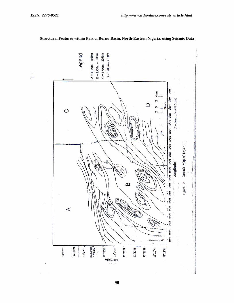
Figure 9 depicts isopach map of layer II. This map exhibits thickness variation of 650 to 1010m. The northeastern, southeastern and south central regions have sediment thickness values ranging from 790 to 1010m, 810 to 970m and 830 to 890m respectively, as compared to the northwestern part which has thickness value between 650 and 810m. A gentle slope feature characterized this map. The southeastern region is likely an area for drilling hydrocarbon wells. Isopach map of layer III as shown in figure 10 shows sediment thickness ranging from 1100 to 2100m. The northwestern and southeastern regions show sediment thickness of 1100 to 1600m and 1900 to 2100m respectively, Also, the northeastern and south central regions show high sediment thickness ranging from 1700 to 2050m and 1550 to 1800m respectively, krumta-1 and Gaibu -1 wells are located at the last two regions. This map shows more closures than the previous maps with most of them coinciding with zones of thick sediments. CONCLUSION The two-way travel time (TWT) for most of the seismic lines for the horizons range from 190 to 1800milliseconds. The depth of all the layers from ground level ranged between 100 to 2050m. Isochron and depth maps were drawn for the horizons and faults were distinctly seen. The lower part depicts fold structure that are not well developed. Again, the isopach map was drawn for three layers. The thickness of sediments ranged from 100 to 2100m. Moreso, this high sediment thickness of 100 to 2100m show that the basin has some hydrocarbon potentials. The quantity of available exproable hydrocarbon deposit is low and so far uneconomical and this must be due to other factors that have also not been conclusively defined in most of the research work in Bornu Basin. We at this juncture therefore recommend that since this study is capital intensive, government should sponsor researches into detailed study of the basin; so that continuous basinal analysis and fine tuning of the seismic data processing and interpretation techniques which will help to enhance seismic data resolution, data quality and possible detection of better productive oil and gas reservoirs. REFERENCES Adepelumi, A. A. Falebita, D.E, Olurunfemi, A.O.Olalayoriju, S. I. (2010). Source-rock Investigation of the
Turonian –Maastrichtian Fika Shale from Wireline-logs, Chad Basin, Nigria. International Journal of Petroleum science and technology 4(1): 19-42.
Ajakaiye, D.E. and Ajayi, C.I (1981). Geophysical Investigation in the Benue Trough –A Review. Earth
Exploration society. 5 (2): 110-125. Ananaba, S.E. and Ajakaiye (1983). A Correlation between Lanset Lineaments and Regional Gravity
Anomaly Trends over the Chad Basin in Nigeria. Nigerian Journal of mining and Geology. 20(1): 216.
Avbovbo, A. A. Ayoola, E.O, Osahon, S.A. (1986). Depositional and Structural Styles in Chad Basin of
Northwestern Nigeria, American Association of petroleum Geologist Bulletin. 78(8): 1405-1434. Carter, J.D. Barbar, W; Jan, E.A; Jones, G.A (1963). The Geology of parts of Adamawa, Bauchi and Bornu
Provinces in Northeastern Nigeria. Geological Survey Bulletin. 30 (4):106 – 108 Dobrin, M.D. and Savit, C.H. (1988). Introduction to Geophysical Prospecting. New York. Mc Graw Hill
Book Company Grant, F.S. and West, G.F. (1965). International theory in Applied Geophysics. New york. Mc Graw hill. Kofron, B.M., Jenkinson, J.T., Maxwell, G.S., Onyeise, B.A., Febdanil, F.N. (1996). Reservoir Description
and Future plans for Unam oil Field OML 67 Nigeria. Nigerian Association of petroleum Exploiationists Bulletin. 11(2): 22-25.
ISSN: 2276-8521 http://www.irdionline.com/catr_article.html
89
Mathais, G. (1976). Short Review of the Geology of the Chad Basin in Nigeria. Ibadan, University of Ibadan Press.
International Journal of Research and Advancement in Physical Science, Volume 3, Number 2, 2013 Milsom, J. (2003). Field Geophysics. John Wiley and Sons Ltd, England Okosun, E.A.(1995). Review of the Geology of Bornu Basin. Journal of Mining and Geology. 31(2) : 112-
113. Peters, S.W (1981). Stratigraphy of Chad and Lullemenden Basins. West Africa. Ecologae Geology.
Helvertiae. 74 (23): 139-159. Peters, S. W. and Ekweozor, C. M. (1982). Petroleum Geolog of Benue Trough and Southeastern Chad
Basin, Nigeris. American Association of Petroluem Geologists Bulletin. 66 (8): 1141-1149. Tearpock, D. and Bischike, R. E (1991). Applied Subsurface Geological Mapping. New York, Prentic Hall. Telford, W. M; Keys, D. A; Geldart, L. P. and Sherrif R. E. (1976). Applied Geophysics. New York,
Cambridge University Press. Wikipedia (2011). The Free Encyclopedia. ASCN/2013/952/E. E Otu/Email:[email protected]/22/07/2013/FRIB
ISSN: 2276-8521 http://www.irdionline.com/catr_article.html
90
Structural Features within Part of Bornu Basin, North-Eastern Nigeria, using Seismic Data
ISSN: 2276-8521 http://www.irdionline.com/catr_article.html
91
International Journal of Research and Advancement in Physical Science, Volume 3, Number 2, 2013
ISSN: 2276-8521 http://www.irdionline.com/catr_article.html
92
Structural Features within Part of Bornu Basin, North-Eastern Nigeria, using Seismic Data

ISSN: 2276-8521 http://www.irdionline.com/catr_article.html
93
International Journal of Research and Advancement in Physical Science, Volume 3, Number 2, 2013

ISSN: 2276-8521 http://www.irdionline.com/catr_article.html
94
Structural Features within Part of Bornu Basin, North-Eastern Nigeria, using Seismic Data
ISSN: 2276-8521 http://www.irdionline.com/catr_article.html
95
International Journal of Research and Advancement in Physical Science, Volume 3, Number 2, 2013

ISSN: 2276-8521 http://www.irdionline.com/catr_article.html
96
Structural Features within Part of Bornu Basin, North-Eastern Nigeria, using Seismic Data
ISSN: 2276-8521 http://www.irdionline.com/catr_article.html
97
International Journal of Research and Advancement in Physical Science, Volume 3, Number 2, 2013
ISSN: 2276-8521 http://www.irdionline.com/catr_article.html
98
Structural Features within Part of Bornu Basin, North-Eastern Nigeria, using Seismic Data