abn 96 095 684 389 asx limited asx : fnt company ... · prospective portfolio of porphyry copper-...
TRANSCRIPT

ADDRESS PHONE EMAIL PO Box +61 (08) 9295 0388 [email protected] West Perth FAX WEBSITE WA 6872 Australia +61 (08) 9295 3480 www.frontierresources.com.au
ABN 96 095 684 389
ASX Limited ASX : FNT
Company Announcements Office 31st October 2012
Technical Report – Quarter Ended 30th September 2012
Frontier ('the Company') is an innovative and socially responsible junior mineral explorer focussed on a highly prospective portfolio of porphyry copper- gold -molybdenum, porphyry gold, mesothermal and epithermal gold hosting Exploration Licences in Papua New Guinea (Figure 1).
TORQUE MINING LTD Frontier's majority owned public subsidiary Torque Mining Ltd, is exploring a suite of highly prospective projects in Tasmania , Australia for gold and base metals and will probably undertake an Initial Public Offering in early 2013.
Torque announced a Joint Venture with BCD Resources Ltd on 9/10/12, whereby the Stormont gold-bismuth Indicated Resource in northern Tasmania is proposed to be mined and processed through BCD's Beaconsfield Mill.
The proposed mining and processing is subject to completion of a favourable Feasibility Study and granting of a Mining Lease, but could provide Torque with significant cash flow in early - mid 2014.
SUDEST PROJECT - 100% FRONTIER EL 1594 (Figures 1 and 2) has gold in drainage anomalies over a 45 kilometre strike length along the western 2/3 of the island. Frontier are pursuing the attractive high grade gold exploration targets demonstrated in trenches, plus variably altered intrusives with compositions commonly associated with mineralised porphyry systems.
Assay results from the 2,825 soil samples collected midyear on the Adelaide and Feiori grids have now been received, are being plotted / evaluated and will be reported forthwith.
Figure 1

2
31 trench samples were reported and best results from east to west at the Adelaide Prospect included true widths across the strike of the vein of 2m of 21.71 g/t gold, 2m of 39.85 g/t gold, 2m of 22.34 g/t gold and 2m of 2.74 g/t gold. The peak assay grade was 62.8 g/t gold.
The 8 Cornucopia trench samples returned a maximum of 1m grading 11.4 g/t gold The associated 6m interval had a weighted assay average of 3.72 g/t gold. This zone of gold mineralisation is located about 300m NW of the historic Cornucopia mine and could represent a repetition of it.
The remaining 120 trench sample assays are expected to be returned imminently and announced. Laboratory turnaround time has been atrocious due to upgrading of their facilities.
NEWCREST MINING LTD EARN-IN JOINT VENTURE The Newcrest Mining Ltd Earn-In Joint Venture was active at both Andewa and Schrader during the Quarter.
EL 1345 and EL 1951 are located near the north coast of western New Britain Island and are highly prospective for porphyry gold-copper and epithermal gold deposits.
Diamond core drilling recommenced at Andewa in early July and holes ADH014, ADH 015, ADH016 and ADH017 have all been completed.
The last hole budgeted by the Frontier/Newcrest Earn-In Joint Venture for this financial year is ADH018 and it was abandoned 28/10 at 226.2m depth.
An aeromagnetic and radiometric geophysical survey was completed over the Mt Schrader crater and surrounding high external slopes. Data has been received and is being interpreted.
OK TEDI MINING LTD JOINT VENTURES The Ok Tedi Mining Ltd (OTML) Joint Ventures on 5 of Frontier’s Exploration Licences are moving ahead systematically.
EL 1351 - Likuruanga is highly prospective for porphyry copper, high-grade gold - silver -zinc skarn and /or epithermal gold deposits. The area contains the Esis porphyry occurrence and the Bukuam porphyry related copper, molybdenum, gold and zinc soil anomalies.
The Esis drilling program concluded in September with the completion of NBE014 and NBE015. Fifteen diamond drillholes have been completed to date for a total of 7,590.90m.
Multiple zones of copper mineralisation have been shown to extend over a +1,100m strike length in drill holes (Frontier/OTML JV plus shallow historic drilling) and the mineralisation is open in all directions (along strike N and S, across the width from E to W and at depth).
Porphyry copper mineralisation was been demonstrated by Frontier /OTML over a +750m strike length between mineralised intercepts in drill holes NBE002 and 006 and drill results include:
NBE001 - 238m grading 0.37% copper (from 3m to 241m). NBE002 - 184m grading 0.30% copper (from 2m to 186m). NBE003 - 199m grading 0.28% copper( from 0m to 199m
Figure 2
Figure 3

3
NBE004 -274.2m grading 0.25% copper (from 4m to 278.2m) +18m grading 0.30% copper (from 691m to 709m)
NBE005 - 306.8m grading 0.28% copper (from 18m to 324.8m). NBE006 - 232.5m grading 0.27% copper (from 3.5m to 236.0m) NBE007 -138.0m grading 0.23% copper (from 0m to 138m) + 233.8m grading 0.20% copper
(from 368.9m to 602.7m EOH)
The copper mineralisation is open at depth (+700m vertically below surface) in multiple zones. NBE001 was terminated in 0.41% copper at 697.6m (drilled vertically). NBE007 was terminated with 233.8m grading 0.20% copper to 602.7m, also showing
mineralisation to the west of the long section line (60 degree inclination).
The assay results indicate that the mineralisation is open to the east. NBE004 was terminated in 0.38% copper at 719.9m (60 degree inclination). NBE005 was terminated in 0.21% copper at 598.5m (60 degree inclination). NBE006 was terminated in 14.3m grading 0.23% copper at 598.3m (60 degree inclination) with
elevated molybdenum mineralisation. A 215m wide copper mineralised zone was intersected in NBE014 (from 40m to end of hole at 255m -
terminated prematurely due to drilling issues) and a 402m wide copper mineralised zone was intersected in NBE015 (from surface).
These latest holes indicate continuity of mineralisation at depth and laterally from their locations.
Signatures of porphyry style alteration and mineralisation are present and evidence of a porphyry system at depth. The presence of mineralised breccias in NBE015 suggests those 'structures' are possible conduits tapping into a larger mineralising porphyry system at depth
Further drilling was recommended.
EL 1595 - Bulago is located in PNG between the OK-Tedi porphyry copper-gold and the Porgera gold Deposits. Targets are very high-grade epithermal and skarn gold, bulk mineable intrusive related gold deposits and porphyry copper-gold deposits. The Suguma and Funutu Prospects have at least 10 locations with high-grade gold in outcrop channel samples with multiple orientations of mineralisation.
Nine drill holes have been completed by OTML at Bulago for 3,302.9m, including 2 holes at the Suguma high-grade gold Prospect.
Assay results for holes BUL002 - BUL006 are reported herein and results for BUL007, SUG001 and SUG002 are yet to be returned.
Each of the holes returned one or more intercepts of mineralisation with greater than 1.0 g/t gold and hole BUL002 demonstrated 63.2m grading 0.12% copper + 0.10 g/t gold. Peak results included 5.9m of 1.71 g/t gold in hole BUL003, with up to 0.22% copper, 17.4 g/t silver and 118 ppm molybdenum.
EL 1597 - Leonard Schultz is located in NW Papua New Guinea approximately 65km to the east along the same structural zone that hosts the massive Freida River porphyry copper-gold deposits. The EL is highly prospective for porphyry copper-gold and quartz sulphide vein gold deposits.
A reconnaissance geological mapping program was initiated with good progress over the large broad copper anomalous area, focussing along drainages and along ridges and soil lines.
Three areas of stronger copper anomalism were prioritised for more detailed examination. Targets A, B & C are based on a combination of OTML soil copper responses and observed mineralisation and alteration in outcrop and float.
EL 1592 - East New Britain covers much of the Gazelle Peninsula in East New Britain. Targets are high-grade epithermal and skarn gold, bulk mineable intrusive related gold and porphyry copper-gold deposits
No field work was conducted during the quarter.
EL 1598 - Central New Britain covers about 693 sq km near the northern coast of the Island of New Britain. Targets are porphyry copper, higher-grade zinc skarns and /or epithermal gold deposits.
No field work was conducted during the quarter, however the aeromagnetic and radiometric data was received and is being interpreted.

4
DETAILS Figure 1 shows the locations of Frontier’s Exploration Licences in Papua New Guinea.
SUDEST - EL 1594 Field crews completed a 2.5 month 'maiden' exploration program on the Sudest EL in Milne Bay, eastern Papua New Guinea (Figures 1 and 2) in mid 2012, consisting of 2 grid based soil sampling programs (covering a total of about 5 sq km) and hand trenching at 2 prospects.
The 2,825 assay results will provide first class vectors to mineralisation and define excellent future trenching and drilling targets. 1,474 grid based soil samples were collected from the 3.2km x 1.0 km Adelaide – Cornucopia soil grid (Figure 4) and 1,200 soil samples were collected from the 2.0km x ~1.2km Feiori soil grid (Figure 4).
114 trench samples were collected from new and re-excavated historic hand trenches at the Adelaide Prospect, plus 1 creek outcrop grab sample and 36 trench samples were collected from the Cornucopia Prospect.
Assays were returned for 24 x 1m long, initial trench channel samples from the Adelaide Prospect and 8 x 1m long samples from the Cornucopia Prospect. Additional trench results are still awaited . Final gold assays have recently been received for the soils and are being collated and released when possible.
Three historic hand cut trenches were deepened at Adelaide and an additional trench was cut over a 12m strike length to confirm the continuity, width and tenor of the higher grade section of the E-W trending gold mineralised zone.
A previous explorer sampled locally along strike of this vein returning 2m of 104 g/t gold and Frontier noted it contained fine grained traces of visible gold within vugs
Best Frontier results from east to west in this sector included true widths across the strike of the vein of 2m of 21.71 g/t gold, 2m of 39.85 g/t gold, 2m of 22.34 g/t gold and 2m of 2.74 g/t gold. The peak assay grade was 62.8 g/t gold. Refer to Table 1 for weighted assay averages and Table 2 for all assay results
Seven additional historic trenches were re-sampled over a 45m total strike length (including the above) with results such as 1m of 0.46 g/t gold. Refer to Figure 2 for the location and results of the historic trenching
Table 1.
Figure 4

5
Sample
Number
Trench
Number
Length
(m)Au1 Au2 Au3 Au4
Au
Average
124001 AT10A 1m 27.20 24.80 62.80 33.10 36.98124002 1m 6.51 6.92 9.67 7.70
124003 1m 0.03 0.02 0.02
124004 1m 0.00 0.00
124005 1m 0.00 0.00
124006 AT9A 1m 0.06 0.05 0.05
124007 1m 54.20 56.90 36.70 49.27124008 1m 32.50 36.10 22.70 30.43124009 AT9A 1m 0.01 0.03 0.02
124010 1m 2.92 3.57 3.25
124011 AT11A 2m 2.00 2.46 2.23
124012 AT11B 1m 0.45 0.62 0.45 0.21 0.43
124013 1m 0.13 0.09 0.04 0.09 0.09
124014 AT11C 1m 0.96 0.84 1.22 1.01
124015 1m 0.00 0.00
124016 1m 0.28 0.28
124017 AT012B 1m 0.24 0.18 0.21
124018 AT8C 1m 7.24 7.01 4.61 6.29
124019 1m 32.80 36.70 41.90 37.13124020 AT7A 1m 0.48 0.60 0.31 0.46
124021 1m 0.19 0.16 0.17
124022 AT6B 1m 0.12 0.12
124023 1m 1.01 1.01
125001 CT1A 1m 0.00 0.01 0.00
125002 1m 4.11 4.66 8.09 5.62125003 1m 0.48 0.42 0.35 0.42
125004 1m 0.29 0.22 0.42 0.31
125005 1m 2.70 2.74 2.01 2.48
125006 1m 2.00 2.11 1.85 2.49 2.11
125007 1m 11.40 11.40125008 1m 0.03 0.03
Sudest initial trench assays This higher grade zone of mineralisation is located about 400m along strike to the west of the historic Adelaide mine.
The close spaced trenches showed that the mineralisation has a relatively consistent width and grade, but is mildly disrupted by dextral faulting.
The 8 Cornucopia trench samples returned a maximum of 1m grading 11.4 g/t gold The associated 6m interval had a weighted assay average of 3.72 g/t gold. This zone of gold mineralisation is located about 300m NW of the historic Cornucopia mine and could represent a repetition of it.
Refer to the ASX release dated 16th April and 3rd of May 2012 for details relating to the Sudest Gold Project.
ANDEWA PROJECT (EL 1345 and EL 1951) The Andewa Project is subject to a Farm-In Agreement with Newcrest Mining Ltd (Figure 3).
Newcrest can earn 60% equity in the project by sole funding A$19.25 million of exploration expenditure for the project within 4 years.
After Earn-In, Frontier may elect to be deferred carried to completion of a Feasibility Study, repayable from 50% of mine profit.
After Earn-in, Newcrest may acquire an additional 12% equity in the project prior to the 'Decision to Mine' for a formula based payment relating to the feasibility study's estimated reserves and resources.
Frontier are currently operators but Newcrest can elect to become operator.
Five drill holes are proposed for the 2012 Financial year 5,000m total drilling program. ADH014 was completed at 1,004.0m on 15/8/12.
ADH015 was terminated at 847.8m on 15/8/12.
ADH016 was terminated at 925.8m on 3/10/12
ADH017 was completed at 1,000.4m on 3/10/12.
ADH018 was abandoned at 226.2m on 28/10/12.
Eighteen holes have been completed since the program commenced mid-2011, for a total of 9,892.9m, of which 4,632.4m was part of the Newcrest Joint Venture program (commencing 1/1/2012).
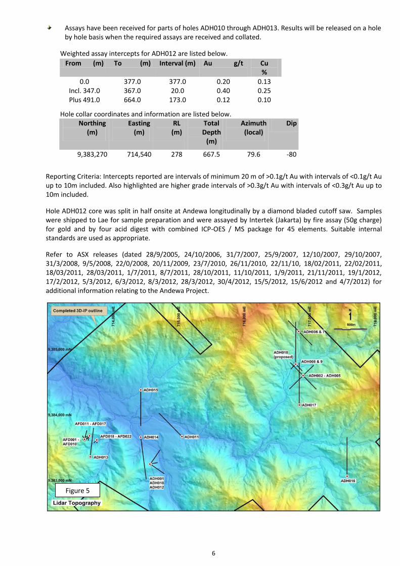
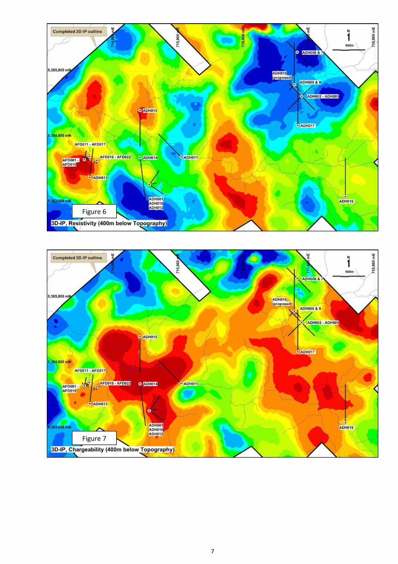
Five plans are attached as Figures 5 -9 showing the location of all drilling to date on Lidar topography, 3D-IP resistivity at 400m below topography, 3D-IP chargeability at 400m below topography, magnetics reduced to the pole and 1st derivative of the RPT, respectively.
Geological summaries and core photographs of ADH014 and 015 are attached.
Table 1
Figure 4
6
Assays have been received for parts of holes ADH010 through ADH013. Results will be released on a hole by hole basis when the required assays are received and collated.
Weighted assay intercepts for ADH012 are listed below.
Hole collar coordinates and information are listed below.
Northing (m)
Easting (m)
RL (m)
Total Depth
(m)
Azimuth (local)
Dip
9,383,270 714,540 278 667.5 79.6 -80
Reporting Criteria: Intercepts reported are intervals of minimum 20 m of >0.1g/t Au with intervals of <0.1g/t Au up to 10m included. Also highlighted are higher grade intervals of >0.3g/t Au with intervals of <0.3g/t Au up to 10m included.
Hole ADH012 core was split in half onsite at Andewa longitudinally by a diamond bladed cutoff saw. Samples were shipped to Lae for sample preparation and were assayed by Intertek (Jakarta) by fire assay (50g charge) for gold and by four acid digest with combined ICP-OES / MS package for 45 elements. Suitable internal standards are used as appropriate.
Refer to ASX releases (dated 28/9/2005, 24/10/2006, 31/7/2007, 25/9/2007, 12/10/2007, 29/10/2007, 31/3/2008, 9/5/2008, 22/0/2008, 20/11/2009, 23/7/2010, 26/11/2010, 22/11/10, 18/02/2011, 22/02/2011, 18/03/2011, 28/03/2011, 1/7/2011, 8/7/2011, 28/10/2011, 11/10/2011, 1/9/2011, 21/11/2011, 19/1/2012, 17/2/2012, 5/3/2012, 6/3/2012, 8/3/2012, 28/3/2012, 30/4/2012, 15/5/2012, 15/6/2012 and 4/7/2012) for additional information relating to the Andewa Project.
From (m) To (m) Interval (m) Au g/t Cu %
0.0 377.0 377.0 0.20 0.13 Incl. 347.0 367.0 20.0 0.40 0.25 Plus 491.0 664.0 173.0 0.12 0.10
Figure 5
7
Figure 6
Figure 7

8
Figure 8
Figure 9

9
ANDEWA DRILL HOLE LITHOLOGIC SUMMARIES AND CORE PHOTOGRAPHS. Note that any percentages are strictly estimates and may not be well constrained. This data is to give the reader an idea of what was observed in the hole. Photos are selective and not necessarily representative. ADHO14. Drill hole ADH014 encountered a thin layer of boulder terrace at the surface and drilled straight into a diorite unit. Down to a depth of 150m, the hole encountered an extensively brecciated and silicified unit. The breccia displays monomictic to polymictic textures with clasts of diorite only and clasts of diorite and andesite respectively. The diorite clasts are strongly bleached and moderately altered to clay while the andesite clasts a fresh with chlorite +-epidote +- trace pyrites. Most of the clasts are angular and rotated with open spaces partially filled with pyrites. Late stage of pyrite + sericite veinlets cuts through with fine hairline magnetite veins. The weak to moderate pyrite mineralisation on the class may be related to the late phyllic alteration which is overprinted by weak clay alterations.
40.9 – 46.9m: Quartz Andesite Breccia unit – crackled, strongly silicified and argillic altered enriched w/white puggy clay material.
Polymictic breccia (40m-150m) This breccia unit appears to be at the top part of an intensely shattered and variably brecciated rock sequence which continues from 150m to half way down the hole. The predominant rock-type within this sequence is a

10
diorite unit (and microdiorite) with some occasional quartz diorite. Small dykes of andesite/basaltic units intrude the above unit. The shearing and shattered event in the breccia is perhaps related to this intrusive activity.
Basaltic dyke intruding older bleached andesites rocks at 211.00m – 212.30m
Brecciated bleached rock with late qz-py-sulph [email protected] – 463.30m
Polymictic breccia bands within this unit range from a couple of meters to up to ten meters thick. The rocks appear to have been subjected to strong pervasive silicification with strong qz-ser-py alteration with weak to moderate clay enrichment in the fractures. The silicification appears to have been overprinted by a bleaching event, possibly related to the late andesite and diorite intrusive stages which appear to have given it the vuggy appearance. Some milky white qz-cb? pyrite veining cuts the above units, pyrite is ubiquitous and constitutes up to 3% of the rock.
From halfway down the hole to the end at 1004 m, the down hole geology is dominated by mafic rich rocks. Pyroxene andesite appears to be the dominant host rock, intruded in places by diorites/microdiorite.
Host rock Pyroxene Andesite, variably brecciated with sheeted qz-carbonate veins @670-670.30m
11
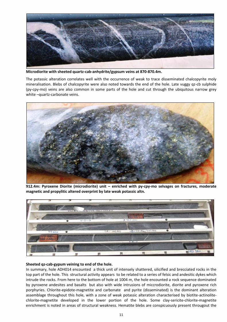
Microdiorite with sheeted quartz-cab-anhydrite/gypsum veins at 870-870.4m.
The potassic alteration correlates well with the occurrence of weak to trace disseminated chalcopyrite moly mineralisation. Blebs of chalcopyrite were also noted towards the end of the hole. Late vuggy qz-cb sulphide (py-cpy-mo) veins are also common in some parts of the hole and cut through the ubiquitous narrow grey white –quartz-carbonate veins.
912.4m: Pyroxene Diorite (microdiorite) unit – enriched with py-cpy-mo selvages on fractures, moderate magnetic and propylitic altered overprint by late weak potassic altn.
Sheeted qz-cab-gypum veining to end of the hole. In summary, hole ADH014 encounted a thick unit of intensely shattered, silicified and brecciated rocks in the top part of the hole. This structural activity appears to be related to a series of felsic and andesitic dykes which intrude the rocks. From here to the bottom of hole at 1004 m, the hole encounted a rock sequence dominated by pyroxene andesites and basalts but also with wide intrusions of miccrodiorite, diorite and pyroxene rich porphyries. Chlorite-epidote-magnetite and carbonate and pyrite (disseminated) is the dominant alteration assemblage throughout this hole, with a zone of weak potassic alteration characterised by biotite-actinolite-chlorite-magnetite developed in the lower portion of the hole. Some clay-sericite-chlorite-magnetite enrichment is noted in areas of structural weakness. Hematite blebs are conspicuously present througout the

12
hole in less silicified rocks.. Rimmed quartz-carbonate and pyrite veining is ubiquitous and occurs across all lithlogical boundaries. Pyrite, chalcopyrite and molybdenite are the main sulphide minerals present, with pyrite normally occuring as blebs and veins especially within vugghy quartz sulphide veins which are normally sub parallel to core axis. Trace disseminated chalcopyrite-molybdenite mineralisation is associated with the potassic phase. ADH 015 From surface to 300m, hole ADH015 drilled through a pyroxene rich andesitic sequence which was intruded by occasional felsic and mafic dykes. The dykes consisted principally of fine grained equigranular rocks mainly of dioritic and or dacitic composition. They appear to occur within a couple of clay shear zones which were tens of meters thick. Abundant clay-sericite-pyrite-fuchsite development is common within these shear zones. Silicified and brecciated rock fragments containing visible chalcopyrite-molybdenite mineralisation were sampled within these shear or fracture zones. The chalcopyrite-molybdenite occurs as blebs in veins and in mineralised clasts within these brecciated fragments. The dykes are usually light green in colour due to the pervasive epidote alteration throughout this unit.
Chalcopyrite-molybdenite blebs on vein in brecciated clasts within the shear zone. From 300 m to 700 m the hole encountered a sequence of pyroxene rich andesites with alternating narrow bands of fine grained pyroxene basalts. The rocks appear to have been intruded by wide dykes of microdiorite which are relatively fresh and unaltered compared to the andesitic host. Fine disseminated magnetite is common and moderately pervasive throughout with haematitic (reddish) alteration.
Weakly mineralised and altered microdiorite at 598-600m

13
Abunadant hematite blebs in a brecciated pyroxene andesite unit at 432.20m – 432.40m Chlorite + epidote +-pyrite alteration is moderate throughout. Veining is weak to moderately selective throughout with pyrite + quartz +- calcite. Thick quartz-carbonate –sulphide veining is common throughout the pyroxenes andesite unit and veins are usually parallel or sub parallel to core axis.
Quartz-calcite-sulphide vein sunb parallel to core axis at 458m.
This event may be related to the weakly mineralised microdiorite intrusives. Narrow grey white quartz-carbonate veining is quite common within both the pyroxene andesites and the microdiorite suggesting this event postdates the microdiorite intrusive activity. They sometimes form a halo around pyrite veins also suggesting that a pyrite phase may postdate the quartz-carbonate stage.
Pyrite is the main mineralisation mineral throughout and is confined to veins and structures (minor faults) exploiting the pre-existing fractures. Trace moly is associated with pyrite + quartz + sericite vein and confined in the centre of the vein bounded by quartz and pyrite. Also moly presence is noted in moderately sheared and clay altered fractures.
Pyrite-chalcopyrite-molybdenite blebs in Quartz-ccarbonate-sulphide vein at 460m. The last 200m of this hole to 850m is dominated by a sequence pyroxene andesites and basalts with lesser microdiorites. These rocks have been subjected moderately pervasive chlorite-epidote-carbonate-magnetite alteration with abundant narrow quartz-carbonate stockworking.Weak to trace chalcopyrite mineralisation is

14
noted towards the end of the hole as blebs usually in quartz-cab-sulph veins.These veins are generally parallel to core axis.
Quartz-sulphide vein at 731.0m
Alternating basaltic and andesite units from 825m – 829m with sheeted quartz –carbonate veining. In summary, weak to trace chalcopyrite-molybdenite mineralisation is observed in most parts of this hole especially from 200-500m and thence from 700m down to the end of the hole. It usually occurs as blebs, associated with quartz sulphide veins and in fragments within clay-sericite-pyrite enriched shear or fracture zones. The middle part of this hole is dominated by relatively fresh weakly mineralised microdiorites. The dominant alteration assemblage throughout the hole is propylitic (epidote-chlorite-magnetite-carbonate and pyrite).
15
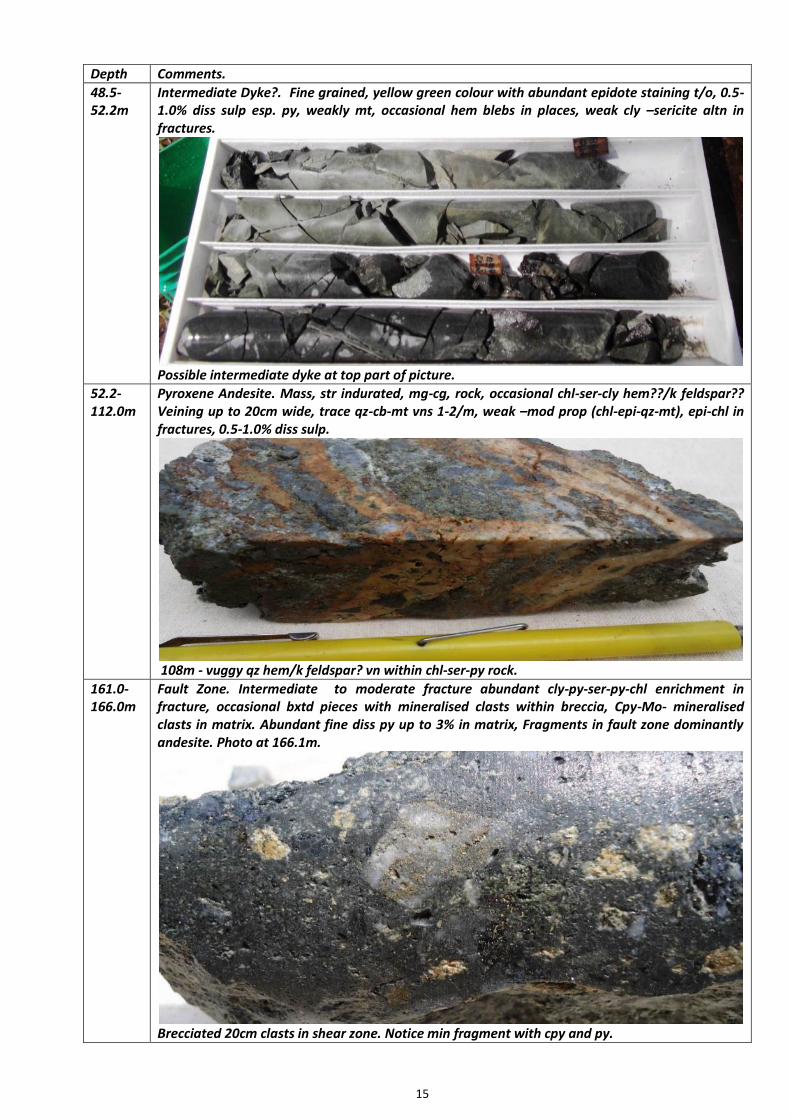
Depth Comments.
48.5-52.2m
Intermediate Dyke?. Fine grained, yellow green colour with abundant epidote staining t/o, 0.5-1.0% diss sulp esp. py, weakly mt, occasional hem blebs in places, weak cly –sericite altn in fractures.
Possible intermediate dyke at top part of picture.
52.2-112.0m
Pyroxene Andesite. Mass, str indurated, mg-cg, rock, occasional chl-ser-cly hem??/k feldspar?? Veining up to 20cm wide, trace qz-cb-mt vns 1-2/m, weak –mod prop (chl-epi-qz-mt), epi-chl in fractures, 0.5-1.0% diss sulp.
108m - vuggy qz hem/k feldspar? vn within chl-ser-py rock.
161.0-166.0m
Fault Zone. Intermediate to moderate fracture abundant cly-py-ser-py-chl enrichment in fracture, occasional bxtd pieces with mineralised clasts within breccia, Cpy-Mo- mineralised clasts in matrix. Abundant fine diss py up to 3% in matrix, Fragments in fault zone dominantly andesite. Photo at 166.1m.
Brecciated 20cm clasts in shear zone. Notice min fragment with cpy and py.
16
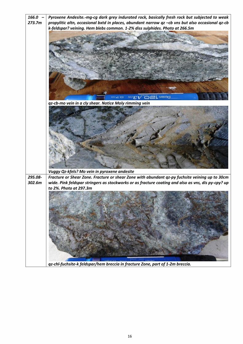
166.0 – 273.7m
Pyroxene Andesite.-mg-cg dark grey indurated rock, basically fresh rock but subjected to weak propylitic altn, occasional bxtd in places, abundant narrow qz –cb vns but also occasional qz-cb k-feldspar? veining. Hem blebs common. 1-2% diss sulphides. Photo at 266.5m
qz-cb-mo vein in a cly shear. Notice Moly rimming vein
Vuggy Qz-kfels? Mo vein in pyroxene andesite
295.08-302.6m
Fracture or Shear Zone. Fracture or shear Zone with abundant qz-py fuchsite veining up to 30cm wide. Pink feldspar stringers as stockworks or as fracture coating and also as vns, dis py-cpy? up to 2%. Photo at 297.3m
qz-chl-fuchsite-k feldspar/hem breccia in fracture Zone, part of 1-2m breccia.

17
304.0-450.4m
Microdiorite-compact equigranular rock, mg-cg, occasional hem and mt blebs t/o, weak –mod chl-epi-cb-mt alteration, occasional clay-chl-ser enrichment in fractures up to 10cm,or coating in fractures and as stringers, occasional qz-cab-mo sulphide vns up to 10cm. (Basaltic dyke from 421-423m)
vuggy qz-py-cpy –mo vein at 381.1m
Host rock microdiorite from 430-433.0m
463.0-535.5m
Andesite. Possibly microdiorite, medium grained equigranular with occasional 1-2m basaltic dykes. Generally weakly mineralised but with occasional qz-chl-epi-cab veins up to 1-2/m, up 1% total sulphides but locally more. Occasional narrow vuggy qz-py-cpy-mo veins // to core axis.
520m - qz-cb-sph--cpy-py-Mo vein, part of 0.60m long vein.

18
598.5-675.3m
Microdiorite. Medium grained equigranular roc. Relatively fresh weakly mineralised and altered. Occasional grey white qz-cab veins/stringers quite common, trace py up 0.5%. Hem blebs common in places.
675.3-691.1m
Pyroxene Basalt. Fine to medium grained, competent rock with occasional narrow microdiorite bands, variably silicified with moderate to weak propylitic alteration, some individual pyroxene grains altered to epidote, Epidote common as vns and blebs, mod magnetic as blebs in rock and in veins, trace chalcopyrite mineralisation as diss and blebs in places. From 685.70-690.0m zone of intense-str-mt-qz-gyp ±k feldspar stockwork, milky white qz-cb-gyp vnlts x-cut early .
689.1m. Milky white qz-cb-gyp? Vein crosscut earlier veining.
801.0-846.3m
Andesite/Basalt. Interval with alternating basalt and andesite units, also subjected to moderate propylitic alteration dominated by epi-chl-and mt, abundant narrow qz-cb-gyp vns/stringers, 1-2/m, trace blebs of cpy and mo down to this depth, rock variably silic and bxtd with up to 3% total sulphide.

19
MT SCHRADER A 3,851 line kilometre aeromagnetic and radiometrics geophysical program, that covered the crater area of the Mt Schrader Exploration Licence was completed in late July. The survey was flown on a 100m line spacing and the geophysical data will be modelled to provide vectoring towards possible mineralised zones. The data has been received and is being interpreted.
OK TEDI MINING LTD JOINT VENTURES In May 2010 Frontier and OTML established 2 Joint Ventures that relate to 3 ELs and 2 EL Applications in PNG (that have since been granted) (Figure 1).
OTML have the option to earn 58% of EL 1595 and EL1597 and the option to earn 80.1% of ELs 1351, 1592 and 1598 by spending US$12 million on each EL within 6 years.
Frontier is carried from completion of earn-in to the completion of a Bankable Feasibility Study, with pro-rata (carried) repayments from 50% of its future metal sales.
Frontier’s equity is non-dilutable in ELs 1351, 1592 and 1598 if the PNG government elect to participate in the project at the time of granting of a Mining Lease.
LIKURUANGA - EL 1351 EL 1351 - Likuruanga is prospective for porphyry copper, gold - silver -zinc skarn and /or epithermal gold deposits. The area contains the Esis porphyry occurrence and the Bukuam porphyry related copper, molybdenum, gold and zinc soil anomalies, which are situated about 14km opposite each other on the flanks of the Esis-Sai granitoid complex.
Esis Project The Esis drilling program concluded in September with the completion of NBE014 and NBE015. Fifteen diamond drillholes have been completed to date for a total of 7,590.90m.
A copper mineralised zone about 215m wide was intersected in NBE014 from 40m to end of hole at 255m. The zone is characterised as a pyrite-chalcopyrite-molybdenite-magnetite stockwork.
A 402m wide copper mineralised zone was intersected in NBE015 from surface and hosted primarily in andesite, basalt and siliceous breccias that are intruded by a series of felsic quartz porphyry dykes similar to NBE012. Mineralisation is dominantly pyrite-chalcopyrite and occurs as veins and along fractures in the volcanics whilst it tends to occur as disseminations within chloritised, hornfelsed and phyllic altered matrices of mineralised siliceous breccias. Alteration is dominantly phyllic, characterised by quartz-sericite-chlorite.
Preliminary observations indicate:
Both holes are consistent with previous holes drilled in the area. These holes indicate continuity of mineralisation at depth and laterally further towards the northwest, southeast and southwest. NBE015 has validated the model on the basis that mineralisation also extends towards NBE005.
Signatures of porphyry style alteration and mineralisation are present and evident of a porphyry system at depth.
The presence of mineralised breccias in NBE015 suggests these structures as possible conduits that tap into a larger mineralising porphyry system at depth.
Further drilling is warranted to investigate the depth extent of potassium feldspar-biotite potassic alteration and silicification with associated strong pyrite-chalcopyrite-molybdenite stockwork mineralisation intersected in NBE014.
Multiple zones of copper mineralisation have been shown to extend over a +1,100m strike length in drill holes (Frontier/OTML JV plus shallow historic drilling) and the mineralisation is open in all directions (along strike N and S, across the width from E to W and at depth).
Porphyry copper mineralisation was been demonstrated by Frontier /OTML over a +750m strike length between mineralised intercepts in drill holes NBE002 and 006 (Figures 11 - 17). Drill results include:
238m grading 0.37% copper (from 3m to 241m) in hole NBE001.
184m grading 0.30% copper (from 2m to 186m) in hole NBE002.

20
199m grading 0.28% copper( from 0m to 199m) in hole NBE003.
274.2m of 0.25% copper (from 4m to 278.2m), plus 18m of 0.30% copper from 691m to 709m in NBE004.
306.8m grading 0.28% copper (from 18m to 324.8m) in hole NBE005.
232.5m grading 0.27% copper (from 3.5m to 236.0m) in hole NBE006.
138.0m grading 0.23% copper (from 0m to 138m), plus 233.8m grading 0.20% copper (from 368.9m to 602.7m EOH) in hole NBE007.
The copper mineralisation is open at depth (+700m vertically below surface) in multiple zones. Hole NBE001 was terminated in 0.41% copper at 697.6m (drilled vertically).
Hole NBE007 was terminated with 233.8m grading 0.20% copper to 602.7m, also showing mineralisation to the west of the long section line (60 degree inclination).
The mineralisation is open to the east. Hole NBE004 was terminated in 0.38% copper at 719.9m (60 degree inclination).
Hole NBE005 was terminated in 0.21% copper at 598.5m (60 degree inclination).
Hole NBE006 was terminated in 14.3m grading 0.23% copper at 598.3m (60 degree inclination) with elevated molybdenum (82 ppm compared to the hole average of 25 ppm) suggesting slightly different mineralisation .
Figure 10 is an SRTM topographic image showing the boundary of EL 1351 and the location of the Esis Deposit.
Figure 10 9
Figure 10 9

Refer to the Long Section + Cross Sections (Figures 11 and 12 -16) and drill hole weighted assay tables for information/ results and to visualise the orientation of the copper mineralisation. The location of the drill holes is shown on an oblique Google Earth image looking northerly (NNE) (Figure 18).
Figure 1
Figure 11 9

Figure 12 9
Figure 13 9

23
Figure 2d
Figure 15 9
Figure 16 9
Figure 14 9

Page 24 of 36
Assay results from holes three through seven drilled at the Esis porphyry copper Prospect, EL 1351 - Likuruanga by the Ok Tedi Mining Ltd (OTML) - Frontier Resources Ltd Joint Venture are detailed below. To provide a complete picture of results to date, previously announced holes NBE001 and 002 are also discussed herein.
The long section in Figure 11 shows that the mineralisation in the upper zone is relatively contiguous near surface between all the holes drilled to date. Figures 12 -16 are various cross sections showing the downhole mineralisation. Figure 17 shows drill hole locations at Esis plotted on surface copper geochemistry, with lines showing the location of the long and cross sections. A Google Earth image (Figure 18) shows the location of the various drill holes on an oblique image looking northerly (NNE).
Figure 2
Figure 3
Figure 17 9
Figure 18 9
Page 25 of 36
To
(m)
Intercept
(m)
Copper
(%)
Moly
(ppm)
Entire
Hole0.0 697.6 110.6 0.17 15
0 66.1 66.1 0.27 17
Plus 66.1 228.0 161.9 0.41 57
Plus 228.0 350.0 122.0 0.18 18
Plus 350.0 477.0 127.0 0.26 11
Plus 477.0 537.0 60.0 0.18 7
Plus 537.0 571.0 34.0 0.34 3
Plus 571.0 697.6 126.6 0.16 14
Drill Hole NBE001 Weighted Assay Results
From
(m)
To
(m)
Intercept
(m)
Copper
(%)
Moly
(ppm)
Entire
Hole0.0 716.9 716.90 0.13 14
2.0 186.0 184.0 0.30 19
Incl. 30.1 38.1 8.0 0.40 7
Plus 48.1 54.1 6.0 0.67 3
Plus 74.1 83.6 9.5 0.57 7
Plus 97.6 107.6 10.0 0.37 5
Drill Hole NBE002 Weighted Assay Results
From
(m)
The intercepts of significance are defined herein by a 0.15% copper cut-off, with higher grade zones generally defined by a 0.3% copper cutoff. The results for each hole contain no particularly significant gold mineralisation and as such it is not reported here. The molybdenum is reported so its variation can be noted in context of genetic porphyry copper models, not because it has any particular possible economic value at Esis.
The JV diamond drill holes in varying orientations have achieved a better understanding of the geology with respect to lithology, mineralisation and alteration and will lead to the initial production of a coherent 3D model.
The long section displaying copper in the drill holes demonstrates the consistency of mineralisation between holes and the open nature of the anomaly to the east, south and at depth.
There appears to be at least 3 zones of moderate grade copper mineralisation that are separated by lower grade copper intervals both horizontally and vertically (as seen in the long section and cross sections).
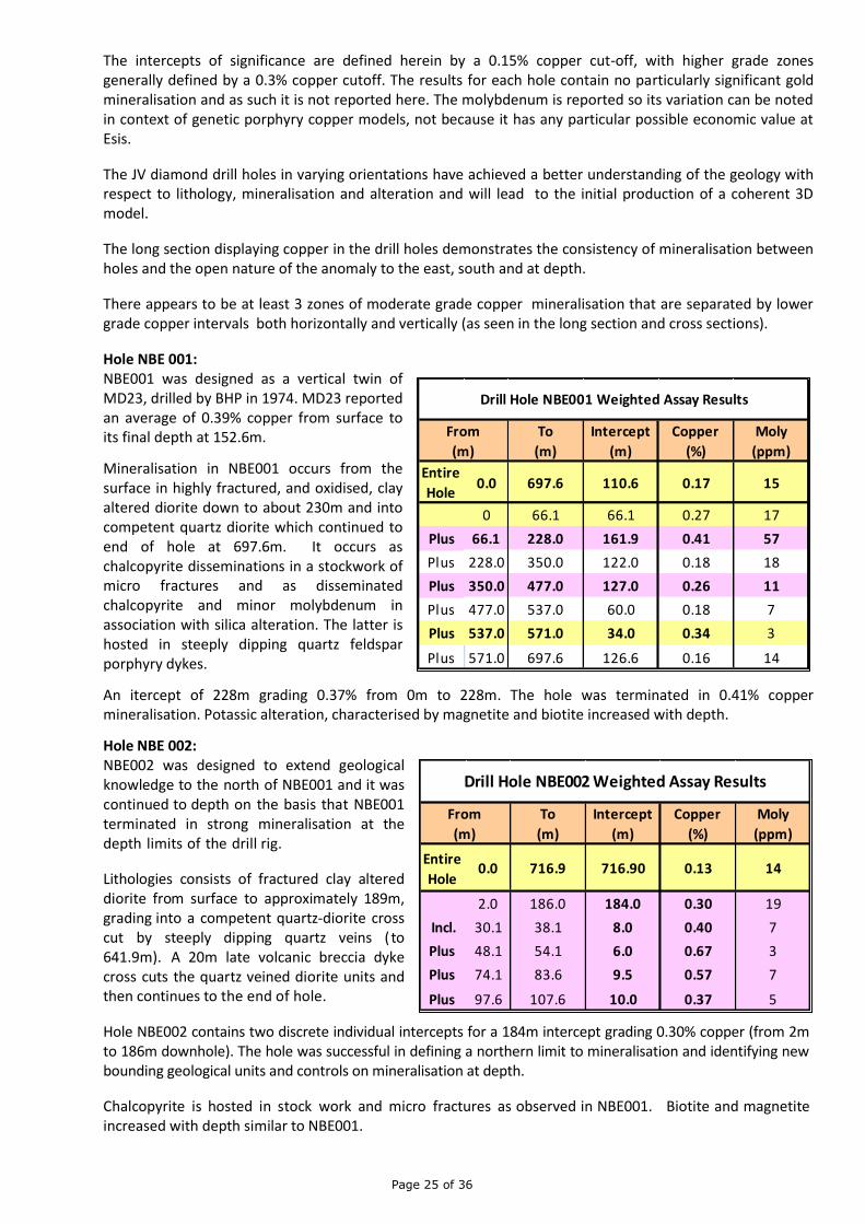
Hole NBE 001: NBE001 was designed as a vertical twin of MD23, drilled by BHP in 1974. MD23 reported an average of 0.39% copper from surface to its final depth at 152.6m.
Mineralisation in NBE001 occurs from the surface in highly fractured, and oxidised, clay altered diorite down to about 230m and into competent quartz diorite which continued to end of hole at 697.6m. It occurs as chalcopyrite disseminations in a stockwork of micro fractures and as disseminated chalcopyrite and minor molybdenum in association with silica alteration. The latter is hosted in steeply dipping quartz feldspar porphyry dykes.
An itercept of 228m grading 0.37% from 0m to 228m. The hole was terminated in 0.41% copper mineralisation. Potassic alteration, characterised by magnetite and biotite increased with depth.
Hole NBE 002:
NBE002 was designed to extend geological knowledge to the north of NBE001 and it was continued to depth on the basis that NBE001 terminated in strong mineralisation at the depth limits of the drill rig.
Lithologies consists of fractured clay altered diorite from surface to approximately 189m, grading into a competent quartz-diorite cross cut by steeply dipping quartz veins ( to 641.9m). A 20m late volcanic breccia dyke cross cuts the quartz veined diorite units and then continues to the end of hole.
Hole NBE002 contains two discrete individual intercepts for a 184m intercept grading 0.30% copper (from 2m to 186m downhole). The hole was successful in defining a northern limit to mineralisation and identifying new bounding geological units and controls on mineralisation at depth.
Chalcopyrite is hosted in stock work and micro fractures as observed in NBE001. Biotite and magnetite increased with depth similar to NBE001.

Page 26 of 36
To
(m)
Intercept
(m)
Copper
(%)
Moly
(ppm)
Entire
Hole0.0 606.8 606.8 0.18 25
0.0 239.0 239.0 0.27 35Plus 239.0 283.0 44.0 0.11 18
Plus 283.0 299.0 16.0 0.22 46Plus 299.0 329.0 30.0 0.11 37
Plus 329.0 421.0 92.0 0.17 15
Plus 421.0 553.0 132.0 0.07 12
Plus 553.0 599.0 46.0 0.12 23
Plus 599.0 606.8 7.8 0.05 15
Drill Hole NBE003 Weighted Assay Results
From
(m)
To
(m)
Intercept
(m)
Copper
(%)
Moly
(ppm)
Entire
Hole0.0 719.9 719.9 0.17 25
0.0 4.0 4.0 0.02 21
Plus 4.0 38.0 34.0 0.24 9
Plus 38.0 48.1 10.1 0.09 17
Plus 48.1 115.5 67.4 0.32 53
Plus 115.5 131.6 16.1 0.06 70
Plus 131.6 278.2 146.6 0.25 63
Plus 278.2 301.0 22.8 0.09 32
Plus 301.0 395.0 94.0 0.20 23
Plus 395.0 453.0 58.0 0.12 2
Plus 453.0 503.0 50.0 0.07 1
Plus 503.0 561.0 58.0 0.10 2
Plus 561.0 669.0 108.0 0.07 2
Plus 669.0 719.9 50.9 0.19 5
Incl. 691.0 709.0 18.0 0.30 6
From
(m)
Drill Hole NBE004 Weighted Assay Results
Hole NBE 003:
NBE003 was designed to cut across NBE001 (crossed at 307m down-hole depth in NBE001), and continued to be drilled to depth for geology and define the northerly extension of the lower mineralised zone of NBE001. It was drilled from the same pad as NBE005 and NBE007.
The geology is consistent down hole with NBE001 & 002 (with the exception of a zone of quartz porphyry in the top of the hole that may extend east).
Lithology consists of fractured clay altered diorite (considered a oxidised cap) from surface to approximately 199m passing through a zone of quartz porphyry (115m to 161m) and into a fine grained mafic diorite, ending short of the quartz diorite found at the end of holes NBE001 /002.
There are two mineralised zones, separated by 10m of internal dilution which together produce a weighted average copper mineralisation intercept at 0.27% copper from 0m to 239m down hole at 0.15% cutoff. Consistent with NBE001, chalcopyrite is hosted in stockwork and micro fractures. However unlike NBE001, no significant quartz-feldspar porphyry dykes were intercepted below 184m.
Hole NBE 004:
NBE004 was designed to test the eastern extension of copper mineralisation intersected in NBE001 and NBE002. Lithologies down hole consist predominantly of variably altered diorite (within oxidised cap to 131.6m) alternating with quartz diorite at depth, which then continues to the end of hole.
Mineralisation is typically chalcopyrite occurring as disseminations in quartz stockwork as well as coating and infilling micro fractures. Discrete zones of mineralisation occur within the upper part, with two zones averaging at 111.5m grading 0.27% copper and 146.6m grading 0.25% copper occurring at 4m and131.6m respectively.
Copper mineralisation is open to the east and at depth with the hole terminated in 0.38% copper (at the limit of the rig’s capacity).
Down hole, the geology is consistent with NBE001 & 2 with the exception of a zone of quartz porphyry zone in the top of the hole that is similar to NBE003. The hole comes into quartz diorite much earlier than found in NBE001 & 2, delineating variation in geology to the north-east.
Hole NBE 005: NBE005 was drilled to test the eastern extent of anomalism from a southern location on the same pad as NBE003 and NBE007.

Page 27 of 36
To
(m)
Intercept
(m)
Copper
(%)
Moly
(ppm)
Entire
Hole0.0 593.5 593.5 0.21 23
0.0 18.0 18.0 0.14 11
Plus 18.0 324.8 306.8 0.28 30
Incl. 36 50 14 0.49 5Plus 324.8 424.0 99.2 0.12 11
Plus 424.0 472.0 48.0 0.20 23Plus 472.0 510.0 38.0 0.09 11
Plus 510.0 524.0 14.0 0.20 20Plus 524.0 540.0 16.0 0.09 28
Plus 540.0 580.0 40.0 0.18 16Plus 580.0 590.0 10.0 0.12 19
Plus 590.0 593.5 3.5 0.23 4
From
(m)
Drill Hole NBE005 Weighted Assay Results
To
(m)
Intercept
(m)
Copper
(%)
Moly
(ppm)
Entire
Hole0.0 598.3 598.3 0.19 25
3.5 236.0 232.5 0.27 21
Incl. 16.0 38.0 22.0 0.35 19
and 86.0 150.0 64.0 0.34 21
Plus 236.0 308.0 72.0 0.07 15
Plus 308.0 528.0 220.0 0.14 25
incl. 356.0 396.0 40.0 0.19 24
Incl. 396.0 446.0 16.0 0.23 49
Plus 528.0 598.3 70.3 0.17 50
Incl. 581.0 592.0 11.0 0.24 117
Drill Hole NBE006 Weighted Assay Results
From
(m)
Down hole, the geology is consistent with NBE001 & 2 being predominantly variably altered diorite. Several zones of mineralisation are present with the main one occurring from 18 – 324.8m averaging at 0.28% copper.
Three other intercepts occur below 306.8m, one being 48m grading 0.20 % copper from 424m down hole.
NBE005 confirmed that the copper anomalism remains open to the east and at depth with the hole producing a intercept of 0.23 % copper over 3.5m from 590m down hole to end of hole.
Although the quartz stockwork appears to be largely unmineralised, it is inferred that a number of phases of quartz veining may be present of which one may be mineralised. Mineralisation appears to be overprinted by phyllic alteration, which in turn, is overprinted by a late stage anhydrite- carbonate-clay-pyrite event.
Being mostly diorite, however, it failed to reach the quartz diorite or pass through the zone of quartz porphyry. The hole stopped early due to drilling conditions.
Hole NBE 006:
This hole was designed to follow up on results from historic hole MD22 that was terminated in 0.27% copper at 152.4m depth vertically.
Hole NBE006 was a scissor drill hole from the historic MD22 pad targeted to investigate the possible extension of the mineralisation to the east, as inferred from historic surface geochemical anomalies coupled with observations made from recent results from drill holes NBE001 and NBE002.
Hole NBE006 is at the lowest RL point of the system in the project drilled to date and notably molybdenum content is increasing.
The collar is located in the southeast and the consistent upper large copper intercepts (the first 200m+ in the holes) deliver a apparent continuous mineralisation length of 630m as by collar distance, and a length of ~760m at ~200m depth in the holes (as defined between NBE002 and NBE006). This is still open to the south and north, and perpendicularly to the East and West plus at depth.
Coring started from an oxidised, brecciated zone with dominant magnetite-pyrite- chalcopyrite in matrix that extends 50 metres from the surface. Minor barren andesitic to diorite dykes and sills cut through the extensive intrusive breccia zone locally. The dykes post-date mineralisation and locally destroy or degrade existing hydrothermal alteration and mineralisation.
The intrusive breccia zone consists of mineralised and unmineralised clasts of various composition and sizes. Quartz feldspar diorite, with associated porphyry clasts, is dominant with minor fine grained diorite and andesite. Mineralisation in the breccia is erratic and presumed to be associated with magnetite, as clasts and disseminations at lower levels are encouraging for continuing exploration.

Page 28 of 36
To
(m)
Intercept
(m)
Copper
(%)
Moly
(ppm)Entire
Hole0.0 602.7 602.7 0.17 11
0 138 138 0.23 13
Incl. 0.0 12.0 12.0 0.43 8
Plus 12.0 40.4 28.4 0.17 16
Plus 40.4 52.0 11.6 0.41 14
Plus 52.0 116.0 64.0 0.18 15
Plus 116.0 138.0 22.0 0.24 8
138.0 224.0 86.0 0.14 8
224.0 320.0 96.0 0.10 4
320.0 436.0 116.0 0.16 12
436.0 602.7 166.7 0.21 15
From
(m)
Drill Hole NBE007 Weighted Assay Results
Down hole, the geology is consistent with the other holes drilled at Esis. With the top of the hole being diorite passing into quartz porphyry into quartz diorite back into diorite, there are some minor un-mineralised crosscutting dykes present. The hole terminated 100m early due to drilling conditions. Copper mineralisation in the main intercept is in fractured clay altered diorite and intrusive breccias with varying amounts of magnetite, quartz, chalcopyrite and various alteration types.
Multiple mineralised zones are present; the upper part of the hole is defined by one zone, 232.5m grading 0.27% copper (from 3.5m). Below this main intercept there is a broad continuous zone of weaker mineralisation from 308m to EOH (averaging 0.15 % copper) and contains nine intercepts > 0.2 % copper.
Hole NBE 007: NBE007 was drilled on the same pad as NBE003 and NBE005 and was designed to test the historically identified quartz porphyry and encouraging surface grades to the south. Mineralisation occurs in multiple zones. This is the first hole with a moderate variation from the upper 200m strong mineralised zone as reported in holes NBE001 to NBE006. The variation consists of 4 discreet upper intercepts in the top 200m (contained within a 0.19 % copper broad weaker anomaly from surface to 236m). Also, present is a broad zone from 436m (averaging 0.21% copper) to EOH, that contains multiple discrete intercepts. The hole terminated 100m early due to drilling conditions.
The core is strongly weathered to 112m passing into fresh diorite with discrete zones of quartz porphyry and quartz diorite. Breccias – stock-work occurs in multiple instances and copper mineralization generally consists of chalcopyrite ± trace bornite from near surface; minor-trace molybdenite from 112m. Pyrrhotite is recorded as the dominant mineral from 555m. There are multiple small un-mineralised crosscutting dykes. Alteration is typically clay at surface passing to potassium feldspar with increasing biotite. Gypsum/anhydrite alteration is strong between 238 to 433m. From 524m strong quartz stock-working is pervasive.
Hole NBE 008:
NBE008 was a Phase 2 hole drilled to 602.6m to target known copper mineralisation in the Pele area.
Hole NBE 009:
NBE009 was drilled to 700.2on the same pad as NBE00, a Phase 1 hole targeting the southern extension to Esis.
Hole NBE 010: NBE010 was a Phase 2 drilled to 307.0m on the same pad as NBE008, to target copper mineralisation in the Pele area.
Hole NBE 011: NBE011 was abandoned at 55.4m due to drilling issues. It is a Phase 1 hole targeting the northern extension to Esis.
Hole NBE 012: NBE012 was a phase 1 infill hole that was terminated at 400.0m.
Hole NBE 013: NBE013 is a re-drill of NBE 011 and it was completed at 324.3m.
Hole NBE 014:

Page 29 of 36
Hole
Number
Depth
(m)
Northing
(m)
Easting
(m)
DW1 53.3 357061 9428336
DW2 30.5 356951 9428300
DW3 25.0 356848 9428283
DW4 30.3 357052 9428131
DW5 30.1 357145 9427955
DW6 25.0 357011 9427916
DW7 25.0 356874 9427918
DW8 30.4 357136 9427718
DW9 30.5 357379 9427269
DW10 29.7 357169 9427159
DW11 42.0 357279 9427252
DW12 30.2 357049 9427415
DW13 26.2 356927 9427555
DW14 30.0 356917 9427462
DW15 30.4 357279 9427252
MD21 152.5 357063 9427656
MD22 152.4 357204 9427483
MD23 152.6 356868 9428022
MD24 153.4 356791 9427832
Total 1079.3 m
NBE014 is a Phase 3 southern Esis hole that was completed at 255.0m.
Hole NBE 015: NBE015 is a Phase 1 infill hole and it was completed at 402.2m.
Details of drillholes completed for the Esis Drilling Program are summarised below, along with historic hole collar information (accuracy requires further verification.
NB: Reference datum is AMG Zone 56, AGD 66 BULAGO - EL 1595 EL 1595 - Bulago is located in PNG between the World Class OK-Tedi porphyry copper-gold and the Porgera epithermal/intrusive related gold Deposits. Targets are porphyry copper- gold, high-grade epithermal gold and skarn gold deposits.
The prospects are located in a 4.5km x 6km well-defined gold, zinc and copper drainage anomaly covering a recessive intrusive in a sub-circular drainage basin, with anomalism continuing up to the peripheral limestones (demonstrating skarn potential). The Suguma Prospect has very high gold grades in structures and is located in the NW of the grid.
Nine drill holes have been completed by OTML at Bulago for 3,302.9m, including 2 holes at the Suguma high-grade gold Prospect.
Assay results for holes BUL002 - BUL006 are reported herein and results for BUL007, SUG001 and SUG002 are yet to be returned.
Each of the holes returned one or more intercepts of mineralisation with greater than 1.0 g/t gold and hole BUL002 demonstrated 63.2m grading 0.12% copper + 0.10 g/t gold. Peak results included 5.9m of 1.71 g/t gold in hole BUL003, with up to 0.22% copper, 17.4 g/t silver and 118 ppm molybdenum.
The table below shows the anomalous intercepts demonstrated downhole.
RL Azimuth
Easting Northing (m) (GN)
NBE001 356865 9428015 790 697.6 - -90 Phase 1 - Central Inen Ridge
NBE002 356864 9428016 790 716.9 0 -60 Phase 1 - Central Inen Ridge
NBE003 356897 9427876 758 615.3 0 -60 Phase 1 - Central Inen Ridge
NBE004 356871 9428016 790 719.9 62 -60 Phase 1 - Central Inen Ridge
NBE005 356896 9427869 757 593.5 90 -60 Phase 1 - Central Inen Ridge
NBE006 357202 9427476 675 598.3 57 -60 Phase 1 - Central Inen Ridge
NBE007 356894 9427868 756 602.7 187 -60 Phase 1 - Central Inen Ridge
NBE008 355987 9428866 1117 602.6 110 -60 Phase 2 – Pele Cu Target
NBE009 357201 9427475 675 700.2 180 -60 Phase 1 – Southern Extn Esis
NBE010 1054 307.0 0 -60 Phase 2 – Pele Au Target
NBE011 356825 9248304 739 55.4 110 -55 Phase 1 – Northern Extn Esis
NBE012 357060 9427629 709 400.0 147 -60 Phase 1 – Infill
NBE013 356825 9248304 739 324.3 110 -65 Phase 1 – Northern Extn Esis
NBE014 356595 9427707 703 255.0 120 -60 Phase 3 – South Esis
OpportunityNBE015 357060 9427630 676 402.2 320 -60 Phase 1 - Infill
7590.9
Collar CoordinatesHole
NumberInclination Description
EL 1351 - Esis Prospect JV Drill Hole Location and Orientation Information
End of Hole
Depth (m)

Page 30 of 36
Hole IDFrom
(m)
To
(m)
Intercept
Length
(m)
Gold
Grade
(g/t)
Copper
Grade
(ppm)
Silver
Grade
(g/t)
Molybdenum
Grade (ppm)
BUL002 27.8 91.0 63.2 0.10 1152 0.6 23
incl 86.1 87.0 0.9 1.32 585 5.8 8
BUL003 19.1 389.6 370.5 0.06 347 0.3 20
incl 63.5 139.4 75.9 0.04 674 0.3 40
plus 367.1 373.0 5.9 1.71 92 3.4 2
plus 379.0 381.0 2.0 0.50 178 5.5 1
BUL004 80.0 81.5 1.5 1.22 280 0.3 15
BUL005 0.0 363.1 363.1 0.09 95 0.3 3
incl 197.0 199.0 2.0 1.80 173 0.4 4
BUL006 20.5 22.0 1.5 3.19 158 2.0 2
plus 83.9 85.5 1.6 2.57 199 15.0 5
Previously announced hole BUL001 returned (at 0.1% Cu cutoff) 124m grading 0.13 % copper + 0.06 g/t gold (from 119 to 243m), plus 76.1m grading 0.15% copper + 0.16 g/t gold (from 267 to 343.1m), plus 12.7m grading 0.11% copper + 0.10 g/t gold (from 371.8 to 384.5m) and 21m grading 0.42g/t gold + no significant copper (from 407 to 428m), including 3m of 2.04 g/t gold.
The strongest copper in soil geochemistry zone in the central north of the grid remain to be drilled.
OTML have been undertaking systematic ridge and spur soil sampling to complement Frontier's historic grid based work. This work will provide excellent geochemical coverage and enhanced vectoring for future drilling.
Figure 19 shows the location of the Bulago El in western Papua New Guinea on a geological plan that highlights the 3 known intrusive complexes. Figure 20 shows the prospect locations schematically within the anomalous gold in drainage zone on an SRTM topographic plan that highlights the Bulago basin.
Figure 21 shows the Bulago drillhole locations on the copper in soil geochemistry contours. NB Hole BUL007 is not plotted but is located in the central south section of the grid and copper anomaly.
Figure 19 9
Figure 20 9

Page 31 of 36
HOLE ID
EOH
DEPTH
(m)
Azimuth
(true)Incl.
AMG
North
(m)
AMG
Easting
(m)
RL
(m)
BUL001 440.3 295 -60 9399870 639180 1653.0
BUL002 331.1 180 -70 9399385 639379 1716.0
BUL003 389.6 210 -60 9399868 639182 1654.0
BUL004 115.0 270 -60 9399052 639723 1658.0
BUL005 363.1 160 -70 9399075 639171 1910.0
BUL006 422.4 180 -60 9399485 638919 1801.0
BUL007 649.5 0 -65 9399086 638540 ?
SUG01 329.8 0 -90 9400257 637091 1684
SUG02 262.1 25 -50 9400195 637024 1647
Total 3,302.9 m
AGD66 Zone 54
EL 1595 - Bulago Drill Hole Location and Orientation Information
Hole IDPeak Gold
Grade (g/t)
Peak Copper
Grade (ppm)
Peak Silver
Grade (g/t)
Peak
Molybdenum
Grade (ppm)
BUL002 1.32 2250 5.8 62
BUL003 2.81 1185 5.5 118
BUL004 1.22 529 0.5 35
BUL005 1.80 804 1.7 20
BUL006 3.19 572 17.4 9
The geochemistry indicates two possible mineralisation events, a copper event with some gold and a gold only event.
The 0.2% copper and 0.1 g/t gold cut off grades failed to adequately define the mineralised zones in the holes and a 0.1% cut off was used with limited internal dilution. Zones were defined by similar geochemistry.
Weighted drill assay results, assay highlights and drill collar information (reference datum is AMG Zone 54, AGD 66) are tabulated herein.
Core from holes BUL002- 006 was cut in half onsite longitudinally by diamond bladed cut-off saw. Half core was sampled as appropriate relative to geology; they were flown to Tabubil for sample preparation and were assayed by Australian Analytical Laboratories in Townsville by fire assay (50g charge) for gold and ICP for copper, molybdenum, silver, lead, zinc, arsenic and other elements. Suitable internal standards are used as appropriate.
Figure 21 9

Page 32 of 36
EAST NEW BRITAIN - EL 1592 A very large aeromagnetic and radiometric geophysical survey was completed by OTML Ltd at the East New Britain Joint Venture, located on the Gazelle Peninsula of New Britain Island, in the NE of Papua New Guinea (Figure 22).
The geophysical survey covers the entire 1,003 sq km area of Exploration License 1592 at a 50m sensor height on 200m traverse spacing, with 2,000m spaced tie lines, for ~5,959 line kilometres total (refer to Figure 2 for the EL and survey boundaries).
Interpretation of the survey data will be undertaken by specialist geophysical consultants in conjunction with OTML and will then be integrated with the existing geological and geochemical information to discriminate and rank targets for follow up exploration, potentially including drilling
TASMANIA - TORQUE MINING LTD Figure 23 shows the location of subsidiary Torques Tasmanian properties on the State produced Mineral Prospectivity plan. Note that the Cethana Project area is in the highest rank prospectivity belt.
On the 8th of October 2012, Torque Mining Ltd entered into a Joint Venture with BCD Resources NL (BCD) whereby, the Indicated gold - bismuth Resource at the Stormont Deposit will be mined and treated at BCD’s Beaconsfield gold processing facility in northern Tasmania (subject to a favourable Feasibility Study and Mine Environmental Permitting funded 100% by BCD).
Frontier/Torque have concluded that this is the best short term development strategy for Torque because it will leave it free to define additional resources by drill testing the excellent 3D-Ip geophysical targets that were generated by the survey conducted earlier this year. It also leaves Torque free to continue to advance the Narrawa gold and base metal Deposit.
Figure 22 9
Figure 23 9

Page 33 of 36
The Joint Venture terms are as follows: The Joint Venture is restricted to the area of the existing Indicated Resource at the Stormont Deposit
and does not include any possible expansion of the Stormont Resource, the Narrawa Resource or other mineral resources that may be defined in the future at the Moina Project.
BCD will provide all funds required to complete a Feasibility Study, obtain permitting for the proposed operation and associated development costs up until production.
There will be a prepayment to Torque by BCD of AUD$500,000 at the commencement of production, to be repaid to BCD from Torque’s share of cash flow.
The JV will be directed by a committee voting their respective equities.
BCD will recoup all Joint Venture costs from production proceeds including mining, processing and related direct management costs they incur at their actual cost under an “open book” agreement, with no additional Management Fee charged.
The net cash flow to JV participants from all gold sold is based on the actual gold price at the time and after all expenses. If the gold price is US$1,700/ounce or less, the cash flow will be split between Torque, Frontier
and BCD on their respective 45% - 5% - 50% equity basis.
If the gold price is greater than US $1,700/ounce, all additional net cash flow from the increased gold price will all revert to Torque and Frontier (pro-rata).
Peter McNeil, Chairman and Managing Director of Frontier and Chairman of Torque commented: The Torque- Frontier- BCD Joint Venture announced today has significant benefits and synergies for all three companies involved. Frontier holds 40 million shares or a 65.6% interest in Torque Mining and will benefit from both its direct and indirect holdings in the JV.
Frontier intends to distribute 30 million of its shares in Torque to Frontier shareholders and consequently shareholders will derive a direct benefit via these Torque shares. This proposal is subject to Frontier shareholder approval, that is expected to be obtained at the Company’s AGM in November.
Torque will benefit significantly from this arrangement, with an expected cash flow in 2014 which will significantly reduce the funds required to be raised via an IPO late in 2012 or early in 2013. BCD benefits from their share in the net cash flow and from continued use of their Beaconsfield processing facilities.
Cash flow in 2014 would be particularly significant for Torque and would also benefit Frontier. The projected cash flow will be defined in the Feasibility Study, expected to be completed later this year. Torque, independently of the BCD Joint Venture, will continue to attempt to expand the resources at Narrawa Deposit with the intention of completing a Feasibility Study in relation to it later in 2013. Drilling will also be undertaken on the excellent exploration targets at the Moina Project.
The Conceptual Mining Study announced 4/10/12 for the Stormont and Narrawa Indicated Resources suggests that they may warrant development via the construction and operation of a processing plant in the Moina District.
The Torque Board of Directors has considered its options in relation to the Stormont and Narrawa gold and base metal deposits and is of the opinion that based on existing Indicated Resources, the preferred option is to immediately implement the JV with BCD to mine the Stormont Resource and treat it at their Beaconsfield mill. This option will provide a cash flow that will enhance exploration activity at Moina. The construction and operation of a processing plant as outlined in the CMS study will come under further consideration by the Board as additional gold +/- base metal resources are defined.
Torque Mining Ltd raised $1.05 million in Seed Capital in July to fund exploration on its highly prospective Tasmanian gold and base metal deposits/prospects and an IPO on the ASX late in 2012 or early 2013. For information relating to Torque Mining Ltd, please visit the Company’s website at www.torquemining.com.au or contact Bob McNeil on 0400 756 628.
Frontier Resources Ltd is pleased to announce an encouraging result from the update to the Conceptual Mining Study (CMS) for the Stormont gold and bismuth Deposit and the Narrawa gold and base metals

Page 34 of 36
Deposit. Subsidiary Torque Mining Ltd (Torque) commissioned Swain Engineers to carry out the CMS in respect of mining and processing the Indicated Resources at the deposits, that are located 6.5km apart in central-northern Tasmania.
The Conceptual Mining Study shows a satisfactory theoretical cash flow from processing the mineralisation at Stormont and Narrawa, based on a capital expenditure estimated at A$9.4 million (neglecting working capital and provision for contingencies).
The CMS also demonstrates that the continuation of Feasibility Studies is strongly warranted to evaluate the ultimate economic potential of the Narrawa and Stormont Deposits and to move them toward future production and cash flow.
The Stormont and Narrawa gold deposits have excellent access (located 40 kms south of Devonport), would be predominantly open-pitable and has no known environmental or social restrictions.
The combined total Indicated Mineral Resource at the Stormont and Narrawa Deposits is 313,600 tonnes grading 2.49g/t gold, plus credits in bismuth, silver lead and zinc. Contained metal is 25,058ounces of gold, 125,811 ounces of silver, 256 tonnes of bismuth, 2311 tonnes of lead and 1,953 tonnes of zinc. The gold equivalent grade of the above total metals is 3.64g/t for 36,700 ounces gold equivalent. In addition to the total Indicated Mineral Resource noted above, there is an additional Inferred Mineral Resource at Narrawa.
The individual project resources are: Stormont - Indicated Mineral Resource of 150,800t grading 2.89g/t gold + 0.17% bismuth for 14,011
ounces of gold + 256.0 tonnes of bismuth.
Narrawa - Indicated Mineral Resource of 162,800 tonnes grading 2.11g/t gold + 1.42% lead + 1.20% zinc + 20.6g/t silver for 11,040 ounces of gold + 2,311 tonnes of zinc + 107,288 ounces of silver.
- Inferred Mineral Resource of 46,570 tonnes grading 2.07g/t gold + 0.98% lead + 0.81% zinc + 16.0g/t silver for 3,100 ounces of gold + 460 tonnes of lead + 380 tonnes of zinc + 23,960 ounces of silver.
Swain Engineers made the following recommendations. “This Conceptual Mining Study demonstrates the potential of a satisfactory investment, which will yield a future source of income to the shareholders of Torque Mining Ltd. We recommend that a Full Feasibility Study commence without delay.”
The metallurgical testing completed by Amdel Laboratories is preliminary in nature and more detailed testing is required as part of a Feasibility Study. It was assumed that at Stormont, the gold which is non-refractory, would be recovered by conventional Carbon in Pulp (CIP) process and at Narrawa the mineralised material would be processed by flotation with a high quality sulphide/gold concentrate produced for sale/smelting or refining.
The main operating parameters from the Swain Engineers Study are as follows: Stormont
Stripping ratio : 0.5/1.0, waste to ore
Cut-off grade : 0.5g/t gold
Mining dilution : : 10%
Recoveries : gold 92.3%; bismuth 80%, silver 80.5%
Operating Costs : : A$10,772,000
Narrawa Stripping ratio : 1.0/1.0, waste to ore
Cut-off grade : 1.0g/t gold
Mining dilution : : 10%
Recoveries : gold 96.7%; zinc 98.5%, lead 95.6% & silver 92.4%
Operating Costs : : A$11,420,000
Page 35 of 36
Total Costs and Revenue Capital : A$ 9,360,000
Operating Costs : : A$22,183,000
Total Costs : A$25,353,000
Total Revenue : A$55,029,000
Net Revenue : A$29,676,000 (before capital and tax).
NB: Caution must be exercised in regard of these Figures until confirmed or varied by a Feasibility Study.
Metal prices used in this study were: gold - US$1,550/oz; zinc - US$0.98/lb; lead - US$0.94/lb; silver - US$31.61/oz; bismuth - US$11/lb.
There is also very good exploration potential to further increase the size of both deposits, discover satellite deposits and thus improve possible cash flows for the project. Future resource expansion drilling will target: 1. Strike extensions to the known deposits 2. Depth extensions 3. Fault offset extensions 4. Satellite deposit mineralisation and 5. High grade tungsten mineralisation proximal to and within the Narrawa Deposit.
Further details on how Torque plans to process these deposits to cash flow will be released in the near future. The full Conceptual Mining Study is available at www.torquemining.com.au
Notes: The CMS is not a feasibility study, but a detailed evaluation designed to determine if there are economic reasons
for pursuing and further advancing a project that is known to contain certain types and grades of mineralisation.
Caution must be exercised when equating all metal values to gold equivalent due to fluctuating metal prices and the uncertainty as to the amount of each metal that can be recovered in the processing of the mineralisation.
The gold equivalent formula used to calculate the gold equivalent values is as follows: gold equivalent (g/t) equals gold g/t plus (lead % times 0.3912) plus (zinc % times 0.4082) plus (silver g/t times 0.0193) plus (bismuth % times 4.58).
This formula is based on metal prices used in the CMS study of: gold - US$1,550/oz; zinc - US$0.98/lb; lead - US$0.94/lb; silver - US$31.61/oz; bismuth - US$11/lb.
Skarn gold-bismuth and gold– silver -basemetal deposits such as the Stormont and Narrawa Deposits typically recover contained gold, silver and basemetals if in sufficient quantities (subject to metallurgical characteristics and prevailing metal prices).
The ASX requires metallurgical recovery be specified for each metal and they are: 90.4% for gold and 78.9% for silver for Stormont and are 96.7% for gold, 98.5% for zinc, 95.6% for lead and 92.4% for silver at Narrawa. Bismuth has not yet been specifically evaluated.
It is the Company’s opinion that each of the elements included in the Stormont and Narrawa metal equivalent calculations have a reasonable potential to be recovered if the project proceeds to mining.
CORPORATE Directors cancelled 5 million options awarded to them in 15th December 2011 and exercisable prior to October 31st 2014 at 19c each. The following ASX announcements were released subsequent to the last quarterly report: 14th August 2012 1,000 Sq Km Aeromagnetic - Radiometric Geophysical Survey Completed by Ok
Tedi Mining Ltd at the East New Britain Joint Venture in PNG
20th August 2012 Multiple Consistent and Wide Intercepts of Copper Mineralisation Demonstrated in Most Drill Holes to Date at the Esis Porphyry Deposit, Papua New Guinea
3rd September 2012 High Grade Trench Assays at Sudest to 2m of 39.85 g/t Gold
6th September Cancellation of Director's Options
21st September 2012 Andewa Drilling Update

Page 36 of 36
4th October 2012 Conceptual Mining Study for the Stormont and Narrawa Deposits Demonstrates Potential and Recommends a Feasibility Study
5th October 2012 Andewa Hole ADH012 Assays and Drilling Update
8th October 2012 Stormont Gold -Bismuth Deposit in Tasmania to be Mined and Processed in JV with BCD Resources
18th October 2012 Variable Gold and Weak Copper Mineralisation Demonstrated in Bulago Holes 002-006
23rd October 2012 Torque Mining Presentations in Sydney, Melbourne and Hobart
For additional information relating to Frontier Resources and/ or its projects, please visit the Company's website at www.frontierresources.com.au or feel free to contact me.
FRONTIER RESOURCES LTD
P.A.McNeil, M.Sc. CHAIRMAN / MANAGING DIRECTOR
The information in this report that relates to Exploration Results and Mineral Resources is based on information compiled by, or compiled under the supervision of Peter A. McNeil - Member of the Aust. Inst. of Geoscientists. Peter McNeil is the Managing Director of Frontier Resources, who consults to the Company. Peter McNeil has sufficient experience which is relevant to the type of mineralisation and type of deposit under consideration to qualify as Competent Person as defined in the 2004 Edition of the Australasian Code of Reporting Exploration Results, Mineral Resources and Ore Resources. Peter McNeil consents to the inclusion in the report of the matters based on the information in the form and context in which it appears.