a417 missing link preliminary environmental information …
TRANSCRIPT

A417 Missing Link
Preliminary Environmental Information Report
Chapter 8 Biodiversity
28 September 2020

A417 Missing Link | HE551505 Highways England
Table of contents
Pages
8 Biodiversity 1
8.1 Introduction 1
8.2 Competent expert evidence 1
8.3 Legislative and policy framework 1
8.4 Assessment methodology 4
8.5 Assessment assumptions and limitations. 9
8.6 Study area 11
8.7 Baseline conditions 27
8.8 Potential impacts 62
8.9 Design, mitigation and enhancement measures 65
8.10 Assessment of likely significant effects 80
8.11 Monitoring 110
8.12 Summary 110
Endnotes and References 115
Table of Tables
Table 8-1 Relevant NPSNN policies for biodiversity assessment 2
Table 8-2 Biodiversity resource importance 5
Table 8-3 Characterisation of impacts. 7
Table 8-4 Significance matrix 8
Table 8-5 Summary of the study area distances considered for each biodiversity receptors considered 11
Table 8-6 Statutory designated sites within the study area 28
Table 8-7 Non-statutory designated sites within a 1.2 mile (2 kilometre) search area 30
Table 8-8 Ancient woodland within a 0.6 mile (1 kilometre) search area 31
Table 8-9 Veteran Trees within or adjacent to the DCO boundary 31
Table 8-10 Confirmed tree roosts within the DCO boundary 42
Table 8-11 Confirmed tree roosts within 50 metres of DCO boundary 43
Table 8-12 Bat roosts confirmed in buildings within the DCO boundary 44
Table 8-13 Confirmed roosts in buildings within 50 metres of DCO boundary 45
Table 8-14 Confirmed roosts in buildings between 50 metres and 100 metres of DCO boundary 46
Table 8-15 Bat crossing point survey results summary 47
Table 8-16 Veteran trees potentially impacted due to construction 68
Table 8-17 Habitat losses and gains associated with the proposed scheme 83
Table 8-18 Summary of preliminary assessment of likely significant construction effects 111
Table 8-19 Summary of preliminary assessment of likely significant operation effects 113

A417 Missing Link | HE551505 Highways England
HE551505-ARP-EBD-X_XX_XXXX_X-RP-LE-000002 | P08, S4| 25/09/20 Page 1 of 115
8 Biodiversity
8.1 Introduction
This chapter provides a preliminary assessment of the potential impacts and effects on biodiversity from the construction and operation of the A417 Missing Link (the proposed scheme), following the methodology set out in Design Manual for Roads and Bridges (DMRB) LA 108 Biodiversity1.
This chapter details the methodology followed for the assessment, summarises the regulatory and policy framework related to biodiversity and describes the existing environment in the area surrounding the proposed scheme. Following this, the design, mitigation and residual effects of the proposed scheme are discussed, along with the limitations of the assessment.
8.2 Competent expert evidence
The biodiversity lead is a Chartered Environmentalist of the Society for the Environment (SocEnv), and a Full member of the Chartered Institute of Ecology and Environmental Management (CIEEM). They have a BSc (Hons) in Ecosystems Biology, an MSc in Integrated Environmental Studies and an MPhil in Marine Biology and 15 years’ experience working as a professional ecologist. Full details of relevant project experience and survey licenses held are provided in PEI report Appendix 1.2 Competent expert evidence.
8.3 Legislative and policy framework
A framework of international, European, national and local legislation and planning policy guidance exists to protect and conserve wildlife and habitats.
Legislation
The following relevant legislation exists to protect habitats and species of nature conservation importance:
• The Conservation of Habitats and Species Regulations 2017 (as amended) (the ‘Habitat Regulations 2017’) which transposes Council Directive 92/43/EEC on the Conservation of Natural Habitats and of Wild Fauna and Flora (‘the Habitats Directive’) into UK law;
• The Ramsar Convention on Wetlands 1971; • The Birds Directive (Council Directive 2009/147/EC on the conservation of
wild birds); • Wildlife and Countryside Act (WCA) 1981 (as amended); • Natural Environment and Rural Communities (NERC) Act 2006; • The Countryside and Rights of Way Act 2000; • The Hedgerow Regulations 1997; • The Eels (England and Wales) Regulations 2009; • Salmon and Freshwater Fisheries Act 1975 (as amended) and
• Protection of Badgers Act 1992.
These pieces of legislation include a number of offences relating to protected species and requirements for licences to allow construction works to proceed. In addition, the Habitats Regulations set out the requirement for the consideration of the potential effects of a project on European designated sites.

A417 Missing Link | HE551505 Highways England
HE551505-ARP-EBD-X_XX_XXXX_X-RP-LE-000002 | P08, S4| 25/09/20 Page 2 of 115
The legislation and policy relating to specific species are further detailed within the ecological baseline reports, provided within the Preliminary Environmental Information (PEI) report Biodiversity appendices (Appendices 8.1 to 8.24).
National policy
As discussed in Chapter 1 Introduction, the primary basis for deciding whether or not to grant a Development Consent Order (DCO) is the National Policy Statement for National Networks, (NPSNN, 20142), which, sets out policies to guide how DCO applications will be decided and how the effects of national networks infrastructure should be considered. Table 8-1 identifies the NPSNN policies relevant to biodiversity and then specifies where in the PEI report chapter information is provided to address the policy.
Table 8-1 Relevant NPSNN policies for biodiversity assessment
Relevant NPSNN
paragraph reference
Requirement of the NPSNN Where in this PEI report chapter is information
provided to address this policy
4.22 and 4.25 NPSNN describes the need under the Habitats Regulations to consider whether the proposed scheme could have a significant effect on the objectives of a European site and the procedure to be followed.
An assessment of the likely significant effects on European Sites is being undertaken.
5.22, 5.26 - 5.32 and 5.35
NPSNN section 5: Biodiversity and ecological conservation, describes the process of EIA and the need to assess any likely significant effects on all of the following: internationally, nationally and locally designated sites of importance for the conservation of biodiversity, protected species and habitats and other species identified as being of principal importance for the conservation of biodiversity and the full range of potential impacts on ecosystems.
The assessment of effects on all biodiversity receptors is detailed in Section 8.10.
5.23 NSPNN gives guidance on the principles that should be applied in the EIA and design development, including avoiding adverse impacts on sites, species and habitats (outlined in 5.22); providing appropriate mitigation measures as an integral part of a development and taking advantage of opportunities to conserve and enhance biodiversity features in and around development.
Section 8.9 outlines the design, mitigation and enhancement measures incorporated in the proposed scheme.
5.29 Where a proposed development on land within or outside a Site of Special Scientific Interest (SSSI) is likely to have an adverse effect on an SSSI (either individually or in combination with other developments), development consent should not normally be granted. Where an adverse effect on the site’s notified special interest features is likely, an exception should be made only where the benefits of the development at this site clearly outweigh both the impacts that it is likely to have on the features of the site that make it of special scientific interest, and any broader impacts on the national network of SSSIs.
The assessment on the Crickley Hill and Barrow Wake SSSI is included in Section 8.10 Preliminary assessment of likely significant effects.

A417 Missing Link | HE551505 Highways England
HE551505-ARP-EBD-X_XX_XXXX_X-RP-LE-000002 | P08, S4| 25/09/20 Page 3 of 115
Particular attention has been made to the planning policy and strategy documents listed below that are applicable to assessing the impacts to the ecological resources:
• NPSNN, 2014; • National Planning Policy Framework (NPPF, 2012 revised 2019); • UK-Post 2010 Biodiversity Framework (replaced the previous UK Biodiversity
Action Plan (BAP)); and • Biodiversity 2020: A strategy for England’s wildlife and ecosystem services
(Natural England, 2011);
• A Green Future: Our 25 Year Plan to Improve the Environment (Department for Environment, Food & Rural Affairs (Defra) 2018);
• A Nature Recovery Network to create a Wilder Future (The Wildlife Trusts 2018).
The Government’s detailed policy on environmental mitigations for developments is set out in section 5 Biodiversity and ecological conservation of the NPSNN:
“Biodiversity is the variety of life in all its forms and encompasses all species of plants and animals and the complex ecosystems of which they are a part. Government policy for the natural environment is set out in the Natural Environment White Paper (NEWP). The NEWP sets out a vision of moving progressively from net biodiversity loss to net gain, by supporting healthy, well-functioning ecosystems and establishing more coherent ecological networks that are more resilient to current and future pressures.”
Highways England recognises the national loss of biodiversity and that the road network includes a substantial area of land within the UK. As such, Highways England produced their Delivery Plan 2020 – 20253 which commits to the delivery of improved biodiversity, as set out in Highways England’s Biodiversity Plan and reducing the net loss of biodiversity by end of Road Period 1 (RP1), on an ongoing annual basis. In addition, Highways England Road Investment Strategy (RIS 2) 2020 – 20254 further commits to delivering no net loss of biodiversity by 2025, and continuing progress towards the target of delivering a net gain in biodiversity by 2040.
Biodiversity policy within the UK has been revised through the publication of the UK Post-2010 Biodiversity Framework5 which supersedes the UK BAP and covers the period from 2011 to 2020. A total of 65 Priority Habitats and 1,150 Priority Species have been identified as the most in need of protection.
However, the UK list of priority species remains an important reference source and has been used to draw up statutory lists of priority species in England as required under Section 41 (S41) of the NERC Act 2006. A total of 56 Habitats of Principal importance and 943 Species of Principal Importance (HPI and SPI respectively) found in England are included in the S41 list. These habitats and species were identified as requiring action in the UK BAP and continue to be regarded as conservation policies in the subsequent UK post-2010 Biodiversity Framework.
Local policy and guidance
Consideration has been given to the following policies and guidance relating to biodiversity:
A417 Missing Link | HE551505 Highways England
HE551505-ARP-EBD-X_XX_XXXX_X-RP-LE-000002 | P08, S4| 25/09/20 Page 4 of 115
• Cotswold District Local Plan 2001 – 2011 (adopted 2006) with particular focus on key policy 9 Biodiversity, geology and geomorphology6;
• Cotswold AONB Management Plan 2018-20237 – Policy CE7: Biodiversity;
• Gloucestershire Highways Biodiversity Guidance (2019);
• Gloucester City Plan (Sustainability Appraisal Summary (2012);
• Gloucester City Plan Sustainability Appraisal (2013);
• Gloucestershire Highways Biodiversity Guidance (Version 3.1, December 2019)
• Gloucester, Cheltenham and Tewksbury Joint Core Strategy 2011 – 2031;
• Gloucester, Cheltenham and Tewksbury Sustainability (Integrated) Appraisal (SA), incorporating Strategic; and
• Gloucester, Cheltenham and Tewksbury Strategic Environmental Assessment (SEA) Adoption Statement 2017.
Guidance and standards
A range of standards and guidance documents are available for biodiversity, but the principal assessment sources include:
• Highways England standards, namely DMRB LA 108 Biodiversity (March 2020)8, DMRB LA 104 Environmental assessment and monitoring9, and DMRB LA 115 Habitats Regulations assessment10 and;
• the ecological assessment will be undertaken using the Guidance for Ecological Impact Assessment in the United Kingdom Third Edition (CIEEM, 201811).
• Natural England -Ancient woodland, ancient trees and veteran trees: protecting them from development (2018)12
Guidance for specific species, groups and other ecological features is discussed in individual relevant sections or is provided in the PEI report ecological baseline reports (Appendices 8.1 to 8.24).
8.4 Assessment methodology
Assessment of biodiversity value and significance criteria
This assessment methodology is based on that set out in DMRB LA 104 Environmental assessment and monitoring and LA 108 Biodiversity. LA 108 sets out a process for the establishment of the relative importance of the biodiversity resources including sites, habitats, species populations and assemblages of species, characterisation of predicted scheme impacts before and after mitigation and the subsequent assessment of significance of effects.
The assessment methodology for ecological resources is supplemented where appropriate with guidance from the CIEEM Guidelines for Ecological Impact Assessment13.
The assessment process has also relied on professional judgement by individuals with relevant expertise, recognising scheme specific circumstances and decisions have been made through consultation with stakeholders including Natural England.

A417 Missing Link | HE551505 Highways England
HE551505-ARP-EBD-X_XX_XXXX_X-RP-LE-000002 | P08, S4| 25/09/20 Page 5 of 115
Valuation of resources
The importance of resources including sites, habitats, species populations and assemblages of species is assessed in accordance with DMRB LA 108 as summarised in Table 8-2.
The valuation of bat roosts has been informed by guidance on valuing bats in ecological impact assessment by Wray et al14. The valuation of roosts considers the distribution and relative rarity of the bat species based on its UK population size and the type of bat roost present. The guidance provides a framework for assigning roosts, commuting routes and foraging areas to geographic importance categories that are consistent with the values defined in DMRB LA 108 as summarised in Table 8-2.
Table 8-2 Biodiversity resource importance
Importance Typical biodiversity resources
International or European
Internationally designated sites e.g. Special Protection Areas (SPAs), Special Areas of Conservation (SACs), or areas which meet the criteria, but which are not themselves designated.
Resident, or regularly occurring, populations of species which may be considered at an International or European level15 where:
• the loss of these populations would adversely affect the conservation status or distribution of the species at this geographic scale; or
• the population forms a critical part of a wider population at this scale; or
• the species is at a critical phase of its life cycle at this scale.
Bat roosts as defined in Wray et al 18
• SACs designated for bats.
National (England)
Nationally designated sites e.g. Sites of Special Scientific Interest (SSSIs) and National Nature Reserves (NNRs) or areas which meet the criteria, but which are not themselves designated. Areas of ancient woodland e.g. woodland listed within the Ancient Woodland Inventory, veteran trees and HPIs listed on Section 41 of the NERC Act 2006.
Resident, or regularly occurring, populations of species which may be considered at an International, European, UK or National level where:
• the loss of these populations would adversely affect the conservation status or distribution of the species at this scale; or
• the population forms a critical part of a wider population at this scale; or
• the species is at a critical phase of its life cycle at this scale.
Bat roosts as defined in Wray et al 18
• Maternity sites for rarer species (Lesser horseshoe, whiskered, Brandt’s, Daubenton’s, Natterer’s, Leisler’s, noctule, Nathusius’ pipistrelle, serotine);
• Sites meeting SSSI guidelines.
Regional (South West England)
Areas of key/HPIs identified in the Regional BAP (where available); areas of key/HPI identified as being of Regional value in the appropriate Natural Area Profile (or equivalent); areas that have been identified by regional plans or strategies as areas for restoration or re-creation of HPIs (for example, South West Nature Map); and areas of key/HPI listed within the Highways Agency’s (now Highways England) BAP.
Resident, or regularly occurring, populations of species which may be considered at an International, European, UK or National level and key/SPIs listed within the Highways Agency Biodiversity Action Plan where:

A417 Missing Link | HE551505 Highways England
HE551505-ARP-EBD-X_XX_XXXX_X-RP-LE-000002 | P08, S4| 25/09/20 Page 6 of 115
Importance Typical biodiversity resources
• the loss of these populations would adversely affect the conservation status or distribution of the species at this scale; or
• the population forms a critical part of a wider population; or
• the species is at a critical phase of its life cycle.
Bat roosts as defined in Wray et al 18
• Mating sites (rarer species -lesser horseshoe, whiskered, Brandt’s, Daubenton’s, Natterer’s, Leisler’s, noctule, Nathusius’ pipistrelle, serotine) and (rarest species - greater horseshoe, Bechstein’s, alcathoe, greater mouse-eared, barbastelle, grey long-eared);
• Maternity sites (rarer species as above);
• Hibernation sites (rarest species as above);
• Significant hibernation sites for rarer/rarest species (as above) or all species assemblages.
County (Gloucestershire)
Sites designated in the county context (or considered worthy of such designation) such as County Wildlife Sites (CWS) or Sites of Importance for Nature Conservation (SINCs). Areas of key/HPIs identified in the Local BAP; and areas of habitat identified in the appropriate Natural Area Profile (or equivalent).
Resident, or regularly occurring, populations of species which may be considered at an International, European, UK or National level where:
• the loss of these populations would adversely affect the conservation status or distribution of the species across the County; or
• the population forms a critical part of a wider population; or
• the species is at a critical phase of its life cycle.
Bat roosts as defined in Wray et al 18
• Maternity sites (common species -common pipistrelle, soprano pipistrelle, brown long-eared);
• Small numbers of hibernating bats (common species -as above) and (rarer species -lesser horseshoe, whiskered, Brandt’s, Daubenton’s, Natterer’s, Leisler’s, noctule, Nathusius’ pipistrelle, serotine);
• Feeding perches (rarer species -as above) and (rarest species - greater horseshoe, Bechstein’s, alcathoe, greater mouse-eared, barbastelle, grey long-eared);
• Individual bats (rarer/rarest species as above);
• Small numbers of non-breeding bats (rarer/rarest species as above).
Local Designated sites including: Local Nature Reserves (LNRs) designated in the local context.
Areas of habitat or populations/communities of species considered to appreciably enrich the habitat resource within the local context including features of importance for migration, dispersal or genetic exchange.
Bat roosts as defined in Wray et al 18
• Feeding perches (common species - common pipistrelle and soprano pipistrelle);
• Individual bats (common species as above);
• Small numbers of non-breeding bats (common species as above);
• Mating sites (common species as above).
Less than local (Site)
Habitats: Areas of heavily modified or managed vegetation of low species diversity, or of low value at a site level as habitat to species of importance for conservation at county or national scale that do not meet criteria for Local or higher scale.
A417 Missing Link | HE551505 Highways England
HE551505-ARP-EBD-X_XX_XXXX_X-RP-LE-000002 | P08, S4| 25/09/20 Page 7 of 115
Importance Typical biodiversity resources
Species: A good example of a population of a common or widespread species.
Note: not defined in DMRB.
Summarised from Table 3.9 of DMRB LA 108 ‘Biodiversity Resource Importance’
Where relevant, individual environmental factors can set out variations in value, these are fully described where appropriate.
In circumstances where there are other factors influencing the value of the receptor not covered by the guidance, then professional judgement has been applied.
Only receptors valued as being of local importance or above will be taken forward for detailed assessment.
Characterisation of impacts
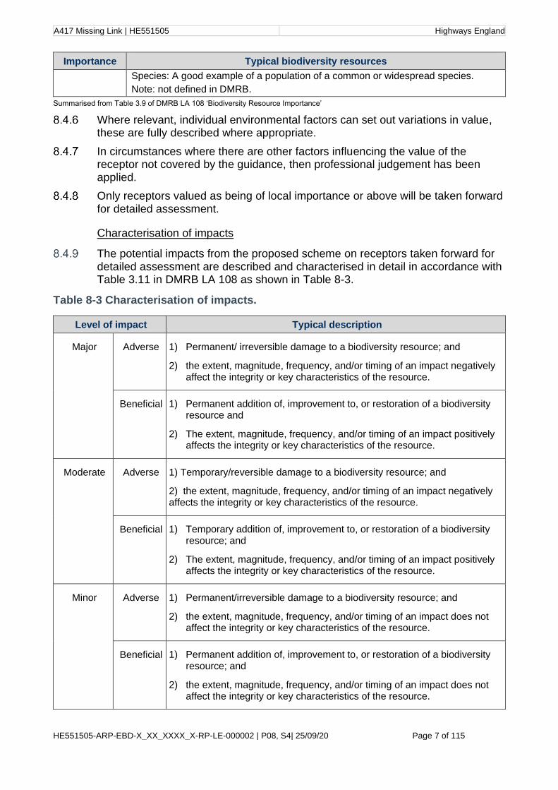
The potential impacts from the proposed scheme on receptors taken forward for detailed assessment are described and characterised in detail in accordance with Table 3.11 in DMRB LA 108 as shown in Table 8-3.
Table 8-3 Characterisation of impacts.
Level of impact Typical description
Major Adverse 1) Permanent/ irreversible damage to a biodiversity resource; and
2) the extent, magnitude, frequency, and/or timing of an impact negatively affect the integrity or key characteristics of the resource.
Beneficial 1) Permanent addition of, improvement to, or restoration of a biodiversity resource and
2) The extent, magnitude, frequency, and/or timing of an impact positively affects the integrity or key characteristics of the resource.
Moderate Adverse 1) Temporary/reversible damage to a biodiversity resource; and
2) the extent, magnitude, frequency, and/or timing of an impact negatively affects the integrity or key characteristics of the resource.
Beneficial 1) Temporary addition of, improvement to, or restoration of a biodiversity resource; and
2) The extent, magnitude, frequency, and/or timing of an impact positively affects the integrity or key characteristics of the resource.
Minor Adverse 1) Permanent/irreversible damage to a biodiversity resource; and
2) the extent, magnitude, frequency, and/or timing of an impact does not affect the integrity or key characteristics of the resource.
Beneficial 1) Permanent addition of, improvement to, or restoration of a biodiversity resource; and
2) the extent, magnitude, frequency, and/or timing of an impact does not affect the integrity or key characteristics of the resource.

A417 Missing Link | HE551505 Highways England
HE551505-ARP-EBD-X_XX_XXXX_X-RP-LE-000002 | P08, S4| 25/09/20 Page 8 of 115
Level of impact Typical description
Negligible Adverse 1) Temporary/reversible damage to a biodiversity resource; and
2) the extent, magnitude, frequency, and/or timing of an impact does not affect the integrity or key characteristics of the resource.
Beneficial 1) Temporary addition of, improvement to, or restoration of a biodiversity resource; and
2) the extent, magnitude, frequency, and/or timing of an impact does not affect the integrity or key characteristics of the resource.
No change No observable impact, either positive or negative.
Table taken from DMRB LA108(Table 3.11 Level of impact and typical descriptions.
The level of impact on biodiversity will also be concluded in accordance with CIEEM’s Guidelines for Ecological Impact Assessment in the UK and Ireland
Zone of influence
The CIEEM Guidelines for Ecological Impact Assessment16 are used to guide the characterisation process. For example, in determining the complexity of the impact (whether it is direct or indirect, and the Zone of Influence (ZoI) of that receptor will be considered). The zone of influence is the area over which ecological features may be subject to significant effects. This area may differ for different receptors. The ZoI is explained in more detail within Section 8.6.
Assessment of significance of effects
In accordance with DMRB LA 104 and DMRB LA108, the significance of effects characterised as Neutral, Slight, Moderate, Large, Very Large and both adverse and beneficial, is determined by assessing the importance of resources/receptors against any residual impact.
In accordance with DMRB LA 108, a significant effect is considered to be any effect of moderate, large or very large categories once mitigation has been taken into account. Significant effects, or impacts which affect receptors protected under legislation, require consideration of avoidance, reduction or mitigation as defined within CIEEM Guidance.
Table 8-4 Significance matrix
Resource importance
Level of Impact
No change Negligible Minor Moderate Major
International or European importance
Neutral Slight Moderate or large
Large or very large
Very large
UK or National importance
Neutral Slight Slight or moderate
Moderate or large
Large of very large
Regional importance Neutral Neutral or slight
Slight Moderate Moderate or large

A417 Missing Link | HE551505 Highways England
HE551505-ARP-EBD-X_XX_XXXX_X-RP-LE-000002 | P08, S4| 25/09/20 Page 9 of 115
County of equivalent authority importance
Neutral Neutral or slight
Neutral or slight
Slight Slight or moderate
Local importance Neutral Neutral Neutral or slight
Neutral or slight
Slight
Table taken from DMRB LA108 (Table 3.13 Significance matrix
The assessment of the significance of effects is also informed by professional judgement and guidance as provided within CIEEM Guidelines17 and the professional judgement of ecologists experienced in the assessment of ecological impacts of major linear infrastructure schemes in the UK.
Stakeholder engagement
Ecologists have been involved in discussion and Technical Working Groups (TWGs) with the Gloucestershire Wildlife Trust (GWT), the National Trust (NT), the Environment Agency (EA), Natural England (NE) and the Woodland Trust. TWG meetings discussed the shared landscape vision for the proposed scheme and more detailed design with regard to the multi-functional crossings, infrastructure crossings and ecological networks. Further details on the consultation relating to biodiversity will be provided in the Statements of Common Ground, which will be submitted with the DCO application.
8.5 Assessment assumptions and limitations.
The findings presented in this chapter represent those available at the time writing and data collected to date. Every effort has been made to ensure that the findings of the study present as accurate an interpretation as possible of the status of flora and fauna within the study area.
Ecological surveys are limited by factors that affect the presence of plants and animals, such as the time of year, migration patterns and behaviour. Surveys undertaken were largely conducted at the optimal survey periods and using standard methodologies accepted by Natural England and other statutory bodies.
Field survey limitations are stated within the individual technical reports accompanying this PEI report chapter.
Where ‘reasonable worst-case’ valuations are necessary they have been made based on the information available. This has included consideration of any available field or desk study data (including aerial photography), a comparison with similar habitat areas occurring in the wider local area, and a qualitative consideration against any factors that indicate suitability for the particular habitat or species in question. The degree of precaution built into the assessment is linked to the level of confidence in the existing data upon which the assessment is based. Most ecological surveys have now been completed but some outstanding surveys are continuing in 2020 when access is permitted to fill in any remaining gaps in baseline data, for example at Emma’s Grove woodland and bat roost assessments and ecological walkovers of areas that were not previously within the study area but are now due to recent alterations to the DCO Boundary.
Since the species of Myotis bat could not be determined at the time of survey relating to the identification of tree roosts (i.e. tree climbing and emergence surveys), and due to the presence of Bechstein’s (Myotis Bechsteinii) bats in the

A417 Missing Link | HE551505 Highways England
HE551505-ARP-EBD-X_XX_XXXX_X-RP-LE-000002 | P08, S4| 25/09/20 Page 10 of 115
area, a precautionary approach was taken to the valuation of such roosts, and they were thus assigned the higher importance.
The proposed scheme includes the demolition of several buildings around Grove Farm. These buildings were previously assessed for their bat roosting potential. Follow-up roost categorisation surveys are now required. Due to current access restrictions and seasonal constraints, a full set of surveys across the main bat activity period (May to September) is unlikely to take place in 2020, however access continues to be sought for survey results to feed into the Environmental Statement (ES).
Access restrictions during badger bait marking surveys in March and April 2019, due to farming practices such as lambing, meant that some areas within 500 metre buffers of main badger setts identified for further survey were not accessible within the bait marking survey period. Typically, this restricted access to 10–30% of the survey area. In the case of one main sett located to the north of Birdlip Quarry (referred to as the Quarry sett) 50% of the area was not accessible for bait marking surveys. However, these areas were previously accessible during the walkover surveys undertaken in September and October 2018 and January and February 2019. It is therefore considered that sufficient baseline information on the presence of main setts on which to undertake bait marking surveys to ascertain the badger territories, has been obtained to inform mitigation design and enough area and habitat features accessible to determine the territory affected by the proposed scheme. This is with the exception of Emma’s Grove Woodland for which detailed surveys are still to be undertaken when access is permitted. Surveys have currently been undertaken here from public footpaths only to allow a broad habitat assessment and to undertake a precautionary assessment of as to whether protected and notable species are likely to be present. Other further surveys required at Emma’s Grove are Woodland National Vegetation Classification (NVC), and tree assessments for bat roosts.
The proposed scheme includes potential drainage work requiring an extension of the DCO boundary into land at the National Star College. A walkover survey is scheduled now that the site has reopened following closure due to COVID-19 pandemic and associated restrictions. The linear area measuring approximately 450 metres by 12 metres includes predominantly semi-improved grassland, broadleaved woodland and amenity grassland (golf course). This land will be considered as an area that would be disturbed and returned to previous land use with the exception of the woodland which would be permanently lost if the works are required. A pond which is stocked for fishing is present within the golf course which is approximately 280 metres west of the potential drainage works and approximately 780 metres from the construction footprint of drainage basins to the north of air balloon roundabout. This pond was not surveyed previously due to being over 500 metres away from the DCO boundary. Once access is permitted a survey of this area including suitability of the pond for great crested newts will be undertaken. Due to seasonal constraints it will not be possible to survey the pond for great crested newts in 2020. Results from these surveys and further assessment will be completed in the Environmental Statement but results are not expected to change current assessments of significant effects.
Due to the absence of baseline fish data from the upper reaches of Norman’s Brook, assumptions on species presence and likely significant effects to fish have been made based on a ‘reasonable worst case’ principle.

A417 Missing Link | HE551505 Highways England
HE551505-ARP-EBD-X_XX_XXXX_X-RP-LE-000002 | P08, S4| 25/09/20 Page 11 of 115
Access limitations prevented survey of some areas within the proposed scheme being surveyed for Roman snail. A precautionary approach is taken and presence is assumed in unsurveyed habitats considered reasonably likely to support Roman snail based upon habitat type (with reference to aerial imagery and existing Phase 1 habitat data) and connectivity to habitats where presence is confirmed.
8.6 Study area
The ecology of the proposed scheme and surrounding area was surveyed primarily over three years between 2017 and 2019, in which time several route options were considered, with the preferred route (option 30) being determined and announced in March 2019 (see Chapter 3 Assessment of alternatives). Additional surveys for bats, invertebrates (both aquatic and terrestrial) and tufaceous vegetation were also conducted in Spring 2020. Historical surveys conducted in 2006 that were undertaken during a Stage 2 Assessment of the proposed scheme options being considered at this time, were also taken into consideration. These ecological surveys partly covered the study areas being considered here.
The study area varied for different species and ecological survey methods to ensure compliance with specific guidance for species, groups and habitats.
The overall study area is shown on the Phase 1 Habitat Map provided in Figure 8.3.
The maximum extent of the study areas was determined by guidance, the predicted Zone of Influence18 (ZoI) of the proposed scheme and consultation with statutory bodies. For example, surveys for badger extended at least 500 metres from the proposed scheme, as per DMRB standard LD 118 Biodiversity design19. Where there are any deviations from guidance, these are described and justified within the assessment and ecological baseline reports within PEI report Appendices 8.1 to 8.24.
Table 8-5 provides a summary of the desk study and field study area distances applied for each ecological receptor surveyed for the proposed scheme; specific guidance used are provided below for each biodiversity receptor considered.
Table 8-5 Summary of the study area distances considered for each biodiversity receptors considered
Biodiversity receptor Distance from proposed scheme
Internationally designated nature conservation sites, including Special Areas for Conservation (SAC), SPA and Ramsar Sites (in line with DMRB LA 115 Habitats Regulations Assessment (January 2020.
1.2 miles (2km)
SACs designated for bat populations in line with DMRB LA 115 Habitats Regulations assessment (January 2020).
18.6 miles (30km)
Internationally designated nature conservation sites which are linked hydrologically to watercourses potentially affected by the proposed scheme options.
Hydrologically connected sites
Nationally and locally designated nature conservation sites, including NNR, SSSI, Local Nature Reserves (LNR), priority habitats, Local Wildlife Sites (LWS), ancient
1.2 miles (2km)
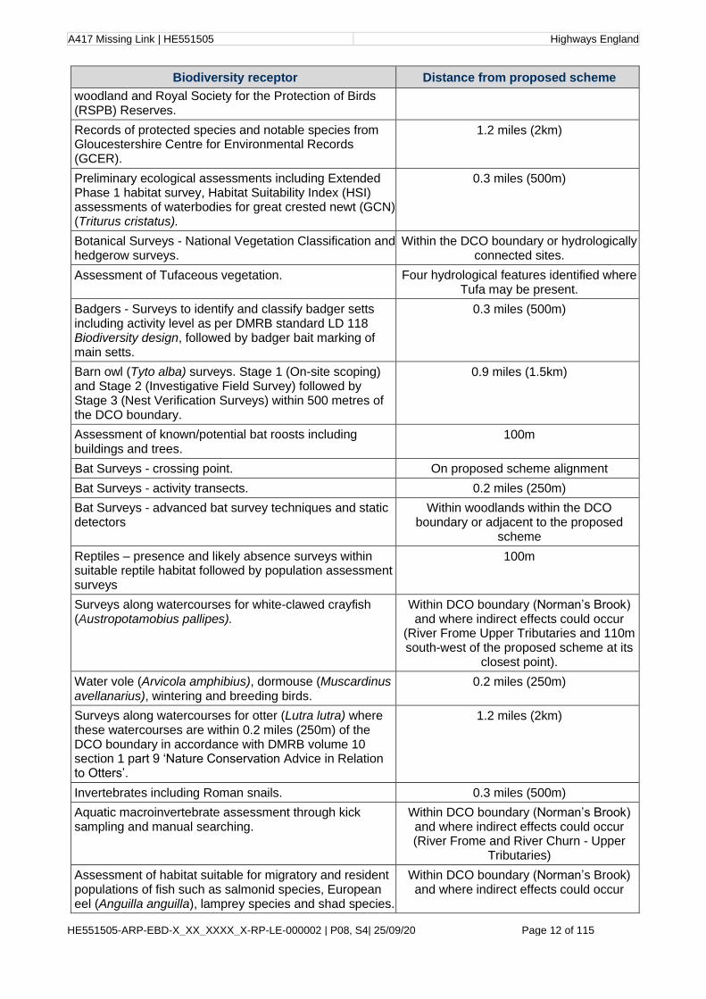
A417 Missing Link | HE551505 Highways England
HE551505-ARP-EBD-X_XX_XXXX_X-RP-LE-000002 | P08, S4| 25/09/20 Page 12 of 115
Biodiversity receptor Distance from proposed scheme
woodland and Royal Society for the Protection of Birds (RSPB) Reserves.
Records of protected species and notable species from Gloucestershire Centre for Environmental Records (GCER).
1.2 miles (2km)
Preliminary ecological assessments including Extended Phase 1 habitat survey, Habitat Suitability Index (HSI) assessments of waterbodies for great crested newt (GCN) (Triturus cristatus).
0.3 miles (500m)
Botanical Surveys - National Vegetation Classification and hedgerow surveys.
Within the DCO boundary or hydrologically connected sites.
Assessment of Tufaceous vegetation. Four hydrological features identified where Tufa may be present.
Badgers - Surveys to identify and classify badger setts including activity level as per DMRB standard LD 118 Biodiversity design, followed by badger bait marking of main setts.
0.3 miles (500m)
Barn owl (Tyto alba) surveys. Stage 1 (On-site scoping) and Stage 2 (Investigative Field Survey) followed by Stage 3 (Nest Verification Surveys) within 500 metres of the DCO boundary.
0.9 miles (1.5km)
Assessment of known/potential bat roosts including buildings and trees.
100m
Bat Surveys - crossing point. On proposed scheme alignment
Bat Surveys - activity transects. 0.2 miles (250m)
Bat Surveys - advanced bat survey techniques and static detectors
Within woodlands within the DCO boundary or adjacent to the proposed
scheme
Reptiles – presence and likely absence surveys within suitable reptile habitat followed by population assessment surveys
100m
Surveys along watercourses for white-clawed crayfish (Austropotamobius pallipes).
Within DCO boundary (Norman’s Brook) and where indirect effects could occur
(River Frome Upper Tributaries and 110m south-west of the proposed scheme at its
closest point).
Water vole (Arvicola amphibius), dormouse (Muscardinus avellanarius), wintering and breeding birds.
0.2 miles (250m)
Surveys along watercourses for otter (Lutra lutra) where these watercourses are within 0.2 miles (250m) of the DCO boundary in accordance with DMRB volume 10 section 1 part 9 ‘Nature Conservation Advice in Relation to Otters’.
1.2 miles (2km)
Invertebrates including Roman snails. 0.3 miles (500m)
Aquatic macroinvertebrate assessment through kick sampling and manual searching.
Within DCO boundary (Norman’s Brook) and where indirect effects could occur (River Frome and River Churn - Upper
Tributaries)
Assessment of habitat suitable for migratory and resident populations of fish such as salmonid species, European eel (Anguilla anguilla), lamprey species and shad species.
Within DCO boundary (Norman’s Brook) and where indirect effects could occur

A417 Missing Link | HE551505 Highways England
HE551505-ARP-EBD-X_XX_XXXX_X-RP-LE-000002 | P08, S4| 25/09/20 Page 13 of 115
Biodiversity receptor Distance from proposed scheme
(River Frome and River Churn - Upper Tributaries)
A desk study was carried out, followed by field studies. Definition of the desk and field study areas follows DMRB LD 118 Biodiversity design and other available sources of survey good practice guidance referenced below and in PEI report Appendices 8.1-8.24.
Desk study
A desk study was undertaken in 2017 to collate and review records of statutory and non-statutory designated sites, protected and notable species and notable habitats within 1.2 miles (2 kilometres) of the options being considered at the time. This search area was extended to 18.6 miles (30 kilometres) for SACs where bats are a qualifying species. This desk study was updated in December 2019 to account for any additional protected and notable species and notable habitat records since the date of the first desk study search and to ensure that the age of the ecological data used to inform the assessment is no older than 12 – 18 months, in line with CIEEM guidance20.
The following organisations and resources were consulted to compile the desk study:
• Multi-Agency Geographic Information for the Countryside (MAGIC) (Defra);
• Gloucestershire Centre for Environmental Records (GCER);
• additional habitat and protected and notable species data were provided by the National Trust (NT) and Gloucestershire Wildlife Trust (GWT) for records around Crickley Hill and Barrow Wake SSSI (comprising Crickley Hill and Barrow Wake Nature Reserve);
• National Trust report (2015): Nature Conservation Evaluation, Crickley Hill, Gloucestershire;
• additional records of horseshoe bats were provided by Dr Roger Ransome in December 2019;
• National Trust report by Dr K. Alexander (2019): Crickley Hill baseline saproxylic invertebrate survey; and
• Woodland Trust, for records of veteran trees
• Environment Agency freshwater fish records
In 2006, a Stage 2 Assessment of a scheme which covered the options considered at the time was undertaken and results reported in the A417 Cowley to Brockworth Bypass Improvement Scheme - Stage 2 Ecology and Nature Conservation Report21. Key findings of this report formed part of the desk study and they are considered within this chapter.
Extended Phase 1 habitat survey
The Extended Phase 1 habitat survey was carried out in May and June 2017. The broad habitat types were identified and mapped in accordance with the Handbook for Phase 1 Habitat Survey22.
During the Extended Phase 1 survey, features of potential significance to protected species were identified and recorded as target notes which are included in Appendix 8.1 Phase 1 habitat survey. These included habitats of potential significance or evidence of or potential for any protected or notable species.
A417 Missing Link | HE551505 Highways England
HE551505-ARP-EBD-X_XX_XXXX_X-RP-LE-000002 | P08, S4| 25/09/20 Page 14 of 115
Habitats within the Zol were classified according to Joint Nature Conservation Committee (JNCC) habitat types and are shown on the Phase 1 Habitat map in Figure 8.3. Where possible, plant species were identified to species level. The species lists were compiled and incorporated into the Preliminary Ecological Appraisal report23. Further details on the methodology and limitations can be found in the Preliminary Ecological Appraisal report24.
Habitats mapped in the original Phase 1 habitat survey were verified and updated where possible during subsequent field surveys in 2019.
River habitat survey
During initial scoping, watercourses within the proposed scheme and the wider catchment likely to be impacted by the works were noted. River Habitat Surveys and fish habitat assessments were conducted in October 2019 and January 2020 to record information on aquatic habitats within the study area and their suitability to support notable aquatic species.
River Habitat Surveys were undertaken in accordance with the methodology outlined within River Habitat Survey in Britain and Ireland; Field Survey Guidance Manual; Version 325.
In broad terms, the River Habitat Survey is a method designed to characterise and assess the physical structure of freshwater streams and rivers. Using the application of a set of rules to River Habitat Survey data, artificial modification to the physical structure of the river channel (e.g. channel realignment, weirs, culverts, sluices, bridges) can be expressed as a Habitat Modification Score, which are used to assign a Habitat Modification Class (HMC) for each watercourse.
In addition to assessing level of river modification, a Habitat Quality Assessment score can be determined, which is a broad measure of the diversity and ‘naturalness’ of the physical (habitat) structure of a site. Habitat Quality Assessment scores are used to rank a given site within 150 similar sites automatically selected from the River Habitat Survey database, to provide an indicative habitat quality class from “Very Low” to Very High”.
A River Habitat Survey was undertaken along 500 metre lengths of two watercourses in October 2019: Norman’s Brook upstream of the A417; and January 2020: Norman’s Brook downstream of the A417 and Horsbere Brook. Observations were made at ten equally spaced spot-checks along the watercourse. A sweep-up along the whole 500 metres length included features not occurring on the spot-checks.
Fish habitat assessment
Fish habitat assessment consisted of mapping fish habitat according to habitat types adapted from the EA Fisheries Technical Manual 4 - Restoration of riverine salmon habitats26 and Monitoring the River, Brook and Sea Lamprey27. The main objective of the method is to obtain a detailed representation of the precise location, extent, condition and juxtaposition of fish habitats within the wetted width of the river. This is recorded by walking the riverbank and annotating high resolution maps with the habitats present. Fish habitat types are defined by the interaction of the following variables: water depth; water velocity; substrate composition; and cover. Fish habitat assessments were completed in six reaches

A417 Missing Link | HE551505 Highways England
HE551505-ARP-EBD-X_XX_XXXX_X-RP-LE-000002 | P08, S4| 25/09/20 Page 15 of 115
located in Norman’s Brook, Horsbere Brook, and tributaries of the River Churn and River Frome.
To supplement the fish habitat assessment and understand the connectivity of river habitat for fish, in-stream obstacles to fish passage including natural obstacles, weirs, sluices, culverts and fords were recorded.
The detailed methodology used for River Habitat Survey and fish habitat assessment are detailed in Appendix 8.23 Fish habitat assessment report.
Tufaceous vegetation survey
Four hydrological features where potential for tufaceous28 vegetation had been identified were assessed in March 2020, as follows:
• two features along a tributary of Norman’s Brook south of the A417 near Crickley Hill - G231 and G81, at Ordnance Survey National Grid Reference SO 9281 1573 and SO 9240 1570 respectively; and
• two features near Watercombe Farm, Brimpsfield - G111 and an un-named spring and rivulet rising nearby in Bushley Muzzard, Brimpsfield SSSI at SO 9439 1318 and SO 9434 1342 respectively.
In the absence of a standard methodology for this type of assessment, the methodology used to assess tufaceous vegetation was based on professional judgement informed by the research work undertaken by Farr, Graham and Stratford in 201429. Each feature was visually appraised to determine the ecological boundary of the tufa formation (where present) and its associated vegetation. This focussed on homogenous vegetation dominated by specific types of moss (Palustriella and/or Cratoneuron filicinum) which was subsequently mapped, along with locations of individual spring heads, runnels (small streams) and tufa.
Vascular plants, bryophytes (mosses, liverworts and hornworts) and macroalgae were recorded for each feature with the occurrence of each species recorded using the DAFOR scale30. Where a feature was in woodland, woody species were noted only where they were rooted within the feature.
Where possible, features were visually assigned to National Vegetation Classification (NVC) communities (described in further detail in NVC survey methodology section). Where the M37 Palustriella commutata - Festuca rubra spring community was found to be present, a condition assessment was undertaken against attributes and targets indicated by Common Standards Monitoring (CSM) guidance31.
Further details on the methodology and survey locations can be found in Appendix 8.24 Assessment of tufaceous vegetation.
Hedgerow surveys
All hedgerows within the area of the proposed scheme and within a 50 metre buffer were assessed within the optimal period in June 2019. Survey methodology followed that laid out in the Hedgerow Survey Handbook 200732, and the Hedgerows Regulations 199733, and the hedgerow importance was assessed following the criteria provided in Part II of Schedule 1 of the Hedgerows Regulations 1997. These criteria include, but are not limited to, features such as the presence and/or abundance of woody species, connections with other
A417 Missing Link | HE551505 Highways England
HE551505-ARP-EBD-X_XX_XXXX_X-RP-LE-000002 | P08, S4| 25/09/20 Page 16 of 115
ecological features, rare tree species, and woodland ground flora species. The aims of the hedgerow assessment were to:
• identify hedgerows that are classified as ‘important’ under the Wildlife and Landscape criteria of the Hedgerows Regulations 1997; and
• identify hedgerows that, although not deemed ‘important’ under the ecological criteria of the Hedgerows Regulations 1997, have ecological value in terms of species diversity or as potential wildlife corridors.
Further details on the methodology and limitations can be found in Appendix 8.2 Hedgerow technical report.
National vegetation classification (NVC) surveys
NVC surveys were undertaken for woodland in May 2019, and for grassland in July and August 2019, following best practice guidelines and standard methodology34 35.
Woodland sites within 200 metres of the proposed scheme were scoped in for NVC surveys if they had the potential to support protected or notable plant species, were designated for their botanical interest, and/or were listed on the Ancient Woodland Inventory. This distance was used to account for potential air quality impacts which have potential to have adverse impacts within 200 metres of the air pollution source. The areas surveyed are shown in Appendix 8.3 NVC woodland survey report.
Grassland sites scoped in for NVC surveys were based on the Phase 1 Habitat Survey carried out in 2017, which indicated the potential presence of grassland of conservation importance in these areas and targeted for more detailed botanical investigation. The areas surveyed are shown in Appendix 8.4 Botanical assessment.
Grasslands within a total of five sites, and woodlands within a total of 25 sites considered to support habitat of sufficient quality to be subject to detailed NVC survey were shortlisted and prioritised for further survey.
Plant species are named in accordance with guidance36 except for the naming of NVC communities, which are based on detailed descriptions of vegetation communities provided by Rodwell37.
Further details on the methodology and limitations, including figures, can be found in Appendix 8.4 Botanical assessment and Appendix 8.3 NVC woodland survey report.
Bat surveys
The survey methodologies followed current best practice guidelines38, and relevant sections of the DMRB39 40. The survey methodologies were broadly in line with best practice methodology for surveying linear infrastructure41. Consultation was undertaken with Natural England in 2017 to agree the survey methodology.
Bat roost surveys
Ground level tree assessments
Trees within 100 metres of the proposed scheme options at the time of survey were surveyed from ground level in summer 2018, using binoculars and a torch,

A417 Missing Link | HE551505 Highways England
HE551505-ARP-EBD-X_XX_XXXX_X-RP-LE-000002 | P08, S4| 25/09/20 Page 17 of 115
where appropriate, to obtain an initial judgement of the depth of any potential roost features (PRF). Trees were classified according to their potential to support roosting bats; as negligible, low, moderate of high, taking into account its connectivity to the wider environment and position in the context of the landscape.
Further details on the methodology and limitations, including figures showing the survey locations can be found in Appendix 8.5 Bat roost surveys technical report.
Aerial tree climbing surveys
To provide further assessment of trees with potential to be affected by the proposed scheme, aerial inspection surveys were undertaken. The scope of trees assessed by aerial inspection followed the survey buffers as agreed with Natural England. This included all high potential trees within 100 metres of the proposed scheme footprint and all trees with moderate potential to support roosting bats within 20 metres of the proposed scheme footprint. In accordance with best practice guidelines42, trees with low potential were not subject to further survey. The surveys were carried out by licenced bat workers and certified tree climbers, using a rope access system, torches and endoscopes.
Tree climbing surveys were undertaken in 2018 and 2019. This survey enabled PRFs to be inspected up close and larger features were inspected using an endoscope to allow a more accurate assessment of the potential of a tree to support roosting bats. Each tree, where safe to do so, was subject to a single aerial inspection. Following the inspection, the potential for a tree to support roosting bats was either:
• Upgraded: aerial inspection allowed for a better assessment of features and revealed that features were more suitable than originally thought from the ground level assessment;
• Downgraded: the aerial advantage point allowed for reducing the potential of features, or even ruling them out altogether as having roosting potential;
• Confirmed the classification for each PRF attributed during the ground level assessment; or
• Confirmed roosting bats, where evidence of current use was identified. This may be the presence of bats themselves, fresh droppings or fresh staining.
Further details on the methodology and limitations, including figures, can be found in Appendix 8.5 Bat roost surveys technical report.
Internal inspections surveys
Internal building inspections were not undertaken at the same time as the external assessments due to the increased intrusiveness of these surveys. To reduce the impact of the assessment on landowners and also to ensure a proportionate approach, internal building surveys were only undertaken following the preferred route announcement in May 2019. Internal building inspections were undertaken in August and September 2019.
Buildings selected for internal surveys were based on the survey buffers agreed with Natural England in 2017. This included all high potential buildings within 100 metres of the proposed scheme footprint, all buildings with moderate potential to support roosting bats within 20 metres of the proposed scheme footprint, and all buildings with low potential to support roosting bats which would be directly impacted. All internal building inspections were undertaken by a pair of surveyors,

A417 Missing Link | HE551505 Highways England
HE551505-ARP-EBD-X_XX_XXXX_X-RP-LE-000002 | P08, S4| 25/09/20 Page 18 of 115
at least one of which held a current Natural England Class 1 bat licence as a minimum.
Where possible and safe to do so, surveyors accessed all areas within the building, including attic, loft species, and cellars. High-powered torches with red filters, binoculars and endoscopes were used to assess all accessible areas, with any access constraints recorded in survey notes and fed into the assessment of the building.
Where droppings were found, a small sample considered to be representative of each species within the roost were collected and sent off for DNA analysis by the University of Warwick to confirm species. Where droppings were characteristic of a species and a positive identification could be made by a licenced bat worker, droppings were not sent for analysis.
Using the results from the internal building inspections, buildings were then reclassified for their potential to support roosting bats.
Further details on the methodology and limitations, including figures, can be found in Appendix 8.5 Bat roost surveys technical report.
Dusk emergence and dawn re-entry surveys
Emergence and re-entry surveys were undertaken on identified buildings, bridges and trees to provide an assessment of the presence or likely absence of roosting bats from these features.
Buildings and trees within the construction footprint assessed as having moderate or high potential to support roosting bats were included in emergence and re-entry surveys during 2018 and 2019. In accordance with best practice guidelines and standard methodology43, trees with low roost potential were not subject to further surveys. As agreed with Natural England, low potential buildings were to be scoped in if any low potential buildings were within the works footprint. Buildings and trees with moderate and high suitability within 20 metres and 100 metres of the construction footprint, respectively, were included, in accordance with survey buffers agreed with Natural England. Buildings and trees identified as having negligible potential did not require further surveys.
Survey effort was determined by roosting potential, outlined within standard best practice guidelines44. Surveyor numbers were sufficient for each survey, ensuring all PRFs were visible by at least one person. Potential access and egress points were made known to surveyors before surveys began. Visual contact was made throughout the survey and surveyors remained at their feature locations to provide sufficient coverage.
Evening emergence surveys commenced between 15 and 30 minutes before sunset and ended two hours after sunset. Dawn re-entry surveys began two hours before sunrise and ended 15 minutes after sunrise but continued for up to 30 minutes after sunrise if bats were recorded after sunrise.
Surveys were undertaken in line with standard best practice guidelines45, with surveys taking place between May and October (weather permitting). Features of high potential were surveyed three times, with at least two of these occurring in the core season between May and August. Moderate potential features were surveyed twice, with at least one between May and August. Low potential building features were surveyed once during the core season. There was a minimum two-week gap between repeat surveys.
A417 Missing Link | HE551505 Highways England
HE551505-ARP-EBD-X_XX_XXXX_X-RP-LE-000002 | P08, S4| 25/09/20 Page 19 of 115
Surveyors were equipped with full spectrum bat detectors which primarily included either Anabat Walkabout or Elekon Bat Logger full spectrum bat detectors, which recorded bat calls during the survey. Species were identified during the survey and subsequently sound files were analysed using either Anabat Insight or BatExplorer software to confirm species.
Further details on the methodology and limitations, including figures, can be found in Appendix 8.5 Bat roost surveys technical report.
Hibernation surveys
Based on the preliminary roost assessments undertaken in 2018, several buildings and features were determined to have suitable hibernation roosting potential. Features of high hibernation potential included where buildings were likely to have cellars or other structures likely to have stable cool and humid conditions. A review was undertaken to identify any caves or other underground features which could provide suitable hibernation conditions within 100 metres of the proposed scheme.
Where potential hibernation roosts were identified, hibernation surveys were carried out in line with standard best practice guidelines46. Potential structures and caves were subject to an initial winter inspection during which an assessment of the sites suitability to support hibernating bats was made. Surveys were led by a holder of a Natural England Class II bat licence as a minimum.
Where suitable hibernation habitat was confirmed to be present, or where an internal inspection was not possible, a Wildlife Acoustics SM4 full spectrum bat detector was deployed during the first inspection and left in situ for the duration of the hibernation season. Surveys were undertaken between January and March 2019. Subsequent analysis of bat calls recorded on the SM4 bat detectors was undertaken using Kaleidoscope Pro software, with bat calls auto identified and then manually checked.
Further details on the methodology and limitations, including figures, can be found in Appendix 8.5 Bat roost surveys technical report.
Bat activity surveys
Bat activity transect surveys
Using the Phase 1 Habitat survey information collected in 2017 and aerial imagery, seven transect routes were designed to provide adequate coverage (where access allowed) to all suitable bat foraging and commuting habitat within 250 metres of the DCO boundary. Each transect route was surveyed a total of seven times over the active bat periods of 2018 and 2019, with a transect undertaken for each of the active months (April to October). Commencement of surveys and months surveyed each year were dependent on the dates when land access was granted. July transects were completed as dusk/dawn surveys within 24 hours.
Dusk transects began at sunset and lasted for three hours afterwards to account for late-emerging bat species; notably the horseshoe bat (Rhinolophus spp) species. Dawn transects started three hours before sunrise, finishing at sunrise. Transects were walked at a steady pace and the direction of passage was alternated each time the route was walked to ensure that different areas of each transect was sampled at different times before/after sunrise/sunset.

A417 Missing Link | HE551505 Highways England
HE551505-ARP-EBD-X_XX_XXXX_X-RP-LE-000002 | P08, S4| 25/09/20 Page 20 of 115
Two full spectrum detector models were used, the Anabat Walkabout and Batlogger M, to record sound files throughout the transect survey. These were then analysed using their respective software, Batlogger M was analysed with Bat Explorer and Anabat Walkabouts with Anabat Insight. Analysis of the bat passes to create heat maps of bat activity were undertaken using ArcGIS and the Kernel density tool.
Further details on the methodology and limitations, including figures showing the transect routes and species heat maps, can be found in Appendix 8.6 Bat activity survey report.
Automated detector surveys
Three static detectors were installed for each transect, resulting in a total deployment of 21 detectors, in line with standard best practice guidelines47. An additional detector (5D) was placed within the Shab Hill woodland for part of the survey season to provide supplementary information on bat activity within the woodland, as a number of lesser horseshoe (Rhinolophus hipposideros) passes had been recorded during emergence surveys in this location. Each detector was deployed for one week per month between April and October over the bat active periods in 2018 and 2019, to collect data over five consecutive nights per month. Static detectors were set up to begin recording 30 minutes before sunset and stop recording 30 minutes after sunrise. Static detectors were deployed within a range of suitable habitats considered to be directly or indirectly affected by the proposed scheme.
Analysis of bat calls was undertaken using Wildlife Acoustics Kaleidoscope Pro software. Comparison and analysis of data collected during static surveys was undertaken using Microsoft Excel spreadsheets and pivot tables. Additionally, the data was analysed using the Ecobat tool48.
Further details on the methodology and limitations, including figures showing the location of static detectors, can be found in Appendix 8.6 Bat activity survey report.
Bat crossing point surveys
Following a review of the data gathered during the 2018 bat activity transect surveys, and based on land access at the time, seven bat crossing point locations were chosen along the proposed scheme alignment. Six surveys were carried out between June and September 2019. The surveys were carried out in accordance with best practice guidelines and methodology49 which was adapted for pre-construction surveys. The surveys consisted of visual observations of bats along the linear habitat feature to be crossed by the proposed scheme, over a minimum of 60 minute periods at dusk or dawn (this was extended to 90 minute for the proposed scheme due to the presence of barbastelle bats (Barbastella barbastellus) and other late emerging species such as horseshoe bat species).
Two surveyors monitored each crossing point (one surveyor located either side of the proposed route and where possible on opposite sides of the feature). Bats were considered to be ‘using the feature’ if individuals crossed the proposed scheme in a horizontal direction (roughly parallel) to the linear feature and within 5 metres of it. Bats were considered to be crossing the proposed scheme but not using the linear feature when bats were recorded parallel to the feature but further than 5 metres from it. Bats were not considered to be crossing the proposed

A417 Missing Link | HE551505 Highways England
HE551505-ARP-EBD-X_XX_XXXX_X-RP-LE-000002 | P08, S4| 25/09/20 Page 21 of 115
scheme if they were recorded to be flying perpendicular to the linear feature (and not crossing the proposed scheme in between surveyors). Bats were considered to be flying at a safe height if they were flying at 5 metres or more above ground, and at an ‘unsafe height’ if flying below 5 metres high.
Further details on the selection process for each location, methodology and limitations can be found in Appendix 8.7 Bat crossing point survey report, and in 8.21 to 8.27.
Bat trapping and radio-tracking surveys
Investigating the habitat use and roost locations of horseshoe, barbastelle and tree-roosting bats is generally considered highly challenging, due to their frequent roost movements, flight behaviour and in the case of barbastelle bats specifically, large home ranges (Zeale, Davidson-Watts and Jones, 201250). Therefore, trapping of bats and the fixing of radio transmitters (tags) from which individual bats could be followed using radio telemetry receivers, was used in order to present a robust data set of the use of the site and surrounding areas by horseshoe, barbastelle and other significant populations of tree-roosting bats.
Three survey sessions of approximately one to two weeks duration were undertaken in July and September 2019, and in May 2020. The survey session included the trapping of bats at various locations, predominantly in forest/tree-dominated habitats adjacent to or within the DCO boundary. In accordance with the conditions of Natural England licences 2019-40186-SCI-SCI (for the work in July and September 2019) and 2020-46090-SCI-SCI-1 (for the work in May 2020) and survey objectives, target bats were radio-tagged which included the primary species of interest: horseshoe bat species, Bechstein's bat and barbastelle bat (all four UK species listed on Annex II of the Habitats Directive) and secondary priority species including other bats from the genus Myotis and Nyctalus.
Tagged bats were simultaneously or subsequently followed by radio-tracking teams during the survey session to locate and identify roost sites and to examine nocturnal flying activity of the tagged bats, with a focus on collecting activity data for bats within the proposed scheme’s ZoI and other key areas considered potentially important to Annex II bat population(s). Where access was possible to roost sites, emergence counts were undertaken at identified roosts to determine the status/function of the roost.
The methods were undertaken in line with Advanced licensed bat survey methods in Collins, 201651.
Further details on the methods, trapping locations and radio-tracking analysis can be found in Appendix 8.8 Advanced bat surveys technical report.
Badger surveys
Habitats within 500 metres of the proposed scheme options at the time of the survey in 2018 were assessed for their capacity to support badger. Areas of broadleaved woodland, scrub, hedgerow networks, and semi-improved and unimproved grassland provide excellent badger habitat for sett construction and foraging, with good connectivity to the wider landscape.
Initial walkover surveys in September and October 2018 and January and February 2019 were carried out to identify badger setts and other signs of habitat use. Incidental badger signs were also recorded throughout the 2018 and 2019

A417 Missing Link | HE551505 Highways England
HE551505-ARP-EBD-X_XX_XXXX_X-RP-LE-000002 | P08, S4| 25/09/20 Page 22 of 115
survey season. Evidence of setts, latrines, scratching, snuffle (foraging) holes, hairs, and footprints were searched for. The level of badger activity was also assessed and classified as well used, partially used, or disused. All connected and accessible land within 500 metres of the proposed scheme footprint was thoroughly searched for badger field signs, in line with best practice guidelines from DMRB52 and Cresswell et al. (1990)53.
Following the identification of badger habitats and field signs, more detailed survey work was considered necessary to confirm activity within the proposed scheme footprint. Badger bait marking surveys of main setts were undertaken in March and April 2019 to establish the territories of each badger clan and provide information on whether the new road would cause fragmentation to these territories. The field survey methodology included a range of survey techniques to identify and define badger activity across the study area, and to characterise the status of potential setts found within a 500 metre buffer of the proposed scheme54.
Further details on the methodology and limitations, including figures, can be found in Appendix 8.9 Badger survey report CONFIDENTIAL.
Bird surveys
Breeding bird surveys
Targeted breeding bird surveys were carried out between April and June 2019. A total of six surveys were completed, in accordance with the Common Bird Census (CBC) and Royal Society for the Protection of Birds (RSPB) survey guidance55
.
This approach involved walking a pre-determined transect route designed to cover all of the habitats present within the survey area with a focus upon those that were likely to be directly affected by the scheme options (at the time of survey design). Due to the size of the survey area, the southern and western parcels of land were surveyed separately. The transect route is shown on Map 1 within Appendix 8.10 Breeding bird technical report.
During each survey, the bird species and behaviour were recorded using the standard British Trust for Ornithology (BTO) codes. A summary of each visit across the breeding season was carried out, identifying the number of species, those of conservation concern, and the primary habitats that those species appeared to be using. The approximate numbers of breeding pairs of each species were also established.
Further details on the methodology and limitations, including figures, can be found in Appendix 8.10 Breeding bird technical report.
Wintering bird surveys
A total of six surveys were undertaken between October 2018 and February 2019 following the same transect as the breeding bird surveys (as described above). As with breeding birds, surveys were conducted following the CBC and RSPB survey guidance56, with species and behaviour being recorded using the standard British Trust for Ornithology (BTO) codes. The transect route is displayed on Map 1 within Appendix 8.11 Wintering bird survey report.
Species that were of conservation importance were mapped to illustrate the ‘hotspots’ within the survey area for wintering species. Again, as with breeding

A417 Missing Link | HE551505 Highways England
HE551505-ARP-EBD-X_XX_XXXX_X-RP-LE-000002 | P08, S4| 25/09/20 Page 23 of 115
birds, each survey was summarised to provide a species list and relative use of the habitats found within each transect.
Further details on the methodology and limitations, including figures, can be found in Appendix 8.11 Wintering bird survey report.
Barn owl surveys
Barn owl surveys were carried out between March and August 2019, using best practice guidance from Shawyer 201157. Stage 1 (On-site scoping) and Stage 2 (Investigative Field Survey) were combined into one walkover undertaken in March and April 2019 within 0.9 miles (1.5 kilometres) of the proposed scheme at the time of survey. Stage 3 (Nest Verification Surveys) were completed in July/August 2019 within 500 metres of the proposed scheme.
The combined Stage 1 and Stage 2 surveys involved a walkover of the survey area during daylight hours to identify trees, buildings, cliffs, caves or nest boxes which could offer any of the following: Potential Nest Site (PNS); Occupied Breeding Site (OBS); Active Roost Site (ARS); and/or Temporary Roost Site (TRS).
Habitat mapping was classified based upon the apparent condition and likelihood of supporting barn owl prey species (such as voles) with habitats categorised as Type 1 (optimum habitat to support prey species), Type 2 (sub-optimal habitat to support prey species), Type 3 (very poor habitats for prey species) or other habitats (non-grassland habitats such as arable fields or mature woodland).
Nest and roost identification followed standard methodology, as above, with features recorded categorised as a PNS, an ARS, or a TRS for barn owls. During the Stage 3 nest verification survey, nest sites identified in Stage 2 as PNSs or ARSs were surveyed to confirm if any could be categorised as OBS.
Where it was deemed unsafe to access a PNS (e.g. building considered unsafe or PNS too far from ground), dusk observational surveys were undertaken to detect any owls emerging and/or adults arriving to site with food, which would confirm breeding.
Further details on the methodology and limitations, including figures, can be found in Appendix 8.12 Stage 1 and 2 Barn Owl survey report CONFIDENTIAL, Appendix 8.13 Stage 3 Barn Owl survey report CONFIDENTIAL and in Figures 8.15 to 8.19.
Dormouse surveys
Suitable hazel dormouse habitat was identified whilst undertaking an extended Phase 1 habitat survey in 2017. A further habitat suitability assessment was undertaken in April and May 2018 which identified 13 areas of potential dormouse habitat within 250 metres of the two proposed scheme options under consideration at the time.
Presence/absence surveys were carried out at these sites between May 2018 and September 2019 following good practice guidance58. Installation dates were dependent on access agreements being in place and therefore varied across the different sites. A minimum of 50 nest tubes were deployed in suitable and connected habitat at each site and checked monthly during the active season (April to November inclusive).
A417 Missing Link | HE551505 Highways England
HE551505-ARP-EBD-X_XX_XXXX_X-RP-LE-000002 | P08, S4| 25/09/20 Page 24 of 115
Further details on the methodology and limitations, including figures, can be found in Appendix 8.14 Dormouse survey report.
Great crested newt surveys
All ponds and potentially suitable waterbodies identified within 500 metres of the route options 12 and 3059 were assessed for their suitability to support great crested newts using the standardised Habitat Suitability Index (HSI) methodology60. Forty ponds were identified within 500 metres of the proposed scheme at the time of survey and 35 were accessible to undertake HSI surveys in Spring 2018. A map showing the location of these waterbodies can be found within Appendix C of Appendix 8.15 Great crested newt survey report. Further Environmental DNA (eDNA) surveys were undertaken on all waterbodies with habitat considered suitable to support great crested newts to confirm presence or likely absence of the species in June 2018 and May 2019. This included waterbodies with HSI scores between 0.5 or more (i.e. ponds with suitability above poor suitability) although the HSI scores were not used to rule out any waterbodies. All surveys were led by a Natural England great crested newt class licence holder.
In addition, six population estimate surveys were undertaken on one pond within 250 metres of the proposed scheme during May 2019 following a positive eDNA result. Population estimate surveys were started on another pond which had negative eDNA results but was adjacent to Pond 2. The surveys were undertaken in accordance with best practice guidelines61. At least three survey methods were utilised for each visit. Surveys were undertaken by experienced ecologists holding a Natural England great crested newt class licence.
Further details on the methodology and limitations, including figures, can be found in Appendix 8.15 Great crested newt survey report.
Due to an extension in the DCO boundary for potential drainage works at Bentham Lane at the west of the scheme, several more ponds at Bentham now fall within 500 metres of the DCO boundary since the original assessment. Desk study data for records of great crested newts has been obtained for these ponds.
As mentioned in the limitations, due to a similar change to the proposed DCO boundary for drainage works at the north of the proposed scheme, a further pond at National Star College Golf Course is yet to be surveyed.
Reptile surveys
A habitat suitability assessment was completed identifying all suitable reptile habitat within 100 metres of the proposed scheme, which is the likely distance the proposed scheme impacts are to extend for reptiles. From this initial assessment 50 sites were identified which required further investigation.
During the initial site visits in May 2018, 18 of the 50 sites were identified as offering suitable habitat to support common reptile populations. Of the 18 sites, 17 were subject to further presence/absence surveys carried out between June and October 2018 and March to June 2019. A mix of corrugated tin, onduline and roofing felt tiles measuring 0.5 metres by 0.5 metres were deployed at each of the 17 sites with the potential to support reptiles, in areas of suitable habitat. One site monitoring was undertaken by South Gloucester Amphibian and Reptile Group (SGARG).

A417 Missing Link | HE551505 Highways England
HE551505-ARP-EBD-X_XX_XXXX_X-RP-LE-000002 | P08, S4| 25/09/20 Page 25 of 115
Sites were initially subjected to seven visits to determine presence or likely absence. Following these initial surveys, the number of surveys was extended to twenty visits to provide a more accurate estimate of population sizes on the sites where presence had been confirmed. Surveys were undertaken in suitable weather conditions, between June and October 2018 and March to September 2019. Population size and importance of reptile population was assessed according to categories described under Froglife Advice Sheet 10: Reptile Survey62.
Further details on the methodology and limitations, including figures, can be found in Appendix 8.16 Reptile survey technical report.
Otter surveys
Surveys for otter were carried out in 2018 and 2019. The aim was to determine presence of otter signs, resting, and breeding sites, categorise valuable habitat, and identify potential locations where otters could cross the new road.
Following the extended phase 1 habitat survey, three watercourses within 250 metres of the proposed scheme were identified as having potential to support otters: Upper Frome, Norman’s Brook and Horsbere Brook. A fourth water course; Coldwell Bottom, a tributary of the River Churn, was assessed for its suitability for otters after a meeting with the Environment Agency on 10 April 2019 where queries were raised over the potential suitability of this watercourse, in particular with regard to otters moving between catchments. This watercourse, which is often dry and very shallow, was surveyed once in July 2019.
Each watercourse was surveyed along a 1.2 mile (two-kilometre) length where access was available, in accordance with DMRB guidelines63. One of the surveys of the Upper Frome extended 2.1 miles (3.5 kilometres) downstream. Surveys were undertaken in July, August, September 2018 and May and July 2019.
When recording otter signs, levels of activity were used to categorise the status of any resting site, as per the methodology discussed by Basset and Wynn64. Resting sites were defined as having low, medium or high levels of activity. Spraints were categorised as fresh, recent, or old as described by Devon Biodiversity Records Centre65.
Further details on the methodology and limitations, including figures, can be found in Appendix 8.17 Otter technical report.
Water vole surveys
All water courses within 250 metres of the proposed scheme were assessed for their potential to support water voles, in accordance with published guidance66. Habitat suitability assessments were completed on Norman’s Brook and Upper Frome in August 2018. These were combined with surveys for water vole field signs. A second visit to both watercourses for field signs was completed in May 2019.
Watercourses outside of the 250 metre buffer were included where considered necessary, owing to connectivity to other water courses. The survey area plus 200 metres upstream and 200 metres downstream was surveyed where access was available. Surveys for water vole field signs followed the guidelines set out in the Water Vole Conservation Handbook67.

A417 Missing Link | HE551505 Highways England
HE551505-ARP-EBD-X_XX_XXXX_X-RP-LE-000002 | P08, S4| 25/09/20 Page 26 of 115
Further details on the methodology and limitations, including figures, can be found in Appendix 8.18 Water vole technical report.
White-clawed crayfish surveys
The phase 1 habitat survey conducted during 2017 assessed habitat suitability for White-clawed Crayfish (WCC) for all watercourses that bisected the proposed scheme corridor. From this, presence/absence surveys for WCC were undertaken during October 2018 (hand searches and baited trapping) at Norman’s Brook and in the River Frome Upper Tributaries. The survey methodology followed the protocol outlined in the JNCC CSM Guidance for Freshwater Fauna68, which is based on the method in LIFE in UK Rivers Project69.
Further details on the methodology and limitations, including figures, can be found in Appendix 8.19 White-clawed crayfish technical report.
Terrestrial invertebrate surveys
Ancient woodland with veteran trees and calcareous grassland were identified as habitats with potential to support notable invertebrate species, including for Roman snails. Targeted terrestrial invertebrate surveys were undertaken between June and August 2019, and in May and June 2020, at ten key habitat locations within or adjacent to the proposed scheme.
Each site was visited three times in June, July and August 2019, with subsequent visits where access was permitted in May and June 2020 to cover invertebrate activity in the spring period. Methodologies undertaken involved visual searching, sweep netting, beating vegetation and grubbing. This range of techniques allowed the sampling of a range of species. Species requiring further identification were collected and identified under microscope. Moth trapping at Birdlip Quarry (Site 1) was undertaken on two occasions.
Further details on the methodology and limitations, including figures, can be found in Appendix 8.20 Terrestrial invertebrate survey report.
Roman snail surveys
A habitat suitability assessment was undertaken in October 2019 of all accessible areas within the proposed scheme. Habitats were categorised for their potential to support Roman snail. Unsuitable habitat was also identified at this time and excluded from further survey. During the habitat assessment, visual checks for Roman snail and snail shells were also undertaken.
Following the habitat assessment, habitats identified as being of high or moderate potential to support Roman snail were subject to a nocturnal torchlight survey, also undertaken in October 2019.
Further details on the survey, including methodology and limitations, can be found in Appendix 8.21 Roman snail survey report 2019 and in Figures 8.13 and 8.14.
Aquatic invertebrate surveys
Invertebrate kick sampling was undertaken in Autumn 2019 and Spring 2020 at seven sites within Norman’s Brook, the River Frome and the River Churn. Under laboratory conditions, macroinvertebrate samples were analysed to River Invertebrate Prediction and Classification System (RIVPACS) Taxonomic Level 5
A417 Missing Link | HE551505 Highways England
HE551505-ARP-EBD-X_XX_XXXX_X-RP-LE-000002 | P08, S4| 25/09/20 Page 27 of 115
(TL5). For each given sample, the taxa present, and their abundance was recorded.
The following biological indices were calculated to analyse the invertebrate community data; Whalley Hawkes Paisley Trigg (WHPT), Average Score Per Taxon (ASPT), Number of Scoring Taxa (NTAXA), Lotic-invertebrate Index for Flow Evaluation (LIFE), Proportion of Sediment-sensitive Invertebrates (PSI) and Community Conservation Index (CCI). The River Invertebrate Classification Tool was used to generate Water Framework Directive statuses for each site.
Further details on the survey, including methodology and limitations, can be found in Appendix 8.22 Aquatic invertebrate survey report and in Figures 8.20 and 8.21.
Other section 41 Species of Principal Importance (SPI)
Species specific surveys were not undertaken for the remaining SPIs. However, desk study records, incidental sightings and knowledge of the presence of suitable habitat gathered during other habitat surveys, has informed professional judgement as to the likelihood of other SPI species occurring throughout the proposed scheme.
8.7 Baseline conditions
Desk study data for each habitat and protected species has been summarised here within each relevant sub-heading; which is followed by the field survey results.
Within this section the receptors within the study area determined through the baseline conditions are valued in accordance with DMRB LA 108 which assigns a geographical value.
Designated sites
Statutory designations
Statutory designated sites within the study area are summarised in Table 8-6. Figure 8.1 shows the location of these sites in relation to the proposed scheme.
Internationally important statutory designated sites include SPAs, SACs and Ramsar Sites. Nationally important statutory designations include SSSIs and NNRs, and locally important statutory designations are termed LNRs.
There are two internationally designated sites within the ZoI of the proposed scheme. The Cotswold Beechwoods SAC which is located approximately 288 metres from the DCO boundary, and the Wye Valley and Forest of Dean Bat Sites SAC is located approximately 13.7 miles (22 kilometres) west of the DCO boundary. These SACs are of international importance.
There are five nationally designated within the 1.2 miles (2 kilometres) search area; all being SSSIs. These are the Crickley Hill and Barrow Wake SSSI (comprising Crickley Hill and Barrow Wake Nature Reserve), Bushley Muzzard, Brimpsfield SSSI, Knap House Quarry, Birdlip SSSI, Cotswold Commons and Beechwoods SSSI and Leckhampton Hill and Charlton Kings Common SSSI. The closest SSSI is Crickley Hill and Barrow Wake SSSI which is within the DCO boundary. These SSSIs are all of national importance.
All measurements of distances of designated sites, habitats and protect species have been calculated from the DCO boundary or are stated where different.

A417 Missing Link | HE551505 Highways England
HE551505-ARP-EBD-X_XX_XXXX_X-RP-LE-000002 | P08, S4| 25/09/20 Page 28 of 115
Table 8-6 Statutory designated sites within the study area
Site Reasons for designation Distance from
proposed scheme
Statutory sites of international importance
Cotswold Beechwoods SAC
Cotswolds Beechwoods SAC is 82% broadleaved deciduous woodland and represents the most westerly block of Asperulo-Fagetum beech forests in the UK. The woodland has a species-rich flora with rare plants, including red helleborine (Cephalanthera rubra), stinking hellebore (Helleborus foetidus), narrow-lipped helleborine (Epipactis leptochila) and wood barley (Hordelymus europaeus). The woods are structurally varied with some areas of remnant beech coppice and blocks of high forest. There is also a rich mollusc fauna here.
291m west
Wye Valley and Forest of Dean Bat Sites SAC
The Wye Valley and Forest of Dean Bat Sites SAC contains the greatest concentration of lesser horseshoe bat (Rhinolophus hipposideros) in the UK, with 26% of the national population present. The importance of the site lies in the excellent breeding population and most sites on the complex are maternity roosts. There is also a population of greater horseshoe bats (Rhinolophus ferrumequinum) present and the site contains the main maternity roost for bats in the area. The bats are believed to hibernate in many of the disused mines in the area.
13 miles (21km) west
Statutory sites of national importance
Crickley Hill and Barrow Wake SSSI (comprising Crickley Hill and Barrow Wake Nature Reserve)
Within the Cotswolds AONB, the Crickley Hill and Barrow Wake SSSI comprises two sites: Crickley Hill and Barrow Wake Nature Reserve. Both of which are co-owned and managed by Gloucestershire Wildlife Trust and the National Trust). The site contains a range of habitats characteristic of the Cotswold limestone, including species-rich grassland, scrub and semi-natural woodland, together with nationally important rock exposures. Several types of grassland are present and feature many calcicole herbs including clustered bellflower (Campanula glomerate) and chalk milkwort (Polygala calcarean) and several orchids, with the notable musk orchid (Herminium monorchis) locally frequent. The diversity of vegetation provides habitat for a variety of invertebrates including the marsh fritillary (Eurodryas aurinia), the notable cistus forester moth (Adscita Geryon) and the very local snail (Abide secale).
Within
Knap House Quarry, Birdlip SSSI
Knap House Quarry, Birdlip SSSI consists of a disused quarry in woodland about 400m north of the village of Birdlip. It provides important exposures of Middle Jurassic sediments belonging to the Aalenian and Bajocian Stages. These exposures are of national importance for the understanding of Middle Jurassic stratigraphy, palaeogeography and tectonics in Britain.
167m west
Bushley Muzzard, Brimpsfield SSSI
The Bushley Muzzard, Brimpsfield SSSI is one of a small number of marshes in the Cotswolds and is of particular importance for its species richness and uncommon plant species. Dominant plant species are jointed rush (Juncus articulates), hard rush (J. inflexus) and Yorkshire fog (Holcus lanatus). There are eight species of sedge present, including the scarce yellow sedge (Carex lepidocarpa). There are also a number of orchid species including early marsh orchid (Dactylorhiza incarnate) and hybrid marsh orchids D. fuchsii x incarnata and D. fuchsii x pratermissa. Unimproved calcareous permanent pasture surrounds the marsh areas.
218m west
Cotswold Commons
The importance of the Cotswold Commons and Beechwoods SSSI lies in the ancient beech woodlands which are among the most diverse and
291m west

A417 Missing Link | HE551505 Highways England
HE551505-ARP-EBD-X_XX_XXXX_X-RP-LE-000002 | P08, S4| 25/09/20 Page 29 of 115
Site Reasons for designation Distance from
proposed scheme
and Beechwoods SSSI
species-rich of their type. The canopy is dominated by beech (Fagus sylvatica) with an understory of holly (Ilex aquifolium) and yew (Taxus bacata). The field layer consists mainly of bramble (Rubus fruticosus), dog’s mercury (Mercurialis perennis) and ivy (Hedera helix). A number of nationally rare plants also occur, including fingered sedge (Carex digitate), wood barley and stinking hellebore. There are also areas of wet woodland, mixed conifer and broadleaved plantation and hazel (Corylus avellane) coppice as well as unimproved calcareous pastures. Several nationally rare terrestrial snails are present in the ancient woodland sites including (Ena montana) and (Phenocolimax major). Some disused limestone mines within the notified area are used as winter roosts by several bat species.
Leckhampton Hill and Charlton Kings Common SSSI
A range of habitats are present including unimproved calcareous grassland, scrub, woodland, scree slopes and cliff faces. The most important and extensive feature is the grassland. This mainly consists of a tall ungrazed sward dominated by tor-grass (Brachypodium pinnatum) and upright brome (Bromus erectus) with meadow oat-grass (Avenula pratensis), sweet vernal-grass (Anthoxanthum odoratum), and quaking grass (Briza media). Herb species present include salad burnet (Sanguisorba minor), common rock-rose (Helianthemum nummularium) and common bird’s-foot-trefoil (Lotus corniculatus). There is extensive scrub development over parts of the site. Two principal types of scrub could be distinguished: mixed broadleaf scrub dominated by hawthorn (Crataegus monogyna) with blackthorn (Prunus spinose) and wild rose Rosa sp.; and gorse scrub consisting of gorse (Ulex europaeus) with occasional pockets of ash (Fraxinus excelsior) regeneration.
0.7 miles (1.16km) north-east
Non-statutory designations
There are 14 non-statutory sites and four potential non-statutory sites within the 1.2 mile (2 kilometre) search area. These are Local Wildlife Reserves (LWR), Conservation Road Verges Key Wildlife Sites (KWS) and potential KWSs (Gloucestershire County Council and Gloucestershire Centre for Environmental Records refer to Local Wildlife Sites as Key Wildlife Sites and they will be referred to as such throughout this report).
These non-statutory sites have been designated by the local planning authorities and are protected through local planning policies as they support important habitats and/or species of nature conservation value within the county. As such, all of the non-statutory sites designated within the study area are considered to be of county importance, with the exception of those that are component parts of SSSIs, in which case these are of national importance, such as; Bushley Muzzard, Crickley Hill County Park and LWR, Barrow Wake LWR.
KWS listed as ancient woodland in Table 8-6 and or listed in the Ancient Woodland Inventory as shown in Table 8-7 are of national importance..
The non-statutory sites are summarised in Table 8-7. Figure 8.2 shows the location of these sites in relation to the proposed scheme.

A417 Missing Link | HE551505 Highways England
HE551505-ARP-EBD-X_XX_XXXX_X-RP-LE-000002 | P08, S4| 25/09/20 Page 30 of 115
Table 8-7 Non-statutory designated sites within a 1.2 mile (2 kilometre) search area
Site Reasons for designation Distance from proposed
scheme DCO boundary
Barrow Wake Gloucestershire Wildlife Trust Reserve LWR
A site containing herb-rich calcareous grassland where five species of orchid have been recorded.
Adjacent/within DCO boundary
Crickley Hill Country Park Gloucestershire Wildlife Trust Reserve LWR
A large heterogeneous area of species-rich calcareous grassland of varying slope and aspect, scrub and semi-natural woodland.
Adjacent/within DCO boundary
Haroldstone Fields (Crickley Hill)
Potential KWS
An area north of the A417 comprising a mosaic of neutral and calcareous grassland.
Adjacent/within DCO boundary
Bentham, Dog Lane Fields Potential KWS
A site containing rough grassland, tall herbs, scrub, ponds, wetland and dead/veteran trees.
Adjacent/within DCO boundary
Ullen Wood
KWS
Ancient semi-natural broadleaved woodland sites larger than two hectares.
Adjacent/within DCO boundary
River Frome Mainstream
and Tributaries KWS
Structural diversity with significant botanical and animal interest with a variety of bankside, emergent and aquatic vegetation. Riparian mammals are present and white-clawed crayfish are present within the wider catchment.
Adjacent/within DCO boundary
Cowley and Wards Woods
KWS
Ancient semi-natural broadleaved woodland sites larger than 2ha.
148m east
Hawcote Hill Wood
KWS
Ancient semi-natural broadleaved woodland sites larger than 2ha.
252m west
Coldwell Bottom
KWS
Contains calcareous semi-natural grassland. 281m east
Birdlip (Hawcote Hill)
Conservation Road Verge
The verges are narrow banked with priority habitats mixed hedgerows and lowland calcareous grassland along about 0.2 miles (250m), both sides of a minor road. Flora includes field scabious (Knautia arvensis), wild basil (Clinopodium vulgare), salad burnet (Sanguisorba minor), common restharrow (Ononis repens) and greater knapweed (Centaurea scabiosa). Meadow crane's-bill (Geranium pratense) is also abundant.
468m south-west
Poston, Syde and Ostrich Woods
KWS
Ancient semi-natural broadleaved woodland sites larger than 2ha.
556m south-west
Park Wood (Brimpsfield)
KWS
Ancient semi-natural broadleaved woodland sites larger than 2ha.
615m south
Little Bittomes
KWS
A site of invertebrate interest. 722m west
Witcombe Reservoirs
KWS
Contains lakes, reservoirs and gravel pits of importance, all of which are larger than 0.25ha.
0.6 miles (1km) west

A417 Missing Link | HE551505 Highways England
HE551505-ARP-EBD-X_XX_XXXX_X-RP-LE-000002 | P08, S4| 25/09/20 Page 31 of 115
Site Reasons for designation Distance from proposed
scheme DCO boundary
Gorveridge Banks
KWS
Contains unimproved and semi-natural grassland. 0.7 miles (1.1km) south-west
Stonehill Valley
KWS
Contains unimproved and semi-natural grassland. 0.9 miles (1.4km) south-west
Orchard Meadow Potential KWS
An area of damp neutral grassland. 0.9 miles (1.4km) south-west
Hartley Wood KWS Ancient semi-natural broadleaved woodland sites larger than 2ha.
1 mile (1.7km) north-east
Hazel Hanger Wood KWS
Ancient semi-natural broadleaved woodland sites larger than 2ha.
1 mile (1.7km) south-west
Ostrich Bank Potential KWS
An area of herb rich calcareous grassland and scrubby calcareous grassland.
1.1 miles (1.8km) south
Key Wildlife Sites include six ancient woodland sites within 0.6 miles (1 kilometre) of the DCO boundary, as shown in the table above. However, not all of these woodlands listed above are recognised on Natural England’s Ancient Woodland Inventory70 despite being listed as two hectares or larger, which is the size threshold for inclusion.
Ancient Woodland sites recognised on Natural England’s Ancient Woodland Inventory within 0.6 miles (1 kilometre) are showing in Table 8-8. As mentioned above all ancient woodland sites are of national importance.
Table 8-8 Ancient woodland within a 0.6 mile (1 kilometre) search area
Site Distance from proposed scheme DCO boundary
Ullen Wood The western edge of the woodland is adjacent to the DCO boundary
Cowley/Wards Woods 149m east
Hawkcote Hill Wood 246m west
Witcombe and Buckle Wood 294m west
Park Wood 613m south
Poston/Syde/Ostrich Woods 550m south-west
Veteran trees
There are 22 broadleaved veteran trees within or adjacent to the proposed scheme as shown in Table 8-9. Trees have been identified as veteran or ancient either in the arboricultural survey or by the Woodland Trust.
Table 8-9 Veteran Trees within or adjacent to the DCO boundary
Tree Reference
Species Grid Reference Within or adjacent to the DCO boundary
Location within proposed scheme
Arboricultural Survey
T17 Ash 395191 213519
Within Cowley Wood road

A417 Missing Link | HE551505 Highways England
HE551505-ARP-EBD-X_XX_XXXX_X-RP-LE-000002 | P08, S4| 25/09/20 Page 32 of 115
Tree Reference
Species Grid Reference Within or adjacent to the DCO boundary
Location within proposed scheme
T19 Ash 394606 213601
Within A417 near Nettleton and Birdlip quarry
T57 Sycamore – pollard
394366 214532
Within South of Shab Hill
T67 Ash 394661 215041
Within East of Shab Hill
T90 Ash 393422 214661
Within East of Air Balloon Way (woodland spur)
T108 Ash 393993 214821 Adjacent
T157 Ash 393618 216361
Within North of Crickley Hill entrance
T159 Ash 393632 216392
Adjacent North of Crickley Hill entrance
T171 Hawthorn 393423 216136
Adjacent Air Balloon Cottages
T172 Beech 393405 216114
Adjacent Air Balloon Cottages
T174 Beech 392985 215893
Within Cold Slad Lane
T190 Oak 392468 215646
Within Fly up bike park
T205 Sycamore 392208 215833
Within Dog Lane, (north side)
T126 Beech 393509 216067 Within Adjacent to Emma’s Grove
T127 Beech 393579 216116 Within Adjacent to Emma’s Grove
Woodland Trust
141310 Ash pollard 394380 213740
Within Opposite Golden Hart public house
143975 duplicate T67
Ash 394669 215039
Within East of Shab Hill
143988 Ash pollard (ancient) 394663 215043
Within East of Shab Hill
155073 Orchard apple 393468 216101 Within Air Balloon public house
196380 Beech 394538 214492 Within Stockwell Farm hedgerow
196757 Field maple 393508 215871 Within Emma’s Grove
196854 Common ash 393516 215906 Within Emma’s Grove
196857 Common ash 393499 215889 Within Emma’s Grove
As mentioned in Section 8.7.10, all ancient woodlands are of national importance and due to their irreplaceable nature. Veteran trees are also considered of national importance for the same reason as irreplaceable habitat.

A417 Missing Link | HE551505 Highways England
HE551505-ARP-EBD-X_XX_XXXX_X-RP-LE-000002 | P08, S4| 25/09/20 Page 33 of 115
Notable plant species
Notable plant species were returned from data searches with Gloucestershire Centre for Environmental Records. The updated 2019 data search returned records of seven plant species within the ZoI of the proposed scheme. These records include EC CITES71 listed species bee orchid (Ophrys apifera) and pyramidal orchid (Anacamptis pyramidalis) at a property in Brockworth, 0.8 miles (1.3 kilometres) west of the proposed scheme, musk orchid and white helleborine (Cephalanthera damasonium) which are UK priority species and autumn gentian classified as near threatened on the vascular plant list for Great Britain, in Barrow Wake SSSI and LWS. White helleborine was also recorded during an invertebrate survey within woodland at Birdlip Quarry in 2019.
The Nature Conservation Evaluation report of Crickley Hill produced by the National Trust provides records of further notable plants present within Crickley Hill SSSI including hound’s tongue (Cynoglossum officinale) listed as near threatened on the GB vascular plants list and located approximately 235 metres north of the proposed scheme, and flea’s ear (Chlorencoelia versiformis) that is listed as endangered on the GB vascular plants red list located approximately 100 metres from the proposed scheme.
Crickley Hill SSSI and LWR is noted for its diversity of fungi, lichen and bryophytes.
Invasive plant species
Records of invasive species listed on Schedule 9 of the WCA (1981) as amended were returned from the 2019 data search. Giant hogweed (Heracleum mantegazzianum) was recorded at Hill Farm on Leckhampton Hill in 2017, approximately 1.1 miles (1.8 kilometres) north-east of the proposed scheme and montbretia Crocosmia pottsii x aurea = C. x crocosmiiflora was recorded at National Star College - Cotswold Block Outdoor centre, approximately 500 metres north-east of the proposed scheme, in 2017.
Habitats
The desk study identified four HPI within the study area. These were; lowland deciduous woodland, lowland calcareous grassland, wood-pasture and hedgerows. All occur within the DCO boundary.
A total of 23 different habitats were recorded in the ZoI of the proposed scheme during the Phase 1 Habitat Survey in 2017. Of these, the proposed scheme passes predominantly though arable land, improved grassland and poor semi-improved grassland, but also through limited areas of unimproved and semi-improved calcareous grassland, areas of broadleaved woodland (both semi-natural and plantation), coniferous woodland plantation, scrub, scattered trees and tree lines, and species-rich hedgerows.
All habitats surveyed are described below using information from the Phase 1 Habitat Survey as indicated on the Phase 1 Habitat Map (Figure 8.3). Further hedgerow surveys were undertaken to identify important hedgerows in accordance with the Hedgerow Regulations, 1997, and NVC botanical surveys were conducted on four areas of grassland initially identified on the Phase 1 survey as semi-improved calcareous grassland that would be directly impacted by the proposed scheme, and at Bushley Muzzard Brimpsfield SSSI grassland on which the proposed scheme could have indirect hydrological impacts. Woodland

A417 Missing Link | HE551505 Highways England
HE551505-ARP-EBD-X_XX_XXXX_X-RP-LE-000002 | P08, S4| 25/09/20 Page 34 of 115
NVCs were undertaken on areas of woodland to be impacted by the proposed scheme. Information from these surveys also informs the habitat valuation.
Full results of the hedgerow survey can be found in Appendix 8.2 Hedgerow technical report.
Full results of NVC surveys including figures, can be found in Appendix 8.4 Botanical assessment and Appendix 8.3 NVC woodland survey report.
Semi-natural broadleaved woodland
There are a number of areas of semi-natural broadleaved woodland within the study area, ranging from small copses such as Emma’s Grove immediately to the east of the A417 and by the Air Balloon roundabout, to large areas of continuous woodland, such as Witcombe Wood (which forms part of the Cotswolds Beechwoods SAC/SSSI) to the west of the existing A417, south of Birdlip. A number of the woodlands within the study area are considered to be ancient semi-natural woodland including Hawcote Copse, Witcombe Wood and Ullen Wood. Additionally, Emma’s Grove, although historical mapping shows this woodland not to be ancient, is notable for supporting a number of ancient woodland indicator species including herb Paris (Paris quadrifolia), wild garlic (Allium ursinum), pignut (Conopodium majus), woodruff (Galium odoratum), bluebell (Hyacinthoides non-scripta) and dog’s mercury (Mercurialis perennis).
The majority of the woodlands are dominated by canopy trees, with less developed understorey, except around the woodland margins. Species present include ash, beech (Fagus sylvatica), pedunculate oak (Quercus robur), sycamore (Acer pseudoplatanus), silver birch (Betula pendula), hazel, elder (Sambucus nigra), hawthorn (Crataegus monogyna), blackthorn (Prunus spinose), field maple (Acer campestre), wayfaring tree (Viburnum lantana), horse chestnut (Aesculus hippocastanum), hornbeam (Carpinus betulus), wild privet (Ligustrum vulgare) and yew (Taxus baccata). A linear belt of mature woodland including mature beech is found on the southern verge of the A417 between Brockworth and Crickley Hill.
NVC surveys to identify woodland plant communities assigned eight separate plant communities to the 25 land parcels surveyed, comprising mainly of beech and ash NVC communities. A number of these woodland parcels would be directly impacted by the proposed scheme, resulting in habitat loss and/or fragmentation.
Semi-natural broadleaved or deciduous woodland is a HPI and therefore is of national importance.
Plantation woodland – broadleaved
Broadleaved plantation woodland is present within a number of areas throughout the study area. There is an extensive area of plantation broadleaved woodland to the south of the A417, at the western end of the proposed scheme, comprising ash, wild cherry (Prunus avium), pedunculate oak, field maple and lime (Tilia species). Broadleaved plantation woodland is also present along the existing highways verge in a number of locations. These are generally composed of a standard highway mix of species including hawthorn, hazel, whitebeam (Sorbus aria), guelder rose (Viburnum opulus), wayfaring tree, hawthorn, dogwood (Cornus sanguinia) and field maple.

A417 Missing Link | HE551505 Highways England
HE551505-ARP-EBD-X_XX_XXXX_X-RP-LE-000002 | P08, S4| 25/09/20 Page 35 of 115
Broadleaved plantation woodland is of county importance.
Plantation woodland - mixed
There are several areas of mixed plantation woodland largely to the east of the study area between arable fields and often planted as shelter for game birds. The largest block of mixed plantation woodland is present within the Clay Hill plantation to the east of Shab Hill, comprising a mix of ash, beech, guelder rose, hazel, hawthorn, blackthorn, lime, wild privet, dogwood, Norway spruce (Picea abies), cedar sp., and Scot’s pine (Pinus sylvestris).
Plantation mixed broadleaved woodland within this study area is of local importance.
Plantation woodland -coniferous
There are smaller areas of coniferous plantation woodland, usually of linear nature, which again are often planted as shelter for game birds. Species such as western red cedar (Thuja plicata), European larch (Larix decidua) and spruce Picea species.
Plantation coniferous woodland are less than local value.
Scattered broadleaved trees
A number of scattered broadleaved trees are present in the study area, associated with defunct field boundaries, or areas of parkland/wood pasture landscape such as at the eastern extent of Crickley Hill. A number of these trees are ancient supporting significant cavities which could support protected species, and both standing and fallen deadwood. Species present include ash and pedunculate oak.
Scattered trees as part of the wood pasture HPI are of national importance. Scattered trees that are not part of a wood pasture habitat are of local importance.
Scrub
Small areas of dense and scattered scrub are widespread, in particularly to the west of Barrow Wake SSSI where scrub is encroaching on areas of calcareous grassland. Such areas are generally being colonised by hawthorn, blackthorn, bramble (Rubus fruticosus agg), traveller’s joy (Clematis vitalba), hogweed (Heracleum mantegazzianum) and various ruderal herbs including common nettle (Urtica dioica) and willowherbs (Epilobium sp.). The steep slopes at Barrow Wake SSSI are locally being encroached by scrub and scrub encroachment is also present in a number of the less intensively managed fields throughout the study area.
Scrub habitat comprising common species such as hawthorn and blackthorn is of less than local importance.
Unimproved calcareous grassland
Areas of unimproved calcareous grassland are present within Crickley Hill and Barrow Wake SSSI (comprising Crickley Hill and Barrow Wake Nature Reserve) which includes species-rich grasslands dominated by calcareous species including tor-grass (Brachypodium pinnatum), upright brome (Bromus erectus),

A417 Missing Link | HE551505 Highways England
HE551505-ARP-EBD-X_XX_XXXX_X-RP-LE-000002 | P08, S4| 25/09/20 Page 36 of 115
salad burnett (Sanguisorba minor), yellow wort (Blackstonia perfoliate), small scabious (Scabiosa columbaria), clustered bellflower (Campanula glomerate), chalk milkwort (Polygala calcarean), carline thistle (Carlina vulgaris), common rock rose (Helianthemum nummularium), ladies bedstraw (Galium verum) and burnet saxifrage (Pimpinella saxifrage). Orchid species are frequent including early-purple orchid (Orchis mascula) and bee orchid with the notable musk orchid locally frequent. A strong-hold population of musk orchid is present within the grassland to the east of the Barrow Wake car-park. The areas of unimproved grassland are all located within the boundaries of the SSSI.
Unimproved calcareous grassland is a HPI and, as such, is of national importance.
Semi-improved calcareous grassland
Semi-improved calcareous grassland is present within a number of areas in the study area including the Barrow Wake unit of the Barrow Wake and Crickley Hill SSSI. These areas are species-rich but less diverse than the unimproved grasslands. Upright brome is locally abundant in these areas, along with a mix of herbs typical of calcareous grassland habitats including ladies’ bedstraw, yellow wort, common rock-rose and salad burnet. Common spotted orchid (Dactylorhiza fuchsia) and pyramidal orchid was recorded in a number of areas supporting this habitat. Locally frequent ant hills were present indicating lack of recent management of these areas of grassland.
Areas of the existing highways verge are locally species-rich with occasional calcareous indicators and a number of orchids including scattered common spotted and pyramidal orchids. One road verge at Hawcote Hill in Birdlip 482 metres south of the proposed scheme is a conservation road verge designated as a LWS for its calcareous grassland species.
NVC surveys to classify calcareous grassland communities were undertaken at Shab Hill, Crickley Hill, Air Balloon area and Bushley Muzzard. At Shab Hill, calcareous grassland in poor condition was recorded only as small relict patches of NVC community GC4 or CG4c or in mosaic with mesotrophic (neutral) grassland on a south facing slope. The remainder of the grassland was characterised by coarse, species-poor neutral grassland communities.
The survey of an area of National Trust land at Crickley Hill directly north of the A417 and Air Balloon cottages recorded no calcareous grassland.
Surveys of land west of Air Balloon roundabout were undertaken in two fields. Both were classified as calcareous grassland, but neither in optimal condition due to overgrazing by horses in one field and lack of management in the field adjacent to the Air Balloon pub.
Bushley Muzzard SSSI grassland habitats include calcareous grassland assessed as NVC community CG4 and GC4c on a bank at the north of the SSSI area. All vegetation is regarded to be in good condition maintained by grazing of livestock.
Semi-improved calcareous grassland is of county importance.
Semi-improved neutral grassland
Semi-improved neutral grassland is only present in small isolated areas of the study area to the north of Birdlip and Shab Hill as grazed and ungrazed

A417 Missing Link | HE551505 Highways England
HE551505-ARP-EBD-X_XX_XXXX_X-RP-LE-000002 | P08, S4| 25/09/20 Page 37 of 115
grassland. A small area was recorded also at the eastern extent of Crickley Hill where it is present with scattered trees.
At Shab Hill, grassland within the valley, previously recorded as calcareous semi improved grassland was characterised by coarse, species-poor neutral grassland communities assessed as MG1e, MG9b and other areas of neutral grassland that were not referable to any NVC community. Small relict patches of calcareous grassland in poor condition was recorded only as NVC community GC4 or CG4c or in mosaic with mesotrophic (neutral) grassland on a south facing slope.
A field north of Shab Hill, was surveyed due to the species-rich nature of the grassland with a high cover of forbs and was assessed to be neutral grassland of NVC community MG5a . It has maintained good floristic condition due to sympathetic agricultural management and exhibits characteristics of a hay meadow.
The survey of an area of National Trust land at Crickley Hill directly north of the A417 and Air Balloon cottages recorded no calcareous grassland, but primarily two different neutral grassland communities MG1aii and a smaller area of MG5a grassland with encroachment of bramble scrub.
Neutral, semi-improved and species rich grassland (MG5a NVC community) recorded to the north of Shab Hill is of county importance.
Other areas of neutral semi-improved grassland is of local importance due to the species it supports in terms of foraging resource within a largely arable landscape.
Semi-improved species-poor grassland
Areas of semi-improved species-poor grassland are frequent throughout the study area, especially to the south of the A417 between Brockworth and Air Balloon roundabout and in meadows to the south of Ullen Wood. These areas, including areas of low intensity grazed pasture, hay meadows and highways verges. These grasslands are typically dominated by grasses including false oat grass (Arrhenatherum elatius), sweet vernal (Anthoxanthum odoratum), red fescue (festuca rubra), Yorkshire fog (Holcus lanatus) and cock’s-foot (Dactylis glomerate), together with scattered herbs including field wood rush (Luzula campestris), common sorrel (Rumex acetosa), cuckoo flower (Cardamine pratensis), lesser celandine (Ficaria verna), meadow vetchling (Lathyrus pratensis), ribwort plantain (Plantago lanceolate), selfheal (Prunella vulgaris), barren strawberry (Potentilla sterilis), creeping thistle (Cirsium arvense), and crosswort (Galium cruciate). Whilst these areas of grassland are generally of low diversity, small areas are locally herb-rich.
Semi-improved species-poor grassland is of local importance.
Improved grassland
A number of large fields of agriculturally improved grassland are present across the study area mainly to the east of the existing A417.These grasslands have a low diversity being typically dominated by perennial rye-grass (Lolium perenne). These areas of grassland are largely sheep grazed pastures.
Improved grassland is of less than local importance.

A417 Missing Link | HE551505 Highways England
HE551505-ARP-EBD-X_XX_XXXX_X-RP-LE-000002 | P08, S4| 25/09/20 Page 38 of 115
Marshy grassland
Marshy grassland is rare within the study area due to the free draining nature of the local geology. A small number of areas of marshy grassland are present, notably within Bushley Muzzard, Brimpsfield SSSI where narrow areas of marshy grassland are present along spring lines with jointed rush (Juncus articulates), hard rush (Juncus inflexus) and eight species of sedge, including the scarce yellow sedge (Carex lepidocarpa). There are a number of orchid species including early marsh orchid (Dactylorhiza incarnate) and hybrid marsh orchids Dactylorhiza fuchsii x incarnata and Dactylorhiza fuchsii x pratermissa. A second area of marshy grassland is present south of Shab Hill Farm with cuckoo flower, soft rush (Juncus effuses), common spotted orchid, willow herb, marsh thistle (Cirsium palustre), and lesser celandine.
Bushley Muzzard SSSI grassland habitats include species-rich fen meadow assessed as NVC community M22b over a spring. All vegetation is regarded to be in good condition maintained by grazing of livestock.
Marshy grassland at Bushley Muzzard is designated as a SSSI and considered to be of national importance due to its good floristic condition.
Other areas of marshy grassland within the study area are considered to be of less than local importance.
Arable
A large proportion of the study area is arable land (cereal crops) which is predominantly to the east of the currently A417 from the Air Balloon roundabout to Nettleton.
Arable land provides suitable foraging ground for a number of species such as birds and badgers and breeding habitat for ground nesting bird species.
Arable land is considered to be of less than local importance.
Hedgerows
Hedgerows are present throughout the study area, with the land to the west of Barrow Wake SSSI typically comprising more enclosed field systems and the area to the east of the A417 being more open and subject to more intensive agricultural management.
Thirty-four hedgerows or hedgerows with trees were recorded within the study area as shown in the Phase 1 Habitat Survey Map (Figure 8.3).
The hedgerows are generally dominated by hawthorn and blackthorn, with field maple and occasional standard trees including ash and pedunculate oak. Twelve hedgerows were found to be species-rich, ten hedgerows were species-poor intact, nine species-poor defunct and three hedgerows were not accessible to allow for a detailed survey. Additional species within the species-rich hedges include species such as hazel, wild privet, wayfaring tree, dog rose (Rosa canina), and elder. The hedgerows range from heavily managed and regularly cut, to unmanaged.
The ground flora recorded fell into two broad categories or hedgerow with woodland ground flora such as lords and ladies (Arum maculatum) and wood avens (Geum urbanum) more commonly found in hedges to the west of the

A417 Missing Link | HE551505 Highways England
HE551505-ARP-EBD-X_XX_XXXX_X-RP-LE-000002 | P08, S4| 25/09/20 Page 39 of 115
existing A417, and hedgerow with species-poor grassland ground flora found more commonly adjacent to intense agricultural field.
Hedgerows are often associated with defunct dry-stone walls, where these features have been taken over by shrub and tree species. Some areas to the east of the A417 support intact drystone walls.
Hedgerows providing important habitat linkages to streams and woodland are numerous throughout the survey area and likely to contribute to landscape connectivity for wildlife movement and dispersal.
Thirty-one of the thirty-four hedgerows were accessible for further survey to assess for their importance under the Hedgerow Regulations 1997. Of these, thirteen were assessed as be important hedgerows. Ten of these qualified as important predominantly due to their species-rich composition rather than additional landscape criteria.
Intact hedgerows conforming with the priority habitat description72, i.e. over 20 metres long, less than 5 metres wide and where gaps are less than 20 metres wide, are considered to be of national importance as are all hedgerows assessed as important hedgerows covered by the Hedgerows Act and qualifying as priority habitats within the context of the Cotswolds.
All other hedgerows are of local importance.
Further details on the methodology, limitations and results can be found in Appendix 8.2 Hedgerow technical report.
Tall ruderal
Tall ruderal habitat characterised by the presence of species such as nettles (Urtica Dioica) and great willow-herb (Chamaenerion angustifolium) was recorded adjacent to a woodland plantation on Cowley Lane. This area may be a fallow area of previously arable land.
Ruderal habitat is considered to be of less than local importance.
Standing water
A total of 29 ponds have been identified as part of the 2017 Preliminary Ecological Appraisal73 from Ordnance Survey Mapping within the study area along with numerous springs and wells. The majority of ponds and springs which were accessible were found to be dry at the time of survey in May and June 2017. These ponds would be wet at different times of the year. A number of ponds with standing water were identified with aquatic and emergent species including species such as mint (Mentha aquatica), soft rush (Juncus effuses), floating sweetgrass (Glyceria fluitans), and meadowsweet (Filipedula ulmaria). Additional ponds were found since the 2017 Preliminary Ecological Appraisal and have been reported upon under the great crested newt section below.
Freshwater ponds within the study area do not meet the criteria for priority habitat74. Freshwater ponds are therefore considered to be of local importance due to the relative rarity of waterbodies in the area.
Running water
The limestone geology of the area means that wet ditches and streams are sparse. There are a number of spring lines which were dry at the time of survey

A417 Missing Link | HE551505 Highways England
HE551505-ARP-EBD-X_XX_XXXX_X-RP-LE-000002 | P08, S4| 25/09/20 Page 40 of 115
and appear to only be seasonally wet. A tributary of Norman’s Brook is located within the woodland along the westbound A417 running from the Air Balloon roundabout towards Gloucester. This watercourse is modified in several places with small structures. It is spring fed and is heavily shaded by woodland throughout the length of the proposed scheme. The stream is culverted in several places through the woodland and eventually continues under and to the north of the A417.
A small tributary of the River Frome is located around Brimpsfield Park at the southern extent of the proposed scheme, associated with a number of ponds along the tributary. These small tributaries run adjacent to Bushley Muzzard SSSI and are poached in places by cattle.
The watercourses within the study area do not fulfil the priority habitat criteria75.
Based on River Habitat Survey data, Norman’s Brook upstream of the existing A417, is classified as “Severely Modified”, driven by the presence of weirs, culverts and the artificial bed and bank materials associated with them. Despite its modified state, the natural features within the river corridor and high habitat diversity indicated that this section of Norman’s Brook is of “High” habitat quality, when compared to similar rivers in the RHS database. The overall habitat quality score is driven by high sub-scores for vegetation structure, number of flow types and the variety of substrates present. The watercourse runs through a broadleaved woodland. Channel vegetation included emergent reeds/sedges/rushes/grasses/horsetails and liverworts/mosses/lichens.
Likewise, Norman’s Brook downstream of the existing A417, is classified as “Severely Modified”, driven by the presence of channel realignment, culverts, bridges and the artificial bed and bank materials associated with them. This section of Normans Brook is less diverse and is of “Low” habitat quality, when compared to similar rivers in the RHS database. The overall low habitat quality score is driven by the absence of natural channel and bank features, and the due to the low diversity of substrates present. The watercourse runs through an urban area adjacent to housing and a minor road. Channel vegetation included liverworts/mosses/lichens, emergent broadleaved herbs and emergent rushes/sedges/rushes/grasses/horsetails.
Based River Habitat Survey data, the surveyed reach of Horsbere Brook, is classified as “Severely Modified”, due to channel realignment and culverts. This section of Horsbere Brook is of “Low” habitat quality, when compared to similar rivers in the RHS database. The overall low habitat quality score is driven by the absence of natural bank features, and the low diversity in substrate type and in-channel plants recorded. The watercourse is characterised by a realigned and culverted channel flowing through irrigated land. Channel vegetation was limited to liverworts. Four of the spot-checks and the sections in between were within a culverted section of the watercourse. The open section of watercourse runs adjacent to improved grassland and broadleaved woodland. Channel vegetation included liverworts/mosses/lichens.
Based on the results of the River Habitat Surveys and the qualifying criteria for UK BAP headwater stream priority habitat75, which are not met, running water is considered to be of local importance.
The locations and further comments made during the River Habitat Survey are detailed in Appendix 8.23 Fish habitat assessment report and PEI Report Figures 8.7 to 8.12.

A417 Missing Link | HE551505 Highways England
HE551505-ARP-EBD-X_XX_XXXX_X-RP-LE-000002 | P08, S4| 25/09/20 Page 41 of 115
Tufaceous vegetation
Of the four features that were assessed and characterised, only feature G231 located along a tributary of Norman’s Brook would be considered to support qualifying vegetation of the Annex 1 habitat H7220 Petrifying springs with tufa formation (Cratoneurion). The undisturbed nature of this feature appears to have contributed to the accumulation of a substantial stream crust with loose overlying oncoids and ooids (small sedimentary grains), but its vegetation is quite a poorly developed example of the M37 Palustriella commutata - Festuca rubra spring community. A condition assessment of this feature indicates that it is in unfavourable condition, largely because the stream crust is not vegetated sufficiently.
The most extensive and/or best developed examples of the M37 Palustriella commutata - Festuca rubra spring community are designated as SACs due to the presence of the Annex 1 habitat H7220 Petrifying springs with tufa formation (Cratoneurion). These sites are concentrated in upland, lime-rich parts of northern England, Wales and Scotland. The area of Annex 1 habitat at G231 is not comparable to the SACs in terms of extent or quality of this habitat. Based on the condition assessment and the geographical location of feature G231, this feature is therefore considered to be of regional importance.
The other sites either did not support tufa-forming vegetation, or they supported a small extent that does not qualify as the Annex 1 habitat H7220 Petrifying springs with tufa formation (Cratoneurion).
Further details on the methodology and limitations can be found in the Appendix 8.24 Assessment of tufaceous vegetation.
Bats
Desk study
There is one European Special Area for Conservation (SAC) designated for bats which is located within 18.6 miles (30 kilometres) of the proposed scheme; the Wye Valley and Forest of Dean bat sites SAC, designated for its key lesser horseshoe and greater horseshoe bat populations. Several other designated sites from local to national level also contain habitats that could support numerous bat species and are located within 1.2 miles (2 kilometres) of the proposed scheme, including the Cotswold Beechwoods SAC, Crickley Hill and Barrow Wake SSSI, and Bushley Muzzard SSSI.
A detailed biological records search was requested from Gloucestershire Centre for Environmental Records (GCER) in February 2017, for records of bats within a 1.2 mile (2 kilometre) radius of the proposed scheme. To ensure updated information is included in the baseline data, the GCER records search was updated in September 2019 and the radius extended to 6.2 miles (10 kilometres). To ensure that outdated information did not have an effect on the assessment and impacts of the proposed scheme of bats, only records from the last 20 years were considered from the desk study.
A significant number of bat records were returned from Gloucestershire Centre for Environmental Records (GCER). At least 16 species of bats have been recorded within 6.2 miles (10 kilometres) of the proposed scheme. The data search results showed the importance of the area for lesser horseshoe bats, with lesser

A417 Missing Link | HE551505 Highways England
HE551505-ARP-EBD-X_XX_XXXX_X-RP-LE-000002 | P08, S4| 25/09/20 Page 42 of 115
horseshoe records representing the highest number of records and included three maternity roosts (closest of which at Cowley Manor 1.1 miles (1.8 kilometres) north-east of the proposed scheme). Other relevant records included:
• two records of lesser horseshoe recorded within Birdlip Quarry car park adjacent to the proposed scheme;
• greater horseshoe hibernation roost 1.2 miles (1.95 kilometres) north of the proposed scheme at Greenway Hotel, Shurdington; and
• barbastelle (Barbastellus barbastella) and Bechstein’s (Myotis Bechsteinii) bat records 3.4 miles (5.5 kilometres) north-west of the proposed scheme in Lineover Wood SSSI.
The 2006 Stage 2 assessment identified four bat roosts within buildings including the Air Balloon pub (pipistrelle Pipistrellus species); Barrow Wake House (brown long-eared bat (Plecotus auritus)); Crickley Hill Farmhouse (brown long-eared bat); and Pinewood (pipistrelle species).
In addition to the desk study records, during surveys on land parcel GR348273, the survey team were made aware of bat surveys that had been undertaken as part of planning application 18/01259/FUL (Tewkesbury Borough Council) for the conversion of Haroldstone House, Crickley Hill. The buildings covered by this application are 160 metres and 170 metres from the proposed scheme and so are well outside of the 100 metres survey buffer for building assessments. However, the ecological assessment for this proposed development has identified the presence of a lesser horseshoe maternity colony using these two buildings. Surveys in 2018 identified a maximum count of 41 lesser horseshoe bats using the two buildings. The surveys also identified day roosts for greater horseshoe, common pipistrelle (Pipistrellus pipistrellus), Natterer’s (Myotis nattereri) and brown long-eared bat. No evidence of hibernating bats was recorded in the buildings.
Tree surveys
The tree surveys confirmed the presence of seven roosts in trees within the DCO boundary (see Table 8-10). This includes four day roosts for common pipistrelle of local importance, one Natterer’s day roost identified during radiotracking of county importance, and two day roosts for Myotis species. The Myotis species are unknown as no droppings were found during climb and inspect surveys and it was not possible to positively identify bats to species level from the acoustic data. As explained in paragraph 8.5.5, since the species of Myotis could not be determined at the time of survey, and due to the presence of Bechstein’s bats in the area, a precautionary approach has been taken to the valuation and has thus been assigned of county importance.
Table 8-10 Confirmed tree roosts within the DCO boundary
Tree number
Approx. nearest
chainage
Tree species
Species present Roost type Roost location
BAT ID 246245
3+200.000 (Shab Hill crescent)
Beech Natterer’s Day Trunk cavity 6m high on north side

A417 Missing Link | HE551505 Highways England
HE551505-ARP-EBD-X_XX_XXXX_X-RP-LE-000002 | P08, S4| 25/09/20 Page 43 of 115
Tree number
Approx. nearest
chainage
Tree species
Species present Roost type Roost location
T163 0+625.000
(Crickley Hill Farm)
Sycamore Common pipistrelle Day 6m high, ivy covered limb, north facing
T63 0+700.000
(Crickley Hill Farm)
Sycamore Common pipistrelle Day 7m high, Ivy covered limb
T63 0+700.000
(Crickley Hill Farm)
Sycamore Myotis sp. Day 7m high, Ivy covered limb
T33 1+025.000
(Crickley Hill Farm)
Ash Common pipistrelle Day 6m high branch cavity
T193 1+750.000
(Crickley Hill)
Ash Myotis sp. Day 3m high branch cavity, west facing
T229 1+775.000
(Crickley Hill)
Beech - Dead
Common pipistrelle Day Woodpecker Hole 8m
north-west facing
One common pipistrelle day roost of local importance and one Myotis sp. day roost were found within 50 metres (seeTable 8-11). As above since the species of Myotis could not be determined at the time of survey, it was assigned a county importance.
An additional five tree roosts were identified during radio-tracking, namely: one Bechstein’s day roost, two barbastelle day roosts and two Natterer’s day roosts all being of county importance .
Tree surveys within Emma’s Grove woodland at have not yet been carried out due to access constraints but it considered, due to the mature nature of the woodland that Emma’s Grove provides suitable bat roosting habitat. Surveys will be carried out when possible.
Table 8-11 Confirmed tree roosts within 50 metres of DCO boundary
Tree roost radio-tracking ID
Approx. nearest
chainage
Tree species
Species present
Roost type Distance from proposed scheme
(metres)
T239 1+375.000
(Cold Slad)
Dead Myotis sp. Day 7
Bat ID 239873 2+400.000 Unconfirmed Bechstein's Day 11
T24 4+600.000 Oak Myotis sp. Day 18
Bat ID 239870 1+100.000 Horse chestnut tree
Barbastelle Day 23
T235 1+075.000 Pine sp. Common pipistrelle
Day 29
Bat ID 240308 2+250.000 Ash tree
Natterer’s Day 34
Bat ID 1+150.000 Ash tree Barbastelle Day 40
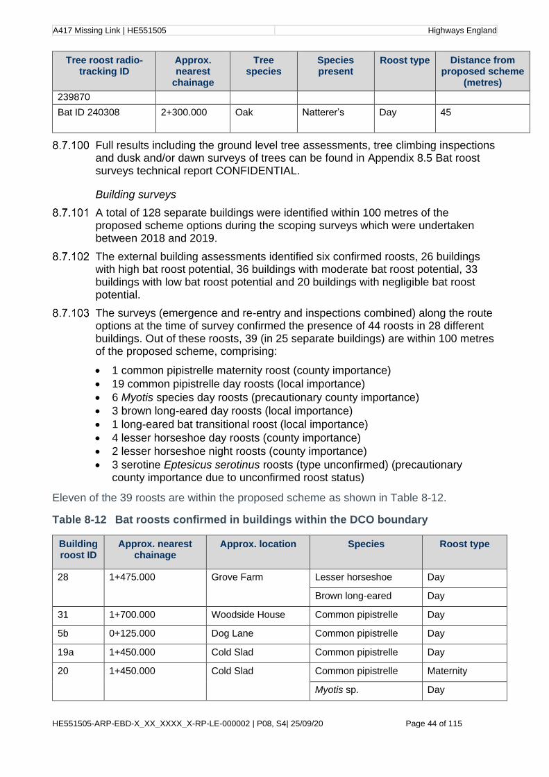
A417 Missing Link | HE551505 Highways England
HE551505-ARP-EBD-X_XX_XXXX_X-RP-LE-000002 | P08, S4| 25/09/20 Page 44 of 115
Tree roost radio-tracking ID
Approx. nearest
chainage
Tree species
Species present
Roost type Distance from proposed scheme
(metres)
239870
Bat ID 240308 2+300.000 Oak
Natterer’s Day 45
Full results including the ground level tree assessments, tree climbing inspections and dusk and/or dawn surveys of trees can be found in Appendix 8.5 Bat roost surveys technical report CONFIDENTIAL.
Building surveys
A total of 128 separate buildings were identified within 100 metres of the proposed scheme options during the scoping surveys which were undertaken between 2018 and 2019.
The external building assessments identified six confirmed roosts, 26 buildings with high bat roost potential, 36 buildings with moderate bat roost potential, 33 buildings with low bat roost potential and 20 buildings with negligible bat roost potential.
The surveys (emergence and re-entry and inspections combined) along the route options at the time of survey confirmed the presence of 44 roosts in 28 different buildings. Out of these roosts, 39 (in 25 separate buildings) are within 100 metres of the proposed scheme, comprising:
• 1 common pipistrelle maternity roost (county importance)
• 19 common pipistrelle day roosts (local importance)
• 6 Myotis species day roosts (precautionary county importance)
• 3 brown long-eared day roosts (local importance)
• 1 long-eared bat transitional roost (local importance)
• 4 lesser horseshoe day roosts (county importance)
• 2 lesser horseshoe night roosts (county importance)
• 3 serotine Eptesicus serotinus roosts (type unconfirmed) (precautionary county importance due to unconfirmed roost status)
Eleven of the 39 roosts are within the proposed scheme as shown in Table 8-12.
Table 8-12 Bat roosts confirmed in buildings within the DCO boundary
Building roost ID
Approx. nearest chainage
Approx. location Species Roost type
28 1+475.000 Grove Farm Lesser horseshoe Day
Brown long-eared Day
31 1+700.000 Woodside House Common pipistrelle Day
5b 0+125.000 Dog Lane Common pipistrelle Day
19a 1+450.000 Cold Slad Common pipistrelle Day
20
1+450.000
Cold Slad
Common pipistrelle Maternity
Myotis sp. Day
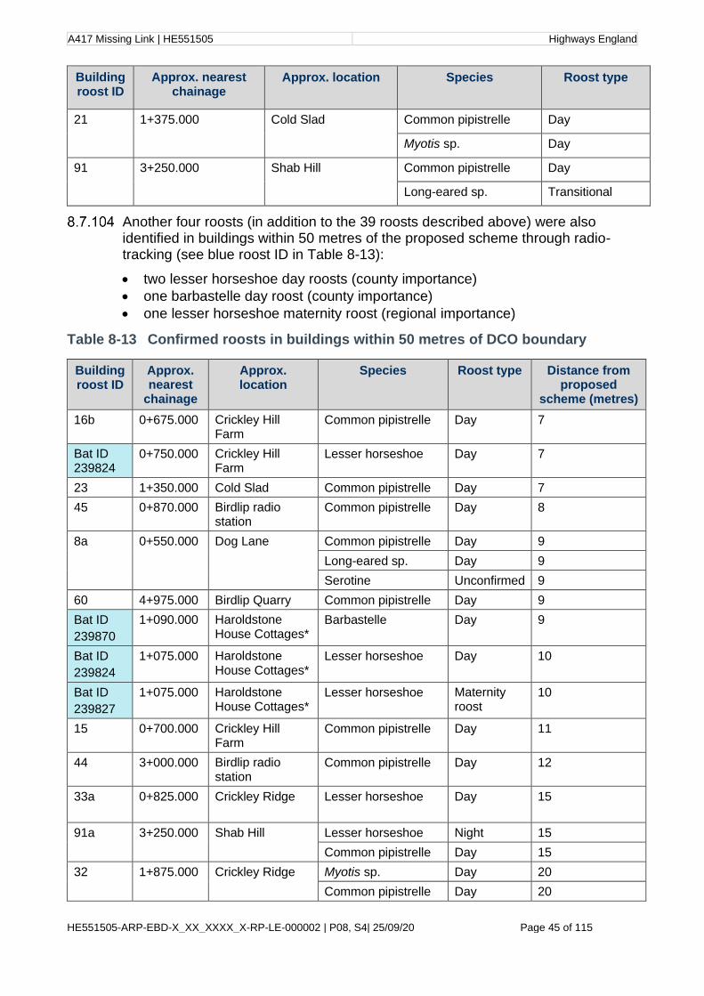
A417 Missing Link | HE551505 Highways England
HE551505-ARP-EBD-X_XX_XXXX_X-RP-LE-000002 | P08, S4| 25/09/20 Page 45 of 115
Building roost ID
Approx. nearest chainage
Approx. location Species Roost type
21
1+375.000
Cold Slad
Common pipistrelle Day
Myotis sp. Day
91
3+250.000 Shab Hill
Common pipistrelle Day
Long-eared sp. Transitional
Another four roosts (in addition to the 39 roosts described above) were also identified in buildings within 50 metres of the proposed scheme through radio-tracking (see blue roost ID in Table 8-13):
• two lesser horseshoe day roosts (county importance)
• one barbastelle day roost (county importance)
• one lesser horseshoe maternity roost (regional importance)
Table 8-13 Confirmed roosts in buildings within 50 metres of DCO boundary
Building roost ID
Approx. nearest
chainage
Approx. location
Species Roost type Distance from proposed
scheme (metres)
16b 0+675.000 Crickley Hill Farm
Common pipistrelle Day 7
Bat ID 239824
0+750.000 Crickley Hill Farm
Lesser horseshoe Day 7
23 1+350.000 Cold Slad Common pipistrelle Day 7
45 0+870.000 Birdlip radio station
Common pipistrelle Day 8
8a
0+550.000
Dog Lane
Common pipistrelle Day 9
Long-eared sp. Day 9
Serotine Unconfirmed 9
60 4+975.000 Birdlip Quarry Common pipistrelle Day 9
Bat ID
239870
1+090.000 Haroldstone House Cottages*
Barbastelle Day 9
Bat ID
239824
1+075.000 Haroldstone House Cottages*
Lesser horseshoe Day 10
Bat ID
239827
1+075.000 Haroldstone House Cottages*
Lesser horseshoe Maternity roost
10
15 0+700.000 Crickley Hill Farm
Common pipistrelle Day 11
44 3+000.000 Birdlip radio station
Common pipistrelle Day 12
33a 0+825.000
Crickley Ridge Lesser horseshoe Day 15
91a
3+250.000
Shab Hill
Lesser horseshoe Night 15
Common pipistrelle Day 15
32
1+875.000
Crickley Ridge Myotis sp. Day 20
Common pipistrelle Day 20
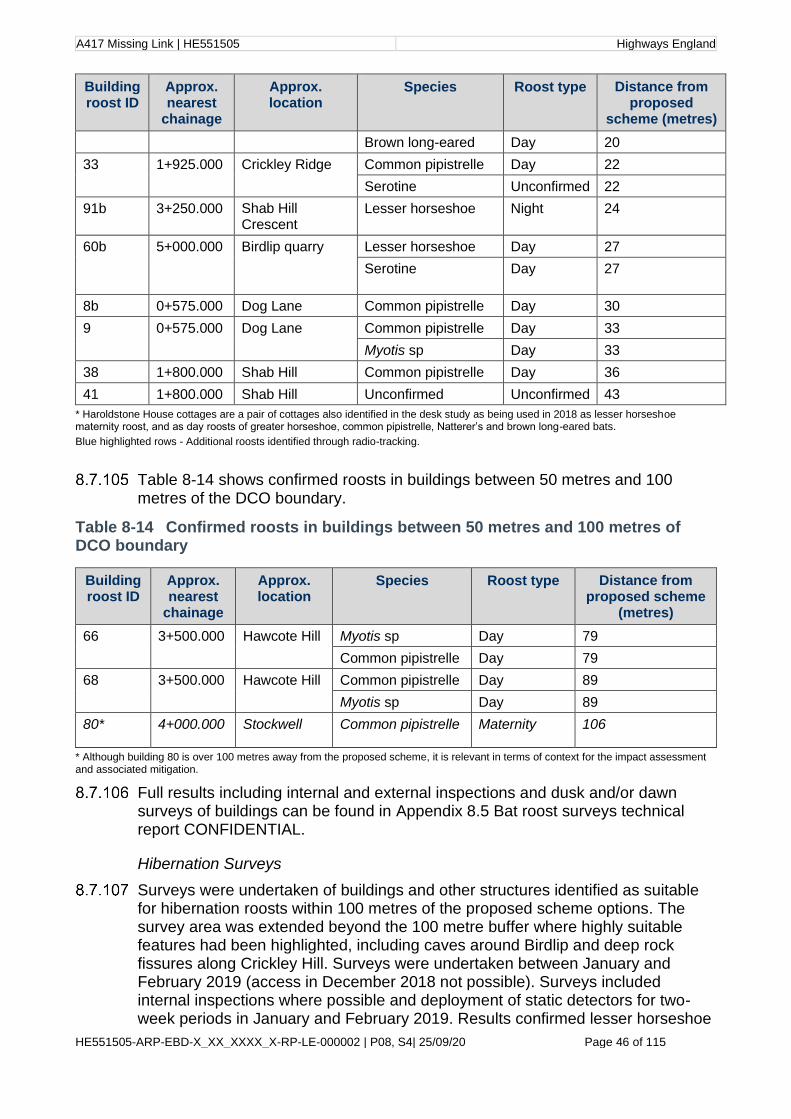
A417 Missing Link | HE551505 Highways England
HE551505-ARP-EBD-X_XX_XXXX_X-RP-LE-000002 | P08, S4| 25/09/20 Page 46 of 115
Building roost ID
Approx. nearest
chainage
Approx. location
Species Roost type Distance from proposed
scheme (metres)
Brown long-eared Day 20
33
1+925.000
Crickley Ridge Common pipistrelle Day 22
Serotine Unconfirmed 22
91b 3+250.000 Shab Hill Crescent
Lesser horseshoe Night 24
60b
5+000.000
Birdlip quarry
Lesser horseshoe Day 27
Serotine Day 27
8b 0+575.000 Dog Lane Common pipistrelle Day 30
9 0+575.000 Dog Lane Common pipistrelle Day 33
Myotis sp Day 33
38 1+800.000 Shab Hill Common pipistrelle Day 36
41 1+800.000 Shab Hill Unconfirmed Unconfirmed 43
* Haroldstone House cottages are a pair of cottages also identified in the desk study as being used in 2018 as lesser horseshoe maternity roost, and as day roosts of greater horseshoe, common pipistrelle, Natterer’s and brown long-eared bats.
Blue highlighted rows - Additional roosts identified through radio-tracking.
Table 8-14 shows confirmed roosts in buildings between 50 metres and 100 metres of the DCO boundary.
Table 8-14 Confirmed roosts in buildings between 50 metres and 100 metres of DCO boundary
Building roost ID
Approx. nearest
chainage
Approx. location
Species Roost type Distance from proposed scheme
(metres)
66
3+500.000
Hawcote Hill
Myotis sp Day 79
Common pipistrelle Day 79
68 3+500.000
Hawcote Hill
Common pipistrelle Day 89
Myotis sp Day 89
80* 4+000.000 Stockwell Common pipistrelle Maternity 106
* Although building 80 is over 100 metres away from the proposed scheme, it is relevant in terms of context for the impact assessment and associated mitigation.
Full results including internal and external inspections and dusk and/or dawn surveys of buildings can be found in Appendix 8.5 Bat roost surveys technical report CONFIDENTIAL.
Hibernation Surveys
Surveys were undertaken of buildings and other structures identified as suitable for hibernation roosts within 100 metres of the proposed scheme options. The survey area was extended beyond the 100 metre buffer where highly suitable features had been highlighted, including caves around Birdlip and deep rock fissures along Crickley Hill. Surveys were undertaken between January and February 2019 (access in December 2018 not possible). Surveys included internal inspections where possible and deployment of static detectors for two-week periods in January and February 2019. Results confirmed lesser horseshoe

A417 Missing Link | HE551505 Highways England
HE551505-ARP-EBD-X_XX_XXXX_X-RP-LE-000002 | P08, S4| 25/09/20 Page 47 of 115
bats hibernating in Crickley Hill rock fissures (numbers not known) and indicated the likely presence of a serotine hibernation roost at this location. Lesser horseshoe bats were also confirmed hibernating within the Birdlip Royal George Cave (maximum count of 13 lesser horseshoes, with more bats likely to be present in inaccessible areas), which is also likely to be used as a hibernation roost by Myotis species.
Full results can be found in Appendix 8.5 Bat roost surveys technical report CONFIDENTIAL.
Bat activity transect surveys and automated detector surveys
Bat activity surveys have confirmed the presence of at least 11 species of bat within and around the footprint of the proposed scheme: common pipistrelle, soprano pipistrelle (Pipistrellus pygmaeus), Nathusius’ pipistrelle (Pipistrellus nathusii), serotine, barbastelle, Myotis species, noctule (Nyctalus noctula), Leisler’s (Nyctalus leisleri), long-eared Plecotus sp., greater horseshoe and lesser horseshoe.
The majority of bats recorded both during transects and static surveys were common pipistrelle, with high activity levels recorded across the majority of the site for this species. Key areas of activity identified during the transect surveys included along the convergence of a number of linear features along the track to the north-east of Birdlip Radio station, with the second highest levels of activity south of Crickley Hill along the lane to Cold Slad.
Transect and static surveys confirmed the presence of Annex II bat species including lesser horseshoe, greater horseshoe and barbastelle, as well as potential for Bechstein’s due to the recording of Myotis species and availability of suitable habitat for this species. Of these species, lesser horseshoe was the most frequently recorded across the proposed scheme, with moderate to high levels of activity recorded at a number of static locations including 1A and 1B (Birdlip Quarry area), 2B (Stockwell), 3C (Ullen Wood), 4B and 4Ca (Crickley Hill Farm/Fly Up), 6B (between Hawcote Hill and Stockwell), 7A and 7B (Crickley Hill). Activity for the other Annex II species was generally low; however, percentile activity levels for greater horseshoe were in the moderate band for sites 4B, 4Ca (Crickley Hill Farm area) and 6B (between Hawcote Hill and Stockwell).
Full results including bat activity maps can be found in Appendix 8.6 Bat activity survey report.
Bat crossing point surveys
A summary of the bat crossing point findings can be found in Table 8-15.
Table 8-15 Bat crossing point survey results summary
Crossing point survey location
Chainage Description and location Total bats crossing using feature
1 4+725.000 A narrow unlit lane with an avenue of trees. Bordered on all sides by agricultural fields which are used for grazing livestock. Located north of Birdlip Quarry.
120
2 4+025.000 Narrow, unlit lane bordered by a dry-stone wall and semi-mature trees. To the south is a large farm known as Stockwell Farm.
98

A417 Missing Link | HE551505 Highways England
HE551505-ARP-EBD-X_XX_XXXX_X-RP-LE-000002 | P08, S4| 25/09/20 Page 48 of 115
Crossing point survey location
Chainage Description and location Total bats crossing using feature
3 3+600.000 Mature hedgerow between arable fields used for grazing- Located c.200m east of CP1. To the north-east is a belt of woodland.
31
4 3+940.000 Semi-circular belt of mature broadleaved woodland between fields. Located c.200m north of CP3. To the west of the site is an area of woodland known as Cally Hill Plantation.
60
5 2+925.000 Mature conifer treeline c.12m tall, between fields. To the south of the site is Cally Hill planation woodland.
112
6 2+825.000 Section of hedgerow and scrub which is connected to a small area of woodland. The hedgerow splits two grass fields and is surrounded on all aspects by agricultural fields. To the east is Ullen Wood.
54
7 2+800.000 Pocket of semi-mature woodland -Triangular shaped and comprises of young broadleaved woodland, connected to CP5 and CP6. The western terminal end of the woodland is connected to Ullen Wood.
131
The number of commuting bats seen by surveyors at each survey location and the overall levels of bat activity varied considerably according to the nature of the feature being surveyed and the quality of the commuting and foraging habitat for bats in the immediate surroundings.
Common pipistrelle bats were observed at every crossing point location and were the most recorded species at all survey locations. Generally, the flight height for this species fluctuated; however, a correlation between flight height and the height of the vegetation along the feature was observed at some crossing point locations. For instance, CP5 and CP7 recorded the highest number of safe bat passes and both CP5 and CP7 comprise mature trees which were above 5 metres in height. Whereas at CP1 almost all bat passes were recorded at an unsafe flight height, and at this location the avenue of trees along the feature were immature and less than 5 metres tall.
CP5, CP6, and CP7 between Shab Hill and Ullen Wood are all ecologically connected features that produced high levels of bat activity from a diverse species composition. Lesser horseshoe bats, which are listed as an Annex II species were recorded more times at CP6 than at any other location. Additionally, this species was recorded on every survey visit, suggesting that this feature is flight route for this species used year-round.
Full results can be found in Appendix 8.7 Bat crossing point survey report.
Bat trapping and radio-tracking surveys
A total of 253 bats were captured at 12 trapping sites in July and September 2019, and May 2020 combined. In July 2019, 60 bats were captured consisting of 11 species. In September 2019, 106 bats were captured of ten species. However, the latter survey session included the trapping of bats at a swarming site, which

A417 Missing Link | HE551505 Highways England
HE551505-ARP-EBD-X_XX_XXXX_X-RP-LE-000002 | P08, S4| 25/09/20 Page 49 of 115
alone recorded 58 bats over two nights of survey. In May 2020, 87 bats were captured of 10 species, including 28 bats from the same swarming site/cave trapped in September 2019.
The proportions of some bats differed between surveys sessions. In July, the greatest proportions of captures were from brown long-eared bats (25%), Brandt’s bat (Myotis brandtii) (20%) and whiskered bat (Myotis mystacinus) (18%). However, in September 2019 and May 2020 these proportions had reduced and other species such as Natterer’s and Daubenton’s (M. daubentonii) were captured more frequently. The Annex II species proportions were slightly different over the three survey sessions. Over twice the number of Bechstein’s were captured in September compared to July 2019 and May 2020, and greater horseshoe bat were not recorded in July 2019. No barbastelles were captured in May 2020. Lesser horseshoe bats were regularly captured during all three survey sessions and were the most consistently recorded of the Annex II species.
The sex ratio of the bats captured and those selected for radio-tracking was male dominated. The general area appears to be important for males of Annex II species and this is supported by consistent captures of Bechstein’s and barbastelle bats on both the July and September 2019 survey sessions. The capture of the male greater horseshoe in September, and regular captures of male lesser horseshoe on both 2019 surveys, also highlights the potential mating and transitional (pre-hibernation) role of the survey area to these bat populations. In May 2020 breeding (pregnant) greater horseshoe bats were also captured at a cave roost near Birdlip.
The combination of woodland and subterranean (cave) habitats in the area, is likely to provide an important resource for these species and other species such as Myotis and long-eared bats where swarming behaviour at such sites is key part of the mating cycle (Parsons, Jones, Davidson-Watts and Greenaway, 200376).
Although breeding noctule and common pipistrelle bats were captured during the breeding season (July), they numbered only one bat of each species, which did not indicate the presence of a local breeding population. Breeding lesser horseshoe and brown long-eared bats were frequently captured indicating the presence of local breeding population(s). The lesser horseshoe was tagged and subsequently located roosting in the Crickley Hill area confirming a maternity roost relatively close to the proposed scheme. The most significant finding of the May 2020 session was the capture, tagging and confirmation of breeding/pregnant greater horseshoe bats near Birdlip.
A total of 23 bats were fitted with radio transmitters during the July (7 bats) and September (9 bats) 2019, and May (7 bats) 2020 survey sessions. The majority of these bats (18) were Annex II species, with five Bechstein’s (all males), eight lesser horseshoe bats, two barbastelles and three greater horseshoe bat tracked throughout the night to obtain movement data. In addition, three Natterer’s (one in each survey session) and two Daubenton’s (September 2019 and May 2020) were tagged for roost finding purposes.
The radio-tracking analysis and the core area determination showed high use of part of the proposed scheme area. The road corridor area west of the Air Balloon roundabout supported multiple crossing points for tagged Annex II species over the existing A417 between the Crickley Hill woodland areas and the woodland/pasture habitats to the south. The current mature tree/woodland

A417 Missing Link | HE551505 Highways England
HE551505-ARP-EBD-X_XX_XXXX_X-RP-LE-000002 | P08, S4| 25/09/20 Page 50 of 115
vegetation is likely to assist bats in crossing the existing road, in particular around the area east of the Fly Up bike park/Dog Lane. There was also a high level of foraging/flying behaviour immediately to the north and south of the existing road corridor, which was also likely to be related to the presence of the woodland habitats in this area.
There was less east west flying behaviour, with only one lesser horseshoe travelling from Ullen Wood to the Crickley Hill area. One Bechstein’s also travelled from Crickley Hill to the Colesbourne across the A417 to the east; however, this bat never returned to the study area during the tracking subsequently undertaken.
The bats captured in the Ullen Wood complex and other trappings sites to east of the A417 generally remained in the area and did not cross this part of the proposed scheme area.
A total of 27 roosts were recorded for all bats tagged during July and September 2019, and May 2020. The majority of roost sites (15) were confirmed in trees or located in woodland where access was not possible (and therefore assumed to be a tree roost through triangulation). The remainder of roosts (10) were located in buildings including houses and agricultural buildings and two roosts were located in underground sites (cave and an old mine). Most of these roosts are outside of the DCO boundary (those located within 100 metres are included in Table 8-10 to Table 8-14).
Full results can be found in Appendix 8.8 Bat advanced survey technical report CONFIDENTIAL.
In conclusion, taking the presence of all four Annex II species, the current status and presence of roost sites, including the maternity population of lesser horseshoe bats, is it considered that the assemblage of bats in the area of the A417 at Birdlip are of national importance.
Badger
Desk study
Five badger records were returned within 1.2 miles (2 kilometres) of the route options in the 2017 desk study. Three records of badger were provided in the updated 2019 desk study. Two of these records are of road casualties on the A417 in June and August of 2019 approximately 500 metres to the west of the proposed scheme. The other is approximately 1.2 miles (2 kilometres) south of the proposed scheme at Elkstone.
Four main areas of badger activity and associated setts were identified during the 2006 WPS Stage 2 assessment77, at Crickley Hill; Barrow Wake; Ullen Wood and Nettleton Bottom.
Field surveys
During the 2017 Phase 1 survey, a single badger outlier sett was recorded. Incidental findings of badger activity were also recorded during the Stage 2 ecology surveys in 2018. Targeted badger walkover surveys were undertaken (where access allowed) during January and February 2019 within 500 metres of the preferred route corridor. During these surveys 106 setts were recorded including five active main setts within 500 metres of the proposed scheme. The

A417 Missing Link | HE551505 Highways England
HE551505-ARP-EBD-X_XX_XXXX_X-RP-LE-000002 | P08, S4| 25/09/20 Page 51 of 115
main areas of activity recorded in 2019 corresponds to the areas of activity identified during previous surveys undertaken in 2006.
Badger bait marking surveys of the five active main setts were undertaken in March and April 2019 to identify the territories of each badger clan. These surveys confirmed badger activity within the study area. Fresh latrines were found for each sett and within each territory throughout the survey period. Based on the results from the bait marking surveys, the proposed scheme severs three of the four territories in the following locations; at Dog Lane to the west of the proposed scheme (already severed by current A417), Shab Hill in the centre of the proposed scheme and the quarry at the south-eastern extent of the proposed scheme.
As stated in the limitations, Emma’s Grove woodland has not been fully surveyed for the presence of badger setts due to access constraints. The woodland has been accessed by public footpath and surrounding hedgerows have been accessed but no evidence of badger activity was recorded, however the woodland and surrounding fields offer suitable habitat for badgers. A badger survey is proposed when access is permitted.
Badgers are considered to be of local importance within the context of the local area.
Further details on the results including maps showing the various territories can be found in Appendix 8.9 Badger survey report CONFIDENTIAL.
Birds
Desk study
The 2006 Stage 2 assessments identified a range of common breeding birds, nine Red List Species of High Conservation Concern and 14 Amber List Species of Medium Conservation Concern. It also identified records of barn owl within Ullen Wood (possible breeding roosts), and within two mature oaks in other areas of the site (nest sites).
The 2017 desk study identified a range of breeding birds within the study area including a number of Red and Amber listed species of conservation concern and Schedule 1 species including barn owl. The 2019 desk study included one record of a barn owl over the A417 in Bentham; one record of a barn owl just off the A417 in Brimpsfield and one record of a barn owl hunting near a road verge in Brockworth, all recorded in 2017.
Field surveys
Breeding birds
A total of six surveys were carried out between April and June 2019. The arable fields and their margins were found to hold in places a high density of breeding territories of seed-eating species including skylark (Alauda arvensis), linnet (Linaria cannabina) and yellowhammer (Emberiza citronella). Woodlands and other areas with trees were found to hold species of conservation concern such as marsh tit (Poecile palustris), spotted flycatcher (Muscicapa striata), song thrush (Turdus philomelos), mistle thrush (Turdus viscivorus) and bullfinch (Pyrrhula pyrrhula).

A417 Missing Link | HE551505 Highways England
HE551505-ARP-EBD-X_XX_XXXX_X-RP-LE-000002 | P08, S4| 25/09/20 Page 52 of 115
The breeding bird surveys undertaken across 2019 showed a breeding population of birds comprising a number of Red and Amber Listed species, which together are considered to be of county importance.
Further details on the results, including figures, can be found in Appendix 8.10 Breeding bird technical report.
Wintering birds
A total of six surveys were undertaken between October 2018 and February 2019. Key areas highlighted from the surveys included the Shab Hill area and arable land, notably to the south-east. The surveys indicated good numbers of wintering birds including (as maximum counts recorded on site across the survey area) 18 yellowhammer (BTO Red List78), 184 common gull (Larus canus) (BTO Amber List), 178 golden plover (Pluvialis apricaria), 72 lapwing (Vanellus vanellus) (BTO Red List), 557 fieldfare (Turdus pilaris) (BTO Red List) and 412 redwing (Turdus iliacus) (BTO Red List).
The wintering bird surveys undertaken across 2019/2020 showed a wintering population of birds comprising a number of Red and Amber Listed species, which together are considered to be of county importance.
Further details on the results, including figures, can be found in Appendix 8.11 Wintering bird survey report.
Barn owl
Stage 1 and 2 habitat and potential nest identification surveys within 0.9 miles (1.5 kilometres) of the DCO boundary were completed in May 2019. Large areas of suitable type 1 and 2 habitat were noted at Shab Hill, Fly Up bike park and Crickley Hill/Bentham area. Evidence of barn owl roosts was found at Fly Up bike park and Little Witcombe. Over 50 Potential Nest Sites (PNS) were noted across the proposed scheme. Stage 3 nest verification surveys subsequently took place in July and August 2019.
Thirty-five PNS were surveyed in the Stage 3 surveys. This was through a mixture of ground-level inspections, inspections using ladders, and/or dusk emergence surveys. Eight of these PNS were then considered to be suitable for breeding barn owls although none showed signs of current breeding. Evidence of barn owls roosting (through the presence of pellets) was found at seven PNS. Barn owl foraging activity was observed at two locations in the area close to Shab Hill.
During Stage 1 and 2 habitat surveys ARS and TRS where also recorded; of which one ARS was recorded within 100 metres and two TRS were recorded within 500 metres.
Barn owl is a Schedule 1 species and is susceptible to sharp population declines as a result of factors including harsh weather, low prey availability and habitat loss and fragmentation. The surveys undertaken in 2019 provide evidence of at least three breeding pairs of barn owls within 500 metres of the DCO boundary, which is considered to be of county importance.
Further details on the results, including figures, can be found in Appendix 8.12 Stage 1 and 2 Barn Owl survey report CONFIDENTIAL, Appendix 8.13 Stage 3 Barn Owl survey report CONFIDENTIAL and Figures 8.15 to 8.19.

A417 Missing Link | HE551505 Highways England
HE551505-ARP-EBD-X_XX_XXXX_X-RP-LE-000002 | P08, S4| 25/09/20 Page 53 of 115
Dormouse
Desk study
No records of dormouse were returned in the 2017 desk study or in the 2019 update within 2km of the proposed scheme. However, the National Dormouse Database (People’s Trust for Endangered Species) provides a record approximately 2.6km north of the scheme from 2017.
Field surveys
Suitable habitat for dormice is present at the site including broadleaved woodland and species rich hedgerows. Much of the broadleaved woodland at the site generally has poor understorey, which is not optimal for dormice, but the woodland margins provide diverse structure and species diversity offering more suitable habitat. A number of areas of mixed plantation woodland provide suitable habitat as well as a network of hedgerows providing valuable linking habitat to the wider landscape.
Habitats suitable for dormouse (identified during the Phase 1 Habitat survey and a desktop study) were subject to presence/absence surveys using nest tubes during 2018 and 2019. Thirteen sites in total were surveyed, with 50 or more tubes deployed at each site. No dormice were identified during these surveys. Nest tubes at 5 sites contained some fresh leaves but no woven structures identifiable as a dormouse nest. The surveyed sites included Ullen Wood at the north of the survey area which is partially connected to Emma’s Grove woodland with bramble scrub along a stock fenceline. Whilst Emma’s Grove was not surveyed for dormice due to access constraints, its small extent, fairly isolated position and the absence of dormice from adjacent surveyed habitats infer that it is unlikely to support a viable population of dormice.
Although a dormice record has been provided 2km north of the scheme, dormice were not recorded in the two most northerly and largest woodland areas within the survey area, Crickley Hill and Ullen Wood. Based on survey results dormice are not considered to be present within the ZoI of the proposed scheme and are not assessed further. Landscaping designs have however taken account of dormouse preferred habitat to enable dispersal of the European Protected Species across the wider landscape in the future.
Further details on the results, including figures, can be found in Appendix 8.14 Dormouse survey report.
Great crested newt
Desk study
The 2006 Stage 2 Assessment undertook detailed surveys of three ponds. No evidence of great crested newt was identified during these surveys.
Four records of great crested newt were returned in the 2017 desk study. Twenty-five additional records were provided in the updated 2019 desk study from GCER. One record of a female great crested newt was returned from a cellar in Brimpsfield approximately 0.6 miles (1 kilometre) south-west of the southern extent of the proposed scheme. Twenty-four records were submitted under a Natural England Mitigation licence for great crested newt from a residential area in Bentham approximately 150 metres east of the most western section of the
A417 Missing Link | HE551505 Highways England
HE551505-ARP-EBD-X_XX_XXXX_X-RP-LE-000002 | P08, S4| 25/09/20 Page 54 of 115
DCO boundary but approximately 370 metres north of the existing A417. The great crested newt report associated with these records is available on the Tewsbury Borough Council website79. As well as the ponds within Bentham Green Space stated above, the report indicates a small pond at the end of a drainage channel with a great crested newt population which is within the DCO boundary. The report concludes a medium meta population of great crested newt are located within ponds at Bentham Green Space to the north of the current A417. These ponds were not surveyed in relation to this application as surveys were being carried out by another consultancy in 2019.
A further pond within a golf course at National Star College falls within 500 m of the scheme due to a DCO boundary alteration. This pond has not yet been assessed though this is proposed for September 2020. It is known that this pond is a fishing lake so is likely to be sub optimal habitat for great crested newts. Results of habitat suitability assessment and any further surveys required will be reported in the Environmental Statement.
Field surveys
Thirty-three waterbodies were identified within 500 metres of the proposed scheme. HSI assessments were undertaken on 21 of these water bodies that were considered as suitable habitat to support great crested newts in May 2018. Waterbodies such as swimming pools or those that were dry were excluded. Sixteen ponds were further surveyed for the presence of great created newts using eDNA in June 2018 and May 2019. Three ponds returned a positive eDNA result. Pond 15 in Birdlip and Pond 2a on the western edge of Crickley Hill fall within 500 metres of the proposed scheme. Pond 26a at Birdlip also returned a positive eDNA result. This pond was included due to proximity to the scheme options but is over 500 metres from the current proposed scheme.
Great crested newt are a European Protected Species, however south Gloucestershire is a strong hold for great crested newt and they are widespread across the county; therefore, in the context of the proposed scheme, great crested newt are considered to be of county importance.
Further details on the results, including figures, can be found in Appendix 8.15 Great crested newt survey report.
Reptiles
Desk study
The 2006 Stage 2 Assessment identified populations of common lizard (Zootoca vivipara) and slow worm (Anguis fragilis) at two sites within the study area.
The 2017 desk study returned records of all four common species of reptile; common lizard, slow worm, adder (Vipera berus) and grass snake (Natrix Helvetica) within 1.2 miles (2 kilometers) of the proposed scheme. The updated desk study from 2019 returned 191 records of reptiles. Adder, slow worm and common lizard were all recorded at Crickley Hill and Barrow Wake SSSI in 2019. Eighty-one records of adder were provided from Crickley Hill and Barrow Wake SSSI in 2019. These records were of both males and females. Eleven records of common lizard, 58 records of slow worm and 18 records of grass snake were returned from Crickley Hill and Barrow Wake SSSI. Common lizard and slow worm records were returned from within Birdlip Quarry within the DCO boundary.

A417 Missing Link | HE551505 Highways England
HE551505-ARP-EBD-X_XX_XXXX_X-RP-LE-000002 | P08, S4| 25/09/20 Page 55 of 115
Field surveys
All habitats within 100 meters of the proposed scheme were assessed for their suitability to support reptiles. Fifty sites were originally identified during the desk study as requiring further assessment.
During the Phase 1 habitat survey, 22 reptile surveys sites were identified within 100 metres of either side of the route options at the time of survey in 2018. Of the 22 sites assessed, seven were considered to be of high potential, 11 medium potential and three low potential to support reptiles. Eighteen sites, those with medium or high potential to support reptiles, were subject to an initial seven survey visits to determine presence or likely absence. Following these initial surveys, the number of surveys was extended to 20 visits to provide a more accurate estimate of population size where presence of reptiles had been confirmed. Surveys were undertaken in suitable weather conditions between June and October 2018 and March to September 2019. SGARG continued to survey a site at Crickley Hill during 2019.
Due to local records for adder and incidental sightings during the ecology surveys during 2018 and presence during the 2019 survey season, ten adder survey sites were set up in March 2019, targeting areas of high-quality habitat, to gain a greater understanding of the adder population
Reptiles were identified at 17 of 18 sites surveyed across the length of the proposed scheme. All four common reptile species; adder, grass snake, slow worm and common lizard were recorded at four of the survey sites; within and to the north of the quarry (sites eight and six respectively), the SGARG site at Crickley Hill and land adjacent to Dog Lane (site 41) at the western extent of the proposed scheme. Ten of the 18 survey sites support good populations of reptiles with exceptional populations of slow worms recorded at the SGARG site at Crickley Hill and site 47, a grassland field south-west of Air Balloon roundabout. Adders were found at eight of the survey sites with a good population recorded at the SGARG site.
An anecdotal sighting of an adder at hedgerow 18 south-west of Shab Hill was also recorded during hedgerow surveys in 2019.
Based on guidance from Froglife, each site was assessed to evaluate its importance for reptiles. Eight of the 18 survey sites are important or key sites for reptiles80. Therefore, the assemblages of reptiles within the DCO boundary are of county importance.
Further details on the results, including figures, can be found in Appendix 8.16 Reptile survey technical report.
Otter
Desk study
No signs of otter were identified during the 2006 Stage 2 assessment. A single otter record, a road casualty from 2015 was identified in the 2017 desk study from a residential garden near Horsbere Brook approximately 800 meters south-west of the site. The updated 2019 desk study included one record of an otter sighting at Horsbere Brook approximately 1.1 miles (1.85 kilometres) from the proposed scheme and two reports of otter feeding signs in Brockworth.
A417 Missing Link | HE551505 Highways England
HE551505-ARP-EBD-X_XX_XXXX_X-RP-LE-000002 | P08, S4| 25/09/20 Page 56 of 115
The desk study and conversations with Gloucester Wildlife Trust confirmed that otters are present in the area and known to use Horsbere Brook, the northern section of Norman’s Brook, the Upper Frome, all of which are part of the River Severn Catchment, and the River Churn which is part of the River Thames catchment.
Field surveys
Where access allowed, habitat suitability and field sign surveys for otter were undertaken within 1.2 miles (2 kilometres) of the proposed scheme options in 2018 and 2019. An unnamed tributary of the River Frome located in Brimpsfield Park was surveyed in July and August 2019 and May 2019. Presence of otter was confirmed by the presence of spraint, footprints and potential holts.
Horsbere Brook, running through Little Witcombe, was surveyed in September 2018 and May 2019. Norman’s Brook was surveyed to the north and south of the A417 in August and September 2018 and May 2019. The ephemeral stream Coldwell Bottom was surveyed in July 2019. No evidence of otter was recorded along any of these watercourses.
Otters are a European Protected Species. They are considered to be of county importance.
Further details on the results, including figures, can be found in Appendix 8.17 Otter technical report.
Water vole
Desk study
No signs of water vole were identified during the 2006 Stage 2 assessment. No records of water vole were returned in the 2017 desk study, or in the 2019 update.
Field survey
Where access allowed, habitat suitability and field sign surveys for water voles was undertaken along watercourses within 250 metres of options 30 and 12 in 2018. Possible but inconclusive evidence of water vole (outside of the 250 metre buffer) were found in Brimpsfield Park. Field surveys carried out in August 2018 and May 2019 recorded no evidence of water vole along Norman’s Brook or the River Frome.
Water vole are considered to be absent from the ZoI of the proposed scheme and therefore are not taken forward for assessment.
Further details on the results, including figures, can be found in Appendix 8.18 Water vole technical report.
White-clawed crayfish
Desk study
No records for White-Clawed Crayfish (WCC) were returned within 1.2 miles (2 kilometres) of the proposed scheme. An extended data search was conducted and records for WCC in the upper catchment of the River Frome (1.9 miles (3 kilometres) south) as well as within Painswick stream (2.5 miles (4 kilometres)

A417 Missing Link | HE551505 Highways England
HE551505-ARP-EBD-X_XX_XXXX_X-RP-LE-000002 | P08, S4| 25/09/20 Page 57 of 115
south-west) of the Cotswolds Beechwoods SAC were returned. In 2019, for the River Churn, the EA commented that “We trapped a site in the waterbody in 2008 and only found signals. We catch signals occasionally in our sampling along there. We are confident that there are no WCC left in the main Churn itself. There are unsubstantiated reports that WCC may exist still within tributaries of the Churn.” Norman’s Brook had no records of WCC returned. No further records were found in the 2019 updated desk study within the ZoI of the proposed scheme.
In 2019 populations of WCC were also identified in communications with the EA outside the ZoI in Climperwell Brook (2 miles (3.2 kilometres) south-west) and Slad Brook (4.5 miles (7.3 kilometres) south-west).
Field survey
The Phase 1 habitat survey conducted during 2017 assessed habitat suitability for WCC for all watercourses that bisected the route options’ corridor. From this, detailed habitat assessments and presence/absence surveys for WCC were undertaken during October 2018 (hand searches and baited trapping) at Norman’s Brook and in the River Frome Upper Tributaries.
WCC were found to be absent at both watercourses during these surveys. Although suitable refugia and habitat was identified at Norman’s Brook, the ephemeral nature of the watercourse reduces the potential to support a viable population and therefore this watercourse is generally considered unsuitable. The survey reaches of the Upper Frome (i.e. those nearest to the proposed scheme) overall had unsuitable habitat. However, in lower reaches further south, suitable habitat with a flow regime more suited to WCC was identified. The presence of signal crayfish (Pacifastacus leniusculus) and crayfish plague limits the viability of populations.
Due to the lack of WCC records and the negative result during field surveys, WCC are presumed absent from the study area and therefore not taken further for assessment.
Further details on the methodology including limitations, results, including figures, can be found in Appendix 8.19 White-clawed crayfish technical report.
Terrestrial invertebrates
Desk study
The data search as part of this assessment returned 93 records of invertebrate species between 2007 and 2016. Records returned included six Schedule 5 butterflies (WCA 1981), 20 SP (listed under NERC Act 2006), nine Red Listed species and five notable species. Locations of records were varied but locations with larger number of records included: Crickley Hill, Barrow Wake, Groveridge Banks Key Wildlife Site, Groveridge Hill (south of Brimpsfield), Leckhampton Hill SSSI and Westerleigh Cottage (Cowley).
Twenty-five species of insects listed as priority species were returned from the 2019 desk study between 2017 and 2019. These include pretty chalk carpet (Melanthia procellata), buff ermine (Spilosoma lutea) and mottled rustic (Caradrina Morpheus), all recorded within Crickley Hill.

A417 Missing Link | HE551505 Highways England
HE551505-ARP-EBD-X_XX_XXXX_X-RP-LE-000002 | P08, S4| 25/09/20 Page 58 of 115
From the National Trust’s Crickley Hill Report81, a significant diversity of grassland invertebrates including two Red Data Book species, a SPI butterfly (dingy skipper (Erynnis tages), Nationally Scarce snails, beetles, moths and bees, most associated with short-turf herb-rich areas. Veteran beech pollards along the edge of Shortwood Belt support a range of Nationally Scarce wood-decay invertebrates, mostly beetles. The report suggests that Crickley Hill is considered to be at least of Regional importance for wood-decay (saproxylic) invertebrates, primarily beetles but other groups are of interest too. Wood-decay species include a range of Nationally Scarce species. Other species of significant interest include the fever fly (Dilophus bispinosus) for which Crickley Hill is only the seventh known locality in Britain and the fungus gnat (Grzegorzekia bushyae) for which Crickley Hill is only the third known site globally.
An additional invertebrate survey82 on wood-decay invertebrate species focussed on Crickley Hill and The Scrubbs was also undertaken in the 2019 survey season. Three hundred and nine invertebrate species were recorded, with 34 species having a conservation status, including four with British Red List status. Twelve Coleoptera were Nationally Scarce, 16 Diptera were Nationally Scarce and one Nationally Rare. The saproxylic beetle fauna is considered, based upon the Index of Ecological Continuity, to be of national importance.
Roman snails and aquatic macroinvertebrates are considered in separate sections.
Field survey
Across the surveyed sites in 2019 and 2020, a number of scarce and rare species were recorded. In summary, three Red Data book species, 29 Nationally Scarce species and five SPI were recorded.
The most productive sites for scarce invertebrates are considered to be Sites 1- Birdlip Quarry, 5 -Short Wood, 6-Crickely Hill, 7- West of Crickley Hill and 10 – Barrow Wake; all of which are of county Importance for their invertebrate fauna. Site 9 is noteworthy as it is the only site with the Red Data Book species of fly (Oxyna nebulosior) or the Nationally Scarce bee (Hyaleus signatus).
Crickley Hill and Barrow Wake SSSI within its citation includes a number of species recorded from field surveys, including: cistus forester moth (Adscita Geryon) and chalkhill blue (Lysandra coridon).
The terrestrial invertebrate surveys undertaken in 2019 and 2020 showed an assemblage of terrestrial invertebrates comprising a number of notable species. The invertebrate assemblage within the proposed scheme is considered overall to be of county importance, however Crickley Hill is considered to be of national importance based upon the invertebrate reports (2015, 2019) specifically due to saproxylic beetle fauna.
Further details on the results, including figures and site locations, can be found in Appendix 8.20 Terrestrial invertebrate survey report.
Roman snail
Desk study
The 2017 data search as part of this assessment returned two records for Roman snail. One originates from Ullenwood (2016) 503 metres north and one from

A417 Missing Link | HE551505 Highways England
HE551505-ARP-EBD-X_XX_XXXX_X-RP-LE-000002 | P08, S4| 25/09/20 Page 59 of 115
Witcombe Wood (2009) 954 metres west of the proposed scheme. The 2019 data search as part of this assessment returned an additional four records for Roman snail. One originates from within the proposed scheme adjacent to Dog Lane (2019) and is for 6 – 20 snails found on a footpath to Crickley Hill (June 2019) and another is also for 6 - 20 snails on the A417 road verge in the vicinity of Grove Farm (2018). One originates from within the proposed scheme in proximity to the Birdlip Quarry (disused) (2019) and one from woodland at Leckhampton Hill (2019) approximately 1.4 miles (2.2 kilometres) north.
Field survey
Roman snail has been identified in two discrete locations within the proposed scheme during the 2019 surveys. Adults, juveniles and shells were found at Location 1 (Cold Slad Lane, north of the A417) and a juvenile and a juvenile shell at Location 2 (the Birdlip Quarry (disused)). Incidental records of Roman snail/shells have also been identified in 2018 and 2019 at Location 1 and during the invertebrate survey on the 04 June 2020, twenty-one live specimens of roman snail were recorded on the lower section of the invertebrate Site 7 at the western extent of Crickley Hill. Shells were found to the south of the A417 near Grove Farm in addition to within the Crickley Hill SSSI.
Further details on the results can be found in Appendix 8.21 Roman snail survey report 2019 and in Figures 8.13 and 8.14.
Roman snail is listed as a species of conservation concern by IUCN (least concern) and is rare in Gloucestershire83 and the population(s) present within the proposed scheme are of local importance.
Aquatic invertebrates
Desk study
The data search returned invertebrate biological records and associated biological indices from ten Environment Agency monitoring sites between 2000 and 2019. Three of the monitoring sites were located within the wider river network but are not hydrologically connected to the proposed scheme. A further seven sites outside of the wider river network but with hydrological connectivity to waterbodies within the study area were selected on the basis that they were the closest to the proposed scheme. These sites provide further understanding of the baseline invertebrate communities present in watercourses influenced by the proposed scheme.
Thirteen invertebrate species of conservation value were identified. All invertebrate species of conservation importance were recorded on the River Churn and/or the River Frome. No invertebrate species of conservation value were recorded in Norman’s Brook
No Invasive Non-Native Species (INNS) were found on the River Churn or Norman’s Brook. In the River Frome, the INNS signal crayfish (Pacifastacus leniusculus) (Schedule 9 of the Wildlife and Countryside Act) was recorded.
No species of conservation importance or INNS were reported to have been recorded on Painswick Stream during the desk study.
A417 Missing Link | HE551505 Highways England
HE551505-ARP-EBD-X_XX_XXXX_X-RP-LE-000002 | P08, S4| 25/09/20 Page 60 of 115
Field study
Across the seven survey sites the Community Conservation Indicator (CCI) scores varied between low and very-high reflecting high variability in the conservation value of taxa present between the sites.
In Norman’s Brook CCI scores varied between moderate and very high. Three nationally notable invertebrate species were recorded; the net-spinning caddisfly (Hydropsyche fulvipes), the Northern caddisfly (Rhyacophila fasciata) and the riffle beetle (Riolus subviolaceus).
WHPTASPT and WHPTNTAXA values obtained from sites within Norman’s Brook are indicative of moderate to good levels of diversity and proportions of taxa which are sensitive to general degradation.
In the River Frome CCI scores varied between moderate and fairly high. No invertebrate species of conservation value were recorded, and no INNS were recorded.
WHPTASPT and WHPTNTAXA values obtained from sites within River Frome suggested low diversity and low proportions of taxa which are sensitive to general degradation. The site AQ4 returned WFD status classification of bad and poor for spring and autumn seasons, providing further evidence for an impaired invertebrate community.
In the River Churn CCI scores varied between moderate and fairly high. The nationally notable Northern caddisfly was recorded, and the INNS signal crayfish was also recorded.
WHPTASPT and WHPTNTAXA values obtained from sites within the River Churn are indicative of moderate to good levels of diversity and proportions of taxa which are sensitive to general degradation. The site AQ6 returned WFD status classification of moderate for spring and autumn seasons, suggesting a moderate deviation from the invertebrate community expected to be present at this site in pristine conditions.
Further details on the limitations of this study and results; including biological indices can be found in Appendix 8.22 Aquatic invertebrate survey report and in Figures 8.20 and 8.21.
In conclusion, taking the community level conservation value present at the sites and the presence of three notable species, it is considered that the macroinvertebrate communities in the area of the A417 are of local importance.
Fish habitat assessment
Desk study
The data search as part of this assessment returned 80 records between 2000 to 2019 from 21 EA monitoring sites. No EA monitoring sites were identified to fall within the proposed scheme. As a result, the closest sites to the proposed scheme and hydrologically connected waterbodies were selected.
Records of 17 fish species were provided from EA monitoring sites; four of which are of conservation importance - brown trout (Salmo trutta), European eel, European bullhead (Cottus gobio) and lamprey species (brook lamprey Lampetra planeri and lamprey sp. ammocoetes).
A417 Missing Link | HE551505 Highways England
HE551505-ARP-EBD-X_XX_XXXX_X-RP-LE-000002 | P08, S4| 25/09/20 Page 61 of 115
Records of brown trout were returned from Painswick stream, the River Frome, and Horsbere Brook. Records of European eel were returned from Painswick stream, River Frome, Horsbere Brook and Hatherley Brook. Records of bullhead and lamprey were reported on the River Frome. No records of species of conservation importance were returned for the River Churn or Norman’s Brook.
Field study
Fish habitat assessments were carried out in October 2019 and January 2020 at six reaches within the proposed scheme (Norman Brook) and in close proximity (Horsbere Brook and tributaries of the River Churn and River Frome).
Normans Brook upstream of the A417 (Site 1) and downstream of the A417 (Site 2) were considered to provide suitable habitat for brown trout, juvenile lamprey, European eel and bullhead. However, a number of significant barriers, notably the existing A417 culvert and numerous other obstructions to fish passage downstream were recorded and the watercourse is therefore considered disconnected to the wider catchment. There is there is potential for Normans’ Brook to support an isolated population of brown trout, bullhead and brook lamprey. European eel has the potential to be present if able to surpass the barriers to migration identified.
Horsbere Brook, near Little Witcombe (Site 3) had large portions river of unsuitable for fish as was culverted. Despite this, some areas habitat meeting the requirements for salmonid parr and fry life stages were identified. Adult habitat was absent.
The surveyed section of an unnamed tributary of River Churn, near Coberley (Site 4) was predominantly unsuitable for fish sue to insufficient water depth, however a small amount of mixed juvenile (parr/fry) habitat was recorded. No barriers to fish passage were identified at this site.
The surveyed section of an unnamed tributary of River Churn, near Colwell Bottom (Site 5) and an unnamed tributary of the River Frome Site 6 (River Frome) were both highly fragmented by impassable weirs, barriers and culverts. Nevertheless, there is potential for the reach to support isolated populations of brown trout and bullhead.
Further details on the results can be found in Appendix 8.23 Fish habitat assessment report and in Figures 8.5 to 8.12.
Fish habitats identified during 2019 and 2020 surveys within the proposed scheme were found to be impacted by habitat fragmentation, hydrological fluctuations and anthropogenic changes. Fish habitats within the proposed scheme are of local importance.
Other section 41 Species of Principal Importance (SPI)
The 2017 – 2019 data search as part of this assessment returned four records of hedgehog (Erinaceus europaeus) within 1.2 miles (2 kilometres) of the DCO boundary. Records are from Brockworth, Witcombe and Cowley with the nearest record being approximately 0.6 miles (1 kilometre) south-west of the western extent of the proposed scheme. The data search returned one record of common toad (Bufo bufo) over 0.6 miles (1 kilometre) from the proposed scheme in Cowley. The habitat within the DCO boundary is suitable for these species and

A417 Missing Link | HE551505 Highways England
HE551505-ARP-EBD-X_XX_XXXX_X-RP-LE-000002 | P08, S4| 25/09/20 Page 62 of 115
other species potentially present such as harvest mouse (Micromys minutus), brown hare (Lepus europaeus) and polecat (Mustela putorius).
Populations of Section 41 species are considered to be of local importance.
Future baseline
As set out in Chapter 4 Environmental assessment methodology, the ‘Do Minimum’ and ‘Do Something’ scenarios have been set out, with the ‘Do Minimum’ scenario representing the future baseline with minimal interventions and without new infrastructure.
The ecological baseline conditions described above represent those which currently exist in the absence of the proposed scheme and at the time of writing. As stated in section 3 of the CIEEM guidelines84, potential changes in baseline conditions also need to be identified in order to assess impacts.
Based on the above information and current land use, the future baseline in the absence of the proposed scheme is unlikely to change significantly by 2040. Subtle changes are expected due to climate change, such as some movements of certain species and local population changes; however, the overall habitats and species composition in the study area are expected to be broadly similar to that of the existing baseline. Therefore, the future baseline would remain the same as set out in the existing baseline.
8.8 Potential impacts
A highway scheme can impact biodiversity in a number of ways during construction and operation.
The potential impacts to habitats and species could be permanent or temporary, and direct or indirect. The direct impacts are of habitat loss and severance, species mortality through vehicle collisions, disturbance due to noise, habitat degradation due to changes in air quality, dust deposition, surface run-off and pollution events. Indirect effects could include displaced individuals or the occupancy of alternative habitat, including reduced foraging success, increased competition and predation, genetic isolation and inbreeding, which can lead to local extinctions. It is possible that there would be indirect impacts of the proposed scheme due to hydrological changes affecting other habitats and areas of vegetation.
Habitat loss
Habitats would be lost through the change of land use from countryside (predominantly farmland and some woodland) to highway. In particular, a small section of broadleaved woodland at Emma’s Grove which supports a number of ancient woodland indicator species, although is shown not to be ancient on historical mapping, would be permanently lost as the north of the site falls within the DCO boundary. Habitat loss within the highway boundary would be permanent, whereas some areas that would be used as compounds and borrow pits during construction would be temporary, with the habitat reinstated or in most cases enhanced post-construction. Haul routes would be within the highway and are not anticipated to result in additional permanent or temporary habitat loss. Small satellite compounds required at each overbridge structure are proposed to be within existing highway with the exception of compounds required for the Gloucestershire Way crossing and the Cotswold Way crossing.

A417 Missing Link | HE551505 Highways England
HE551505-ARP-EBD-X_XX_XXXX_X-RP-LE-000002 | P08, S4| 25/09/20 Page 63 of 115
Works are anticipated within the Barrow Wake unit of the Crickley Hill and Barrow Wake SSSI as a result of the widening of the A417, the detrunking of the existing A417 road and the creation of a roundabout at Barrow Wake on the B4070 access road between Shab Hill and Birdlip. Works would incur the loss of calcareous grassland and broadleaved trees due to embankment creation and some broadleaved woodland either side of the existing underpass would be lost in the creation of the roundabout adjacent to the entrance of Barrow Wake.
In general, habitat loss, including that which supports protected species in providing breeding, roosting and foraging habitat for example, would be mitigated through creation of replacement habitat and/or enhancement of retained habitat.
The total loss through permanent and temporary land take are shown in Table 8-17 in section 8.10 below. The largest areas of habitat loss are improved grassland, poor semi-improved grassland, arable land and semi-natural broadleaved woodland.
Habitat severance
The proposed scheme would run through open countryside, and the habitat severance between habitats and the populations of animals they support north and south of the road is likely to have significant effects on species populations in the area. The road would likely sever existing wildlife corridors and foraging areas for wildlife.
Severance of habitat can lead to isolation both within and between populations and from specific resources vital for survival. The indirect effects of this could include reduced foraging success, increased competition, genetic isolation and inbreeding, which can lead to local extinctions.
The new road alignment could create a barrier to species movements and dispersal across the landscape. As such, habitat severance, isolation and restrictions to movements of species would be mitigated through the provision of multispecies crossings (in the form of overbridges, underpasses and culverts), with fencing to ensure their safe crossing. This would retain connectivity for wildlife between habitats severed by the proposed scheme, thus reducing any severance and isolation effects.
Habitat severance would also occur during site clearance and construction, but these effects can be reduced through the sensitive programming of construction activities. For example, in bat sensitive areas, the vegetation clearance and planting schedules can be tailored to ensure the avoidance of disturbance during the bat active season, between May to September, and a minimum time lag between clearance and replanting. Such severance effects can be further reduced through dead hedging, for example, which can provide temporary habitat connectivity across key commuting routes and during sensitive bat activity periods.
Habitat damage or degradation
Habitats within or adjacent to the proposed scheme, or those that are hydrologically connected to it, are sensitive to effects from both construction and operation, such as pollution events from, dust, fuel and chemical spills, from change in vehicle emissions, and from sediment run-off. Whilst best practice construction and operation design for pollution prevention and control would be

A417 Missing Link | HE551505 Highways England
HE551505-ARP-EBD-X_XX_XXXX_X-RP-LE-000002 | P08, S4| 25/09/20 Page 64 of 115
used, there is always a risk during construction and operation from vehicles and the transporting of potentially polluting materials.
Dust deposition due to demolition, earthworks and construction have the potential to affect sensitive habitats and plant communities such as ancient woodland at Ullen Wood and calcareous grassland at the Barrow Wake unit of Barrow Wake and Crickley Hill SSSI. Material crushing in particular can be a significant source of dust associated with the construction phase. Dust can directly affect vegetation by smothering, reducing ability to photosynthesise and respire. Dust leached into soils can affect the chemical composition of the soil and therefore plant health or plant communities. Indirect changes may occur as a result of increased susceptibility to disease and air pollution85. Dust deposition could have an indirect on fauna, as the quality or suitability of foraging habitat is reduced. These changes are likely to occur only as a result of long-term construction works adjacent to a sensitive habitat. Often impacts would be reversible once the works are completed, and dust emissions cease.
Groundwater-dependent terrestrial ecosystems, such as wetland habitats found at Bushley Muzzard SSSI, could be affected by local hydrological changes. Further details can be found within Chapter 13 Road drainage and the water environment. Ground water modelling is to be completed to enable full assessment of any impacts on habitat within the SSSI as a result of changes to ground water recharge.
Elevated oxides of nitrogen (NOx) concentrations are generally considered to be the main threat to vegetation from vehicle emissions. More details on air quality impacts can be found in Chapter 5 Air quality.
Disturbance
Impacts from visual disturbance (including human activity and artificial lighting) and noise disturbance could have significant effects on sensitive species. This could lead to abandonment of territory or of young, increased predation risk and use of critical energy reserves.
Disturbance resulting from lighting can also lead to significant effects on nocturnal species such as bats. The effect of road lighting is complex and varies for different species, but includes roost disturbance and abandonment, severance and loss of foraging and commuting habitats, and a decline in airborne invertebrate prey.
Species mortality and injury
Species mortality or injury can occur during construction as well as operation of highways. Less mobile species, or animals that are hibernating or have young, are likely to be most vulnerable to direct mortality during vegetation clearance and construction.
The effects of individual mortality can lead to local extinctions once a population falls below a critical threshold. These effects are often greatest within longer-lived species, with greater parental investment and low annual reproduction, which struggle to recover from loss of family or population members.
Animals that are particularly at threat of local extinction include fish, and aquatic macroinvertebrates due to their juvenile or reproductive stages being within watercourses which are directly within the proposed scheme or the ZoI.

A417 Missing Link | HE551505 Highways England
HE551505-ARP-EBD-X_XX_XXXX_X-RP-LE-000002 | P08, S4| 25/09/20 Page 65 of 115
Many animals are killed by vehicle collision on UK roads each year and this is likely to be the case for the proposed scheme in the absence of mitigation in the form of wildlife crossings either under or over the road and wildlife fencing.
Animals that are particularly susceptible and are at risk from collision are badger, otter and bats due to the severance of wildlife corridors, and birds, especially barn owl, due to the way in which they hunt.
8.9 Design, mitigation and enhancement measures
The mitigation hierarchy is described in Chapter 4 Environmental assessment methodology Table 4.4 of the PEI report. The first stage of the mitigation hierarchy is to seek engineering design to avoid or eliminate any potential impacts and adverse effects on biodiversity features as described in Section 8.8. Impacts can be avoided for instance, through changes to the horizontal or vertical alignment of the proposed scheme, junction strategy, structures or other aspects of the proposed scheme layout; or through changes in the timing, methods and/or materials to be used in construction. This is referred to as embedded mitigation. Where it is not possible to avoid an impact entirely, the design should seek to reduce the magnitude of the impact and provide essential mitigation.
The proposed scheme assessed within this PEI report includes a number of engineering design measures that have been incorporated to avoid significant adverse environmental effects arising, such as habitat loss, habitat fragmentation, habitat degradation and species disturbance and mortality, where practical.
These measures have been identified and developed through the design process, including consultation with stakeholders and statutory bodies. These measures form part of the proposed scheme design and are described within PEI report Chapter 2, The project.
The proposed scheme also includes embedded mitigation within working practices during the construction phase of the proposed scheme which would avoid or reduce impacts such as with habitat loss, habitat severance, habitat damage, disturbance and species mortality.
Enhancement measures have also been included, going above and beyond what is required to mitigate the adverse effects of the proposed scheme.
The following sections outline these measures and how they would reduce the impact of the proposed scheme on biodiversity. Details will be provided in the Environmental Masterplan (Figure 7.9) and will be provided in a Landscape and Ecological Management Plan (LEMP) which will be provided as part of the Environmental Management Plan (EMP) submitted with the ES.
Embedded design mitigation
In terms of ecology the design of the proposed scheme aims to primarily avoid or reduce the impacts of habitat loss, habitat degradation, habitat fragmentation and species mortality.
Through the embedded design and mitigation proposals, the proposed scheme is aiming for an increase in wildlife habitat quality and species of flora and fauna compared to the baseline.
Details on all embedded design measures relevant to Biodiversity including underpasses, mammal culverts, overbridges and other specific mitigation for bats
A417 Missing Link | HE551505 Highways England
HE551505-ARP-EBD-X_XX_XXXX_X-RP-LE-000002 | P08, S4| 25/09/20 Page 66 of 115
and badgers is discussed in Chapter 2, Table 2.4- Proposed structures and section 2.7.6, and will be referred to throughout this assessment.
Embedded construction mitigation
Embedded mitigation during the construction phase will be identified in the Register of Environmental Actions and Commitments (REAC), contained within the Environmental Management Plan (EMP). This will be developed to avoid or reduce the potential construction impacts on habitats and species and will seek to employ best-practice methods for dealing with habitat loss, habitat severance, disturbance and species mortality.
The EMP will include specific construction phase method statements that will address potential impacts on habitats and species and will detail the timing of works, roles and responsibilities of the contractors, control measures, training and briefing procedures, risk assessments and monitoring systems to be employed during planning and construction for all relevant environmental factor areas.
The EMP will include site-specific methods, for example silt busters or bales would be used to prevent silt or contaminants from being released into watercourses such as Norman’s Brook. Such precautions will be undertaken in accordance with relevant legislation and undertaken in compliance with the relevant Guidance for Pollution Prevention (GPPs) and industry best practice (GPP586, CIRIA).
The EMP to be submitted with the ES will include site specific measures to protect sensitive habitats such as Ullen Wood ancient woodland, from dust deposition caused by activities such as material crushing. Measures will include:
• location of the material crushing compound over 200 metres from Ullen Wood ancient woodland and sensitive orientation of the crusher within the compound area;
• water sprinkler systems to be used whenever there is a risk of dust emissions; screening bunds or barriers;
• no material crushing in high prevailing winds in the direction of the ancient woodland; and
• removal of materials from site as soon as possible.
Additional mitigation to protect ancient woodland habitat would include a buffer zone of at least 15 metres between the works and the woodland edge in accordance with Natural England guidelines where possible. There is one location at the north western tip of Ullen wood adjacent to the A436 where this buffer has not been achieved. A buffer of at least 3 metres between construction areas and hedgerows would also be implemented to protect the root zones of hedges and maintain edge habitat for the benefit of wildlife. Such protection measures required will be included in Annex D of the EMP, to be submitted with the ES.
The root zones and canopies of scattered trees, woodland and hedgerows to be retained would be protected during construction. Measures for protection will be included in the EMP and will refer to root protection zones stated in Appendix 7.3 Arboricultural impact assessment. It is acknowledged that some overhanging branches from Ullen Wood to the A436 could require pruning in order to protect trees from accidental damage by construction machinery. Such works would be carried out by suitably experienced arboriculturalists to maintain health of the trees.

A417 Missing Link | HE551505 Highways England
HE551505-ARP-EBD-X_XX_XXXX_X-RP-LE-000002 | P08, S4| 25/09/20 Page 67 of 115
Protected and notable species
It is anticipated that the effects of disturbance or risk of mortality to species during construction would be mitigated through specific construction phase method statements detailing best practice that would address potential impacts on species and prevent committing offences in relation to the Wildlife and Countryside Act, 1981 (as amended). General best practice measures that address multiple ecological receptors are detailed below. Essential mitigation for particular species, such as fencing and translocation in the case of reptiles are provided in the essential mitigation section.
A pre-construction check for Schedule 9 listed invasive plant species both terrestrial and aquatic would be undertaken at the appropriate time of year to inform and requirement to avoid or remove invasive species.
The implementation of biosecurity best practice described as ‘check, clean, dry’ would help to mitigate any potential mobilisation of invasive aquatic plant species and also chytrid fungus which effects amphibians. Measures for dealing with invasive species and implementing biosecurity measures will be incorporated in Annex D of the EMP.
Construction activities could result in individual birds and/or their active nests being injured/killed and/or destroyed, respectively. For this reason, vegetation clearance would be planned to be undertaken between September and February outside of the core breeding bird season, which is considered as March-August, inclusive. If this is not possible and works are required within this period, vegetation clearance works would adopt a precautionary working method including nesting bird surveys to identify nesting birds within 24 hours of the commencement of clearance, and a watching brief by a suitably experienced ecologist during all vegetation clearance where visibility (for nest detection) is limited on the pre-works surveys. If nesting birds are encountered, a suitable working buffer distance from the nest would be devised, by a suitably experienced ecologist, and the nest left until all young have fledged.
Sensitive programming of construction works would be implemented to avoid or reduce potential impacts such as mortality or disturbance to species. Details will be incorporated in Annex D of the Environmental Management Plan (EMP) and include:
• sensitive timing of works involving Norman’s Brook realignment regarding aquatic macroinvertebrates and fish translocation;
• sensitive timing and methodologies of vegetation clearance and manipulation regard to nesting birds and other species such as reptiles and amphibians to be overseen by a suitably experienced ecologist; and
• avoidance of ground works in key reptile habitat or Roman snail habitat between November and March to prevent harm to hibernating animals.
Restrictions on working hours to avoid night working (taken as the period 30 minutes before sunset to 30 minutes after sunrise) would be implemented so that there is no light spill in the vicinity of watercourses and key bat flight lines or roosts and adjacent habitats. Any temporary task lighting required would be directional lighting and designed to ensure no light spill over 0.5 Lux on any identified bat commuting and foraging areas or roosting habitat or water courses with regard to bats and otters. Lighting restrictions will be detailed in the EMP.

A417 Missing Link | HE551505 Highways England
HE551505-ARP-EBD-X_XX_XXXX_X-RP-LE-000002 | P08, S4| 25/09/20 Page 68 of 115
Lighting designed to be sensitive to bats and otters, would also benefit other nocturnal wildlife such as owls and badgers.
All excavations would be closed overnight, or ramps provided to reduce risk of trapping or injuring wildlife.
Essential mitigation
Essential mitigation would be implemented in order to mitigate for the potential impacts as described within Section 8.8 that cannot be avoided within the embedded mitigation through design or construction working practices.
Veteran trees
Of the 22 veteran trees identified within or adjacent to the DCO boundary Table 8-16 shows the trees that are lost to the proposed scheme or those that may be impacted in areas of temporary land take or adjacent to the DCO boundary such as impacts to rootzones or overhanging canopy.
Table 8-16 Veteran trees potentially impacted due to construction
Tree Reference
Species Grid Reference
Location Location within DCO boundary
Impact
Arboricultural Survey
T57 Sycamore – pollard
394366 214532
South of Shab Hill In area of permanent land take
Lost under main alignment
T67 Ash 394661 215041
East of Shab Hill In area of temporary landtake for drainage
Retain and protect.
T90 Ash 393422 214661
East of Air Balloon Way (woodland spur)
In area of temporary landtake for drainage
Retain and protect
T108 Ash 393993 214821
Hedgerow Tree south of Shab Hill
Adjacent to earthworks
Retain if possible and protect
T171 Hawthorn 393423 216136
Air Balloon Cottages
Adjacent Protect root zone and canopy
T172 Beech 393405 216114
Air Balloon Cottages
Adjacent Protect root zone and canopy
T174 Beech 392985 215893
Cold Slad Lane In area of temporary landtake for drainage
Protect root zone and canopy
T190 Oak 392468 215646
Fly up bike park Adjacent Protect root zone and canopy
T205 Sycamore 392208 215833
Dog Lane, (north side)
Adjacent Protect root zone and canopy
T126 Beech 393509 216067
Adjacent to Emma’s Grove
In area or permanent land take
Lost under main alignment

A417 Missing Link | HE551505 Highways England
HE551505-ARP-EBD-X_XX_XXXX_X-RP-LE-000002 | P08, S4| 25/09/20 Page 69 of 115
Tree Reference
Species Grid Reference
Location Location within DCO boundary
Impact
T127 Beech 393579 216116
Adjacent to Emma’s Grove
In area or permanent land take
Lost under main alignment
Woodland Trust records
143975 duplicate T67
Ash 394669 215039
East of Shab Hill In area of temporary landtake for drainage
Retain and protect
143988 Ash pollard 394663 215043
East of Shab Hill In area of temporary landtake for drainage
Retain and protect
155073 Orchard apple
393468 216101
Air balloon public house
Within drainage earthworks area
Retain and protect, or translocate
196380 Beech 394538 214492
Stockwell Farm hedgerow
In area or permanent land take
Lost under main alignment
Four trees would be lost due to construction of the proposed scheme. A further five are within temporary land take areas with permissive access for drainage and therefore, it is possible these trees may be retained. Five trees are adjacent to the DCO boundary and would require protection, including of root and canopy extents. A further eight trees listed as being within or adjacent to the DCO boundary are in areas of retained vegetation and would not be impacted by the construction works. Trees that can be retained would be protected in accordance with the British Standards BS 2837:2012. Measures for protection will be further detailed in the EMP and will include reference to root protection zones stated in the Arboricultural Impact Assessment report. Both documents will be provided with the ES.
The veteran tree in the Air Balloon pub garden may now be retained within the detailed landscape design for the drainage basins in this location. Further work on earthworks levels is required to secure this opportunity. If it is not possible to retain the tree, it would be assessed for its suitability for translocation to a suitable area within close proximity to its existing location, potentially at the entrance to the proposed Cotswold Way crossing or within planting adjacent to Emma’s Grove woodland.
Another tree marked as notable, but not veteran is a wych elm in a hedgerow within an area of temporary landtake to be used as the material crusher and Gloucestershire Way crossing compound. This tree should be protected and retained within the compound area.
Woodland and scattered trees
Semi-natural broadleaved woodland accounts for the majority of woodland to be lost especially woodland along the verges and embankments of the existing A417 from Brockworth to Air Balloon roundabout and also loss of beech woodland and mixed broadleaved woodland at Shab Hill. Some mature woodland comprising predominantly ash and hazel coppice would also be lost at the northern tip of Emma’s Grove woodland.
New broadleaved woodland species of native variety characteristic of existing woodland would be planted along the southern verge of the new A417 from Brockworth to the Crickley Hill area to replace woodland lost during construction to ensure continuity of woodland habitat along this section of the proposed

A417 Missing Link | HE551505 Highways England
HE551505-ARP-EBD-X_XX_XXXX_X-RP-LE-000002 | P08, S4| 25/09/20 Page 70 of 115
scheme. Woodland planting is also proposed in a field bordering Ullen Wood which would provide a woodland edge buffer for the ancient woodland. Similarly, additional trees and scrub would be planted around the edge of Emma’s Grove to create a tiered buffer of vegetation including hazel scrub and small trees. Established hazel stands within Emma’s Grove which would be lost would be coppiced at the appropriate time of the year and translocated to other areas of the woodland to be retained or within the new woodland scrub buffer. Planting new woodland and scrub either adjacent to existing high value habitat such as Ullen Wood or where woodland is lost or fragmented would provide valuable edge habitat to protect the core areas of woodland from variable environmental factors and stresses such as varied light conditions increased wind exposure and pollution. The diverse species mix and structure of edge habitat provides a transition between two habitat types, usually woodland and grassland, and therefore supports a wider array of species. Planting of edge habitat would maximise biodiversity delivery and increase the resilience of existing woodland to climate change.
Species selection for new planting would include a diverse mix of native trees of local provenance and characteristic of the local area to ensure woodlands are resilient to climate change. Where appropriate, the use of non-native species would be considered to provide resilience against the effects of climate change. No ash would be replanted due to the spread of ash die-back disease, however, species would be selected that offer similar habitat for lichens and invertebrates, have similar pollen and nectar production or provide similar food resource. No one species can replace all the characteristics of ash but using aspen, alder, field maple, disease resistant elm, sycamore, oak, hazel and rowan in the landscape planting would provide many of the habitat niches87. Woodland planting is shown on the Environmental Masterplan (Figure 7.9).
Scattered trees and lines of trees are found throughout the study area generally within grassland fields and along minor roads. Historic maps show areas of likely wood pasture which some of these trees could be relics of, such as at the south eastern corner of Crickley Hill. Specimen trees would be planted within a meadow south of Ullen Wood to create wood pasture habitat. Lines of trees would be recreated in the location of Cowley and Stockwell overbridges and scattered trees would be included along the road verges of the Air Balloon Way.
The root zones and canopies of scattered trees to be retained would be protected during construction. Measures for protection will be included in the EMP and include reference to root protection zones stated in the Arboricultural Impact Assessment report which will be provided with the ES. Replanting of specimen trees and trees within hedgerows will be detailed in the EMP to be provided with the ES.
Grassland
As shown in Table 8-17 the majority of grassland recorded within the ZoI of the proposed scheme is poor semi-improved grassland managed largely as low intensity grazing land. Smaller areas of species-rich semi- improved neutral grassland also exist within the study area some of which has relic areas of calcareous grassland that has been lost due to lack of appropriate management. Unimproved and semi improved calcareous grassland is present in the Crickley Hill and Barrow Wake SSSI and several fields to the west of the Air Balloon pub were recorded as semi-improved calcareous grassland managed as horse grazed

A417 Missing Link | HE551505 Highways England
HE551505-ARP-EBD-X_XX_XXXX_X-RP-LE-000002 | P08, S4| 25/09/20 Page 71 of 115
pasture. The most notable area of marshy grassland is present at Bushley Muzzard SSSI approximately 185 metres west of the proposed scheme.
The most notable grassland habitat within the proposed scheme is calcareous grassland and some areas of neutral species-rich meadows. All grassland habitat creation would seek to replace these habitats. Grassland verges of the existing A417 to be repurposed to a WCH route would be widened to create species-rich calcareous grassland. Seeds of native and local provenance would be used, and species chosen which are beneficial for pollinators and other notable invertebrates present in the area. Substrate would be created using excavated material and no imported topsoil would be required.
An area of approximately 0.07ha of calcareous grassland at the northern extent of Barrow Wake SSSI would be lost, both permanently and temporarily, due to construction of the cutting slope for the widening of the A417 and a drainage cascade. Top-soil would be saved from this location and stored separately to retain the seedbank so that it can be spread back onto areas within the SSSI to be reinstated. A field of high botanical value known to contain an abundance of orchids and assessed as NVC community MG5a was recorded to the north of Shab Hill. It is proposed that either the turf is translocated or the top-soil containing the seed bank from this field would be stored and retained in order to use it in areas of habitat creation within the proposed scheme. Receptor site locations for translocated turf or top-soil will be shown on the final EMP Figure 7.9 and methodologies will be included in Annex D of the EMP both to be submitted with the ES.
Hedgerows
Hedgerow surveys identified 12 species-rich hedges within 50 metres of the proposed scheme. Ten of these are classified as important hedgerows under the criteria of the Hedgerows Act and an additional three hedgerows qualify as important due to features other than biodiversity.
The proposed scheme impacts 27 of the 34 hedges surveyed with many of these being lost entirely. In total approximately 3,078 linear metres of hedgerows would be lost, of the overall 5,644 metres within the DCO boundary, including 1,550 metres of important hedgerow.
Sections of hedgerows of particular importance and species richness that would be lost (Hedges 1, 2, 9,17,20, 21, 22, 29) would be assessed and coppiced where suitable prior to the commencement of construction and translocated to other areas of the proposed scheme where hedgerow planting is planned or to in-fill gaps in defunct hedgerows to improve habitat connectivity and mitigate for habitat loss. As part of this process the soil containing hedgerow ground flora would also be translocated. Details of translocation methods will be detailed in Annex D of the EMP.
New hedgerows with standard trees would be planted along much of the eastern section of the proposed scheme and would connect areas of woodland or existing habitat where possible to mitigate hedgerow loss and habitat fragmentation. Newly planted hedgerows would be species-rich comprising a mix of at least seven woody native species of local provenance and in keeping with species recorded in the area. Planting would also include species such as hazel and honeysuckle to provide food and nesting resource for dormice which are known to be present in the wider area. Where land is not required for construction of the

A417 Missing Link | HE551505 Highways England
HE551505-ARP-EBD-X_XX_XXXX_X-RP-LE-000002 | P08, S4| 25/09/20 Page 72 of 115
proposed scheme, hedgerow planting would occur in the first suitable season prior to commencement of works to allow some establishment in advance of habitat loss. New hedgerow planting would total 7,708.05 metres exceeding the amount of hedgerow lost, therefore maximising biodiversity delivery across the proposed scheme.
Areas of potential hedgerow translocation and planting including a species list will be detailed in the Environmental Masterplan to be submitted with the ES.
Bats
In addition to mitigation embedded into design as detailed in Chapter 2, the details of the essential mitigation would be agreed through the licencing process, but a summary of the key measures has been provided below:
• The bat roosts in buildings 28 and 31 and the five roosts in four trees (BAT ID
246245, T33, T163 and T63) identified within the footprint would be removed under mitigation licence obtained from Natural England. Suitable alternative roosting habitat would be provided close to the existing foraging and commuting routes. The exclusion of the roosts would take place at an appropriate time of year when the bats are least vulnerable. The nature and location of the replacement roosts, timing of the exclusion (where appropriate) and timing of the building demolition and tree felling would all be in accordance with the licence method statement which would be developed in consultation with Natural England. Draft Protected Species Licences will be reported and submitted separately from the DCO application, and will be detailed in Annex D of the EMP.
• Pre-construction surveys to be undertaken prior to any tree clearance and demolition of buildings, in particular if more than one year has passed since the last surveys (carried out in 2018/2019), to ensure there are no new bat roost in trees and buildings to be cleared. If any new roosts are identified these would need to be included within the proposed scheme bat mitigation licence and mitigation agreed with Natural England.
• Following pre-construction surveys, any trees where the potential for roosting bats cannot be ruled out after survey would be soft felled. This will be detailed in Annex D of the EMP.
• Provision of a mix of bat boxes on retained trees within the vicinity of roosts likely to be disturbed by construction activity to compensate for disturbance to these roosts.
• Improvements to derelict World War II structure (building 91B, a confirmed night roost of lesser horseshoe bats, will be shown on the final Environmental Masterplan (Figure 7.9) provided with the ES to consolidate its construction and increase its suitability for this Annex II species as well as crevice-dwelling species recorded in the area. This also contributes to addressing disturbance impacts by provide alternative roosting opportunities during construction (re disturbance impacts and loss of roosting opportunities through tree felling).
• Retention of existing roost features where possible, to be strapped to retained mature trees within Highways England ownership as close as possible to their original locations.
• Use of veteranisation techniques to create habitats in younger trees that are otherwise found on older more mature trees.
Any building or tree roosts within 50 metres, depending on type of roost, environmental factors and type of construction activity within the area, could also

A417 Missing Link | HE551505 Highways England
HE551505-ARP-EBD-X_XX_XXXX_X-RP-LE-000002 | P08, S4| 25/09/20 Page 73 of 115
require a disturbance mitigation licence from Natural England and associated method statements drawn up to reduce potential disturbance impacts, such as noise and lighting on these roosts during construction (to be detailed within the EMP).
Key commuting routes for bats would be retained for as long as possible in the works programme. Dead hedges would be used to allow bats to continue using commuting routes, to be detailed within Annex D of the EMP.
If temporary construction lighting is required during the bat activity season, at compound areas for example, or for health and safety requirements, this would consist of directional lighting designed to ensure no light spill over 0.5 Lux on to any identified commuting and foraging areas, as well as roosting habitats. This will be detailed within Annex D of the EMP and secured through the DCO.
Badgers
Badgers have been found to be active across the proposed scheme. In addition to mitigation embedded into design as detailed in Chapter 2, and best working practice the following mitigation for badgers would be undertaken;
• A pre-construction survey for badgers (activity and setts) would be carried out (this will be detailed within Annex D of the EMP).
• No works or tracking of heavy machinery would occur within 30 meters of active badger setts.
• Any active setts to be lost or predicted to be affected as a result of the proposed scheme construction would be closed under a Natural England development licence between the months of July and November prior to commencement of construction. These setts would be determined following the pre-construction survey.
• Loss of main setts would be mitigated for with the provision of alternative setts in suitable habitat within 250 metres of the main sett to be closed under licence from Natural England. This is to be undertaken in advance of the main sett closure. Current survey data indicates that one main sett would require closure at Shab Hill and an artificial sett created.
Breeding birds
The evidence from the 2019 breeding bird surveys indicates that a number of Red and Amber listed breeding species are likely to be within 250 metres of the DCO boundary. Within the survey area breeding birds are supported by a diverse habitat assemblage across the landscape.
Sensitive timing of works including vegetation clearance during site preparation and construction would be implemented as detailed above in the construction mitigation.
Schedule 1 birds were not recorded breeding in the survey area, although three Schedule 1 species were noted during the breeding season in the survey area. Pre-construction surveys for Schedule 1 birds would be undertaken. If Schedule 1 birds (WCA 1981) are found breeding on site or within a distance from the construction work’s footprint and determined to be susceptible to disturbance, then advice should be sought from a suitably qualified ecologist.

A417 Missing Link | HE551505 Highways England
HE551505-ARP-EBD-X_XX_XXXX_X-RP-LE-000002 | P08, S4| 25/09/20 Page 74 of 115
Suitable habitat replacement and creation would begin before construction, e.g. woodland/hedgerow planting, to ensure continuity of breeding habitat provision once displaced during construction.
Nesting bird boxes would be provided for a range of species. Notable species would have nest boxes installed for them, including marsh tit, spotted flycatcher, tawny owl (Strix aluco), kestrel (Falco tinnunculus) and stock dove (Columba oenas). Boxes would be installed prior to the bird nesting season (March-August, inclusive) to provide opportunities for displaced birds (from loss of breeding habitat) to relocate and nest where possible. Where ground-nesting species would lose habitat, e.g. skylark, timing of vegetation would be considered, i.e. no cutting of grassland until birds have fledged.
Details of all mitigation measures including the location of bird boxes will be incorporated within Annex D of the EMP.
Wintering birds
The evidence from the 2018/2019 winter bird surveys indicates that a number of notable winter bird species are likely to be within 250 metres of the DCO boundary.
Within the survey area wintering birds are supported by a diverse habitat assemblage across the landscape including open/arable fields, hedgerows and woodland edge.
Impacts are most likely to arise through potential construction pollution events. Pollution prevention measures will be incorporated within the EMP.
Provision of planting and its management to replace suitable habitat lost due to the proposed scheme will be detailed and incorporated within Annex D of the EMP.
Barn owl
The evidence from baseline surveys and incidental sightings of this species indicate that up to three breeding pairs of barn owls are likely to be present within 500 metres of the DCO boundary in the region of Rushwood Kennels and Stockwell Farm.
In addition to the embedded construction mitigation the following mitigation would be implemented;
• A pre-construction survey for roosting or nesting barn owl would be undertaken in all suitable habitat within 100 metres of the proposed scheme.
• Habitat manipulation techniques would be employed to deter barn owls from entering construction areas, to include mowing long grass to reduce foraging potential.
• Strategic planting of woody species - dense structure planting (to include shrubs and five-year-old trees characteristic of the local area) should be introduced alongside the proposed road, especially at complex junctions such as Shab Hill. Planting height should be at least 3 metres to encourage barn owls to fly over the road at a safe distance above traffic.
• Minimising width of grass verges - width of grass verges across the proposed scheme are 2.5 metres wide along much of the proposed scheme except where larger areas are required for visibility or rock fall catches. Where possible, and especially in high risk barn owl mortality areas the verges would

A417 Missing Link | HE551505 Highways England
HE551505-ARP-EBD-X_XX_XXXX_X-RP-LE-000002 | P08, S4| 25/09/20 Page 75 of 115
be managed to support short calcareous grassland in order to reduce the potential for grass to support barn owl prey species and therefore decrease the foraging potential and collision risks to barn owls.
• An increase in Type 1 barn owl foraging habitat comprising species-rich grassland meadow areas would be created to replace the habitat lost. Locations of grassland habitat creation are proposed to be a previously arable field used as the western compound where barn owl roosts have been identified nearby and grassland currently grazed to the south of Ullen Wood would be managed as a grassland meadow to provide improved foraging resource during the construction and operation of the proposed scheme. This field would be screened from the road with woodland planting which would also seek to provide a commuting route for barn owls to the foraging resource. Locations will be indicated on the final Environmental Masterplan Plan (Figure 7.9) and incorporated within Annex D of the EMP to be submitted with the ES.
Great crested newt
Great crested newts are present in a small pond within the proposed scheme at the far western end in an area identified for drainage works to an existing culvert. This area is currently part of another planning application. It is not considered likely that any works within the pond or vegetation clearance would be required at this location. Broadleaved woodland habitat along the northern road verge of the existing A417 at the western extent of the proposed scheme and along the existing A417 near Birdlip could potentially provide terrestrial habitat for great crested newts present in Pond 2a in the Crickley Hill area, the Bentham ponds and in Pond 15 near Birdlip. However, due to high quality terrestrial habitat surrounding the great crested newt ponds and the presence of minor roads between the ponds and habitat on the site, it is not considered likely that great crested newts would be present within these areas. Woodland habitat in these areas would be retained and protected with the exception of approximately 0.45ha of roadside woodland to the south of Holly Brae property at the western end of the proposed scheme.
A precautionary working method including watching brief by a suitably qualified ecologist would be discussed and agreed with Natural England and could be implemented under a low impact class licence. The method statement will include detail on watching briefs by a suitable experienced ecologist required during works within any terrestrial habitat with potential to be used by great crested newt within 500 metres of the known populations. As an additional precaution, no works in identified suitable great crested newt habitat would be conducted during the hibernation period between November to March inclusive.
Reptiles
Reptiles were identified at 17 locations across the proposed scheme and the presence of the four ‘common’ reptile species together was identified at four of these locations with exceptional numbers of slow worms recorded at Crickley Hill and south-west of Air Balloon roundabout.
Construction activities could result in individual reptiles being injured and/or killed, in the absence of mitigation or suitable working practices. For this reason, a translocation exercise would be carried out encompassing all key reptile areas and areas where adder have been recorded within the proposed scheme prior to the commencement of construction or phased with construction phasing. All

A417 Missing Link | HE551505 Highways England
HE551505-ARP-EBD-X_XX_XXXX_X-RP-LE-000002 | P08, S4| 25/09/20 Page 76 of 115
reptiles found during this exercise would be moved to suitable receptor sites on and off site and previously agreed with relevant landowners. These sites would be areas where the reptile population is already known so that the carrying capacity of the habitat is not exceeded, or new reptile habitat created and established in advance of the translocation. A habitat creation site for reptiles is proposed to the north of the Birdlip Quarry. Retained reptile habitat and new receptor sites, if adjacent to the proposed scheme would be protected with reptile fencing for the duration of the construction phase.
In areas where low number of reptiles were recorded habitat manipulation using phased and directional strimming to displace reptiles to retained habitat would be undertaken in suitable weather and within the reptile active season of April to October prior to construction. This habitat would then be maintained as short grassland to render it unsuitable for reptiles for the duration of the construction phase.
Habitat suitable for reptiles is included in the landscaping of the proposed scheme, including on the Gloucestershire Way crossing and land adjacent to Birdlip quarry which would provide a translocation site. In these locations and in other areas across the proposed scheme habitat mosaics would be created comprising long grassland, scrub, hedgebanks and bare ground with south facing banks for basking and log piles for suitable refuge locations and hibernacula.
These measures will be further detailed in Annex D of the EMP to be provided with the ES.
Otter
Otters were confirmed to be present along the Upper Frome and Horsebere Brook watercourses within the study area, although they are also known to be present in the wider area within the River Churn and northern reaches of Norman’s Brook. No evidence of otter was recorded within the DCO boundary.
A pre-construction survey of all wooded areas adjacent to watercourses within the proposed scheme would be carried out to confirm the presence or absence of any otter holts within the construction area and to inform the requirement for any Natural England mitigation licence required.
Working within 50 metres of a watercourse could cause disturbance to otters. Details of working time restrictions to reduce potential disturbance to dispersing and foraging otter would depend upon the pre-construction surveys and mitigation licence requirements (if required). Any required restriction would be detailed within further iterations of Annex D of the EMP to be provided with the ES.
Terrestrial invertebrates
Notable terrestrial invertebrates are found across the proposed scheme primarily within calcareous grassland and woodland habitat including deadwood and habitat mosaics (including short-sward vegetation, rank grassland, deadwood and scrub).
Construction activities would result in approximately 1.83 hectares of semi improved calcareous grassland and 11.73 hectares of broadleaved semi-natural woodland being permanently or temporarily lost as part of the works under the proposed scheme.
A417 Missing Link | HE551505 Highways England
HE551505-ARP-EBD-X_XX_XXXX_X-RP-LE-000002 | P08, S4| 25/09/20 Page 77 of 115
Mitigation measures would include landscape planting designed to replace that lost and incorporate features beneficial to invertebrates throughout the proposed scheme. Habitat creation would include planting of species-rich grassland with species beneficial to insects including pollinators. Species mixes should seek to include plants that provide a food source for scarce species identified. Habitat creation would include south facing slopes, log piles, deadwood and sheltered areas for invertebrates.
Felled trees should be retained on-site where possible as habitat piles. Deadwood found in areas that are being cleared for the proposed scheme would be moved to suitable areas of retained habitat on site to ensure maintenance of some invertebrate habitat, in particular for wood-decay (saproxylic) invertebrates, e.g. beetles.
A proportion of the re-aligned verges or embankments would also be managed so that areas of bare ground and sparsely vegetated well-drained and calcareous soils are present.
Management and monitoring of the created grassland and woodland habitat and enhancement of retained habitat to ensure its continued suitability for target invertebrate species will be incorporated into Annex D of the EMP.
Roman snail
The presence of Roman snail was identified in two discrete locations and incidental records have also been identified in additional locations.
Construction activities could result in individual Roman snail being crushed, in the absence of mitigation or suitable working practices. For this reason, a translocation exercise would be carried out under Natural England licence encompassing all identified or potential Roman snail habitats likely to be impacted by the proposed scheme or associated works. All Roman snail found during this exercise would be moved to a suitable receptor site. The translocation exercise would be undertaken under a Natural England conservation licence, to be detailed within Annex D of the EMP.
Construction activities would result in confirmed and assumed Roman snail habitat being necessarily lost as part of the works under the proposed scheme. Mitigation measures would include the replacement of an increased area of habitat in areas such as along the existing A417 and in areas designated for habitat creation adjacent to Birdlip Quarry where there are known Roman snail populations. Landscaping would incorporate features beneficial to Roman snail. In addition, enhancement of nearby habitats such as at the southern extent of Haroldstone Fields potential KWS would be undertaken to benefit Roman snail.
All mitigation measures would be included within the Natural England conservation licence and detailed within Annex D of the EMP to be provided with the ES.
Aquatic macroinvertebrates
Direct and indirect impacts on aquatic macroinvertebrates are anticipated within Norman’s Brook. No indirect impacts are predicted within the River Frome, the River Churn and their associated tributaries.

A417 Missing Link | HE551505 Highways England
HE551505-ARP-EBD-X_XX_XXXX_X-RP-LE-000002 | P08, S4| 25/09/20 Page 78 of 115
During the construction phase there would be no works within tributaries associated with the River Frome or those associated within the River Churn. As such, no loss of aquatic habitat is expected.
The proposed scheme design includes the realignment of the tributary of Norman’s Brook and the loss of several springheads due to embankment. It is likely that most adverse direct impacts relating to water quality and flow changes would be mitigated by the provision of alternative aquatic and associated riparian habitat, creation of new springheads and provision of seasonal flows.
Construction activities at confirmed locations where communities of conservation importance are noted would be sensitively timed. This is to avoid interrupting the breeding and spawning seasons of notable aquatic species.
Macroinvertebrate communities associated with springheads are noted to be specialised and potentially provide habitat to these sensitive and specialised macroinvertebrates. The hydrogeological assessment in Chapter 13 Road drainage and the water environment indicates that the loss of springhead habitat to embankment would be mitigated by the creation of new outflows.
Fish
Potential direct impacts within Norman’s Brook to resident fish such as Habitat Directive Annex ii (1992), European bullhead and NERC SoPI (2006), IUCN; critically endangered (pre 1994), OSPAR (1992) and UK BAP; priority species (2012) listed species European eel and brook lamprey (Lampetra planeri) is highly likely due to the temporary loss of habitat and realignment. Direct impacts to anadromous salmonids and sea lamprey (Petromyzon marinus) are considered highly unlikely due to seasonality of flow and barriers to fish passage identified during the fish habitat assessment. A precautionary approach to data interpretation is required and presence is assumed in habitats considered reasonably likely to support brown trout, lamprey and eels based upon habitat type (as assessed in field surveys) and connectivity to habitats.
It is likely that most adverse effects would be mitigated by standard mitigation such as the provision of alternative aquatic habitat and fish translocation prior to dewatering and river diversion. A Section 27a exception permit is required from the Environment Agency to catch fish by means other than rod and line during the translocation. Pre-construction fish surveys are required to inform the strategy and methodology for the fish translocation including receptor sites.
Construction activities could result in adult fish of conservation importance being directly killed or injured, eggs laid in spawning habitats destroyed or damaged, juveniles killed or injured, and hypoxia through dewatering resulting in death. Sensitive timing as mentioned in the construction mitigation section will be incorporated within Annex D of the EMP to avoid or reduce the risk of mortality to fish.
The implementation of pollution prevention best practice, to be described in the EMP, would reduce the potential of a likely adverse impact on the fish assemblages present.
To mitigate the effects of disturbance to fish populations, in channel works and the dewatering of Norman’s Brook would proceed following baseline fish surveys to inform a fish translocation strategy.

A417 Missing Link | HE551505 Highways England
HE551505-ARP-EBD-X_XX_XXXX_X-RP-LE-000002 | P08, S4| 25/09/20 Page 79 of 115
Mitigation will be outlined within the ‘Fish Method Statement’, to be included as an appendix to the EMP as part of Annex D Landscape and ecological management plan which will be provided with the ES.
Other Section 41 Species of Principal Importance (SPI)
Habitat clearance and habitat manipulation techniques would be designed to be sensitive to other SPI and to deter species away from construction areas. Suitable alternative habitat would be identified and provided for any SPIs found during construction. SPIs would be moved to these areas by a suitably experienced ecologist where possible. Habitat clearance and manipulation techniques, as well as the role of and Ecological watching brief would be detailed within the final EMP and Method Statements incorporated within Annex D of the EMP to avoid or reduce the risk of mortality.
Operation mitigation
The Environmental Masterplan (Figure 7.9) has been designed to connect the habitats within the local area, and to mitigate the effects of habitat fragmentation by providing natural barriers to deter flying species from the carriageway, including bats and barn owls, and provide habitat corridors leading to the multi-species crossing points while also connecting to the wider landscape.
The Environmental Masterplan provides green infrastructure which would help to deliver climate change resilience for both habitat and wildlife connectivity. This would be in line with Defra’s Biodiversity 2020 [3] which establishes principles for the consideration of biodiversity and the effects of climate change, as well as the NPPF [87]. The NPPF requires that the planning system should contribute to the enhancement of the natural environment ‘by establishing coherent ecological networks that are more resilient to current and future pressures’ (NPPF, Para 170).
The landscape design aims to replace habitat with a greater amount than that lost as shown in the Environmental Masterplan (Figure 7.9).
Towards the end of the construction period the EMP would be refined to include essential environmental information needed by the body responsible for the future maintenance, monitoring and operation of the asset.
Enhancement
Enhancement is a measure that is over and above what is required to mitigate the adverse effects of a scheme.
The NPSNN states that opportunities for building in biodiversity features should be maximised and the project should show how it has taken advantage of opportunities to conserve and enhance biodiversity. Opportunities have been taken to connect previously isolated woodlands with new woodland and hedgerow planting to create connectivity of habitats throughout the landscape.
Landscaping would contain species favoured by dormouse such as hazel and honeysuckle especially around the southern end of the proposed scheme near Birdlip and Brimpsfield to allow future colonisation from a known population within Siccaridge Wood approximately eight miles (8 miles (13 kilometres)) south of the proposed scheme. Engagement with local stakeholders including Miserden Estate
A417 Missing Link | HE551505 Highways England
HE551505-ARP-EBD-X_XX_XXXX_X-RP-LE-000002 | P08, S4| 25/09/20 Page 80 of 115
and Gloucestershire Wildlife Trust to help maximise the potential for future colonisation is recommended
The landscaping contains calcareous grassland habitat creation along the proposed scheme, which provides additional habitat for invertebrates.
The new Norman’s Brook would be designed to cater for the ecological requirements of aquatic species present in Norman’s Brook. The barriers (man-made weirs) currently present within Norman’s Brook would not be recreated in the new channel, which would be characterised by steep-pool habitat, typical of higher gradient headwater streams. The new channel would improve connectivity of habitat for aquatic species due to the removal of barriers.
The existing stone-built bus stop which would be decommissioned as part of the de-trunking and repurposing of the A417, would be retrofitted to form an artificial bat roost in order to increase roosting opportunities in this area.
Enhancements will be detailed in the Environmental Management Plan (EMP) as part of Annex D Landscape and Ecological Management Plan to be submitted with the ES.
8.10 Assessment of likely significant effects
The preliminary assessment of effects takes into account the potential impacts to each ecological receptor following the implementation of embedded design, embedded and essential mitigation measures to determine the significance of the effects.
The receptors within the study area were valued in accordance with DMRB LA 108 which assigns a geographical value within the baseline condition and evaluation (Section 8.7). This value can then be used to determine the significance of the potential impacts of the proposed scheme with design and mitigation considered. The significance of effect is then determined by combining the level of impact with the value assigned to each receptor.
The effects have been separated into construction and operation effects.
To recap, the method of the environmental assessment described in Chapter 4 Environmental assessment methodology, the assessment of effects of construction covers the effects on biodiversity features during the construction period to year of opening. It also includes assessment of the expected changes in effects in the period up to the assessment year, which is 15 years after opening, specifically in relation to the progressive development of new habitats. In general, the benefits of habitat creation are expected to increase as the habitats develop over time. The operation section only deals with the effects of traffic movement and human activity once the road is opened, rather than the physical presence of the proposed scheme (which is dealt with in construction only).
Construction effects
Designated sites
The construction of the proposed scheme has the potential to have the following effects on designated sites;
• habitat loss
• habitat degradation

A417 Missing Link | HE551505 Highways England
HE551505-ARP-EBD-X_XX_XXXX_X-RP-LE-000002 | P08, S4| 25/09/20 Page 81 of 115
Statutory designations
A Habitat Regulations Assessment (HRA) is being undertaken due to the presence of internationally designated sites located within 1.2 miles (2 kilometres) and 18.6 miles (30 kilometres) of the proposed scheme, in accordance with DMRB LA 115 Habitats Regulations assessment (formerly HD 44/09). It will be provided alongside the ES.
Habitat Loss: Works are anticipated within the Barrow Wake unit of Crickley Hill and Barrow Wake SSSI as a result of the widening of the existing A417, the creation of a roundabout as part of the upgrade of the Birdlip link road from Shab Hill junction and the detrunking of part of the existing A417, the latter is due to the fact that the historic SSSI boundary of the Barrow Wake units covers the existing highway which has fragmented the SSSI.
Works at the northern extent of the Barrow Wake unit of Crickley Hill and Barrow Wake SSSI would incur the loss of approximately 700m2 (0.07ha) of predominantly calcareous grassland with some localised tree loss. Approximately 245m2 of this habitat would be permanently lost to the cutting embankment (rock face) and a drainage cascade. Approximately 455m2 of habitat would be lost during the construction phase but can be reinstated with topsoil and seedbank retained from the same area.
The creation of a roundabout on the B4070 access road to Shab Hill and the Barrow Wake junction would not result in the loss of any calcareous grassland. There would however be a loss of 361m2 of road verge habitat either side of the current underpass structure. Vegetation in these locations comprises young to semi-mature trees, such as ash, hazel, willow and hawthorn with ruderal species. This habitat is not considered to be high value habitat within the designated area.
Works to de-trunk the A417 within the SSSI would not result in any significant tree loss along the verges of the current A417. An area of 2,420m2 of existing highway would be removed within the SSSI to create a WCH route but also to create wider calcareous grassland verges in this area.
Works to upgrade the Barrow Wake car park would not result in any loss of SSSI habitat. The calcareous grassland to the east of the carpark supports a population of musk orchid and this area would be protected throughout construction.
Calcareous grassland and broadleaved woodland would be planted as compensation for SSSI habitat loss totalling approximately 1,061m2 (0.1ha). The extent and location of this planting would be agreed with Gloucestershire Wildlife Trust and Natural England for inclusion in the final ES. A potential location would be the area of highway to be replaced on Air Balloon Way which is also proposed as an area of replacement common land.
The loss of approximately 0.07ha of calcareous grassland at the northern extent of the Barrow Wake unit of the SSSI of national importance will result in the permanent/ irreversible reduction of a habitat type for which the SSSI is designated for. The extent of impacted habitat is small and its loss will not affect the integrity of the SSSI. The habitat loss represents a minor adverse impact upon the SSSI, which is preliminarily assessed as a moderate adverse effect and significant.
Habitat degradation: The Barrow Wake unit of Crickley Hill and Barrow Wake SSSI is within the site and the calcareous grassland habitat components of the SSSI adjacent to the site are at particular risk of habitat damage and degradation

A417 Missing Link | HE551505 Highways England
HE551505-ARP-EBD-X_XX_XXXX_X-RP-LE-000002 | P08, S4| 25/09/20 Page 82 of 115
as a result of elevated levels of airborne dust from the works, pollution events or sediment run-off during construction of the road. The risk of adverse impacts would be reduced through standard best-practice techniques and methods, which will be determined and detailed within the EMP. With implementation of this mitigation, impacts upon the SSSI would be temporary/ reversible and would not affect its integrity. Deposition of dust, pollution and sediment run-off from construction works represents a negligible adverse impact upon the retained habitats of the SSSI, which is preliminarily assessed as a slight adverse effect and not significant.
As described in Chapter 5 Air quality, the potential impacts of NOx emissions and nitrogen deposition arising from heavy goods vehicles and site equipment during the construction phase are likely to be minimal. The impact of NOx emissions and nitrogen deposition during construction on the SSSI would be temporary/ reversible and would not affect the integrity of the SSSI. This represents a negligible adverse impact on the SSSI, which is preliminarily assessed as a slight adverse effect and not significant.
Measures to protect retained habitat and species within the SSSI will be detailed in the EMP to be submitted with the ES and all works within SSSIs would be undertaken with the relevant statutory assents.
Non-statutory designations
Several non-statutory designated sites fall within or adjacent to the construction footprint and are likely to be affected due to habitat loss or degradation. These sites are: Barrow Wake Local Wildlife Reserve (LWR), Crickley Hill Country Park and LWR which are both within the construction footprint, Coldwell Bottom Key Wildlife Site (KWS) and Ullen Wood KWS which are adjacent to the proposed scheme and potential KWS sites Bentham Dog Lane Fields and Haroldstone Fields which are also adjacent to the proposed scheme.
No observable impacts are considered likely at Coldwell Bottom KWS or Bentham Dog Lane Fields and Haroldstone Fields pKWS. These are preliminarily assessed as neutral effects and not significant.
Barrow Wake LWR would be affected due to habitat loss and potential degradation. Habitat lost in the LWR would be replanted as compensation for habitat lost in the SSSI as discussed in the statutory site section above and as discussed in the essential mitigation section, with the same native species of UK provenance. Barrow Wake LWR is also a SSSI and therefore the significance of effects is as discussed in the statutory designated sites section above.
Construction works within Crickley Hill LWR are limited to minimal works to the entrance road. These would result in temporary/ reversible damage to the LWR that are small in extent and would not affect its integrity. This represents a negligible adverse impact on the LWR, which is preliminarily assessed as a slight adverse effect and not significant.
Potential adverse impacts on Ullen Wood ancient woodland KWS as a result of pruning and dust deposition are assessed in the irreplaceable habitat section below.
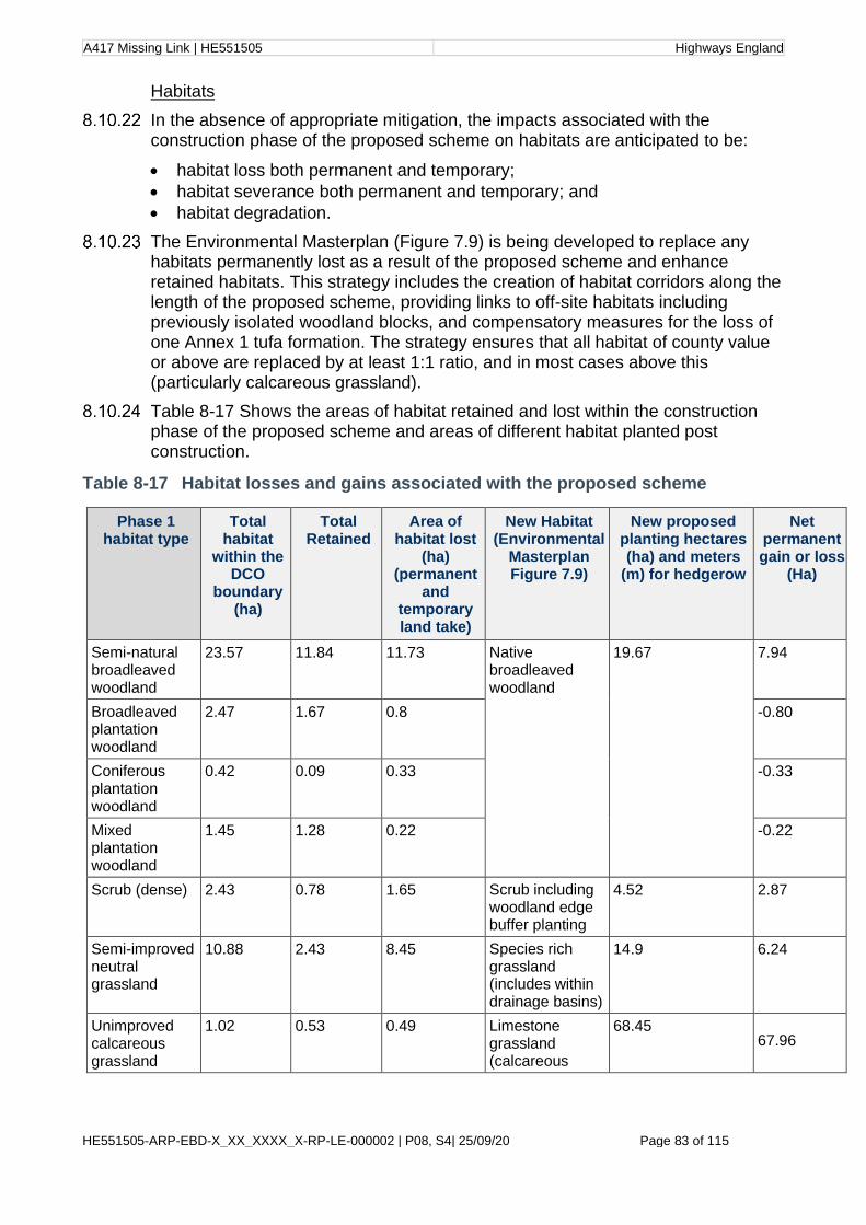
A417 Missing Link | HE551505 Highways England
HE551505-ARP-EBD-X_XX_XXXX_X-RP-LE-000002 | P08, S4| 25/09/20 Page 83 of 115
Habitats
In the absence of appropriate mitigation, the impacts associated with the construction phase of the proposed scheme on habitats are anticipated to be:
• habitat loss both permanent and temporary;
• habitat severance both permanent and temporary; and
• habitat degradation.
The Environmental Masterplan (Figure 7.9) is being developed to replace any habitats permanently lost as a result of the proposed scheme and enhance retained habitats. This strategy includes the creation of habitat corridors along the length of the proposed scheme, providing links to off-site habitats including previously isolated woodland blocks, and compensatory measures for the loss of one Annex 1 tufa formation. The strategy ensures that all habitat of county value or above are replaced by at least 1:1 ratio, and in most cases above this (particularly calcareous grassland).
Table 8-17 Shows the areas of habitat retained and lost within the construction phase of the proposed scheme and areas of different habitat planted post construction.
Table 8-17 Habitat losses and gains associated with the proposed scheme
Phase 1 habitat type
Total habitat
within the DCO
boundary (ha)
Total Retained
Area of habitat lost
(ha) (permanent
and temporary land take)
New Habitat (Environmental
Masterplan Figure 7.9)
New proposed planting hectares (ha) and meters
(m) for hedgerow
Net permanent gain or loss
(Ha)
Semi-natural broadleaved woodland
23.57 11.84 11.73 Native broadleaved woodland
19.67 7.94
Broadleaved plantation woodland
2.47 1.67 0.8 -0.80
Coniferous plantation woodland
0.42 0.09 0.33 -0.33
Mixed plantation woodland
1.45 1.28 0.22 -0.22
Scrub (dense) 2.43 0.78 1.65 Scrub including woodland edge buffer planting
4.52 2.87
Semi-improved neutral grassland
10.88 2.43 8.45 Species rich grassland (includes within drainage basins)
14.9 6.24
Unimproved calcareous grassland
1.02 0.53 0.49 Limestone grassland (calcareous
68.45 67.96

A417 Missing Link | HE551505 Highways England
HE551505-ARP-EBD-X_XX_XXXX_X-RP-LE-000002 | P08, S4| 25/09/20 Page 84 of 115
Phase 1 habitat type
Total habitat
within the DCO
boundary (ha)
Total Retained
Area of habitat lost
(ha) (permanent
and temporary land take)
New Habitat (Environmental
Masterplan Figure 7.9)
New proposed planting hectares (ha) and meters
(m) for hedgerow
Net permanent gain or loss
(Ha)
Semi-improved calcareous grassland
3.95 2.12 1.83 conservation grassland)
-1.83
Improved grassland
50.39 9.19 41.28 -41.28
Poor semi-improved grassland
54.79 14.47 40.32 -40.32
Tall ruderal 1.07 0.31 0.76 -0.76
Standing water 0.05 0.05 0 0
Total Hedgerow 5644.62 metres
- - Hedgerow 7708.05 2063.88
Arable land 26.91 11.19 15.72 -15.72
Amenity grassland
1.84 0.7 1.14 -1.14
Rock face (naturalised vegetation)
2.2 2.2
Gains of calcareous grassland, species rich neutral grassland, broadleaved woodland, scrub and hedgerow habitat are shown on the Environmental Masterplan (Figure 7.9).
A Landscape and ecological management plan (LEMP) would be developed in several stages as part of the Environmental Management Plan (EMP) to ensure the establishment and success of habitat created to replace any habitats permanently lost as a result of the proposed scheme and to maintain habitat connectivity along the length of the proposed scheme. This will be submitted with the ES.
Habitats valued at local importance and above are assessed further below.
Woodland/Trees
The majority of woodland recorded within the ZoI of the proposed scheme is broadleaved semi-natural woodland. The largest areas of woodland are designated woodland at Crickley Hill and Barrow Wake SSSI, Cotswold Beechwood SAC and Ullen Wood ancient woodland. Smaller parcels of woodland including plantation woodlands are quite isolated and surrounded by farmland.
Of the 27.91ha of all woodland within the DCO boundary, the proposed scheme would result in the loss of the following areas of woodland and trees valued as of local importance and above:
• semi-natural broadleaved woodland of national importance (11.73ha lost);
• broadleaved woodland plantation of county importance (0.8ha lost); and
• scattered trees including four veteran trees which are of national importance.
A417 Missing Link | HE551505 Highways England
HE551505-ARP-EBD-X_XX_XXXX_X-RP-LE-000002 | P08, S4| 25/09/20 Page 85 of 115
Smaller areas totalling 0.33ha and 0.22ha, of coniferous plantation and mixed woodland plantation respectively, would be lost but as these are of less than local importance and this habitat is not assessed further.
Broadleaved woodland and scattered trees:
The majority of broadleaved woodland to be lost is semi-natural, including those areas along the verges and embankments of the existing A417 from Brockworth to Air Balloon roundabout and also loss and severance of beech woodland and mixed broadleaved woodland at Shab Hill. A small area of plantation broadleaved woodland is also lost at Stockwell.
The construction would also remove a small part of the northern edge of Emma’s Grove woodland. Historical mapping shows that this woodland is not ancient woodland; however, it supports a number of ancient woodland indicator species potentially due to proximity to Ullen Wood ancient woodland. The northern section of the woodland impacted by the proposed scheme is comprised predominantly of old hazel stands and ash whilst the younger southern section of the woodland dating from approximately 1900 is predominantly beech.
New broadleaved woodland species of native variety characteristic of existing woodland would be planted along the southern verge of the new A417 from Brockworth to Crickley Hill to replace habitat that would be lost and to replace the continuous wooded corridor. Woodland planting is also proposed around the edges of a field bordering Ullen Wood currently used as grazing pasture, which would provide a buffer for the ancient woodland. Similarly, additional trees would be planted around the edge of Emma’s Grove to create a tiered buffer of vegetation including hazel scrub and other small trees which would protect against the effects of habitat severance. Woodland would also be planted at the approaches to the new Gloucestershire Way crossing, which with proposed hedgerow and tree planting, would provide connectivity of habitat between Ullen Wood and Emma’s Grove.
Species selection would include a diverse mix of native trees of local provenance, preferably sourced and grown in the UK and characteristic of the local area to ensure woodlands are resilient to climate change. Woodland planting is shown on the Environmental Masterplan (Figure 7.9).
Scattered trees and lines of trees are found throughout the study area generally within grassland fields and along minor roads. Historic maps show areas of likely wood pasture, which some of these trees could be relics of, such as at the south eastern corner of Crickley Hill. The root zones and canopies of scattered trees to be retained would be protected during construction. Measures for protection will be included in the EMP to be submitted with the ES and will refer to root protection zones stated in the Arboricultural Impact Assessment report. Replanting of specimen trees and trees within hedgerows will be detailed in the EMP.
With the planting of 19.67ha of broadleaved semi-natural woodland and additional scattered trees within pasture and hedgerows, (as shown in Table 8-17), as well as retention and protection of trees and woodland to be detailed in an EMP there would be a net gain of 7.14ha of broadleaved woodland habitat and an increase in connectivity of previously isolated woodland blocks, once this woodland was established.
A417 Missing Link | HE551505 Highways England
HE551505-ARP-EBD-X_XX_XXXX_X-RP-LE-000002 | P08, S4| 25/09/20 Page 86 of 115
The 11.73ha loss of semi-natural broadleaved woodland and scattered trees is permanent/irreversible, and the extent of loss would negatively affect the integrity of this habitat resource. The habitat loss represents a major adverse impact upon semi-natural broadleaved woodland and scattered trees, which is preliminarily assessed as a large adverse effect and significant.
The 0.8ha loss of plantation broadleaved woodland is permanent/irreversible and the extent of this loss would not negatively affect the integrity of this habitat resource. The habitat loss represents a minor adverse impact upon plantation broadleaved woodland, which is preliminarily assessed as a slight adverse effect and not significant.
The creation of approximately 19.67ha broadleaved semi-natural woodland would result in permanent addition to retained broadleaved woodland that would positively affect the integrity of this resource, once established. The habitat creation represents a major beneficial impact upon this biodiversity resource, which is preliminarily assessed as a large beneficial effect and significant.
Irreplaceable habitats including ancient woodland and veteran88 trees:
The western edge of Ullen Wood ancient woodland and Key Wildlife Site is adjacent to the A436. If limbs of overhanging trees require pruning during the construction phase in this area, the works would be undertaken by experienced arboriculturalists so as not to cause damage to mature or veteran trees. Pruning works would result in temporary/ reversible damage that would be minor in extent and would not affect the integrity or key characteristics of the ancient woodland. The pruning works represent a negligible adverse impact upon the ancient woodland, which is preliminarily assessed as a slight adverse effect and not significant.
A minimum of 15 metre buffer would be implemented between the works to create the Gloucestershire Way crossing and the canopy extent of Ullen Wood in line with Natural England guidance for development works near an ancient woodland.89 With the implementation of a protected buffer zone, there would be no observable impact upon the ancient woodland, preliminarily assessed as a neutral effect and not significant.
A material crushing compound, which in the previous 2019 iteration of the proposed scheme was situated adjacent to Ullen Wood ancient woodland, has been relocated to the southern side of the proposed mainline, over 200 metres away from the woodland boundary, to reduce the potential impacts of habitat degradation as a result of dust deposition. Mitigation measures to further reduce the risk of impacts of habitat degradation on the woodland and ground flora vegetation would still be implemented and will be included in the EMP to be submitted with the ES. With the implementation of this mitigation, dust deposition would result in temporary/reversible damage that would not affect the integrity or key characteristics of the ancient woodland Dust deposition arising from construction works represents a negligible adverse impact upon the ancient woodland, which is preliminarily assessed as a slight adverse effect and not significant.
The proposed scheme would result in the loss of four veteran trees including sycamore, apple and beech. A further five veteran trees are situated within land required temporarily for construction works, and a precautionary assumption is made for this preliminary assessment that these trees may be lost. Five veteran

A417 Missing Link | HE551505 Highways England
HE551505-ARP-EBD-X_XX_XXXX_X-RP-LE-000002 | P08, S4| 25/09/20 Page 87 of 115
trees are located adjacent to the DCO boundary and would require protection in order to be retained as detailed in the mitigation section. The veteran apple tree within the Air Balloon pub garden would either be retained or translocated to an appropriate situation within the DCO boundary. It is not possible to mitigate for the loss of veteran trees as they are irreplaceable features. The loss of up to nine veteran trees is a permanent/ irreversible impact that negatively affects the key characteristics of this resource. The loss of veteran trees represents a major adverse impact upon the veteran tree resource, which is preliminarily assessed as a large adverse effect and significant.
Hedgerows
Hedgerow surveys identified 12 species-rich hedges within 50 metres of the proposed scheme. Ten of these are classified as important hedgerows under the criteria of the Hedgerows Regulations and an additional three hedgerows qualify as important due to features other than biodiversity. The detailed hedgerow surveys results are provided in Appendix 8.2 Hedgerow technical report.
Many of the intact hedgerows are priority habitats and considered to be of national importance.
Construction activities would have the following impacts on hedgerows during the construction phase, in the absence of mitigation or suitable working practices:
• loss and fragmentation of hedgerow habitat; and
• degradation of habitat.
The proposed scheme impacts 27 of the 34 hedges surveyed with many of these being lost entirely.
The proposed scheme impacts 11 of the 13 important hedgerows (Hedgerow reference 1, 2, 9, 17,17a, 22, 23, 24, 27,28, 29 and nine species-rich hedgerows, seven of which are important hedgerows (1, 2, 9, 17, 22, 27 and 28), and 20 and 21 are species-rich but not classified as important.
With new planting of species-rich hedgerows, early translocation of valuable hedgerow habitat that is to be lost to the proposed scheme and protection of retained hedgerows, collectively there would be 7,708.05 metres of new species-rich intact hedgerow created across the proposed scheme, which offers improved connectivity to existing wooded habitat. This created hedgerow will result in a gain of approximately 2km of species-rich hedgerow.
The loss of important and priority habitat hedgerows will result in the permanent/irreversible damage to this biodiversity resource, the extent of which will negatively affect the integrity of the resource. The habitat loss represents a major adverse impact upon important and priority habitat hedgerows, which is preliminarily assessed as a large adverse effect and significant.
The creation of approximately 7.7km of species-rich native hedgerow would result in permanent addition to the retained resource of hedgerow that would positively affect the integrity of this resource, once established. The habitat creation represents a major beneficial impact upon this biodiversity resource, which is preliminarily assessed as a large beneficial effect and significant.

A417 Missing Link | HE551505 Highways England
HE551505-ARP-EBD-X_XX_XXXX_X-RP-LE-000002 | P08, S4| 25/09/20 Page 88 of 115
Grassland
Improved grassland, poor semi-improved grassland and arable land account for much of the study area and land to be lost to the proposed scheme, totalling 41.28ha, 40.32 ha and 15.72 ha respectively, for temporary and permanent land take combined. Improved grassland and arable land are of less than local importance and so are not included in the assessment.
Unimproved Calcareous grassland is only found within Crickley Hill and Barrow Wake SSSI. Two fields to the east of Barrow Wake and west of the Air Balloon pub were recorded as semi-improved calcareous grassland, one managed as horse-grazed pasture and one unmanaged. The majority of the poor semi-improved grassland recorded within the proposed scheme and adjacent areas is managed as low intensity grazing land. Smaller areas of species-rich semi-improved neutral grassland also exist, some of which support relic areas of calcareous grassland that have been lost due to lack of appropriate management.
The proposed scheme would result in the following direct losses of grassland types valued as of local importance and above:
• calcareous grassland – unimproved - national importance (0.49ha);
• calcareous grassland – semi-improved - county importance (1.83ha);
• neutral grassland - semi-improved, species-rich grassland - county importance (4.5ha),
• neutral grassland - semi-improved (other) - local importance (3.95ha); and
• neutral grassland poor semi-improved – local importance (40.32ha).
Unimproved calcareous grassland loss and potential habitat degradation at the Barrow Wake unit of the Barrow Wake and Crickley Hill SSSI are discussed and assessed in the designated sites section.
A field measuring approximately 0.5ha of semi-improved calcareous grassland will be lost due to the location of the satellite compound required for construction of the Cotswold Way crossing. The NVC survey recorded this field as poor condition NVC community CG3 grassland. Its poor condition is due to a lack of management. This field would be reinstated as calcareous grassland with a tree line post construction.
Most grassland has been categorised as poor semi-improved grassland but noted that there are localised areas of species richness. Small areas of species-rich semi-improved neutral grassland would be lost to the proposed scheme at Shab Hill. Most notably a grazed and managed meadow, measuring approximately 4.5ha, of high botanical value to the north of Shab Hill categorised as species-rich MG5a NVC community. This meadow is known to contain an abundance of orchids. The top-soil and seed bank from this field would be stored and retained in order to use it in areas of habitat creation within the proposed scheme such as the deck of the Gloucestershire Way crossing or nearby fields of poorer floristic quality.
Within the valley at Shab Hill, an area of unmanaged grassland categorised as a mosaic of neutral grassland but largely MG9b with poor relic areas of calcareous grassland transitioning to neutral. This area of grassland has more ecological value for the species it supports in terms of foraging habitat than its floristic condition and much of this grassland would be retained and protected as it is also the site for badger and bat mitigation.

A417 Missing Link | HE551505 Highways England
HE551505-ARP-EBD-X_XX_XXXX_X-RP-LE-000002 | P08, S4| 25/09/20 Page 89 of 115
The majority of grassland creation throughout the proposed scheme, on all road verges, embankments and previously arable land at the west of the proposed scheme would be calcareous grassland in keeping with the local landscape and to replace lost habitat. The creation of calcareous grassland habitat is approximately 68.45ha (a net gain of 67.96ha) as shown on the Environmental Masterplan (Figure 7.9). Seeds of native and local provenance would be used.
Some areas would be enhanced or replaced as species rich neutral grassland, for example in the areas of the dry attenuation basins and in areas where the construction impact is minimal such as fields north of Shab Hill. The total gain of neutral species rich grassland (semi improved) totals approximately 6.24ha as shown on the Environmental Masterplan. Seeds of native and local provenance would be used, or seeds from retained topsoil from the proposed scheme.
Implementation of mitigation planned early in the programme (pre-construction), such as the translocation of valuable species-rich grassland or use of seed banks, the creation of species-rich calcareous grassland as well as protection and management of retained grassland, to be detailed within the EMP to be provided with the ES, would reduce overall effects during construction.
The loss of 0.49ha of unimproved calcareous grassland is assessed within the designated sites section, as all of this habitat occurs within the Barrow Wake unit of the Barrow Wake and Crickley Hill SSSI.
The loss of 1.83ha of semi-improved calcareous grassland would result in permanent/irreversible damage that would negatively affect the integrity of the resource. The habitat loss represents a major adverse impact upon this biodiversity resource, which is preliminarily assessed as a slight adverse effect and not significant.
The loss of 4.5ha of neutral species-rich grassland habitat would result in permanent/irreversible damage that would negatively affect the integrity of the resource. The habitat loss represents a major adverse impact upon this biodiversity resource, which is preliminarily assessed as a moderate adverse effect and significant.
The loss of 3.95ha of other neutral semi-improved grassland would result in permanent/irreversible damage that would negatively affect the integrity of the resource. The habitat loss represents a major adverse impact upon this biodiversity resource, which is preliminarily assessed as a slight adverse effect and not significant.
The creation of 68.45ha of species-rich calcareous grassland would result in permanent addition to the retained resource of unimproved and semi-improved calcareous grassland that would positively affect the integrity of this resource, once established. The habitat creation represents a major beneficial impact upon this biodiversity resource, which is preliminarily assessed as a large beneficial effect and significant.
Tufaceous vegetation
The proposed scheme would result in the loss of one feature (G231) with qualifying vegetation of the Annex 1 habitat H7220 Petrifying springs with tufa formation (Cratoneurion). Whilst translocation of the tufaceous crust and associated plant assemblage was considered as a mitigation measure, several factors would be required to align for the groundwater to reach a suitable level of

A417 Missing Link | HE551505 Highways England
HE551505-ARP-EBD-X_XX_XXXX_X-RP-LE-000002 | P08, S4| 25/09/20 Page 90 of 115
high saturation and then for precipitation to occur and accumulate. In consultation with specialists, translocation was therefore ruled out due to the intricacies between the ground water and the rock it flows through and also due to the lack of any known precedent elsewhere.
The loss of the tufaceous vegetation feature (G231) would result in permanent/irreversible damage that would negatively affect the integrity of the resource. Taking a precautionary approach, this habitat loss represents a major adverse impact upon this biodiversity resource, which is preliminarily assessed as a large adverse effect and significant. Compensatory measures are currently being developed and will be included in the ES and the EMP.
Protected species
Bats
The potential impacts on bats during the construction phase are;
• habitat loss;
• degradation of habitat;
• disturbance from noise and vibration;
• severance of habitat and barrier to dispersal (habitat fragmentation).
Roost loss: Construction would result in the loss of a common pipistrelle day roost in Building 31 Woodside House (local importance) and the loss of lesser horseshoe and brown long-eared day roosts in Building 28 (county importance) Construction would also result in the loss of five tree roosts consisting of: one Natterer’s day roost (BAT ID 246245: county importance), two common pipistrelle day roosts (T33 and T163; local importance), and one multi-species day roost of common pipistrelle and a Myotis species (T63; precautionary county importance).
Replacement roosts would be provided under a mitigation licence from Natural England. The destruction of the roosts would take place at an appropriate time of year when the bats are least vulnerable. Existing tree roosting features would be salvaged where possible through careful section-felling and strapped onto nearby trees of the same species and at a similar height and orientation to that of the original tree roost. Where this is not possible, suitable bat boxes would be provided instead.
A small bat barn would be provided for the loss of the lesser horseshoe and brown long-eared day roosts in Building 28. Four woodcrete bat boxes would be provided for the loss of the common pipistrelle day roost in Building 31. The exact locations and details of the replacement roosts will be detailed within Annex D of the EMP to be provided with the ES.
With this mitigation implemented, the loss of these roosts would result in temporary/ reversible damage to the bat populations that would not affect their integrity. The roost loss represents a negligible adverse impact upon the bat assemblage, which is preliminarily assessed as being neutral and not significant.
Disturbance: Activities resulting in increased levels of noise, vibration or light can lead to bats abandoning roosts. Two tree roosts (T239 Myotis sp. day roost, T235 common pipistrelle day roost) along with a common pipistrelle maternity roost in Building 20, five common pipistrelle day roosts (in buildings 5b, 19a, 21, 31, 91), two Myotis day roosts (in buildings 20 and 21), and a long-eared species transitional roost (in building 91) lie within the DCO boundary. In addition, the

A417 Missing Link | HE551505 Highways England
HE551505-ARP-EBD-X_XX_XXXX_X-RP-LE-000002 | P08, S4| 25/09/20 Page 91 of 115
lesser horseshoe maternity roost/multi-species roost at Haroldstone House cottages which lies within 20 metres of the proposed scheme, would be subject to short-term (approximately two weeks) disturbance effects including noise, vibration, movement of plant and personnel for the rerouting of services.
Construction phase mitigation measures to reduce disturbance impacts would be drawn up in consultation with Natural England and will be detailed within Annex D of the EMP. With this mitigation implemented, disturbance impacts to these roosts would result in temporary/ reversible damage to the bat populations that would not affect their integrity. This disturbance represents a negligible adverse impact upon the bat assemblage, which is preliminarily assessed as a slight adverse effect and not significant.
All other buildings roosts identified within 20 metres of the proposed scheme (15, 16b, 23, 8a, 60, 91a, 32, 44, 33a, 45), and all tree roosts identified within 20 metres of the proposed scheme (namely Bechstein’s day roost in unconfirmed tree species at approx. chainage 2+400.000, Ullen Wood), are day/night/transitional roosts used by single or small numbers of individuals and as such are of local importance, except for the Bechstein’s tree roost which is of county importance. It is expected that given the nature of the rural environment that these bats would be able to find alternative roosting opportunities during times of particularly disturbing construction activities. Following implementation of construction mitigation as will be detailed within Annex D of the EMP, the disturbance impacts to these roosts would result in temporary/ reversible damage to the bat populations that would not affect their integrity. This disturbance represents a negligible adverse impact upon the bat assemblage, which is preliminarily assessed as a slight adverse effect and not significant.
No maternity roosts are present between 20 metres and 50 metres of the proposed scheme. Roosts in buildings between 20 and 50 metres of the proposed scheme (Buildings 33, 91b, 60b, 8b, 9, 38 and 41) are day roosts of common pipistrelle (local importance), two serotine roosts (one day roost and one unconfirmed roost, precautionary county importance due to unconfirmed roost status), two lesser horseshoe roosts (one day roost and one night roost, both of county importance) and a Myotis species day roost of county importance). All roosts in trees between 20 and 50 metres of the proposed scheme (T239, ID 239873, T24, ID 239870, T235, ID 240308, ID 239870, ID240308) are day roosts of Myotis sp., common pipistrelle, barbastelle, Natterer’s and Bechstein’s bats, of county importance (due to barbastelle and Bechstein’s). As these roosts are in close proximity to the proposed scheme, a method statement would be drawn up to reduce potential disturbance impacts such as noise and lighting on these roosts during construction and they may be included in a bat mitigation licence application as appropriate, to be detailed within Annex D of the EMP. The disturbance impacts to these roosts would result in temporary/ reversible damage to the bat populations that would not affect their integrity. This disturbance represents a negligible adverse impact upon the bat assemblage, which is preliminarily assessed as a slight adverse effect and not significant.
Habitat fragmentation: Construction would result in the severance and fragmentation of foraging habitat and commuting habitat, notably the following areas identified as important for bat activity: Crickley Hill Farm; wooded corridor along the existing A417 west of the Air Balloon roundabout, and in particular the southern side along Normans’ Brook; Cold Slad; intersection of hedgerows, tree lines and farm track north of Shab Hill; Ullen Wood; Shab Hill crescent woodland;

A417 Missing Link | HE551505 Highways England
HE551505-ARP-EBD-X_XX_XXXX_X-RP-LE-000002 | P08, S4| 25/09/20 Page 92 of 115
tree-lined road along Stockwell Farm; Birdlip Quarry. Habitat fragmentation is likely to affect all species in the identified assemblages including the four Annex II species; the only species likely to be exempt from these impacts are the open habitat adapted species (noctule, Leisler’s bat, serotine). Key roosts identified during surveys which are likely to be impacted by such fragmentation include the lesser horseshoe maternity roost at Haroldstone Cottages, the greater horseshoe day/mating/satellite breeding roost near Birdlip, and the common pipistrelle maternity roost at Stockwell Farm.
The provision of the bat underpass under the widened A417 at chainage 1+100 and The Gloucestershire Way crossing to the north of Shab Hill would provide essential mitigation for bats to address these fragmentation impacts. In addition, the detrunking of the A417, the two enhanced overbridges provided at Cowley Lane and Stockwell Farm Track, along with the additional Grove Farm underpass, created for Grove Farm access, which would cross under the A417 from Cold Slad Lane would all contribute to improving the permeability of the proposed scheme for bats, reducing fragmentation impacts.
Annex D of the EMP will include the creation of a linked mosaic of higher quality habitats, including drainage swales, hedgerows, and wood pasture, which would increase the foraging habitat to the east and west of the proposed scheme, in order to further reduce the fragmentation impacts.
Following construction mitigation which would consist of the retention of vegetation along known commuting routes for as long as possible, timing of works including the early construction of the bat underpass and the Gloucestershire Way crossing, the use of dead hedges to reduce loss of connectivity (where possible) and the use of early planting including use of accelerated planting and translocated hedgerows (as will be detailed in Annex D of the EMP), the effects of habitat fragmentation may still require some bats to seek alternative foraging resources, travel greater distances and thus expend more energy during construction. The fragmentation of bat foraging and commuting habitat would result in temporary/ reversible damage to bat populations that would negatively affect their integrity. This fragmentation represents a moderate adverse impact upon the bat assemblage, which is preliminarily assessed as a moderate adverse effect and significant.
Badgers
Survey work confirmed high levels of badger activity across the study area with 106 setts recorded within the study area and three territories identified as being severed by the proposed scheme. Desk study data included road casualties to the west and southern extents of the proposed scheme indicating that the current road network adversely impacts badgers. Badgers are however common in the local area with abundant suitable habitat in the wider landscape and are therefore assessed as being of local importance.
The potential impacts on badgers during the construction phase are;
• mortality, injury or trapping;
• disturbance from noise and vibration;
• habitat loss (including setts) and degradation; and
• severance of habitat and barrier to dispersal.

A417 Missing Link | HE551505 Highways England
HE551505-ARP-EBD-X_XX_XXXX_X-RP-LE-000002 | P08, S4| 25/09/20 Page 93 of 115
Mortality, injury and trapping: To reduce the chance of mortality and injury during construction all haul routes, compound areas and works on the live highway would be temporarily fenced off using suitable badger fencing prior to any construction activities and will be detailed in Annex D of the EMP. Permanent badger fencing will be shown on the final Environmental Masterplan (Figure 7.9) would be installed prior to the completed road network opening. Best practice methods to avoid mortality to badgers during construction as a result of vehicle collisions or entrapment in excavations will also be included in the EMP as stated in the construction mitigation section. Sett closures would be conducted under guidance and a Natural England licence which would ensure no mortality, injury or trapping of badgers, to be detailed in Annex D of the EMP. There would be no observable impact on the badger population from mortality, injury or trapping during construction.
Noise and vibration: As mentioned above, construction activities which cause noise and vibration can result in temporary disturbance which can lead to abandonment of setts and young or in the case of vibration could lead to collapse of sett tunnels leading to mortality. Suitable working methods will be incorporated in Annex D of the EMP, including the requirement that no works involving heavy machinery or piling are to be undertaken within at least 30 metres of an active badger sett, to avoid likelihood of disturbance. There would be no observable impact on the badger population from noise and vibration during construction.
Habitat loss: Based on survey results, the proposed scheme would result in the loss of badger foraging habitat and badger setts including outlier setts, subsidiary setts, annex setts and a single main sett. All setts would require closure under a Natural England licence and closure of the main sett would require the provision of an artificial sett to be functioning prior to closure of the existing main sett. The location of the proposed artificial sett is within 250 metres of the current sett, at approximate chainage 3+220. The location will be shown on the final Environmental Masterplan (Figure 7.9) to be submitted with the ES. The loss of habitat including setts would result in temporary/ reversible damage to the badger population that would negatively affect its integrity. This habitat loss represents a moderate adverse impact upon the badger population, which is preliminarily assessed as a neutral effect and not significant.
Habitat degradation: The construction activities also have the potential to cause habitat degradation and a potential loss of foraging resource for badgers as a result of pollution events and run off from construction areas including compounds and spoil heaps. The EMP will include protection measures as stated above in the construction mitigation section to reduce the likelihood of these risks. There would be no observable impact on the badger population of habitat degradation resulting from construction works
Severance during site clearance and construction could lead to isolation of badger populations both within and between clans which in a worst-case scenario could lead to local extinctions. Severance could cause an increase on conflict and competition due to a temporary reduction in territory size and foraging resource. Such effects would be reduced by careful construction programming so that certain crossing areas remain open and enough foraging areas remain available to badgers prior to final crossing points in the form of wildlife culverts being completed. Temporary fencing would be required to funnel badgers to these areas throughout the construction phase.
A417 Missing Link | HE551505 Highways England
HE551505-ARP-EBD-X_XX_XXXX_X-RP-LE-000002 | P08, S4| 25/09/20 Page 94 of 115
The creation and enhancement of habitats, and the provision of culverts under the new road proposed scheme, the Gloucestershire Way crossing and two smaller grey/green overbridges (bridges with grass verges and hedgerows) will mitigate habitat severance, although these would only become available after construction. With the implementation of the above mitigation and embedded mitigation as part of the design detailed in Chapter 2, severance of habitats and territories would result in temporary/ reversible damage to the badger population that would negatively affect its integrity. Severance of habitat represents a moderate adverse impact on badgers, which is preliminarily assessed as a slight adverse effect and not significant.
Breeding and wintering bird assemblages
The evidence from the 2019 breeding bird surveys indicates that a number of Red and Amber listed breeding species are likely to be within 250 metres of the DCO boundary. These species are considered to be of county importance.
The wintering bird surveys undertaken across 2019/2020 showed a wintering population of birds comprising a number of Red and Amber Listed species likely to be within 250 metres of the DCO boundary, which together are considered to be of county importance.
Construction activities would have the following potential impacts on breeding and wintering bird assemblages during the construction phase:
• injury/direct mortality;
• loss of breeding habitat (breeding bird assemblage only);
• loss and fragmentation of foraging habitat; and
• disturbance, including sound and lighting.
Injury/direct mortality: With mitigation measures considered, including timing of vegetation clearance and pre-construction nest checks (if works cannot be timed outside of the breeding bird season) injury/direct mortality and/or destruction of nests would be avoided. There would be no observable impact on the breeding or wintering bird assemblages resulting from injury or direct mortality during construction works.
Loss of breeding habitat: Construction activities would result in the loss of breeding bird habitat, notably hedgerows, woodland and grassland. To mitigate for loss of breeding habitat, habitat replacement would begin before construction, e.g. woodland/hedgerow planting. Nesting bird boxes would be provided for a range of species as detailed in the mitigation section. The loss of breeding habitat would result in temporary/ reversible damage to the breeding bird assemblage that would negatively affect its integrity. This habitat loss represents a moderate adverse impact upon the breeding bird assemblage, which is preliminarily assessed as a slight adverse effect and not significant.
Loss and fragmentation of foraging habitat: Loss of grassland, arable grassland and other semi-natural habitats would reduce foraging opportunities during construction. To mitigate for loss of connectivity and increased fragmentation, habitat replacement would begin before construction, e.g. woodland/hedgerow planting. Embedded mitigation including the provision of a greened multipurpose crossing and two over-bridges with hedgerows would provide mitigation for loss of connectivity.
A417 Missing Link | HE551505 Highways England
HE551505-ARP-EBD-X_XX_XXXX_X-RP-LE-000002 | P08, S4| 25/09/20 Page 95 of 115
Provision of planting and its management will be incorporated within Annex D of the EMP to reduce the effect of fragmentation on breeding and wintering birds. The loss and fragmentation of foraging habitat would result in temporary/ reversible damage to the breeding and wintering bird assemblages that would negatively affect their integrity. This habitat loss represents a moderate adverse impact upon breeding and wintering bird assemblages, which is preliminarily assessed as a slight adverse effect and not significant.
Disturbance, including sound and lighting: Construction activities on site are likely to displace breeding and wintering birds both within the proposed scheme and potentially in adjacent habitat due to disturbance from increased noise levels and visual disturbance. Noise levels would increase overall, and some are likely to be irregular in occurrence, meaning that birds are less likely to become habituated to them, although habituation is more likely where there is frequent of continuous noise or activity. Visual disturbance could also reduce the suitability of habitat for foraging. Lighting of construction areas and access routes could disturb owls, e.g. tawny owl, causing them to avoid affected foraging areas and/or impact roosting.
To mitigate for loss of habitat due to displacement from disturbance, provision of lighting design, schedule of works, planting and its management will be detailed within Annex D of the EMP. Disturbance from construction activities would result in temporary/ reversible damage to breeding and wintering bird assemblages that would not affect their integrity. This disturbance represents a negligible adverse impact upon the breeding and wintering bird assemblages, which is preliminarily assessed as a neutral effect and not significant.
Barn owl
The evidence from baseline surveys and incidental sightings of this species indicate that up to three breeding pairs of barn owls are likely to be present within 500 metres of the DCO boundary. Within the site, the habitats that occur around Shab Hill are generally considered to be of the highest value to foraging barn owls. The population of barn owl within the DCO boundary is considered to be of county importance.
Construction activities would have the following potential impacts on barn owl during the construction phase:
• injury/direct mortality from construction activities;
• loss of breeding and roosting habitat;
• loss and fragmentation of foraging habitat; and
• increased lighting and disturbance.
Injury/direct mortality: there is potential for injury and/or mortality of barn owls directly caused by construction activities. This could occur through disturbance causing abandonment of a nest (resulting in the death of dependent young birds), destruction of active nests, and/or collisions with construction vehicles. The EMP will include details of how these risks can be reduced including sensitive timing of the works and site speed limits. There would be no observable impact on the barn owl population resulting from injury or direct mortality during construction works.
Loss of breeding and roosting habitat: None of the PNS surveyed within 500 metres of the proposed scheme were occupied by breeding barn owls at the time of survey. Eight were considered suitable for occupation by nesting barn owls.

A417 Missing Link | HE551505 Highways England
HE551505-ARP-EBD-X_XX_XXXX_X-RP-LE-000002 | P08, S4| 25/09/20 Page 96 of 115
Whilst no evidence of breeding was found at any PNS, they could become occupied by breeding barn owls in the future and should be subject to re-survey prior to commencement of construction if they are to be removed or undergo significant disturbance. Barn owl populations undergo significant fluctuations, depending on factors such as the availability of prey species and weather conditions. Therefore, it is possible that breeding barn owls could occur in locations where they have previously been recorded as being absent.
There is also the potential for the loss of one ARS (within 100 metres of the proposed scheme) and potential for disturbance impacts on two TRS (within 500 metres of the proposed scheme) during the construction phase. It is likely that barn owls would temporarily disperse from areas undergoing disturbance from construction effects and would find alternative roost sites as there are suitable alternative sites in the vicinity.
Pre-construction surveys would be undertaken on all identified PNS, TRS and ARS considered suitable to ascertain whether barn owls are present or absent from works areas, in-line with the Schedule 1 legislation. The clearance and construction activities that would be required to implement the proposed scheme would result in adverse impacts upon PNS. As part of the mitigation for the proposed scheme, barn owl pole boxes would be provided, to be detailed in Annex D of the EMP. With this mitigation implemented, loss of breeding and roosting habitat would result in temporary/ reversible damage to the barn owl population that would not affect its integrity This habitat loss represents a negligible adverse impact upon the barn owl population, which is preliminarily assessed as a neutral effect and not significant.
Loss and fragmentation of foraging habitat: Permanent loss and fragmentation of Type 1 and Type 2 barn owl foraging habitat would occur as a result of construction. This is likely to be of particular significance on high quality foraging habitats around Shab Hill. It is likely that barn owls would temporarily disperse from disturbed areas of habitat and would forage in more distant and possibly less productive habitats. This has the potential to increase the risk of mortality through collision with vehicles and/or from reduced prey availability. It also has the potential to decrease breeding success for the same reasons. The loss and fragmentation of foraging habitat would result in permanent/ irreversible damage to the barn owl population that would negatively affect its integrity. This habitat loss represents a major adverse impact upon the barn owl population, which is preliminarily assessed as a moderate adverse effect and significant.
Increased lighting and disturbance: Lighting of construction areas and access routes could cause owls to avoid affected foraging areas and/or have an impact on roosting. An increase in noise and physical disturbance during construction activities has the potential to cause abandonment of roosts and/or nests, particularly if disturbance occurs during the early breeding season when birds are egg-laying or incubating. The distance (from disturbance) at which barn owls would abandon a nest would vary depending on the level of disturbance, length of disturbance and the existing disturbance levels that the birds experience. Studies suggest disturbance from human activity can be caused up to 100 metres from the nest site, although the distance at which nesting barn owls become intolerant to the approach of humans and works activities can vary depending on levels of localised day to day activity. The Forestry Commission (2007)90 sets a safe working distance from barn owls of between 100 metres to 250 metres. Lighting during construction would be designed to be sensitive to bats, which in turn would

A417 Missing Link | HE551505 Highways England
HE551505-ARP-EBD-X_XX_XXXX_X-RP-LE-000002 | P08, S4| 25/09/20 Page 97 of 115
benefit barn owls. Measures to include sensitive lighting design, timing of activities, pre-construction surveys, appropriate working distances will be included in Annex D of the EMP, which will ensure physical disturbance is avoided. Disturbance from construction activities would result in temporary/ reversible damage to the barn owl population that would not affect its integrity. This disturbance represents a negligible adverse impact upon the barn owl population, which is preliminarily assessed as a neutral effect and not significant.
Great crested newt
The population of great crested newt within the study area is considered to be of county importance.
The presence of great crested newts were confirmed during surveys within ponds at two locations within 500 metres of the proposed scheme at Crickley Hill and Birdlip. The updated desk study obtained in December 2019 and a survey report in relation to a planning application at Bentham Lane provided records of great crested newt within ponds at Bentham including one within the DCO boundary.
Construction activities are taking place within 500 metres of these populations and the following potential impacts during the construction phase have been identified:
• direct mortality; and
• habitat loss.
Direct mortality: Construction activities could result in individual great crested newts being injured and/or killed, in the absence of mitigation or suitable working practices. The majority of woodland habitat within 500 metres of the ponds would be retained and protected. It is anticipated that a precautionary working method would be agreed with Natural England and could be implemented under a low impact class licence. The working methods would include detail on watching briefs required during works within potential great crested newt terrestrial habitat. Mortality of great crested newts during construction would be minimal and there would be no observable impact on the great crested newt populations arising from direct mortality during construction works.
Habitat loss: The proposed scheme would not result in the loss of any waterbodies known to support great crested newt. Construction activities would result in a small amount (approximately 0.45ha) of potential great crested newt terrestrial habitat being lost as part of the works, predominantly comprising broadleaved woodland along the A417 road verge. The Environmental Masterplan (Figure 7.9) includes the provision of woodland, scrub and grassland habitat suitable for great crested newt foraging and shelter. In addition, the EMP will incorporate features beneficial to great crested newt such as hibernacula and log piles; the location, design and number of these will be stipulated within Annex D of the EMP. With this mitigation implemented, loss of terrestrial habitat would result in temporary/ reversible damage to great crested newt populations that would not affect their integrity This habitat loss represents a negligible adverse impact upon great crested newt populations, which is preliminarily assessed as a neutral effect and not significant.
Reptiles
Reptiles were identified at 17 locations across the proposed scheme. There are several key or important sites for reptile populations that the proposed scheme

A417 Missing Link | HE551505 Highways England
HE551505-ARP-EBD-X_XX_XXXX_X-RP-LE-000002 | P08, S4| 25/09/20 Page 98 of 115
has the potential to directly affect. These are Barrow Wake SSSI, Birdlip Quarry, Shab Hill and the field adjacent to the Air Balloon pub, which would be used as a construction compound for the Emma’s Grove footbridge. The populations of reptiles within the study area are considered to be of county importance.
Construction activities at locations with confirmed reptile presence would occur and the potential impacts during the construction phase have been identified.
• direct mortality; and
• habitat loss and fragmentation
Direct mortality: Construction activities could result in individual reptiles being injured and/or killed, in the absence of mitigation or suitable working practices. For this reason, a translocation exercise will be carried out in key reptile habitat and sites where adders were recorded and displacement of reptiles in other areas where low numbers were recorded. Adders were noted at Hedgerow 18 during walkover surveys. This hedgerow would not be impacted by the proposed scheme. Mortality of reptiles during construction would be minimal and there would be no observable impact on the reptile populations arising from direct mortality of reptiles during construction works.
Habitat loss: Construction activities will result in reptile habitat being lost. Mitigation measures will include grassland, hedgerow and woodland habitat creation suitable for reptiles and enhancement and incorporation of features beneficial to reptiles such as hibernacula and log piles. Habitat creation for reptiles will be detailed in Annex D of the EMP. Habitat creation for a translocation site will be secured prior to any construction. The two overbridges at Cowley and Stockwell and the Gloucestershire Way crossing would include hedgerows suitable for use by reptiles, resulting in three crossings available for use by reptiles to reduce fragmentation of habitat.
The loss of habitat would result in temporary/ reversible damage to the reptile populations that would negatively affect their integrity. This habitat loss represents a moderate adverse impact upon reptile populations, which is preliminarily assessed as a slight adverse effect and not significant.
Otter
Field surveys confirmed the presence of otter within the study area in tributaries of the Upper Frome, to the south of the proposed scheme. Desk study records also confirm the presence of otter at Horsbere brook, near the western extent of the proposed scheme. Otters are considered to be of county importance.
Construction activities in close proximity to watercourses could result in the following potential impacts;
• disturbance
• degradation of habitat
Disturbance: The only watercourse to be directly affected by the proposed scheme is the southern reach of Norman’s Brook. No works are proposed to Horsbere Brook, the Upper River Frome and its tributaries, or the River Churn and ephemeral tributary Coldwell Bottom. The southern section of Norman’s Brook within the DCO boundary shows no signs of use by otters due to severance from the northern reaches by a long culvert. Due to this and due to the seasonal flow, it is likely to be used only very occasionally by otters exploring the far reaches of catchments or potentially moving between catchments. In the absence

A417 Missing Link | HE551505 Highways England
HE551505-ARP-EBD-X_XX_XXXX_X-RP-LE-000002 | P08, S4| 25/09/20 Page 99 of 115
of mitigation or suitable working practices, working within 50 metres of a watercourse could cause disturbance to otters. Pre-construction surveys will determine presence of otters and mitigation requirements, such as working distances, timing of works, lighting in the proximity of watercourses and requirements for artificial holts (if required) will be detailed within Annex D of the EMP and a licence from Natural England (if required). Disturbance from construction activities would result in temporary/ reversible damage to the otter population that would not affect its integrity. This disturbance represents a negligible adverse impact upon the otter population, which is preliminarily assessed as a neutral effect and not significant.
Habitat degradation: Pollution events in the absence of mitigation could cause short and long-term impacts upon aquatic habitat that otter depend upon for survival; however, pollution control measures will be included within Annex D of the EMP. There would be no observable impact on the otter population of habitat degradation resulting from construction works
Terrestrial invertebrates
Assemblages of terrestrial invertebrates within the study area are considered to be of up to national importance, due to the invertebrate fauna of Crickley Hill.
Notable habitats supporting invertebrates on the proposed scheme include calcareous grassland, woodland including deadwood and habitat mosaics (including short-sward vegetation, rank grassland, deadwood and scrub).
Construction activities would have the following impacts on terrestrial invertebrates during the construction phase, in the absence of mitigation or suitable working practices:
• habitat loss.
Habitat loss: Construction activities would result in losses of approximately 0.49ha of calcareous grassland and 11.73ha of broadleaved semi-natural woodland for the proposed scheme.
Mitigation measures would include the creation of grassland and woodland habitat with features to benefit invertebrates such as log piles and dead wood as well as enhancement of retained habitat using translocated leaf litter and logs from lost habitats. Where possible habitats would be created prior to construction. Road verges would also be planted with species beneficial to invertebrates and managed so that there are a variety of habitat niches including bare ground as detailed in Section 8.9 Design, mitigation and enhancement measures.
With the implementation of mitigation and the avoidance of works within the Crickley Hill unit of the Crickley Hill and Barrow Wake SSSI, habitat loss would result in temporary/ reversible damage to terrestrial invertebrate assemblages that would not affect their integrity. This habitat loss represents a negligible adverse impact on invertebrates, which is preliminarily assessed as a slight adverse effect and not significant.
Roman snail
The populations of Roman snail within the study area are considered to be of local importance.

A417 Missing Link | HE551505 Highways England
HE551505-ARP-EBD-X_XX_XXXX_X-RP-LE-000002 | P08, S4| 25/09/20 Page 100 of 115
The presence of Roman snail was identified in two discrete locations and incidental records have also been identified in additional locations. Due to access constraints, assumptions about Roman snail presence have been made. Construction activities at both confirmed locations and assumed locations would occur and the following potential impacts during the construction phase have been identified:
• direct mortality; and
• habitat loss
Direct mortality: Construction activities could result in individual Roman snail being crushed. Roman snail populations would be translocated from identified habitats within the construction footprint to suitable receptor sites to comprise new or enhanced habitats for this species. The translocation exercise would be undertaken under a Natural England conservation licence, to be detailed within Annex D of the EMP. With the implementation of this mitigation, direct mortality impacts would be minimal and there would be no observable impact on the Roman snail populations arising from direct mortality during construction works.
Habitat loss: Construction activities would result in the loss of confirmed and assumed Roman snail habitat, particularly in the vicinity of Crickley Hill and road verges in this location and at the Birdlip Quarry. Mitigation measures would include the replacement of Roman snail habitat in suitable locations and enhancement of habitats within Haroldstone Fields potential KWS.
With implementation of mitigation to be detailed within the Natural England conservation licence and in Annex D of the EMP, loss of terrestrial habitat would result in temporary/ reversible damage to Roman snail populations that would not affect their integrity. This habitat loss represents a negligible adverse impact upon Roman snail populations, which is preliminarily assessed as a neutral effect and not significant.
Aquatic macroinvertebrates
Direct and indirect impacts on aquatic macroinvertebrates are anticipated within Norman’s Brook. No direct or indirect impacts are expected within the River Frome, the River Churn and their tributaries.
The proposed scheme design includes the realignment of the tributary of Norman’s Brook and the loss of several springheads due to embankment. It is likely that most adverse impacts relating to water quality and flow changes could be mitigated by the provision of alternative aquatic habitat and the creation of new springheads.
Reconstruction of the brook could locally change the groundwater regime that feeds springs and baseflow in the vicinity causing lesser or greater fluctuations in the flow regime. For impacts to spring heads and drainage, refer to Chapter 13 Road drainage and the water environment.
During the construction phase, there would be no works within tributaries associated with the River Frome or those associated within the River Churn. As such, no loss of aquatic habitat is expected.
There is potential for effects on aquatic macroinvertebrates through loss of supporting aquatic habitat, and probable risk of killing and injuring macroinvertebrates through works within Norman’s Brook. Construction activities at confirmed locations where communities of conservation importance are noted,

A417 Missing Link | HE551505 Highways England
HE551505-ARP-EBD-X_XX_XXXX_X-RP-LE-000002 | P08, S4| 25/09/20 Page 101 of 115
and the following negative potential impacts during the construction phase have been identified:
• direct mortality;
• habitat loss; and
• habitat degradation.
Direct mortality: Mortality of species is highly likely in the absence of mitigation or suitable working practices. Where the new road is proposed to extend over the Norman’s Brook, resulting in realignment of the brook, there would be a significant risk of mortality of communities of conservation importance. Construction activities could result in species of conservation importance being directly crushed and subjected to hypoxia through dewatering resulting in mortality.
The brook would be realigned under relevant guidance and EA permits. Direct mortality would be mitigated by the provision of alternative aquatic and associated riparian habitat, creation of new springheads and provision of seasonal flow. Colonisation of the new channel with aquatic macroinvertebrates would occur naturally as a result of natural drift from upstream and via airborne colonisation.
Construction mitigation to avoid and reduce any such impacts on macroinvertebrate habitats are noted above and will be included in Annex D of the EMP. With this mitigation implemented, direct mortality would result in temporary/ reversible damage to aquatic invertebrate populations that would not affect their integrity. Direct mortality represents a negligible adverse impact upon aquatic invertebrate populations, which is preliminarily assessed as a neutral effect and not significant.
Habitat loss: The creation of the new road would result in the permanent loss of potential springhead sites and the loss of potential juvenile, foraging and adult breeding habitat. Norman’s Brook would be realigned during construction of the proposed scheme. Terrestrial and aquatic habitat for macroinvertebrates would be lost. The hydrogeological assessment in Chapter 13 Road drainage and the water environment indicates that the loss of springhead habitat to embankment would be mitigated by the creation of new outflows.
No direct or indirect impacts are anticipated to affect macroinvertebrate communities living within the River Frome or the River Churn due to distance from proposed scheme and currently, no proposed works to the Rivers or their associated tributaries.
Construction mitigation to avoid and reduce any such impacts on waterbodies and associated sensitive habitats are summarised above and will be incorporated in Annex D of the EMP. With this mitigation implemented, habitat loss would result in temporary/ reversible damage to aquatic invertebrate populations that would not affect their integrity. Habitat loss represents a negligible adverse impact upon aquatic macroinvertebrate populations, which is preliminarily assessed as a neutral effect and not significant.
Habitat degradation: Habitats close to the proposed scheme, such as hydrologically connected aquatic habitats, are sensitive to effects from construction such as pollution events from fuel and chemical spills, from change in vehicle emissions, and from sediment run-off. Runoff of substrate associated with the construction could result in increased siltation of Norman’s Brook

A417 Missing Link | HE551505 Highways England
HE551505-ARP-EBD-X_XX_XXXX_X-RP-LE-000002 | P08, S4| 25/09/20 Page 102 of 115
watercourse as Norman’s Brook becomes seasonally wet. This could result in the temporary reduction of macroinvertebrate abundance and diversity.
Construction mitigation to avoid and reduce any such impacts on waterbodies and associated sensitive habitats will follow pollution prevention best practice and will be incorporated in Annex D of the EMP.
Changes to the groundwater flow into the Rivers Churn and Frome are not predicted to be impacted by the construction of the road. No change is expected in the hydrological regime of either river. No reduction in water quality is expected due to reduced dilution of pollutants.
With the implementation of the mitigation measures outlined above, there would be no observable impact on aquatic macroinvertebrates of habitat degradation resulting from construction works.
Fish
Due to the absence of baseline fish data from the upper reaches of Norman’s Brook, assumptions on species presence and likely significant effects to fish have been made based on a precautionary ‘reasonable worst case’ basis.
Potential direct impacts within Norman’s Brook to resident fish such as European bullhead, European eel and brook lamprey is highly likely due to the temporary loss of habitat and realignment. Direct impacts to anadromous fish species such as salmonids and sea lamprey are unlikely due to seasonality of flow and barriers to fish passage identified during the fish habitat assessment.
Due to the absence of field surveys being conducted and lack of baseline data from within the proposed scheme and the ZoI, assumptions about migratory fish species and resident communities of fish present within the proposed scheme and the ZoI have been made based on habitat assessments and review of background data provided by the Environment Agency.
The proposed scheme would involve the realignment of the tributary of Norman’s Brook and the loss of habitat suitable for brown trout, European bullhead, brook lamprey and European eel. These potential habitats were identified in fish mapping conducted during baseline surveys. Reconstruction of the brook could locally change the groundwater regime that feeds springs and baseflow in the vicinity causing lesser or greater fluctuations in the flow regime. It is likely that most adverse impacts could be mitigated by standard mitigation such as the provision of alternative aquatic habitat and fish translocation prior to dewatering.
Construction activities at confirmed locations where migratory and resident communities of fish of conservation importance have the potential to habit and the following potential impacts during the construction phase have been identified:
• direct mortality;
• habitat degradation;
• habitat loss; and
• disturbance.
Direct mortality: Mortality of species is highly likely in the absence of mitigation or suitable working practices. Construction activities could result in adult fish of conservation importance being directly killed or injured, eggs laid in spawning habitats destroyed or damaged, juveniles killed or injured, and hypoxia through dewatering resulting in death.

A417 Missing Link | HE551505 Highways England
HE551505-ARP-EBD-X_XX_XXXX_X-RP-LE-000002 | P08, S4| 25/09/20 Page 103 of 115
Pre-construction surveys would be conducted to confirm species presence/absence and to inform any additional mitigation measures necessary to avoid fish mortality. With this mitigation implemented, direct mortality would result in temporary/ reversible damage to fish populations that would not affect their integrity. Direct mortality represents a negligible adverse impact upon fish populations, which is preliminarily assessed as a neutral effect and not significant.
Habitat degradation: Indirect impacts such as changes in hydrology and water quality to resident fish within Norman’s Brook is highly likely due to realignment and increase in the potential for pollution events, in the absence of mitigation. Habitats close to the proposed scheme, such as hydrologically connected aquatic habitats, are sensitive to effects from construction such as pollution events from fuel and chemical spills, from change in vehicle emissions, and from sediment run-off.
The brook would be realigned under relevant guidance and EA permits. Construction activities at confirmed locations where fish populations are noted (through pre-construction surveys) would be sensitively timed as stated in the construction mitigation section.
No direct impacts on fish within the River Churn or Frome are anticipated, as no construction works are required within these rivers. There are no predicted indirect impacts to the River Frome and the River Churn through hydrological changes.
Construction mitigation to avoid and reduce any such impacts on fish habitats are described above and will be detailed within the EMP. With the implementation of these mitigation measures, there would be no observable impact on fish populations of habitat degradation resulting from construction works.
Habitat loss: Habitat suitable for brown trout, juvenile lamprey, European eel and European bullhead habitat identified in Norman’s Brook during field surveys would be lost during construction works. The identification of this habitat does not indicate the presence of species. A precautionary approach has been taken should be taken regarding the presence of brown trout, European eel, European bullhead and lamprey within this waterbody.
As above, the brook would be realigned, prior to construction, under relevant guidance and EA permits. Construction activities at confirmed locations where fish populations are noted (through pre-construction surveys) would be sensitively timed as stated in the construction mitigation section.
Riparian and aquatic habitat found at the River Frome and River Churn is not expected to be lost to the current proposed scheme proposals; therefore, no impacts are considered to occur.
With the implementation of mitigation, habitat loss would result in temporary/ reversible damage to fish populations that would not affect their integrity. Habitat loss represents a negligible adverse impact upon fish populations, which is preliminarily assessed as a neutral effect and not significant.
Disturbance: Site clearance and construction activities would result in increased noise disturbance which has the potential to impact upon fish.
To mitigate the effects of disturbance to fish populations, in channel works and the dewatering of Norman’s Brook would proceed following pre-construction fish surveys to inform a fish translocation strategy to be undertaken under EA licence.

A417 Missing Link | HE551505 Highways England
HE551505-ARP-EBD-X_XX_XXXX_X-RP-LE-000002 | P08, S4| 25/09/20 Page 104 of 115
With the inclusion of the mitigation set out in Chapter 13 Road drainage and the water environment, disturbance would result in temporary/ reversible damage to fish populations that would not affect their integrity. Disturbance represents a negligible adverse impact upon fish populations, which is preliminarily assessed as a neutral effect and not significant.
Other Section 41 Species of Principal Importance
Habitat suitable for SPI (other than those discussed above), especially hedgehog and common toad (both found incidentally during surveys for other species and the desk study) and potentially harvest mouse, brown hare and polecat (none incidentally observed or within desk study), are present within the study area and proposed scheme. Due to only occasional individuals being observed and a few records from the desk study within 1.2 miles (2 kilometres), the SPI species populations as above are considered to be of local importance (if present).
During construction, potential impacts could occur through permanent and temporary habitat loss, severance and disturbance, as well as individual mortality. However, embedded mitigation and best practice techniques, such as habitat clearance designed and timed to be sensitive to these species, alongside habitat manipulation clearance techniques to deter species away from areas, would remove or reduce these risks. Provisions would be made where any animals found during construction are moved by the Ecological Clerk of Works (ECoW) to the most appropriate mitigation areas. For example, provisions for common toad would be made adjacent to wet areas. This approach will be detailed within Annex D of the EMP.
With the inclusion of these mitigation measures it is considered that construction works would result in in temporary/ reversible damage to populations of other SPI that would not affect their integrity. Construction works would have a negligible adverse impact upon SPI populations, which is preliminarily assessed as a neutral effect and not significant.
Operation effects
Designated sites
The potential impacts of the operational phase on statutory designated sites would be
• Habitat degradation as a result of visitor pressure and as a result of change in air quality, specifically nitrogen deposition.
A Habitat Regulations Assessment (HRA) is being undertaken due to the presence of internationally designated sites located within 1.2 miles (2 kilometres) and 18.6 miles (30 kilometres) of the proposed scheme, and due to those located within 200 metres of the Affected Road Network for air quality and where the site crosses or lies adjacent to, upstream of, or downstream of, a watercourse which is designated in part of wholly an international site, in accordance with DMRB LA 115 Habitats Regulations assessment (formerly HD 44/09).
Visitor pressure: One of the key potential effects from the proposed scheme relates to potential increase in visitor pressure on the Cotswold Beechwoods SAC. This designated site is being assessed concurrently with this PEI report, subject to Stage 2 Appropriate Assessment and will be included in a Statement to Inform Appropriate Assessment (SIAA) which will be provided alongside the ES.
A417 Missing Link | HE551505 Highways England
HE551505-ARP-EBD-X_XX_XXXX_X-RP-LE-000002 | P08, S4| 25/09/20 Page 105 of 115
The preliminary SIAA indicates that provision of the alternative recreational route provided as part of the proposed scheme along the de-trunked Air Balloon Way would avoid any adverse effect on the integrity of the SAC. This indicates that with mitigation there would be no observable impact on the SAC resulting from increased visitor pressure.
Nitrogen deposition: The new roundabout adjacent to the Barrow Wake SSSI would result in an increase in traffic adjacent to the designated site. However, the traffic along the existing A417 which currently bisects the SSSI would be removed. As described in Chapter 5 Air quality, the proposed scheme would give rise to slight improvements in air quality at the Barrow Wake unit of the Crickley Hill and Barrow Wake SSSI with a reduction in nutrient nitrogen deposition predicted to be -0.7kg N/ha/yr from baseline conditions of 37.4kg N/ha/yr to 36.7kg N/ha/yr in 2024. This measurement is from a point on transect ED1, 20 metres away from the current road alignment near the entrance to Barrow Wake carpark.
Improvements in air quality are also predicted at the Crickley Hill Unit of the SSSI as traffic is moved further away from the designated site. Changes in air quality therefore are considered to be not significant as defined in DMRB LA 105.
Reductions of NOx emissions and nitrogen deposition on designated sites during operation, especially calcareous grassland in the case of the Barrow Wake unit of the SSSI, would result in a permanent improvement to this site that would not affect their integrity. These reductions represent a negligible beneficial impact on the SSSI, which is preliminarily assessed as a slight beneficial effect and not significant.
Habitats
There is potential for degradation of woodland, hedgerow and grassland habitat as a result of pollution from road traffic or surface water run -off during operation of the road proposed scheme. With the embedded mitigation in the form of planting and attenuation basins to manage surface water run-off and pollution events from the road, there would be no observable impact on habitats within the ZoI from pollution events during the operational phase of the proposed scheme.
Protected species
Bats
Operational activities would have the following potential impacts on bats during the operational phase;
• increased risk of road mortality or injury; and
• habitat fragmentation/barrier to dispersal; and
• potential reduction in functionally linked habitat for each of the bat populations relevant to the Wye Valley and Forest of Dean Bat Sites SAC (this will be specifically assessed in the Habitats Regulation Assessment Stage 1 Screening Report in accordance with DMRB LA 115 Habitats Regulations assessment (formerly HD 44/09), which will be provided alongside the ES.
Direct mortality: Collision resulting in mortality of bats occurs in areas where bats would attempt to cross the highway when following existing or new linear features (hedgerows, tree lines, and other features). This is particularly relevant to the woodland species present along the proposed scheme such as horseshoe

A417 Missing Link | HE551505 Highways England
HE551505-ARP-EBD-X_XX_XXXX_X-RP-LE-000002 | P08, S4| 25/09/20 Page 106 of 115
bats, which are more reluctant to fly in the open and tend to commute along linear features in the landscape and woodland edges. Although agile and manoeuvrable in flight, most bat species fly at low speeds (< 20 km/h) and many fly close to the ground (0-4 metres: e.g. Russell et al. 200991, Berthinussen and Altringham 201292), particularly when crossing open spaces, at heights that may bring them into the path of oncoming vehicles.
Studies have highlighted three mortality peaks during the year93: at the end of hibernation, when adults need to intensively forage in order to build up energy supplies; at the end of summer, when young-of-the-year begin to fly and are in dispersal phase; and from September to October, when bat populations are at their peak numbers, seeking to mate and to build up fat reserves for hibernation. Juvenile bats are considered to be more vulnerable to collision mortality; as such, the close proximity of any maternity roost may heighten the risk of collision. Embedded mitigation includes the provision of false cuttings and associated planting where the proposed scheme is on embankment (to be planted in as soon as possible before opening) to provide suitable cover to help raise bat flight paths above the level of traffic. Structural planting on both sides of the proposed scheme would help guide bats towards safe crossing points, where the risk of collision is reduced; these provisions include:
• Bat underpass at CH1+100.
• Gloucestershire Way crossing;
• Cowley overbridge; and
• Stockwell overbridge.
The mitigation measures incorporated into the proposed scheme are considered suitable to maintain a permeable landscape for foraging and commuting bats in the wider landscape. However, the loss of the mature woodland corridor west of the Air Balloon roundabout would result in permanent/ irreversible damage to commuting and foraging bats that would not affect the integrity of the bat populations. This represents a minor adverse impact on commuting and foraging bats, which is preliminarily assessed as a slight adverse effect and not significant.
Habitat fragmentation: Increased light levels associated with the live traffic in the eastern section of the proposed scheme could deter bats and alter their behaviour. However, the measures incorporated into the proposed scheme such as cuttings, solid parapets on all overbridges, the de-trunking of a section of the existing A417 and planting regime are considered to mitigate the impacts associated with increased light spill from vehicle lights onto surrounding habitat. With mitigation, increased light levels from traffic would result in permanent/ irreversible damage to commuting and foraging bats that would not affect the integrity of the bat populations. This represents a minor adverse impact on commuting and foraging bats, which is preliminarily assessed as a slight adverse effect and not significant.
A number of roosts would be subject to higher noise levels as a result of the proposed scheme in operation. In turn, a number of roosts would see a reduction in noise levels as a result of the proposed scheme in operation. Increased noise levels could also affect foraging bats, specifically the species that use passive listening as a foraging technique.
Whilst these increases in noise level may be deemed an adverse effect in EIA terms for humans, see Chapter 11 Noise and vibration, there is little evidence to show what constitutes a significant adverse effect for bats. In their paper on the

A417 Missing Link | HE551505 Highways England
HE551505-ARP-EBD-X_XX_XXXX_X-RP-LE-000002 | P08, S4| 25/09/20 Page 107 of 115
effects of anthropogenic noise on foraging bats, Schaub, et al (200894) identify that whilst traffic noise and other sources of intense broadband noise are shown to degrade the suitability of foraging areas, there are many examples of bats roosting in extremely noisy situations (bell towers of churches or under motorway bridges). It should also be noted that some roosts would benefit from a decrease in noise levels, in particular (but not limited to) the common pipistrelle maternity roost in building 20, and the lesser horseshoe and serotine day roosts in building 60b. No observable impacts of noise during operation on roosting bats are anticipated, either positive or negative.
Badger
Operational activities would have the following potential impacts on badgers during the operation phase:
• risk of road mortality or injury
Risk of mortality and injury: There is an inherent increased potential risk of mortality through traffic collision, associated with badger crossing the carriageway as identified by the desk study records of badger fatalities. The inclusion of crossing points in the form of three badger culverts have been included in the design of the proposed scheme where the road severs identified badger territories which would restore safe crossing points for badgers within their territories and across the wider landscape. Badgers could potentially use the bat underpass at CH1 +100 at the western end of the proposed scheme which provides additional opportunity to cross the A417 rather than using the road underpass at Bentham as they currently do. An access underbridge at Grove Farm (Grove Farm underpass) offers another crossing opportunity between woodland to the north and south of the existing A417.
The installation of badger fencing and hedgerow, woodland tree and scrub planting would assist in encouraging and channelling movement of badgers away from the highway and through safe culverts, underpasses and overbridges.
With the appropriate mitigation implemented including fencing the majority of the proposed scheme and the provision of safe crossing points the risk of mortality to badgers has reduced in comparison to the current situation. Reduced mortality risk would result in a permanent improvement for the badger population that would not affect its integrity. This represents a minor beneficial impact upon the badger population, which is preliminarily assessed as a slight beneficial effect and not significant.
Breeding and wintering birds
Operational activities would have the following potential impacts on breeding and wintering bird assemblages during the operation phase, in the absence of mitigation or suitable working practices:
• increased risk of road mortality; and
• disturbance, including sound and lighting.
Increased risk of road mortality: The existing A417 already provides a risk to birds from collisions, however the proposed scheme would increase this risk with the wider extent from dualling. The provision of the crossing points in the form of the Gloucestershire Way crossing and two smaller overbridges and the embedded landscaping including steep embankments and reduced vegetation on

A417 Missing Link | HE551505 Highways England
HE551505-ARP-EBD-X_XX_XXXX_X-RP-LE-000002 | P08, S4| 25/09/20 Page 108 of 115
verges (used for foraging/connectivity), would improve connectivity and reduce mortality risk. In addition, the installation of fencing and planting would assist in encouraging and channelling movement through underpasses and bridges. With this mitigation implemented, direct mortality would result in permanent/ irreversible damage to bird assemblages that would not affect their integrity. Direct mortality represents a minor adverse impact upon bird assemblages, which is preliminarily assessed as a neutral effect and not significant.
Disturbance, including noise and lighting: The proposed scheme would increase operational disturbance through primarily noise and lighting (from traffic). Increased noise is likely to displace birds both away from the immediate proposed scheme area, but also adjacent habitats where sound level changes are significant, and disturbance can cause functional habitat loss.
The conversion of the southern section of the existing A417 to a WCH would reduce noise and vehicle lighting. This is likely to increase functional connectivity across the landscape. There is likely to be the largest increase in noise and vehicular lighting disturbance around Shab Hill, which was shown to support linnet, yellowhammer and skylark populations.
Habitat is to be provided at distance, where possible, from the proposed scheme where operational levels of noise are similar to background levels (pre-proposed scheme) in order to mitigate with functional habitat. With this mitigation implemented, disturbance would result in permanent/ irreversible damage to bird assemblages that would not affect their integrity. Disturbance represents a minor adverse impact upon bird assemblages, which is preliminarily assessed as a neutral effect and not significant.
Barn owl
Operational activities would have the following potential impacts on barn owl during the operational phase:
• increased risk of road injury/mortality; and
• increased lighting and disturbance.
Increased risk of injury/mortality: the realignment and widening of the road, improvements to traffic congestion and increased traffic speed would cause an increased risk of road mortality of barn owls. This is particularly relevant to young birds dispersing in the autumn months. The ARS identified in the Stage 1 and 2 report near Fly Up bike park show that barn owls are present within 100 metres of the current A417 and are at high risk from road mortality. Studies estimate that between 3,000 and 5,000 barn owls are killed on roads annually, with over 90% of these fatalities occurring on major roads (motorways and dual carriageways)95. The rough grass verges alongside major roads provide long stretches of habitat for barn owl prey species and birds would frequently fly across the road at low height, resulting in the potential for direct conflict with traffic. The presence of major roads can cause the absence of breeding barn owls within 0.3 miles (0.5 kilometres) on either side of the road, with negative impacts detected up to 15.5 miles (25 kilometres) away from a major road96. Where the road realignment crosses existing areas of Type 1 and 2 habitats, mortality through collision with vehicles is likely to be highest.
Mitigation would include strategic planting of woody species of a height of at least 3 metres in areas considered to be of high collision risk, for example at Shab Hill to encourage barn owls to fly high over the road network and planting and
A417 Missing Link | HE551505 Highways England
HE551505-ARP-EBD-X_XX_XXXX_X-RP-LE-000002 | P08, S4| 25/09/20 Page 109 of 115
management of grassland verges, keeping grassland short in specified areas or planting scrub to reduce the habitat suitability for small mammals and therefore decrease the foraging potential for barn owls. Planting design has aimed to provide suitable foraging and commuting routes for barn owls to connect existing habitat each side of the road corridor where barn owls are known to be present.
Increased mortality of barn owl would result in permanent/ irreversible damage to the barn owl population that would negatively affect its integrity. Increased mortality risk represents a major adverse impact on the barn owl population, which is preliminarily assessed as a moderate adverse effect and significant.
Disturbance, including noise and lighting: The proposed scheme would increase operational disturbance through primarily noise and lighting (from traffic). Disturbance from this source would result in permanent/ irreversible damage to the barn owl population that would not affect its integrity. Disturbance represents a minor adverse impact upon the barn owl population, which is preliminarily assessed as a slight adverse effect and not significant.
Great crested newt
No observable direct or indirect impacts during the operational phase of the proposed scheme upon great crested newt are anticipated.
Reptiles
No observable direct or indirect impacts during the operational phase of the proposed scheme upon reptiles are anticipated.
Otter
Otter are recorded in the northern section of Norman’s Brook, but not in the southern reaches to the south of the A417. It is therefore considered unlikely that otters attempt to cross the A417 either over ground or via the long culvert. The desk study returned no records of road fatalities along the A417; however, it did return a record of a road casualty at Brockworth to the south of the proposed scheme near Horsbere Brook. Otters were not recorded in the southern reaches of Norman’s Brook which is the watercourse closest to the road network and were not recorded in any other watercourses within 250 metres of the proposed scheme. Therefore, no observable direct or indirect impacts during the operational phase of the proposed scheme upon otter are anticipated.
Terrestrial invertebrates (including Roman snails)
No observable direct or indirect impacts during the operational phase of the proposed scheme upon terrestrial invertebrates are anticipated.
Aquatic invertebrates
Potential indirect impacts of the proposed scheme on macroinvertebrate communities include increased sedimentation, hydrological changes to springheads and increased pollution events through surface run off or groundwater feeds. Some species of aquatic macroinvertebrates are sediment sensitive and thus changes to suspended sediment or the bed substrate could result in loss of potential species. All operational impacts that are likely to effect aquatic receptors are identified within Chapter 13 Road drainage and the water environment.

A417 Missing Link | HE551505 Highways England
HE551505-ARP-EBD-X_XX_XXXX_X-RP-LE-000002 | P08, S4| 25/09/20 Page 110 of 115
Embedded mitigation in design to avoid or reduce these impacts have been included and described within Chapter 13 Road drainage and the water environment, including road drainage and attenuation ponds to mitigate impacts. As such, there would be no observable impact on aquatic invertebrates from the operational phase of the proposed scheme.
Fish
Potential operational effects on fish communities are the same as descried above for aquatic macroinvertebrates, as are the embedded mitigation measures. As such, there would be no observable impact on fish populations from the operational phase of the proposed scheme.
Other Section 41 Species of Principal Importance
There is an inherent risk of mortality through traffic collision, associated with SPIs crossing the carriageway. Crossing points have been included in the design in the form of culverts and overbridges and an underpass to improve connectivity and reduce mortality risk, as well as the provision of badger fencing throughout the proposed scheme to prevent access to the road network. With the incorporation of this embedded mitigation the risk of mortality from operation of the proposed scheme has reduced for several SPI in comparison to the current situation. Reduced mortality risk would result in a permanent improvement for SPI populations that would not affect their integrity. This represents a minor beneficial impact upon SPI populations, which is preliminarily assessed as a slight beneficial effect and not significant.
8.11 Monitoring
Where significant adverse environmental effects are reported for a scheme, projects shall undertake monitoring in accordance with LA 104.
Details of monitoring will be agreed with Highways England and will be summarised in the Environmental Statement and detailed within the Landscape and Ecological Management Plan (LEMP) developed as an Annex of the Environmental Management Plan (EMP) to be submitted with the ES.
8.12 Summary
The preliminary assessment of impacts of the proposed scheme on biodiversity has identified a range of effects during construction and operation. The likely residual significant effects during construction and operation are summarised in Table 8-18 and Table 8-19 respectively.

A417 Missing Link | HE551505 Highways England
HE551505-ARP-EBD-X_XX_XXXX_X-RP-LE-000002 | P08, S4 | 25/09/20 Page 111 of 115
Table 8-18 Summary of preliminary assessment of likely significant construction effects
Ecological receptor
Description of potential impact
Embedded design, mitigation, and enhancement measures
Importance of receptor
Duration and reversibility
Magnitude of impact Significance of potential effect
Barrow Wake Unit of Crickley Hill and Barrow Wake SSSI
Loss of approximately 0.07ha of calcareous grassland and 0.03ha of broadleaved trees within the Barrow Wake Unit of the SSSI
Compensatory planting in the form of calcareous grassland and reinstatement of some topsoil with retained seedbank where possible to replace SSSI habitat lost.
National Permanent/ irreversible
Minor Adverse Moderate adverse (significant)
Semi-natural broadleaved woodland and scattered trees
Loss of semi-natural broadleaved woodland along verges and embankments, and loss and severance of beech woodland at Shab hill.
Retention and protection of woodland and trees wherever loss can reasonably be avoided
National Permanent/ irreversible
Major adverse Large adverse (significant)
Semi-natural broadleaved woodland
Creation of approximately 19.67ha
n/a National Permanent Major beneficial Large beneficial (significant)
Veteran trees Loss of veteran trees
It is not possible to mitigate against the loss of veteran trees.
National Permanent/ irreversible
Major adverse Large adverse (significant)
Hedgerows Loss of Important and
Translocation of valuable hedgerows where appropriate
National Permanent/ irreversible
Major adverse Large adverse (significant)
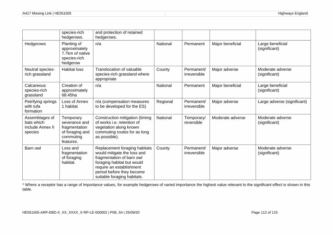
A417 Missing Link | HE551505 Highways England
HE551505-ARP-EBD-X_XX_XXXX_X-RP-LE-000002 | P08, S4 | 25/09/20 Page 112 of 115
* Where a receptor has a range of importance values, for example hedgerows of varied importance the highest value relevant to the significant effect is shown in this table.
species-rich hedgerows.
and protection of retained hedgerows.
Hedgerows Planting of approximately 7.7km of native species-rich hedgerow
n/a National Permanent Major beneficial Large beneficial (significant)
Neutral species-rich grassland
Habitat loss Translocation of valuable species-rich grassland where appropriate
County Permanent/ irreversible
Major adverse Moderate adverse (significant)
Calcareous species-rich grassland
Creation of approximately 68.45ha
n/a National Permanent Major beneficial Large beneficial (significant)
Petrifying springs with tufa formation
Loss of Annex 1 habitat
n/a (compensation measures to be developed for the ES)
Regional Permanent/ irreversible
Major adverse Large adverse (significant)
Assemblages of bats which include Annex II species
Temporary severance and fragmentation of foraging and commuting features.
Construction mitigation (timing of works i.e. retention of vegetation along known commuting routes for as long as possible).
National Temporary/ reversible
Moderate adverse Moderate adverse (significant)
Barn owl Loss and fragmentation of foraging habitat.
Replacement foraging habitats would mitigate the loss and fragmentation of barn owl foraging habitat but would require an establishment period before they become suitable foraging habitats.
County Permanent/ irreversible
Major adverse Moderate adverse (significant)

A417 Missing Link | HE551505 Highways England
HE551505-ARP-EBD-X_XX_XXXX_X-RP-LE-000002 | P08, S4 | 25/09/20 Page 113 of 115
Table 8-19 Summary of preliminary assessment of likely significant operation effects
Ecological receptor
Description of potential impact
Embedded design, mitigation, and enhancement measures
Importance of receptor
Duration and
reversibility
Magnitude of impact
Significance of potential effect
Barn owl Increased risk of mortality and injury through traffic collisions, and severance of habitat, due to increased traffic speed and wider road.
There would be strategic planting of woody species to encourage barn owls to cross the road at a safe height, and the width of grass verges would be reduced in sensitive areas. Habitat on roadside verges would also be managed as short grassland so as not to provide suitable foraging habitat for barn owl adjacent to the road.
County Permanent/ irreversible
Major adverse
Moderate adverse (significant)

A417 Missing Link | HE551505 Highways England
HE551505-ARP-EBD-X_XX_XXXX_X-RP-LE-000002 | P08, S4 | 25/09/20 Page 114 of 115
Further Work
The next steps for the biodiversity assessment are to:
• Complete remaining baseline surveys where land access has not been madeavailable to complement the current understanding of the ecological featurespresent (findings not considered to affect the preliminary assessment);
• Complete groundwater modelling to confirm whether there are any impacts toground water dependent habitats such as fen meadow found at BushleyMuzzard SSSI.
• Further work on earthworks levels in several areas of the scheme and tosecure the opportunity to avoid the veteran tree in the Air Balloon pub garden.
• Complete a calculation of the losses and gains associated with the proposedscheme using the biodiversity net gain Defra 2.0 metric.
• Develop proportionate monitoring measures where there are significantadverse environmental effects.
• Develop a Landscape and Ecological Management Plan (LEMP) which will setout how the landscape design and ecology mitigation measures shall bedelivered and managed for the proposed scheme.
A417 Missing Link | HE551505 Highways England
HE551505-ARP-EBD-X_XX_XXXX_X-RP-LE-000002 | P08, S4 | 25/09/20 Page 115 of 115
Endnotes and References
1 Highways England, Transport Scotland, Welsh Government, and Department for Infrastructure,
“Design Manual for Roads and Bridges Sustainability and Environment Appraisal LA 108 Biodiversity Revision 1,” 2020
2 Department for Transport, “National Policy Statement for National Networks,” Williams Lea Group on behalf of the Controller of Her Majesty's Stationery Office, 2014.
3 Highways England, “Highways England Delivery Plan 2020-2025,” 2020. Accessed 21/08/2020 https://www.gov.uk/government/publications/highways-england-delivery-plan-2020-2025
4 Department for Transport, Road Investment Strategy: for the 2020 – 2025 Road Period. 2020.
5 Joint Nature Conservation Committee, “UK Post-2010 Biodiversity Framework | JNCC - Adviser to Government on Nature Conservation,” 2012. [Online]. Available: https://jncc.gov.uk/our-work/uk-post-2010-biodiversity-framework/. [Accessed: 20-Nov-2019]
6 Cotswold District Council, “Biodiversity & planning policy,” 2015. [Online]. Available: https://www.cotswold.gov.uk/residents/planning-building/wildlife-biodiversity/biodiversity-planning-policy/#. [Accessed: 20-Nov-2019]
7 Cotswolds Conservation Board, 2018 “Cotswolds Area of Outstanding Natural Beauty Management Plan 2018-2023,”
8 Highways England, Transport Scotland, Welsh Government, and Department for Infrastructure, “Design Manual for Roads and Bridges Sustainability and Environment Appraisal LA 108 Biodiversity Revision 1,” 2020:
9 Highways England, Transport Scotland, Welsh Government, and Department for Infrastructure,
“Design Manual for Roads and Bridges Sustainability and Environment Appraisal LA 104 Environmental assessment and monitoring
10 Highways England, Transport Scotland, Welsh Government, and Department for Infrastructure,
“Design Manual for Roads and Bridges Sustainability and Environment Appraisal LA 115 Habitats Regulations assessment
11 Chartered Institute of Ecology and Environmental Management, “Guidelines For Ecological Impact Assessment In The UK And Ireland Terrestrial, Freshwater, Coastal And Marine,” 2019
12 Natural England (2018) Ancient woodland, ancient trees and veteran trees: protecting them from
development
13 Chartered Institute of Ecology and Environmental Management, “Guidelines For Ecological Impact Assessment In The UK And Ireland Terrestrial, Freshwater, Coastal And Marine,” 2019
14 S. Wray, D. Wells, E. Long, and M.-J. Tony, “Valuing Bats in Ecological Impact Assessment,” Institute of Ecology and Environmental Management: In Practice, pp. 23–25, 2010
15 Such species include those listed within Council Directive 79/409/EEC on the conservation of
wild birds or animal/plant species listed within Council Directive 92/43/EEC.
16 Chartered Institute of Ecology and Environmental Management, “Guidelines For Ecological Impact Assessment In The UK And Ireland Terrestrial, Freshwater, Coastal And Marine,” 2019
17 Chartered Institute of Ecology and Environmental Management, “Guidelines For Ecological Impact Assessment In The UK And Ireland Terrestrial, Freshwater, Coastal And Marine,” 2019
A417 Missing Link | HE551505 Highways England
HE551505-ARP-EBD-X_XX_XXXX_X-RP-LE-000002 | P08, S4 | 25/09/20
18 ‘The ‘zone of influence’ for a project is the area over which ecological features may be subject to significant effects as a result of the proposed project and associated activities. This is likely to extend beyond the project site, for example where there are ecological or hydrological links beyond the site boundaries. The zone of influence will vary for different ecological features depending on their sensitivity to an environmental change. It may be appropriate to identify different zones of influence for different features.
19LD 118 Biodiversity design (March 2020): https://www.standardsforhighways.co.uk/dmrb/search/9317652b-4cb8-4aaf-be57-b96d324c8965
20 Chartered Institute of Ecology and Environmental Management, “Guidelines For Ecological Impact Assessment In The UK And Ireland Terrestrial, Freshwater, Coastal And Marine,” 2019
21 WSP (2006) Stage 2 Assessment were reported in 'A417 Cowley to Brockworth Bypass Improvement Scheme - Stage 2 Ecology and Nature Conservation Report
22 Joint Nature Conservation Committee, “Handbook for Phase 1 Habitat Survey A technique for environmental audit,” 2010
23 Mott MacDonald Sweco Joint Venture, “A417 Missing Link at Air Balloon, PCF1 Preliminary Ecological Appraisal,” 2017
24 Mott MacDonald Sweco Joint Venture, “A417 Missing Link at Air Balloon, PCF1 Preliminary Ecological Appraisal,” 2017
25 Environment Agency. (2003). The River Habitat Survey in Britain and Ireland Field Survey Guidance Manual: 2003 Version 1. Environment Agency; Peterborough
26 Hendry, K. & Cragg-Hine, D. (1997) ‘Restoration of riverine salmon habitats’. Fisheries Technical Manual 4, Environment Agency, Bristol.
27 Harvey, J. & Cowx, I. (2003) ‘Monitoring the River, Brook and Sea Lamprey, Lampetra fluviatilis, L. planeri and Petromyzon marinus’. Peterborough: Conserving Natura 2000 Rivers MonitoringSeries No. 5, English Nature
28 Tufa is commonly deposited around springs and streams in the Cotswolds. It is formed from
alkaline waters, supersaturated with calcite. On emergence from the ground, waters release carbon dioxide due to the lower atmospheric partial pressure of carbon dioxide, resulting in an increase in pH. Since carbonate solubility decreases with increased pH, precipitation is induced. Tufa formation process is described in more detail in Chapter 13 Road drainage and the water environment.
29 Farr, G.J., Graham J. and Stratford C. 2014. Survey characterisation and condition assessment of Palustriella dominated springs H7220 Petrifying springs with tufa formation (Cratoneurion). Natural Resources Wales.
30 DAFOR: Dominant, Abundant, Frequent, Occasional, Rare (relative to the survey area).
31 JNCC. 2004. Common Standards Monitoring Guidance for Lowland Wetland Habitats. Version August 2004. Joint Nature Conservation Committee, Peterborough.
32 Department for Environment Food & Rural Affairs, “Hedgerow Survey Handbook: A standard procedure for local surveys in the UK (2nd Edition),” 2007
33 Ministry of Agriculture Fisheries and Food, Statutory Instrument 1997 No. 1160 Countryside The Hedgerow Regulations 1997. United Kingdom, 1997
34 J. S. Rodwell and Joint Nature Conservation Committee, “National Vegetation Classification: Users’ handbook,” 2006
35 J. S. Rodwell, British Plant Communities. Volume 1. Woodland and Scrub. Cambridge: Cambridge University Press, 1991

A417 Missing Link | HE551505 Highways England
HE551505-ARP-EBD-X_XX_XXXX_X-RP-LE-000002 | P08, S4 | 25/09/20
36 C. Stace, New Flora of the British Isles, 4th ed. Cambridge: C&M Floristics, 2019
37 J. S. Rodwell, British Plant Communities Vols 1-5. Cambridge: Cambridge Universirty Press, 1991
38 The Bat Conservation Trust, Bat Surveys for Professional Ecologists: Good Practice Guidelines, 3rd ed. London, 2016
39 Highways Agency, Scottish Executive, The National Assembly For Wales, and The Department for Regional Development Northern Ireland, “Design Manual For Roads And Bridges: Volume 10 Environmental Design And Management Section 4 Nature Conservation Part 3 Ha 80/99 Nature Conservation Advice In Relation To Bats,” 1999
40 Highways Agency, “Interim Advice Note 116/08 Nature Conservation Advice In Relation To Bats,” 2008
41 A. Berthinussen and J. Altringham, “WC1060 Development Of A Cost-Effective Method For Monitoring The Effectiveness Of Mitigation For Bats Crossing Linear Transport Infrastructure,” 2015
42 The Bat Conservation Trust, Bat Surveys for Professional Ecologists: Good Practice Guidelines, 3rd ed. London, 2016
43 The Bat Conservation Trust, Bat Surveys for Professional Ecologists: Good Practice Guidelines, 3rd ed. London, 2016
44 The Bat Conservation Trust, Bat Surveys for Professional Ecologists: Good Practice Guidelines, 3rd ed. London, 2016
45 The Bat Conservation Trust, Bat Surveys for Professional Ecologists: Good Practice Guidelines, 3rd ed. London, 2016
46 The Bat Conservation Trust, Bat Surveys for Professional Ecologists: Good Practice Guidelines, 3rd ed. London, 2016
47 The Bat Conservation Trust, Bat Surveys for Professional Ecologists: Good Practice Guidelines, 3rd ed. London, 2016
48 http://www.ecobat.org.uk/
49 A. Berthinussen and J. Altringham, “WC1060 Development Of A Cost-Effective Method For Monitoring The Effectiveness Of Mitigation For Bats Crossing Linear Transport Infrastructure,” 2015
50 Zeale, M.R.K., Davidson-Watts, I.F. and Jones, G. (2012), Home range use and habitat selection by barbastelle bats (Barbastella barbastellus): implications for conservation. Journal of Mammalogy, vol 93(4): 1110-1118.
51 The Bat Conservation Trust, Bat Surveys for Professional Ecologists: Good Practice Guidelines, 3rd ed. London, 2016
52 Highways Agency, Scottish Executive, The National Assembly For Wales, and The Department for Regional Development Northern Ireland, “Design Manual For Roads And Bridges Volume 10 Environmental Design And Management Section 4 Nature Conservation Part 2 HA 59/92 Mitigating Against Effects On Badgers,” 2001
53 P. Cresswell, S. Harris, and D. J. Jefferies, The history, distribution, status and habitat requirements of the badger in Britain. Nature Conservancy Council, 1990
54 R. J. Delahay et al., “The use of marked bait in studies of the territorial organization of the European Badger (Meles meles),” Mamm. Rev., vol. 30, no. 2, pp. 73–87, 2000
55 G. Gilbert, D. W. Gibbons, and J. Evans, Bird Monitoring Methods A Manual of Techniques for Key UK Species. Pelagic Publishing, 1998

A417 Missing Link | HE551505 Highways England
HE551505-ARP-EBD-X_XX_XXXX_X-RP-LE-000002 | P08, S4 | 25/09/20
56 G. Gilbert, D. W. Gibbons, and J. Evans, Bird Monitoring Methods A Manual of Techniques for Key UK Species. Pelagic Publishing, 1998
57 C. Shawyer, “Barn Owl Tyto alba Survey Methodology and Techniques for use in Ecological Assessment,” 2011
58 P. Bright, P. Morris, and T. Mitchell-Jones, The dormouse conservation handbook. 2006
59 See Chapter 3 Assessment of alternatives
60 R. S. Oldham, J. Keeble, M. J. S. Swan, and M. Jeffcote, “Evaluating the suitability of habitat for the great crested newt (Triturus cristatus),” Herpetol. J., vol. 10, no. 4, pp. 143–155, 2000
61 English Nature, “Great crested newt mitigation guidelines,” 2001
62 Froglife, “REPTILE SURVEY An introduction to planning, conducting and interpreting surveys for snake and lizard conservation WHY SURVEY FOR REPTILES?” Halesworth, 1999
63 Highways Agency, Scottish Executive, The National Assembly For Wales, and The Department for Regional Development Northern Ireland, “Design Manual For Roads And Bridges Volume 10 Environmental Design And Management Section 4 Nature Conservation Part 4 HA 81/99 Nature Conservation Advice In Relation To Otters,” 2001
64 S. Bassett and J. Wynn, “Otters in Scotland: How Vulnerable Are They to Disturbance?,” Institute of Ecology and Environmental Management: In Practice, vol. 70, pp. 19–22, 2010
65 Devon Biodiversity Records Centre (DBRC), “DBRC | Otter surveying,” 2017. [Online]. Available: http://www.dbrc.org.uk/otter-and-mink-signs/. [Accessed: 20-Nov-2019]
66 R. Strachan, T. Moorhouse, and M. Gelling, Water Vole Conservation Handbook, 3rd ed. Oxford: Wild Cru, 2011
67 Dean, M., Strachan,R., Gow, D. and Andrews, R. (2016). The Water Vole Mitigation Handbook (The Mammal Society Mitigation Guidance Series). Eds Fiona Mathews and Paul Chanin. The Mammal Society, London
68 Joint Nature Conservation Committee, “Common Standards Monitoring Guidance for Freshwater fauna, 2015
69 S. Peay and English Nature, “Monitoring the White-clawed Crayfish: Conserving Natura 2000 Rivers Monitoring Series No. 1,” 2003.
70 https://www.nature.scot/sites/default/files/2019-08/Presentation 2 - Phil Sterling - Butterfly Conservation.pdf
71 European Commission – Convention on International Trade in Endangered Species
72 http://data.jncc.gov.uk/data/ca179c55-3e9d-4e95-abd9-4edb2347c3b6/UKBAP-BAPHabitats-17-Hedgerows.pdf
73 Mott MacDonald Sweco Joint Venture, “A417 Missing Link at Air Balloon, PCF1 Preliminary Ecological Appraisal,” 2017
74 http://data.jncc.gov.uk/data/dec49c52-a86c-4483-90f2-f43957e560bb/UKBAP-BAPHabitats-42-Ponds.pdf
75 http://data.jncc.gov.uk/data/01d6ab5b-6805-4c4c-8d84-16bfebe95d31/UKBAP-BAPHabitats-45-Rivers-2011.pdf
76 Parsons, K.N., Jones, G. (2003). Dispersion and habitat use by Myotis daubentonii and Myotis nattereri during the swarming season: implications for conservation. Animal Conservation 6, 283–290.
77 Stage 2 Assessment were reported in 'A417 Cowley to Brockworth Bypass Improvement Scheme - Stage 2 Ecology and Nature Conservation Report' (2006).

A417 Missing Link | HE551505 Highways England
HE551505-ARP-EBD-X_XX_XXXX_X-RP-LE-000002 | P08, S4 | 25/09/20
78 The British Ornithological Society (BTO) Red, Amber and Green List provides information about the population status of birds in the UK, based on their conservation concern (for further details see https://www.bto.org/our-science/publications/psob)
79 Tewsbury Borough Council Website, https://publicaccess.tewkesbury.gov.uk/online-
applications/applicationDetails.do?activeTab=documents&keyVal=Q6OF8SQDI1500 (accessed on 17 August 2020)
80 Froglife, “REPTILE SURVEY An introduction to planning, conducting and interpreting surveys for snake and lizard conservation WHY SURVEY FOR REPTILES?” Halesworth, 1999
81 National Trust, 2015. Nature Conservation Evaluation, Crickley Hill, Gloucestershire.
82 Alexander, K. N. A., 2019. Baseline Saproxylic Invertebrate Survey, Crickley Hill, Gloucestershire.
83 Gloucestershire Key Wildlife Sites Handbook APPENDICES v4.0 Appendix 3: Species of conservation concern in Gloucestershire GCER, September 2015, accessed online 04 December 2019
84 Chartered Institute of Ecology and Environmental Management, “Guidelines For Ecological Impact Assessment In The UK And Ireland Terrestrial, Freshwater, Coastal And Marine,” 2019
85 IAQM (2014) Guidance on the assessment of dust from demolition and construction v1.1 IAQM
86 Northern Ireland Environment Agency, Scottish Environment Protection Agency, and N. R. Wales, “Guidance for Pollution Prevention Works and maintenance in or near water: GPP 5,” 2017
87 Devon County Council (2018) Devon ash dieback resilience forum advice note December 2018.
88 For the purpose of this report, a veteran tree is defined as: “a tree that is of interest biologically, culturally or aesthetically because of its age, size or condition” (refer to the following link for further details: http://publications.naturalengland.org.uk/file/113006).
89 Natural England. https://www.gov.uk/guidance/ancient-woodland-and-veteran-trees-protection-surveys-licences#use-of-buffer-zones. (accessed on 17 August 2020)
90 Forestry Commission (2007) Forest Operations and Birds in Scottish Forests – the Law and Good Practice. Guidance Note 32.Forestry Commission, Scotland.
91 Russell AL, Butchkoski CM, Saidak L, McCracken GF. 2009. Road-killed bats, highway design, and the commuting ecology of bats. Endangered Species Research 8, 49-60
92 Berthinussen A, Altringham J. 2012. Do bat gantries and underpasses help bats cross roads safely? PLoS ONE 7, e38775.
93 Barova, S. and Streit, A. (2016) Action Plan for the Conservation of Bat Species in the European Union – 2016. European Commission and Eurobats. Available from: https://ec.europa.eu/environment/nature/conservation/species/action_plans/pdf/EU%20Bats%20Action%20Plan.pdf
94 A. Schaub, J. Ostwald and B. Siemers, “Foraging bats avoid noise,” The Journal of Experimental Biology, vol. 211, pp. 3174-3180, 2008.
95 Ramsden, D.J. (2003). Barn Owls and Major Roads: results and recommendations form a 15-year research project. The Barn Owl Trust, Ashburton
96 Shawyer, C. and Dixon, N. (1999) Impact of Roads on Barn Owl Tyto alba Populations DPU 9/51/2. Highways Agency.