a webgis system for relating genetic soil classification of china to soil taxonomy
TRANSCRIPT

ARTICLE IN PRESS
Computers & Geosciences 36 (2010) 768–775
Contents lists available at ScienceDirect
Computers & Geosciences
0098-30
doi:10.1
Abbre
taxonom
ASP, act
databasn Corr
Agricult
Road, P
fax: +8
E-m
journal homepage: www.elsevier.com/locate/cageo
A WebGIS system for relating genetic soil classification of Chinato soil taxonomy
Xuezheng Shi a,c, Guoxiang Yang a,c, Dongsheng Yu a,c,n, Shengxiang Xu a,c, Eric D. Warner b,Gary W. Petersen b, Weixia Sun a, Yongcun Zhao a,c, William E. Easterling d, Hongjie Wang a,c
a State Key Laboratory of Soil and Sustainable Agriculture, Institute of Soil Science, Chinese Academy of Sciences, 71 E. Beijing Road, P.O. Box 821, Nanjing 210008, Chinab Office of Remote Sensing and Information Resources, Penn State Institutes of the Environment, Pennsylvania State University, University Park, USAc The Graduate School, Chinese Academy of Science, Beijing 100049, Chinad Penn State Institutes of the Environment, Penn State University, USA
a r t i c l e i n f o
Article history:
Received 11 February 2009
Received in revised form
12 August 2009
Accepted 6 October 2009
Keywords:
Genetic soil classification of china
Soil taxonomy
WebGIS
1:1,000,000 soil database of China
Pedon
Map unit
04/$ - see front matter & 2010 Elsevier Ltd. A
016/j.cageo.2009.10.005
viations: GSCC, genetic soil classification o
y; ST, soil taxonomy; WebGIS, web geograp
ive server pages; ArcIMS, Arc Internet Map S
e engine
esponding author at: State Key Laborato
ure, Institute of Soil Science, Chinese Academ
.O. Box 821, Nanjing 210008, China. Tel.: +86
6 25 86881000.
ail address: [email protected] (D. Yu).
a b s t r a c t
Soil classification is the basis for the exchange of soil science research results and the foundation for the
application of modern soil resource management methods. A WebGIS-based system designed to relate
genetic soil classification of China (GSCC) to soil taxonomy (ST) was developed to enhance global
cooperation and to support communication between China and the other countries on important
agricultural and environmental issues. The system has a Browse Server (B/S) structure and exploits the
1:1,000,000 soil databases of China using WebGIS functionality. This paper describes the application of
the WebGIS system for easily accessing cross-reference information between GSCC to ST. First, we
describe the three-level B/S structure of the system. The cross-reference methodologies, reference-
ability and maximum referenceability, are then explained and applied at three geographic scales (i.e.
nation, region and pedon). Finally, three sub-modules based on the supported scales are described and
illustrated with application scenarios to familiarize users with the inquiry system and its usage. The
main advantage of the system is that it considers statistical similarity in the spatial distributions
between the two different classification systems. Users with limited knowledge are able to obtain soil
cross-reference information using an intuitive interface, which supports query, visualization and
analysis via a web browser at the most detailed level. The inquiry system benefits the development of
soil classification science and international academic exchange.
& 2010 Elsevier Ltd. All rights reserved.
1. Introduction
A soil classification system is an essential basis for modern soilresource management and an indispensable medium for commu-nicating academic research results and extending the benefits ofnew knowledge among soil scientists at home and abroad.Internationally, only soil taxonomy (ST) (Soil Survey Staff, 2006)and World Reference Base for Soil Resources (WRB) (IUSSWorking Group WRB, 2006) are used extensively in soil scienceresearch. The two systems are currently the most widely usedfield among internationally known soil classification systems.Both are based on diagnostic horizons and characteristics in
ll rights reserved.
f China; CST, Chinese soil
hical information system;
erver; ArcSDE, Arc spatial
ry of Soil and Sustainable
y of Sciences, 71 E. Beijing
25 86881272;
common (Chen et al., 2004; Carre and Jacobson, 2009; Minasnyet al., 2009). ST consists of 6-level categories (i.e. order, suborder,great group, subgroup, family and series) composed of 12 orders(Soil Survey Staff, 2006). A book, entitled ‘Soil Classification, AGlobal Desk Reference’ (Eswaran et al., 2003), was publishedthrough the efforts of a number of well-known soil scientists,aiming to promote the formation of an international soilclassification system.
Soil classification in China has undergone several importanttransformations, resulting in the creation of two soil classificationsystems based on different academic philosophies, namelygenetic soil classification of China (GSCC) and Chinese soiltaxonomy (CST). GSCC is a 6-level classification system, i.e., order,suborder, great group, subgroup, family, and species (Xi, 1998). Atpresent, the first four highest level GSCC categories’ numbers are12, 39, 61 and 231, respectively. CST, a standardized andquantitative classification system, was built in mid 1980s(Research Group and Cooperative Research Group on Chinese SoilTaxonomy, 2001). Nevertheless, a large number of soil data andinformation gathered and accumulated since the initiation of soilscience studies in the early 1930s, including soil thematic mapsand soil survey reports, have mostly been named and stored based

ARTICLE IN PRESS
Fig. 1. General system architecture. It illustrates browser/server architecture with
three tiers: client tier, application tier and data tier. Each tier has components to
enable required functions. Three cross-reference sub-modules are integrated into
application tier.
X. Shi et al. / Computers & Geosciences 36 (2010) 768–775 769
on GSCC at all administrative levels (county, city, province andcountry). In particular, GSCC was expanded and improved duringthe second national soil survey (1979–1994), and is currentlywidely accepted by Chinese scientists (Chen et al., 2004). Entirelydiffering from ST and WRB in academic ideas, GSCC, however, is aqualitative classification system, which makes it difficult to applyon an international basis.
Since non-Chinese scientists and other users of soil dataoutside of China do not know much about GSCC, it is extremelydifficult for Chinese soil scientists to exchange information,cooperate with foreign colleagues, publish papers in internationaljournals and even import foreign software. Further, it is alsodifficult for foreign soil scientists to acquire a working knowledgeof GSCC terminology and criteria, because the source materials arepublished in Chinese, which is not a familiar second language formany soil researchers. To overcome these obstacles and make fulluse of the current GSCC soil data, it is very necessary for Chinesescientists to relate to all soils information on the basis of ST and toestablish a cross-reference system between GSCC and ST. Such asystem should provide an interactive interface to allow users tobrowse, query and map cross-reference results quickly andconveniently online for global access.
By integrating geographical information system (GIS) technol-ogy with the Internet (and especially the World Wide Web), therelatively recent emergence of WebGIS functionality has modifiedthe traditional way of using GIS as a database-mapping andspatial analytical tool (Huang et al., 2009; Pessina and Meroni,2009). WebGIS provides an efficient and powerful way fordelivering, managing and analyzing multi-source data on theInternet. Thereupon, quite a few studies were conducted in thegeoscience and ecological environment field based on WebGIS.Specific examples: Chang and Park (2004) utilized WebGIS inthe management of Seoul’s borehole and geological data.Ellis et al. (2005) established a Web-based GIS system for Florida’sagroforestry planning and tree selection. Wang et al. (2005)created a web-based GIS river simulation model to predictchemical concentrations in perennially flowing rivers throughoutthe continental United States. Rao et al. (2007) developed a Web-GIS decision support system for use in resource management andenvironmental quality assessment. Panos et al. (2008) developeda web mapping application on European topsoil organic carboncontent, and a WebGIS tool for seismic hazard scenarios and riskanalysis was presented in Pessina and Meroni (2009). In addition,some soil resources information systems based on WebGIS werealso designed in China to deliver and share soil information (Wuet al., 2002; Guo et al., 2006; Zhang et al., 2007; Gao et al., 2008).Although some initial studies were completed to test translationsbetween GSCC and ST (Shi and Gong, 1996; Gong et al., 2000; Shiet al., 2004a, 2006a), few published examples exist describing theapplication of WebGIS to the soil science field.
In this study, the information content of the recentlycompleted 1:1,000,000 China’s soil database was exploited withexposed geospatial and analytical programming objects toconstruct a WebGIS-based cross-reference system relating GSCCto ST. System architecture, design process and applicationscenarios at various scales are detailed. The interactive web-based graphical user interfaces enable users to acquire soil cross-reference information efficiently on the Internet.
2. System architecture and cross-reference methodology
2.1. General system architecture
The goal of designing and developing this system was to builda platform to facilitate convenient and efficient query of soil
cross-reference information relating GSCC and ST classificationsystems. A diagram of the general system architecture isillustrated in Fig. 1. The system adopts a three-level Browser/Server architecture: client tier, application tier and data tier (Jiaet al., 2009). Each tier has components to enable requiredfunctions.
The client tier runs on standard Web browsers (e.g. MicrosoftInternet Explorer, Mozilla Firefox, etc.) providing visualization ordirect access to raw spatial data. In this tier, the users send theirrequests, receive the query results and reply with feedback. Themiddleware application tier is built on the ESRI platformcomposed of ArcIMS (ESRI Inc., Redlands, CA, USA), ArcSDE (ESRI,ARC Spatial Database Engine) and Microsoft Internet InformationServer (IIS) as a gate between client requirements and datawarehouse possibilities.
ArcIMS is a map server providing functions for publishingmaps by integrating local and Internet data sources for display,query and analysis from an easy-to-use web browser (Pessina andMeroni, 2009). ArcSDE is a GIS gateway that facilitates manage-ment of spatial and non-spatial data in relational databasemanagement systems (RDBMS). In addition, three sub-modulesconstructed to support analysis at different spatial scales areincorporated into this tier to provide cross-reference inquiriesfrom users at the client tier. Finally, at the third level, data tier,there is a variety of data and services accessible by the applicationserver. The relational database, Microsoft SQL Server 2000(Microsoft Inc. Redmond, WA), was used to store and handle soilspatial and attribute data.
2.2. System cross-reference methodology
First, the concepts of referenceability and maximum refer-enceability must be introduced to familiarize users with thecross-reference methodology. Referenceability refers to thereliability of a soil type in the initial GSCC system to be relatedto a certain soil type in ST system (Shi et al., 2010), and can bescaled by the percentage of the distribution area of a soil type inGSCC that can be related into a certain soil type in ST, whichcharacterizes the equivalency of soil types in the two systems (Shiet al., 2006b). Further, one soil great group (GSCC) couldsometimes be related to several soil orders (ST) with different

ARTICLE IN PRESS
X. Shi et al. / Computers & Geosciences 36 (2010) 768–775770
referenceability, the one with the highest referenceability wasthen defined as the maximum referenceability, indicating that thesoil great group (GSCC) has the highest similarity to thecorresponding soil order (ST). Referenceability formula can bewritten as
Rið%Þ ¼ Si=Xn
i ¼ 1
Si
where Rj is the referenceability that one GSCC soil type can berelated to a certain ST soil type, n is the number of ST soil typesthat one GSCC soil type can be related to, Si is the distribution area
one GSCC soil type related to a certain ST soil type, andPn
i ¼ 1
Si is
equal to total area of the GSCC soil type.The flow of the methodology is demonstrated in a series of
steps used to create the cross-reference between GSCC and ST(Fig. 2). Two sets of fundamental data were used in this system.The sequence step and data sets were presented in detail below.
2.2.1. Fundamental data for cross-reference at the pedon scale
The data used in the system are from the recently completed1:1,000,000 China’s soil database, which is made up of threeparts: soil spatial database, soil attribute database and cross-reference database (Shi et al., 2004b). The soil spatial databasewas completed by digitizing the 1:1,000,000 Soil Map of People’sRepublic of China, compiled by The Office for the Second NationalSoil Survey of China (1995a), in which the basic map unit is thesoil family (GSCC). The total number of polygons mapped for the
Fig. 2. Flow chart of system cross-reference methodology. With support of 2540
soil species, GSCC-based and ST-based soil databases are constructed to conduct
cross-reference inquiry at national, regional and pedon scale by computing
percent area correspondence.
Table 1Five examples chosen from 2540 soil species to display cross-reference relating GSCC
Soil profile location
(county/province)
GSCC
Great group Subgroup Family
Qiongshan/Hainan Latosols Latosols Clayey Latos
Anji/Jiangxi Red soils Red soils Clayey red e
Wujiang/Jiangsu Paddy soils Hydromorphic paddy soil Yellow padd
Anyang/Henan Fluvo-aquic soils Fluvo-aquic soils Aquic loam
Hailun/Heilongjiang Black soils Black soils Yellow black
entire country is approximately 94,000, assigned to 12 orders, 61great groups, 235 subgroups, and 909 families (Shi et al., 2004b).The soil attribute database includes 2540 soil species data derivedfrom ‘Soil Species of China’ (six volumes) (The Office for theSecond National Soil Survey of China,1993, 1994a, 1994b, 1995b,1995c, 1996), and ‘Soil Species of Selected Provinces in China’. Thebasic attributes for each soil species include parent material,elevation, soil profile structure, climatic information (e.g. annualmean temperature), natural vegetation, and soil horizon proper-ties (e.g. color, texture and structure). Also, soil physical proper-ties, soil chemical properties, and soil nutrients are described inthis database. Here, GSCC-named soil species are equivalent toST-named soil series.
Utilizing the 2540 soil species data, a group of experiencedpedologists and mapping experts were assembled to review andinterpret each soil species to its corresponding taxon in STaccording to the ‘key to soil taxonomy’ (Soil Survey Staff, 2006) atsubgroup level. Thus, the soil cross-reference databasewas formed at the pedon scale, where there is 100 percentcross-reference reliability at the soil profile location. 5 out of the2540 soil species were selected as cross-reference examples(Table 1).
2.2.2. Fundamental data for cross-reference at national and regional
scale
After finishing the soil cross-reference database, attributeinformation for each of the 2540 soil profiles were linked to soilmap units (GSCC family) in 1:1,000,000 scale soil map of Chinaone by one, using pedological professional knowledge based (PKB)method (Zhao et al., 2006). The linking process was accomplishedwith a GIS platform (e.g. ArcGIS). In this way GSCC-based andST-based soil databases were built up to form the cross-referencedata sources at national or regional scale. Cross-reference bench-marks between soil types in the two classification system werealso established based on statistical results obtained by analyzingthe attributes and distribution of each map unit of soil type inboth databases (Shi et al., 2004b). To illustrate this concept, onecross-reference example relating GSCC order to ST order atnational scale is shown in Table 2.
GSCC Anthrosols are used to illustrate how to calculatereferenceability and maximum referenceability at the nationalscale (Scalenghe and Ferraris, 2009). First, the Anthrosols wasfound to have five possible ST order equivalents (Alfisols, Entisols,Inceptisols, Mollisols and Ultisols) from the cross-referencedatabase. Then, each distribution area of the five ST orders wascalculated separately from ST-based soil database, whereas thetotal area of the Anthrosols was counted from GSCC-based soildatabase. Finally, the referencibilities of Anthrosols related to fiveST orders were obtained from the referenceability formula.Among five referencibilities, the greatest value is a maximumreferenceability of 75.6, which indicated the highest similarityrelates Anthrosols to ST Inceptisols at the national scale.
to ST.
Subgroup in ST
Species
ols Light Latosols Rhodic Paleudults
arths Red yellow earth with clayed bottom Kandic Plinthudults
y earths Yellow paddy earths Typic Endoaquepts
Clayey layer with sandy layer Oxyaquic Haplustepts
soils Dark yellow Black soils Aquic cumulic Haplocryolls
ARTICLE IN PRESS
X. Shi et al. / Computers & Geosciences 36 (2010) 768–775 771
2.3. System database structure
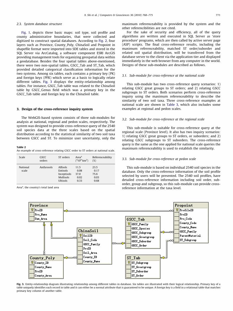
Fig. 1, depicts three basic maps: soil type, soil profile andcounty administrative boundaries, that were collected anddigitized to construct spatial databases. According to Fig. 2, fourlayers such as Province, County_Poly, ChinaSoil and Propoint inshapefile format were imported into SDE tables and stored in theSQL Server via ArcCatalog, a software component ESRI ArcGISproviding management tools for organizing geospatial data withina geodatabase. Besides the four spatial tables above-mentioned,there were two non-spatial tables, GSCC_Tab and ST_Tab, whichprovided detailed categorical classification information for thetwo systems. Among six tables, each contains a primary key (PK)and foreign keys (PFK) which serve as a basis to logically relatedifferent tables. Fig. 3 displays the entity-relationship amongtables. For instance, GSCC_Tab table was related to the ChinaSoiltable by GSCC_Genus field which was a primary key in theGSCC_Tab table and foreign key in the ChinaSoil table.
3. Design of the cross-reference inquiry system
The WebGIS-based system consists of three sub-modules foranalysis at national, regional and pedon scales, respectively. Thesystem was designed to provide cross-reference query of the 2540soil species data at the three scales based on the spatialdistribution according to the statistical similarity of two soil taxabetween GSCC and ST. To minimize user uncertainty, only the
Table 2An example of cross-reference relating GSCC order to ST orders at national scale.
Scale GSCC
orders
ST orders Areax
(n104 km2)
Referenceability
(%)
National
scale
Anthrosols Alfisols 11.5 23.5
Entisols 0.08 0.17
Inceptisols 37.0 75.6
Mollisols 0.02 0.03
Ultisols 0.33 0.68
Areax, the country’s total land area
Fig. 3. Entity-relationship diagram illustrating relationship among different tables in d
table uniquely identifies each record in table and it can either be a normal attribute that
primary key column of another table.
maximum referenceability is provided by the system and theother referencibilities are not cited.
For the sake of security and efficiency, all of the queryalgorithms are written and executed in SQL Server as ‘storeprocedure’ programs, which are then called by active server page(ASP) scripts. The final cross-reference results, including themaximum referenceability, matched ST order/suborder andrelated soil spatial distribution, will be transferred from thedatabase server to the client via the application tier and displayedimmediately in the web browser from any computer in the world.Designs of these sub-modules are described as follows.
3.1. Sub-module for cross-reference at the national scale
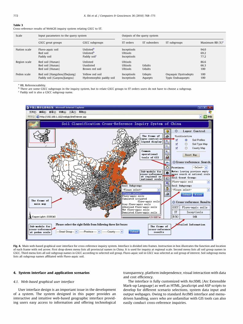
This sub-module has two cross-reference query scenarios: 1)relating GSCC great groups to ST orders; and 2) relating GSCCsubgroups to ST orders. Both scenarios perform cross-referenceinquiry using the maximum referenceability to describe thesimilarity of two soil taxa. Three cross-reference examples atnational scale are shown in Table 3, which also includes someexamples at regional and pedon scales.
3.2. Sub-module for cross-reference at the regional scale
This sub-module is suitable for cross-reference query at theregional scale (Province level). It also has two inquiry scenarios:1) relating GSCC great groups to ST orders, or suborders; and 2)relating GSCC subgroups to ST suborders. The cross-referencequery is the same as the one applied for national scale queries themaximum referenceability is used to establish the similarity.
3.3. Sub-module for cross-reference at pedon scale
This sub-module is based on individual 2540 soil species in thedatabase. Only the cross-reference information of the soil profileselected by users will be presented. The 2540 soil profiles, havedetailed cross-reference information including soil order, sub-order, group and subgroup, so this sub-module can provide cross-reference information at the taxa level.
atabase. Six tables are illustrated with their logical relationship. Primary key of a
is guaranteed to be unique. A foreign key is a field in a relational table that matches
ARTICLE IN PRESS
Table 3Cross-reference results of WebGIS inquiry system relating GSCC to ST.
Scale Input parameters to the query system Outputs of the query system
GSCC great groups GSCC subgroups ST orders ST suborders ST subgroups Maximum RB (%)a
Nation scale Fluvo-aquic soil Unlistedb Inceptisols 94.0
Red soil Unlistedb Ultisols 69.2
Paddy soil Paddy soilc Inceptisols 77.2
Region scale Red soil (Hunan) Unlisted Ultisols 86.6
Red soil (Hunan) Uunlisted Ultisols Udults 66.3
Red soil (Hunan) Brown red soil Ultisols Udults 100
Pedon scale Red soil (Hangzhou/Zhejiang) Yellow red soil Inceptisols Udepts Oxyaquic Dystrudepts 100
Paddy soil (Gaoyou/Jiangsu) Hydromorphic paddy soil Inceptisols Aquepts Typic Endoaquepts 100
a RB, Referenceability.b There are some GSCC subgroups in the inquiry system, but to relate GSCC groups to ST orders users do not have to choose a subgroup.c Paddy soil is also a GSCC subgroup name.
Fig. 4. Main web-based graphical user interface for cross-reference inquiry system. Interface is divided into frames. Instruction in box illustrates the function and location
of each frame with red arrow. First drop-down menu lists all provincial names in China. It is used for inquiry at regional scale. Second menu lists all soil group names in
GSCC. Third menu lists all soil subgroup names in GSCC according to selected soil group. Fluvo-aquic soil in GSCC was selected as soil group of interest. Soil subgroup menu
lists all subgroup names affiliated with Fluvo-aquic soil.
X. Shi et al. / Computers & Geosciences 36 (2010) 768–775772
4. System interface and application scenarios
4.1. Web-based graphical user interface
User interface design is an important issue in the developmentof a system. The system designed in this paper provides aninteractive and intuitive web-based geographic interface provid-ing users easy access to information and offering technological
transparency, platform independence, visual interaction with dataand cost efficiency.
The interface is fully customized with ArcXML (Arc ExtensibleMark-up Language) as well as HTML, JavaScript and ASP scripts todevelop for different scenario selections, system data input andoutput webpages. Owing to standard ArcIMS interface and menu-driven handling, users who are unfamiliar with GIS tools can alsoeasily conduct cross-reference inquiries.
ARTICLE IN PRESS
X. Shi et al. / Computers & Geosciences 36 (2010) 768–775 773
As shown in Fig. 4, the main interface contains a series offrames for: 1) viewing maps and soil spatial distributioninformation; 2) manipulating maps with universal GIS toolssuch as ‘overview map’, ‘zoom in’, ‘zoom out’, ‘pan’, ‘identify’, ‘SQLquery’, ‘print map’, etc.; 3) controlling different map layers ordisplaying legend; 4) running the cross-reference sub-modules forregional or national scale analyses; 5) running the cross-referencesub-module for pedon scale analysis; and 6) presenting cross-reference results. Users can easily interact with the contents ofthe database or run sub-models by clicking buttons, to generatetheir own inquiry results. More specific descriptions of howapplying the inquiry system are presented below.
4.2. Scenario 1: cross-reference inquiry at the national scale
This paragraph illustrates the specific cross-reference inquiryprocesses. The inquiry parameters can be easily obtained from theWebGIS-based system by clicking one or two options from theinteractive interface. As shown in Fig. 4 above, there are two drop-down menus located in middle position of left side, one contain-ing all GSCC great group names and the other the subgroup namesaccording to the selected soil group.
For example, if Fluvo-aquic soil in GSCC was selected in the‘great group’ drop-down menu, six subgroups of Fluvo-aquic soilwould be listed on the ‘subgroups’ drop-down menu. If one greatgroup was only chosen while leaving subgroup blank, the systemwill relate GSCC great group to ST order. As seen in the figure thesystem related Fluvo-aquic soil to Inceptisols of ST withthe maximum referenceability of 94.0% at the national scale.Accordingly, the spatial distribution of Fluvo-aquic soil at washighlighted on map viewing frame of user interface (Fig. 4).Otherwise, if ‘subgroups’ drop-down menu was assigned a value
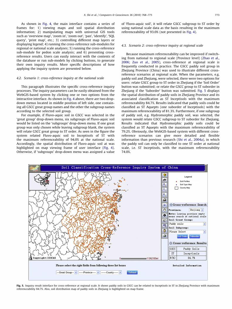
Fig. 5. Inquiry result interface for cross-reference at regional scale. It shows paddy soi
referenceability 84.7%. Also, soil distribution map of paddy soils in Zhejiang is highligh
of ‘Fluvo-aquic soil’, it will relate GSCC subgroup to ST order byusing national scale data as the basis resulting in the maximumreferenceability of 93.0% (not presented in Fig. 4).
4.3. Scenario 2: cross-reference inquiry at regional scale
Because maximum referenceability can be improved if switch-ing from national to regional scale (Province level) (Zhao et al.,2006; Zuo et al., 2005), cross-reference at regional scale isfrequently conducted in practice. The GSCC paddy soil group inZhejiang Province (China) was used to illustrate different cross-reference scenarios at regional scale. When the parameters, e.g.paddy soil and Zhejiang, were selected, there were two options forusers: relate GSCC group to ST order in Zhejiang if the ‘Soil Order’button was submitted; or relate the GSCC group to ST suborder inZhejiang if the ‘Suborder’ button was submitted. Fig. 5 displaysthe spatial distribution of paddy soils in Zhejiang Province and itsassociated classification as ST Inceptisols with the maximumreferenceability 84.7%. Results indicated that paddy soils could beclassified as ST Aquepts (one suborder of Inceptisols) with themaximum referenceability of 81.3%. Furthermore, if one subgroupof paddy soil, e.g. Hydromorphic paddy soil, was selected, thesystem would relate GSCC subgroup to ST suborder for Zhejiang.Results indicated that Hydromorphic paddy soils could beclassified as ST Aquepts with the maximum referenceability of79.2%. Obviously, the WebGIS-based system with different cross-reference scenarios can give more detailed and flexibleinformation than previous research (Shi et al., 2004a), in whichthe paddy soil can only be classified to one ST order at nationalscale, i.e. ST Inceptisols, with the maximum referenceability74.0%.
ls in GSCC can be related to Inceptisols in ST in Zhejiang Province with maximum
ted on map frame.
ARTICLE IN PRESS
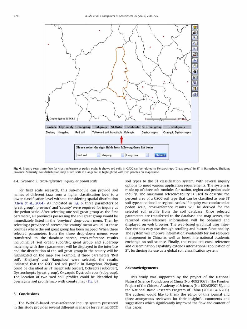
Fig. 6. Inquiry result interface for cross-reference at pedon scale. It shows red soils in GSCC can be related to Dystrochrept (Great group) in ST in Hangzhou, Zhejiang
Province. Similarly, soil distribution map of red soils in Hangzhou is highlighted with two profiles on map frame.
X. Shi et al. / Computers & Geosciences 36 (2010) 768–775774
4.4. Scenario 3: cross-reference inquiry at pedon scale
For field scale research, this sub-module can provide soilnames of different taxa from a higher classification level to alower classification level without considering spatial distribution(Chen et al., 2004). As indicated in Fig. 6, three parameters of‘great group’, ‘province’ and ‘county’ were required for inquiry atthe pedon scale. After selecting one soil great group as the firstparameter, all provinces possessing the soil great group would beimmediately listed in the ‘province’ drop-down menu. Then byselecting a province of interest, the ‘county’ menu would list thosecounties where the soil great group has been mapped. When threeselected parameters from the three drop-down menus weretransferred to the database server, cross-reference resultsincluding ST soil order, suborder, great group and subgroupmatching with those parameters will be displayed in the interfaceand the distribution of the soil great group in the county will behighlighted on the map. For example, if three parameters ‘Redsoil’, ‘Zhejiang’ and ‘Hangzhou’ were selected, the resultsindicated that the GSCC red soil profile in Hangzhou, Zhejiangcould be classified as ST Inceptisols (order), Ochrepts (suborder),Dystrochrepts (great group), Oxyaquic Dystrochrepts (subgroup).The location of two ‘Red soil’ profiles could be identified byoverlaying soil profile map with county map (Fig. 6).
5. Conclusions
The WebGIS-based cross-reference inquiry system presentedin this study provides several different scenarios for relating GSCC
soil types to the ST classification system, with several inquiryoptions to meet various application requirements. The system ismade up of three sub-modules for nation, region and pedon scaleinquiry. The maximum referenceability is used to describe thepercent area of a GSCC soil type that can be classified as one STsoil type at national or regional scales. If inquiry was conducted atpedon scale, cross-reference results will be derived for theselected soil profile from the soil database. Once selectedparameters are transferred to the database and map server, thereturned cross-reference information will be obtained anddisplayed on web browser. The web-based graphical user inter-face enables easy use through scrolling and button functionality.The system will improve information availability for soil resourcemanagement in China as well as boost international academicexchange on soil science. Finally, the expedited cross referenceand dissemination capability extends international application ofST, furthering its use as a global soil classification system.
Acknowledgements
This study was supported by the project of the NationalNatural Science Foundation of China (No. 40921061), The FrontierProject of the Chinese Academy of Sciences (No. ISSASIP0715), andthe National Basic Research Program of China (2007CB407206).The authors would like to thank the editor of this journal andthree anonymous reviewers for their insightful comments andsuggestions which significantly improved the flow and content ofthis paper.
ARTICLE IN PRESS
X. Shi et al. / Computers & Geosciences 36 (2010) 768–775 775
References
Carre, F., Jacobson, M., 2009. Numerical classification of soil profile data usingdistance metrics. Geoderma 148, 336–345.
Chang, Y.S., Park, H.D., 2004. Development of a web-based geographic informationsystem for the management of borehole and geological data. Computers &Geosciences 30, 887–897.
Chen, Z.C., Gong, Z.T., Zhang, G.L., Zhao, W.J., 2004. Correlation of soil taxa betweenChinese Soil Genetic Classification and Chinese Soil Taxonomy on variousscales. Soils (in Chinese) 36 (6), 584–595.
Eswaran, H., Rice, T., Ahrens, R., Stewartm, B.A., 2003. Soil Classification, a GlobalDesk Reference. CRC Press, Washington, DC, pp 1–263.
Ellis, E.A., Nair, P.K.R., Jeswani, S.D., 2005. Development of a web-based applicationfor agroforestry planning and tree selection. Computers and Electronics inAgriculture 49, 129–141.
Gao, P., Shi, X.Z., Yu, D.S., Wang, H.J., Sun, W.X., Zhao, Y.C., 2008. A WebGIS-basedChina soil information inquiry system. Soils (in Chinese) 40 (1), 9–15.
Gong, Z.T., Chen, Z.C., Zhao, W.J., Shi, H., 2000. Classification of ferrallitic soils inChinese soil taxonomy. Pedosphere 10 (2), 125–133.
Guo, Z.X., Li, P.J., Wen, Y., Deng, N.R., Li, X.D., 2006. Share of soil resources informationby WebGIS. Ecology and Environment (in Chinese) 15 (4), 827–830.
Huang, C.H., Chuang, T.R., Deng, D.P., Lee, H.M., 2009. Building GML-native web-based geographic information systems. Computers & Geosciences 35 (9),1802–1816.
IUSS Working Group WRB, 2006. Background to the world reference base for soilresources. In: World reference base for soil resources 2006, World SoilResources Report No.103, FAO(Food and Agriculture Organization of theUnited Nations), Rome, pp 1–9.
Jia, Y.W., Zhao, H.L., Niu, C.W., Jiang, Y.Z., Gan, H., Xing, Z., Zhao, X.L., Zhao, Z.X., 2009. AWebGIS-based system for rainfall-runoff prediction and real-time waterresources assessment for Beijing. Computers & Geosciences 35, 1517–1528.
Minasny, B., McBratney, A.B., Hartemink, A.E., 2009. Global pedodiversity,taxonomic distance, and the World Reference Base. Geoderma, doi:10.1016/j.geoderma.2009.04.024.
The Office for the Second National Soil Survey of China, 1993. Soil Species of China,I. Chinese Agriculture Press, Beijing 924pp.
The Office for the Second National Soil Survey of China, 1994a. Soil Species ofChina, II. Chinese Agriculture Press, Beijing 739pp.
The Office for the Second National Soil Survey of China, 1994b. Soil Species ofChina, III. Chinese Agriculture Press, Beijing 744pp.
The Office for the Second National Soil Survey of China, 1995a. Soil Map of People’sRepublic of China. Mapping Press, Xi’an 60pp.
The Office for the Second National Soil Survey of China, 1995b. Soil Species ofChina, IV. Chinese Agriculture Press, Beijing 806pp.
The Office for the Second National Soil Survey of China, 1995c. Soil Species ofChina, V. Chinese Agriculture Press, Beijing 886pp.
The Office for the Second National Soil Survey of China, 1996. Soil Species of China,VI. Chinese Agriculture Press, Beijing 880pp.
Panos, P., Marc, V.L., Luca, M., Robert, J.A.J., 2008. Soil organic carbon contentindicators and web mapping applications. Environmental Modelling &Software 23, 1207–1209.
Pessina, V., Meroni, F., 2009. A WebGIS tool for seismic hazard scenarios and riskanalysis. Soil Dynamics and Earthquake Engineering 29, 1274–1281.
Rao, M., Fan, G.L., Thomas, J., Cherian, G., Chudiwale, V., Awawdeh, M., 2007. Aweb-based GIS decision support system for managing and planning USDA’sConservation Reserve Program (CRP). Environmental Modelling & Software 22,1270–1280.
Research Group and Cooperative Research Group on Chinese Soil Taxonomy, 2001.Chinese Soil Taxonomy. Science Press, Beijing, pp 1–203.
Scalenghe, R., Ferraris, S., 2009. The first forty years of a Technosol. Pedosphere 19(1), 40–52.
Shi, X.Z., Gong, Z.T., 1996. Reference comparison of soil types in southeast Chinaunder different soil classifications. Chinese Journal of Soil Science (in Chinese)27 (3), 97–102.
Shi, X.Z., Yu, D.S., Sun, W.X., Wang, H.J., Zhao, Q.G., Gong, Z.T., 2004a. Referencebenchmarks relating great groups of Genetic Soil Classification of China to SoilTaxonomy. Chinese Science Bulletin 49 (13), 1299–1303.
Shi, X.Z., Yu, D.S., Warner, E.D., Pan, X.Z., Petersen, G.W., Gong, Z.G., Weindorf, D.C.,2004b. Soil database of 1:1,000,000 digital soil survey and reference system ofthe Chinese Genetic Soil Classification System. Soil Survey Horizons 45 (4),129–136.
Shi, X.Z., Yu, D.S., Warner, E.D., Sun, W.X., Petersen, G.W., Gong, Z.T., 2006a.Cross- reference system for translating between Genetic Soil Classificationof China and Soil Taxonomy. Soil Science Society of America Journal 70 (1),78–83.
Shi, X.Z., Yu, D.S., Yang, G.X., Wang, H.J., Sun, W.X., Du, G.H., Gong, Z.T., 2006b.Cross-reference benchmarks for correlating the Genetic Soil Classification ofChina and Chinese Soil Taxonomy. Pedosphere 16 (2), 147–153.
Shi, X.Z., Yu, D.S., Xu, S.X., Warner, E.D., Wang, H.J., Sun, W.X., Zhao, Y.C., Gong, Z.T.,2010. Cross-reference for relating Genetic Soil Classification of China withWRB at different scales. Geoderma 155, 344–350.
Soil Survey Staff in USDA, 2006. Keys to Soil Taxonomy. 10th Ed. U.S. GovernmentPrinting Office, Washington, DC 338 pp.
Wang, X.H., Homer, M., Dyer, S.D., White-Hull, C., Du, C.M., 2005. A river waterquality model integrated with a web-based geographic information system.Journal of Environmental Management 75, 219–228.
Wu, S.H., Jiang, C.A., Dai, J., Hu, Y.M., Liang, Z.L., 2002. Application of WebGIS in soilinformation system of Guangdong province. Journal of South China Agricul-tural University (in Chinese) 23 (2), 15–17.
Xi, C. F. (ed.). 1998. Soils of China (in Chinese). China Agriculture Press, Beijingpp 1–1253.
Zhang, J.L., Xia, B., Xiong, W.D., 2007. Designing and realization of a J2EE/ArcIMSbased Guangdong soil information publishing system. Soils (in Chinese) 39 (4),652–657.
Zhao, Y.C., Shi, X.Z., Weindorf, D.C., Yu, D.S., Sun, W.X., Wang, H.J., 2006. Map scaleeffects on soil organic carbon stock estimation in North China. Soil ScienceSociety of America Journal 70, 1377–1386.
Zuo, W., Zhou, H.Z., Zhu, X.H., Wang, Q., Wang, W.J., Wu, X.Q., 2005. Integratedevaluation of ecological security at different scales using remote sensing: acase study of Zhongxian County, the Three Gorges area, China. Pedosphere 15(4), 456–464.