a walker’s guide - stratford luxury mountain resort ... staying in ying in taranaki ta r anaki...
TRANSCRIPT
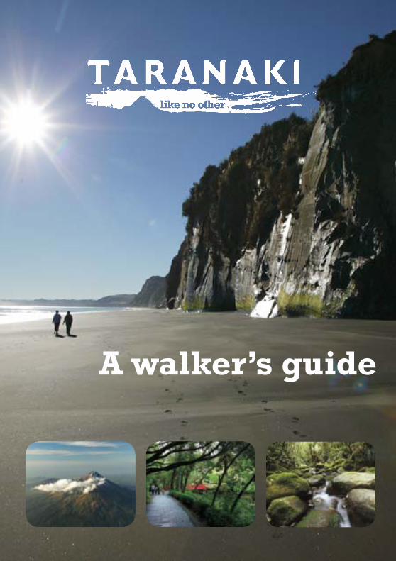
A walker’s guide

Walk TaranakiWELCOME
Taranaki boasts magnificent gardens, the iconic Mt Taranaki, a spectacular national park, three marine reserves, iron sand beaches fringed with great surf, wonderful lakes, a vibrant art and cultural scene, gourmet cafes and restaurants, museums and galleries, and a range of activities for those with a sense of fun and adventure.
A network of delightful walking tracks and pathways provides visitors with a link between these many attractions, and a unique perspective of the dramatic Taranaki landscape.
These trails offer you the chance to escape the hustle and bustle of urban life and help you discover some of the region’s many reserves, parks, areas of historical interest and natural beauty. In this booklet we highlight some of the best scenic tracks and pathways the region has to offer, from exploring the alpine splendour of the Wilkies Pools Track or meandering along one of our district coastal paths. Discovering Taranaki by foot will give you an experience like no other.
Walk Taranaki
HOW TO GET TO TARANAKI
How
to G
et to
Taranak
i
By air, land or sea, Taranaki is an accessible region neatly poised halfway between Auckland and Wellington on the western seaboard of New Zealand’s North Island.
By AirAir New Zealand flies direct to New Plymouth from Auckland or Wellington daily. The direct 45 minute flight will reaffirm your decision to visit Taranaki. Centred around a picture-perfect mountain, the lush regional countryside fertilised by countless eruptions over the centuries is simply stunning on a perfect day, framed on three sides by the endless Tasman Sea fingering the coastline with world-renowned surf swells. If you are in the South Island Air New Zealand flies direct from Christchurch to New Plymouth Monday to Friday, the flight takes approximately 90 minutes.
By RoadThere are two main arterial routes into Taranaki. From the north State Highway 3 brings you along the dramatic coast of North Taranaki from Te Kuiti, whilst from the south State Highway 3 converges with State Highway 1 at Sanson and brings you north through Wanganui and into Taranaki via Waitotara.
For those who are coming from the east and enjoy adventure and history, the Forgotten World Highway 43 (New Zealand’s first heritage trail) is a must. Starting in Taumarunui the 155 kilometre highway winds it way through rugged hill country to Stratford and takes approximately three hours.
Regular bus services to Taranaki operate from Auckland and Wellington and stop at points in-between.
Walk TaranakiCONTENTS
Co
nte
nts
Name of Walk (route no.) Distance Grade Of Walk Approx. TimeEgmont National Park(1) Pouakai Circuit 23.4 kms Moderate/Strenuous 2 - 3 day circuit(2) York Loop Track 7.0 kms Moderate 3 Hours(3) Potaema Track 0.6 km Easy (Barrier free) 15 - 20 mins(4) Summit Track 14 kms return Strenuous 8 - 12 Hours(5) Wilkies Pools Loop Track 2.3 kms Easy/Moderate 1 - 1.5 Hours(6) Kapuni Loop Track 2.0 kms Moderate 1 - 1.5 Hours(7) Mt Damper Falls Track 2.0 kms Easy 40 mins - 1 Hour
New Plymouth District(8) Whitecliffs Walkway 6.5 - 14 kms Moderate 4 - 7 Hours(9) Waitara Heritage Trail 6.0 kms Easy/Moderate 1.5 Hours(10) Mangati/Hickford Park 6.0 kms Moderate/Strenuous 2 - 2.5 Hours(11) Coastal Walkway 7.0 kms Easy/Moderate 1.5 - 2 Hours(12) Te Henui Walkway 5.9 kms Easy/Moderate 2 Hours (circular)(13) Tupare Gardens 1.0 km Moderate up to 2 Hours(14) Huatoki Walkway 5.0 kms Moderate/Strenuous 1.5 Hours(15) Pukekura Park 3.0 kms Easy/Moderate 1.5 Hours(16) Barrett Domain 3.0 kms Moderate/Strenuous 1 - 1.5 Hours(17) Ratapihipihi Reserve Track 1.9 kms Easy up to 1 Hour(18) Lake Mangamahoe 3 - 6 kms Strenuous 1.5 - 2 Hours(19) Araheke Bush Walk 3.0 km return Easy 2 Hours
Stratford District(20) Stratford Heritage Walkway 1.0 km Easy 30 - 40 mins(21) Carrington Walkway 3 - 9 kms Easy/Moderate 1 - 4.5 Hours(22) Cardiff Walkway 3.0 kms Moderate/Strenuous 1.5 Hours(23) Hollard Gardens 2.0 kms Easy up to 2 Hours
South Taranaki District(24) Opunake Walkway 7.0 kms Easy/Moderate 3 - 4 Hours(25) Ohawe Bch to Waihi Bch 5.0 kms Moderate 2.5 Hours return(26) Lake Rotokare 4.2 kms Easy/Moderate 1.5 - 2 Hours(27) Lake Rotorangi Hydro Walk 1.5 kms Easy 40 Mins(28) Patea River Walkway 1.5 kms Easy/Moderate 1.5 Hours
Walk
way C
lassifi cationWalk Taranaki
WALKWAY CLASSIFICATIONPathsPaths are well formed and provide for easy walking suitable for all ages and most fitness levels. Access is provided on a durable surface such as concrete, chip seal or compacted gravel. Many paths cater for people with mobility difficulties or limitations and children in mountain buggies or prams.
Short WalkShort walks are well formed and provide for up to one hours easy walking suitable for most ages and fitness levels.
Walking TrackWalking tracks cater for those who want an extended walk that takes from a few minutes to one full day return. These tracks are usually reasonably easy day trips and are required to be of a standard to enable use by relatively inexperienced visitors with a low level of backcountry skill and low level of risk. Some may be suitable for cyclists or mountain bikers as well as pedestrians.
Easy Tramping TrackThese tracks cater for less experienced trampers expecting a low risk experience in the backcountry. They will generally be multi day tramping tracks and some may be suitable for mountain bikers as well as pedestrians.
Tramping TrackThese tracks cater for backcountry adventurers including trampers, hunters, anglers and mountaineers. A few may be suitable for mountain bikers. The tracks generally follow the lie of the land and are commonly not formed. Barrier FreeBarrier free standard is where there is a demonstrated demand or significant potential use by physically disabled people. Where a track has been developed to be a barrier free standard, the facilities associated with the track including bridges, shelters, toilets and display signs should also cater for people with disabilities.Barrier free design strives to make the built environment accessible to and usable by all persons. It promotes integration and independence through design that is safe, functional and dignified for everyone.

Walk Taranaki
STAYING IN TARANAKI
Stay
ing
in T
aran
aki
There’s somewhere for everyone to lay their head in Taranaki. From international hotel chains and good value motels, to boutique hotels, lodges, bed and breakfast and quality hostels. Whether you’re after luxury, alpine, aquatic or character filled accommodation, Taranaki has it all.
Taranaki’s range of accommodation can be viewed on www.taranaki.info and for more information and bookings contact any of the region’s three i-SITEs.
i-SITE Visitor Centres
New Plymouth i-SITE Visitor Centre Puke Ariki, Ariki Street, New Plymouth Phone: +64 6 759 6060 Email: [email protected]
Stratford i-SITE Visitor Centre Miranda Street, Stratford Phone: +64 6 765 6708 0800 765 670 Email: [email protected]
South Taranaki i-SITE Visitor Centre 55 High Street, Hawera Phone: +64 6 278 8599 Email: [email protected]
Walk Taranaki TARANAKI MUST DO’S
Taranak
i Must D
o’s
1. Puke ArikiTreasure trove of Taranaki history and culture2. Taranaki Garden FestivalsHome to the Taranaki Rhododendron and Fringe Garden Festivals3. Pukekura ParkStroll the many walks of this 100-year old park4. New Plymouth Coastal WalkwayWander along the award-winning 7km walkway5. TSB Bank Festival of LightsCheck out the lights and sights at this nationally renowned festival6. Govett-Brewster Art GalleryView contemporary art at one of Australasia’s leading art galleries7. Helicopter flight over Mt TaranakiFly over Taranaki’s beloved icon8. WOMADExperience different cultures through art, music and food9. Tawhiti MuseumExplore Taranaki’s history and unique depiction of the 1860s Taranaki Land Wars10. Row Boats at Pukekura ParkTake a romantic boat trip on the park’s lake11. Wakeboarding at Lake RotorangiThe best way to see this 46km long hydro lake12. Summer concerts at the TSB Bowl of BrooklandsEnjoy a world class concert at this stunning natural amphitheatre13. Taranaki International Festival of the ArtsAn event-packed biennial arts festival14. PukeitiNew Zealand’s premier rhododendron garden set in magnificent rainforest on the slopes of Mt Taranaki15. Todd Energy New Plymouth Aquatic CentreExperience the hydroslides and wave pool16. Oakura BeachEnjoy family beach cricket or a picnic on Oakura Beach17. Windwanderer BikesFeel the sea breeze and enjoy the scenery as you ride these quirky bikes18. Forgotten World Highway 43Step back in time and journey through historical landscapes19. Whitecliffs WalkwayStroll the majestic coastline walkway with an alpine backdrop20. Surfing a Taranaki WaveSurf a barreling wave at one of Surf Highway 45’s major breaks

Hin
ts fo
r W
alke
rs
Walking is one of the most accessible pastimes; you can safely walk in towns or in the easy countryside without any specialist clothing, equipment or skills. However, if you plan to go deeper into the countryside you will be more comfortable and safe if you take a little time to prepare and follow a few simple safety instructions. If you intend to go into more remote and rugged areas, good planning and preparation is essential.
GENERAL SAFETY RULES
• Always check the weather forecast before setting off and dress for the expected weather conditions, carry extra clothing in case the unexpected happens and the weather changes.• Wear comfortable sturdy footwear suitable for walking.• Tell someone where you are going and when you expect to return.• Remember, if the walk you are going on is one way only, allow time and energy for your return leg.• Make sure you have plenty to eat and drink.
ENVIROMENT CARE
• Respect the plants, wildlife and the natural environment.• Have consideration for others.• Remove all rubbish you take with you or use the rubbish bins provided.• Never light fires.• Take only photographs and memories.
Walk TaranakiHINTS FOR WALKERS HINTS FOR WALKERS
PERSONAL SAFETY
• Check for tides for some of the coastal walks and where paths cross river mouths. It is essential that you check the tide tables before you leave.• Avoid using river walks during times of or forecasted heavy rain as flooding may occur.• Don’t walk alone, particularly in bush or secluded areas.• You should not walk in remote areas without a good basic knowledge of first aid. At least one person in a party should know how to bandage an ankle or apply a splint to a broken limb, be able to recognise the signs of hypothermia or heat exhaustion and know how to respond.• Always carry a first aid kit. Ready- made first aid kits are available from many of the outdoor shops.• The fundamental rule of first aid is warmth, rest and reassurance.• In cold weather the greatest danger is hypothermia or exposure. To avoid it make sure you have enough warm clothing, extra food and plenty of water. In warm weather, the main hazards are sunburn, windburn and dehydration. Sun hats, sunscreen and water can prevent serious sunburn or heatstroke.
Don’t underestimate the amount of water that you will need. It is recommended drinking 1.5 – 2 litres of water a day for an active lifestyle and you will need more if you are walking strenuously and/or if the weather is hot.
Hin
ts fo
r W
alke
rs

The Pouakai Circuit displays centuries of volcanic activity with the active erosion scar of the Boomerang slip, the towering columns of the Dieffenbach cliffs and the red water of the Kokowai Stream caused by manganese oxide oozing from the earth. The circuit takes you through the fragile Ahukawakawa Swamp, golden tussocks, summer flowers and the Stony River’s Bells Falls. Gnarled trees bent to the will of the weather line the track.
Route DescriptionNorth Egmont Visitor Centre to Holly Hut (Time: 3 hr)From the Camphouse, the well formed track steadily climbs through montane forest and sub-alpine scrub. You’ll have excellent views of the Waiwhakaiho and Kokowai river gorges, Ahukawakawa wetland and the upper slopes of Mt Taranaki as the track gradually descends to Holly Hut. Holly Hut to Pouakai Hut (Time: 2 - 3 hr) The Ahukawakawa track crosses an extensive wetland. Rest at the viewing platform to appreciate the full benefits of this major wetland. It crosses the Stony River and ascends the ridge through sub-alpine and mountain cedar to join with the Pouakai and Mangorei track junction and a short descent to Pouakai Hut. Breath taking views of the North Taranaki coastline greet you atop of the range.
Pouakai Hut to North Egmont Visitor Centre (Time: 4.5 hr)From Pouakai Hut, the Pouakai track traverses open tussock lands and sub-alpine forest to the top of Henry Peak. Take advantage of the viewing platform to gaze down over the Taranaki ring plain, Ahukawakawa swamp and across to the northern slopes of the mountain.
The track then descends into mixed kamahi forest to the Kaiauai shelter, which can be used to shelter from the elements if the Kaiauai stream is flooded and can’t be crossed.
After crossing the stream, the track traverses some deep gullies before the swingbridge over the Waiwhakaiho River.
You can then take the shorter track to Kaiauai car park on Egmont Road or follow the Ram Track up to the North Egmont Visitor Centre.
The track is steep and muddy in places with tree roots and embedded rocks. Some streams are not bridged and weather in this area is changeable and difficult to predict.
RO
UT
E 1
Distance: 23.4 kmsGrade of walk: Moderate/StrenuousTime: 2-3 day circuit
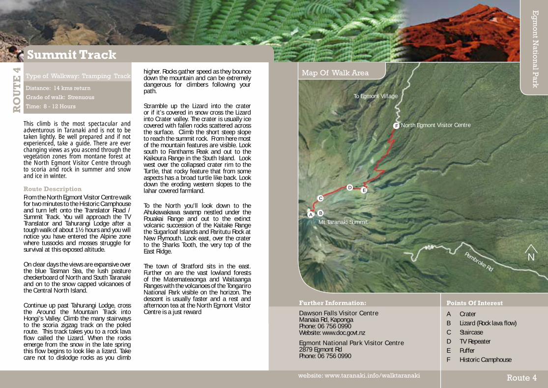
Type of Walkway: Tramping Track
Pouakai Circuit
Further Information:
Dawson Falls Visitor CentreManaia Rd, KapongaPhone: 06 756 0990Website: www.doc.govt.nz
Egmont National Park Visitor Centre2879 Egmont RdPhone: 06 756 0990
Map Of Walk Area
Route 1website: www.taranaki.info/walktaranaki
Eg
mo
nt N
ation
al Park
Points Of Interest
A Pouakai HutB TarnC Kaiauai ShelterD Kokowai Stream–Ochre deposits E Holly HutF Ahukawakawa Swamp
N
A B
C
D
E
F
North Egmont Visitor Centre
Mt Taranaki Summit
To E
gmon
t Vill
age
Egm
ont R
d

York Loop track is within Egmont National Park and follows part of the old Egmont Branch Railway Line (that evolved in 1901) which was constructed to provide metal for roads and rocks for Port Taranaki. It carried rock from mountain quarries for use on Taranaki’s roads and railways and the breakwater at the port of New Plymouth. The quarry operated until the late 1920’s. The York Rd Railway was an industrious place. House sites, crusher remains, waterlines sand trap and culverts can still be seen.
Route DescriptionTurn left 100 metres up the track from the park boundary. On approaching the Crusher site take a two minute detour to visit the site of the bunk houses and cottages.
Return and walk past the old crusher site where the massive retaining wall remains. It was part of the building that housed the crushing machine and other works. Continue over the footbridge and follow the old railway embankments and water pipeline to view the sand trap. On the way you’ll see the rusting remains of the old waterline. The sand trap is still semi operational and you will see the old valves.
Follow the track to the embankment and then turn left. A little further on the first sidetrack on your left takes in the river quarry where line segments are still visible. The second sidetrack takes you part way to the middle quarry which was closed after flooding. A large pile of spoiled rock can still be found there.
Return to the fork and turn left and continue to the footbridge and a large clearing known as the foot station. You’ll pass old water flumes and culverts along the way. The foot station was the end of the railway line and the clearing was once a rail yard. A ropeway was planned to an upper mountain quarry but access remained by foot and horse drawn wagons on rails. The track returns to the starting point via the old service road.
RO
UT
E 2
Distance: 7 kms
Grade of walk: Moderate
Time: 3 Hours
Type of Walkway: Walking Track
York Loop Track
Points Of Interest
A Barrack SiteB Crusher SiteC SandtrapD Foot Station
Further Information:
Dawson Falls Visitor CentreManaia Rd, KapongaPhone: 06 756 0990Website: www.doc.govt.nz
Egmont National Park Visitor Centre2879 Egmont RdPhone: 06 756 0990
Map Of Walk Area
Eg
mo
nt N
ation
al Park
Route 2website: www.taranaki.info/walktaranaki
N
A
B
CD
To Stratford
To East Egmont carpark
Surrey R
d
Derby Rd
Barc
lay
Rd

This barrier free track starts at the Potaema Picnic Area about 3km in from the park boundary on Pembroke Road. Suited to families, wheel chairs, push chairs, disabled, aged and short stop travellers this track truly exhibits a rain forest environment lush with its hanging gardens and carpets of moss and ferns dwarfed by its towering forest. On a fine day witness from the viewing platform at the end of the track the origins of its name: Potae (hat) ma (top or white); depicted by the magnificent view to be had of the mountain towering over the swamp. Potaema is the closest of the lowland mires in the Park and has the greatest variety of vegetation. No matter the time of the year, Potaema will display an array of flowering plants, native birds, and insects catching the interest of inquisitive visitors.
Route DescriptionEast Egmont is at the end of this road but begin this track from the Potaema picnic area, 2km in from the Park boundary on the left side of Pembroke Road. The track leads to a large lowland mire (bog) that sustains a wide variety of flora and fauna. You’ll pass through lush lowland forest made up of rimu-rata, kamahi, kahikatea, mountain totara, pokaka and a few pahautea or mountain cedar. These trees thrive in the rich fertile conditions.
Magnificent views of the mountain can be seen across the swamp from the viewing area.
RO
UT
E 3
Distance: 600 metres
Grade of walk: Easy (barrier free)
Time: 15 - 20 Minutes
Type of Walkway: Walking Track
Potaema Track
Points Of Interest
A Potaema Swamp B Lowland Forest C Potaema Picnic AreaD Carpark
Further Information:
Dawson Falls Visitor CentreManaia Rd, KapongaPhone: 06 756 0990Website: www.doc.govt.nz
Egmont National Park Visitor Centre2879 Egmont RdPhone: 06 756 0990
Map Of Walk Area
Eg
mo
nt N
ation
al Park
Route 3website: www.taranaki.info/walktaranaki
N
A
Potaema Swamp
Pembroke Rd
To Stratford
BC
D
T
This climb is the most spectacular and adventurous in Taranaki and is not to be taken lightly. Be well prepared and if not experienced, take a guide. There are ever changing views as you ascend through the vegetation zones from montane forest at the North Egmont Visitor Centre through to scoria and rock in summer and snow and ice in winter.
Route DescriptionFrom the North Egmont Visitor Centre walk for two minutes to the Historic Camphouse and turn left onto the Translator Road / Summit Track. You will approach the TV Translator and Tahurangi Lodge after a tough walk of about 1½ hours and you will notice you have entered the Alpine zone where tussocks and mosses struggle for survival at this exposed altitude. On clear days the views are expansive over the blue Tasman Sea, the lush pasture checkerboard of North and South Taranaki and on to the snow capped volcanoes of the Central North Island. Continue up past Tahurangi Lodge, cross the Around the Mountain Track into Hongi’s Valley. Climb the many stairways to the scoria zigzag track on the poled route. This track takes you to a rock lava flow called the Lizard. When the rocks emerge from the snow in the late spring this flow begins to look like a lizard. Take care not to dislodge rocks as you climb
higher. Rocks gather speed as they bounce down the mountain and can be extremely dangerous for climbers following your path. Scramble up the Lizard into the crater or if it’s covered in snow cross the Lizard into Crater valley. The crater is usually ice covered with fallen rocks scattered across the surface. Climb the short steep slope to reach the summit rock. From here most of the mountain features are visible. Look south to Fanthams Peak and out to the Kaikoura Range in the South Island. Look west over the collapsed crater rim to the Turtle, that rocky feature that from some aspects has a broad turtle like back. Look down the eroding western slopes to the lahar covered farmland. To the North you’ll look down to the Ahukawakawa swamp nestled under the Pouakai Range and out to the extinct volcanic succession of the Kaitake Range the Sugarloaf Islands and Paritutu Rock at New Plymouth. Look east, over the crater to the Sharks Tooth, the very top of the East Ridge. The town of Stratford sits in the east. Further on are the vast lowland forests of the Matemateaonga and Waitaanga Ranges with the volcanoes of the Tongariro National Park visible on the horizon. The descent is usually faster and a rest and afternoon tea at the North Egmont Visitor Centre is a just reward
RO
UT
E 4
Distance: 14 kms return
Grade of walk: Strenuous
Time: 8 - 12 Hours
Type of Walkway: Tramping Track
Summit Track
Points Of Interest
A Crater B Lizard (Rock lava flow) C StaircaseD TV RepeaterE PufferF Historic Camphouse
Further Information:
Dawson Falls Visitor CentreManaia Rd, KapongaPhone: 06 756 0990Website: www.doc.govt.nz
Egmont National Park Visitor Centre2879 Egmont RdPhone: 06 756 0990
Map Of Walk Area
Eg
mo
nt N
ation
al Park
Route 4website: www.taranaki.info/walktaranaki
N
B
C
DE
F
Mt Taranaki Summit
North Egmont Visitor Centre
To Egmont Village
Pembroke Rd
A

T
This is a loop track that will probably take you longer if you stop to enjoy the water or views. You begin and end on the same track above the Dawson Falls Visitor Centre. It is possible to avoid the loop and return the same way, but not as interesting. It takes you to a series of pools formed by the scouring action of water-borne sand and gravel on 20,000 year old lava. They are well worth the walk.
Route DescriptionThe track begins from the car park 100m above the Dawson Falls Visitor Centre. Walk through the “goblin forest” of twisted kamahi trunks hanging with ferns and mosses. Walk straight ahead and past two seats strategically located for visitors to sit and absorb the surrounding forest.
Cross the Kapuni Stream. Take care here as the river bank may be eroded, making access difficult. There is no bridge across this stream. Continue to walk through the sub alpine scrub to Wilkies Pools where the Kapuni Stream water carves and sculptures natural channels and plunge pools in the old lava flow. Some wooden steps encourage you to go a little further to where the track ends in a wide river valley. Return to the base of the pools to continue the walk.
The rest of the loop leads through sub alpine scrub, montane forest past Twin Falls and Bubbling Springs.
Walk past the road end water intake weir, cross the Kapuni Stream and turn left at the seat to return to the parking area.
RO
UT
E 5
Distance: 2.3 kms
Grade of walk: Easy/Moderate
Time: 1 - 1.5 Hours
Type of Walkway: Walking Track
Wilkies Pools Loop Track
Points Of Interest
A Lookout B Wilkies Pools C Twin Falls D Bubbling SpringsE Weir F Dawson Falls Visitor Centre
Further Information:
Dawson Falls Visitor CentreManaia Rd, KapongaPhone: 06 756 0990Website: www.doc.govt.nz
Egmont National Park Visitor Centre2879 Egmont RdPhone: 06 756 0990
Map Of Walk Area
Eg
mo
nt N
ation
al Park
Route 5website: www.taranaki.info/walktaranaki
N
B
C
D
E
Manaia Rd
A
To Kaponga
F

A
A pleasant drive to 900 metres above sea level on Mt Taranaki’s south eastern slopes brings you to Dawson Falls Roadend. This is the starting point for many walks on this side of the mountain. The Kapuni Loop track meanders its way down the true right bank of the Kapuni river where alpine plant species can be found out of their vegetation zone due to water and wind borne seed distribution. Witness this river carving its way down the ancient lava flows to Dawson falls. Make your way to your start point via Montane forest dominated by Kamahi and Totara.
Route DescriptionThe walk starts to the left of Manaia Road below the Dawson Falls Tourist Lodge. Take a 2 minute return walk to the power station is a worthwhile detour. Listen to the Kapuni Stream which drives one of world’s oldest continually operating generators. It supplies the power for the Dawson Falls Tourist Lodge and is located only 30 metres from the Lodge.
Then follow the southern bank of the Kapuni Stream through mountain rainforest to the top of Dawson Falls. A steep side-track leads down to the base of the falls but a railed viewing point on the main track provides the best overall view of the waterfall. After the viewpoint, the track winds its way up to the road.
Look for the layers of lava, pumice, gravels and ash in the bluffs flanking the waterfall then return back up to the railed lookout for the best view. Walk past the lookout and follow the track as it winds up to the road. Cross the road and enter a forest of fuchsia, kotukutuku and fern. The track leads to the clearing below Konini Lodge and a path up to your starting point.
Exercise caution when walking in the vicinity of the road and near the waterway.
RO
UT
E 6
Distance: 2 kms
Grade of walk: Moderate
Time: 1 - 1.5 Hours
Type of Walkway: Walking Track
Kapuni Loop Track
Points Of Interest
A Dawson Falls Power Station B Dawson Falls C Konini Lodge D Dawson Falls Visitor Centre
Further Information:
Dawson Falls Visitor CentreManaia Rd, KapongaPhone: 06 756 0990Website: www.doc.govt.nz
Egmont National Park Visitor Centre2879 Egmont RdPhone: 06 756 0990
Map Of Walk Area
Eg
mo
nt N
ation
al Park
Route 6website: www.taranaki.info/walktaranaki
N
B
C
D
A
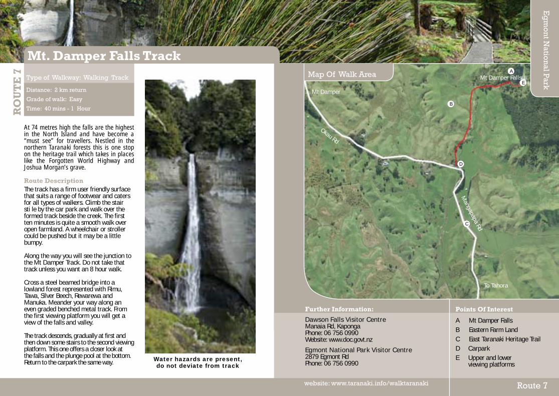
At 74 metres high the falls are the highest in the North Island and have become a “must see” for travellers. Nestled in the northern Taranaki forests this is one stop on the heritage trail which takes in places like the Forgotten World Highway and Joshua Morgan’s grave.
Route DescriptionThe track has a firm user friendly surface that suits a range of footwear and caters for all types of walkers. Climb the stair sti le by the car park and walk over the formed track beside the creek. The first ten minutes is quite a smooth walk over open farmland. A wheelchair or stroller could be pushed but it may be a little bumpy. Along the way you will see the junction to the Mt Damper Track. Do not take that track unless you want an 8 hour walk. Cross a steel beamed bridge into a lowland forest represented with Rimu, Tawa, Silver Beech, Rewarewa and Manuka. Meander your way along an even graded benched metal track. From the first viewing platform you will get a view of the falls and valley. The track descends, gradually at first and then down some stairs to the second viewing platform. This one offers a closer look at the falls and the plunge pool at the bottom. Return to the carpark the same way.
RO
UT
E 7
Distance: 2 km return
Grade of walk: Easy
Time: 40 mins - 1 Hour
Type of Walkway: Walking Track
Mt. Damper Falls Track
Points Of Interest
A Mt Damper Falls B Eastern Farm Land C East Taranaki Heritage Trail D CarparkE Upper and lower viewing platforms
Further Information:
Dawson Falls Visitor CentreManaia Rd, KapongaPhone: 06 756 0990Website: www.doc.govt.nz
Egmont National Park Visitor Centre2879 Egmont RdPhone: 06 756 0990
Map Of Walk Area
Eg
mo
nt N
ation
al Park
Route 7website: www.taranaki.info/walktaranaki
Mt Damper Falls
To Tahora
Mt Damper
Okau Rd
Mangapapa Rd
B
D
C
A
Water hazards are present, do not deviate from track
E

T
This walkway uses the Kapuni to Auckland gas pipeline route for 14 km from Pukearuhe to Tongaporutu and offers stunning views of the North Taranaki coastline and the Parininihi Marine Reserve. The laying of the pipeline involved an immense amount of heavy construction work and these operations opened up walking access to the dramatic forest and coastal country of the region. The walkway crosses open farmland (privately owned) to Mt Davidson, where it enters Ngati Tama private land. It then follows the pipeline route along the ridge tops before descending to the Waipingau Stream. Here you can divert from the track and return to Pukearuhe by following the stream to the coast (1.2 km) and walking south along the beach (tide permitting).
Route DescriptionThis walkway offers four options. At two points along the track you can follow streams to the coast and tide permitting, return to your starting point along an isolated ocean beach flanked by towering white cliffs. Or, stay on the cliff top track and cross bridged streams through farmland and forest to Mt Messenger or on to the coastal settlement of Tongaporutu. Begin at the Pukearuhe boat ramp at the end of Pukearuhe Rd. It’s just north of Urenui and near the cliff top site of an old redoubt and military settlement. Park to allow access to the ramp and farm, and
then follow the signs to the cliff top track. Cross open farmland to Mt Davidson and then follow the ridge top tracks across land of Ngati Tama, the local iwi. Descend to the Waipingau Stream, the first of the exit tracks to the beach. You can follow the stream to the coast and walk south along the beach to Pukearuhe. The round trip is 6.5 km but be aware of the tide times. There are no exit points along this beach until you are back at the boat ramp. Off the coast is the Parininihi Marine Reserve, home to a variety of fish species, large lobster populations and a colourful tangle of exotic sponges. Anglers can surf cast from the beach south of the Waipingau Stream but the beach to north is part of the reserve. The walkway continues to the Parininihi trig and then descends to the junction of the Mt Messenger Track leading to State Highway 3. This option is 11 km (up to 7hrs). The Whitecliffs Walkway now descends to private farmland where the stream mouth or the Te Horo stock tunnel provide another beach exit for a south bound beach walk back to Pukearuhe. (11 km - up to 6 hours in total). The northern boundary of Parininihi is a little further north.
The rest of the walkway follows Clifton Rd through private farmland to the sealed road at Tongaporutu. Spectacular views include the Three Sisters rock formations.
RO
UT
E 8
Distance: 6.5 - 14 kms
Grade of walk: Moderate
Time: 4 - 7 Hours
Type of Walkway: Walking Track
Whitecliffs Walkway
Points Of Interest
A Waipingau Stream B Te Horo Stock Tunnel C White Cliffs D Parininihi Marine Reserve
Further Information:
Dept. of Conservation Taranaki Area Office 55A Rimu Street, New Plymouth Ph: 06 759 0351 Web: www.doc.govt.nz
New Plymouth’s i-SITE Visitor Information Ctre65 St Aubyn St, North Wing, Puke Ariki, New Plymouth Ph: 06 759 6060 Web: www.newplymouthnz.com
Map Of Walk Area
New
Plym
outh
District
Route 8website: www.taranaki.info/walktaranaki
N
Pukearuhe
SH3
SH3
To HamiltonSH3
Clift
on R
d
Hutiwai Rd
Gilbert Rd
Mangaonga Rd
D C
A
B

The Waitara Valley has a rich and sheltered history, with the countryside scattered with evidence of fortifications reflecting a period of human occupation over many hundreds of years. With European settlement in North Taranaki occurring from 1841, conflict began to arise over the colonists attempt to gain land for cultivation. This culminated in the first Taranaki Land War in 1860-61. The town (then known as Raleigh) came into being, with Borough status achieved in 1904 when the name reverted to Waitara.
Points of InterestA Te Roimata O Te Atiawa This stone commemorates Wiremu Kingi Te Rangitaake a paramount chief of Te Atiawa at the time of the first Taranaki Land War in 1860-61. The Bridges of Waitara Bridging the Waitara River was a major challenge in early settler days but in 1871 the first pile of a bridge was driven in.Carved Panels Ten carved panels are located on the boardwalk representing the flora and fauna of Waitara. Ruamano This stone is dedicated to the many workers who (since 1880) have worked in the meat processing plant originally near this site.Waitara Pill Box The Home Guard (formed during World War II) used this to defend the area of coast between Waipapa Stream to Waiongana River.
The Works Wharves In the 1890’s two small wharves were built to service the growing freezing works industry. Railway Signal Box This originated in Stratford but was brought to Waitara in 1960 to serve as a club house for the Waitara Boating Club.River Fords These were utilised by travellers in the early days of settlement. Hurirapa Pa This was the only Pa of four in the district that was not destroyed in the early days of the first Taranaki Land War. The Return Port In 1848 Wiremu Kingi Te Rangitaake and followers returned home to occupy four new Pa on the western side of the River.The Waitara Blockhouse Kuhikuhi pa was erected here in 1848 but destroyed in 1860 to build a blockhouse at the beginning of the first Land War. The harbour pilot’s house and signal box (c. 1880) still remain here.Pukekohe Originally built as a village before 1700, Pukekohe was defended by diches, banks and palisades. Rose Garden This garden commemorates the late Mr Bob Donaldson for his long service to Waitara as a borough councillor. The Railway The New Plymouth – Waitara Railway was opened in 1875 to link New Plymouth with the nearest sheltered port. Memorial Cenotaph This monument commemorates the 78 servicemen from Waitara District who fell in the two World Wars.Aorangi Pa For several hundred years a fortified pa and settlement occupied this bluff.
RO
UT
E 9
Distance: 6 kms
Grade of walk: Easy/Moderate
Time: 1.5 Hours
Type of Walkway: Walking Track
Waitara Heritage Trail
Further Information:
New Plymouth’s i-SITE Visitor Information Ctre65 St Aubyn St, North Wing, Puke Ariki, New Plymouth Ph: 06 759 6060 Web: www.newplymouthnz.com
Map Of Walk Area
New
Plym
outh
District
Route 9website: www.taranaki.info/walktaranaki

Only minutes away from the Bell Block residential area, this beautiful walkway travels through farm land and coastal plantings. Very peaceful.
Route DescriptionFollow the track through the paddocks and sealed areas. Te Rewa RewaNgati Tawhirikura hapu have mana whenua over this historic site and surrounding area. Their lands were strategically chosen to provide a good defence mechanism with well sited lookout points for approaching enemy, access to an array of food gathering places as well as large flat areas for cultivation.
On 6th June 1887 Crown grant was issued for 504 acres, 3 roads and 36 perches known as Katere or Waiwakaiho Native reserve to members of the Ngati Tawhirikura hapu. A certificate was issued some 17 years later to the Public Trustee who administered native reserves under section 8 of the Native Reserves Act 1882. In 1905, just under 80 acres of Katere Reserve containing the historic Rewa Rewa Pa and Urupa was compulsory acquired through the Public Works Act 1905 for a rifle range.
On 4 June 2007, a joint partnership between New Plymouth District Council and Tawhirikura Hapu trust was signed.
Hickford ParkThe coastal portion of the reserve is made up expansive vegetative dunes which increase in size and height to the east. The undeveloped pathway that runs along the foreshore provides beach access to the rocky beach. Also found at this location are spring-fed wetlands at Waipu Lagoons and the artificial wetlands at the former oxidation ponds provide habitat for a number of bird and animal species. The area is one of the few remaining natural wetlands in Taranaki. The Department of Conversation has listed Waipu Lagoons as a Protected Natural area because of their wildlife values. The reserve is also a historic and cultural significance to Puketapu Hapu and within the tribal rohe of Te Atiawa Iwi. MangatiA mown and concrete pathway follows the Mangati Stream, as it narrows and winds from Bell Block to amidst residential areas. This section of walkway provides a link between residential areas and the foreshore. Future development for this walkway will be an underpass beneath SH1. Bell Block BeachBell Block beach provides beach access for water-based activities, including boat launching.
Toilets are available, dogs are permitted on this pathway and there is free parking.
RO
UT
E 1
0
Distance: 6 kms
Grade of walk: Moderate/Strenuous
Time: 2 - 2.5 Hours
Type of Walkway: Walking Track
Mangati/Hickford Park
Further Information:
New Plymouth’s i-SITE Visitor Information Ctre65 St Aubyn St, North Wing, Puke Ariki, New Plymouth Ph: 06 759 6060 Web: www.newplymouthnz.com
Map Of Walk Area
New
Plym
outh
District
Route 10website: www.taranaki.info/walktaranaki
Points Of Interest
A Te Rewa Rewa Pa site B Old rifle range and bunkers C New Plymouth Golf Club D Hickford Park Sportsfields E Waipu Lagoons
N
C
B
D
E
A
Nug
ent S
t
Parklands Ave
Mangati Rd
Ellesmere Ave

The award-winning New Plymouth Coastal Walkway is a 7km path that forms an expansive sea-edge promenade stretching almost the entire length of New Plymouth. Ideal for walking, running, cycling or skating, or simply enjoying the view of the dramatic west coast, the walkway connects popular recreational areas and the CBD to the sea. Running alongside the Tasman Sea, the Coastal Walkway stretches from the Waiwhakaiho River mouth in the east to Pioneer Park in the west and is a popular spot to take time out to enjoy the great views. With numerous pedestrian access points dotted along the way, it consists mostly of a paved pathway with a gravel section at the Waiwhakaiho end.
HistoryWork on the New Plymouth Coastal Walkway began in 1999 and formed part of a larger revival of the lower section of the city. Enhancements continue to be made, and an extension to the walkway eastward to Bell Block is planned. DesignThe New Plymouth Coastal Walkway has been designed to suit the greater coastal landscape. The design uses robust and simple materials with strong lines and textures to stand up to, and reflect upon, the character of the west coast.
The promenade is designed without an edge, to accentuate the sense of being on the edge of the sea, while the curved seawall and location of the path provide protection from the waves. The seawall is also punctured by finger piers, which are designed for people to view and enjoy the open coastline. Route DescriptionFollow the track through the paddocks and sealed areas. From the east (Lake Rotomanu), walk alongside the New Plymouth Golf Club and the Fitzroy Motor Camp, and visit surf beaches at Fitzroy and East End - all the time watching the ever-changing sea.
Leave the walkway and meander up the Te Henui Walkway, or take a break at one of the picnic tables at the East End playground. Approaching the central section of the walkway see New Plymouth District’s iconic 45 metre Wind Wand, a number of interesting stone carvings and pieces of public art, or access the central business district. Heading west, the walkway arrives at the marina at the port and Ngamotu Beach - a safe swimming beach for the family. Beyond Ngamotu Beach, a climb to the top of Paritutu Rock provides 360 degree views of the region, the Tasman Sea and the adjacent Sugar Loaf Islands.
Winner of LiveCom Sustainable
Community Project
RO
UT
E 1
1
Distance: 7 kms
Grade of walk: Easy/Moderate
Time: 1.5 - 2 Hours
Type of Walkway: Path/Short Walk
New Plymouth Coastal Walkway
Further Information:
New Plymouth’s i-SITE Visitor Information Ctre65 St Aubyn St, North Wing, Puke Ariki, New Plymouth Ph: 06 759 6060 Web: www.newplymouthnz.com
Map Of Walk Area
New
Plym
outh
District
Route 11website: www.taranaki.info/walktaranaki
Points Of Interest
A Puke Ariki B Wind wand C Govett Brewster Gallery D Honeyfield Drinking Fountain E Aquatic Centre
N
BDE
AC
Ocean View Parade
St Aubyn St
Devon St East
Vivian St
Mangorei Rd
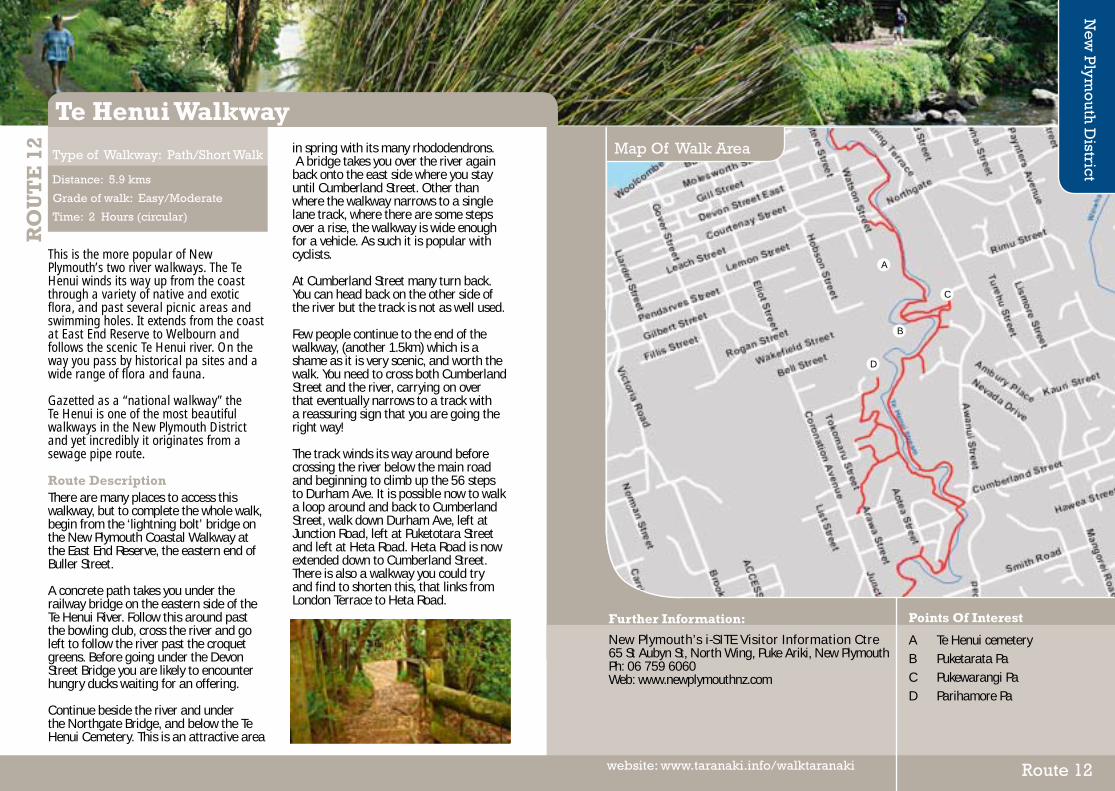
T
This is the more popular of New Plymouth’s two river walkways. The Te Henui winds its way up from the coast through a variety of native and exotic flora, and past several picnic areas and swimming holes. It extends from the coast at East End Reserve to Welbourn and follows the scenic Te Henui river. On the way you pass by historical pa sites and a wide range of flora and fauna. Gazetted as a “national walkway” the Te Henui is one of the most beautiful walkways in the New Plymouth District and yet incredibly it originates from a sewage pipe route. Route DescriptionThere are many places to access this walkway, but to complete the whole walk, begin from the ‘lightning bolt’ bridge on the New Plymouth Coastal Walkway at the East End Reserve, the eastern end of Buller Street.
A concrete path takes you under the railway bridge on the eastern side of the Te Henui River. Follow this around past the bowling club, cross the river and go left to follow the river past the croquet greens. Before going under the Devon Street Bridge you are likely to encounter hungry ducks waiting for an offering. Continue beside the river and under the Northgate Bridge, and below the Te Henui Cemetery. This is an attractive area
in spring with its many rhododendrons. A bridge takes you over the river again back onto the east side where you stay until Cumberland Street. Other than where the walkway narrows to a single lane track, where there are some steps over a rise, the walkway is wide enough for a vehicle. As such it is popular with cyclists. At Cumberland Street many turn back. You can head back on the other side of the river but the track is not as well used. Few people continue to the end of the walkway, (another 1.5km) which is a shame as it is very scenic, and worth the walk. You need to cross both Cumberland Street and the river, carrying on over that eventually narrows to a track with a reassuring sign that you are going the right way! The track winds its way around before crossing the river below the main road and beginning to climb up the 56 steps to Durham Ave. It is possible now to walk a loop around and back to Cumberland Street, walk down Durham Ave, left at Junction Road, left at Puketotara Street and left at Heta Road. Heta Road is now extended down to Cumberland Street. There is also a walkway you could try and find to shorten this, that links from London Terrace to Heta Road.
RO
UT
E 1
2
Distance: 5.9 kms
Grade of walk: Easy/Moderate
Time: 2 Hours (circular)
Type of Walkway: Path/Short Walk
Te Henui Walkway
Further Information:
New Plymouth’s i-SITE Visitor Information Ctre65 St Aubyn St, North Wing, Puke Ariki, New Plymouth Ph: 06 759 6060 Web: www.newplymouthnz.com
Map Of Walk Area
New
Plym
outh
District
Route 12website: www.taranaki.info/walktaranaki
Points Of Interest
A Te Henui cemetery B Puketarata Pa C Pukewarangi Pa D Parihamore Pa
C
A
D
B

Tupare is a beautifully sculptured landscaped garden nestled on a hillside overlooking the Waiwhakaiho River on the outskirts of New Plymouth. The property features a Chapman Taylor designed homestead and a Gardeners Cottage.Tupare was the home of Sir Russell and Lady Matthews. They brought the property in 1932 as a gorse and bracken covered hillside. You can learn about the Gardens history and the people involved from information in the Cottage and around the Garden.
At the Gatehouse there informative wayfinding information and visitor guides are available to assist you on your walk. Tupare is now owned and managed by the Taranaki Regional Council.
Route DescriptionThere are three marked trails which you can follow at Tupare:
The Boundary TrailThe Boundary Trail takes you around the perimeter of the property through huge Redwood Trees, down onto the River Flat, then up through the Bush Walk and then back through the garden. This is the most challenging walk.
The Garden WalkThe Garden Walk criss crosses through the main garden areas of Tupare, with some steeper gradients in places. There
are a number of seats to rest on and take in the scenery.
The House Stoll The House Stroll is the easiest walk of the three. Once you walk down the drive to the house area the routes here are all on the same level. You will experience some of the most popular areas of the Garden including the Elizabeth Garden (a popular garden for weddings), the Glasshouse area which encompasses some delightfully planted herbaceous borders, and of course the gardens around the house.
All of the paths on the Garden Walk and the House Stroll are asphalted.
RO
UT
E 1
3
Distance: 1 km
Grade of walk: Moderate
Time: up to 2 Hours
Type of Walkway: Path/Short Walk
Tupare Walkway
Further Information:
New Plymouth’s i-SITE Visitor Information Ctre65 St Aubyn St, North Wing, Puke Ariki, New Plymouth Ph: 06 759 6060 Web: www.newplymouthnz.com
Map Of Walk Area
New
Plym
outh
District
Route 13website: www.taranaki.info/walktaranaki
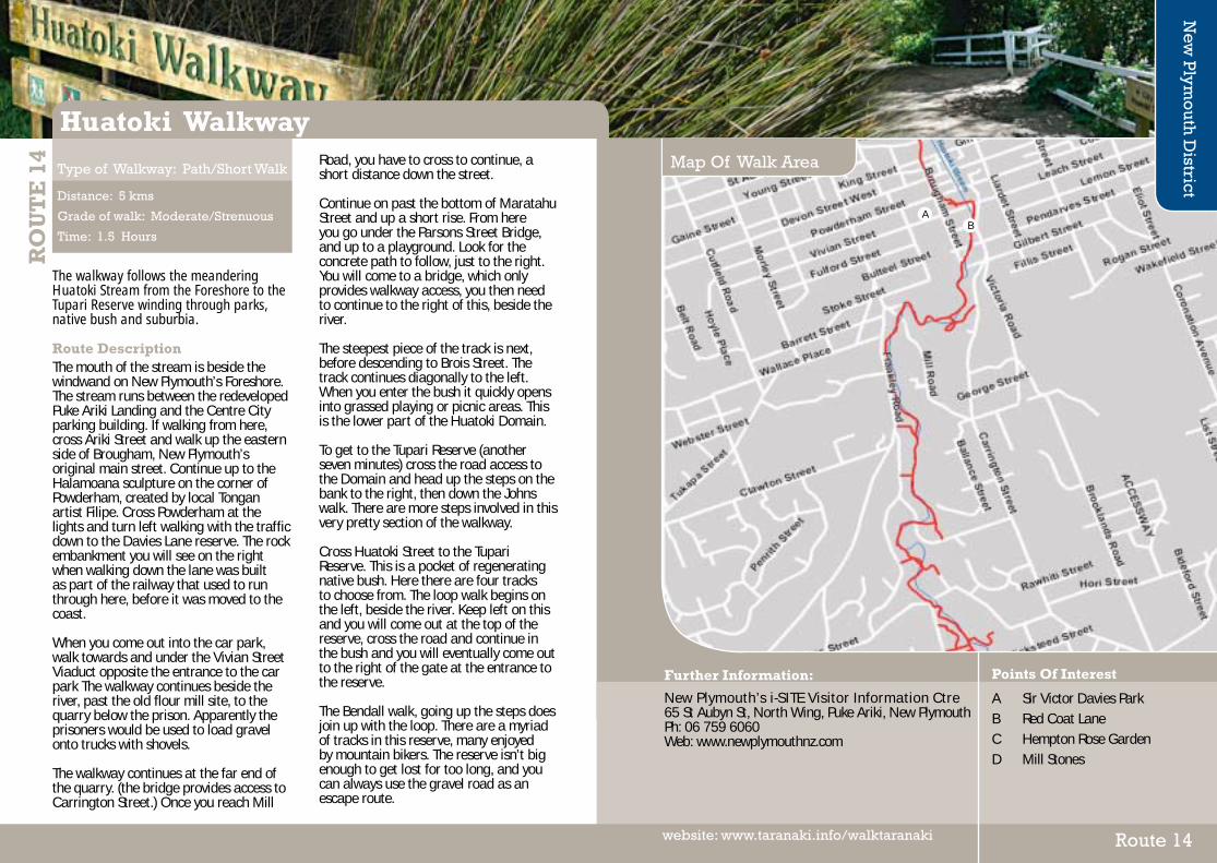
The walkway follows the meandering Huatoki Stream from the Foreshore to the Tupari Reserve winding through parks, native bush and suburbia. Route DescriptionThe mouth of the stream is beside the windwand on New Plymouth’s Foreshore. The stream runs between the redeveloped Puke Ariki Landing and the Centre City parking building. If walking from here, cross Ariki Street and walk up the eastern side of Brougham, New Plymouth’s original main street. Continue up to the Halamoana sculpture on the corner of Powderham, created by local Tongan artist Filipe. Cross Powderham at the lights and turn left walking with the traffic down to the Davies Lane reserve. The rock embankment you will see on the right when walking down the lane was built as part of the railway that used to run through here, before it was moved to the coast. When you come out into the car park, walk towards and under the Vivian Street Viaduct opposite the entrance to the car park The walkway continues beside the river, past the old flour mill site, to the quarry below the prison. Apparently the prisoners would be used to load gravel onto trucks with shovels.
The walkway continues at the far end of the quarry. (the bridge provides access to Carrington Street.) Once you reach Mill
Road, you have to cross to continue, a short distance down the street. Continue on past the bottom of Maratahu Street and up a short rise. From here you go under the Parsons Street Bridge, and up to a playground. Look for the concrete path to follow, just to the right. You will come to a bridge, which only provides walkway access, you then need to continue to the right of this, beside the river. The steepest piece of the track is next, before descending to Brois Street. The track continues diagonally to the left. When you enter the bush it quickly opens into grassed playing or picnic areas. This is the lower part of the Huatoki Domain. To get to the Tupari Reserve (another seven minutes) cross the road access to the Domain and head up the steps on the bank to the right, then down the Johns walk. There are more steps involved in this very pretty section of the walkway. Cross Huatoki Street to the Tupari Reserve. This is a pocket of regenerating native bush. Here there are four tracks to choose from. The loop walk begins on the left, beside the river. Keep left on this and you will come out at the top of the reserve, cross the road and continue in the bush and you will eventually come out to the right of the gate at the entrance to the reserve. The Bendall walk, going up the steps does join up with the loop. There are a myriad of tracks in this reserve, many enjoyed by mountain bikers. The reserve isn’t big enough to get lost for too long, and you can always use the gravel road as an escape route.
RO
UT
E 1
4
Distance: 5 kms
Grade of walk: Moderate/Strenuous
Time: 1.5 Hours
Type of Walkway: Path/Short Walk
Huatoki Walkway
Further Information:
New Plymouth’s i-SITE Visitor Information Ctre65 St Aubyn St, North Wing, Puke Ariki, New Plymouth Ph: 06 759 6060 Web: www.newplymouthnz.com
Map Of Walk Area
New
Plym
outh
District
Route 14website: www.taranaki.info/walktaranaki
Points Of Interest
A Sir Victor Davies ParkB Red Coat LaneC Hempton Rose GardenD Mill Stones
BA
P
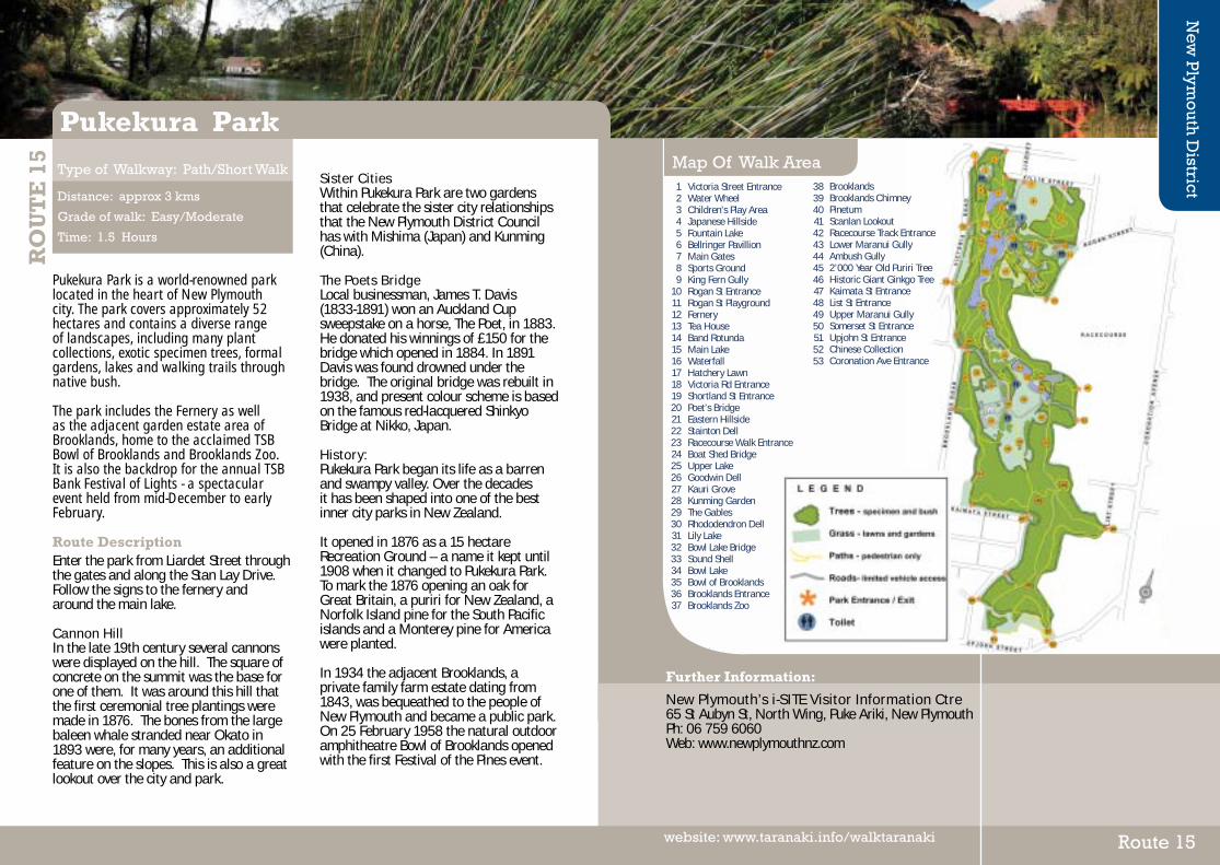
Pukekura Park is a world-renowned park located in the heart of New Plymouth city. The park covers approximately 52 hectares and contains a diverse range of landscapes, including many plant collections, exotic specimen trees, formal gardens, lakes and walking trails through native bush. The park includes the Fernery as well as the adjacent garden estate area of Brooklands, home to the acclaimed TSB Bowl of Brooklands and Brooklands Zoo. It is also the backdrop for the annual TSB Bank Festival of Lights - a spectacular event held from mid-December to early February. Route DescriptionEnter the park from Liardet Street through the gates and along the Stan Lay Drive. Follow the signs to the fernery and around the main lake. Cannon HillIn the late 19th century several cannons were displayed on the hill. The square of concrete on the summit was the base for one of them. It was around this hill that the first ceremonial tree plantings were made in 1876. The bones from the large baleen whale stranded near Okato in 1893 were, for many years, an additional feature on the slopes. This is also a great lookout over the city and park.
Sister CitiesWithin Pukekura Park are two gardens that celebrate the sister city relationships that the New Plymouth District Council has with Mishima (Japan) and Kunming (China). The Poets BridgeLocal businessman, James T. Davis (1833-1891) won an Auckland Cup sweepstake on a horse, The Poet, in 1883. He donated his winnings of £150 for the bridge which opened in 1884. In 1891 Davis was found drowned under the bridge. The original bridge was rebuilt in 1938, and present colour scheme is based on the famous red-lacquered Shinkyo Bridge at Nikko, Japan.
History:Pukekura Park began its life as a barren and swampy valley. Over the decades it has been shaped into one of the best inner city parks in New Zealand. It opened in 1876 as a 15 hectare Recreation Ground – a name it kept until 1908 when it changed to Pukekura Park. To mark the 1876 opening an oak for Great Britain, a puriri for New Zealand, a Norfolk Island pine for the South Pacific islands and a Monterey pine for America were planted. In 1934 the adjacent Brooklands, a private family farm estate dating from 1843, was bequeathed to the people of New Plymouth and became a public park. On 25 February 1958 the natural outdoor amphitheatre Bowl of Brooklands opened with the first Festival of the Pines event.
RO
UT
E 1
5
Distance: approx 3 kms
Grade of walk: Easy/Moderate
Time: 1.5 Hours
Type of Walkway: Path/Short Walk
Pukekura Park
Further Information:
New Plymouth’s i-SITE Visitor Information Ctre65 St Aubyn St, North Wing, Puke Ariki, New Plymouth Ph: 06 759 6060 Web: www.newplymouthnz.com
Map Of Walk Area
New
Plym
outh
District
Route 15website: www.taranaki.info/walktaranaki
Victoria Street EntranceWater WheelChildren’s Play AreaJapanese HillsideFountain LakeBellringer PavillionMain GatesSports GroundKing Fern GullyRogan St EntranceRogan St PlaygroundFerneryTea HouseBand RotundaMain LakeWaterfallHatchery LawnVictoria Rd EntranceShortland St EntrancePoet’s BridgeEastern HillsideStainton DellRacecourse Walk EntranceBoat Shed BridgeUpper LakeGoodwin DellKauri GroveKunming GardenThe GablesRhododendron DellLily LakeBowl Lake BridgeSound ShellBowl LakeBowl of BrooklandsBrooklands EntranceBrooklands Zoo
123456789
10111213141516171819202122232425262728293031323334353637
BrooklandsBrooklands ChimneyPinetumScanlan LookoutRacecourse Track EntranceLower Maranui GullyAmbush Gully2’000 Year Old Puriri TreeHistoric Giant Ginkgo TreeKaimata St EntranceList St EntranceUpper Maranui GullySomerset St EntranceUpjohn St EntranceChinese CollectionCoronation Ave Entrance
38394041424344454647484950515253

T
This is a circular walk in a 36 hectare blend of open spaces, plantations, bush and a wetland area (Barrett Lagoon). The domain is also a wildlife refuge. Explore an abundance of native bird life, wetland and lake habitats and indigenous vegetation in this urban oasis on the outskirts of suburbia. Route DescriptionThere are three different tracks you can take in Barrett Domain. Cowling Plantation Walk (10mins) As you enter the domain from Roto St, walk about 200m down a gravel track, on your right you will find the start of this walk. You will notice a cemented stone seat. On 17 February 1966 this seat was unveiled as a memorial to Mr Fred Cowling. These majestic kauri trees he planted are now more than 50 years old and provide a tranquil area in which to walk. This track continues on to Alba St and exits the domain, or you can turn and go over the bridge and walk through the trees until you come to a grassed area. At this point you can continue on to the Rayward Bush Walk or return to the main track. Rayward Bush Walk (20 mins)This short bush walk begins by entering through the main entrance off Roto St. Walk down the gravel track past the
Cowling Plantation sign until you come to the Rayward Bush Walk sign on your right. Walk over a grassed area, keeping a small pond on your left. Follow a grassed track up a small hill and enter the bush near the top of the sign. This area has regenerating forest plants which include tawa and kohe kohe. On exiting the bush you will find yourself in an open grassed area. From here you can continue on to your right towards the lagoon or return to the main entrance. To get to the main track walk across the paddock towards the entrance to the lagoon and then follow a track around to the left towards a gate. Lagoon Bush Walk (30 mins) This walk can be entered via the Davies Rd entrance or from the main entrance off Roto St. From Roto St, continue down the gravel track until you come to an open grassed area. To your left is the beginning of the Lagoon Bush Walk. This walk follows the Mangaotuku Stream, which runs through the domain. After reaching the bridge follow the lower track that runs alongside the Mangaotuku Stream. About 500m along you will come to a T junction. At the T junction you can either go down to a small gully the Mangaotuku Steam has carved out (note this is a dead end track), or continue up the hill to your right towards the lagoon. At the top of the hill are three tracks. The track on your right will take you to the Rayward Bush Walk. The other two tracks will take you to Barrett Lagoon.
RO
UT
E 1
6
Distance: 3 kms
Grade of walk: Moderate/Strenuous
Time: 1 - 1.5 Hours
Type of Walkway: Path/Short Walk
Barrett Domain
Further Information:
New Plymouth’s i-SITE Visitor Information Ctre65 St Aubyn St, North Wing, Puke Ariki, New Plymouth Ph: 06 759 6060 Web: www.newplymouthnz.com
Map Of Walk Area
New
Plym
outh
District
Route 16website: www.taranaki.info/walktaranaki
Points Of Interest
A Picnic Area B Lagoon Bush Walk C Kororako Pa SiteD Rayward Bush Walk
B
C
A N
Barrett Lagoon
D

Here you will see an outstanding example of a lush, temperate rainforest with kohekohe, tawa, pukatea and nikau palms. There is an early exit option if you need it. The name Ratapihipihi is derived from a traditional Maori hunting method. Hunters would attract kaka and other birds by sitting in a tree and making a “pihipihi” call by blowing through a leaf placed in the mouth. The birds attracted were then killed with a short club and eaten.
Route DescriptionTo the left of the lawn is a small wooden gate that leads you into the forest and here you’ll see the glossy leaves of the kohekohe which bring a tropical look to the forest. This track is well graded though steep in places. Follow it to the valley floor where you will cross the stream and its tributaries a few times while always being graced with stunning images of coastal forest. A small scenic waterfall presents a lovely photo opportunity only a few metres beyond the first track exit back to your start point. A steady stream of timber was taken from this area, first to build a schooner to take goods to Sydney and later to build bridges. A sharp eye may spot some of
the old sawpit holes either side of the track.
As you make your way downstream Pukatea and Nikau palms fill this damper environment. Look for the unusual shapes that some of the trees have grown into. The tawa in particular have elbows multi trunks and even a window. They’re the dominant canopy trees. As you come around the edge of the forest at the track’s end you can see a wall of foliage that comes out to meet the light. In here you will see trees that were planted in earlier years, to represent trees from outside the region. These include kauri, beech and tanekaha. With it’s nikau palms and dappled light, it’s like a walk in the tropics. It’s well worth a look.
RO
UT
E 1
7
Distance: 1.9 kms
Grade of walk: Easy
Time: up to 1 Hour
Type of Walkway: Path/Short Walk
Ratapihipihi Scenic Reserve Track Map Of Walk Area
New
Plym
outh
District
Route 17website: www.taranaki.info/walktaranaki
Further Information:
Dawson Falls Visitor CentreManaia Rd, KapongaPhone: 06 756 0990Website: www.doc.govt.nz
Egmont National Park Visitor Centre2879 Egmont RdPhone: 06 756 0990
Points Of Interest
A Picnic AreaB Waterfall
B
A

Lake Mangamahoe is a 262 hectare production forest, popular place for mountain biking, walking, running and bridle path for horses, combined with a scenic lake and park. It also has spectacular views of Mount Taranaki. In the early 1920’s the Council purchased land for the construction of a dam and a lake to act as a water catchments area for the expanding city of New Plymouth. In 1932 the lake was created by forming a dam across the valley and submerging 79 acres. It was named after the Mangamahoe stream which flows into the upper reaches of the lake. Water from both the stream the nearby Waiwakaiho River feeds the lake through a 548m pipe. In order to protect the step hillside from eroding, development planting was undertaken and shelterbelts were planted to protect the pine trees growing in what is now the Mangamahoe forest. The lake itself is also significant to the district in terms of power generation. Trustpower Ltd administers this from the Mangorei Power Station. Route DescriptionThe walk takes you on a journey around the Lake through production forest, up to impressive lookouts and among mature ornamental tree plantings that are mixed with pockets of regenerated native bush. The circuit walk is an enjoyable walk for people of all ages. However, there are
some steep undulating sections on the walk that require a reasonable standard of fitness. The walk may be started at either end of Lake Road. Along the circuit walk you will meander through a small collection of Redwood trees which were planted in 1931. In California, where they originate, they are known as “Giants of the Forest”, reaching heights of up to 111 metres. Redwoods are known for their longevity. The growth rings of fallen trees indicate that some have lived for more than 2,000 years. On the eastern side of the lake the circuit walk gives the choice of two routes: 1) The upper ridge of this walk, takes you over a forest access road used for logging operations. As this road is up high on a ridge above the lake it provides remarkable views of surrounding farmland, Mt Taranaki/Egmont and the lake itself.2) The lower lakeside route takes you on an ambling walk close to the lake edge. Lakeside vegetation and regenerating pockets of native bush provide a cooling atmosphere and a home to many birds.
RO
UT
E 1
8
Distance: 3 or 6 kms
Grade of walk: Strenuous
Time: 2 or 1.5 Hours
Type of Walkway: Path/Short Walk
Lake Mangamahoe
Further Information:
New Plymouth’s i-SITE Visitor Information Ctre65 St Aubyn St, North Wing, Puke Ariki, New Plymouth Ph: 06 759 6060 Web: www.newplymouthnz.com
Map Of Walk Area
New
Plym
outh
District
Route 18website: www.taranaki.info/walktaranaki
Points Of Interest
A Redwood plantation B Lake Dam C Bridle Path D Forestry production
N
B
C
A
D

Picnic beside the Waiwhakaiho River and choose from two easy short walks suitable for all the family. Both walks can be accessed from the Meeting of the Waters carpark. This quiet Meeting of the Waters scenic reserve is just 3km south of New Plymouth and from here you access the Araheke track. The track itself is wheel and pushchair friendly but the wheelchair access to the start of the track is yet to be completed. Wheelchair users can access the swingbridge near the start of Araheke by picking up the key for the gate from DOC’s Taranaki Area Office. Route DescriptionWalkers parking at the Meeting of the Waters have a 20 minute stroll through tawa, kahikatea, matai and large totara trees to the swingbridge. You’ll begin with steps down along a path that borders a popular swimming hole. Veer right around a concrete path and onto a track leading to a wooden bridge where the tailrace waters of the Mangorei Hydro Station rush underneath.
Walk over the bridge and follow the fence line and beaten track past a stand of totara trees. Continue on, with the river to your left. A dip and climb and some small round rocks make this section a little bumpy. On your right is TOPEC an Outdoor Pursuits Centre, well utilised by
the schools of Taranaki. Walk on to the swingbridge where a small springed gate opens on to the bridge. Turn right at the end of this bridge for a 30 minute stroll around a loop on a flat and friendly track and boardwalks. While strolling under a canopy of a podocarp forest, admire the lush green tree ferns and coprosma carpeted at their feet by mosses, grasses and exotic foliage. Native trees like tawa, matai and totara and smaller ferns also present a spectacular sight as the sunlight filters through. The Araheke Stream is quite close at some points and it’s crystal clear unless in flood. Continue around the loop and back to the swingbridge.
RO
UT
E 1
9
Distance: 3 kms return
Grade of walk: Easy
Time: 2 Hours
Type of Walkway: Walking Track
Meeting of the Waters/ Araheke Bush Walk
Further Information:
New Plymouth’s i-SITE Visitor Information Ctre65 St Aubyn St, North Wing, Puke Ariki, New Plymouth Ph: 06 759 6060 Web: www.newplymouthnz.com
Map Of Walk Area
New
Plym
outh
District
Route 19website: www.taranaki.info/walktaranaki
Points Of Interest
A Meeting of the Waters B Trust Power Generation Taranaki C TOPEC Camp D Gate for wheelchair access
B
C
A
N
To New Plymouth
To Inglewood
D

The Stratford Heritage Walk combines the unique features of Stratford: areas of parks and gardens; the crystal clear mountain fed waters of the Patea River; the Shakespearean background reflected in street names; and the pioneering development of the town as outlined by many buildings and points of special interest. Points of InterestA - Bell Tower This tower was constructed in 1981. The bells were removed from the old clock tower (built in 1924 and demolished in 1963) and lay in disuse for 20 years until this tower was built. The original clock tower and bells were built as a memorial to the soldiers of Stratford who fell in the Boer War and WW 1. B - Malone Memorial Gates Largest war memorial to an individual soldier in NZ erected in 1923 to recognise the outstanding bravery and leadership of Lieutenant-Colonel W G Malone of Stratford who died at the battle of Chunuk Bair at Gallipoli. C - Kauri Tree and Lone Pine This Kauri Tree was planted in 1954 to commemorate the visit of Queen Elizabeth II and Prince Phillip to Stratford. The lone conifer tree was planted from a seedling off Lone Pine Ridge in Gallipoli. D - Swingbridge Erected in 1902 to commemorate the coronation of King Edward VII.
E - Otago Chambers Built in 1912-13 this impressive brick structure has housed a law firm associated with the Thomson family since that date. F - Newton King Once a livery stable then vehicle and machinery centre – firstly horse drawn and then petrol driven means of conveyance. I - Victoria Bridge This wide bridge was opened in 1924 by the Prime Minister, Hon J G Coates.J - Salvation Army Building This has been the site of the Salvation Army since it was built in 1894. L - Curtis Store Site Site of the first shop in Stratford in 1878. M - Hall of Remembrance This unique war memorial of photographs commemorates soldiers from the district who lost their lives in the Boer War and two World Wars. O - Post Office Site of the original Post Office built 1896.P - Clock Tower This ‘Elizabethan’ clock tower was built in 1996 and surrounds the previous tower built in the 1960’s. The tower hosts NZ’s first glockenspiel which performs four times daily (10am, 1pm, 3pm & 7pm) a five minute sequence depicting the world’s best known love story “Romeo and Juliet”. Q - Kings Theatre Built in 1918, the first talking pictures Southern Hemisphere where shown here in 1925. R - Prospero Place: Originally part of a gully and stream which was piped and fully filled in. Now a popular pedestrian link through to Miranda Street.
RO
UT
E 2
0
Distance: 1 km
Grade of walk: Easy
Time: 30 - 40 mins
Type of Walkway: Path/Short Walk
Stratford Heritage Walkway
Further Information:
Stratford’s i-SITE Visitors CentreProspero Place, Broadway, Stratford Ph: 06 765 6708 or: 0800 765 670Web: www.stratfordnz.co.nz
Map Of Walk Area
Stratford
Route 20website: www.taranaki.info/walktaranaki
BroadwayPortia St
Fenton St
Q
R
A
B
CD
E
F I
J
L
M
P
O
Prospero Place
Service Lane
Patea River
Service Lane

The Carrington Walkway is a loop town bush walk encompassing past planting of native bush into which European and American species have been introduced. Along the walkway discover some impressive views of Mt Taranaki/Egmont which rises 2,518 metres (8,260 feet) and which dominates our western horizon. Route DescriptionStart at the Malone Gates located on the corner of Fenton and Portia Streets where you will find a set of white marble gates erected in 1923 as a tribute to Lieutenant Colonel William George Malone who was killed after successfully leading the Wellington Battalion in an attack on the Turks at Chunuk Bair on 8 August 1915. Follow the signage from here. This mid section provides a choice of routes, which adds interest for those doing the round trip or subsequent walks. Stratford’s climate and soil provides ideal conditions for growing. Visit the McCullough Rhododendron Dell in spring. Formed in the 1960’s these gardens contain several hundred rhododendrons and include some propagated from seed sent from the Royal Botanical Gardens in Edinburgh, Scotland as well as some from Lord Rothchild’s gardens in England. In 1952 the Clemow Reserve, a native arboretum, was established along the northern edge of the Rhododendron Dell.
As the river winds its way down through the township there are four pedestrian bridges that cross the river giving panoramic views of the steep banks and vegetation. Wait long enough on these bridges and you may glimpse a brown trout. Also there are sizeable natural pools (used by past generations as swimming holes) which may contain the occasional trout. A boulder weir was also constructed to dam the flow of the river and two caves were dug into the banks for changing sheds and are still visible today.
View the stock ford which crosses the river and which was used to get cattle to the saleyards on Miranda Street from the south and west. Cattle or horses were accorded the right of way on the streets! In 1952 these saleyards were closed and new yards opened in Esk Road. Cross the State Highway (Broadway) and walk under a rail bridge and you will find Windsor Park, a delightful miniature landscaped area which includes several large magnolias and many fine specimens of rhododendrons.
To the east of Windsor Park, is the Thomson Arboretum established in 2001 with the plantings reflecting a “Taranaki feel”. The planting on the eastern side of the arboretum is designed to recreate a sense of the bush edge while the western side contains plants reminiscent of ancient primeval forests. Some sections of the walkway follow farmland boundaries, giving views across the country side of rolling green pastures and grazing cattle. Wooden stiles are used to cross all stock fences which help make access reasonably easy.
RO
UT
E 2
1
Distance: 3 - 9 kms
Grade of walk: Easy/Moderate
Time: 1 - 4.5 Hours
Type of Walkway: Walking Track
Carrington Walkway
Further Information:
Stratford’s i-SITE Visitors CentreProspero Place, Broadway, Stratford Ph: 06 765 6708 or: 0800 765 670Web: www.stratfordnz.co.nz
Map Of Walk Area
Stratford
Route 21website: www.taranaki.info/walktaranaki
Points Of Interest
Red Carrington WalkGreen Three Bridges Trail Orange Clemow WalkPurple Western LoopYellow Eastern Loop
Broadway
Cordelia St
Swansea Rd
Page StBrecon Rd
Portia St
Celia St
Regan St
Fenton St

The Cardiff walkway is sited on the Waingongoro River at Cardiff approximately 6 kilometres from Stratford. It is a pleasant walkway through farmland and natural bush which gives access to points of local historical significance. This Walkway is ideally suited for combining with a day’s outing to Dawson Falls in Egmont National Park and/or Hollard Gardens near Kaponga. This walkway was developed by members of the Cardiff Branch of Federated Farmers to coincide with the centennial of the Cardiff School and District in May 1986. Route DescriptionThe walkway is an attractive and tranquil riverbank walk. Changes of direction and elevation provide variety as there are steep slopes and river flats. It provides a well-maintained path through bush and farmland with some steep gradients and follows the natural contour with tracks constructed as far as possible with minimum disturbance to the land form. From the carpark on Opunake Road the walkway follows the river on both banks upstream from the Opunake Road bridge for approximately 1.5 kilometres (giving a total length of 3 kilometres). The walkway is a pleasant walk through farm land and natural bush and gives access to points of historical significance otherwise little known beyond the immediate locality.
Adequate supplies of water for the nearby Cardiff Co-Operative Dairy Factory Company Limited caused anxiety as soon as the supply from the well, sunk when the factory was built in 1891, proved insufficient. Ultimately supplies were established by a well, by water from the Waingongoro River and by a bore thus making the historical significance of the area as being one of the first dairy factory water supplies in New Zealand. The factory closed in 1951. Visit the sites where two weirs were built to dam the river to operate a double ram system which pumped water to the Cardiff Dairy Factory and a recently constructed swing bridge. Provision has been made for a short sidetrack, which ends at a cliff-top lookout platform above the river giving views of the mountain, surrounding farm lands and a 55 metre Natural Gas Pipeline bridge. If your time is limited, or if you just want to sit back and enjoy nature then follow some steps and after a short 2 to 3 minute stroll through a natural bush pathway you will discover a picnic area. From this area you catch a glimpse of the river and its stoney banks. Seats and a table are provided but why not enjoy your picnic on the river bank and enjoy the sound of the water and the native bird song.
RO
UT
E 2
2
Distance: 3 kms
Grade of walk: Moderate/Strenuous
Time: 1.5 Hours
Type of Walkway: Walking Track
Cardiff Walkway
Further Information:
Stratford’s i-SITE Visitors CentreProspero Place, Broadway, Stratford Ph: 06 765 6708 or: 0800 765 670Web: www.stratfordnz.co.nz
Map Of Walk Area
Stratford
Route 22website: www.taranaki.info/walktaranaki
Points Of Interest
A Layers of volcanic eruptions B Outlook over old Dairy FactoryC Swing Bridge D Two weirs E Old sand trap & Water Ram
B
C
A
N
To Opunake Cardiff Monument
Cardiff Rd
Opunake Rd
D
E

Hollard Gardens is an interesting and relaxing place to visit at any time of the year. Primarily a plant collection, the style of the Gardens is informal and much of the 4 hectare garden is woodland. The Gardens are renowned for their repository of plants, representing exotic introduc-tions and New Zealand bred plants span-ning the last 75 years. The Gardens are their best during October and November.
Hollard Gardens was the creation of Bernie and Rose Hollard. Bernie (1903 – 1996), from a local dairy farming family, began the garden in 1927. He was an avid plant collector throughout his life and had a reputation as one of NZ’s foremost plantsman. Rhododendrons, camellias and azaleas were his favourite plants.
Route DescriptionThis is an easy walk through extensive gardens and bush. At the Gatehouse informative wayfinding information and visitor guides are available to assist you in your walk.
There are two marked trails which you can follow at Hollard Gardens:
Bernie’s WalkBernie’s Walk takes you right around Hollard Gardens and includes the Swamp which is a spectacular display of bog plants in the Spring.
Rose’s WalkRose’s Walk is a short stroll that explores the maturing New Garden and the intimacy of the Old Garden.
During either walk you will experience many interesting and beautiful plants. You will also learn about the history of the Gardens and the early days of farming.
These walks are interesting at any time of the year and there are a number of shelter and lookout points throughout the property. There is also a children’s playground to enjoy.
Visitors are encouraged to explore and experience other paths and walkways that interlink the two marked trails.
Hollard Gardens are owned and managed by the Taranaki Regional Council.
RO
UT
E 2
3
Distance: 2 kms
Grade of walk: Easy
Time: up to 2 Hours
Type of Walkway: Walking Track
Hollard Gardens
Further Information:
Stratford’s i-SITE Visitors CentreProspero Place, Broadway, Stratford Ph: 06 765 6708 or: 0800 765 670Web: www.stratfordnz.co.nz
Map Of Walk Area
Stratford
Route 23website: www.taranaki.info/walktaranaki

The Opunake Walkway is the longest of the formal South Taranaki walks and takes you through beautiful lake and beach scenery. It takes you around Opunake Lake and across the cliffs, providing views of Te Namu Pa, Mt Taranaki and the rugged coastline. The lake is popular for boating, swimming and water skiing. Points of InterestThe walk can be started from a number of easily accessible points but if you wish to complete the whole walk the best place to begin is by the boat ramp at the Opunake Lake (Layard Street). Along this walk you will find many points of great historic and environmental interest, including: Opunake Lake The lake is used to provide hydroelectricity. It was once a vegetable garden used to supply the Armed Constabulary and early settlers. There are public toilets at this stop for your use.Armed Constabulary Cemetery The cemetery is located on the headland that juts into the lake. It has four historic headstones. The perimeters of the cemetery are unknown but some cairns help estimate the cemetery boundaries.Orimupiko Cemetery This cemetery is adjacent to the entrance to the Armed Constabulary Cemetery. It is located on a former Pa site. Waiaua River MouthThis is a must-stop location – it will offer
you extraordinary views of Taranaki’s dynamic coastline. The Cottage Hospital The hospital has an amazing history for New Zealanders as it was the birthplace of many famous people (including Peter Snell). Opunake Beach The Riviera of South Taranaki is an outstanding, natural surf attraction that draws visitors and surfers from all over the world. A holiday park and playground are available. The beach was also recently upgraded to offer barbeques and picnic sites for everyone’s use. The Lion’s Lookout The lookout is located next to the ramp by the old wharf and offers clear views of the Taranaki Bight.Middleton Bay Middleton Bay has a boat ramp for easy launching (this is not a safe for swimming). Te Namu Pa The Pa is visable from the northern end of the walkway and is an extremely important site in Taranaki. It was the location of a famous battle where Wiremu Kingi Matakatea repelled 800 Waikato Maori and successfully withstood a month-long siege armed with a single rifle. The best access to the site is via Opunake Cemetery and then over the Otahi Stream. The Te Namu Pa is on private property and the owners and the Historic Places Trust ask that the area be treated with care and respect. There are open food storage pits and tunnels on the site and these can be dangerous. There are comprehensive maps for your information at either end of the walk.
RO
UT
E 2
4
Distance: 7 kms
Grade of walk: Easy/Moderate
Time: 3 - 4 Hours
Type of Walkway: Walking Track
Opunake Walkway
Further Information:
South Taranaki i-SITE Visitor Centre55 High Street, Hawera Ph: 06 278 8599or: 0800 111 323Website: www.stdc.co.nz
Opunake LibraryPlusTasman St, Opunake
Map Of Walk Area
South
Taranak
i
Route 24website: www.taranaki.info/walktaranaki
Points Of Interest
A Opunake Lake Boat Ramp B Armed Constabulary Cemetery C Opunake BeachD The Lions Lookout E Middleton Bay F Opunake Cemetery
N
Beach Rd
Tasman St
Hector Pl
Allis
on S
t
B
CD
E
A
F
Halse Pl
Wils
on R
d
South Rd

The walk can begin from either Ohawe Beach or Waihi Beach. Ohawe Beach is accessed by turning left into Ohawe Road from Surf Highway 45 five km west of Hawera. Alternatively you can turn west into Denby Road at Hawera. The descent to Waihi Beach is via a steep gravel track from the carpark at the end of Denby Road.
Safety First This is a tidal route and is safe to walk up to 2.5 hours before and after Low tide. Don’t forget to check the tide tables before you leave. Swimming is not safe along the walk but there is a safe swimming area at the end of the Boat Ramp at Ohawe Beach. Toilets and changing rooms are available here.
Points of Interest
A. Waingongoro River and Ohawe BeachIt was here at the mouth of the Waingongoro River that the first Maori settlers in Taranaki lived in small undefended settlements. The remains of Moa have been found in cooking ovens around the edge of the present camping ground. Later, in the 1940’s a strongly fortified Pa stood on an isolated hill within the last seaward bend of the river, where the car park is now located. The hill and pa have since been entirely removed by quarrying.
B. CliffsThe uplifted marine terraces that form the South Taranaki coastline from Ohawe to Wanganui begin here. These cliffs are characterised by spectacularly high soft papa rock that forms the lower part of the cliffs. These have been uplifted from the sea over the past 3 million years.C. Rock PoolsThe coastline features coastal reefs with two particularly large and accessible areas of rock pools. These pools contain a wide range of interesting sea life and are safe to explore at low tide.D. Tram RailsRemnants of a tram rail can be seen at the base of the cliffs near the end of Hauroto Road. This rail was used to haul shingle and sand from the beach to build roads and some of the earlier concrete buildings in South Taranaki.
RO
UT
E 2
5
Distance: 5 kms
Grade of walk: Moderate
Time: 2.5 - 3 Hours return.
Type of Walkway: Walking Track
Ohawe Beach to Waihi Beach Coastal Walk
Further Information:
South Taranaki i-SITE Visitor Centre55 High Street, Hawera Ph: 06 278 8599or: 0800 111 323Website: www.stdc.co.nz
Map Of Walk Area
South
Taranak
i
Route 25website: www.taranaki.info/walktaranaki
Points Of Interest
A Waingongoro River Mouth & Ohawe Beach B CliffsC Rock Pools D Tram RailE Rock Pools
B
C
N
To Hawera
D
E
To Manaia
South Rd
Ohawe Rd
Hau
roto
RdA
Waingongoro River

Rotokare, the ‘rippling lake’ is part of a peaceful and undisturbed bush reserve. It has a surface area of 17.8 hectares and an average depth of over 6 metres. It is fed entirely by natural springs, with the only outlet being the Te Ararata Stream at the western end of the lake. The lake, together with the surrounding 212 hectares of thriving native bush, forms the Rotokare Scenic Reserve which is administered by the South Taranaki District Council.
In 2008 the Rotokare Scenic Reserve Trust completed construction of a predator proof fence around the reserve. This has created a pest free sanctuary which provides diverse habitats ranging from the lake itself to the wetlands, swamp forest and bush.
Boating, water-skiing and kayaking are popular pursuits on the lake, although power craft are excluded from the lake from May to November to provide a peaceful refuge for birdlife. Dogs are prohibited in the reserve at all times.
HistoryMaori have utilised the lake and surrounding areas as a food source for many years and some of the flora is still used today by local Maori for medicinal purposes. An archaeological site, a midden, which holds the remains of many fresh water mussels, is located in this area.
Route DescriptionThe walkway starts at the carpark/picnic area and encircles the lake. It follows the southern shore of the lake before entering native bush for most of the remainder of the walk. The track is well graded and a boardwalk extends through the swamp forest. Sturdy walking shoes are recommended, particularly in wet weather as there are some muddy areas.
Allow approximately an hour and a half to two hours to enjoy the walk and the views around the lake or a bit more if you want to take in the fabulous birdlife. Seats have been installed in some of the best viewing places to enjoy the birdlife along the route. The walk emerges on Sangster Road a few hundred metres from the starting point.
There are a wide variety of bird species living around the lake and this is an important stopover for many different migrating birds. Bellbirds, Tui, Keruru, Grey Warbler, Fernbird and Spotless Crake frequent the forest. Water birds abound on the lake margins and often in the thickets about the tracks. One of the larger inlet streams offers a rare opportunity to view Banded Kokopu (adult whitebait) and Tuna (eel) in their natural habitat.
RO
UT
E 2
6
Distance: 4.2 kms
Grade of walk: Easy
Time: 1.5 - 2 Hours
Type of Walkway: Walking Track
Lake Rotokare Walk
Further Information:
South Taranaki i-SITE Visitor Centre55 High Street, Hawera Ph: 06 278 8599or: 0800 111 323Website: www.stdc.co.nz
South
Taranak
i
Route 26website: www.taranaki.info/walktaranaki
Points Of Interest
A Viewing seat for Fernbird and Spotless Crake B Viewing seat for waterfowl C Giant Pukatea tree D Bridge where Banded Kokopu can be seen
Map Of Walk Area
N
How to Get there:
B
A
D
C

This is an attractive short lakeside walk located at the southern end of Lake Rotorangi. The walkway takes you across the spillway and dam and through virgin bush filled with Tawa and Hinau. A feature of the walkway is a grove of black beech or Tawhairauriki, which flower in a burst of brilliant red in October and November.
The walk is accessed from State Highway 3 just north of Patea via Ball Road and Rotorangi Road. The camp ground located by the dam offers toilet facilities, showers and tent sites.
HistoryLake Rotorangi is the longest man-made lake in New Zealand at 46 kms and was created by the damming of the Patea River. The dam is constructed from 1.2 million cubic metres of sandstone and siltstone that abound in the area and was the first large dam to be constructed using these materials. The dam is 82 metres high, which made it the fourth highest dam in New Zealand at the time of its construction, and 160 metres across.
There are three carvings located at the dam site, all crafted from Totara in the traditional Taranaki style by Patea carvers under the tutelage of Reverend Te Napi Waaka. They are Pou Tiaki, Rahui and a carved archway consisting of two amo (uprights) and two maihi (apex boards).
Route DescriptionThe Lake Rotorangi Hydro Walk crosses the dam from the car park and enters a mixed Podocarp and Manuka forest. Travelling in an anticlockwise direction the track sits above the shore line and leads around a peninsula. Stay alert to the chance of spotting Parakeet birds in the forest.
On the northern side of the peninsula the track offers stunning views of the lake as it gradually climbs to a high point, before descending back to the dam.
There are a number of seats on which to rest and enjoy the birds and bush as well as views of the lake and downstream river.
RO
UT
E 2
7
Distance: 1.5 kms
Grade of walk: Easy
Time: 40 mins
Type of Walkway: Walking Track
Lake Rotorangi Walk
Further Information:
South Taranaki i-SITE Visitor Centre55 High Street, Hawera Ph: 06 278 8599or: 0800 111 323Website: www.stdc.co.nz
Map Of Walk Area
South
Taranak
i
Route 27website: www.taranaki.info/walktaranaki
Points Of Interest
A Patea DamB Campground C Boat rampD Lookout
B
NTo Ball Rd
A
Rotorangi Rd
D
C

The Patea River Historic Walkway leads from the Patea Beach and follows the river up to York Street with several interesting historical sites along the way. The walk can be started at either end and if you finish at the beach you can enjoy a meal using one of the free electronic barbeques in the picnic area. Toilets are available at the beach.
Route DescriptionLeaving from the boat ramp on Turi Street the walkway leads alongside the river through pastureland and pine forest. A series of seven illustrated signs outline significant historic points of interest dating back to the 1860s. Main features are stories from the Patea wharf and port, the meat industry, Wai o Turi Marae, Haere Hau Pa and Dawsons Redoubt.
The signs feature historical photographs and watercolours from the South Taranaki District Museum archives as well as illustrations from award winning New Zealand botanical artist Audrey Eagle.
If entering the walkway from the York Street entry there is a steep climb which can be muddy and slippery in wet weather.
RO
UT
E 2
8
Distance: 1.5 kms
Grade of walk: Easy/Moderate
Time: 1 Hour
Type of Walkway: Walking Track
Patea River Historic Walkway
Further Information:
South Taranaki i-SITE Visitor Centre55 High Street, Hawera Ph: 06 278 8599or: 0800 111 323Website: www.stdc.co.nz
Map Of Walk Area
South
Taranak
i
Route 28website: www.taranaki.info/walktaranaki
Points Of Interest
A Woolstore Wharf B Patea Port C The Meat Industry D Wai o Turi Marae E Dawson Redoubt F Haere Hau Pa
N
Taranaki Rd
Patea River
York St
C
A
E
Pilo
t Sta
tion
Rd
Victoria
St
Tren
t St
Egmont St
B
D
F

Re
gio
nal
Map
Walk TaranakiREGIONAL MAP R
eg
ion
al Map
Taranaki offers countless opportunities to experience the region’s unique natural environment, vivid historical sites and picture-perfect mountain.
The best way to make the most of these opportunities is to explore Taranaki on foot.
This guide to many of Taranaki’s best walks is the best place to start. Featuring route information, detailed maps, and points of interest along the way, this is a vital handbook for anyone keen to explore the best of Taranki - a region truly ‘like no other’.
www.taranaki.info/walk
This publication was produced by Venture Taranaki, with valuable advice and assistance from the Department of Conservation, New Plymouth District Council, Taranaki Regional Council, Stratford District Council and the South Taranaki District Council. This guide covers the main Taranaki walks, but there are countless other discoveries and adventures to be had in the region. For more information visit www.taranaki.info/walk. All efforts have been made to ensure information provided in this publication is accurate, but track conditions and situations do change and some tracks in this guide require a high level of skill and technical knowledge. If you are unsure then we advise you to seek expert guidance.
VentureTARANAKITe Puna Umanga
Images courtesey of:Rob Tucker
New Plymouth District CouncilSouth Taranaki District Council
Stratford District CouncilTaranaki Regional Council
Venture Taranaki Trust