a virtual globe tool for searching and visualizing geo ...canut/eprints/2013-mtap.pdf · a virtual...
TRANSCRIPT
A virtual globe tool for searching and visualizinggeo-referenced media resources in social networks
Arturo Beltran & Carlos Abargues & Carlos Granell &Manuela Núñez & Laura Díaz & Joaquín Huerta
# Springer Science+Business Media, LLC 2012
Abstract The current collaborative context and resource sharing that drives Web 2.0 isgaining importance within academia and industry, which is stimulating the development ofnew techniques for content retrieval, sharing and analysis over user-generated media con-tent. This poses new challenges and research opportunities in spatial-based discovery mediaresources over varied sources, since location context is being increasingly supported in mostof these social networks and services. In this paper, we present a virtual globe tool forsearching and visualizing geo-referenced media resources. Our approach is based on theintegration of search technologies, description languages for annotating collections of geo-referenced media resources and visualization techniques. The combination of these techni-ques is materialized in a virtual globe-based tool to facilitate searching and presentation ofgeo-referenced media resources available in different social networks.
Keywords User-generated content retrieval . Social networks . Geo-referenced mediaresources . Virtual globes . OpenSearch . KML .MIMEXT
1 Introduction
Users are dominating the Web 2.0 vision. They have rapidly become providers of content ina new age of social multimedia identified by the increasing flow of web-based sharing and
Multimed Tools ApplDOI 10.1007/s11042-012-1025-0
A. Beltran : C. Abargues : C. Granell (*) :M. Núñez : L. Díaz : J. HuertaInstitute of New Imaging Technologies, Universitat Jaume I, Castellón, Spaine-mail: [email protected]
A. Beltrane-mail: [email protected]
M. Núñeze-mail: [email protected]
L. Díaze-mail: [email protected]
J. Huertae-mail: [email protected]
community services [7]. As content is now mostly user-generated, location has become thepredominant context in annotating any type of resources, leading to huge amounts of geo-referenced information in practically any domain [16].
Therefore, the geo-location of any kind of resource is acquiring a fundamental role in awide range of applications. Examples of this trend are geo-tagged pictures: users areincreasingly annotating their photographs, either manually or automatically via GPS-awaredevices, to position them geographically in virtual globes or map visualization services.Nevertheless, geo-tagged images represent only one type of resource available in thecollaborative environment empowered by social networks and Web 2.0 services. Essentially,users are increasingly demanding the possibility of sharing other types of geo-referencedmedia resources, such as text files, videos, audio and tweets, through collaborative geo-spatial applications like virtual globes [7]. In this sense, virtual globes are becoming the“fusion platform” of choice that allows the combination of media content coming fromdisparate social networks, sources, and services to cover a wide range of user needs [4].
User-generated content is growing exponentially which allows people to share content ata great scale [6]. However, this also poses new research challenges in spatial-based discov-ery of on-line multimedia content [40]. Rather than using specific search interfaces for anysort of social network, users would desire a common search strategy that spans uniformlyover disparate social networks. Otherwise, users need to know each specific search API(Application Programming Interface) of the targeted social networks and services used. Thisimplies that client applications increase in complexity and become less scalable, sincesearching over a new social service requires the understanding of its search API. Toovercome this issue, we provide a uniform, homogeneous search interface to augment thevisibility of user-generated content over different social networks. The same search interfaceis used regardless of the nature of the social networks and services queried. Furthermore, thecontributions of this paper are three-fold:
& A simple but powerful enough tool to search media resources in social services andnetworks.
& A KML (Keyhole Markup Language) extension to annotate collections of geo-referenced media resources.
& A virtual globe application to enable the searching, visualization, and reproduction ofgeo-referenced media content.
In this paper we underline the role of virtual globes as data fusion tools for experts and thegeneral public alike. With this goal in mind, the first contribution is a uniform spatial-basedquery mechanism integrated in a virtual globe tool that allows us to search and collect mediaresources from diverse Web 2.0 sources. This provides users with a mechanism to easilysearch media data not only based on keywords or tags but also considering geospatialconstraints like a given geographical area. The result set in terms of collections of geo-referenced media resources is then codified in a proposed KML [45] extension focusedparticularly on geographic and media type annotations. MIMEXT (MIME extension) is thusthe second contribution, a KML extension that exploits the power of KML to contain anytype of geo-referenced media content. The third contribution is realized by the VisioMI-MEXT application which extends a virtual globe tool to comprise together the searching,visualization, and reproduction of these collections of geo-referenced media resources over avirtual globe.
VisioMIMEXT aims to improve searching and visualizing of user-centric media content,although our assumption here is that online media content is already somehow geo-tagged,
Multimed Tools Appl

either manually or by automatic processes. Recent and prominent research works aredevoted to alleviate the issue of geo-tagging media content manually [32, 37], yet fewworks are still centred on searching and retrieving such geo-tagged media content.
The rest of the paper is organized as follows. We overview related work in the areas ofgeospatial-based retrieval of multimedia, annotation, and virtual globes in Section 2. Section3 introduces the main points of our approach. The following three sections are centred oneach of the three contributions. Section 4 describes the search mechanism of geo-referencedmedia resources, Section 5 is focused on the proposed MIMEXT extension to annotatecollections of geo-referenced media resources, and Section 6 describes in detail the Visio-MIMEXT application accompanied with examples. Section 7 concludes the paper with somefinal considerations and future research lines.
2 Related work
The proposed system is related to different research fields including retrieval, tagging, andvisualization of geo-referenced media resources. In the following section we review the mostrelevant work and techniques in these fields.
2.1 Spatial-based search engines
Search engines are information retrieval systems aimed at helping users in discoveringinformation on repositories, networks, and services. The topic of search engines applied touser-generated media content is gaining much attention as result of the proliferation of socialnetworks and Web 2.0 services. In such a context, Schreer et al. [50] proposed a retrievalengine for large video repositories, where video media content is split in semantic units toenable indexing, search and browsing.
Despite these recent works, attempts in providing spatial-based search engines overmedia content are relatively scarce [53]. One of the reasons may be found in the diversityand heterogeneity of media content. Some exceptions, however, prove that spatial-basedquery engines combined with geo-visualization tools leads to comprehensive and usefulapplications. Alkemis [3], for instance mixes up media content and other domain informa-tion such as traffic and weather to offer customized location based services [7].
Walsh [57] pointed out the need to pay attention to search and discovery interfaces widelyspread in other information communities different from the established catalogues services inthe geographic domain [41]. In this sense, our approach is to put in practice this idea and apply asearch mechanism, which is not specific to multimedia and geospatial domains, to allow usersspatial-based queries over different social networks and services in a homogeneous way.
2.2 Annotation techniques
In previous works we discussed annotation techniques for geo-referencing media resources[1]. Annotation techniques may be organized into two categories: internal and external. Thefirst category aims towards adding some internal annotations in the very resource. Theinternal modification of a file for adding metadata and geo-referenced annotations is anextremely format-dependent, intrusive approach. Basically, most of these approaches arebased on the addition of geo-referenced information as image metadata in terms of headerfields. Examples are Adobe Extensible Metadata Platform (XMP) [2], International PressTelecommunications Council (IPTC) [30], and Exchangeable Image File Format (EXIF) [35].
Multimed Tools Appl
In contrast to the internal annotation oriented solutions, the second category consists ofencapsulating both the resource and its metadata as a unit, either on a physical or logicallevel. Most techniques for external annotation are based on geo-referencing resources fromexternal files. The most prominent example is SMIL (Synchronized Multimedia IntegrationLanguage) [9], where the resource remains intact, but it loses the notion of physical unitysince data and metadata are in separate files, making it difficult to manage and share. Newformats emerged to enhance external annotation solutions with the ability to encapsulate(metadata) annotation files and data files themselves into one single file, leading to bothlogically and physically compact resources. This is the case of MEF (Metadata ExchangeFormat) [24] and KML [45] formats.
We argued that external annotation techniques combined with encapsulation presentseveral advantages [1]. Data and metadata forms a single unit and the size of the metadatacontent is not a restriction as in the case of internal annotation techniques. These techniquesalso are flexible enough to accommodate new data formats since they are not intrusive, thatis, they do not alter the original files. Then, we selected KML format in our approachbecause its characteristics meet our requirements as will be explained in the following.
Recently adopted as OGC (Open Geospatial Consortium) [46] standard, KML has beenbroadly used to encode disparate web resources [5, 14]. Its popularity probably stems fromits simplicity, inherent visualization and annotation capabilities [60], which allow KML to bewidely supported by the most common geospatial tools and web mapping services.
KML provides some built-in mechanisms to geo-reference media resources by attachingvisualization details and metadata annotations to them. For visualization, KML offers a richset of visualization options either in 2D and 3D environments [11] attached to the set of basicprimitive geometries such as <Point> and <Polygon>. However, there are some conceptualand technical issues to be considered when addressing the addition of metadata annotationsto media resources.
Firstly, KML supports the addition of different kinds of HTML-encoded resourceswithin the KML <Description> tag. This is the case of image or video resources (e.g.Adobe Flash) that are usually geo-referenced using the KML <Placemark> tag alongwith a simple geometry like <Point>. This simple geometry is valid in most of thecases but it turns out be insufficient in other settings like audio tracks describing aroute (lineal geometry) and terrain parcel (polygon) with an associated PDF documentwith cadastral information. Basically, KML supports the geo-referencing capability ofresources that can be embedded within the KML <Description> tag, which in reality islimited to a few media types such as images and videos. Secondly, the methods forembedding resources inside other KML tags were not originally designed for accom-modating any type of media resource; therefore they potentially omit most of the mediatypes available in social networks.
To overcome these limitations, KML defines a set of rules to extend itself by adding morefunctionality [45]. Based on the KML extensibility rules, section 5 will describe a new KMLextension which allows us to geo-reference a wide range of mime types of resources thatcannot be effectively annotated with the KML built-in mechanisms. Our approach extendsKML format by combining external annotation and encapsulation techniques along withcompression to ease the sharing of collections of geo-referenced media resources.
2.3 Geo-visualization
Geospatial data visualization has traditionally been an important aspect in the developmentof geospatial applications. Huang et al. [29] introduced Virtual Reality Modelling Language
Multimed Tools Appl
[56] as a way to integrate Geographic Information Systems (GIS) technologies and VirtualReality techniques for spatial data visualization, analysis and exploration in urban settings.Zhu et al. [68] introduced 3D GIS in a city environment that enabled users to explore theenvironmental and cultural information about the city. With the advent of Web technologies,Hobona et al. [28] explored the use of Java 3D technologies to support Web-based 3Dgeospatial visualization of vector and raster data. Zhang et al. [67] developed an Internet-based virtual 3D environment as a collaborative platform for publishing, sharing andanalyzing geospatial information.
As technology has progressed, virtual globe-based 3D technology has recently becomepart of the GIS landscape, leading to more intuitive, online visualization techniques [10, 13].Compared to previous 3D geo-visualization applications [28, 29, 67, 68], the most importantfeature of virtual globes is the seamless visualization in both the spatial and zoomingdimensions. Firstly, diverse spatial dimensions (geographical features, roads, buildings,etc.) enable users to visualize the Earth as a whole and leap from one viewpoint to another.Secondly, improvements in the zooming techniques enable users to smoothly zoom in andout with continuous resolution [64].
Sheppard and Cizek [51] have recently remarked the potential benefits of virtualglobe systems. They highlight that virtual globes not only provide a 3D model of theEarth with satellite imagery, but also offer users rapid access to massive amounts ofgeospatial information, and high levels of satisfaction because of the ability to visualizeand navigate through their own geospatial data. This links with the increasing amountand variety of user-generated media content available from social networks, and the factthat such resources may be potentially geo-referenced [39] and thus explored via virtualglobe applications.
As also noted in [51], virtual globes are easy-to-use applications addressed to bothexperts and non-experts. This is demonstrable by the increasing developments on top ofvirtual globe applications (e.g. Google Earth [26] and NASA’s World Wind [61, 62]) in agreat variety of scientific scenarios such as environmental modelling [11, 52, 65] as well asin non-expert geographic mashup applications [48].
3 The approach
As mentioned earlier, three goals drive our research, namely: a simple but powerful spatial-based query system over social networks and Web 2.0 services; a description language togroup together media resources; and the ability to both visualize and reproduce the retrievedcollection of geo-referenced media resources over the virtual globe. Given this context, ourapproach has some implications in the common activities (searching, annotation and visu-alization) carried out by users when they are interacting with social networks (Fig. 1, top). Inthis section we elaborate on how our solution helps users to easily perform these activities,whereas design and implementation aspects will be treated in the following sections.
The ease of media content production and publishing makes vast amounts of user-generated content available. Web users are either equipped with GPS-aware devices ormanually capture the current position in term of annotations [39]. As a result, socialnetworks are being transformed into immense online repositories with geo-referenced mediacontent ready to be shared, accessed and searched by people. When users search for mediaresources, they first search for resources of their interest by typing some keywords or tags.As the returned resources are mostly geo-referenced, users may visualize them on webmapping viewers, multimedia mashups or virtual globe applications.
Multimed Tools Appl
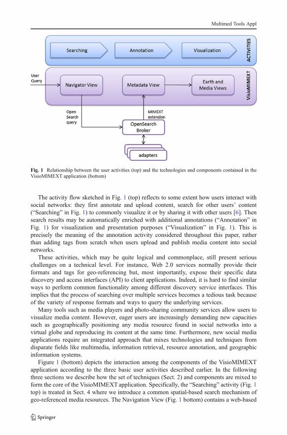
The activity flow sketched in Fig. 1 (top) reflects to some extent how users interact withsocial networks: they first annotate and upload content, search for other users’ content(“Searching” in Fig. 1) to commonly visualize it or by sharing it with other users [6]. Thensearch results may be automatically enriched with additional annotations (“Annotation” inFig. 1) for visualization and presentation purposes (“Visualization” in Fig. 1). This isprecisely the meaning of the annotation activity considered throughout this paper, ratherthan adding tags from scratch when users upload and publish media content into socialnetworks.
These activities, which may be quite logical and commonplace, still present seriouschallenges on a technical level. For instance, Web 2.0 services normally provide theirformats and tags for geo-referencing but, most importantly, expose their specific datadiscovery and access interfaces (API) to client applications. Indeed, it is hard to find similarways to perform common functionality among different discovery service interfaces. Thisimplies that the process of searching over multiple services becomes a tedious task becauseof the variety of response formats and ways to query the underlying services.
Many tools such as media players and photo-sharing community services allow users tovisualize media content. However, eager users are increasingly demanding new capacitiessuch as geographically positioning any media resource found in social networks into avirtual globe and reproducing its content at the same time. Furthermore, new social mediaapplications require an integrated approach that mixes technologies and techniques fromdisparate fields like multimedia, information retrieval, resource annotation, and geographicinformation systems.
Figure 1 (bottom) depicts the interaction among the components of the VisioMIMEXTapplication according to the three basic user activities described earlier. In the followingthree sections we describe how the set of techniques (Sect. 2) and components are mixed toform the core of the VisioMIMEXT application. Specifically, the “Searching” activity (Fig. 1top) is treated in Sect. 4 where we introduce a common spatial-based search mechanism ofgeo-referenced media resources. The Navigation View (Fig. 1 bottom) contains a web-based
Fig. 1 Relationship between the user activities (top) and the technologies and components contained in theVisioMIMEXT application (bottom)
Multimed Tools Appl
interface to support such a searching mechanism and utilizes internally the OpenSearchBroker and the set of adapters. The “Annotation” activity (Fig. 1 top) is discussed on Sect. 5where collections of searching results are annotated in an enhanced KML-based format(MIMEXT extension) designed for geo-referenced media resources. Finally, the Visualiza-tion” activity (Fig. 1 top) is presented in Sect. 6 where the VisioMIMEXT application is ableto visualize the collection of geo-referenced media resources on a virtual globe. In this case,the Metadata, Earth and Media Views (Fig. 1 bottom) components allow users to interpret,visualize, and reproduce geo-referenced media resources over the virtual globe.
4 Searching of geo-referenced media resources
Users have a growing interest in sharing heterogeneous, media content in social networks.This media content is uploaded into different Web 2.0 applications and services dependingon its nature. For instance, geo-tagged photographs can be shared through Flickr [17], whileshort text messages are shared via Twitter [55]. Nevertheless, despite the popularity of socialnetworks and social media services, there have not been many approaches that allow users tosearch for media content regardless of the nature of the underlying social networks andservices [40]. Indeed, most of these crowd-sourced online services have developed their ownfunctional API, and use specific encodings formats and schemas. Browsing and accessingsuch services to gain access to different varied media resources requires comprehensiveknowledge of every discovery service API. This constitutes a technical barrier for thediscovery of geo-referenced media content over several sources.
To overcome this problem our approach relies on the belief that users expect, and inreality are used to, search interfaces based on minimal input. Essentially, advanced querymight be desirable and even available but simple query capacities are mostly preferred byusers to search for the right content from a large number of possibilities. To illustrate thebenefits of minimal search interfaces, the “custom search” textbox-based tool available inmost of web browsers is a simple but interesting working discovery service that exemplifiesthe pragmatism and simplicity of Web 2.0 services [7]. Web users can easily customize thistool by choosing from a collection of on-line data repositories and services such as onlineshops, dictionaries, and general-purpose search engines. Independently of the data repositoryor service used, the query interface is always the same: users type in a term and obtain the listof results from Google, Amazon or Wikipedia.
This example represents the most widespread use case of the OpenSearch specification[12]. OpenSearch has rapidly become a successful query mechanism over thousands ofwebsites, services and repositories which are increasingly adapting it to expose theirsearching interfaces in a standard and simple manner. In this section we firstly describethe OpenSearch basic interface and the Geo extension, followed by a discussion on how wehave adopted OpenSearch as a common query interface that allows us to perform spatialqueries over social networks and services.
4.1 Keyword-based query pattern
OpenSearch provides minimal search and retrieval capabilities that any repository andservice should support. OpenSearch describes a basic search pattern that fits nicely intothe minimal search interfaces that identified most Web 2.0 services. An OpenSearch-enabledservice exposes an OpenSearch interface to inform client applications, such as the “customsearch” tool described earlier, as well as how to issue simple HTTP GET queries expanded
Multimed Tools Appl
with specific query parameters. As a result, responses are often encoded in lightweight dataformats such as GeoRSS [25], Atom [42], or KML [45].
The OpenSearch search interface has only one mandatory query parameter called“searchTerms” and allows client applications to retrieve resources that are related to oneor more keywords or search terms. Other query parameters like those supporting responsepagination (“count”, “startIndex”, “startPage”) are optional. On the server side, theOpenSearch-aware service performs a text-based search over the resource repository andtypically considers the following metadata descriptors for each target resource: title, author,description, and user-defined tags. It is worthwhile noting that the list of target metadatadescriptors depends on the specific service. For instance, Twitter, Flickr and YouTube [66]may share some descriptors but surely others are different.
4.2 Spatial-based query pattern
Although the keyword-based search pattern works well in many settings, advanced searchcriteria should be put in place via extensions or specialized profiles. In the OpenSearchcommunity, specific search profiles are described by extending the base OpenSearchcapabilities (Sect. 4.1). Among the extensions suggested,1 the Geo extension [54] definesa list of query parameters to enable geographic filtering. Spatial-based queries are thensupported through the proper combination of OpenSearch and its Geo extension searchinterface (OpenSearch-Geo).
The OpenSearch-Geo is built upon the basic OpenSearch specification, so all mandatoryand optional query parameters previously mentioned are also available. Apart from thesebase parameters, the OpenSearch-Geo extension defines some specific, optional queryparameters. The “box” parameter filters results from a rectangular area. The “lat”, “lon”and “radius” parameter filters result from a circular area around a point. The “geometry”parameter defines a geographic filter by means of an arbitrary geometry. The “name”parameter allows filtering by place name.
Although OpenSearch and OpenSearch-Geo specifications do not specify any mandatoryresponse format (but both recommend supporting at least the Atom format [42]), functionalresponses should attach geographic descriptions to each result item so that client applicationscan handle geo-referenced media resources. Common geographic response formats used incurrent OpenSearch-geo implementations are driven by two approaches. The first oneconsists of using existing non geo-specific formats, such as HTML, JSON (Java ScriptObject Notation) [34] and Atom [42]. In this case, these formats are enriched with geo-graphic annotations, such as the geo microformat [21] in HTML and the GeoRSS extensionin RSS (Really Simple Syndications) and Atom formats. The second approach is to usenative geographic-oriented formats such as KML. To provide a balanced approach, ourdecision was to support Atom for keyword-based queries, and Atom extended with GeoRSSand KML/MIMEXT KML for spatial-based queries, as described in the following section.
4.3 OpenSearch Broker
After reviewing the main characteristics of the OpenSearch interface, the focus of thissection is to describe how users can homogenously search over different social networksthrough the OpenSearch Broker component.
1 http://www.opensearch.org/Specifications/OpenSearch/Extensions
Multimed Tools Appl
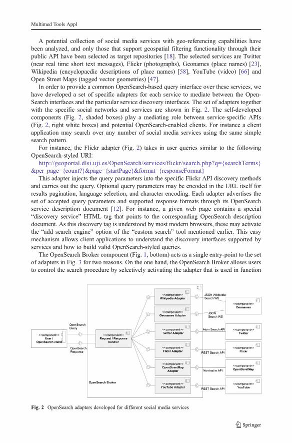
A potential collection of social media services with geo-referencing capabilities havebeen analyzed, and only those that support geospatial filtering functionality through theirpublic API have been selected as target repositories [18]. The selected services are Twitter(near real time short text messages), Flickr (photographs), Geonames (place names) [23],Wikipedia (encyclopaedic descriptions of place names) [58], YouTube (video) [66] andOpen Street Maps (tagged vector geometries) [47].
In order to provide a common OpenSearch-based query interface over these services, wehave developed a set of specific adapters for each service to mediate between the Open-Search interfaces and the particular service discovery interfaces. The set of adapters togetherwith the specific social networks and services are shown in Fig. 2. The self-developedcomponents (Fig. 2, shaded boxes) play a mediating role between service-specific APIs(Fig. 2, right white boxes) and potential OpenSearch-enabled clients. For instance a clientapplication may search over any number of social media services using the same simplesearch pattern.
For instance, the Flickr adapter (Fig. 2) takes in user queries similar to the followingOpenSearch-styled URI:
http://geoportal.dlsi.uji.es/OpenSearch/services/flickr/search.php?q0searchTerms&per_page0count?&page0startPage&format0responseFormat
This adapter injects the query parameters into the specific Flickr API discovery methodsand carries out the query. Optional query parameters may be encoded in the URL itself forresults pagination, language selection, and character encoding. Each adapter advertises theset of accepted query parameters and supported response formats through its OpenSearchservice description document [12]. For instance, a given web page contains a special“discovery service” HTML tag that points to the corresponding OpenSearch descriptiondocument. As this discovery tag is understood by most modern browsers, these may activatethe “add search engine” option of the “custom search” tool mentioned earlier. This easymechanism allows client applications to understand the discovery interfaces supported byservices and how to build valid OpenSearch-styled queries.
The OpenSearch Broker component (Fig. 1, bottom) acts as a single entry-point to the setof adapters in Fig. 3 for two reasons. On the one hand, the OpenSearch Broker allows usersto control the search procedure by selectively activating the adapter that is used in function
Fig. 2 OpenSearch adapters developed for different social media services
Multimed Tools Appl
to the query criteria. Users, via the OpenSearch client contained in the VisioMIMEXTapplication (see Sect. 6), can select one or various adapters or even the whole set. In thissense, the OpenSearch client within VisioMIMEXT plays the same role as the previousexample of the “custom search” tool within browsers.
On the other hand, since these social networks and media services offer specific discoveryinterfaces, they also provide different response formats. For instance, the Flickr adaptercollects the query results in Atom format while the Geonames adapter does so in JSONformat. The OpenSearch Broker thus collects and merges all search results into the sameformat (Atom, KML or MIMEXT) to be finally forwarded to client applications. The“broker-adapters” configuration is flexible enough because new adapters may be addedwithout altering the broker’s discovery interface from the client perspective. In doing so,clients and adapters are independent, loosely coupled components where each one evolvesseparately, enhancing the system scalability as a whole [43].
Although some social media services expose discovery interfaces through the Open-Search specification (Flickr, Wikipedia), these do not offer the OpenSearch-Geo searchinterface. The set of developed adapters and the OpenSearch Broker component supportspatial queries over those services that natively support, to some extent, geographic searchcapabilities through their own API. For instance, users can search for media resourcesrestricted to a given area of interest represented as a rectangular geometry (bounding box).
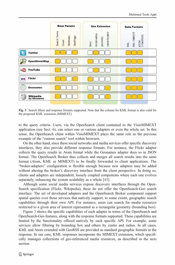
Figure 3 shows the specific capabilities of each adapter in terms of the OpenSearch andOpenSearch-Geo features, along with the response formats supported. These capabilities arelimited by the functionality offered natively by each specific API. For example, someservices allow filtering by bounding box and others by centre and radius. In all cases,KML and Atom extended with GeoRSS are provided as standard geographic formats in theresponse. In our case, KML responses incorporate the MIMEXT extension, which specifi-cally manages collections of geo-referenced media resources, as described in the nextsection.
Fig. 3 Search filters and response formats supported. Note that the column for KML format is also valid forthe proposed KML extension (MIMEXT)
Multimed Tools Appl

In terms of search accuracy and performance, the OpenSearch Broker depends completelyon the accuracy supported by the social networks and services queried. For instance, few tweetsare actually geo-referenced and their localization is determined by the user profile. In this sense,if a Twitter user does provide her location, her tweets cannot be searched with the spatial-basedcriteria proposed. In addition, the nature of each service leads to different constraints andrequirements in terms of discovery. For instance, Flickr resources can be queried over timewhile Twitter resources are only discoverable during a narrow time window. Indeed, these openissues pose new challenges in the field of social mining [49].
5 Enriching collections of geo-referenced multimedia resources
As commented earlier, the OpenSearch Broker component merges all the result sets into acollection of geo-referenced media resources. This collection is serialized into the KML-based extension language. In this section, we describe such a KML extension (MIMEXT)which is meant for grouping and visualizing different media resources on virtual globeapplications like VisioMIMEXT.
5.1 MIMEXT KML extension
The release of HTML5 introduces new multimedia tags to natively cover a great deal of mediacontent. We take a similar approach in extending KML to facilitate the integration of collectionsof geo-referenced multimedia resources that KML does not yet support. The proposed KMLextension called MIMEXT (MIME Extension) enhances KML in two aspects: better geo-referenced mechanism and support for a large variety of media types via annotation.
The extension and restriction for specific purposes of the standard OGC KML scheme ispossible via Application Profiles [45]. An Application Profile (AP) must adhere to certainconstraints, which ensures that the new tags are correctly derived from the base KMLelements. The proposed MIMEXT AP (MIMEXT for short) is built by inheritance, that is,the new elements and tags are derived from KML core abstract base types.
MIMEXT consists of new elements for geo-referencing media content and annotating theMIME type of resources. Regarding the first group, elements to accommodate geo-referencingcapabilities, they derive directly from the KML <Geometry> tag. This effectively permitsassociating this geometry with any media resources that are not currently supported by theKML standard.
Regarding the second group, additions made to register MIME types, the proposed elementsdeal with theMIME type of a given media resource and its file type extension. This informationmay be useful, not only for the end user but also for underlying client applications capable ofoffering a direct visualization of these resources. As we see in section 6, the VisioMIMEXTapplication is able to directly visualize such resources over a virtual globe or by delegating itscontrol to the corresponding application associated to the file type or extension.
The resource type description should follow the MIME type specifications [8, 19, 20]. Anextensive list of MIME types is defined,2 each one specifying their file type, subtype andextension. This has been taken as base for our approach in order to provide informationabout the resource in a way that is as standardized as possible.
2 http://www.iana.org/assignments/media-types/
Multimed Tools Appl
5.2 MIMEXT structure
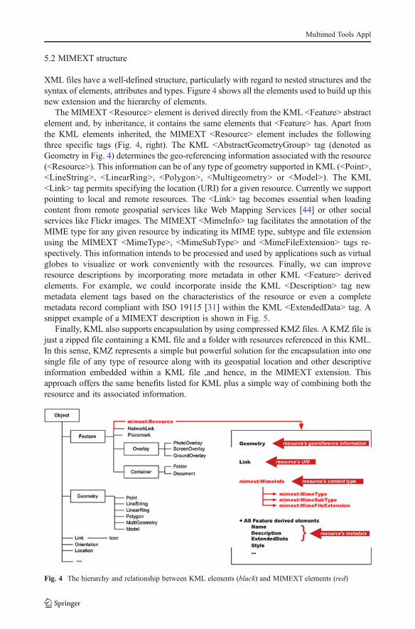
XML files have a well-defined structure, particularly with regard to nested structures and thesyntax of elements, attributes and types. Figure 4 shows all the elements used to build up thisnew extension and the hierarchy of elements.
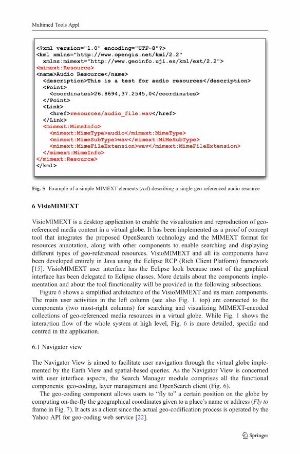
The MIMEXT <Resource> element is derived directly from the KML <Feature> abstractelement and, by inheritance, it contains the same elements that <Feature> has. Apart fromthe KML elements inherited, the MIMEXT <Resource> element includes the followingthree specific tags (Fig. 4, right). The KML <AbstractGeometryGroup> tag (denoted asGeometry in Fig. 4) determines the geo-referencing information associated with the resource(<Resource>). This information can be of any type of geometry supported in KML (<Point>,<LineString>, <LinearRing>, <Polygon>, <Multigeometry> or <Model>). The KML<Link> tag permits specifying the location (URI) for a given resource. Currently we supportpointing to local and remote resources. The <Link> tag becomes essential when loadingcontent from remote geospatial services like Web Mapping Services [44] or other socialservices like Flickr images. The MIMEXT <MimeInfo> tag facilitates the annotation of theMIME type for any given resource by indicating its MIME type, subtype and file extensionusing the MIMEXT <MimeType>, <MimeSubType> and <MimeFileExtension> tags re-spectively. This information intends to be processed and used by applications such as virtualglobes to visualize or work conveniently with the resources. Finally, we can improveresource descriptions by incorporating more metadata in other KML <Feature> derivedelements. For example, we could incorporate inside the KML <Description> tag newmetadata element tags based on the characteristics of the resource or even a completemetadata record compliant with ISO 19115 [31] within the KML <ExtendedData> tag. Asnippet example of a MIMEXT description is shown in Fig. 5.
Finally, KML also supports encapsulation by using compressed KMZ files. A KMZ file isjust a zipped file containing a KML file and a folder with resources referenced in this KML.In this sense, KMZ represents a simple but powerful solution for the encapsulation into onesingle file of any type of resource along with its geospatial location and other descriptiveinformation embedded within a KML file ,and hence, in the MIMEXT extension. Thisapproach offers the same benefits listed for KML plus a simple way of combining both theresource and its associated information.
Fig. 4 The hierarchy and relationship between KML elements (black) and MIMEXT elements (red)
Multimed Tools Appl
6 VisioMIMEXT
VisioMIMEXT is a desktop application to enable the visualization and reproduction of geo-referenced media content in a virtual globe. It has been implemented as a proof of concepttool that integrates the proposed OpenSearch technology and the MIMEXT format forresources annotation, along with other components to enable searching and displayingdifferent types of geo-referenced resources. VisioMIMEXT and all its components havebeen developed entirely in Java using the Eclipse RCP (Rich Client Platform) framework[15]. VisioMIMEXT user interface has the Eclipse look because most of the graphicalinterface has been delegated to Eclipse classes. More details about the components imple-mentation and about the tool functionality will be provided in the following subsections.
Figure 6 shows a simplified architecture of the VisioMIMEXT and its main components.The main user activities in the left column (see also Fig. 1, top) are connected to thecomponents (two most-right columns) for searching and visualizing MIMEXT-encodedcollections of geo-referenced media resources in a virtual globe. While Fig. 1 shows theinteraction flow of the whole system at high level, Fig. 6 is more detailed, specific andcentred in the application.
6.1 Navigator view
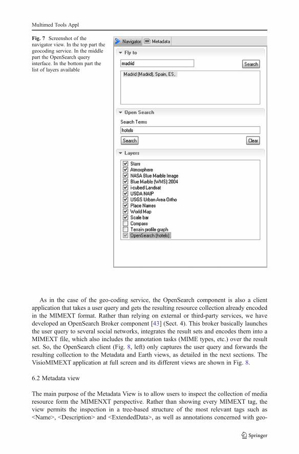
The Navigator View is aimed to facilitate user navigation through the virtual globe imple-mented by the Earth View and spatial-based queries. As the Navigator View is concernedwith user interface aspects, the Search Manager module comprises all the functionalcomponents: geo-coding, layer management and OpenSearch client (Fig. 6).
The geo-coding component allows users to “fly to” a certain position on the globe bycomputing on-the-fly the geographical coordinates given to a place’s name or address (Fly toframe in Fig. 7). It acts as a client since the actual geo-codification process is operated by theYahoo API for geo-coding web service [22].
Fig. 5 Example of a simple MIMEXT elements (red) describing a single geo-referenced audio resource
Multimed Tools Appl

The concept of overlapped layers on the virtual globe is managed by the Layer Manage-ment (Layers frame in Fig. 7), which enables and disables any viewable layer in the list box.It is worth noting that search results are cached and treated as a layer. One may disable asearching layer and enable it further without carrying out the query again. For instance, theOpenSearch (hotels) layer listed in Fig. 7 represents the resulting list of geo-referencedmedia content annotated with the geo-tag hotels and located around the Madrid area.
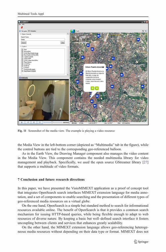
The OpenSearch component allows users to search for media resources through theOpenSearch protocol and its Geo extension (Sect. 4). As commented earlier, queries canbe based on keywords, on a geographic area of interest (bounding box), or both. Keyword-based queries are typed directly by the user in the OpenSearch frame (Fig. 7 in detail and leftside of Fig. 8), while the area of interest is automatically set in the query as the active view ofthe virtual globe (Fig. 8, right). For instance, when zooming in at the Madrid level by the“fly to” functionality, this geographic area is injected in the box query parameter so that onlyresources restricted to that area are retrieved. While search terms are explicitly typed byusers, spatial-based search criteria are automatically bound to the current zoom level (visiblegeographic area) in the Earth View (Fig. 8).
Fig. 6 The VisioMIMEXT architecture combines user activities, VisioMIMEXT user interfaces (views), andinternal components
Multimed Tools Appl
As in the case of the geo-coding service, the OpenSearch component is also a clientapplication that takes a user query and gets the resulting resource collection already encodedin the MIMEXT format. Rather than relying on external or third-party services, we havedeveloped an OpenSearch Broker component [43] (Sect. 4). This broker basically launchesthe user query to several social networks, integrates the result sets and encodes them into aMIMEXT file, which also includes the annotation tasks (MIME types, etc.) over the resultset. So, the OpenSearch client (Fig. 8, left) only captures the user query and forwards theresulting collection to the Metadata and Earth views, as detailed in the next sections. TheVisioMIMEXT application at full screen and its different views are shown in Fig. 8.
6.2 Metadata view
The main purpose of the Metadata View is to allow users to inspect the collection of mediaresource form the MIMENXT perspective. Rather than showing every MIMEXT tag, theview permits the inspection in a tree-based structure of the most relevant tags such as<Name>, <Description> and <ExtendedData>, as well as annotations concerned with geo-
Fig. 7 Screenshot of thenavigator view. In the top part thegeocoding service. In the middlepart the OpenSearch queryinterface. In the bottom part thelist of layers available
Multimed Tools Appl

referencing and MIME types. All the resources listed in Fig. 9 can be mapped on the virtualglobe because both views (Earth and Metadata) are synchronized.
The functionality of the Metadata View is delegated to the File Manager component,which is responsible for processing (parsing) and interpreting KML and MIMEXT files.
Parsingmethods read the incoming search results and interpret the structure and semantics ofthe MIMEXT tags. After studying some KML parsing options, JAK (Java API for KML) [33]
Fig. 8 Screenshot of the main interface. The example shows geo-referenced media resources on the virtualglobe retrieved using the search term hotels in the Madrid area
Fig. 9 Screenshot of the metadata view. The example shows the retrieved resources in MIMEXT format in atree-based format for inspecting their elements and tags
Multimed Tools Appl
was the parsing library of choice. In contrast to the popular libKML library [38], JAK offers afull implementation of the KML standard and also supports extensibility, which makes itsuitable for implementing parsers for KML extensions like MIMEXT.
The File Manager can also compress/uncompress KMZ files and load their content on thevirtual globe. Conversely, a MIMEXT file may be compressed for sharing and exchanging acollection of media resources in just one file.
6.3 Earth view
To tackle visualization and multimedia issues, the VisioMIMEXT tool provides the Earthand Media Views. The former provides a 3D model of the Earth and displays most of themedia resources. The latter is a specialized view for reproducing certain types of mediacontent that cannot be viewed directly on the virtual globe.
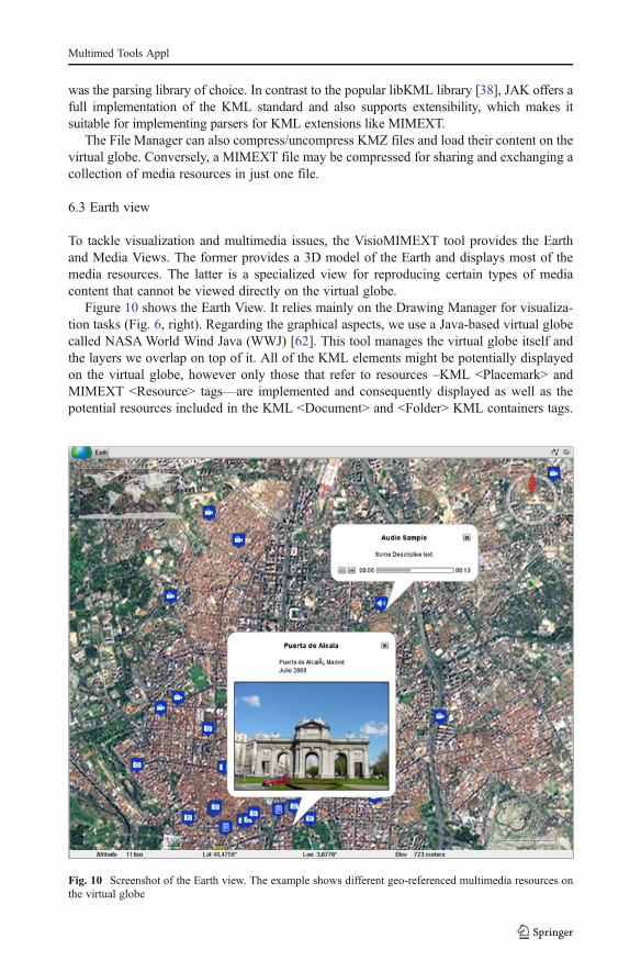
Figure 10 shows the Earth View. It relies mainly on the Drawing Manager for visualiza-tion tasks (Fig. 6, right). Regarding the graphical aspects, we use a Java-based virtual globecalled NASAWorld Wind Java (WWJ) [62]. This tool manages the virtual globe itself andthe layers we overlap on top of it. All of the KML elements might be potentially displayedon the virtual globe, however only those that refer to resources –KML <Placemark> andMIMEXT <Resource> tags—are implemented and consequently displayed as well as thepotential resources included in the KML <Document> and <Folder> KML containers tags.
Fig. 10 Screenshot of the Earth view. The example shows different geo-referenced multimedia resources onthe virtual globe
Multimed Tools Appl

For instance, the Metadata View in Fig. 9 shows the list of <Resources> tags nested in the<Document> container.
The geographic representation of these KML tags is based on the geo-referencingannotation. This information contains both geometry like points and polygons and alsorelated resources such as icons used to visually identify the type of resource. Figure 10 forinstance shows two different icons associated to audio and photo resources.
We encountered some limitations in the way WWJ’s geometric methods transformdescriptive KML geometries (<Point>, <Line>, <Polygon> and <LinearRing>) into theircounterpart graphical forms. WWJ is based on OpenGL primitives [63] for renderinggeometric representation on the globe. The main issue was that neither WWJ nor OpenGLdid not support natively KML format, which means that there was no direct equivalencebetween KML geometries and OpenGL geometries primitives.
We addressed this issue by extending the WWJ tool with KML (and MIMEXT) support.In doing so, we were able to interpret KML geometry, transform it into OpenGL primitives,and finally display the results on the virtual globe. In particular, we rely on the JOGL (Javabindings for OpenGL) [36] which allows us to adapt any source geometry to the targetOpenGL geometric primitives. For instance a KML <LinearRing> tag can be represented inOpenGL as a line with the same first and last point.
The Drawing Manager component also manages the graphical representation of the typeof the media resources. For instance, a video resource uses an icon different from a photoresource (Fig. 10). This is usually known as annotations in WWJ or balloons in GoogleEarth. Here, the term WWJ annotations would refer to balloons3 normally used for repre-senting, customizing or categorizing a resource on the virtual globe. WWJ balloons supportthe visualization of certain media types such as text, although more complex media typeslike video and audio are not supported. For this reason, the Drawing Manager also includes aset of classes (called Balloons Mgmt in Fig. 6), whose aim is to extend the source balloonsdefined in WWJ and permit the representation of the different geo-referenced mediaresources on the virtual globe, depending on their nature or type. For example, we havedifferent extended balloons for audio and image resources: audio annotations integrate asimple player to reproduce the resource and the image annotations can show the image itself(Fig. 10).
By clicking on a given icon, a balloon is opened and the selected media resource is shownor reproduced in the case of an audio file. However, some media types entail additionalcomplexity which makes it hard to visualize the resource within the balloon. In these cases,we have designed the Media View.
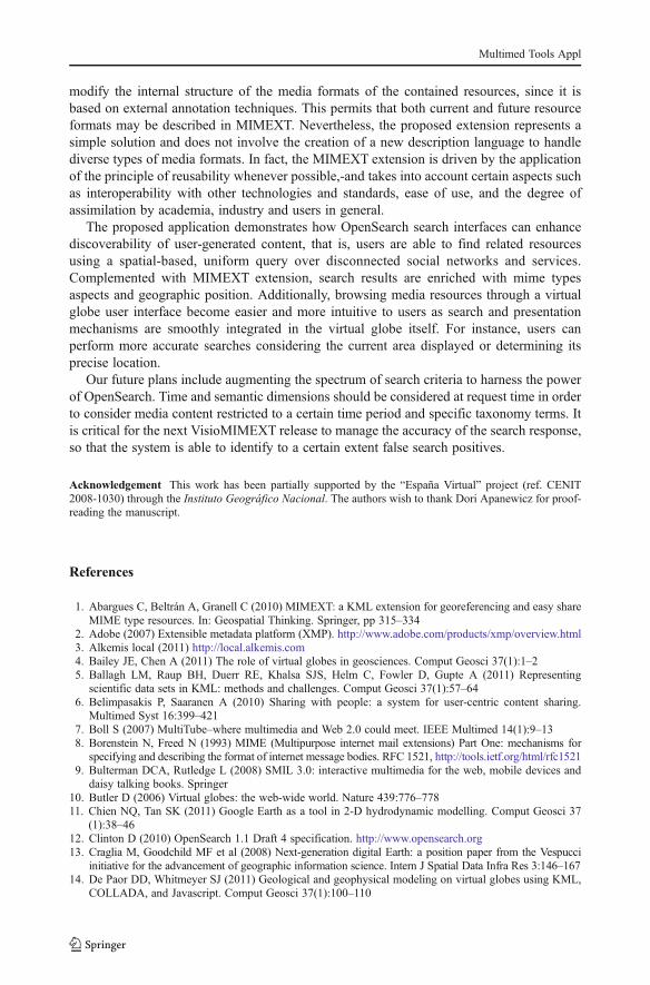
6.4 Media view
The Media View module plays all content that, for technical reasons, cannot be reproduceddirectly on the virtual globe; we are particularly referring to video resources. The problemcomes from the inherent limitations in OpenGL scenes. As WWJ is based on this graphiclibrary, any element displayed on the virtual globe must adhere to the OpenGL constraints,which unavoidably impedes the proper reproduction of video content [59, 63].
The Media View is thus suggested as a workaround. The balloons for video resourcesincludes buttons that allow users to control the reproduction, yet the reproduction of thevideo content takes place in a separate view different from the Earth View. Figure 11 shows
3 We hereafter use the term balloon rather than WWJ annotation to avoid confusion.
Multimed Tools Appl
the Media View in the left-bottom corner (depicted as “Multimedia” tab in the figure), whilethe control buttons are tied to the corresponding geo-referenced balloon.
As in the Earth View, the Drawing Manager component also manages the video contentin the Media View. This component contains the needed multimedia library for videomanagement and playback. Specifically, we used the open source GStreamer library [27]that supports a multitude of video formats.
7 Conclusion and future research directions
In this paper, we have presented the VisioMIMEXT application as a proof of concept toolthat integrates OpenSearch search interfaces MIMEXT extension language for media anno-tation, and a set of components to enable searching and the presentation of different types ofgeo-referenced media resources on a virtual globe.
On the one hand, OpenSearch is a simple but standard method to search for informationalresources available online. The benefit of OpenSearch is that it provides a common searchmechanism for issuing HTTP-based queries, while being flexible enough to adapt to webresources of diverse nature. By keeping a basic but well–defined search interface it fostersuncoupling between clients and services that enhances greatly scalability.
On the other hand, the MIMEXT extension language allows geo-referencing heteroge-neous media resources without depending on their data type or format. MIMEXT does not
Fig. 11 Screenshot of the media view. The example is playing a video resource
Multimed Tools Appl
modify the internal structure of the media formats of the contained resources, since it isbased on external annotation techniques. This permits that both current and future resourceformats may be described in MIMEXT. Nevertheless, the proposed extension represents asimple solution and does not involve the creation of a new description language to handlediverse types of media formats. In fact, the MIMEXT extension is driven by the applicationof the principle of reusability whenever possible,-and takes into account certain aspects suchas interoperability with other technologies and standards, ease of use, and the degree ofassimilation by academia, industry and users in general.
The proposed application demonstrates how OpenSearch search interfaces can enhancediscoverability of user-generated content, that is, users are able to find related resourcesusing a spatial-based, uniform query over disconnected social networks and services.Complemented with MIMEXT extension, search results are enriched with mime typesaspects and geographic position. Additionally, browsing media resources through a virtualglobe user interface become easier and more intuitive to users as search and presentationmechanisms are smoothly integrated in the virtual globe itself. For instance, users canperform more accurate searches considering the current area displayed or determining itsprecise location.
Our future plans include augmenting the spectrum of search criteria to harness the powerof OpenSearch. Time and semantic dimensions should be considered at request time in orderto consider media content restricted to a certain time period and specific taxonomy terms. Itis critical for the next VisioMIMEXT release to manage the accuracy of the search response,so that the system is able to identify to a certain extent false search positives.
Acknowledgement This work has been partially supported by the “España Virtual” project (ref. CENIT2008-1030) through the Instituto Geográfico Nacional. The authors wish to thank Dori Apanewicz for proof-reading the manuscript.
References
1. Abargues C, Beltrán A, Granell C (2010) MIMEXT: a KML extension for georeferencing and easy shareMIME type resources. In: Geospatial Thinking. Springer, pp 315–334
2. Adobe (2007) Extensible metadata platform (XMP). http://www.adobe.com/products/xmp/overview.html3. Alkemis local (2011) http://local.alkemis.com4. Bailey JE, Chen A (2011) The role of virtual globes in geosciences. Comput Geosci 37(1):1–25. Ballagh LM, Raup BH, Duerr RE, Khalsa SJS, Helm C, Fowler D, Gupte A (2011) Representing
scientific data sets in KML: methods and challenges. Comput Geosci 37(1):57–646. Belimpasakis P, Saaranen A (2010) Sharing with people: a system for user-centric content sharing.
Multimed Syst 16:399–4217. Boll S (2007) MultiTube–where multimedia and Web 2.0 could meet. IEEE Multimed 14(1):9–138. Borenstein N, Freed N (1993) MIME (Multipurpose internet mail extensions) Part One: mechanisms for
specifying and describing the format of internet message bodies. RFC 1521, http://tools.ietf.org/html/rfc15219. Bulterman DCA, Rutledge L (2008) SMIL 3.0: interactive multimedia for the web, mobile devices and
daisy talking books. Springer10. Butler D (2006) Virtual globes: the web-wide world. Nature 439:776–77811. Chien NQ, Tan SK (2011) Google Earth as a tool in 2-D hydrodynamic modelling. Comput Geosci 37
(1):38–4612. Clinton D (2010) OpenSearch 1.1 Draft 4 specification. http://www.opensearch.org13. Craglia M, Goodchild MF et al (2008) Next-generation digital Earth: a position paper from the Vespucci
initiative for the advancement of geographic information science. Intern J Spatial Data Infra Res 3:146–16714. De Paor DD, Whitmeyer SJ (2011) Geological and geophysical modeling on virtual globes using KML,
COLLADA, and Javascript. Comput Geosci 37(1):100–110
Multimed Tools Appl
15. Eclipse RCP framework (2011) http://www.eclipse.org/home/categories/rcp.php16. Editorial N (2008) A place for everything. Nature 453(2):217. Flickr.com (2011) http://www.flickr.com18. Fonts O, Huerta J, Díaz L, Granell C (2009).OpenSearch-geo: the simple standard for geographic search
engines. Proceedings IV Jornadas SIG Libre19. Freed N, Borenstein N (1996a) Multipurpose internet mail extensions (mime) part one: format of internet
message bodies, RFC 2045. http://tools.ietf.org/html/rfc204520. Freed N, Borenstein N (1996b) Multipurpose internet mail extensions (MIME) part two: media types,
RFC 2046. http://tools.ietf.org/html/rfc204621. Geo microformat (2011) http://microformats.org/wiki/geo22. Yahoo! Maps Web Services - Geocoding API (2011) http://developer.yahoo.com/maps/rest/V1/geocode.html23. Geonames (2011) http://www.geonames.org24. Geonetwork Developers (2009) GeoNetwork opensource: the complete manual. http://geonetwork-opensource.
org/_static/geonetwork24_eng.pdf25. GeoRSS (2011) http://www.georss.org/Main_Page26. Google Earth (2011) http://earth.google.com27. GStreamer—Open source multimedia framework (2011) http://gstreamer.freedesktop.org/28. Hobona G, James P, Fairbairn D (2006) Web-based visualization of 3D geospatial data using Java3D.
IEEE Comput Graph Appl 26(4):28–3329. Huang B, Jiang B, Li H (2001) An integration of GIS, virtual reality and the internet for visualization,
analysis and exploration of spatial data. Int J Geogr Inf Sci 15(5):439–45630. International Press Telecommunications Council (2009) IPTC photo metadata standard. IPTC, Core 1.1
and IPTC Extesion 1.1 Tech rep31. ISO (2003) ISO 19115: geographic information - metadata, International Organization for Standardization
(ISO)32. Ivanov I, Vajda P, Lee J-S, Goldmann L, Ebahimi T (2012) Geotag propagation in social networks based
on user trust model. Multimed Tool Appl 56(1):155–17733. Jak – Java API for KML (2011) http://code.google.com/p/javaapiforkml/34. Json - Java Script Object Notation (2011) http://www.json.org35. JEITA (2002) Exchangeable image file format for digital still cameras: Exif Version 2.2. Technical
Standardization Committee on AV & IT Storage Systems and Equipment. Tech Report JEITA (JapanElectronics and Information Technology Industries Association) CP-3451
36. Jogl - Java bindings for OpenGL (2011) http://java.net/projects/jogl/37. Joshi D, Gallagher A, Yu J, Luo J (2012) Inferring photographic location using geotagged web images.
Multimed Tool Appl 56(1):131–15338. Libkml – KML library (2011) http://code.google.com/p/libkml/39. Luo J, Joshi D, Yu J, Gallangher A (2011) Geotaging in multimedia and computer vision-a survey.
Multimed Tool Appl 51(1):187–21140. Naaman M (2012) Social multimedia: highlighting opportunities for search and mining of multimedia
data in social media applications. Multimed Tool Appl 56(1):9–3441. Nogueras-Iso J, Zarazaga-Soria FJ, Béjar R, Álvarez PJ, Muro-Medrano PR (2005) OGC Catalog
services: a key element for the development of spatial data infrastructures. Comput Geosci 31(2):199–209
42. Nottingham M, Syare R (2005) The atom syndication format. RFC 4287, http://tools.ietf.org/html/rfc4287
43. Nuñez M, Díaz L, Granell C, Huerta J (2011) Web 2.0 Broker: a tool for massive collection of userinformation. Accepted to European Geosciences Union (EGU) General Assembly 2011 (EGU 2011),Vienna, Austria
44. OGC WMS (2006) OpenGIS Web Map Server Implementation Specification, Version 1.3.0. Open Geo-spatial Consortium Inc (Open GIS Consortium Inc). http://www.opengeospatial.org/standards/wms
45. OGC KML (2008) OpenGIS Keyhole Markup Language (KML) Implementation Specification, Version2.2.0. Open Geospatial Consortium Inc (Open GIS Consortium Inc). http://www.opengeospatial.org/standards/kml
46. Open Geospatial Consortium (2011) http://www.opengeospatial.com47. Open Street Maps (2011) http://www.openstreetmaps.org48. Programmable Web (2011) http://www.programmableweb.com49. Russell MA (2011) Mining the social web. O’Reilly Media, Sebastapol50. Schreer O, Feldmann I, Alonso Mediavilla I, Concejero P, Sadka AH, Rafiq Swash M, Benini S, Leonardi
R, Janjusevic T, Izquierdo E (2010) RUSHES – an annotation and retrieval engine for multimediasemantic units. Multmed Tool Appl 48:23–49
Multimed Tools Appl
51. Sheppard SRJ, Cizek P (2009) The ethics of Google Earth: crossing thresholds from spatial data tolandscape visualisation. J Environ Manag 90(6):2102–2117
52. Tomaszewski B (2011) Situation awareness and virtual globes: applications for disaster management.Comput Geosci 37(1):86–92
53. Tsai FS (2011) Web-based geographic search engine for location-aware search in Singapore. Expert SystAppl 38:1011–1016
54. Turner A (2010) The OpenSearch Geo extension (draft 2). http://www.opensearch.org/Specifications/OpenSearch/Extensions/Geo/1.0/Draft_2
55. Twitter (2011) http://twitter.com56. VRML - Virtual Reality Modelling Language (2011) http://www.w3.org/MarkUp/VRML/57. Walsh J (2007) On Spatial Data Search. Terradue White Paper. http://www.terradue.com/images/
T2-Research-07-003-OnSearch.pdf58. Wikipedia (2011) http://www.wikipedia.org59. Woo M, Neider J, Davis T, Shreiner D (1999) OpenGL programming guide: the official guide to learning
OpenGL. Addison-Wesley Professional60. Wood J, Dykes J, Slingsby A, Clarke K (2007) Interactive visual exploration of a large spatio-
temporal dataset: reflections on a geovisualization mashup. IEEE Trans Vis Comput Graph 13(6):1176–1183
61. World Wind Central (2011) http://worldwindcentral.com62. World Wind Java SDK (2011) http://worldwind.arc.nasa.gov/java/63. Wright R, Haemel N, Sellers G, Lipchak B (2004) OpenGL SuperBible. Addison-Wesley Professional64. Wu H, He Z, Gong J (2010) A virtual globe-based 3D visualization and interactive framework for public
participation in urban planning processes. Comput Environ Urban Syst 34(4):291–29865. Yamagishi Y, Yanaka H, Suzuki K, Tsuboi S, Isse T, Obayashi M, Tamura H, Nagao H (2010)
Visualization of geosciences data on Google Earth: development of a data converter system for seismictomographic. Comput Geosci 36(3):373–382
66. YouTube (2011) http://youtube.com67. Zhang J, Gong J, Lin H, Wang G, Huang J, Zhu J, Xu B, Teng J (2007) Design and development
of distributed virtual geographic environment system based on web services. Inf Sci 177:2968–3980
68. Zhu Q, Li D, Zhang Y, Zhong Z, Huang D (2002) CyberCity GIS (CCGIS): integration of DEMs, images,and 3D models. Photogramm Eng Remote Sens 68(4):361–367
Arturo Beltran is a PhD student and researcher at Universitat Jaume I of Castellón (Spain), where hegraduated in Computer Engineering (2007) and obtained his Master in Intelligent Systems (2009). His lines ofresearch are centered on Geographic Information Systems (GIS), Spatial Data Infrastructures (SDI), interop-erability, metadata and the description, indexing and discovery of multimedia resources. He has participated inseveral public funded research projects, the most important of which is the Spanish project “España Virtual”funded by Cenit Programme.
Multimed Tools Appl
Carlos Abargues graduated in Computer Engineering (2010) from Universitat Jaume I of Castellón (Spain).He obtained a Master in .NET Technologies (2008) at Universitat Oberta of Catalunya and a Master in Sciencedegree in Geospatial Technologies (2009) as a joint degree by the Universitat Jaume I, Universität Münsterand Universidade Noba de Lisboa. He has participated in national projects such as “España Virtual”researching in the improvement on discovery of geographic content and the description of collectionscomposed by heterogeneous resources including geographic information. His research also includes the useof new methods for geo-referencing heterogeneous types of geospatial data. He has currently delegated theGIS research as a hobby and he has recently started working as programmer for a consulting company inValencia, Spain.
Dr. Carlos Granell is a postdoctoral researcher at the Institute of New Imaging Technologies, UniversitatJaume I of Castellón (Spain), where he graduated in Computer Engineering (2000) and received his doctoratein Computer Science (2006). His research lines are centred on Spatial Data Infrastructures (SDI), interoper-ability, geoprocessing services, composition and reuse of geographic services, and architectural styles. He hastaken part in several public funded research projects and has carried out research stages at SINTEF (Norway),at Faculty of Geo-Information Science and Earth Observation of University of Twente (The Netherlands) andat University of Nottingham (UK).
Multimed Tools Appl
Manuela Núñez Redó received her MSc in Computer Science from the Universitat Jaume I of Castellón in2006. She has also obtained a Master’s Degree in Intelligent Systems from the University Jaume I in 2008. InDecember 2001, she started working at the European Council for Nuclear Research (CERN) in Geneva,Switzerland, where she worked for 2 years in the IT Department. In 2005, she was granted an Erasmusscholarship to study at ENSSAT (École Nationale Supérieure des Sciences Appliquées et de Technologie) inLannion, France. From 2006 to 2010, she worked in the Department of Computer Languages and Systems atUniversity Jaume I. Currently, she is a PhD student and she is a researcher at INIT (Institute of New ImagingTechnologies) where her research areas of interest are Geographic Information Systems (GIS), ComputerVision and Augmented Reality.
Dr. Laura Díaz graduated in Computer Engineering (2000) from the Universitat de Valencia. She obtainedher Master in Intelligent Systems (2008) and received her doctorate in Geospatial Science (2010) atUniversitat Jaume I of Castellón (Spain) where she is currently a postdoctoral researcher. Her research linesare novel approaches for improving geoservices descriptions and deployment, distributed geoprocessing andservice interoperability. She has participate in R&D projects, working for the Institute of Robotics of theUniversitat de Valencia and specialist companies in Geospatial Information Systems such as Geodan (TheNetherlands) and Iver TI (Spain). ESMI, AWARE, and currently EuroGEOSS are among the most importantinternational projects she has taken part in.
Multimed Tools Appl
Prof. Joaquín Huerta is an associate professor in the Department of Information Systems at UniversitatJaume I of Castellón (Spain), where he teaches GIS and Internet Technologies. He holds a bachelor and amaster in Computer Science and a master in CAD/CAM from the Polytechnic University of Valencia and aPhD in Computer Science from the University Jaume I of Castellón. He is currently the Director of theGeospatial Information Research Group and is leading several EU and National projects. His current researchinterests are Geospatial Technologies and Computer Graphics. He is also Director and co-founder of theMaster in Geospatial Technologies funded by Erasmus Mundus program. In addition to academic activitiesProf. Huerta is founding board member of an Internet service provider and, thus, possesses considerablebusiness experience as well as experience in systems integration
Multimed Tools Appl