a study on roof point extraction based on...
TRANSCRIPT
Journal of the Chinese Institute of Engineers, Vol. 31, No. 4, pp. 537-550 (2008) 537
A STUDY ON ROOF POINT EXTRACTION BASED ON ROBUST
ESTIMATION FROM AIRBORNE LIDAR DATA
Shih-Hong Chio
ABSTRACT
The airborne LIDAR scanning system is a whole new surveying technique thatcaptures extremely detailed and abundant terrain surface information. Terrain infor-mation is implied in airborne LIDAR data. Roof points are especially important inairborne LIDAR data for 3-D building reconstruction. The key point for automati-cally and reliably extracting roof points from airborne LIDAR data is how to excludeirrelevant non-roof points. Robust estimation is a theory about how to remove blun-ders from observations. If the non-roof points are viewed as blunders, it is possible todevelop an algorithm to acquire the roof points, based on robust estimation theory.This paper will therefore study how to develop an algorithm to acquire those roofLIDAR points and remove irrelevant non-roof LIDAR points, based on robust estima-tion theory. Problems relevant to the proposed algorithm will be investigated in thisstudy through experiments in order to understand the feasibility of the proposed algo-rithm and to further develop an automatic algorithm to extract roof points from air-borne LIDAR data.
Key Words: LIDAR data, building reconstruction, robust estimation, quadtreesplit-and-merge.
*Corresponding author. (Tel: 886-2-29393091; Fax: 886-2-29390251; Email: [email protected])
S. H. Chio is with the Department of Land Economics, NationalChengchi University, 64, Chih-Nan Rd., Sec. 2, Wenshan, Taipei11623, Taiwan.
I. INTRODUCTION
The airborne LIDAR (short for Light DetectionAnd Ranging) scanning system is a whole new sur-veying technique that captures extremely detailed andabundant terrain surface information (Ackermann,1999; Wehr and Lohr, 1999). Therefore a lot of ter-rain information is implied in airborne LIDAR data.Many algorithms have been developed and proposedto extract important terrain information, such as thedigital elevation model, the 3-D building model, andtrees (Axelsson, 1999; Axelsson, 2000; Haala andBrenner, 1999; Maas and Vosselman, 1999; Priestnallet al., 2000; Vosselman and Dijkman, 2001). For 3-D building models, roof points or planes in airborneLIDAR data should first be extracted . Most of themethods transform distributed LIDAR data into grid
data through interpolation procedures and then applyimage processing techniques to detect and extractthem (Geibel and Stilla, 2000; Maas and Vosselman,1999). Thus, some important spatial information, es-pecially relating to height accuracies, may be lost(Axelsson, 2000). For this reason, some of these al-gorithms were developed using original airborne LI-DAR data (Ackermann, 1999; Alharthy and Bethel,2002; Elberink and Mass, 2000; Haala and Brenner,1999; Priestnall et al., 2000; Roggero, 2002; Schuster,2004; Woo et al., 2002; Vosselman and Dijkman,2001). For example, Lee (2002) applies perceptualorganization to analyze geometric structures of air-borne LIDAR data in space and groups them intoplanes. Roggero (2002) proposes a region-growing-based segmentation that is feature based and isfounded on principle component analysis of the staticmoments. Schuster (2004) presents an investigationon the use of Tensor Voting for categorizing LIDARdata into outliers, line elements (e.g. high-voltagepower lines), surface patches (e.g. roofs), and volu-metric elements (e.g. vegetation); that is, segmenta-t ion of LIDAR data using the tensor vot ing
538 Journal of the Chinese Institute of Engineers, Vol. 31, No. 4 (2008)
framework. Wang and Tseng (2004) present anoctree-structure-based split-and-merge segmentationalgorithm for organizing airborne LIDAR point clouddata into clusters of 3-D planes. Although the use oforiginal airborne LIDAR data can keep the originalaccuracies, some difficulties still exist with roof pointextraction from airborne LIDAR data. The challeng-ing tasks are how to exclude the irrelevant points andhow to extract roof points reliably and automatically.Additionally, no-one has yet developed an algorithmto extract roof points on the basis of blunder detection.In fact, the isolation of non-roof LIDAR points fromcoplanar roof LIDAR points can utilize the theory ofblunder detection. In other words, non-roof LIDARpoints can be viewed as blunders and removed dur-ing the extraction of roof points. Robust estimationis simply a theory about how to remove blunders fromobservations. Huber (1981) states that robustness sig-nifies insensitivity to small deviations from theassumptions. Primarily, this is concerned with distri-butional robustness: the shape of the true underlyingdistribution deviates slightly from the assumed model(usually the Gaussian law). The term “robust esti-mation” in this study means estimation techniques thatare robust with respect to the presence of gross er-rors in the data. In this context, gross errors are de-fined as observations that do not fit the stochasticmodel of parameter estimation. Although the meth-ods of Roggero (2002) and Schuster (2004) are robust,the meaning of “robust” in the methods of Roggero(2002) and Schuster (2004) is different from that inHuber (1981). This paper therefore presents a methodof roof point extraction based on robust estimationand examines how to develop an algorithm for ac-quiring 3-D roof points from airborne LIDAR datafrom the perspective of blunder detection. For thefirst step, to roughly identify the locations and ap-proximate area outlines of the roof(s) from pure air-borne LIDAR data, aerial images with known orien-tation together with original LIDAR data are used togenerate the orthoimages. Then, using a computermouse device, the user depicts the approximate areaout l ines of the roof(s ) on the or thoimages .Afterwards, on the assumption that roofs are com-posed of either horizontal or slope planes, some moreaccurate plane information, called GRID planes, isextracted from the LIDAR data that is extracted ac-cording to the approximate area outlines using leastsquares fitting, based on quadtree splitting (cf. Wangand Tseng, 2004). These GRID planes will be fur-ther merged using quadtree merging, according to theheight constraints for providing SEED regions formerging the adjacent points, using the forward selec-tion robust estimation approach (see Section II.3) toextract all the coplanar roof points. If only one roofexists, only one GRID plane is extracted. In this case,
the SEED region is the GRID plane. Thus, the SEEDregion contains all the points in the approximate areaoutline. No matter how many roofs exist, the groundelevation is calculated and used to exclude non-roofSEED regions before they are used to merge adjacentpoints. In the proposed algorithm, it is essential forroof points to be reliably acquired; therefore, irrel-evant points are considered as outliers and removedthrough robust estimation theory (Kubik et al., 1986)to merge adjacent roof points. Section II will describeleast squares fitting based on robust estimation theoryfor coplanar point extraction from airborne LIDARdata. The proposed algorithm will be presented inSection III. The experiments and results will be dis-cussed and illustrated in Section IV. Finally, con-clusions and suggestions for future research will bemade in Section V.
II. COPLANAR POINT EXTRACTIONTHROUGH ROBUST ESTIMATION THEORY
This section explains how to extract coplanarpoints by least squares fitting based on robust esti-mation theory. Section II.1 describes how to extractcoplanar points from sufficient airborne LIDARpoints. The principle and use of robust estimationwill be described in more detail in Sections II.2 andII.3, respectively.
1. Coplanar Point Extraction
In this study, on the assumption that buildingroofs are composed of either horizontal or obliqueplanes, any plane can be described by the followingmathematical equation:
Z = aX + bY + c, (1)
where a, b, and c are planar parameters; and X, Y,and Z are coordinate components.
Additionally, if the plane consists of n (> 3) co-planar LIDAR points and only random errors occurin the Z coordinate component, the least squares ad-justment of plane fitting can be expressed in matrixform as
L + V = AX, (2)
where A =
X1 Y1 1X2 Y2 1
Xn Yn 1n * 3
is the coefficient matrix,
XT = [a b c]1*3 is the estimated planar parametersvector, LT = [Z1 Z2 ... Zn]1*n is the observationmatrix, and VT = [v1 v2 ... vn]1*n is the residual vector.
S. H. Chio: A Study on Roof Point Extraction Based on Robust Estimation from Airborne Lidar Data 539
If the weight of the observation is Pll, the estimationX = (ATPll A)–1(ATPllL) according to least squares
principle. The sigma naught ^σ0 is equal to VTPllVn – u ,
where u is the number of unknowns, which can beused to verify the goodness of plane fitting.
2. Robust Estimation Theory (Klein and Foerstner,1984)
The above-mentioned least squares fitting ofcoplanar LIDAR points is applicable to error-free data(i.e. blunder-free). Logically, erroneous observationscannot be treated with the same weights as error-freedata, and have to be handled with reduced weights.All the observations must be introduced into the ad-justment with weights chosen to correspond to theirerrors. The problem of locating gross errors is there-fore synonymous with the determination of properweights for the observations. An adjustment proce-dure that uses weight functions for complete elimi-nation of the influence of gross errors is called the“method of robust estimation” (Kubik, 1984). Afterconvergence of the iterative process, proper weightsare determined for all observations and erroneous datawill be given weights approximately equal to zero.This erroneous data will thus have no influence onthe result of the adjustment. Many simple weightfunctions can be found that meet the conditions ofrobust estimators, but most of them cover only a smallrange of gross errors and will fail with the variety ofgross errors occurring in practice. The reason for thefailure in these cases is the assumption of linearityby the robust estimators (Huber, 1981). A lot of re-search has therefore been carried out to find a weightfunction and to develop a procedure that covers thewide range of gross errors (Werner, 1984). One re-nowned and effective weight function was developedby Klein and Foerstner (1984) and used in the blockadjustment program PAT-M43. This weight functionconsists of the following hyperbolic function:
P = Pi ⋅ F(vi, σ vi, Q) = Pi ⋅ 1
1 + (α i vi )d , (3)
in which
α i = 11.4σ vi
=Pi
1.4σ0 ri(4)
d = 3.5 + 8282 + Q4
(5)
Q =σ0
σa priori(6)
vi = residual of observation iPi = a priori weight observation i
ri = local redundancy of observation i ^σvi
= estimated sigma of the residual vi
^σ0 = estimated sigma-naught
By using the above-mentioned weight function,the robust estimator can be realized relatively easilywhile using a least squares algorithm and modifyingthe weights after each iteration step. Robust itera-tion steps are repeated until sufficient convergenceis reached. The convergence is quite good, but highlycorrelated to the number and size of the gross errorsas well as the geometric stability of the configuration.In this study, if the change of ^σ 2
0 between two itera-tion steps becomes less than 0.001 after a correspondingiteration step, the final elimination of erroneous ob-servations will be performed . All observations be-ing used in that iteration step and getting F(vi, σvi
, Q)< Threshold will be marked as erroneous observationsand will be given an infinitely small weight. TheThreshold will be further discussed in the experimentaldata section. The other observations receive their origi-nal a priori weight. Some least squares iteration stepscomplete the procedure to reach the final result.
As mentioned above, robust estimation theory isembedded in an algorithm to isolate non-coplanar roofLIDAR points in this study. The detailed algorithm willbe described in the next subsection. The following para-graph will explain how to calculate ri in Eq. (4).
Based on Wolf and Ghilani (1997), the relationbetween the residual vector and the true error vectorcan be expressed in the following form:
V = –QvvPllε, (7)
where Qvv = Pll–1 – AQxxAT = Qll – Q ^
l^
l , Qxx = (ATPllA)–1.The ith diagonal element of QvvPll is known as
the local redundancy of observation i:
ri = (QvvPll) ii and r = riΣi = 1
n. (8)
^σ vi can be also derived from QvvPll:
^σ2vi = (Qvv)ii
^σ20 = (QvvPllQll)ii
^σ20 = [QvvPll(Qll
^σ20)]ii.
(9)
If the observations are independent of each other, thematrices Qvv and Pll will be diagonal matrices. Then
^σ2vi = (QvvPll)ii(Qll)ii
^σ20 = (QvvPll)ii
^σ2li or ^σ vi
= riσli.
(10)
3. Strategy for Extracting All of the Coplanar LI-DAR Roof Points
The method to extract coplanar roof points fromairborne LIDAR data and the theory to isolate non-
540 Journal of the Chinese Institute of Engineers, Vol. 31, No. 4 (2008)
coplanar roof points by robust estimation have beendescribed in the previous two subsections. This sub-section will further discuss the strategy for extractingall of the coplanar roof points through robust estima-tion theory. The proposed algorithm will be explainedin more detail in the next section. Two approaches canbe used for acquiring all the coplanar roof points. Oneis to include all coplanar roof points and irrelevantpoints in a dataset, and then robust estimation theoryis implemented to remove the irrelevant points. Theproblem with this approach is how to ensure only oneroof plane exists in the dataset. If many roof planesexist in the dataset, it is almost impossible to use ro-bust estimation theory to completely extract the indi-vidual roofs. Conversely, if only part of all coplanarpoints on one roof is first acquired, it will be easier tomerge relevant adjacent LIDAR points into a morecomplete roof by robust estimation theory. In otherwords, robust estimation theory can be implementedduring the merging process to remove irrelevant LI-DAR points. In this study, the idea of extracting thecoplanar roof LIDAR points is known as forward se-lection strategy. The whole idea will be described inthe next paragraph.
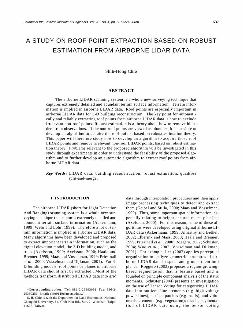
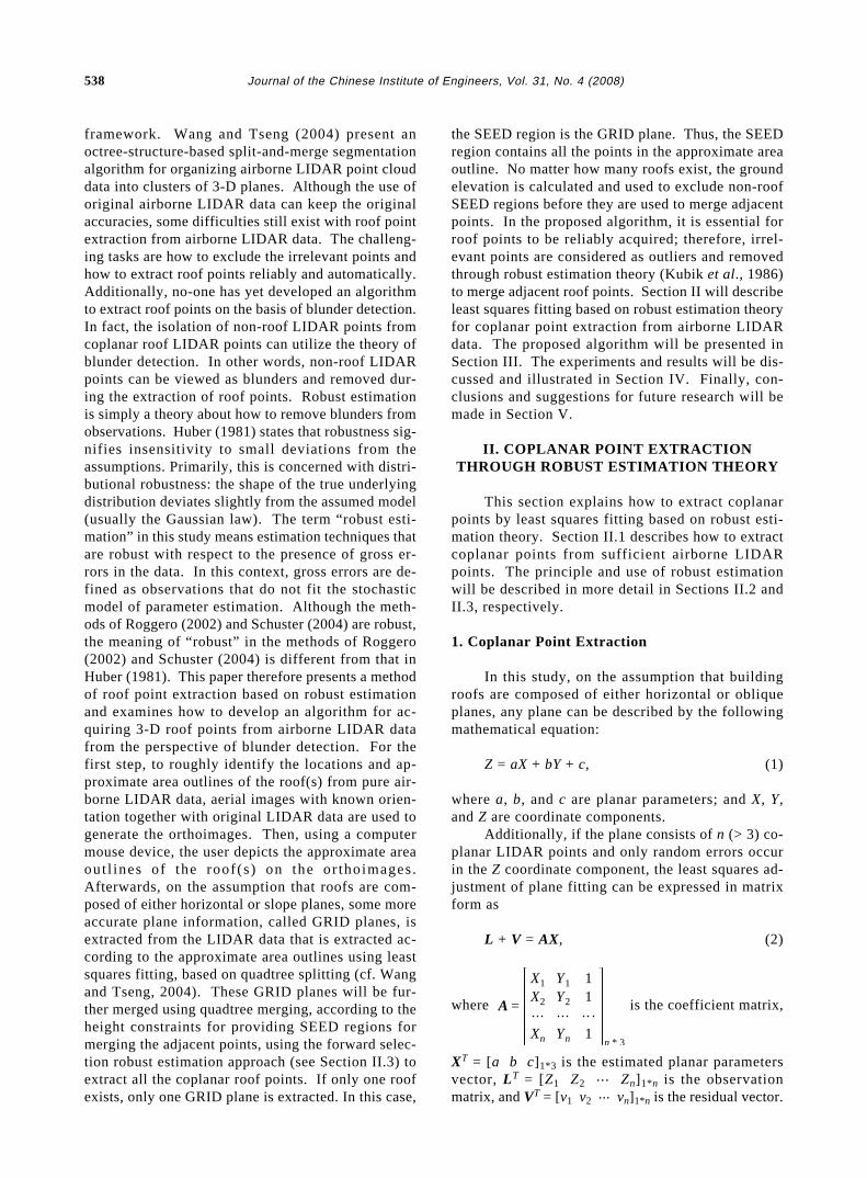
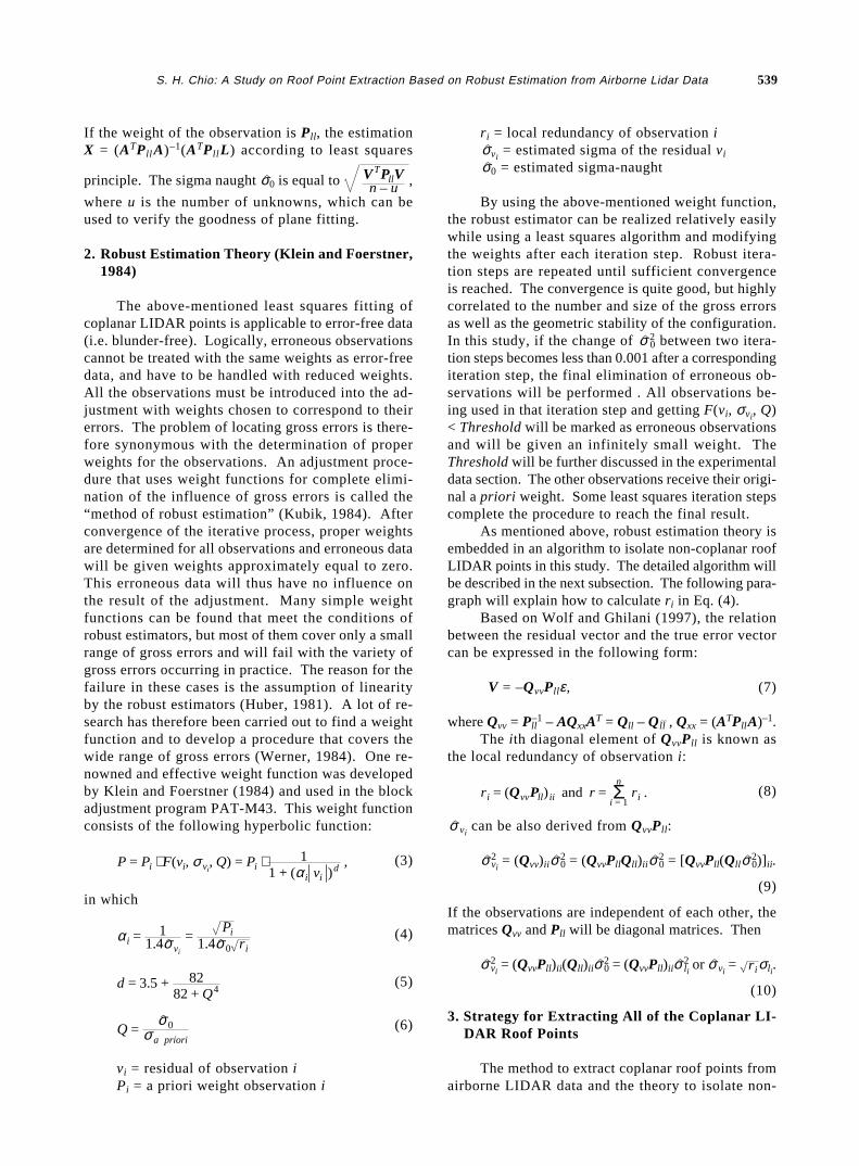
As mentioned in the previous paragraph, duringthe merging of adjacent roof LIDAR points, the partof all coplanar roof points on the same plane mustfirst be extracted. This task is done by using aquadtree split-and-merge segmentation algorithm (cf.Wang and Tseng, 2004). First, quadtree splittingbased on the least squares fitting principle is used tosplit the LIDAR data extracted according to the ap-proximate area outlines (black dash outlines shownin Fig. 1(a)) into GRID planes in which the sigma
naught is less than one threshold (e.g. 0.12 m), or thepoint number is less than one threshold, (e.g. 6). Fig.1(b) shows the extracted GRID planes. Secondly, theGRID planes are merged as SEED regions in termsof height constraints (i.e. quadtree merging).
During the process of merging the GRID planes,the GRID plane with the most points is selected asthe major GRID plane. The corresponding GRID centricheights can be calculated based on corresponding fit-ting plane parameters. Once a GRID plane adjacentto the major GRID plane is found, and if the differ-ence between these two centric heights is less thanone sigma naught of least squares fitting in the majorGRID plane, this adjacent GRID plane is immediatelymerged into the major GRID plane. Then anotheradjacent GRID plane is searched again based on theproximity of the merged GRID plane and the majorGRID plane. The same merging criterion is employedagain. This process of merging GRID planes is con-tinued until no more GRID planes can be merged. Afterthe first SEED region is acquired, the second majorGRID plane is selected again based on the point number.The merging process described above is carried outrepeatedly to find the second SEED region. This processis carried on until no more SEED regions can be found.Fig. 1(c) demonstrates the extracted SEED planes aftermerging the relevant GRID planes. If only one GRIDplane is found within the area outlines, the SEED re-gion will contain all the points in this outline.
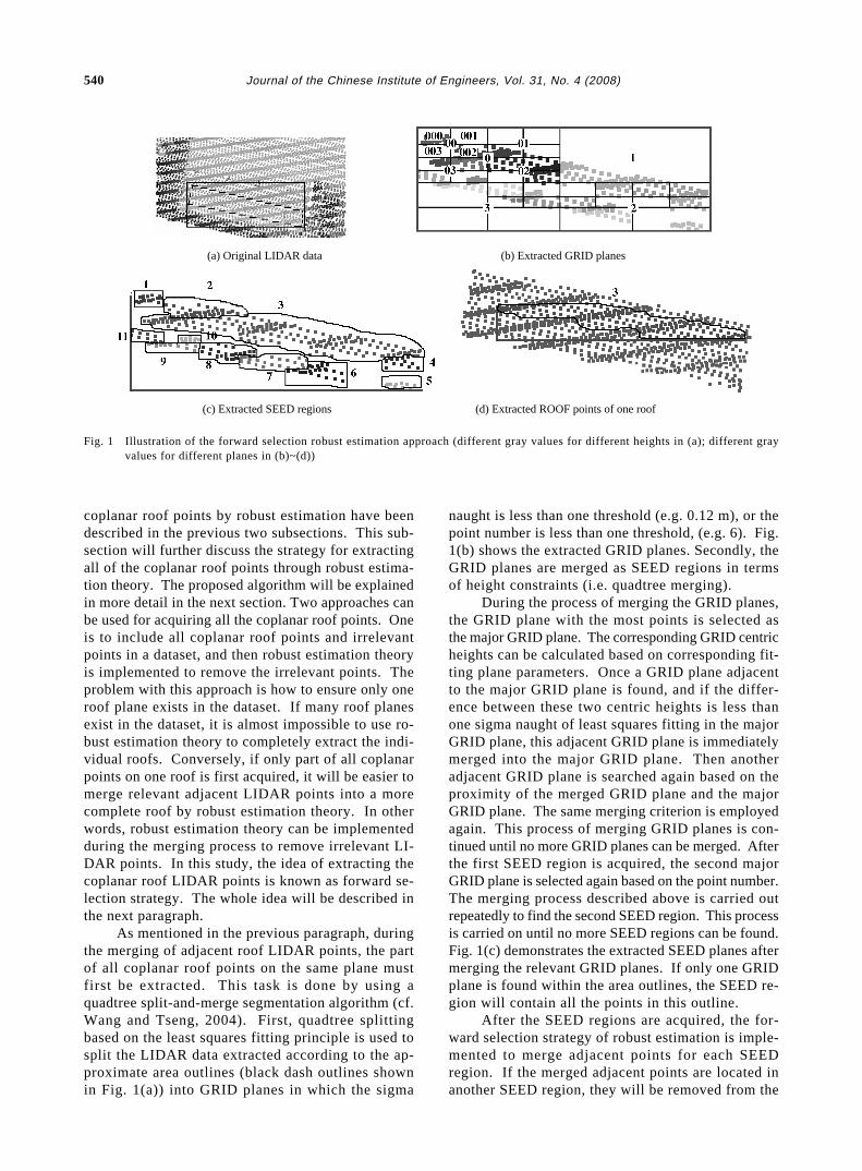
After the SEED regions are acquired, the for-ward selection strategy of robust estimation is imple-mented to merge adjacent points for each SEEDregion. If the merged adjacent points are located inanother SEED region, they will be removed from the
Fig. 1 Illustration of the forward selection robust estimation approach (different gray values for different heights in (a); different grayvalues for different planes in (b)~(d))
(a) Original LIDAR data
(c) Extracted SEED regions
(b) Extracted GRID planes
(d) Extracted ROOF points of one roof
S. H. Chio: A Study on Roof Point Extraction Based on Robust Estimation from Airborne Lidar Data 541
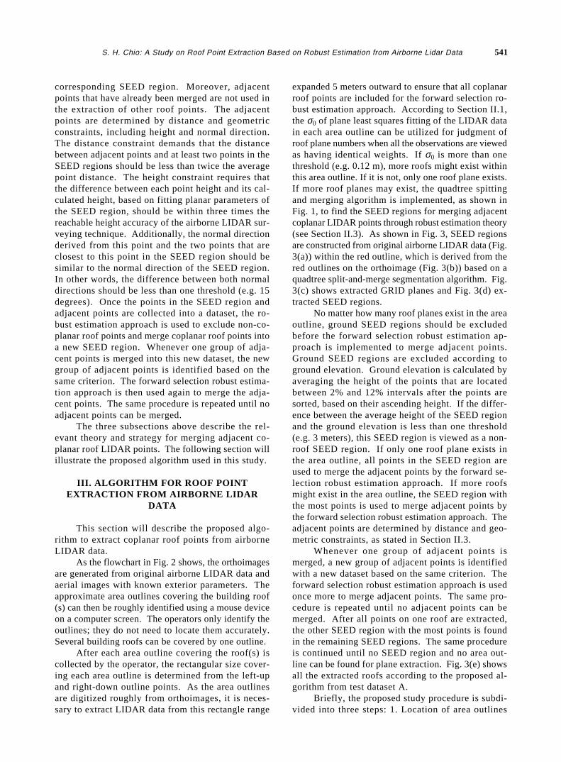
corresponding SEED region. Moreover, adjacentpoints that have already been merged are not used inthe extraction of other roof points. The adjacentpoints are determined by distance and geometricconstraints, including height and normal direction.The distance constraint demands that the distancebetween adjacent points and at least two points in theSEED regions should be less than twice the averagepoint distance. The height constraint requires thatthe difference between each point height and its cal-culated height, based on fitting planar parameters ofthe SEED region, should be within three times thereachable height accuracy of the airborne LIDAR sur-veying technique. Additionally, the normal directionderived from this point and the two points that areclosest to this point in the SEED region should besimilar to the normal direction of the SEED region.In other words, the difference between both normaldirections should be less than one threshold (e.g. 15degrees). Once the points in the SEED region andadjacent points are collected into a dataset, the ro-bust estimation approach is used to exclude non-co-planar roof points and merge coplanar roof points intoa new SEED region. Whenever one group of adja-cent points is merged into this new dataset, the newgroup of adjacent points is identified based on thesame criterion. The forward selection robust estima-tion approach is then used again to merge the adja-cent points. The same procedure is repeated until noadjacent points can be merged.
The three subsections above describe the rel-evant theory and strategy for merging adjacent co-planar roof LIDAR points. The following section willillustrate the proposed algorithm used in this study.
III. ALGORITHM FOR ROOF POINTEXTRACTION FROM AIRBORNE LIDAR
DATA
This section will describe the proposed algo-rithm to extract coplanar roof points from airborneLIDAR data.
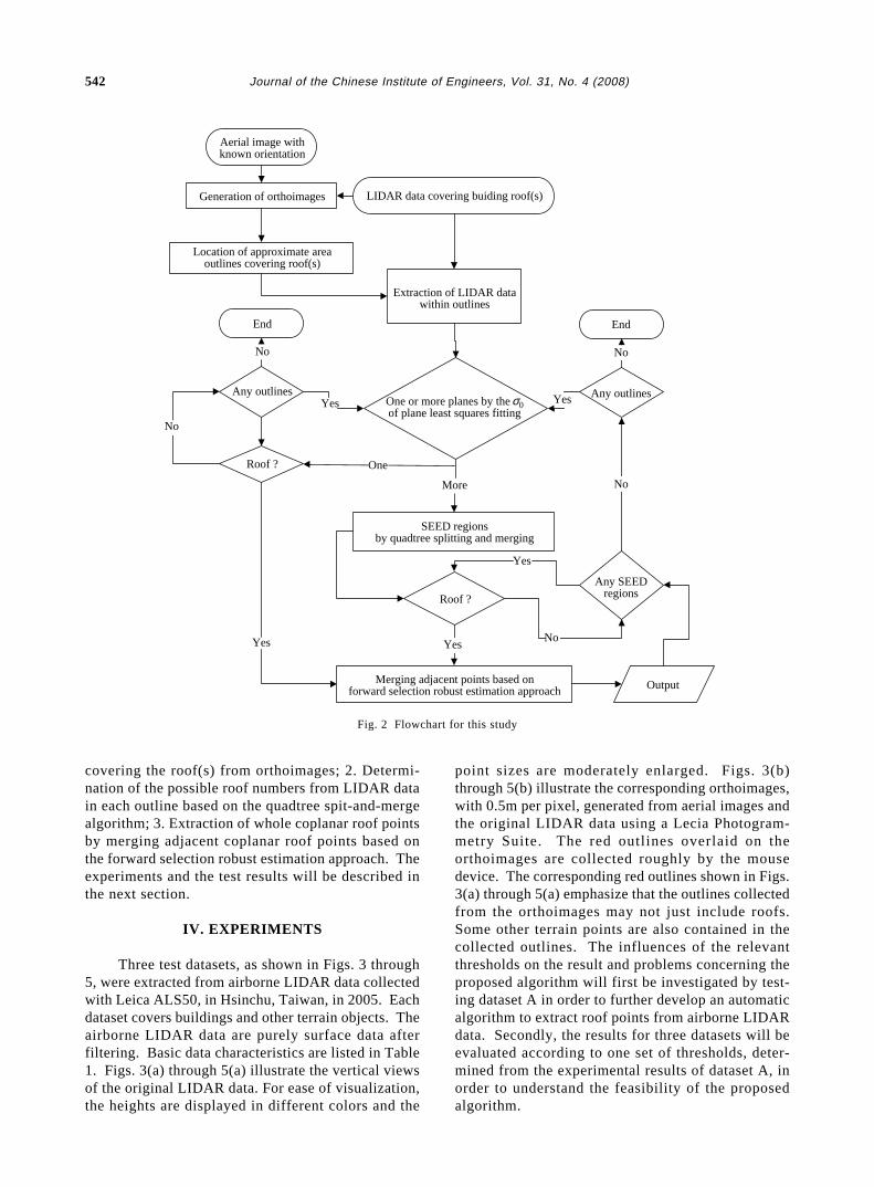
As the flowchart in Fig. 2 shows, the orthoimagesare generated from original airborne LIDAR data andaerial images with known exterior parameters. Theapproximate area outlines covering the building roof(s) can then be roughly identified using a mouse deviceon a computer screen. The operators only identify theoutlines; they do not need to locate them accurately.Several building roofs can be covered by one outline.
After each area outline covering the roof(s) iscollected by the operator, the rectangular size cover-ing each area outline is determined from the left-upand right-down outline points. As the area outlinesare digitized roughly from orthoimages, it is neces-sary to extract LIDAR data from this rectangle range
expanded 5 meters outward to ensure that all coplanarroof points are included for the forward selection ro-bust estimation approach. According to Section II.1,the σ0 of plane least squares fitting of the LIDAR datain each area outline can be utilized for judgment ofroof plane numbers when all the observations are viewedas having identical weights. If σ0 is more than onethreshold (e.g. 0.12 m), more roofs might exist withinthis area outline. If it is not, only one roof plane exists.If more roof planes may exist, the quadtree spittingand merging algorithm is implemented, as shown inFig. 1, to find the SEED regions for merging adjacentcoplanar LIDAR points through robust estimation theory(see Section II.3). As shown in Fig. 3, SEED regionsare constructed from original airborne LIDAR data (Fig.3(a)) within the red outline, which is derived from thered outlines on the orthoimage (Fig. 3(b)) based on aquadtree split-and-merge segmentation algorithm. Fig.3(c) shows extracted GRID planes and Fig. 3(d) ex-tracted SEED regions.
No matter how many roof planes exist in the areaoutline, ground SEED regions should be excludedbefore the forward selection robust estimation ap-proach is implemented to merge adjacent points.Ground SEED regions are excluded according toground elevation. Ground elevation is calculated byaveraging the height of the points that are locatedbetween 2% and 12% intervals after the points aresorted, based on their ascending height. If the differ-ence between the average height of the SEED regionand the ground elevation is less than one threshold(e.g. 3 meters), this SEED region is viewed as a non-roof SEED region. If only one roof plane exists inthe area outline, all points in the SEED region areused to merge the adjacent points by the forward se-lection robust estimation approach. If more roofsmight exist in the area outline, the SEED region withthe most points is used to merge adjacent points bythe forward selection robust estimation approach. Theadjacent points are determined by distance and geo-metric constraints, as stated in Section II.3.
Whenever one group of adjacent points ismerged, a new group of adjacent points is identifiedwith a new dataset based on the same criterion. Theforward selection robust estimation approach is usedonce more to merge adjacent points. The same pro-cedure is repeated until no adjacent points can bemerged. After all points on one roof are extracted,the other SEED region with the most points is foundin the remaining SEED regions. The same procedureis continued until no SEED region and no area out-line can be found for plane extraction. Fig. 3(e) showsall the extracted roofs according to the proposed al-gorithm from test dataset A.
Briefly, the proposed study procedure is subdi-vided into three steps: 1. Location of area outlines
542 Journal of the Chinese Institute of Engineers, Vol. 31, No. 4 (2008)
covering the roof(s) from orthoimages; 2. Determi-nation of the possible roof numbers from LIDAR datain each outline based on the quadtree spit-and-mergealgorithm; 3. Extraction of whole coplanar roof pointsby merging adjacent coplanar roof points based onthe forward selection robust estimation approach. Theexperiments and the test results will be described inthe next section.
IV. EXPERIMENTS
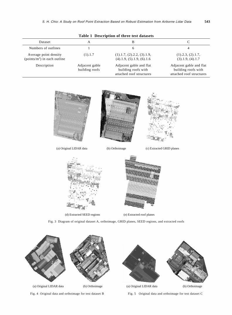
Three test datasets, as shown in Figs. 3 through5, were extracted from airborne LIDAR data collectedwith Leica ALS50, in Hsinchu, Taiwan, in 2005. Eachdataset covers buildings and other terrain objects. Theairborne LIDAR data are purely surface data afterfiltering. Basic data characteristics are listed in Table1. Figs. 3(a) through 5(a) illustrate the vertical viewsof the original LIDAR data. For ease of visualization,the heights are displayed in different colors and the
point sizes are moderately enlarged. Figs. 3(b)through 5(b) illustrate the corresponding orthoimages,with 0.5m per pixel, generated from aerial images andthe original LIDAR data using a Lecia Photogram-metry Suite. The red outlines overlaid on theorthoimages are collected roughly by the mousedevice. The corresponding red outlines shown in Figs.3(a) through 5(a) emphasize that the outlines collectedfrom the orthoimages may not just include roofs.Some other terrain points are also contained in thecollected outlines. The influences of the relevantthresholds on the result and problems concerning theproposed algorithm will first be investigated by test-ing dataset A in order to further develop an automaticalgorithm to extract roof points from airborne LIDARdata. Secondly, the results for three datasets will beevaluated according to one set of thresholds, deter-mined from the experimental results of dataset A, inorder to understand the feasibility of the proposedalgorithm.
Aerial image withknown orientation
Generation of orthoimages
Location of approximate areaoutlines covering roof(s)
End
Any outlines
Roof ?
Roof ?
No
No
One
More
Yes Yes
No
End
Any outlines
OutputMerging adjacent points based onforward selection robust estimation approach
SEED regionsby quadtree splitting and merging
One or more planes by the 0of plane least squares fitting
Extraction of LIDAR datawithin outlines
LIDAR data covering buiding roof(s)
Any SEEDregions
No
No
Yes
YesYes
σ
Fig. 2 Flowchart for this study
S. H. Chio: A Study on Roof Point Extraction Based on Robust Estimation from Airborne Lidar Data 543
(a) Original LIDAR data (b) Orthoimage
(d) Extracted SEED regions (e) Extracted roof planes
(c) Extracted GRID planes
Fig. 3 Diagram of original dataset A, orthoimage, GRID planes, SEED regions, and extracted roofs
(a) Original LIDAR data (b) Orthoimage
Fig. 4 Original data and orthoimage for test dataset B
(a) Original LIDAR data (b) Orthoimage
Fig. 5 Original data and orthoimage for test dataset C
Table 1 Description of three test datasets
Dataset A B C
Numbers of outlines 1 6 4
Average point density (1).1.7 (1).1.7, (2).2.2, (3).1.9, (1).2.3, (2).1.7,(points/m2) in each outline (4).1.9, (5).1.9, (6).1.6 (3).1.9, (4).1.7
Description Adjacent gable Adjacent gable and flat Adjacent gable and flatbuilding roofs building roofs with building roofs with
attached roof structures attached roof structures
544 Journal of the Chinese Institute of Engineers, Vol. 31, No. 4 (2008)
1. The Influences of Relevant Thresholds on theResult
This subsection investigates relevant thresholdsthat may affect the extraction results by using datasetA in order to get a better set of thresholds for auto-matic extraction of roof points. The first importantone is the threshold of the σ0 for plane least squaresfitting of the LIDAR data in each area outline for judg-ment of roof plane numbers. The threshold of the σ0
also affects the number of GRID patches. The thresh-old of point numbers for plane least squares fitting ineach GRID patch is also important, but it is fixed at 6in this study. The subsequent three thresholds are con-cerned with the judgment of the proximity when usingthe forward selection robust estimation approach tomerge the adjacent points. One threshold is the dis-tance constraint of adjacent points, one is the heightconstraint, and the other is the normal directionconstraint. Finally, the most important threshold forthe results is the weight threshold for F(vi, σvi
, Q), in-cluding a priori σ. This threshold will be used to high-light the erroneous observations.
(i) The Weight Thresholds for F(vi, σvi, Q)
Since the most important threshold for the re-sults is the weight threshold, this subsection will be-gin the investigation with this threshold. In order tounderstand how this threshold affects the extractedresults, some thresholds must be fixed during theinvestigation. According to Leica Geosystems (2006),the reachable height accuracy of airborne LIDAR sur-veying is 0.15 m. Therefore, the a priori σ in the weightthreshold for F(vi, σvi
, Q) is fixed at 0.15 m. Additionally,the threshold σ0 of plane least squares fitting for judg-ment of the number of roof planes and for extractingthe GRID patches is set at 0.12 m, which is better thanthe reachable height accuracy of LIDAR surveying.It is also reasonable to set the height constraint as 3
times 0.15 m, which is three times the reachable heightaccuracy of LIDAR surveying, for the judgment ofproximity when merging adjacent points. In addition,the threshold for the distance constraint of adjacentpoints is set as twice the average point distance andthe threshold for the normal direction constraint is nottaken into account at this stage of the current test.
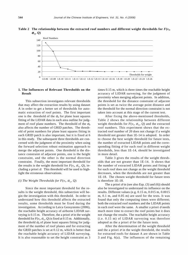
After fixing the above-mentioned thresholds,Table 2 shows the relationship between differentweight thresholds for F(vi, σvi
, Q) and the extractedroof numbers. This experiment shows that the ex-tracted roof number of 20 does not change if a weightthreshold not greater than 1E-14 is adopted. In orderto choose the best weight threshold for future tests,the number of extracted LIDAR points and the corre-sponding fitting σ for each roof in different weightthresholds, less than 1E-14, should be investigatedin more detail.
Table 3 gives the results of the weight thresh-olds that are not greater than 1E-14. It shows thatthe number of extracted LIDAR points and fitting σfor each roof does not change as the weight thresholddecreases, when the thresholds are not greater than1E-18. The chosen weight threshold for future testsis therefore 1E-18.
The a priori σ in (see also Eqs. (3) and (6)) shouldalso be investigated to understand its influence on theresults. Different values (e.g. 0.15 m, 0.015 m, 0.0015m, 0.1 m, and 0.05 m) are used for the tests. It wasfound that only the computing times were different;both the extracted roof numbers and the LIDAR pointsin each roof were the same. A smaller a priori σ needsmuch more time to extract the roof points but it doesnot change the results. The reachable height accuracy(i.e. 0.15 m) of LIDAR surveying was thereforeadopted as the a priori σ for the future tests.
After the determination of the weight thresholdand the a priori σ in the weight threshold, the resultsfor extracted roofs for dataset A are shown in Table3 and Fig. 6(a). The influences of the remaining
Table 2 The relationship between the extracted roof numbers and different weight thresholds for F(vi,σσσσσvi
, Q)
Thresholds for weight
Roof Numbers140
120
100
80
60
40
20
01.E-06 1.E-08 1.E-10 5.E-11 1.E-11 5.E-12 1.E-12 5.E-13 1.E-14 1.E-16 1.E-18 1.E-20 1.E-22 1.E-24 1.E-26
S. H. Chio: A Study on Roof Point Extraction Based on Robust Estimation from Airborne Lidar Data 545
thresholds on the results and the phenomena causedwill be described in the next subsection.
(ii) Some Phenomena in the Tests
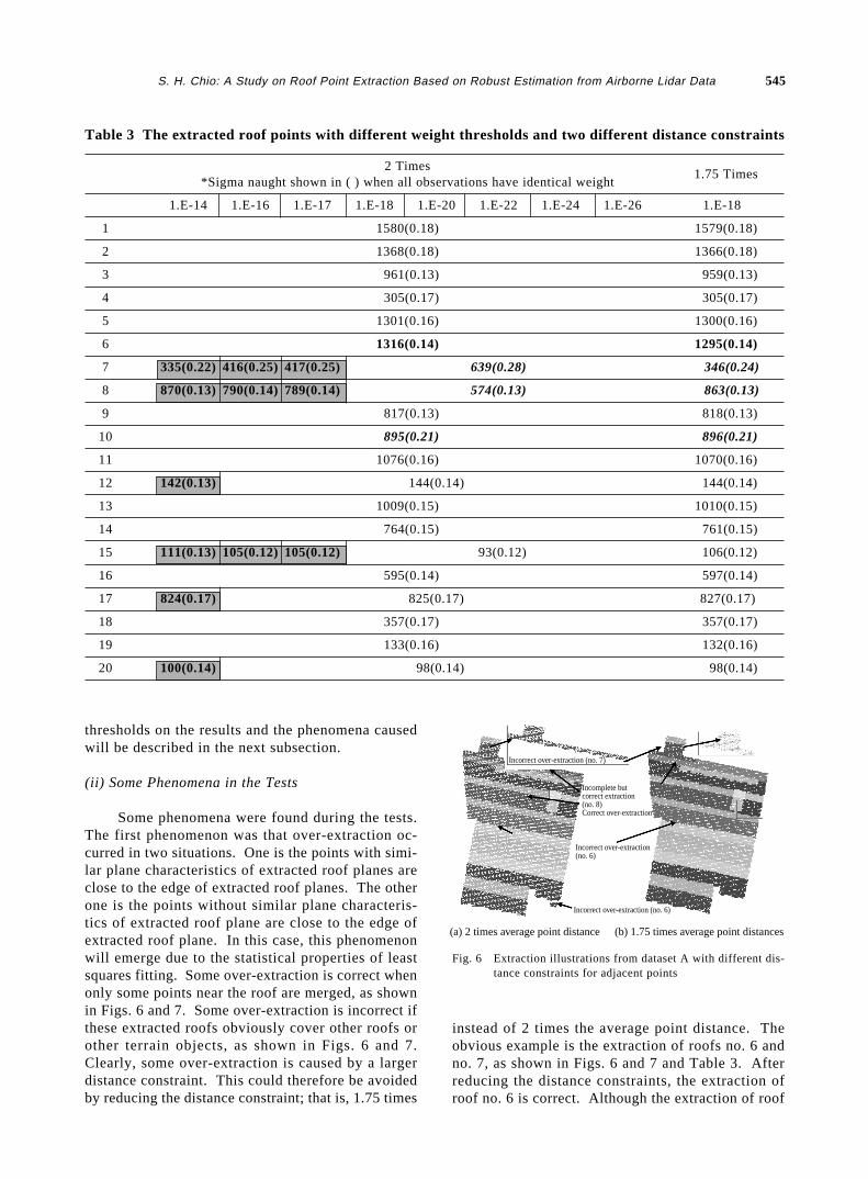
Some phenomena were found during the tests.The first phenomenon was that over-extraction oc-curred in two situations. One is the points with simi-lar plane characteristics of extracted roof planes areclose to the edge of extracted roof planes. The otherone is the points without similar plane characteris-tics of extracted roof plane are close to the edge ofextracted roof plane. In this case, this phenomenonwill emerge due to the statistical properties of leastsquares fitting. Some over-extraction is correct whenonly some points near the roof are merged, as shownin Figs. 6 and 7. Some over-extraction is incorrect ifthese extracted roofs obviously cover other roofs orother terrain objects, as shown in Figs. 6 and 7.Clearly, some over-extraction is caused by a largerdistance constraint. This could therefore be avoidedby reducing the distance constraint; that is, 1.75 times
instead of 2 times the average point distance. Theobvious example is the extraction of roofs no. 6 andno. 7, as shown in Figs. 6 and 7 and Table 3. Afterreducing the distance constraints, the extraction ofroof no. 6 is correct. Although the extraction of roof
Fig. 6 Extraction illustrations from dataset A with different dis-tance constraints for adjacent points
Table 3 The extracted roof points with different weight thresholds and two different distance constraints
2 Times1.75 Times
*Sigma naught shown in ( ) when all observations have identical weight
1.E-14 1.E-16 1.E-17 1.E-18 1.E-20 1.E-22 1.E-24 1.E-26 1.E-18
1 1580(0.18) 1579(0.18)
2 1368(0.18) 1366(0.18)
3 961(0.13) 959(0.13)
4 305(0.17) 305(0.17)
5 1301(0.16) 1300(0.16)
6 1316(0.14) 1295(0.14)
7 335(0.22) 416(0.25) 417(0.25) 639(0.28) 346(0.24)
8 870(0.13) 790(0.14) 789(0.14) 574(0.13) 863(0.13)
9 817(0.13) 818(0.13)
10 895(0.21) 896(0.21)
11 1076(0.16) 1070(0.16)
12 142(0.13) 144(0.14) 144(0.14)
13 1009(0.15) 1010(0.15)
14 764(0.15) 761(0.15)
15 111(0.13) 105(0.12) 105(0.12) 93(0.12) 106(0.12)
16 595(0.14) 597(0.14)
17 824(0.17) 825(0.17) 827(0.17)
18 357(0.17) 357(0.17)
19 133(0.16) 132(0.16)
20 100(0.14) 98(0.14) 98(0.14)
Incorrect over-extraction (no. 7)
Incomplete but correct extraction (no. 8)Correct over-extraction
Incorrect over-extraction(no. 6)
Incorrect over-extraction (no. 6)
(a) 2 times average point distance (b) 1.75 times average point distances
546 Journal of the Chinese Institute of Engineers, Vol. 31, No. 4 (2008)
no. 7 is still incorrect, the point numbers with incor-rect extraction are also reduced. However, it was alsofound that if the distance constraint is too small (e.g.1 times the average point distance), all the extractedroofs are incomplete. Conversely, over-extraction willbe obvious. The threshold for the distance constraintof adjacent points was therefore fixed at 1.75 timesthe average point distance for subsequent tests.
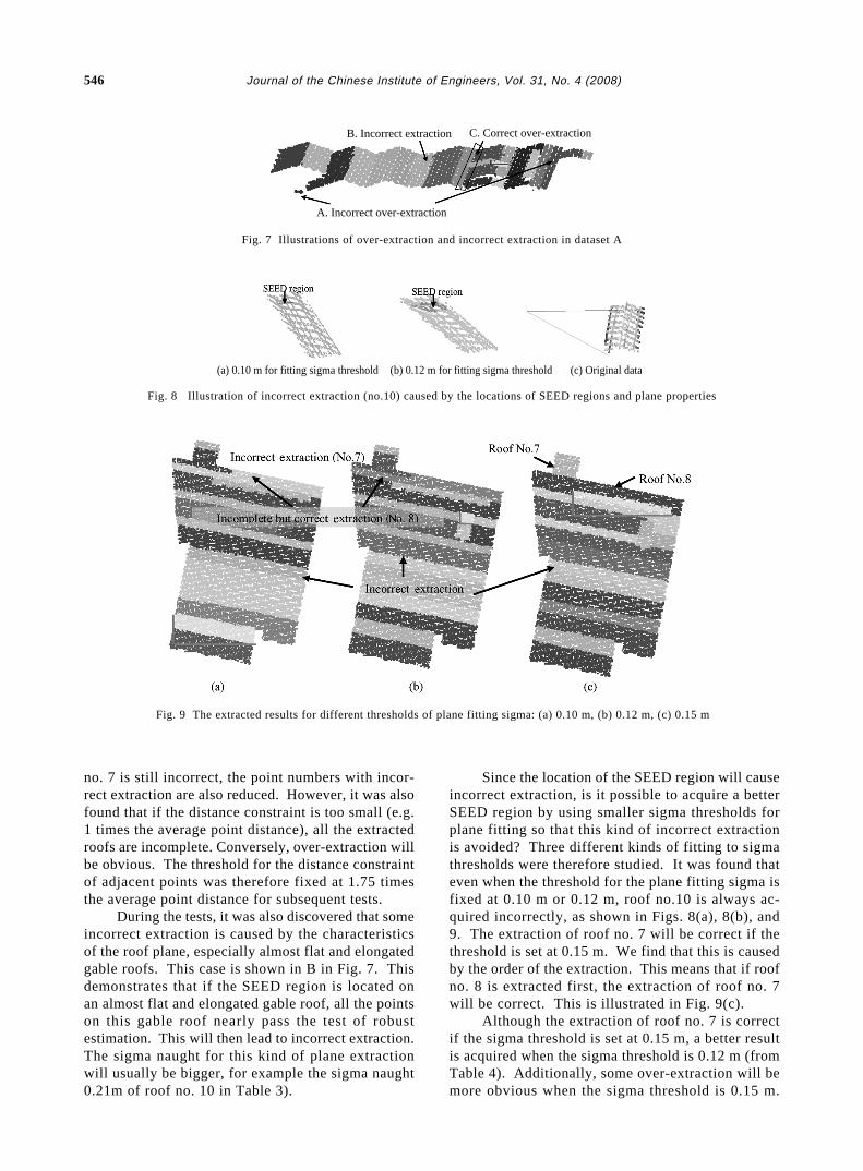
During the tests, it was also discovered that someincorrect extraction is caused by the characteristicsof the roof plane, especially almost flat and elongatedgable roofs. This case is shown in B in Fig. 7. Thisdemonstrates that if the SEED region is located onan almost flat and elongated gable roof, all the pointson this gable roof nearly pass the test of robustestimation. This will then lead to incorrect extraction.The sigma naught for this kind of plane extractionwill usually be bigger, for example the sigma naught0.21m of roof no. 10 in Table 3).
Since the location of the SEED region will causeincorrect extraction, is it possible to acquire a betterSEED region by using smaller sigma thresholds forplane fitting so that this kind of incorrect extractionis avoided? Three different kinds of fitting to sigmathresholds were therefore studied. It was found thateven when the threshold for the plane fitting sigma isfixed at 0.10 m or 0.12 m, roof no.10 is always ac-quired incorrectly, as shown in Figs. 8(a), 8(b), and9. The extraction of roof no. 7 will be correct if thethreshold is set at 0.15 m. We find that this is causedby the order of the extraction. This means that if roofno. 8 is extracted first, the extraction of roof no. 7will be correct. This is illustrated in Fig. 9(c).
Although the extraction of roof no. 7 is correctif the sigma threshold is set at 0.15 m, a better resultis acquired when the sigma threshold is 0.12 m (fromTable 4). Additionally, some over-extraction will bemore obvious when the sigma threshold is 0.15 m.
A. Incorrect over-extraction
B. Incorrect extraction C. Correct over-extraction
Fig. 7 Illustrations of over-extraction and incorrect extraction in dataset A
Fig. 8 Illustration of incorrect extraction (no.10) caused by the locations of SEED regions and plane properties
(a) 0.10 m for fitting sigma threshold (b) 0.12 m for fitting sigma threshold (c) Original data
Fig. 9 The extracted results for different thresholds of plane fitting sigma: (a) 0.10 m, (b) 0.12 m, (c) 0.15 m
S. H. Chio: A Study on Roof Point Extraction Based on Robust Estimation from Airborne Lidar Data 547
Therefore, 0.12 m will be used as the threshold ofplane fitting sigma.
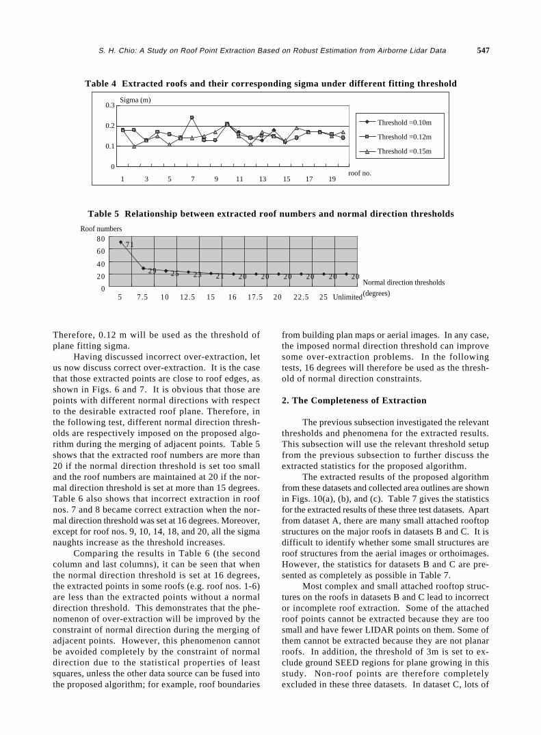
Having discussed incorrect over-extraction, letus now discuss correct over-extraction. It is the casethat those extracted points are close to roof edges, asshown in Figs. 6 and 7. It is obvious that those arepoints with different normal directions with respectto the desirable extracted roof plane. Therefore, inthe following test, different normal direction thresh-olds are respectively imposed on the proposed algo-rithm during the merging of adjacent points. Table 5shows that the extracted roof numbers are more than20 if the normal direction threshold is set too smalland the roof numbers are maintained at 20 if the nor-mal direction threshold is set at more than 15 degrees.Table 6 also shows that incorrect extraction in roofnos. 7 and 8 became correct extraction when the nor-mal direction threshold was set at 16 degrees. Moreover,except for roof nos. 9, 10, 14, 18, and 20, all the sigmanaughts increase as the threshold increases.
Comparing the results in Table 6 (the secondcolumn and last columns), it can be seen that whenthe normal direction threshold is set at 16 degrees,the extracted points in some roofs (e.g. roof nos. 1-6)are less than the extracted points without a normaldirection threshold. This demonstrates that the phe-nomenon of over-extraction will be improved by theconstraint of normal direction during the merging ofadjacent points. However, this phenomenon cannotbe avoided completely by the constraint of normaldirection due to the statistical properties of leastsquares, unless the other data source can be fused intothe proposed algorithm; for example, roof boundaries
from building plan maps or aerial images. In any case,the imposed normal direction threshold can improvesome over-extraction problems. In the followingtests, 16 degrees will therefore be used as the thresh-old of normal direction constraints.
2. The Completeness of Extraction
The previous subsection investigated the relevantthresholds and phenomena for the extracted results.This subsection will use the relevant threshold setupfrom the previous subsection to further discuss theextracted statistics for the proposed algorithm.
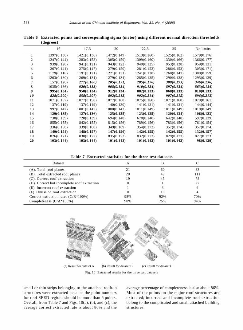
The extracted results of the proposed algorithmfrom these datasets and collected area outlines are shownin Figs. 10(a), (b), and (c). Table 7 gives the statisticsfor the extracted results of these three test datasets. Apartfrom dataset A, there are many small attached rooftopstructures on the major roofs in datasets B and C. It isdifficult to identify whether some small structures areroof structures from the aerial images or orthoimages.However, the statistics for datasets B and C are pre-sented as completely as possible in Table 7.
Most complex and small attached rooftop struc-tures on the roofs in datasets B and C lead to incorrector incomplete roof extraction. Some of the attachedroof points cannot be extracted because they are toosmall and have fewer LIDAR points on them. Some ofthem cannot be extracted because they are not planarroofs. In addition, the threshold of 3m is set to ex-clude ground SEED regions for plane growing in thisstudy. Non-roof points are therefore completelyexcluded in these three datasets. In dataset C, lots of
Table 4 Extracted roofs and their corresponding sigma under different fitting threshold
Threshold =0.10m
Threshold =0.12m
Threshold =0.15m
0.3
0.2
0.1
0
1
Sigma (m)
3 5 7 9 11 13 15 17 19roof no.
Table 5 Relationship between extracted roof numbers and normal direction thresholds
71
29 25 23 21 20 20 20 20 20 20
0
20
40
60
80
5 7.5 10 12.5 15 16 17.5 20 22.5 25 Unlimited
Normal direction thresholds (degrees)
Roof numbers
548 Journal of the Chinese Institute of Engineers, Vol. 31, No. 4 (2008)
Table 7 Extracted statistics for the three test datasets
Dataset A B C
(A). Total roof planes 21 60 83(B). Total extracted roof planes 20 49 111(C). Correct roof extraction 19 45 78(D). Correct but incomplete roof extraction 0 1 27(E). Incorrect roof extraction 1 3 6(F). Omission roof extraction 0 10 4Correct extraction rates (C/B*100%) 95% 92% 70%Completeness (C/A*100%) 90% 75% 94%
Fig. 10 Extracted results for the three test datasets
Table 6 Extracted points and corresponding sigma (meter) using different normal direction thresholds(degrees)
16 17.5 20 22.5 25 No limits
1 1397(0.130) 1421(0.136) 1472(0.149) 1513(0.160) 1525(0.162) 1579(0.176)2 1247(0.144) 1283(0.153) 1305(0.159) 1309(0.160) 1330(0.166) 1366(0.177)3 939(0.120) 941(0.121) 943(0.122) 949(0.125) 953(0.128) 959(0.131)4 267(0.141) 275(0.147) 279(0.150) 281(0.152) 286(0.153) 305(0.171)5 1179(0.118) 1191(0.121) 1221(0.131) 1241(0.138) 1260(0.143) 1300(0.159)6 1263(0.130) 1269(0.131) 1279(0.134) 1285(0.135) 1290(0.138) 1295(0.139)7 157(0.126) 277(0.160) 285(0.171) 285(0.176) 300(0.193) 346(0.236)8 1035(0.136) 920(0.133) 908(0.134) 910(0.134) 897(0.134) 863(0.134)9 995(0.134) 958(0.134) 912(0.134) 882(0.133) 868(0.133) 818(0.133)
10 828(0.200) 858(0.207) 892(0.213) 902(0.214) 907(0.215) 896(0.213)11 1071(0.157) 1077(0.158) 1077(0.160) 1075(0.160) 1071(0.160) 1070(0.161)12 137(0.119) 137(0.119) 140(0.130) 141(0.131) 141(0.131) 144(0.144)13 997(0.142) 1001(0.143) 1000(0.143) 1011(0.149) 1011(0.149) 1010(0.149)14 129(0.135) 127(0.136) 125(0.135) 123(0.135) 120(0.134) 106(0.123)15 738(0.139) 720(0.139) 694(0.140) 678(0.140) 642(0.140) 597(0.139)16 855(0.155) 842(0.155) 815(0.156) 789(0.156) 783(0.156) 761(0.154)17 336(0.158) 339(0.160) 349(0.169) 354(0.172) 357(0.174) 357(0.174)18 149(0.154) 148(0.157) 147(0.156) 142(0.155) 142(0.155) 132(0.157)19 826(0.171) 830(0.172) 835(0.173) 832(0.173) 829(0.173) 827(0.173)20 103(0.144) 103(0.144) 101(0.143) 101(0.143) 101(0.143) 98(0.139)
(a) Result for dataset A (b) Result for dataset B (c) Result for dataset C
small or thin strips belonging to the attached rooftopstructures were extracted because the point numbersfor roof SEED regions should be more than 6 points.Overall, from Table 7 and Figs. 10(a), (b), and (c), theaverage correct extracted rate is about 86% and the
average percentage of completeness is also about 86%.Most of the points on the major roof structures areextracted; incorrect and incomplete roof extractionbelong to the complicated and small attached buildingstructures.
S. H. Chio: A Study on Roof Point Extraction Based on Robust Estimation from Airborne Lidar Data 549
V. CONCLUSIONS AND SUGGESTIONS FORFUTURE RESEARCH
The airborne LIDAR scanning system is a wholenew surveying technique that captures extremely de-tailed and abundant terrain surface information. Ter-rain information is implied in airborne LIDAR data.The roof points in airborne LIDAR data are especiallyimportant for 3-D building reconstruction. The ex-traction of building roof points from airborne LIDARdata is therefore an important task for 3-D buildingreconstruction. The most difficult part of roof pointextraction from airborne LIDAR data lies in how toexclude the irrelevant data and how to extract the re-quired data both reliably and completely. This paperproposed an algorithm to acquire roof LIDAR pointsand remove irrelevant non-roof LIDAR points basedon robust estimation theory. From the experiments,the relevant problems concerning the proposed algo-rithm have been investigated and one set of thresh-olds has been used to extract roof points from airborneLIDAR data automatically. Both the average correctextracted rate and the average percentage of complete-ness are about 86% in the proposed algorithm. Inaddition, almost all of the major roof structures wereextracted by the proposed algorithm in the three testdatasets. The experiments have proved the feasibilityof the proposed algorithm, and the possibility of auto-matically extracting roof points from airborne LIDARdata has also been raised. The proposed methodologydoes remove the relevant data from desirable roof planesfrom the experiments. However, the approximate out-lines covering roofs were collected manually in thisstudy. Future work could therefore acquire these areaoutlines automatically from another data source or fromLIDAR data itself using image processing techniques.These experimental results also show that other datashould be integrated for a more accurate extraction ofroof points. Subsequent studies should therefore beconducted by integrating different data sources (e.g.aerial images), based on current results, for a muchmore complete reconstruction of building models.
ACKNOWLEDGEMENT
The author would like to acknowledge threeanonymous referees for thoughtful comments andsuggestions. However, the author will be responsiblefor any omissions or errors about this paper. Also,the author would like to thank Ministry of the Interior,Taiwan, R.O.C. for providing the test LIDARdatasets.
NONMENCLATURE
A the coefficient matrix
F(vi, σvi, Q) the correct factor for the weight of ob-
servation iL the observation matrixn the number of observationsPi a priori weight of the observation iPll the weight matrix of the observationsQll the co-factor matrix of observationsQ^
l^
l the co-factor matrix of observations af-ter adjustment
Qvv the co-factor matrix of residualsri the local redundancy of observation iX the estimated parameters vectoru the number of unknownsV the residual vectorvi the residual of observation i, meter in
SI unitZ = aX + bY + c planar equation, where a, b, and
c are planar parameters; and X, Y, and Zare coordinate components, meter in SIunit
σ0 the priori sigma-naught, meters in SIunit
^σ0 the estimated sigma-naught, meter in SIunit
σa priori the priori sigma-naught, meter in SI unit ^σvi
the estimated sigma of the residual vi,meter in SI unit
REFERENCES
Ackermann, F., 1999, “Airborne Laser Scanning -Present Status and Future Expectations,” ISPRSJournal of Photogrammetry & Remote Sensing,Vol. 54, No. 2, pp. 64-67.
Alharthy, A., and Bethel, J., 2002, “Heuristic Filteringand 3D Feature Extraction from LIDAR data,” In-ternational Archives of Photogrammetry and Re-mote Sensing, Vol. 33, Part A, pp. 29-34.
Axelsson, P., 1999, “Processing of Laser ScannerData - Algorithms and Applications,” ISPRS Jour-nal of Photogrammetry & Remote Sensing, Vol.54, No. 2, pp. 138-147.
Axelsson, P., 2000, “DEM Generation from LaserScanner Data Using Adaptive TIN Models,” In-ternational Archives of Photogrammetry and Re-mote Sensing, Vol. 33, Part B4/1, pp. 110-117.
Elberink, S. O., and Maas, H., 2000, “The Use ofAnisotropic Height Texture Measure for TheSegmentation of Airborne Laser Scanner Data,”International Archives of Photogrammetry andRemote Sensing, Vol. 33, part B3/2, pp. 678-684.
Geibel, R., and Stilla, U., 2000, “Segmentation of LaserAltimeter Data for Building Reconstruction: Dif-ferent Procedures and Comparison,” InternationalArchives of Photogrammetry and Remote Sensing,Vol. 33, Part B3, pp. 326-334.
550 Journal of the Chinese Institute of Engineers, Vol. 31, No. 4 (2008)
Huber, P.J., 1981, Robust Statistics, John Wiley &Sons, Inc., NY, USA, pp. 1.
Haala, N. and Brenner, C., 1999, “Extraction of Build-ing and Trees in Urban Environments,” ISPRSJournal of Photogrammetry & Remote Sensing,Vol. 54, No. 2, pp. 130-137.
Klein, H., and Foerstner, W., 1984, “Realization ofAutomatic Error Detection in the Block Adjust-m e n t P r o g r a m P A T - M 4 3 U s i n g R o b u s tEstimators,” International Archives of Photo-grammetry and Remote Sensing, Vol. 25, Part 3A,pp. 234-245.
Kubik, K., D. Merchant, and T. Schenk, 1986,“Grosserrors and robust estimation,” TechnicalPapers, 1986 ACSM-ASPRS Annual Convention,Washington D.C., USA, Vol. 4, pp. 250-255.
Lee, I., 2002, “Perceptual Organization of Surfaces,”PhD. Dissertation, Graduate Program in Geo-detic Science and Surveying, The Ohio StateUniversity, Columbus, OH, USA.
Leica Geosystems, 2006, ALS50 Airborne LaserScanner Introduction, Available :http://gis.leica-geosystems.com/, Leica Geosystems, GA, USA(last date accessed 1, March, 2006).
Maas, H. G., and Vosselman, G., 1999, “Two Algo-rithms for Extracting Building Models from RawLaser Altimetry Data,” ISPRS Journal of Photo-grammetry & Remote Sensing, Vol. 54, No. 2, pp.153-163.
Priestnall, G., Jaafar, J., and Duncan, A., 2000,“Extracting Urban Feature from LiDAR DigitalSurface Models,” Computers, Environment andUrban Systems, Vol. 24, No. 2, pp. 65-78.
Roggero, M., 2002, “Object Segmentation with RegionGrowing and Principal Component Analysis,” In-ternational Archives of Photogrammetry, RemoteSensing and Spatial Information Sciences, Vol. 34
Part 3A, pp. 289-294.Schuster, H. F., 2004, “Segmentation of Lidar Data
Using the Tensor Voting Framework,” Interna-tional Archives of Photogrammetry, Remote Sens-ing and Spatial Information Sciences, Vol. 35,Part B3, pp. 1073-1078.
Wang, M., and Tseng, Y-H., 2004, “LIDAR DataSegmentation and Classification Based on OctreeStructure,” International Archives of Photo-grammetry, Remote Sensing and Spatial Informa-tion Sciences, Vol. 35, Part B3, pp. 1682-1750.
Wehr, A., and Lohr, U., 1999, “Airborne Laser Scan-ning-An Introduction and Overview,” ISPRSJournal of Photogrammetry & Remote Sensing,Vol. 54, No. 2, pp. 68-92.
Werner, H. 1984, “Automatic Gross Error Detectionby Robust Estimators,” International Archives ofPhotogrammetry and Remote Sensing, Vol. 25,Part 3, pp. 197-219.
Wolf, Paul R., and Ghilani, Charles D., 1997, Adjust-ment Computations: Statistics and Least Squaresin Surveying and GIS, John Wiley & Sons, Inc.,NY, USA, pp. 402-406.
Woo, H., Kang, E., Wang, S., and Lee, K. H., 2002,“A New Segmentation Method for Point CloudData,” International Journal of Machine Tools &Manufacture, Vol. 42, No. 2, pp. 167-178.
Vosselman, G.. and Dijkman, S., 2001, “3D BuildingModel Reconstruction from Point Clouds andGround Plans,” International Archives of Photo-grammetry and Remote Sensing, Vol. 34, Part 3/W4, pp. 37- 44.
Manuscript Received: Jan. 18, 2007Revision Received: Jan. 22, 2008
and Accepted: Feb. 22, 2008