a study of subsurface water flow in a …
TRANSCRIPT

A STUDY OF SUBSURFACE WATER FLOW
IN A SOUTHEASTERN MINNESOTA KARST
DRAINAGE BASIN
A THESIS
SUBMITTED TO THE FACULTY OF THE GRADUATE SCHOOL
OF THE UNIVERSITY OF MINNESOTA
BY
ERIC HERBERT MOHRING
IN PARTIAL FULFILLMENT OF THE REQUIREMENTS
FOR THE DEGREE OF
MASTER OF SCIENCE
AUGUST 1983

By June our brook's run out of song and speed. Sought for much after that, it will be found Either to have gone groping underground Or flourished and come up in jewel-weed, Weak foliage that is blown upon and bent Even against the way its waters went. Its bed is left a faded paper sheet Of dead leaves stuck together by the heatA brook to none but who remember long. This as it will be seen is other far Than with brooks taken otherwhere in song. We love the things we love for what they are.
- Robert Frost

ABSTRACT
The Root River drainage basin in Fillmore county, southeastern
Minnesota has well developed karst topography and karst groundwater flow
in carbonate sedimentary rocks of upper Ordovician age. In the upper
carbonate aquifer subsurface water flows rapidly through solution
enlarged fractures and conduits, and is intimately connected to surface
water. As such it is very susceptible to pollution.
An area was chosen in the drainage of the South Branch of the Root
River, southeast of the town of Spring Valley, for detailed hydrologic
study. The area has one of the highest densities of karst features in
Minnesota.
The first part of the study involved quantitative fluorometric
tracing of subsurface water using the fluorescent dye Rhodamine WT and a
field fluorometer. The tracing studies delineated subsurface flowpaths,
revealed travel times and dispersion along the flowpaths, and permitted
mass balance calculations of inflowing and outflowing water. The traces
defined the recharge area of Moth and Grabau Springs at the head of
Forestville Creek, an important trout stream.
A gauging station was installed to measure the discharge of these
springs, and so far has produced two years of continuous record. A net
work of rain gauges was installed to measure precipitation over the
recharge area. Data from these installations describe the way the karst
system responds to recharge events. Several sub-environments of flow
exist within the aquifer. Initial estimates of transmissi vi ty and
aquifer diffusivity can be derived from the data.
-i-

ACKNOWLEDGMENTS
This research was supported by grants from the Legislative
Commission on Minnesota Resources to the Minnesota Geological Survey.
Financial support was also provided by a University of Minnesota
Institute of Technology Corporate Associate Fellowship, and by a Lando
Fellowship.
First of all I would like to thank Calvin Alexander for his
unceasing support and guidance over the last few years, and for many
productive and lively discussions during all phases of this project.
This study would not have been possible without the previous mapping and
subsurface water tracing work of Ron Spong, Ramesh Venkatakrishnan, and
many others. I am grateful to all those who assisted me in the field in
various ways, including Bridget O'Brien, Warren Beck, Paul Book, Phil
Hewitt, Dave Rogers, Stephen Mohring, Mike Mccrum, Kate Mader, Shiela
Grow, and Barb Silverman. I wish to thank the United States Geological
Survey Water Resources Division in St. Paul, and especially Jerry Hicks,
for loaning a water level recorder and assisting in the construction of
the gauging station.
I would like to thank the residents of Fillmore county who helped in
this project. Thanks to Niel Davie for giving me access to Mystery
Cave. Thanks to Mike Hellerud for operating the recording rain gauge,
and to other residents around Spring Valley for faithfully keeping daily
precipitation records. Thanks to Ken Hadland for lodging and for the
use of his house as a field base station. Finally, special thanks to
the Root family for letting me tromp on their land at all hours of the
day and night, for permitting me to construct the gauging station on
-ii-

their land, and for all-around hospitality.
-iii-

TABLE OF CONTENTS
Page
ABSTRACT •••••••••••••••••••••••••••••••••••••••••••••••••••••••••• i
ACKOWLEDGMENTS •••••••••••••••••••••••••••••••••••••••••••••••••••• ii
TABLE OF CONTENTS •••••••••.••••••••••.•••.••...••.....•••....•••.. iv
LIST OF FIGURES ..•••....••.•.•...•.•..•.•••.••••••.••••.•..••..••• vii
I • INTRODUCTION ••••••••••••••••••••••••••••••••••••••••••••••••• 1
II. GEOLOGICAL SETTING AND DESCRIPTION OF STUDY AREA ••••••••••••• 6
Geology . .....•••.....•........•.•...•......•.....••..••... 6
Physiography . ...••.•....•••.........•..•....•............. 9
Karst Development ••••••••••••••••••••••••••••••••••••••••• g
Description of Karst Features in the Study Area ••••••••••• 11
South Branch of the Root River ••••••••••••••••••••••••• 13
Mystery Cave ••••••••••••••••••••••••••••••••••••••••••• 13
Seven Springs ••.•••.••••••••.•....•••••.••••••••••••••. 13
Moth and Grabau Springs •••••••••••••••••••••••••••••••• 16
Fairview Blind Valley •••••••••••••••••••••••••••••••••• 16
Other Karst Features ••••••••••••••••••••••••••••••••••• 19
III. QUANTITATIVE FLUOROMETRIC DYE TRACING •••••••••••••••••••••••• 21
Methods • •••••••••••••••••••••••••••••••••••••••••••••••••• 22
Data Analysis •.•••.••.•••..••••....••.•••••••••••..••••.•. 23
Results . . . . . . . . . . . . . . . . . . . . . . . . . . . . . . . . . . . . . . . . . . . . . . . . . . . 24
Disappearing River to Seven Springs, Oct. 10, 1979 ••••• 24
Disappearing River to Seven Springs, Sept. 2, 1980 ••••• 26
Formation Route Creek to Seven Springs ••••••••••••••••• 28
-iv-

Matheson Sink to Seven, Moth, and Grabau Springs ••••••• 28
Fairview Blind Valley to Moth and Grabau Springs ••••••• 32
High Flow • ........................................... 32
Low Flow ••.• •.•••.•••.•••...••••.•••.••••.•..••••••. 32
Natural Well to Moth and Grabau Springs •••••••••••••••• 35
Red Tail Sink to Moth and Grabau Springs ••••••••••••••• 38
Lefevre Blind Valley to Moth and Grabau Springs •••••••• 38
Root River Dye Traces •••••••••••••••••••••••••••••••••• 38
August 1981 Root River Dye Trace ••••••••••••••••••••••• 41
August 1982 Root River Dye Trace ••••••••••••••••••••••• 43
Inter-Basin Connection ••••••••••••••••••••••••••••••••• 47
Summary and Conclusions •.••••••••••.••••••••.•••.••••••.•• 50
IV. STUDY OF MOTH AND GRABAU SPRINGS DRAINAGE BASIN •••••••••••••• 54
Gauging Station •••••.••••••.•.•••.•.••••••...•••••••••.••• 54
Construction ••••..••••••••••••••.•.•••••••••..••••••••• 54
Calibration •••••••••••••••••••••••••••••••••••••••••••• 55
Rain Gauge Network ••••••••••••.••••.•••••••..••••••.••...• 58
Expected Results •••••••••••••••••••••••••••••••••••••••••• 58
Results . .................................................. 60
Storm Responses ••••..••••..••••••...•••.•.••••.••••••.• 62
Recession Curve Analysis ••••••••••••••••••••••••••••••• 68
Summary and Conclusions ••••••••••••••••••••••••••••••••••• 79
V. CONCLUSIONS • ...•.•••.•.•••••.•••..••••••.••.•••.••••••..••..• 81
REFERENCES •• •••••••••••••••••••••••••••••••••••••••••••••••••••••• 83
APPENDIX A • ••••••••••••••••••••••••••••••••••••••••••••••••••••••• 87
-v-

APPENDIX B •••••••••••••••••••••••••••••••••••••••••••••••••••••••• 97
APPENDIX C •••••••••••••••••••••••••••••••••••••••••••••••••••••••• 9 9
-vi-

LIST OF FIGURES
Figure Page
1. Location of the study area ••••••••••••••••••••••••••••••••••• 3
2. Two ways of investigating a karst aquifer •••••••••••••••••••• 5
3. Generalized stratigraphic column ••••••••••••••••••••••••••••• 7
4. Geologic map of the study area ••••••••••••••••••••••••••••••• 8
5. Karst features and dye trace connections in the study area ••• 12
6. Location of Mystery Cave ••••••••••••••••••••••••••••••••••••• 14
7. Map of Seven Springs and area •••••••••••••••••••••••••••••••• 15
8. Map of Moth and Grabau Springs ••••••••••••••••••••••••••••••• 17
9. Map of Fairview Blind Valley ••••••••••••••••••••••••••••••••• 18
10. Map and cross section of Natural Well •••••••••••••••••••••••• 20
11. Dye trace from Disappearing River to Seven Springs,
Oct. 10, 1979••••••••••••••••••••••••••••••••••••••••••••••25
12. Dye trace from Disappearing River to Seven Springs,
Sept. 2, 1980 •••••••••••••••••••••••••••••••••••••••••••••• 27
13. Dye trace from Formation Route Creek to Seven Springs •••••••• 29
14. Dye trace from Matheson Sink to Seven Springs, Moth
Spring, and Grabau Spring •••••••••••••••••••••••••••••••••• 30
15. Dye trace from Fairview Blind Valley (Hellerud Sink A)
to Moth and Grabau Springs ••••••••••••••••••••••••••••••••• 33
16. Dye trace from Fairview Blind Valley (Poldervaard Sink A)
to Moth and Grabau Springs ••••••••••••••••••••••••••••••••• 34
17. Schematic cross section of the subsurface flowpath between
Fairview Blind Valley and Moth and Grabau Springs •••••••••• 36
-vii-

18. Dye trace from Natural Well to Moth and Grabau Springs ••••••• 37
19. Dye trace from Red Tail Sink to Moth and Grabau Springs •••••• 39
20. Dye trace from Lefevre Blind Valley to Moth and
Grabau Springs •••.•••••••••••••.••••••••••••••••••••••••••• 40
21. Dye injection points for 1981 and 1982 Root River
dye traces . ..•............................................. 42
22. Seven Springs response curves for the 1981 Root
River dye trace •••••••••••••••••••••••••••••••••••••••••••• 44
23. Moth and Grabau Springs response curves for the
1981 Root River dye trace •••••••••••••••••••••••••••••••••• 45
24. Seven Springs response curves for the 1982 Root
River dye trace •••••••••••••••••••••••••••••••••••••••••••• 46
25. Moth and Grabau springs response curves for the
1982 Root River dye trace •••••••••••••••••••••••••••••••••• 48
26. Schematic flow chart interpretation of the dye
trace data .................................................. 51
27. Recharge area for Moth and Grabau Springs •••••••••••••••••••• 53
28. Stage-discharge relation for Moth Spring, Grabau Spring,
and combined flow •••••••••••••••••••••••••••••••••••••••••• 56
29. Log-log plot of stage-discharge relation for Moth and
Grabau Springs combined flow ••••••••••••••••••••••••••••••• 57
30. Expected hydrograph response for a karst aquifer ••••••••••••• 59
31. Moth and Grabau Springs discharge from April to
November, 1982 .............................................. 61
32. Response to May 30, 1982 storm ••••••••••••••••••••••••••••••• 63
33. Response to May 12, 1982 storm ••••••••••••••••••••••••••••••• 64
-viii-

34. Response to July 12 and July 16, 1982 storms ••••••••••••••••• 65
35. Response to October 19, 1982 storm ••••••••••••••••••••••••••• 66
36. Response to November 9-11, 1982 storms ••••••••••••••••••••••• 67
37. Composite recession curve for Moth and Grabau Springs •••••••• 70
38. Relationship between recession discharge and water volume
remaining . ...••......•......•...••......•...•.•.........•.• 7 5
39. Estimated drawdown curve derived from recession data ••••••••• 77
-ix-

-1-
I. INTRODUCTION
An extensive area of karst topography is developed in southeastern
Minnesota including parts of Fillmore, Olmstead, Mower, Dodge, Winona,
and Houston Counties, where early Paleozoic carbonate rocks are located
very near the surface. Karst is formed by the dissolving action of
groundwater on carbonate bedrock, resulting in such features as sink-
holes, allogenic (sinking or disappearing) streams, solution-enlarged
fissures and joints, caves, underground drainage, and resurgent springs.
Karst topography and hydrology are particularly well developed in
Fillmore County in the drainage basin of the Root River. Southeastern
Minnesota contains substantial groundwater reserves, a large fraction in
carbonate formations.
There are many problems associated with karst groundwater flow.
Complex localized flow in networks of fissures and solution cavities
makes aquifer analysis difficult. Well yields and aquifer storage capa-
cities are often unpredictable. Karst groundwater is highly susceptible
to pollution due to the intimate connection between surface water and
groundwater. Contaminants can enter the subsurface through discrete
recharge points and travel very rapidly through the network of connected
cavities and fractures. It is important to understand subsurface water
movement in these terrains because of the importance of these and other
carbonate aquifers, and because of their susceptibility to pollution.
There is very little published work on the karst hydrology of
southeastern Minnesota. Broussard et al. ( 1975) give a good general
presentation of the water resources of the Root River watershed, and
define the hydrolgeologic uni ts, but do not address the specifics of

-2-
karst groundwater flow. Giammona (1973) gives a rather cryptic account
of dye tracing work in the area. Alexander ( 1980) and Alexander and
Shaw ( 1979) describe karst features and some hydrologic work in the
area. The Minnesota Speleological Survey (MSS) and its publication
Minnesota Speleology Monthly have furthered the knowledge of caves and
karst in the area. Singer et al. .. ( 1982) address the problem of
groundwater quality in southeastern Minnesota.
This thesis examines subsurface water flow in an area of Fillmore
County where karst groundwater flow is particularly well developed and
accessible (Fig. 1). The study area is in the drainage of the South
Branch of the Root River southeast of the town of Spring Valley. The
thesis is divided into two main parts corresponding to two different
avenues of inquiry. The first describes detailed dye tracing of subsur
face water flow in the study area. Tracers are very useful for deli-
neating subsurface flowpaths in karst regions. This study used a
quantitative fluorometric dye tracing technique which involved injecting
dye into the aquifer and monitoring the concentration of dye as it
emerged from springs.
The second part of the study concentrates on the drainage basin of
two karst resurgences, Moth and Grabau Springs. A gauging station was
installed to provide a continuous record of the discharge of these
springs. A recording rain gauge and a network of smaller rain gauges
were installed in the recharge area to measure input into the system.
Data from these installations describe the way the system responds to
precipitation events, and the way water is withdrawn from storage in the
absence of precipitation.

Figure 1. Location of the study area.

<( w a: <(
> c ::::, It.I)
LL 0
z 0 j:: <( 0 0 ..J
i .s
( .
~ I
, ,
/ I
r' /
/
' ' ( I I
/
/ , ~-
Q) 0)
"8 0
,,
c: ..... 0
~ ~
LL.
<( w a: <(
> c ::::, 1-u,

-4-
These methods of inquiry are similar in that they attempt to derive
information about the system by measuring how it responds to certain
inputs or stresses. In a sense they are both "black-box" approaches
(Fig. 2). In the first case the input is a slug of dye injected into
the karst aquifer, and the measured output is a dye pulse as it emerges
from a spring. In the second case, the input is precipitation and the
output is spring discharge. Both techniques are valuable in deciphering
the complex groundwater relationships in this and other karst areas.

Figure 2. Two methods used in this study to investigate karst ground-
water flow. Top: a slug of fluorescent dye is injected
into a sinkhole or sinking stream, and dye concentration is
monitored at a spring. Bottom:
discharge are monitored.
precipitation and spring

input: dye slug
l karst
+---n:=;;;--, aquifer
-5-
output:
. u c 0
1---.-...l.._-,-_j!::::==,-==-=r=-=====,---~) u
input: precipitation
l l l ..----karst
1--,,=~-. --------.....;
aqu if e r--.-1
time
output:
G> 0) ... a, .c u
hydro graph
l--:---L--4!:=:=!::::~~:::::>"'j=::::::::...., --)..,. ! 'O
time

-6-
II. GEOLOGIC SETTING AND DESCRIPTION OF STUDY AREA
Geology
Southeastern Minnesota is underlain by Lower and Middle Paleozoic
sedimentary rocks. These were deposited in seas that occupied the
Hollandale embayment, a shallow depression between the Wisconsin Dome to
the northeast and the Transcontinental Arch to the northwest (Austin,
1972). The lowermost units are primarily sandstones with some carbonate
and shale beds. These grade upward into carbonates containing subor-
dinate sandstones and shales. The uppermost strata consist almost
entirely of carbonate rocks (Sims and Morey, 1972). It is with the
upper, primarily carbonate units that this study is concerned.
In the study area, the rocks dip gently to the southwest, with an
average dip of a few meters per kilometer, and are exposed on the
northeastern limb of a broad syncline which plunges gently to the south.
Non-marine Cretaceous sediments of the Windrow Formation are exposed in
patches about the area on a post-Devonian erosion surface (Figs. 3 and
4).
The area did not receive till from the last (Wisconsinan) glacia
tion, and is generally mapped as 11driftless11• However there are scat
tered occurrences of older, perhaps Kansan, till (Wright, 1972) • The
area is mantled by loess presumably dating from the main Wisconsinan
glaciation. The thickness of surficial materials increases westward
from the study area, attaining many tens of meters in thickness within
the margins of the Des Moines lobe drift area of Wisconsinan glaciation.
The occurrence of karst decreases with increasing thickness of surficial

Figure 3. Generalized stratigraphic column for the study area. From
Milske ( 1982).

90
80 -u, ... 70 Cl) -Cl)
E 60 -w ...J 50 <C 0 CJ) 40 ...J <C 30 0 -I-a: 20 w >
10
0
-7-
WISCONSINAN LOESS PRE-WISCONSINAN DRIFT WINDROW FM - clay, sand, sandy
clay, and gravel overlying massive concretionary limonite
CEDAR VALLEY FM - dolomite and dolomitic limestone
MAQUOKETA FM - silty dolomite, shaley dolomite and dolomite limestone with thin calcareous shale
DUBUQUE FM - limestone interbedded with calcareous shale
GALENA FM -STEWARTVILLE MBR massive dolomite and dolomitic limestone
PROSSER MBR silty dolomite limestone, limestone and sandy limestone
CUMMINGSVILLE MBR limestone and shaley limestone with calcareous shale beds
DECORAH FM -calcareous shale
Q- QUATERNARY
K - CRETACEOUS
D - DEVONIAN
0 - ORDOVICIAN

Figure 4.
I I
I I
I I
I I
Geologic map of the study area. From unpublished field work by Ramesh Venkatakrishnan and Ron Spong, and from Sloan and Austin (1966).
Omd
I I I I
I I I Og I
I I I
I I I I
Odpg
I
I
I
I
EXPLANATION
WINDROW FORMATION
CEDAR VALLEY FORMATION
MAQUOKETA AND DUBUQUE FORMATIONS
GALENA FORMATION
DECORAH, PLATTEVILLE, AND GLENWOOD FORMATIONS
ST. PETER FORMATION

... / r
;
~ Q ·e
Q) ]~i iii 0 U)
. .. ,
\ )
.. · .
(
. .._., I .
-8-
'O E .. - ... .r·· 0 ..,..
'O E 0

-9-
materials. Karst features are rare when the thickness of surficial
deposits is greater than 15-20 m, and disappear almost entirely when the
thickness of surficial deposits :reaches about 30 m.
Physiography
The Root River and its tributaries, as well as other tributaries of
the Mississippi (the Zumbro, Cannon, Whitewater, and upper Iowa Rivers)
are deeply entrenched into gently :rolling, loess-mantled uplands. This
dissection becomes more pronounced east of the study area, towards the
Mississippi River, where relief is as great as 150 m. The Root River
has its headwaters in Mower county, within the pre-Wisconsinan grey
drift area (Hobbs and Goebel, 1982). As it flows eastward the gradient
increases, and it starts to incise into bedrock. The maximum channel
gradient occurs where the South Branch of the Root River crosses the
Galena Formation (Milske, 1982).
The uplands are intensively farmed, while the steep hill slopes are
forested. The valley floors are flat, alluviated, and often cleared of
forest for farming. There is an abrupt break in slope between the
valley floors and the hill slopes.
Karst Development
Karst is formed in carbonate bedrock by the dissolving action of
groundwater. Karstification begins as water becomes acidified in the
upper layers of soil. As it infiltrates, it slowly dissolves the car
bonate rock, enlarging pre-existing fissures and joints. As these ope
nings become enlarged, groundwater flow becomes increasingly localized,

-10-
and surface drainage becomes increasingly diverted to the underground
conduit system. Water enters the system through discrete, localized
input points such as sinkholes or sinking streams, and by diffuse per
colation. Springs discharge water from the system.
Karst is best developed in southeastern Minnesota between the
easternmost edge of the pre-Wisconsinan Gray Drift and the westernmost
outcrop of the Decorah Shale in the carbonate formations overlying the
Decorah Shale. These units, the Galena, Dubuque, Maquoketa, and Cedar
Valley Formations, are hydrologically connected, and are collectively
referred to as the "upper carbonate aquifer" (Broussard et al., 1975).
Karstification has been greatly speeded up by the presence of a well
developed system of joints in the Galena and Dubuque Formations. In the
study area, the development of joints can be readily seen in limestone
quarries. There are two primary joint orientations, one trending
roughly east-west and the other trending roughly northeast-southwest. A
third orientation, roughly northwest-southeast, is less frequently pre
sent. The alignment of springs, sinkholes, and cave passageways along
major joint trends shows the influence these joints have on karst deve
lopment and groundwater flow.
In the study area water enters the upper carbonate aquifer through
sinkholes and blind valleys in the uplands, and through streamsinks
(swallow holes) in the channel of the South Branch of the Root River.
There is also diffuse recharge from infiltrating soil moisture. Springs
in the stream valleys discharge water from the aquifer. The springs are
either just above the contact with the Decorah Shale or at the base
level established by local stream valley incision.

-11-
The exact age of the karst is unknown. It is probably related to
the incision of the Root and Upper Iowa Rivers into the upland plateaux,
which is in turn related to the development and incision of the
proto-Mississippi River. The south-flowing Mississippi probably became
established in early Pleistocene time. The major incision of the upper
Mississippi Valley probably occurred prior to Kansan time in the early
Pleistocene (Frye, 1973; Milske, 1982). The increased hydraulic gra
dient resulting from this entrenchment promoted the flushing and
enlarging of solution channels, and the formation of caves in the
Ordovician carbonate rocks, particularly within the Galena Formation.
U/Th disequilibrium dating of speleothem deposits in one such cave,
Mystery Cave, gives ages as great as 160 thousand years (Lively, 1983).
When the speleothems were deposited, the cave was already well formed,
so the actual age of cave formation is much greater (Lively and
Alexander, 1980). The initial network of solution-enlarged joints
appears to have formed before the effects of river incision were felt,
perhaps as early as Cretaceous time (Wopat, 1974).
The karst is a "fluviokarst" in the classification of Sweeting
( 1973), as it resulted from the combined action of fluvial and karst
processes.
Description of Karst Features in the Study Area
Figure 5 shows the major karst features in the study area, together
with dye trace connections.
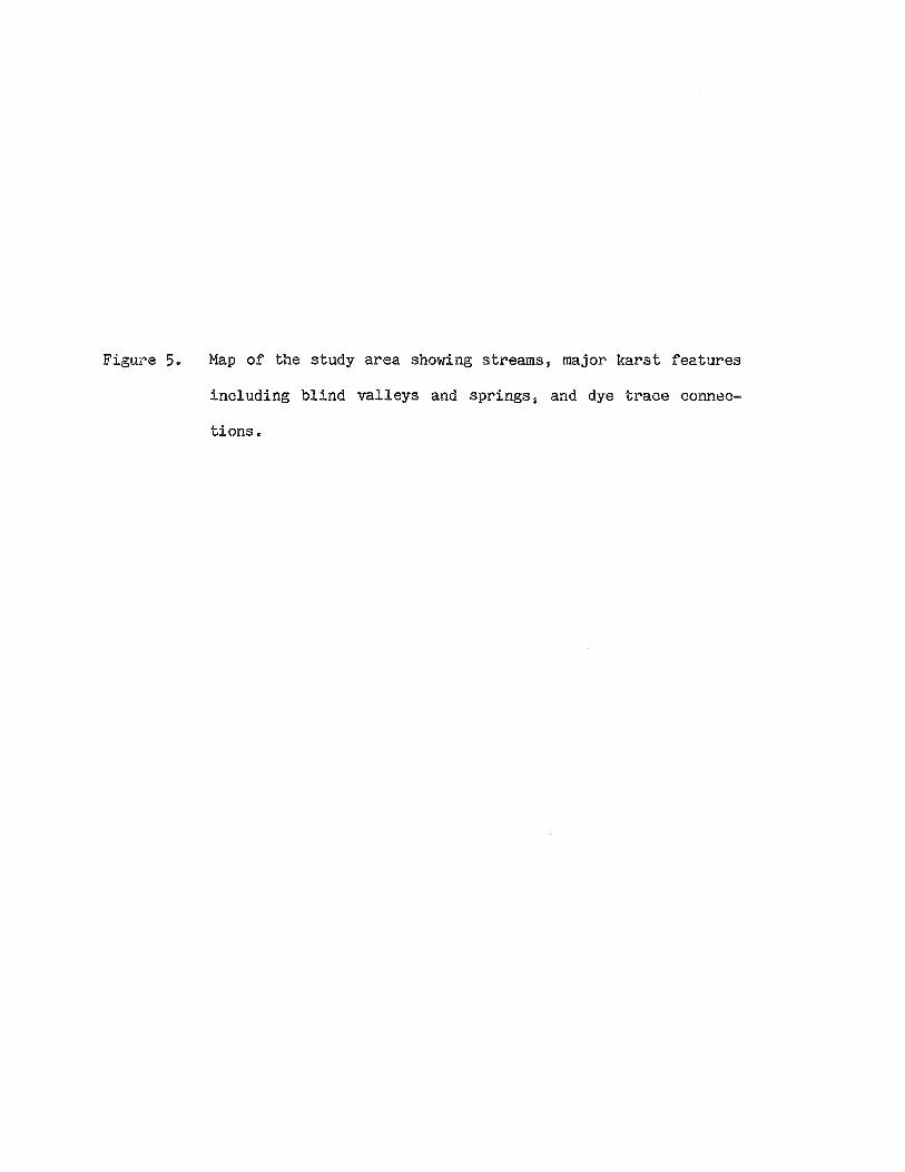
Figure 5. Map of the study area showing streams, major karst features
including blind valleys and springs, and dye trace connec
tions.

·,.
\
/
\,.{
r·
·,
( i \
\ ·, \
/- _,.<V
.\
(
' ( ·----
\
r
/'·1'
/'/ ( j i
( (
/ .i
(
· ....... /
··-. \ \
_ .. _ j
'-· \
/ /
)
·, \
r· .I
!/ . ..-·
,. \
)
/ i
/
,,.. .. -./· .r
/
·,. ·,
/ ! .....
.... t
\.., \
·, · .....
· ...... , } ·,. s.
(' .. ( i.. .• -.
Red Tail
I
\) ,..
) ........ I \
i/ \, .. _i
·., ·'··-----·-· EXPLANATION
·,. ·, .. _\
' ··\., Disappearing',, R. ' 1ver )· .. ,.
·, ·.,_
''·:,...,
\
\ \
·,.
,;
\ \ ·\ ..
·,
//,>?'--"· ·~~)~·~) /
\. ..
) j
j
;
/ .i-·
_./
' \ \ .,
/
·, ·,.
e-v spring
~ streamsink
;¢. cave entrance
~ dye trace connection
.i1. gaging station
® recording rain gage
scale
O .5 1mile
0 .5 ~
1 km
...... , ......... ) -.-- -~-· ..... _,...,_.,, -~ ·,. ·,
i I ,·
--·-----··- )._
·,. ___ .----·-··-. ·-..... -.....
\ //~.,,,.··--·----~ /
·,
N
r \ ___ ) [_ :'<
I f-' N I

-13-
South Branch of the Root River
The South Branch of the Root River (hereafter referred to as the
South Branch) flows eastward across the study area. Starting at
Disappearing River, at the entrance to Mystery I cave, it loses water to
a series of streamsinks along the river channel. Under low flow con-
ditions, the surface channel is completely dry from Matheson Sink
downstream to the resurgence at Seven Springs. Under high flow con-
ditions, water flows all the way along the surface channel.
Mystery Cave
Developed at or near the Dubuque/Galena contact, Mystery Cave acts
as a subsurface meander cutoff for the South Branch (Fig. 6). The plan
of Mystery Cave is almost totally controlled by joint orientations. The
cave contains over 18 km of surveyed passageways, some of which are tens
of square meters in cross section.
Seven Springs
At Seven Springs water resurges from several outlets along the base
of a wall of Galena Limestone and flows into the South Branch channel
(Fig. 7). The South Branch may or may not be flowing upstream from
Seven Springs, depending on the flow conditions, but the springs flow
year-round. There is another small outlet about 100 m northeast of
outlet 111. The discharge at Seven Springs averages around 300
liters/sec (9 cfs).

Figure 6. Location of Mystery Cave in relation to surface topography.
11T11 indicates the location of the First Triangle Room. From
Milske (1982).

t SCALE
0 500 1000 2000
NORTH
Contour Interval: 50 feet
3000 feet
1000 meters
Adapted from USGS 7.5 minute topographic maps: Wykoff, MN and Cherry Grove, MN.

Figure 7. Map of Seven Springs showing the different outlets. Adapted
from an original map prepared by R.C. Spong.

/ /
/
/
/ /
/
...,.15-
i2a o~
SEVEN SPRINGS & Fillmore County, Minnesota
(Sec. 21,Tl02N.,R.12W.)
Surveyed 2/ 8/80 by R.C. Spong
Bose• USGS 1 Cherry Grove 7-f, 1965
Contours ±5 feet
0 10
m - - - - I METERS
Nji-c-5, .!:
11 a g, ::;;
"' (D
0

-16-
Moth and Grabau Springs
Moth and Grabau Springs are major resurgences forming the head of
Forestville Creek (Fig. 8). Moth Spring is the larger of the two, on
the south side of the valley. The flow from the spring issues from a
cave opening in the base of a Galena cliff. Across the valley at Grabau
Spring, water flows from a series of small outlets along the base of the
hill slope. The flow from the two springs merges 75 m downstream from
Grabau Spring. The combined flow ranges from 400 liters/sec (14 cfs) to
over 8000 liters/sec (280 cfs). Forestville Creek flows for 3 km before
its confluence with the South Branch of the Root River. Forest ville
Creek is an important trout stream. It is the only stream in the state
of Minnesota supporting a naturally breeding trout population.
Fairview Blind Valley
Formerly known as Zimmer Blind Valley, Fairview Blind Valley is a
major karst sink draining an area of several square kilometers. A
perennial stream flows from the west and sinks into a number of stream
sinks (Fig. 9). The location of the terminal sink depends on flow.
Under low flow conditions the stream goes completely underground at the
west end of the valley. Under higher flow conditions the stream flows
to the east end of the valley before sinking. During extremely high
flow the whole valley may fill up for a few hours.
The valley floor is flat and alluviated. The valley is a window
through the Dubuque Formation into the Stewartville Member of the Galena
Formation. There is an extensive, recently discovered cave system
beneath Fairview Blind Valley which has not been thoroughly explored
(R.C. Spong, personal communication, 1981).

Figure 8. Map of Moth and Grabau Springs. Adapted from an original
map prepared by R.C. Spong.

/ / /
I / / ~ / A,,~/
/ /
/
/
~1,
--------- lf4o -------:--
GRABAU SPRING
l+-s•
MAG. l>ECUH.
-11301------
,,so---...... FORESTVILLE CREEK FILLMORE CO., MINNESOTA. 20 JULY 1980 SURVEY a CARTOGRAPHY BY R. SPONG. BASE: USGS WYKOFF 7,5' QUAD 1965.
I I-' --....] I

Figure 9. Map of Fairview Blind Valley, showing the various stream
sinks including Hellerud Sink A and Poldervaard Sink A.
Adapted from an original map prepared by R.C. Spong.

~4.7
"'
:;
w
"'
..,, ij 554.7
4.8 I . I 4,9 I
---x- - -
4.8
I I
1330-------1)\j
1320
1310-------t'
,.,_,,o
,,'2-o
4.9
I I I
5.0
x- - - - - - - - - - - - -I I t HELLERUD O ~
I I I I I
D
D
- - - -x I
~-----------
5.0
1320----..
51 5.2 53 : O .,_,,
VALLEY~' FAIRVIEW BLIND Fillmore County, Minnesota
I Sec. 6, TI02N., R.12W.)
Surveyed 12/31/79 by R.C. Spong
Base: USGS, Wycoff 7~, 1965
Air Photograph MHF- 3-179, 1979
0 100 200
- -- - ... .. ..... - - - I METERS
I I I
x- - - - - - - - -x- __£_ - - - - - - - - - - - - -x°- - - - - - - - -
5.1
I I I ,.,_,,o
5.2
,-,_,'1-0
,.,_,-,_,o
5.3
f "
555.4:§3
~ ..-
w
"'
.."' 5.4

-19-
Other Karst Features
There are many sinkholes in the upland plain north of Fairview Blind
Valley. One of the larger of these is Red Tail Sink, which accepts flow
from surficial seeps to the west (Fig. 5). Another major feature is
Lefevre Blind Valley, where an intermittent stream flowing from the
southwest sinks (Fig. 5). Natural Well is a small cave in the Prosser
Member of the Galena Formation (Fig. 10). There are many other karst
features in the study area, but the ones described above are most rele
vant to the hydrologic studies of this paper.

Figure 10. Map and cross-section of Natural Well. Adapted from an ori
ginal map prepared by R.C. Spong.

WELL HOUSE ,r:: ENTRANC& (Apprex.el4evflt1on) .tt!~ 12.i 5 .. T. MSL ....... __ _
±
GAlENAFM PROSSER MOO (ls)
~ ' ~· 19E,5
MA'1,. l)l!CLIN.
NATURAL WELL fllllll\ORE CO., MINNESOTA
SURVE.'< 21 Oct 1977 BY T.MARSHALL,R. VEN'<ATh
KRISHNAN ( R.SPONG. CAlttOGRAPHV R.SPONG.
BASE: USGS WVKOFF7!i.
SCALE
~ •5z -~,0 FT. o I :J. 3 M.
I N 0 I

-21-
III. QUANTITATIVE FLUOROMETRIC DYE TRACING
Tracers of various kinds have been used for many years in the study
of karst groundwater flow. A tracer is introduced into a sinkhole or
sinking stream and detected or recovered at one or several spring
resurgences. Fluorescent dyes, minute biological materials such as
Lycopodium spores or bacteria, soluble salts, and radioactive materials
are examples of tracers used in various studies (Aley and Fletcher,
1976). An ideal tracer should have the following properties: 1) its
introduction into the subsurface should be easy; 2) it should be easily
detectable or recoverable at the resurgence points; 3) its flow velocity
should approximate that of its host water; 4) its adsorption onto the
aquifer material should be minimal; and 5) its potential for harmful
environmental effects should be small.
The fluorescent dye Rhodamine WT, used in this study in conjuction
with a field fluorometer, adequately satisfies these requirements. The
fluorometer (a Turner Designs model 10-005) is capable of accurately
measuring dye concentrations down to a fraction of a part per billion.
The advantage of the fluorometric technique is that the concentration of
dye as it emerges from a spring resurgence can be monitored, yielding
quantitative travel time and dispersion data.
Rhodamine WT can also be used semi-quantitatively by placing a
packet of activated charcoal in a spring resurgence. If dye emerges
from the spring, it will adsorb onto the charcoal. The packet can then
be collected and analyzed for dye.

-22-
Methods
The basic procedure used in this study was as follows:
1. An input point (sinkhole or sinking stream) and resurgence points
(springs) were chosen.
2. Packets of activated charcoal were placed in all the suspected
resurgences, since it was not possible to monitor every spring with
the fluorometer.
3. A known quantity of Rhodamine WT was injected at the input point.
4. Discharge measurements of the spring(s) were taken. At first this
was done by measuring the cross-sectional area of the stream and
measuring the velocity of floating or suspended objects at intervals
along this cross-sectional plane. After the first several traces,
flow measurements were done using a dye dilution technique. Dye of
known concentration C0 was injected in the spring at constant rate
q, using a Mariette vessel constant head injector device (see Cobb,
1968). After equilibrium was established, the downstream con
centration C was measured with the fluorometer. The discharge Q was
then determined using the formula:
Q = q ( 1) c
5. The concentration of the dye as it emerged from one spring or
several springs was monitored for as long as possible.
6. The final step on leaving the field was to change the charcoal
packets in all the springs in order to catch any dye that might not

-23-
have been detected and to measure long-term washout. The charcoal
packets were analyzed for Rhodamine using the technique of Aley and
Fletcher (1976).
Data Analysis
The fluorometric data were plotted as concentration versus time
curves. These pulse response curves contain information about the tra-
vel time and dispersion of the subsurface water. Also, the area under
such a curve is proportional to the amount of dye discharged from the
spring:
(X)
m = JQ(t)c(t)dt
0
where m = mass of dye recovered c(t) = dye concentration in spring Q(t) = spring discharge
(2)
If spring discharge is constant over the period of the trace (a tenuous
assumption), Q can be taken outside of the integral. Using this rela-
tionship it is possible to perform mass balance calculations, thereby
determining what proportion of the water entering a given sink point
emerges at a given resurgence. When several springs are being moni-
tored, it is possible to determine how the water entering a given sink
is partitioned among several resurgences.
The concentration versus time curves were integrated numerically,
using a simple trapezoidal formula. The tails of the curves were extra-
polated using an exponential decay rule, and the areas under the extra-
polated tails were determined analytically. The tails contained a

-24-
significant proportion of the total area. The total area under each
curve was multiplied by the measured spring discharge to determine the
mass of dye recovered (equation 2). This was compared to the amount of
dye injected to derive a percentage dye recovery. The greatest uncer
tainties in this analysis are in the discharge measurements.
Results
Figure 5 shows all the quantitative fluorometric dye traces
accomplished in the study area. The traces will be discussed one by
one, with most of the information appearing in figures. The data from
the dye traces is in Appendix A.
Disappearing River to Seven Springs, Oct • .!.Q..z. 1979 (Figure 11)
This was the first of several traces to Seven Springs. Dye was
introduced at the commercial entrance to Mystery I Cave, where the South
Branch first starts losing water to the subsurface. The flow conditions
were relatively low, with the South Branch going completely underground.
It is interesting that the various outlets at Seven Springs, which are
only a few meters apart, responded differently from one another. The
response at outlet /11 peaked at a lower concentration and was more
dispersed than the responses of the other outlets. When the curves are
averaged, the resulting curve represents an 89.5% dye recovery. Given
the uncertainty of the flow measurements and the inaccuracies introduced
by a simple averaging of the pulses, this represents essentially
complete dye recovery.

Figure 11. Disappearing River to Seven Springs, Oct. 10, 1979 Time of dye drop: 3:13 a.m., October 10, 1979, at Mystery I
Cave entrance. Amount, type of dye: 914 g Rhodamine WT 20% solution Horizontal distance: 2.38 km (1.48 miles) Vertical drop: 18 m (60 ft) Arrival of leading edge of dye pulse: 7.75 hours Arrival of peak dye concentration: 10 hours Flow measurements: 259 liters/sec (measured with tape and
stopwatch) Dye budget calculations: 89.5% of dye recovered Springs where dye did not emerge: Moth Spring, Grabau
Spring, Cold Spring The numbering of the outlets is shown in Figure 7.

8 10 12 14 16 28 30 32 40 40
35 SEVEN SPRINGS 35
..... 30 I- • ro - -i 30 m a. a. ---~ 25· I- .. 1....:-· 1 ' \: -i 25 .... c .... .... c
i 20 ~ (.)
t I I \~ ~ 20
I-3::
; 15 I- ~1 1' -I 15 E c -0 0 .c 0::
10 I- I/ \ ..... ').,. -I 10
5 5
=1:1=,,2,3 - - - - 7"""T-.-r-r ......... ~ * 9 .•... ···,·· I I ~7,Blo L-~~-.L _ _L _ ___l __ ~, ;---L• -~·~·:...._----1•-1 ~• ;---''1 11 1
218
30 32 I I I o• ...., . 8 10 12 14 16
Hours After Dye Injection In Disappearing River
I N (.J1
I

-26-
Disappearing River to Seven Springs, Sept. £!. 1980 (Figure 12)
The flow conditions were much higher during this trace than for the
previous trace from Disappearing River to Seven Springs, with the South
Branch flowing all the way along its surface channel. The spring
response differed markedly from that of the first trace. The responses
for the different outlets form a nestled family of curves, with the
higher numbered outlets showing the highest concentrations. All curves
show the same dispersion through time, and all have a second peak with a
lag time of 3 hours after the first peak.
The double-peaked response curves can be best explained by a
divergence in the flowpath, followed by a later reconvergence, with dif
ferent travel times associated with each pathway. The fact that the
double peak occurs under high flow, but not under low flow conditions
suggests that the alternate pathway is an overflow channel available
only under high flow conditions.
The nestled pattern of the response curves is best explained by
varying degrees of dilution of essentially the same pulse by undyed
water from another source. The diluting water could be sinking in
streamsinks in the South Branch downstream from Disappearing River, such
as those between Matheson Sink and Seven Springs (see Fig. 5), and pre
ferentially travelling to the lower numbered (northernmost) outlets of
Seven Springs. Under high flow conditions, when water is flowing all
the way along the surface channel and sinking into these downstream
sinks, the response curves show increasing dilution from high to low
numbered outlets at Seven Springs. Under low flow conditions, there is
little or no water infiltrating in these sinks, so the response curves

Figure 12. Disappearing River to Seven Springs, Sept. 2, 1980 Time of dye drop: 6:00 a.m., September 2, 1980, at
Mystery I Cave entrance Amount, type of dye: 266.3 g Rhodamine WT 20% solution Horizontal distance: 2.38 km (1.48 miles) Vertical drop: 18 m (60 ft) Arrival of leading edge of dye pulse: 6.75 hours Arrival of peak dye concentration: 8.25 hours Flow measurements: Seven Springs - 309 liters/sec (measured
by dye dilution) The numbering of the outlets is shown in Figure 7.

-27-
!?
.....
'° ...
ID Cit > a: D c: • ... Cl • Q. Q. Cl ,,, • Q
c: ... .,, ~ • Cl) Q.
Q. ~ 0
~ ... Q
Q: • ~ >-
Q
~ ... •
2 -.. ~ c '4.a • Cl) ...
:II
~ 0
%
N CID

-28-
do not show as pronounced a pattern of increasing dilution from high to
low numbered outlets.
Formation Route Creek to Seven Springs, Aug. E2l. 1980 (Figure 13)
Formation Route Creek flows through the northwestern portion of the
Mystery Cave system, or "Mystery III Cave". Dye was injected beneath a
room known as the "First Triangle Room", where the creek is accessible
(see Fig. 6). Water was flowing all the way along the surface channel
of the South Branch at the time.
The pulse response curves are nestled as in the second trace from
Disappearing River to Seven Springs, except that there is no second
peak. Again, the lower numbered (northernmost) outlets had the lowest
concentration. This further supports the idea that the lower numbered
outlets are preferentially fed by a source not associated with the
Mystery Cave system, such as the sinks on the South Branch between
Matheson Sink and Seven Springs.
Matheson Sink to Seven, Moth, and Grabau Springs, Oct. 20-21, 1979 (Figure 14_)_
In this dye trace water was simultaneously traced from Matheson Sink
on the South Branch to Seven Springs, Moth Spring, and Grabau Spring,
and all three pulses were monitored. Under low flow conditions,
Matheson Sink can act as the terminal sink of the South Branch before it
resurges at Seven Springs.
The dye pulse first arrived at Seven Springs. The response was
similar to that of the first (low flow) trace from Disappearing River to
Seven Springs. The pulse at outlet #1 had a slightly lower peak and was
slightly more dispersed than at the other outlets.

Figure 13. Formation Route Creek {Mystery Cave) to Seven Springs, August 25, 1980 Time of dye drop: 10:19 a.m., August 25, 1980, under First
Triangle Room in Mystery III cave Amount, type of dye: 309.3 g Rhodamine WT 20% solution Horizontal distance: 1.63 km (1.02 miles) Vertical drop: 6 m (18 ft) Arrival of leading edge of dye pulse: 5.0 hours Arrival of peak dye concentration: 6.25 hours Flow measurements: Seven Springs - 220 liters/sec (measured
by dye dilution) Springs where dye did not emerge: Moth and Grabau Springs The numbering of the outlets is shown in Figure 7.

-.a a. Q, -
I&
-29-
SEVEN SPRINGS
15 Houn After Dye Dropped In Formation Route Creek

Figure 14. Matheson Sink to Seven Springs, Moth Spring and Grabau Spring, October 20-21, 1979 Time of dye drop: 6:35 a.m., October 20, 1979 Amount, type of dye: 1118 g Rhodamine WT 20% solution Horizontal distance: Seven Springs - 1.72 km (1.07 miles)
Grabau Spring - 3.86 km (2.40 miles) Moth Spring - 3.82 km (2.37 miles)
Vertical drop: Seven Springs - 12 m (40 ft) Grabau Spring - 26 m (85 ft) Moth Spring - 26 m (85 ft)
Arrival of leading edge of dye pulse: Seven Springs - around 8.5 hours Grabau Spring - 13.17 hours Moth Spring - 18.67 hours
Arrival of peak dye concentration: Seven Springs - 10.17 hours Grabau Spring - 16.58 hours Moth Spring - 23.67 hours
Flow measurements: Seven Springs - 242 liters/sec Grabau Spring - 157 liters/sec Moth Spring - 381 liters/sec (measured with tape and stopwatch)
Dye budget calculations: Seven Springs - 5.8% (4.5%) of dye Grabau Spring - 34.3% (26.6%) of dye Moth Spring - 89.0% (68.9%) of dye (numbers in parentheses have been scaled down to
100% dye recovery) Springs where dye did not emerge: Cold Spring The numbering of the outlets of Seven Springs is shown in Figure 7.

20
m t 15 I-~
c: 0 ....
I c .... .... c: Q)
0 c: 0
u 10 I-I-3: Q)
c: -E c
"C 0
.s:: a::
5 I-
10
;:)t:.Vt:.N
15
GRABAU SPRING
I
I I
I
\
20
I
\ j \ J
I '\..
25
MOTH SPRING
,
\ \
\
30
20
--l 15
I -I 10
-I 5
IY ·~ I -- I 0 , f* , e , 0
10 15 20 25 30 Hours After Dye Injection At Matheson Sink
I lN 0 I

-31-
Most of the dye emerged at Moth and Grabau Springs. The subsurface
connection between the South Branch of the Root River and Forestville
Creek was suggested in 1958 when souvenirs from the Mystery Cave con
cession stand, which had been washed away in a flood, were found below
Moth Spring. It is surprising that the Moth Spring response curve lags
behind that of Grabau Spring by almost six hours. Not only is Grabau
Spring farther away from Matheson Sink than Moth Spring, but it is
across the deeply incised stream valley of Forestville Creek (see Figs.
5 and 8). The discharge from Moth Spring is also much greater than that
from Grabau Spring. A partial explanation for the surprising travel
times lies in the nature of the spring openings. Inside the Moth Spring
cave entrance is a large pool which overflows to produce the spring
outflow.
outlets.
The output from Grabau Spring comes from isolated small
The mixing time for the large reservoir inside Moth Spring
cave could account for some of the increased dispersion and travel time
for the dye pulse. However the peak concentration of the Moth Spring
response is greater than that of Grabau Spring, so there is more going
on than simple lagging and routing through a reservoir. Whatever the
mechanism, the connection to Grabau Spring is shorter and involves less
dispersion than that to Moth Spring.
The mass balance calculation for this trace produced a 129.1% dye
recovery (Fig. 14). This is clearly impossible, and due no doubt to
inaccurate flow measurements. Figure 14 also gives numbers wich have
been scaled down to 100% recovery. It is interesting that over 90% of
the water which infiltrates at Matheson Sink gets pirated off to another
drainage.

-32-
Fairview Blind Valley to Moth and Grabau Springs
Two traces were done from Fairview Blind Valley, one under high flow
and one under low flow conditions. As mentioned before, under high flow
conditions the stream flows all the way to the end of the valley,
finally disappearing in a collection of sinks known as the Hellerud
Streamsinks (Fig. 9). Under low flow, the stream makes it only as far
as the Poldervaard Streamsinks.
High Flow Hellerud Sink 'A' to Moth and Grabau Springs, Nov. 17-21, 1979 (Figure 1~ - - -- -
The terminal sink on November 17, 1979 was identified as Hellerud
Sink 'A' to distinguish it from the other Hellerud Streamsinks (see Fig.
9). The response curves show several interesting features. Again, the
Moth Spring response lags behind the Grabau Spring response, this time
by two hours. Notice the similarity in shape of the two curves, and the
pronounced double peak in both. Some of the water takes a faster path,
producing the first peak, while most of the water takes a second, slower
path, producing the main, larger peak. The similarity of the two curves
indicates that the divergence and reconvergence occur before the final
split between the flows of Moth Spring and Grabau Spring.
Low Flow Poldervaard Sink 'A' to Moth and Grabau Springs, July 13-22, 1980 (Figure 16)
The terminal sink on July 13, 1980, was one of the Poldervaard
Streamsinks, and was identified as Poldervaard Sink 'A' (see Fig. 9).
Note that the travel time is twice that from the downstream (Hellerud)
sink of Fairview Blind Valley. The Moth Spring response lags by 6-9

Figure 15. Fairview Blind Valley (Hellerud Sink A) to Moth and Grabau Springs, November 17-21, 1979 Time of dye drop: 3:30 p.m., November 17, 1979 Amount, type of dye: 863 g Rhodamine WT 20% solution Horizontal distance: Moth Spring - 5.64 km (3.50 miles)
Grabau Spring - 5.66 km (3.52 miles) Vertical drop: 47 m (155 ft) Arrival of leading edge of dye pulse:
Grabau Spring - 40.25 hours Moth Spring - 42.25 hours
Arrival of peak dye concentration: Grabau Spring - 65.5 hours Moth Spring - 67.5 hours
Flow measurements: Grabau Spring - 153 liters/sec Moth Spring - 1281 liters/sec (measured with tape and stopwatch)
Dye budget calculations: Grabau Spring - 12.5% (10.9%) of dye Moth Spring - 102.4% (89.1%) of dye (numbers in parentheses have been scaled down to
100% dye recovery) Springs where dye did not emerge: Cold, Stagcoach, Freiheit,
Barr, Narcissus, Mahood Springs

40 45 50 55 60 65 70 75 80 85 90
[ 2,0 ~ ~ \ MOTH ~ 2.0 SPRING
GRABAU SPRING
c 0 .... Cl .... ....
L I/ \\ J I c l:..N
G) l:..N () I c 0 u I- 1.0 ~ r r \ \ -l 1.0 3,:
G)
c E Cl
"Cl 0
.s:::. 0::
40 45 50 55 60 65 70 75 80 85 90 Hours After Dye Injection At Fairview Blind Valley

Figure 16. Fairview Blind Valley (Poldervaard Sink A) to Moth and Grabau Springs, July 13-22, 1980 Time of dye drop: 6.36 p.m., July 13, 1980 Amount, type of dye: 1203 g Rhodamine WT 20% solution Horizontal distance: Moth Spring - 5.96 km (3.70 miles)
Grabau Spring - 5.97 km (3.71 miles) Vertical drop: 50 m (165 ft) Arrival of leading edge of dye pulse:
Grabau Spring - 92.5 hours Moth Spring - 98 hours
Arrival of peak dye concentration: Grabau Spring - 111.4 hours Moth Spring - 120.4 hours
Flow measurements: Grabau Spring - 70 liters/sec Moth Spring - 332 liters/sec (measured by dye dilution)
Dye budget calculations: Grabau Spring - 15.2% of dye Moth Spring - 74.5% of dye

7.---~~~~,-~~~~--,--~~~~-.-~~~~~..-~~~~-.-~~~~-.-~~~~-..~~~~----.~~~~~..-~~~~-.-~~~~-.-~~~~~
6
GRABAU
- 51 SPRING
..a 0.. 0.. -c 0
0 4 .... -c a,
I I u c 0 u
..... 3 3: G)
c
E c ,:,
_g 2 a:
90 100
I \
110 120
\
130 140 150 160 170
Hours After Dye Dropped at Poldervaard Sink (Fairview Blind Valley Upstream Sink)
I
180 190 200 210
I (.N ~ I

-35-
hours, and there is no pronounced double peak.
The difference between the high flow and low flow response curves
are best explained by the level of water in the aquifer. Under high
flow conditions, the large conduits are more nearly full, and water is
flowing at a higher velocity. There are alternate overflow channels
available, which can produce double-peaked response curves as in Figure
15. In the case of Figure 15, most of the water travelled the slower of
the alternate pathways, while a smaller amount took a II short cut".
Under low flow conditions, the main conduits are not full, so the flow
is slower, and overflow passageways are not available. The same pattern
shows up at Seven Springs: high flow conditions produce a double peak,
while low flow conditions produce a single-peaked response.
Figure 17 gives a simplified, schematic cross section of the flow
between Fairview Blind Valley and Moth and Grabau Springs. The figure
does not by any means represent all the complexities of the system. It
simply shows the kind of conduit geometry which could produce the
observed results. Moth Spring is shown as being farther away from
Fairview Blind Valley than Grabau Spring. This is to show that the
distance along the flowpath is longer, and does not reflect the areal
geometry.
Natural Well to Moth and Grabau Springs, May 12-17, 1980 (Figure 18)
Natural Well is a small cave in the Prosser Member of the Galena
Formation (Fig. 10). A small stream of water sinks into the floor of
the cave, and this is where dye was injected.
As in other traces to Moth and Grabau Springs, the Moth Spring
response lags behind the Grabau Spring response. There are some unusual

Figure 17. Schematic cross-section of the subsurface flowpath between
Fairview Blind Valley and Moth and Grabau Springs, showing
one kind of conduit geometry which would produce the
observed dye trace response curves.

--Q
> "O c: ·-·-> .. -
-36-

Figure 18. Natural Well to Moth and Grabau Springs, May 12-17, 1980 Time of dye drop: 4:00 p.m., May 12, 1980 Amount, type of dye: 404.8 g Rhodamine WT 20% solution Horizontal distance: 1.83 km (1.14 miles) Vertical drop: 17 m (55 ft) Arrival of leading edge of dye pulse:
Moth Spring - 55 hours Grabau Spring - 51.5 hours
Arrival of peak dye concentration: Moth Spring - 66.5 hours Grabau Spring - 61.0 hours
Flow measurements: Moth Spring - 421 liters/sec Grabau Spring - 92 liters/sec (measured by dye dilution)
Dye budget calculations: Moth Spring - 44.1% of dye Grabau Spring - 9.9% of dye
Springs where dye did not emerge: Root Spring

-37-
0 N
a ... ::, -a z c
,:,
• Q, Q,
0 ... Q
... • -... ct

-38-
oscillations near the peaks of both curves. The response curves cannot
account for all of the dye, suggesting that some of the water
infiltrating at Natural Well might be emerging elsewhere. Root Spring,
located 1 km northeast of Moth Spring, showed no positive response.
Red Tail Sink to Moth and Grabau Springs, June 28 - July 2.t_ 1980 (Figure 1gy- - -- -
Red Tail Sink is a large sinkhole north of Fairview Blind Valley,
which drains the outflow from several surficial seeps when they are
flowing. The sink is near the topographic divide between the drainages
of the Middle and South Branches of the Root River.
The travel time to Moth and Grabau Springs is relatively long and
the response curve is fairly dispersed. While the dye recovery is less
than complete, dye was not detected at any neighboring springs. The
characteristic lag of the Moth Spring response is present.
Lefevre Blind Valley to Moth and Grabau Springs, October 7-10, 1980 (Figure 20)
Lefevre Blind Valley is a major sink draining an intermittent
stream. When flowing, the stream drains into several streamsinks at the
end of the valley, and this is where dye was injected.
The response curves were fairly typical for Moth and Grabau Springs.
Data from the initial rise of the curves is missing, and was approxi-
mated by an exponential rise for the dye budget calculations.
Root River Dye Traces
The Root River dye traces were large scale dye trace experiments
performed in August of 1981 and August of 1982. In each case, a large
pulse of dye was injected into the South Branch south of Spring Valley

Figure 19. Red Tail Sink to Moth and Grabau Springs, June 28-July 9, 1980 Time of dye drop: 10:10 a.m., June 28, 1980 Amount, type of dye: 1325 g Rhodamine WT 20% solution Horizontal distance: 6.69 km (4.16 miles) Vertical drop: 58 m (190 ft) Arrival of leading edge of dye pulse:
Grabau Spring - around 77 hours Moth Spring - around 81 hours
Arrival of peak dye concentration: Grabau Spring - 99.5 hours Moth Spring - 102 hours
Flow measurements: Grabau Spring - 82 liters/sec Moth Spring - 455 liters/sec (measured by dye dilution)
Dye budget calculations: Grabau Spring - 12.6% of dye Moth Spring - 75.3% of dye
Springs where dye did not emerge: Mahood, Barr, Narcissus, Freiheit, Stagecoach, Root, Cold, Seven, Frost, and Bartsch Springs

-39-
....... ~~~~~~~~----,.--~~~~~~~~~....-~~~~~~~~--.g
/" I / I
I I
/ I / I
jf / I
/ I / I
/ / / /
N
0 .ac st c N ·-Cl)
Cl .... 0 ,:, it> • - a::
-C(
,:, 0 • N a. - : ...
0
• :,,.
00
= = --C(
• 0 ... 0 :, - 0
0 en
0 Cl)
:::c
L-~~~~~~~--'-~L-~~~~~~~~~L-~~~~~~~~---g N
( qdd) UO!'DJJUG:>UO:) .1.M 9U! WDpOIU:l

Figure 20. Lefevre Blind Valley to Moth and Grabau Springs, October 7-10, 1980 Time of dye drop: 5:00 p.m., October 7, 1980 Amount, type of dye: 895.4 g Rhodamine WT 20% solution Horizontal distance: Moth Spring - 4.65 km (2.89 miles)
Grabau Spring - 4.68 km (2.91 miles) Vertical drop: 52 m (170 ft) Arrival of leading edge of dye pulse: missed exact arrival
time Arrival of peak dye concentration:
Grabau Spring - 46.33 hours Moth Spring - 48.5 hours
Flow measurements: Grabau Spring - 90 liters/sec Moth Spring - 512 liters/sec (measured by dye dilution)
Dye budget calculations: Grabau Spring - 8.0% of dye Moth Spring - 47.2% of dye

5
-.a
h MOTH a. a.
SPRING -~ 4 GRABAU -ID SPRING ... -c • u
II \ \ i ~ 31 I ..p. 0 I
.... ~
• c ·- 2 E ID 'a 0 .I: II:
I
40 45 50 55 60 65 70 Hours After Dye Dropped In Lefevre Blind Valley

-41-
over a period of several hours. The pulse was monitored as it travelled
down the river, and as it emerged from Seven Springs, Moth Spring, and
Grabau Spring. Residential wells in the area were also monitored. The
purpose of the traces was to determine the potential flowpath of toxic
chemicals from the Ironwood Sanitary Landfill, a facility which had
illegally received some hazardous waste.
To provide a complete description of these dye traces is beyond the
scope of this paper. I will present only the response curves for Seven
Springs, Moth Spring, and Grabau Spring, which are a small fraction of
the total data set.
The distinguishing feature of these experiments is that they traced
the entire flow of the South Branch of the Root River, rather than the
small amount which enters one particular sink. The spring responses
reflect the combination of pulses produced as dye travelling down the
South Branch sequentially entered strearnsinks in the river bed.
August 1981 Root River Dye Trace - High Flow
The dye, 50 pounds of Rhodamine WT 20% solution, was injected over a
five hour period from 10:20 a.m. to 3:20 p.m. on August 1, 1981. It was
diluted to about 450 liters of 1% solution and siphoned into the river
at about 1.5 liters/min. Figure 21 shows the injection points for both
the 1981 and 1982 Root River dye traces. The river was flowing at about
600 liters/sec and the Rhodamine WT was immediately diluted to about
400 ppb.
From about 2:00-3:00 p.m., a heavy thunderstorm dropped over an inch
of rain over the study area. Etna Creek, which empties into the South
Branch 2 km below the injection point, flash flooded. High water con-

Figure 21. Map of the study area showing the dye injection points for
the 1981 and 1982 Root River dye traces and the location of
Ironwood Sanitary Landfill.

\
\ \
\. ·, \
,,.. .. - .. _ . .r<J./
·., ~
{ \ ,..
\ I
·,. ·,
/·'-. . ...,
r·· ·...... ·r ·-··,..··-··-· \
/ / ./ ..... · /
/
~ .. ./
r .,.
i
·-··- i
\
'-· \
i ( ..... i
/
~ LANDFILL\ ~ .
,..(7
l'.lo~
,..,.1·
/',,... (. ) i
{
/ i
(
/ j
/
!' ... -./ (
I
,, (
< "
rZ. \. .......
Red Tail
·,. ·,
I
\.) i ·.'l- .. ,.
\
' ·,
/
j'
\ ·,. :r··-...
· ........ ·,.
\ \ ·,.
( >(>- '··-'~- ~~, f)
j
\
'· \ /
·,.
EXPLANATION
..,., spring
-3- streamsink
~ cave entrance
+- dye trace connection
.i. gaging station
® recording rain gage
scale 0 .5 1mile
0 .5 ~
-.. ,··-... .-.·- .~ ........ ,..,.,,,) ·,
1.
I .I
.'.
1 km
\··-··.--··-··-,
!/~.,.,.·-··-··: /
,«:
N
t
I ..,. N I

-43-
di tions prevailed for the duration of the experiment, with the South
Branch flowing continuously in its surface channel from Matheson Sink to
Seven Springs.
The response curves at Seven Springs (Fig. 22) have higher peak con
centrations and lower peak dispersion for the lower numbered outlets, a
markedly different response than that of traces from Disappearing River
and Formation Route Creek under high flow conditions (Figs. 12 and 13).
The response is consistent with the earlier interpretation that sinks on
the South Branch between Matheson Sink and Seven Springs preferentially
feed the lower numbered outlets. In this case, the sinking water was
augmenting rather than diluting the responses at the lower numbered
outlets since the entire flow of the South Branch was being traced. The
response curves are more dispersed at the higher numbered outlets
because the water had to travel a longer distance underground.
The response at Moth and Grabau Springs is fairly typical (Fig. 23).
The response curves are similar in shape, with that of Moth Spring
lagging by about an hour, and having a higher peak.
August 1982 Root River Dye Trace - Low Flow
The dye, 50 pounds of Rhodmine WT 20% solution, was injected from
8:45 AM to 9:10 PM on August 7, 1982. Conditions were very dry, with
the South Branch going completely underground just downstream from
Matheson Sink.
The Seven Springs response curves (Fig. 24) are similar to those
of the low flow dye trace from Disappearing River to Seven Springs. The
outlet /11 response has a slightly lower peak and is slightly more
dispersed than that of the higher outlets. "Outlet /10 11 , a small,

Figure 22. Seven Springs response curves for the 1981 Root River dye
trace (high flow conditions).

CD u 0 !'.....
E-i
CD ::T)
D
!'..... CD > _ _)
0::::
~ 0 0
0::::
D n
(f)
m c
_ _)
!'..... 0....
en c 0)
> 0)
en
LI)
0J
-44-
l
I
i I I :
# Lfil 9£1
c.__ ....____ --------- ----- -
0 (\J
--~~
0 Lr) ...... D
Q)
-i-> 0
0
_...)
0) :J m :J
a:

Figure 23. Moth and Grabau Springs response curves for the 1981 Root
River dye trace (high flow conditions).

7
I (\
t 61 I \. 1981 Rool RLver O~e Trace
I \ c 5 0
I \ •. .J .+J 0
I \ L .,_) 4 c
I
\0 (I)
Molh Sprlng 0 I I
c I
..,. (.11
0 I
u '3
I Grabau S~~
f:-; ---.3:
(I) I \ c .. .J 2
I \ E 0 "'( u
t 0 ..c ~ Cl:: 1 /J
Ou 2 3 4 5
Augusl 1981 Dale

Figure 24. Seven Springs response curves for the 1982 Root River dye
trace (low flow conditions).

80--.--------------------------------------------------------------------------
70
.f.A 1982 Rool RLver D~e Trace
r-,
_o 0... 0...
._, 60 ci c 0
. .J .~( ..+J O so L e . .._)
c
l Seven Spr~ngs (!_)
Ll 40 ·~ I ~ c .i:tO 0 -u
t .ttl [;---; ------3: 30 .tt2 ---------·
(!_)
l c tt9 .. )
1 E 20 0
-0 0
f _c (Y
10 f a I .L
9 10 11 12 13 14
August 1982 Date

-47
recently discovered spring about 100 m north of outlet #1, is a delayed
and more dispersed version of the Seven Springs response curves.
The Moth and Grabau response curves again show the typical pattern
(Fig. 25). The curves have similar shape. The Moth Spring response is
delayed by 6.5 hours, and is slightly more dispersed.
Inter-Basin Connection
The data from the 1982 Root River dye trace, together with discharge
measurements taken at Moth and Grabau Springs and along the South
Branch, can be used to estimate the amount of water being transferred
from the South Branch to Moth and Grabau Springs. Discharge measure
ments along the South Branch were taken by workers from the Minnesota
Pollution Control Agency (MPCA) during the experiment. The discharge of
Moth and Grabau Springs was being monitored by a gauging station,
described in section IV.
One way of estimating the inter-basin transfer is to compare the dye
pulse as it passed by Matheson Sink with the pulse at Moth and Grabau
Springs. A measure of dispersion is the width of the pulse at! maxi
mum. This width was 19. 7 hours for Moth Spring, 19 hours for Grabau
Spring, and 17-18 hours for the South Branch near Matheson Sink. The
peak dye concentration, however, was four times greater at Matheson Sink
than at Moth and Grabau Springs. Since the peak widths are similar, a
crude but useful assumption can be made--that there was no dispersion
of the pulse between the South Branch and Moth and Grabau Springs, i.e.,
that the inter-basin transfer can be approximated by "plug-flow". This
implies that the reduction in peak dye concentration between the South
Branch and the springs is the result of dilution only. The measured

Figure 25. Moth and Grabau Springs response curves for the 1982 Root
River dye trace (low flow conditions).

m 0 0 L
E-i
Q) ::J')
0
L Q)
> _ _j
a::: ~ 0 0
a::: N co m ~
I l.f) N
m c ..i::. • ..) ~ (. O Q.
l::U')
0 N
-48-
LO ......
'!;" ......
t""1 ......
(D .,...) 0
C)
N co N 0) -~ ~ (jj ::, en ::,
cc
...... -
0 -
0 U1 0 .....

-49-
combined discharge of Moth and Grabau Springs was 530 liters/sec, and
according to this line of reasoning, ~ of this discharge, or around 130
liters/sec, was coming from the South Branch.
This number agrees well with the MPCA flow measurements. The
measured South Branch discharge at Disappearing River was 370 liters/
sec, and downstream from Seven Springs was 240 liters/sec. According to
this estimation, of the total South Branch discharge of 370 liters/sec,
240 liters/sec resurged at Seven Springs and 130 liters/sec was trans
ferred to Moth and Grabau Springs.
Another estimation of the inter-basin transfer comes from mass
balance calculations. Equal amounts of dye were accounted for at Moth
and Grabau Springs and at the South Branch below Seven Springs, indi
cating that of the water that infiltrated, half resurged at Seven
Springs and half resurged at Moth and Grabau Springs. This puts the
amount of the inter-basin transfer at 185 liters/sec.
These figures are useful estimates of the inter-basin transfer under
low flow conditions. There is probably a maximum possible inter-basin
transfer, limited by the infiltration capacity of the sinks along the
South Branch. Once this capacity is reached, additional water flowing
in the South Branch will have a negligible effect on the amount of water
being transferred to Moth and Grabau Springs. A similar case was
described by Milanovi~ (1976) in his investigation of the Ombla Spring
drainage area in the Dinaric karst of Yugoslavia. There, input from the
Trebisnjica River to the spring drainage system is limited by infiltra
tion capacity of the river bed, and is insignificant when compared to
the total water resources of the spring drainage area. It is unfor-

-50-
tunate that discharge measurements were not available for the 1981 Root
River dye trace. These would have been useful for estimating the
infiltration capacity of the sinks in the South Branch under high flow
conditions.
Summary and Conclusions
The dye trace studies have revealed information about the subsurface
flowpaths in the study area, and about travel time and dispersion along
the flowpaths under varying hydrologic conditions. The traces document
interesting and important hydrologic phenomena. In summary:
1. Seven Springs responds in complex ways depending on where the South
Branch is sinking and how much water is flowing.
2. Part of the South Branch sinks and resurges at Seven Springs, while
part is transferred to Moth and Grabau Springs. The amount of this
transfer is approximately known, and probably is limited by the
infiltration capacity of the river bed.
3. Alternate subsurface flowpaths exist, especially under high flow
conditions, as shown by double-peaked response curves. These are
probably subsurface overflow channels.
4. Moth and Grabau Springs are a major resurgence, receiving flow from
a number of sinks and karst blind valleys. They act as a single
resurgence. The travel time to Grabau Spring is invariably less
than that to Moth Spring, sometimes contrary to geometric intuition.
Figure 26 is a schematic flow chart interpretation of the dye trace
data.
The dye trace results can be used to estimate the recharge area for

Figure 26. Schematic flow chart interpretation of the dye trace data.

-·-• ,_--~~---, ,, G a:
-
--~ at
-CID ... :, -Cl
2
-51-
0 ~
I I
, ...... I \ \
,. .) ' .,. ...
.... 0 0 cc

-52-
Moth and Grabau Springs. Figure 27 shows this recharge area, which has
an area of 40.7 km2 (15.7 sq. miles). This estimation is not rigorously
correct, because as we have seen, the springs receive some input from
the South Branch, which has a drainage area of 153.7 km2 (59.3 sq.
miles) upstream from Matheson Sink. A more precise definition of the
recharge area of the springs would somehow account for this additional
area. One way to approach the problem is to say that Moth and Grabau
Springs receive 100% of the precipitation falling on the recharge area
of Figure 27, together with some percentage of the precipitation falling
on the drainage basin of the South Branch above Matheson Sink.

Figure 27. Recharge area for Moth and Grabau Springs as derived from
dye trace results. The catchment area is 40.7 km2 (15.7 sq.
miles). The drainage area of the South Branch above
Matheson Sink is 153 km2 (59.3 sq. miles).

i ' ,.-·-< ..
I .
j" ( i
!
\ ,.,,.-··-. .. __ \ , .. {/
· .. ~.-.. · \ I
... \
.i i
··,.:
!,
! /
... ;~--·· .J ' .r· i t,,.·· ;
\ / j l
/ .! .,/ ,,
./
.··,,,,.· /"
/
r ___ .; i. ij ··-
(
:,~· i
,-·-.<·t .,..i: ... , .. __ .............
c,> zW -...I
( / .. __ ,...,·' '..,
a: ...I / ll. <C .. ·-· ~.,~ .• J fl) > ... J ... -···-···----
,,..··
c·-··· ...... : \. (:. l
.; ,-., ••• ,,J
( ·, / -.·
/ )
I
\ \ I
\ ···,.
.......
<C w a: <C
w c, a: <C J: (.) w a:
\ r
' l i "\
\
\ ..• ,
----.......... \
'··., ~'
I ;
:·-···- ....... ·· ....... ___ ...
I \
z
,.
(
/ ,. \ J '-··,··-.. .. t..""... \ .,
'. ... .., < \ ,· l \ l \ · ..... '-... .._
0
_{,.. ......... .
i \
··• ...... -., __ ,
E JI!.
\ i
.r-·---.. · i
i//
.:-... ..,.:: ... ,.. ,,-,,,..-... , ·-"' \ ............. .,
' -~~\~:~-------·...... ···-···1. .. ,
.! ···~ \ \ ./ \ \ i..,

-54-
IV. STUDY OF MOTH AND GRABAU SPRINGS DRAINAGE BASIN
The dye trace results have provided information about the way water
moves through the system and have defined the recharge area of Moth and
Grabau Springs. The next step in this study was to concentrate on this
drainage basin by investigating the way the system responds to recharge.
The system response involves not only mass transport of water through
the system, but also the mechanics of transmission of flood pulses from
the recharge area to the springs. Continuous measurements of spring
discharge and precipitation over the recharge area were needed. This
section describes the installation of a spring gauging station and a
rain gauge network, and a preliminary analysis of data from them.
Gauging Station
The location of the gauging station is shown in Figures 5 and 27. It
was constructed just upstream from a "Hewitt ramp" built by the
Minnesota Department of Natural Resources Fisheries Division. The ramp
is a small log dam with a square notch in the top. It provides aeration
and shelter for the trout population of Forestville Creek. The ramp
seemed to be the best available control for a gauging station.
Construction
A 7-foot section of 2-foot diameter culvert pipe was sunk into the
stream bank to serve as a stilling well, and connected via two 2-inch
diameter intake pipes to the stream. The stream ends of the intake
pipes were fitted with static tubes (described by Pierce, 1941) to
dampen water level fluctuations in the well. A housing was attached to

-55-
the top of the culvert pipe. A Stevens type A water level recorder,
kindly loaned by the United States Geological Survey, was installed in
the housing. The recorder has provided continuous stage records since
September, 1981, except during winter months when the gauge was frozen.
Calibration
Calibrating a water level recorder involves determining a stage
discharge relationship. This was done by taking discharge measurements
at a number of different stages, using the dye dilution technique
described in section III. By injecting the dye into one of the springs
and measuring the concentration both upstream and downstream from the
confluence of the flow from the two springs, it was possible to measure
the discharges of both Moth Spring and Grabau Spring corresponding to a
given stage. Figure 28 shows the resulting stage-discharge rela-
tionship. The stage-discharge relationship for Grabau Spring is based
only on those discharge measurements for which dye was injected in
Grabau Spring. The ratio of the discharges of Moth and Grabau Springs
is relatively constant throughout the range of discharges, with Grabau
Spring accounting for around 20% of the total flow.
On a log-log plot, the stage-discharge relationship is well approxi
mated by a straight line within the range of measured discharges (Fig.
29). The equation for such a line is of the form:
Q = asb (3)
where Q is the discharge and Sis the stage. Regression analysis of the
stage-discharge data in log-log space yielded the following equations,
with Qin liters/sec and Sin feet:

Figure 28. Stage-discharge relation for Moth Spring, Grabau Spring, and
combined flow.

~
~u w u..
~ 11.4 -
I-;5 Ol) 2..3 (!J
! (!J <( 2.2 (!J
:ii: w W 2.1 a: 0 w ..J 2 ::! > I-C'I) W 1.8 a: 0 u..
!.c 1.B
w (!J
.!: 1.7 -fl)
STAGE-DISCHARGE RELATION FOR MOTH SPRING, GRABAU SPRING, AND COMBINED FLOW
,,. Q >(X j':/6.
I /' // I
I
• / I / I XI" 6. I X r y I
I 17·6 D I I I I
I 7/6 m
"X ,_/ 6. [J Combined
_1X /6. I x Moth Spring D x 6. __ ,_____
B I ... xXl'o. D Graba_u_ ~pring
0 200 400 600 800 1000 1200 1400 1600 1800 2000
DISCHARGE IN LITERS/SEC
I u,
°' I

Figure 29. Log-log plot of the stage-discharge relation for the com
bined flow of Moth and Grabau Springs.

-57-
STAGE-DISCHARGE RELATION MOTH AND GRABAU SPRINGS COMBINED FLOW
.... w w LL
z . - 2: w c, i
i5 en
1-i,,,,,,I -----""""""!"-------~ 500 1000
DISCHARGE IN L/SEC 2000

-58-
Moth: Q = 58.49 s3-597 (4)
Grabau: Q = 15.08 33.039 ( 5)
Combined: Q = 72.16 s3-582 ( 6)
These equations should be good for determining discharges within and
slightly outside of the range of measured flows.
Rain Gauge Network
A Belfort model 5-780 recording rain gauge was installed at Fairview
Blind Valley. The gauge provides a continuous record of precipitation.
Nine smaller "fence-post" rain gauges were distributed to local resi
dents in the recharge area, who kept track of daily precipitation.
Expected Response
The response of a karst hydrologic system can be compared to that of
surface water and typical groundwater hydrologic environments. In some
ways karst systems resemble surface water environments, because a large
proportion of the flow is through large open channels. In other ways
karst systems resemble typical low-porosity groundwater environments
because of flow through smaller fissures, bedding plane cracks, and
sediment-filled openings. The response hydrograph of a steep, imper-
vious surface to precipitation will have a sharp, rapid peak and a rapid
recession. The response hydrograph of a classical, Darcyan porous
medium will have a small peak, a long time-to-peak, and a slow, pro
longed recession. A karst system will respond in a way somewhere bet
ween these two extremes (Yevjevich, 1976). Figure 30a illustrates these
relationships.

Figure 30. (a) Distinction of response of karst systems: (1) response
of impervious steep surfaces; (2) response of common low
permeability aquifers; (3) response of karst aquifers.
(b) Schematic decomposition of response of a karst aquifer:
(1) slow response of smallest fissures; (2) slow response of
medium size fissures; (3) medium, rapid-to-slow response of
medium size fissures; (4) rapid response of large channels
and cave conduits. From Yevjevich (1976).

-59-
a)
.L ________ t
b)

-60-
In fact many types of flow occur in a karst aquifer. Some of the
precipitation will enter large conduits directly through discrete, open
sinks. Some precipitation will be stored as soil moisture and will
slowly infiltrate into the aquifer. Once inside the aquifer water can
flow through large cave conduits, smaller solution-enlarged fissures,
even smaller fissures and bedding plane cracks, and through sediments
deposited in openings. Water will flow through these various sub-
environments in different proportions depending on the magnitude of the
precipitation input and the moisture conditions before the input. The
response hydrograph will reflect a combination of responses of the dif
ferent sub-regimes (Fig. 30b). It will have rapid storm response com
ponents analogous to direct runoff, and delayed response components
analogous to baseflow.
Results
Figure 31 is the hydrograph of the period from April to November
1982. The discharge data were derived from stage data using equation 6.
The precipitation data are from the Fairview Blind Valley recording rain
gauge. The higher discharges, such as those of the October and November
storm responses, are less accurate since they are far out of the
measured range that defines the stage-discharge relationship. Periods
of recession are punctuated by rapid storm responses. Precipitation
events in the summer months produce much smaller responses than in the
spring and fall months, due to greatly increased evapotranspiration.

Figure 31. Hydrograph of Moth and Grabau Springs discharge from April 5
to November 21, 1982. The days in the year are numbered
sequentially, so 1 would be January 1, 2 would be January 2,
etc.

8000 I 11
I I
7000 I I
(.) I G)
Moth and Grabau SprLng Flow I
({) I
"--. 6000 I
AprLL 5 to November 21) 1982 I __) I
I
c 5000 I
.. ) I I
i 1000 j I i\ I I
I Q\
~ 3000 I ....... I I
I _.,)
D 2000
1000
E so E 40
30 c: 20 .. ) 0 10 a:::: o-
' ' 125 150 175 200 225 250 275 300 325
1982 Do~ Number

-62-
Storm Responses
Figures 32-36 are spring response hydrographs from five selected
storm events. They show the similarities and differences in the rapid
response components of spring discharge.
Figure 32 shows a typical response to an isolated precipitation
event. The time-to-peak (time between the precipitation event and the
peak of the hydrograph) was 13 hours, after which discharge declined
rapidly.
Figure 33 shows the response to two closely spaced precipitation
events. The two peaks on the hydrograph probably correspond to the two
precipitation events. After the first precipitation event, spring
discharge increases gradually, but after the second event, discharge
increases very rapidly. It is as if the effects of the second precipi
tation event are instantaneously communicated to the springs. A
possible explanation is that the first rainfall served to fill up the
major conduits, enabling the second rainfall to be directly transmitted
to the springs as a pressure wave. The time-to-peak from the first
precipitation event to the first peak was 15. 4 hours, and from the
second precipitation event to the second peak was 12 hours. The system
showed a more prolonged decline in discharge after the storm.
Figure 34 shows two responses to isolated precipitation events.
Both had a time-to-peak of 12 hours, and a relatively rapid decline in
discharge.
Figure 35 shows a large response hydrograph to an autumn storm. The
time-to-peak was 25 hours, and the delayed response was quite prolonged.
Figure 36 shows the largest response in the period of record. At

Figure 32. Hydrograph response to May 30, 1982 storm.

0 (D (J)
" _, c
.-> (l) 0)
'-0 ..c 0 0)
• ..> D
rnoor------------------------1600
I 1400
12001
1000
e E 10
'-"
c . ..:, 5
I \ Moth and Grabau SprLng flow Ma~ 30 - June 3, 1982
/ "' I
0 0::::
o...,_ __ .,... ______ ..._,,_....., _____________________ ,,_ _____________ ,....._. ________ ....., __ .....
150 151 152 153 1982 Da_y Number
151 155
I
°' (;~ I

Figure 33. Hydrograph response to May 12, 1982 precipitation events.

3000----------------------------------......... ---------------------,
O 2500 (l) (f)
......... _;:,
c: . ...)
© 2000 0)
'-0 ..c 0 (() . ...)
D 1500
e s lO .....,
5 5 0
a:::
Moth and Grabau SprLng FLow Mo~ 12 - Ma~ 16, 1982
O T IXX:11 §H~ilf HJ pr t 'YI 4 ¥ t i iP'Qilaw; •
132 133 134 135
1982 Da_y Number 136 137
I (J\ .p. I

Figure 34. Hydrograph response to July 12 and July 16, 1982 precipita
tion events.

-65-
..---------------...... --------------------...-----...... ...------------~ -3 0
-> u... CJ)
c _..)
'-c.N
lfHO 0)
::J T""1
0 _Q .. oco c.... T""1
(!)
"'O CN O T""1
..c :J) +>--> 0 :,
i::-:,
f'... m -
co L Cl CD -.0 E :::,
z ::J) 0
c:::::i
N u, 0:, mm - T""1
..,.. m -
fol')
,... ....................................................... ...., ....................................... llllllil"81-..................... ~ 0 0 (Q -
0 0 ...,... -
0 0 N -
g 0 -
0 0 (D
C O Q O '"'1 N ...

Figure 35. Hydrograph response to October 19, 1982 storm.

5000
I /""--... Moth and Grabau SprLng FLow
4000-11 I '- October 19 - 24, 1982 0 © (0
'-.... __:,
3000 c _..)
(I) 0)
'-~ 20001 I --------i
I
°' 0)
°' I
. ..)
0
1000
....... E 15 E - 10 c: . .::, 5 0
Ct:: 0
292 293 294 295 296 297 298 1982 Da_y Number

Figure 36. Hydrograph response to November 9-11, 1982 storms.

-67-
.--------------------------------------,,--------------.---~------..-~ l"1
(
I I
I I
J en I -I !-"')
I I
I I
I c ,, ...,) , 0 I
"'O I ,, CD I co c:,, --~ t""l a,
t' (II J -~
I E J ,, ., .,
L ., " a) .,,.
~ ,I ..c ,, -" t<") E .,,. ,, :::, .,,. :z ~ 0
C)
(0 N - ro !"") 0)
~ .....-1
Q ...J LL..
en CN LI') _ _} 00 .... LO') l"1 0..T"'"'I
if) ... ::, Ln o-
..Cl 01 L st<
Q)O') -M "'O L c © 0..0
E .r:. m +,) > 0 0
:CZ M -M 0 0 0 0 0 0 0 0 Ii) c 0 0 0 0 0 0 0 0 0 0 0 0 0 0 0 0 (WW) u1ot1 (0 r:--,... (0 It)
""" l"") N ....
098/1 U"t e6~0Lpe10 .


-68-
this time (November 9-15, 1982) the ground was completely frozen, so
essentially all the precipitation ran off into the major sinks. The
hydrograph is the response to two precipitation events, with times-to
peak of 28 and 20 hours respectively. Data on the decline in spring
discharge after the storm are missing due to a malfunction of the
gauging station.
The smaller responses to isolated precipitation events consistently
have a time-to-peak of around 12 hours, and a more rapid decline in
discharge after the peak (Figs. 32 and 34). The larger responses have a
longer time-to-peak and a more prolonged delayed response component
(e.g., Fig. 35). A probable explanation is that during the larger
responses, the larger conduits are more nearly full, and there is more
recharge into the network of smaller openings. The discharge from the
smaller openings takes a longer time to decay after the storm event,
producing a more prolonged delayed response component of the storm
hydrograph. The larger storms would also produce more temporary surface
storage, such as sinkholes and blind valleys filling up, further pro
longing the delayed response component of the hydrograph. The differen
ces in :response complicate the task of trying to derive a single unit
hyd:rog:raph or kernel function that describes and predicts the system
response to recharge.
Recession Curve Analysis
Many workers in hydrology and hyd:rogeology have :recognized the
significance of baseflow recession curves (Barnes, 1939; Trainer and
Watkins, 1974; Mijatovic, 1968; Torbarov, 1976; Dreiss, 1980). The ana
lysis of the recession curve of a stream (or spring) hydrograph provides

-69-
information about the withdrawal of water from storage after recharge
into the system has stopped. The shape of the recession curve will
reflect the flow regimes within the aquifer.
Hydrographs of sustained baseflow recession are usually exponential
decay curves, and can be described by the equation
(7)
where Q is discharge as a function of time and a is a characteristic
extinction coefficient. As such they will plot as straight lines on a
semi-logarithmic plot. Where turbulent flow is involved, the recessions
will plot as either convex or concave curves (Dreiss, 1980).
Since a single sustained recession curve was not available for Moth
and Grabau Springs, this study used a composite recession curve synthe
sized from several short segments of hydrograph, each of which is
believed to represent a period when the springs were in the baseflow
regime. The segments were superimposed on a sliding time scale (Fig.
37).
The composite recession curve shows three different slopes, one for
flows greater than about 1300 liters/sec, a second for flows between 550
and 1300 liters/sec, and a third for flows less than 550 liters/sec.
Recession curves with breaks in slope have been reported in karst areas
by Schoeller (1948), Mijatovi6 (1968), Trainer and Watkins (1974), and
Torbarov ( 1976). Each slope represents a particular flow sub-regime
within the aquifer. Mijatovic (1968) distinguishes three sub-regimes:
1) conduits of large effective diameter (on the order of 1 m) and wide
solution-enlarged fissures in which the flow is turbulent, 2) channels

Figure 37. Composite recession curve for Moth and Grabau Springs.

3000
2500
2000
o 1500 (!) (/)
....... (/) ..... (!)
.......
'-'
<D 1000 0) ..... cu .c (.) (/)
0
500
FIRST SLOPE
SECOND SLOPE
10 20
COMPOSITE RECESSION CURVE
FOR COMBINED FLOW OF
MOTH AND GRABAU SPRINGS
30
Time (days)
t::r---A Nov 15-18, 1982
o------<> Oct 22-28, 1982
0---0 Oct 30-Nov 9, 1982
0---0 Oct 5-19, 1982
• • Jul 19-24, 1982
Sept 15-29, 1982
II II August, 1982
~OPE
40 50
I '1 0 I

-71-
and open karstified fissures of smaller effective diameters (on the
order of 10 cm) in which the flow is transitional or laminar, and 3)
fissures, joints, and interbed cracks of small effective diameters (mm
to cm) in which the flow is always laminar. At the beginning of the
recession, when the flow is high, discharge takes place through all sub-
regimes simultaneously. The larger openings drain first, and as the
recession proceeds, discharge is progressively characterized by flow
through openings of smaller effective diameter.
The second and third sub-regimes of the recession curve of Moth and
Grabau Springs are quite well fit by exponential decay curves of the
form of equation 7, with extinction coefficients a2 = 0.0356 day-1 and
a 3 = 0.0113 day-1 respectively. The first sub-regime is reasonably
well fit by such a curve, with extinction coefficient a 1 =
0.1095 day-1. Kneisel (1963) gives an average extinction coefficient
for limestone drainage basins of • 0629 day-1, which is close to the
average of the values for Moth and Grabau Springs.
The first recession sub-regime is slightly concave. A better fit to
this curve than a simple exponential decay can be obtained by using the ,.
following turbulent recession equation given by Mijatovic (1968):
Q(t) = Q0 [1 + c(t-t0 )]-2 (8)
The constants Q0 = 2686 liters/sec, t 0 = 2.5 days, and c = .0659 day-1
can be derived from the Oct. 22-28 recession curve of Figure 36. It
appears that the three sub-regimes of Mijatovic (1968) are applicable to
the Moth and Grabau Spring system.
Rorabaugh (1960, 1964) derived the following equation relating the

-72-
the recession curve extinction coefficient a to the transmissi vi ty T
and storage coefficient S of a groundwater reservoir drained by linear
laminar flow:
T 4 x2 a = (9)
where X is the average distance from the stream to the hydrologic
divide. The greater the extinction coefficient a , the greater the rate
of discharge of the aquifer, and the greater the aquifer diffusivity
(T/S). Thus the progression of sub-regimes in the composite recession
curve represents flow through regions in the aquifer of progressively
smaller diffusivity.
The volume of water remaining in the aquifer can be obtained by
integrating the recession curve. For simple exponential decay, as in
sub-regime 3 of Figure 37:
Q(t)dt = Q0 e- a(t-to) (10)
-Q(t)dt = dV (11)
where Vis the volume remaining in the system. Therefore,
00
JQ0 e- Cl (t-to)dt = ( 1/ a )Q0 [e- a (t-to)];
t
0 - V(t) = -V(t) = (1/a )Q0 e- a(t-to)
V ( t) = ( 1 / a )Q ( t)
(13)
(14)
( 15)
With a in day-1, Qin liters/sec, and Vin liters, the equation is

-73-
Q(t) 86400 V(t):: ---- ( 16)
Cl
Using this equation, the total volume of the third sub-regime is
4.1x10⁹ liters (4.1x10⁶ m3).
The total volume in the second sub-regime may be calculated by:
86400 (17)
where b2 and e2 represent the beginning and end of the second sub-
regime respectively. The total calculated volume of the second sub
regime is 1.89x10⁹ liters ( 1.89x10⁶ m3). For any point in the second
sub-regime, the total volume remaining in the system can be calculated
by
86400 V(t) :: [Q(t) - Q(te2)] a
2
+ total volume of 3rd sub-regime (18)
The volume in the first sub-regime can be calculated by integrating
the turbulent recession equation 8:
t
V(tb1) - V(te1) = ~~o [1 + c(t-t0 )]-2dt
tb 1
The "beginning" of the first sub-regime is arbitrary, controlled by the

-74-
availability of recession data. Using the time O of Figure 37 as an
arbitrary beginning point, the total volume of the first sub-regime is
1.75x10⁹ liters (1.75x10⁶ m3). For any point in the first sub-regime,
the total volume remaining in the system can be calculated by
Q0 86400 V(t) = ---
c (c, + c(t-to)J-1 - [1 + c(te, - to)J-1)
(20) + total volume of 2nd sub-regime + total volume of 3rd sub-regime
Using these expressions, a relationship can be developed between
recession discharge and the volume of water remaining in the system
(Fig. 38).
The transmissi vi ties for the sub-regimes can be estimated using
these volume relationships and a modification of the Theis method used
by Mijatovi; (1968) and Torbarov (1976). By analogy with a pumping
test, the discharge from the springs is treated like pumping the aquifer
at variable capacity. The incremental drawdown !::. s is estimated by
incrementing the change in volume of water remaining in the system !::.V
per unit time during the recession, and di vi ding by the area A of the
recharge area.
!::.V !::. s = ( 21)
A
The drawdown as a function of time is then obtained by summing these
incremental drawdowns:

Figure 38. Relationship between recession discharge and volume of water
remaining in the system.

-75-
0
..-----------------------...... ----------------------------------...... r8
0 0 0 . . . m r,.... (0
w JO SU0:11';W U"\ ~ I
0 0 . . LI) ..,...
Su"\u"\owa..J ewn10A ' I
0 . t"')
"q'I
0 0 U1 l""I
0 0 0 M
0 0 ~ (]) N (I')
........
...:>
c 0 . ..:> CJ CJ (I) N C)
'-0
..!::. 0
8.~ ~-0
0 0 0 -0 0 tn
0
-76-
s(t) = t l'IV(t)
[-O A
(22)
The resulting drawdown curve is plotted in Figure 39. The smaller
recharge area determined by dye traces (Fig. 26) was used, although this
approximation neglects input from the South Branch. This is admittedly
a crude estimate of the true drawdown, but without a piezometer well in
the recharge area, a better estimate is difficult to make.
The logarithmic approximation of Theis (1935) is
2.3Q 2.25T s :: (log -- + log t) (23)
wheres is the drawdown in m, Tis the transmissivity in m2/sec, tis
the pumping period in sec, S is the storage coefficient, and r is the
distance from the piezometer to the pumping well. If this equation
holds, a graph of s versus log t will plot as a straight line. The
slope of this line will be
cl s 2. 3Q ------- (24) cl (log t) 4,r T
This can be simplified to
2.3 Q T ::-- (25)
where l'lsc is the drawdown for one log cycle of time.
To determine the transmissi vi ties of the sub-regimes for the Moth
and Grabau Spring recession, average values of the discharge for each
sub-regime were used. For sub-regime 1

Figure 39. Estimated drawdown curve derived from recession data.

-77-
0 ,---------------------------------------------------------0 -
© ::r) 0
"'C
1----------------------------------:;~-------------------'-o C __ _;)
8 0 - -
m E
_..:,
+>

-78-
Q = 1.966 m3/sec
l:o.sc = 0.0036 m (26)
2.3 1.966 T = = 99.7 m2/sec
4,r 0.0036
For sub-regime 2:
Q = 0.85 m3/sec
6Sc = 0.086 m (27)
2.3 0.85 T = = 1.8 m2/sec
4,r 0.086
For sub-regime 3:
Q = 0.483 m3/sec
l:o.sc = O. 109 m (28)
2.3 0.483 T = = o.81 m2/sec
4,r o. 109
There are several problems with this analysis. Dividing the incre
mental change in volume remaining by the recharge area probably
underestimates the drawdown by a considerable amount, thus overesti
mating the transmissivity. A piezometer well in the recharge area would
have solved this problem, and also would have permitted the deter
mination of the storage coefficient S from the Theis equation. Another
problem is the term 4 'TT in the expression for transmissi vi ty. This
comes from assuming 360° radial flow towards a well. In the case of
these springs, a closer approximation would be goo - 180°, or 'TT - 2 TI
radians.
Still, the technique has provided order-of-magnitude estimates of
the transmissivity at minimal expense. The results of pumping tests in

-79-
karst aquifers are often quite undependable. It is only by chance that
a pumping test well will penetrate the system of secondary porosity in
such a way as to accurately reflect the transmissivity and storage coef
ficient of the entire aquifer. Springs have the advantage of being
hydraulically connected to a karst aquifer, and thus have the potential
of producing more dependable and accurate results.
Summary and Conclusions
The gauging station and rain gauge network have produced data useful
in investigating the way a karst drainage system responds to recharge.
The system responds differently than either surface water or typical
groundwater environments, and in fact has some characteristics of both.
The aquifer has several sub-environments of flow which are revealed by
the storm response hydrographs and recession curves. The springs are
capable of responding almost instantaneously to precipitation on the
recharge area. The larger storm responses (those for which the peak
discharge is greater than 3000 liters/sec) have a prolonged delayed
response component due to recharge of the network of smaller fractures
and openings. The smaller storm response hydrographs are more akin to
the response of a small surface watershed. Initial estimates of aquifer
transmissivity and diffusivity can be derived fram the recession data.
Much of the effort in this part of the study went into the installa
tion and calibration of the gauging station. It is hoped that the sta
tion will continue to produce useful data for many years, as there are
very few continuously gauged karst springs in the country. The impor
tance of the springs to the trout population of the state further

-80-
increases the need to understand their behavior. In an excellent
review, Yevjevich (1981) emphasizes the importance of isolating par
ticular karst drainage basins for study. The gauging station at Moth
and Grabau Springs and the recording rain gauge in the recharge area are
the first steps in this direction.

-81-
v. CONCLUSIONS
Southeastern Minnesota contains large groundwater reserves, and
these are a valuable resource. Yet this resource is fragile and suscep
tible to pollution. This is especially true of the carbonate formations
overlying the Decorah shale, in which there is intimate connection bet
ween surface water and groundwater, and in which subsurface water flows
through large, solution-enlarged fractures and conduits. There is a
need to understand the way water moves through this system in order to
make intelligent decisions concerning the utilization and protection of
this resource.
This study has concentrated on a small area of Fillmore county in an
attempt to define and investigate the processes that affect subsurface
water in this terrain. Dye trace studies have defined groundwater flow
paths and travel times, and have revealed hydrologic phenomena including
( 1) complex piracy of surface streams to the subsurface, (2) anasto
mosing subsurface flow, (3) a single sinkpoint feeding three separate
springs, (4) surprising travel time relationships, and (5) subsurface
drainages which cut across topographic boundaries. A preliminary hydro
logic study of the drainage basin of Moth and Grabau Springs has pro
duced information on the way the karst aquifer responds to recharge, has
revealed something about the sub-environments within the aquifer, and
has enabled the estimation of hydrogeologic parameters. People who
attempt to model this kind of system will have to account for this kind
of basic data.
Future work should include a more detailed mathematical examination
of the dye trace response curves and the storm response hydrographs.

-82-
Statistical analysis of the curves and stochastic modeling of rainfall
and spring discharge will probably prove fruitful. The application of
systems analysis to produce physically meaningful functions which con
vert system input to system output is promising. It would be useful to
couple the spring discharge measurements with water chemistry analyses,
investigating chemical interactions in the various flow environments
within the aquifer. The results of further detailed research in this
study area will not only be applicable within it boundaries, but will
add to the knowledge of carbonate areas in general, which make up 15-20
percent of the land surface of the United States.

-83-
REFERENCES
Alexander, E.C., Jr., 1980 (ed.). An Introduction to Caves of
Minnesota, Iowa, and Wisconsin: Guidebook for the 1980 National
Speleological Society Convention. NSS Convention Guidebook No. 21,
190 p.
Alexander, E.C., Jr. and Shaw, G., 1979. Southeastern Minnesota ground
water study, in: Problems relating to safe water supply in
southeastern Minnesota: Report to the Legislative Commission on
Minnesota Resources, p. B1-B55.
Aley, T. and Fletcher, M., 1979. The Water Tracer's Cookbook. Missouri
Speleology, v. 16, no. 6, 32 p.
Austin, G.S., 1972. Paleozoic lithostratigraphy of southeastern
Minnesota, in: Sims, P.K. and Morey, G.B. (eds.), Geology of
Minnesota: A centennial volume. Minnesota Geological Survey, p.
459-473.
Barnes, B.S., 1939. The structure of discharge-recession curves.
Transactions of the American Geophysical Union, v. 20, p. 721-725.
Broussard, W.L., Farrel, D.F., Anderson, H.W., Jr., and Felsheim, P.E.,
1975. Water resources of the Root River watershed, southeastern
Minnesota: Hydrologic Investigations Atlas HA-548, United States
Geological Survey.
Cobb, E .D • , 1968. Constant-rate injection equipment for dye-dilution
discharge measurements, in: Selected Techniques in Water Resources
Investigations. Geological Survey Water Supply Paper 1892, United
States Geological Survey, p. 15-22.
Dreiss , S .J • , 1980. An Application of Systems Analysis to Karst

-84-
Aquife:rs. Ph.D. thesis, Stanford University, 193 p.
Frye, J.C., 1973. Pleistocene succession of the Central Interior United
States. Quaternary Research, v. 3, p. 275-283.
Giammona, C.P., 1973. Fluorescent dye determination of groundwater
movement and contamination in permeable :rock strata. International
Journal of Speleology, v. 5, p. 201-208.
Hobbs, H.C. and Goebel, J.E., 1982. Geologic Map of Minnesota:
Quaternary Geology. Minnesota Geological Survey, University of
Minnesota.
Kneisel, W.G., Jr., 1963. Baseflow recession analysis for comparison
of drainage basins and geology. Journal of Geophysical Research, v.
68, no. 12, p. 3649-3653.
Lively, R.S., 1983. Late Quaternary U-series speleothem growth :record
from southeastern Minnesota. Geology, v. 11, no. 5, p. 259-262.
Lively, R.S. and Alexander, E.C., Jr., 1980. 230Th/234u ages from
speleothems from Mystery Cave, Minnesota.
Society Bulletin, v. 42, p. 34.
National Speleological
Mijatovic, B. , 1968. A method of studying the hydrodynamic regime of
karst aquifers by analysis of the discharge curve and level fluc
tuations during recession. Vesnik Zavoda za Geoloska i Geofizicka
Instrazivanja, Series B, no. 8, p. 43-81.
Milanovic, P., 1976. Water regime in deep karst: case study of the
Ombla Spring drainage area, in: Yevjevich (ed.), Karst Hydrology
and Water Resources: Proceedings of the U.S.-Yugoslavian Symposium,
Dubrovnik, June 2-7, 1975. Water Resources Publications, Fo::rt
Collins, Colorado, p. 165-191.

-85-
Milske, J.A., 1982. Stratigraphy and Petrology of Clastic Sediments in
Mystery Cave, Fillmore County, Minnesota. M.S. thesis, University
of Minnesota, 111 p.
Pierce, C.H., 1941. Investigations of methods and equipment used in
stream gauging. Part 2: Intakes for Gauge Wells. USGS Water Supply
Paper 868-B.
Rorabaugh, M.L., 1960. Use of water levels in estimating aquifer
constants in a finite aquifer. International Association of
Scientific Hydrology Publication 52, p. 314-323.
Rorabaugh, M.I., 1964. Estimating changes in bank storage as ground-
water contribution to streamflow. International Association of
Scientific Hydrology Publication 63, p. 432-441.
Schoeller, H., 1948. Le regime hydrogeologique des calcaires eocenes du
synclinal du Dyr el Kef (Tunisie). Soc. Geol. France Bull., ser. 5,
v. 18, p. 167-180.
Sims, P.K. and Morey, G.B., 1972. Resume of geology of Minnesota, in:
Sims, P.K. and Morey, G.B. (eds.), Geology of Minnesota: A centen
nial volume. Minnesota Geological Survey, p. 3-15.
Singer, R.D., Osterholm, M.T., and Straub, C.P, 1982. Groundwater
quality in southeastern Minnesota. Water Resources Research Center
Bulletin 109, University of Minnesota, Minneapolis, MN, 45 p.
Sloan, R.E. and Austin, G.S., 1966. Geologic Map of Minnesota: St.
Paul Sheet. Minnesota Geological Survey, University of Minnesota.
Sweeting, M.M., 1973. Karst Landforms. Columbia University Press, New
York, 362 p.
Theis, C.V., 1935. The relation between the lowering of the piezometric

-86-
surface and the rate and duration of discharge of a well using
ground-water storage. Transactions of the American Geophysical
Union, 16th Annual Meeting, p. 519-524.
Torbarov, K., 1976. Estimation of permeability and effective porosity
in karst on the basis of recession curve analysis, in: Yevjevich,
v. (ed.), Karst Hydrology and Water Resources: Proceedings of the
U.S.-Yugoslavian Symposium, Dubrovnik, June 2-7, 1975. Water
Resources Publications, Fort Collins, Colorado, p. 121-136.
Trainer, F.W. and Watkins, F.A., 1974. Use of base-runoff recession
curves to determine areal transmissi vi ties in the Upper Potamac
River basin. U.S. Geological Survey Journal of Research, v. 2,
no. 1, p. 125-131.
Wopat, M., 1974. The karst of southeastern Minnesota. The Wisconsin
Speleologist, v. 13, no. 1, p. 1-47.
Wright, H.E., Jr., 1972. Physiography of Minnesota, in: Sims, P.K. and
Morey, G.B., (eds.), Geology of Minnesota: A centennial volume.
Minnesota Geological Survey, p. 561-578.
Yevjevich, V., 1976. Advanced approaches to karst hydrology and water
resource systems, in: Yevjevich, V. (ed.), Karst Hydrology and
Water Resources: Proceedings of the U .s .-Yugoslavian Symposium,
Dubrovnik, June 2-7, 1975. Water Resources Publications, Fort
Collins, Colorado, p. 209-220.
Yevjevich, 1981 (ed.). Karst Water Research Needs. Water Resouces
Publications, Littleton, Colorado, U.S.A., 260 p.

-87-
APPENDIX A Dye Trace Data
Table A1 Quantitative fluorornetric dye trace from Disappearing River to Seven Springs. 914 g of 20% Rhodamine WT solution dropped in Disappearing River (at entrance to Mystery I Cavel at 3:13 a.rn., October 10, 1979.
Hours after Dye Drop
7,58 7.75 7.92 a.as 8,25 8,42 a.5a a. 75 8.92 9.08 9.25 9.42 9.58 9, 75 9.92
10,08 10,25 10.42 10.58 10,75 10,92 11.08 11.42 11,75 12.25 12,75 13.25 13.75 14,25 14,75 32.0
0,0 .03
0.1 ,33
1.5 2.22 4.3 6.66
10.5 14,5 17,0 23.0 23,2 26.0 29.3 30.5 30,0 29.0 28.3 28.5
25.5 22.0 20.0 16.2 13.5 10.6 9.4 7.95 6.6 1,65
Concentration of dye (ppb)* 2 3 5 7
o.o .06
0,17 .56 ,96
3.5 7.2 9,6
14,5 19.5 24,8 29,0 31.5 34.0 36.0 37.0 36,0 36.0 34.5 33,0
30.0 25,3 21.0 16.1 11, 7 8.8 7,1 5.8 4.5 1,60
o.o .07
0,2 ,65
1,69 3,5 6,7 9.5
14.0 19,5 25.0 29.5 32.0 34,5 37,0 38.0 37,0 36.3 35.0 33.0
30.0 26.0 21,5 16.2 11,5 8,65 6.8 5,8 4.45 1,60
o.o ,07
0.23 .75
1,89 3.7 7.2
10.0 15,0 20.5 26,0 30,0 33.0 36,0 37,5 38.5 38,0 36.5 36,0 34.0
30.0 26,0 21.2 15,8 11.5 8.4 6.0 5.38 4,35 0,6
o.o .os
0.22 ,70
1,83 3.3 7.0 9.9
14.8 20.0 25.5 29.8 33.0 35.5 37.5 38,0 37.5 36.5 35.5
32,0 30.0 26,2 21,5 16.0 11. 5 8,5 6,7 5.4 4.35 0,65
8
0,0 ,05
0.18 .62
1,52 3,6 6,4 9.5
14.5 20.0 25.0 29.5 32.5 35,0 37,0 38,0 38,0 37,0 35.5 34.0
30.2 26,0 21,5 16.0 11.5 8,5 6.6 5,45 4,45 0,65
9
o.o ,07
0.20 ,68
1,65 3,5 6.6 9 .• 7
14.5 20.0 24,5 29.2 32,0 35,0 36,5 37 .5 37 ,5 37,0 35,0 35 .5
30.0 26.0 21,5 16,0 11,5 8,6 6.7 5.45 4,5 a.as
* The numbering of the individual rize points within Seven Springs is shown in Fig. 7 •

-88-
APPENDIX A (continued)
Table A2 Quantitative fluorometric dye trace from Matheson Sink to Seven Springs. 1,118 g. of 20% Rhodamine WT solution dropped in Matheson Sink at 6:35 a,m., October 20, 1979.
Hours after Dye Drop
8.08 8,75 8,92 9.0 9,08 9.17 9.25 9.33 9.5 9,67 9,83
10.0 10 .17 10,33 10.5 10.67 10.83 11, 0 11, 17 11,33 11.5 11,67 11.83 12,0 12.33 12,67 13.0 13.33 13.67 14.0 14.5 15,0 28.5
o.o 0,58 0.68 1.12 1.5 1,67 1. 70 1,86 2,60 2,6 2,9 2.9 3 .1 3.1 2,9 2,85 2.7 2,55 2,40 2.2 2.05 1,85 1. 75 1.6 1,4 1.15 1,05 0.85 a.a 0,66 o.55 0.46 0.09
Concentration of Dye (ppb)* 2 3 5 7
o.o 0.95 1,39 1,69 1.95 2, 17 2,45 2,74 3.00 3.4 3.6 3.7 3.7 3,6 3.4 3.2 2,95 2.85 2.55 2,3 2 .1 1,85 1. 75 1,55 1,25 1.00 o.1a 0.65 0.52 0.46 0.36 0.29 0.01
o.o 1.05 1,49 1,71 2.05 2.26 2,51 2.80 3.20 3.5 3.7 3,8 3.9 3.7 3,5 3.25 3.1 2.9 2.55 2.35 2.15 1,85 1. 70 1,55 1.25 0.95 0.78 0.62 0.5 0.41 0.33 0.28 0. 13
o.o 1.1 1,58 1,83 2,15 2,36 2,65 2,93 3,25 3,5 3,7 3.8 3,9 3,75 3,4 3,25 3.0 2,85 2.55 2.25 2,07 1.8 1,65 1. 5 1.2 0.9 0.73 0.62 o.5 0,43 0.32 0.28 0.15
o.o 1.1 1.52 1,78 2.12 2,35 2,65 2,88 3,20 3.5 3.7 3,8 3,8 3,7 3.5 3,25 2,95
. 2,8 2,5 2,35 2.1 1,82 1,65 1.5 1.2 0.9 0.75 0.62 0.5 0.42 0,31 0.26 0.01
8
o.o 1.05 1,48 1,64 1.90 2.18 2,49 2,75 3.05 3.4 3,6 3.7 3,8 3,7 3,4 3.2 3.0 2.8 2,65 2,30 2,05 1,82 1,69 1,45 1,2 0,9 0.74 0,62 o.s 0,42 0,32 0.25 0.05
9
o.o 1,08 1. 51 1.71 2.00 2, 18 2,51 2,81 3,10 3.4 3.6 3.7 3,8 3.7 3.4 3,25 3,0 2,85 2,55 2.3 2.1 1,85 , • 7 1. 5 1.2 0.9 0.74 0,62 0.5 0,41 0,31 0,25 0, 12
* The numbering of the individual rize points within Seven Springs is shown in Fig, 7 •

-89-
APPENDIX A (continued)
Table A3 Quantitative fluorornetric dye trace from Matheson Sink to Moth and Grabau Springs. 1,118 g, of 20% Rhodamine WT solution dropped in Matheson Sink at 6: 35 a ,rn. , October 20, 1979.
Hours after Dye concentration (ppb) Hours after Dye concentration (ppb) dye drop Moth Spring Grabau Spring dye drop Moth Spring Grabau Spring
13.17 o.o 0.2 22, 17 17.5 5.1 14.5 o.o 7,5 22,41 18,0 4.7 14.75 o.o 11,5 22,67 20.5 4,5 15,0 o.o 12,9 22,92 21.2 4,35 15.5 o.o 17,2 23, 17 21.0 4,2 15. 75 o.o 19,6 23,41 22.0 3,8 16.08 o.o 22,3 23.67 22,3 3,7 16,25 o.o 21,9 23.92 22.0 3.5 16,33 o.o 22,5 24, 17 21,5 3,35 16,41 o.o 22,6 24,41 20.0 3, 15 16,50 o.o 22,2 24,67 20.1 3,1 16,58 o.o 22,7 24,92 19,5 3,0 16,67 o.o 22,3 25,17 18.2 2,95 16,83 o.o 22,0 25.41 17,5 2,85 17,00 o.o 21,8 25,67 16,5 2,68 17, 17 o.o 20.2 25.92 15,2 2,5 17,41 o.o 19.8 26, 17 13,8 2,4 17,67 o.o 18,7 26,41 12,8 2,3 17,92 o.o 16~9 26,67 12.0 2, 15 18,17 o.o 15,8 27,00 11. 3 2,22 18,41 o.o 14,6 27,5 9.3 1,88 18.67 0.1 13,6 28,0 8,0 1. 76 18,92 0,24 12,5 28,5 6,5 1,51 19, 17 0,43 11,6 29,0 5,7 1,44 19,41 1,13 10,3 29.5 4,3 1.12 19,67 1,4 9.5 30.0 3.8 1,12 19,92 2.2 9.1 30.5 3,2 1. 1 20.17 3,1 8,4 31,0 2,7 0,9 20.41 4.5 7.7 31,5 2,3 0,85 20,67 5.7 7,3 32,0 2,0 0,78 20,92 7.9 6.7 32.5 1,6 0.7 21, 17 9.7 6,4 33,0 1,45 0,65 21. 41 11,5 6, 1 21,67 13,5 5.7 21,92 15.6 5,3

-90-
APPENDIX A (continued)
Table A4 Quantitative fluorometric dye trace from Fairview Blind Valley (Hellerud Sink A) to Moth and Grabau Springs. 863 g, of 20% Rhodamine WT solution dropped in Hellerud Sink A, the terminal sink point, at 3:30 p,m., November 17, 1979.
Hours after Dye concentration (ppb) Hours after Dye concentration (ppb) dye drop Moth Spring Grabau Spring dye drop Moth Spring Grabau Spring
39,25 o.o o.o 60.50 0,510 .ass 40,25 a.a 0,004 61,00 0,573 ,980 41.25 o.o 0,008 61,50 0,668 1,13 42,25 0,004 o.ooa 62,00 0.755 1,25 43,25 0.004 0,016 62,50 o.aao 1,43 43.80 o.ooa 0,031 63,00 1,03 1,53 44,33 o.ooa 0,039 63.50 1.20 1,65 44,75 0,008 0,043 64,00 1,33 1,80 45,25 0.020 0,067 64,50 1,53 1,88 45, 75 0,027 0,083 65.00 1,65 1,93 46,25 0,035 0,114 65,50 1. 78 1,98 46.75 0,051 0.146 47,25 0.075 0.170 66,00 1,85 1,95 47.75 ,107 0.202 66,50 1,93 1,90 48.50 .138 0.249 67.00 2.00 1,90 49 .oo , 178 0.28 67.50 2,08 1,88 49.50 .202 0.304 68.00 2,05 1,80 so.oo ,233 0,336 68.50 2,08 1,75 so.so ,280 0,360 69.00 2,08 1,68 51. 00 ,304 0.38 51.50 .328 0,383 69.50 2.00 1,60 52,00 .376 0,399 70,00 1,95 1,53 52,50 .391 0,415 70 .so 1,90 1,43 53.00 ,407 0,415 11.00 1.ao 1,35 53.50 ,431 0.415 71.50 1,75 1,33 54,00 .447 0,399 72.50 1. 54 1,05 54,50 ,447 0,399 73.50 1,29 .905 55,00 ,450 0.391 74.50 1,13 ,805 55.50 ,447 0,383 75,50 0,930 ,724 56.00 ,443 0.383 76.50 0,780 ,629 56.50 ,439 0.387 77,50 0,690 ,573 57,00 ,431 0,38 78,50 0,597 ,502 57,50 ,431 0 ,411 79,50 0.558 ,478 58.00 ,439 0.419 88,50 0,526 ,542 sa.so ,415 0,486 89.33 0,541 .sso 59.00 ,415 0.545 59,50 ,439 0,652 60. 00 ,454 o. 723

-91-
APPENDIX A (continued)
Table AS Springs. 12, 1980.
Quantitative fluorometric dye trace from Natural Well to Moth and Grabau 404.8 g of Rhodamine WT 20% solution dropped in Natural Well at 16:00, May
Hours After Dye Drop
so.o 51. 5 52.0 52.5 53.0 53,5 54.0 54.5 55,0 ss.s 56,0 56,5 57.0 57.5 58.0 58.5 59.0 60.0 60.5 61.0 61. 5 62.0 62,5 63.0 63,5
Dye Concentration (ppb) Moth Spring Grabau Spring
o.o o.o o.o o.o o.o o.o o.o o.o
,008 .008
o.o 0,016 0,024 0.039 o.oss 0.079 0, 119 0.221 0.308 0.354 0.467 0.514 0,593 0,632 0,688
o.o 0.016 0.032 0,047 0.011 0.111 0, 158 0.205 0.276 0,348 0.380 0,467 0.554 0.664 0.736 0.831 0.910 1. 11 1,15 1.23 1. 23 1,23 1,23 1.01 1.23
Hours After Dye Drop
64.0 64,7 65,25 65.75 66.0 66,5 67,1 67.5 68,0 68,5 69,0 69.5 70.0 70.5 71.0 72.0 73.0 74.2 75.5 11.0 78.0 80.0 88,0 89.0
116.5
Dye Concentration (ppb) Moth Spring Grabau Spring
0,831 0.910 0.989 1,07 1,18 1,23 1,23 0.989 0,989 1,07 1,07 0.989 0.989 0,949 0,949 0,870 0,830 o.791 0.672 0.625 0,585 0.498 0,253 0,229 o.oss
0,989 1,14 1.07 0,988 1,07 1,03 0.988 0.191 0.744 0.744 0.704 0,633 0,633 0.601 0,585 0.522 0.482 0.443 0.403 0,356 0.356 0.332 0, 19 0, 182 0,047

-92-
APPENDIX A (continued)
Table AG Quantitative fluorometric dye trace from Red Tail Sink to Moth and Grabau Springs. 1325 g Rhodamine WT 20% solution dropped in Red Tail 10:10 CDT, June 28, 1980.
Hours After Dye Drop
70.0 72.0 73.0 74.0 75.0 77.0 79.0 81. 0 83.S 84.0 84.S as.a as.s 86.0 86.S 87.0 87.S 88,0 88.S 89.0 89.S 90.0 90.5 91. 0 91. 5 92.0 92.S 93.0
Dye Concentration (ppb) Moth Spring Grabau Spring
o.o 0.04 0.016 0.016 o.ooa o.ooa 0.008 o.ooa 0.016 0.024 0.032 0.04 0.047 0.071 0.071 0.095 0.111 0.150 0 .182 D,229 0.269 0,324 0.395 0.467 0.545 0.633 0.727 0.823
o.o 0.04 o.ooa 0.04 0.000 0.024 0.016 0.032 0.079 0.095 0.119 0 .166 0 .182 0.229 0.277 0.340 0.411 0.483 0.554 0.641 0.736 0.799 0.918 1.04 1.15 1.22 1.33 1,43
Hours After Dye Drop
93,5 94.0 94.5 95.0 95.5 96.0 96.5 97.0 97.5 98.0 98.5 99.0 99.5
100.0 100.5 101.0 102.0 102.0 104.0 105.0 106.0 107.0 109.0 118.5 119.5 121.5 122.5 264.25
Dye Concentration (ppb) Moth Spring Grabau Spring
0.902 1.01 1.11 1.25 1.35 1.51 1.63 1. 71 1. 79 1,91 1.96 2.10 2.20 2.20 2.22 2.26 2,31 2,28 2.11 2.11 2.10 2.10 2.04 1.59 1.55 1.55 1,53 0.055
1.47 1,61 1.67 1.75 1.80 1,91 1.93 2.02 2.02 2.02 2.01 2.02 2.10 2.10 2,06 2,06 2.02 1.98 1.80 1.83 1.79 1,76 1. 72 1.45 1,38 1,39 1.33 0.047

-93-
APPENDIX A (continued)
Table A7 Quantitative fluorometric dye trace from Fairview Blnd Valley (Poldervarrd Sink A) to Moth and Grabau Springs. 1203 g Rhodamine WT 20% solution dropped at Poldervaard sink A, the terminal sinkpoint, at 18:36 CDT July 13, 1980.
Hours After Dye Drop
90.0 90.6 92.5 92.9 93.4 93.8 94.2 96.4 96.75 97.2 97.5 98.0 98.5 99.2 99.8
100.6 101.25 101. 9 102.s 103.0 103.6 104.1 104.7 105.25 106.0 106.7 107.7 108.9 109.4 109.9 110.4
Dye Concentration (ppb) Moth Spring Grabau Spring
o.o o.o o.o o.o o.o o.o o.o o.o o.o o.o 0.000 0.000 0.016 0.016 0.016 0.032 0.063 0.103 0.182 0.214 0.221 0.308 0.419 0.554 0.743 0.878 1.30 1.00 2.0 2.20 2.48
o.o o.o
.016
.016
.032
.040
.063
.221
.261
.340
.380
.490
.664
.777 ,978
1,25 1.so 1.88 2.13 2.30 2,48 2.12 3.12 3.35 3.59 3.99 4.30 4.70 4.86 5.17 5.33
Hours After Dye Drop
110.9 111. 4 112. 25 112.0 113.4 114.0 114.6 115.2 115.7 116,4 116.9 117.4 118.1 118.4 118.9 119.25 120, 1 120,4 121,0 121,4 122,2 122.7 136,4 136,5 142,5 142.6 162,25 170.8 183.3 193.2 206.0
Dye Concentration (ppb) Moth Spring Grabau Spring
2.72 3.03 3.51 3.83 4.07 4.30 4.46 4.61 4.78 4.70 5,01 4,78 5.73 5.73 5.73 5,65 5,88 5,96 5.96 5.96 5.96 5.96 1. 78
.927
,237 .158 .083 .063 .ass
5.33 5,49 5.41 5,41 5.33 5.25 s.01 4.54 4.54 4.46 4,22 4,38 4,46 4,38 4.22 4,07 3.99 3.91 3,83 3.75 3.59
.927
,615 .198 .134 .079 .063 .ass

-94-
APPENDIX A (continued)
Table AB Quantitative fluorometric dye trace from Formation Route Creek (Mystery Cave) to Seven Springs. 309.3 g Rhodamine WT 20% solution dropped under the first Triangle Room in Mystery III cave at 10:19 CDT, August 25, 1980.
Hours After Concentration of o:i::e <EEhl* Dye DroE 2 3 4 5 6 7 8 9
4,5 o.o o.o o.o o.o o.o o.o o.o o.o o.o 4,67 o.o .016 ,024 5,0 0,008 0,016 0.015 0,24 ,51 .56 ,45 ,61 ,61 5, 17 0,024 0,047 0,49 .72 1,36 1,39 1,29 1,46 1,54 5.33 0,032 0 .13 1,34 1,93 3,28 3.6 3,52 3,91 4,07 5,5 0, 13 0,33 2,41 3,99 6,21 6,84 6,53 7,32 7,55 5,67 0,21 0.47 4.31 5.67 9,71 10,7 10,7 11,96 12.21 5 .83 0,31 0.67 5.50 8.46 12,7 13,7 14.2 15.45. 15.45 6,0 0,39 0,88 6,37 8,96 14,95 16,45 16.7 17. 7 17. 7 6,25 0,39 0.76 6,84 10.2 15,46 16,7 17,7 18,7 18,7 6,5 0,36 0,66 6, 13 9,96 13,96 14,96 15,96 16,46 16,46 6,75 0,29 0,65 4,86 7,71 10,96 11,71 12,71 12,96 12,71 7,0 0.22 0.44 3,76 5,58 8,21 8.96 9,71 9,96 9,96 7,33 0.15 0,31 2,3 3,6 5.5 5,97 6,44 6,53 6,6 7 .67 0.11 0,23 1,61 2.33 3,52 3,91 4,23 4, 15 4, 15 s.o 0,079 0.21 1,09 1,46 2,36 2,49 2,8 2,8 2,73 8,5 0,047 0, 14 0,65 0.94 1,39 1,48 1,61 1,61 1,59 9,0 0,032 0.063 0,43 0.59 0,86 0.96 1,06 1,06 1,06 9,5 0 .024 · 0,055 0.28 0,40 0,62 0,66 0,73 0,73 0,74
10,0 0,016 0,04 0, 19 0,31 0,44 0,48 0,53 0,54 0,53 11.0 0,0 0,008 0. 11 0,17 0.22 0,25 0,28 0,30 0,30 12,0 o.o o.o 0,06 0,087 0 .15 0, 17 0.18 0, 19 0,18 23,0 o.o o.o 0.008 0,016 0,032 0,032 0.032 0,032 0.032 24.5 o.o o.o 0,016 0,024 0.024 0,016 0,024 0,032
* The numbering of the individual rize points within Seven Springs is shown in Fig7

-95-
APPENDIX A (continued)
Table A9 Quantitative fluorornetric dye trace from Disappearing River to Seven Springs. 266.3 g Rhodarnine WT 20% solution dropped in Disappearing River ( at entrance to Mystery I cave) at 6:00 CDT, September 2, 1980.
Hours After Concentration of Dye <EEbl* Dye DroE 2 3 4 5 6 7 9
6.33 o.o o.o o.o 6.5 o.o 0.016 0.016 6.75 0.008 0.016 0.087 0.121 7.0 0.024 0.04 0.19 0.25 o.38 0.46 0.40 0.46 7.25 0.087 0.134 0.10 0.89 1.21 1.37 1.24 1.52 7.5 0.20 0.28 1.39 1. 77 2.67 2.81 2.14 2.97 7. 75 o.34 0.40 2.26 2.97 4.4 4.79 4.79 5.27 8.o o.41 o.64 2.74 3.61 5.43 5.82 5.9 6.22 8.25 o.66 2.97 4.0 5.9 6.3 6.45 6.77 8.5 o.47 0.61 2.82 3. 77 5.5 5.9 6.3 6.45 8. 75 o.4o o.53 2.34 3.21 4.79 5.2 5.43 5.58 9.0 o.34 0.51 2.04 2.66 4.0 4.24 4.56 4.71 9 .25 0.21 o.39 1.67 2. 14 3.05 3.37 3.61 3.69 9.5 0.21 0.29 1.37 1 .64 2.34 2.5 2.66 2.73
10.0 0.13 0.20 o.84 1.12 1.62 1. 77 1.84 1.87 10.5 0.11 0.11 0.12 0.97 1 .42 1.52 1.57 1 .69 11. 0 0.12 0.11 o.74 1. 02 1.49 1.62 1.69 1. 79 11. 33 0.13 0.21 o.89 1.19 1. 77 1.97 2.04 2. 12 11.67 0.13 0.20 o.87 1.14 1 .69 1.84 1.92 1 .99 12.0 o. 12 0.11 o.79 1.07 1.62 1. 72 1.a2 1 .87 12.5 0.11 o. 16 o.69 0.97 1.44 1.57 1.64 1.69 13.5 0.087 o. 13 o.59 o. 72 1.12 1.19 1.24 1 .27 14.5 0.063 0.087 o.4o 0.53 o. 77 0.84 0.89 0.92 15.5 0.04 0.063 o.31 0.40 0.61 0.63 0.67 0.69 16.5 0.024 0.047 0.23 0.30 0,44 0.48 0.50 0.52 17.8 0.024 0.04 0 .17 0.21 0.31 0.34 0.35 0.36
* The numbering of the individual rize points within Seven Springs is shown in F-ig. 7 .

-96-
APPENDIX A (continued)
Table A 10 Quantitative fluorometric dye trace from Lefevre Blind Valley to Moth and Grabau Springs. 895.4 g Rhodamine WT 20% solution dropped in Lefevre Blind Valley at 17:00 CDT, October 7, 1980.
Hours After Dye Concentration (ppb) Hours After Dye Concentration (ppb) ore Oro;e Moth s;ering Grabau s;erin9: Ore Oro;e Moth s;ering Grabau s;erin9:
42.0 0.11 0.84 so.o 4.35 3.2 42.25 0.15 0.95 50.5 4.15 2.95 42.67 .26 1.20 51.0 3.95 2.85 43.0 .39 ,.so 51.5 3.95 2.55 43.25 .so , • 72 52.0 3.45 2.35 43.5 .66 1.95 52.5 3.15 2.10 43. 75 .81 2.20 53.0 2.95 1.95 44.0 .97 2.42 53.5 2.05 6.75 44.33 1.23 2.75 54.0 2.35 1.50 44.5 1.37 2.85 54.5 2.2 1.4 44.75 1.6 3.0 55.0 1.9 1.25 45.0 1.85 3.15 55.5 , • 75 1.1 45.33 2.2 3.4 56.0 1.5 1.0 45.5 2.35 3.55 56.5 1.3 ;.9 45.8 2.65 3.7 57.0 1.2 .8 46.0 2.85 3.75 57.5 1.05 .72 46,33 3.15 3.95 58.5 .78 .57 46.5 3.25 3.95 60.0 .54 .42 46.75 3.35 3.93 61.5 .38 .33 47.0 3.65 3.95 63.0 .25 .25 47.25 3.75 3.95 64.0 .22 .22 47,5 3.95 3.95 65.5 .16 .17 47.75 4.05 3.9 67.0 .12 .16 48.0 4.25 3.9 69.0 .12 .16 48,5 4.55 3.9 70.75 • 11 .18 49.0 4.35 3.55 71.75 .13 .16 49.5 4.35 3.35 72,5 .13 .16

-97-
APPENDIX B: LOCATION OF SITES BY TOWNSHIP AND RANGE
Seven Springs T102N R12W sec. 21 NE of SW of SE of NW
Moth Spring T102N R12W sec. 15 NE of SE of SW of NE
Grabau Spring T102N R12W sec. 15 NW of SW of SE of NE
Root Spring T102N R12W sec. 14 NW of NE of NW of NW
Mahood Spring T103N R12W sec. 20 NE of NW of NW of SE
Narcissus Spring T103N R12W sec. 20 SW of NE of NW of SE
Barr Spring T103N R12W sec. 20 SW of SE of SW of NE
Frost Spring T102N R12W sec. 2 NW of NW of SW of SE
Bartsch Spring T102N R12W sec. 2 NW of SW of SE of SE
Cold Spring T102N R12W sec. 27 SE of NE of NE of NW
Stagecoach Spring T103N R11W sec. 30 NW of SW of NW of SW
Freiheit Spring T103N R12W sec. 19 NE of NW of SW of SE

APPENDIX B (continued)
Fairview Blind Valley
Red Tail Sink
Lefevre Blind Valley dye injection point
Matheson Sink
Natural Well
Disappearing River (Mystery I Cave entrance)
First Triangle Room Mystery III Cave
1981 Root River dye trace dye injection point
1982 Root River dye trace dye injection point
Recording Rain Gauge (Fairview Blind Valley)
Gauging Station (Forestville Creek)
-98-
T102N R12W sec. 6 south!
T103N R12W sec. 31 NE of SE of SE of SW
T102N R12W sec. 8 SE of NW of SW of NW
T102N R12W sec. 17 SW of NE of SE of SW
T102N R12W sec. 10 NW of NW of SW of NE
T102N R12W sec. 19 SE of SE of SE of SE
T102N R12W sec. 20 SW of SW of SE of NW
T102N R13W sec. 26 SW of SW of NE of NW
T102N R13W sec. 22 SE of SW of NW of SW
T102N R12W sec. 6 NW of SW of NW of SE
T102N R12W sec. 14 SE of SW of SW of NW

-99-
APPENDIX C: MOTH AND GRABAU SPRINGS DISCHARGE MEASUREMENTS USED IN DETERMINING THE STAGE-DISCHARGE RELATION
Stage at Spring in Gauging Station Discharge (liters/sec) Which Dye
Date (ft) Moth Grabau Combined Was Injected
7/13/82 2.226 1012 291 1303 Moth 7/13/82 2. 190 893 247 1140 Moth 7113/82 2.141 810 221 1031 Moth 7/13/82 2.117 776 274 1050 Moth 7/14/82 1. 961 615 177 792 Moth 7/20/82 1.882 574 150 724 Moth 9/14/82 1.897 620 106 726 Grabau 9/20/82 1.830 506 92 598 Grabau 9/21/82 1. 793 511 88 599 Grabau 9/22/82 1. 778 488 86 574 Grabau 10/11/82 2. 126 953 163 1116 Grabau 10/24/82 2.469 1609 237 1846 Grabau 11/21/82 2.480 1694 226 1920 Grabau
ALL MEASUREMENTS BY DYE DILUTION USING A MARIOTTE VESSEL CONSTANT HEAD INJECTION APPARATUS.