a resource inventory wild indigo scientific and natural ... · wild indigo scientific and natural...
TRANSCRIPT
A RESOURCE INVENTORYof the
WILD INDIGO SCIENTIFIC AND NATURAL AREA
"A portion of the former railroad bed and right-of-wayof the Chicago Milwaukee St. Paul and Pacific Railroadbetween the Red Cedar River and Dexter in Mower County."
Prepared byThe Minnesota Natural Heritage Program
Division of Fish and WildlifeMinnesota Department of Natural Resources
February 1983
This document is made available electronically by the Minnesota Legislative Reference Library as part of an ongoing digital archiving project. http://www.leg.state.mn.us/lrl/lrl.asp

.. :- .....
Scientific and Natural Areas
Scientific and Natural Areas serve:
Education - elementary through high school groupsuse such areas as outdoor classrooms.
Nature Observation - the public uses theseareas to observe Minnesota's most unique orrare natural resources.
Protection Functions - MinneRota's rarest speciesor most unique features are protected forthe citizens of today and tomorrow.
Recreation - the public uses such areas forinformal, dispersed recreation.
Research - colleges are able to establish longterm research projects secure in knowingthe area will not be influenced by othermanagement activities.
Genetic Storehouse - potentially valuable plantsand animals are retained thereby offeringpotential for new medicines, resistance toplant diseases, and other unknown Decrets.
Currently there are 29 Scientific and Natural Areasprotecting undisturbed remnants of Minnesota's plantcommunities and plant and animal species. Theseareas encompass maple basswood forests, virgin prairies,orchid bogs, heron rookeries, sand dunes, and virginpine stands, as well as mapy rare plant and animalspecies.
Th1s SCIENTIFICCfil NAMAL fJPEA was estab11shedto protect Cfil perpetuate Mlmesota's rare al:1lI'll QJe natural resources for nature OOservat100~education ard researdl I'lJrDOses,
Principal activities whieh are UNLAWFUL in t~euse of this area are listed below: Further 1nformation is available at Department of NaturalResources Offices.
• collecting plants, animals, rocks orfossils.
• Camping, picnicking and SWimming.
• Horaes, dogs end other pets.
• snowmobiles and other motorized vehicles.
• Hunting, trapping, fishing and boating •

Preface
i
This report documents biological information collected on theWild Indigo Scientific and Natural Area (SNA) during 1981 and 1982.It also summarizes information from a variety of sources regardingthe site's physical resources. The land use history of this SNAwas also investigated in an attempt to understand how suchpractices may have altered the resources. This document willfacilitate the preparation of a management plan for the WildIndigo SNA. The report will also be a valuable aid for scientists,educators and others interested in the site.
Special credit should be given to Bonnie Williams for preparingthe land use history section of this report. ~ Support for thisproject was provided by the Legislative Commission for MinnesotaResources.

ii
TABLE OF CONTENTS
Preface . i
List of Figures and l-1aps •• .iii
Description of Study Area .•••.•.•.•••.••.•..• 1
History •.••••••
Inventory Needs ••••.•••.•
2
15
20
24
34
44
.....................and Soils.
Rare Plant Status Sheets ••.••..... 45
........ ..........................
..................................Vegetation.
Land Use
Additional
Appendix:
Flora .•••••
Geomorphology
Climate ••.•

DESCRIPTION OF STUDY AREA
The Wild Indigo Scientific and Natural Area (SNA) is a 12~ milesegment of the former railroad bed and right-of-way of the ChicagoMilwaukee St. Paul and Pacific Railroad (CMSt.P & P). It islocated in Mower County between the town of Dexter on the east,and the Red Cedar River on the west. This abandoned right-of-waycontains prairie segments of high natural quality along itsentire length.
The prairie community at Wild Indigo SNA is an excellent exampleof a distinctive type of mesic tall grass prairie which inMinnesota is confined to the southeastern part of the state.This (SE MN) Tall Grass Prairie harbors upwards of 300 species ofnative plants and is the most diverse prairie community type inMinnesota. The conversion of this prairie type to agriculturalproduction has nearly eliminated its occurrence in the presentday landscape.
Several state threatened and endangered plant species occur onthe SNA. These include Indian Plantain (Cacalia tuberosa),Wild Quinine (Parthineum integrifolium), Sullivans ~ilkweed
(Asclepias sullivantii) and Valerian (Valeriana edulis) .
This segment of railroad right-of-way was designated the wildIndigo Scientific and Natural Area in October, 1980.
1

2
LAND USE HISTORY
Introduction
The Wild Indigo SNA is the former railroad ben and right of wayof the Chicago Milwaukee St. Paul and Pacific Railroad (CMSt.P & P),which was abandoned in 1979 and purchased by the state on April 11,1980. Located between the town of Dexter on the east and the RedCedar River on the west, this area in southeastern Minnesotawas designated a Scientific and Natural Area (SNA) on October7, 1980.
Even though this area has been designated an SNA, this "natural"area has been affected by the actions of many people. Therailroad management of the right-of-way has had the greatestimpact, followed closely by the husbandry of adjacent landowners.
Methods
The land use history information presented here was arrived atthrough many sources. Some of it was discovered in the bookMower County History (1911 & 1884); other information was gleanedfrom the original survey notes of Mower County. Mapping eachsection of abandoned railroad and talking to the adjacent landowners also provided much needed information. Finally, talkswith some of the railroad section crew men revealed railroadmanagement practices of the CMSt.P & P railway. By looking ator taling to these sources, the reasons for the SNA's presentcondition was pieced together.
To determine the effects of man on this stretch of land, threetime periods were researched: (1) before 1870 (before therailroad), (2) from 1870 to railroad abandonment, and (3) afterrailroad abandonment and state purchase.
Before 1870 - Before the Railroad Was Built
Very li~tle is written about this area prior to its settlement.We do know, however, that Mower County was traversed by huntingparties of both the Sioux and Iowa Indians, and that there were 1apparently no permanent Indian villages in the Mower County area.
The first record of "white men" having visited the Mower Countyarea is contained in a manuscript entitled "A Journal of Marchesby the First united States Dragoons, 1834-45." The first dragoonswere created to defend the frontier. On June 29, 1835, settlers
lcurtis-wedge, Franklin ed., History of Mower County, Minnesota,(Chicago: H. C. Cooper, Jr. and Co., 1911), p. 37.

the distance of the bearing trees to the corner post, which wasmarked. Then by multiplying the average distance of the treesfrom the surveying point by a correction factor of 1.6 when fourbearing trees were given, by 1.7 with three bearing trees, and by2 when two trees were given, an average distance between the treessurrounding the survey point was determined (corners with onlyone bearing tree were discounted)~ Hence, an average distance of290 feet between the trees, almost an entire football field'slength between any given tree and its nearest neighbor. One canunderstand why the surveyors made a point of stating "scatteredtimber," for the area Nest of Brownsdale.
Scattered timber was not the only way to describe the area. Insome cases, the surveyor traveled 300 feet and more to mark abearing tree with a diameter of at least 15 inches. Surveyorswere to mark the closest tree of at least 5 inches in diameter,which indicates that no smaller diameter trees existed betweenthe survey point and the bearing tree used. Thus, the tree mustalso be fairly mature.
The original land surveyors described some of the sections westof Brownsdale as being not only wooded (scattered timber), butalso "grubby or brushy," which could mean that these areas werecovered with low woody vegetation. Other than these comments,very little was said about the vegetation in the woodland areas.
Since the right-of-way is presently prairie and survey recordsfrom 1853 indicated scattered timber, one can only guess thatprior to the railroad's corning (1870), vegetation in this areaexisted as prairie and scattered timber together, perhaps as anoak savanna.
East of Brownsdale surveyors repeatedly described the land firstrate prairie. There is some mention of second-rate prairie;ho\vever, the dividing line between first- and second-rateprairie is difficult to ascertain. Both degrees of prairie wereclaimed to be good for farming purposes.
In fact, the land was so good for farming purposes that everyparcel of land along what was later to be the Milwaukee Railroad,was homesteaded between January 21, 1856, and August 24, 1860.The only exception was section 16 in Dexter township, which wasset aside as a school district and later sold in two parcels in1868 and 1875.
The smallest acreage of the 26 owners along the railroad (1870)was 40 acres, the largest was 320 acres. However, it is veryhard to say whether much of the SNA was at one time "underthe plow," especially given the crude methods of farming duringthe l850-60s.
*For further discussion of correction factors and methodology see:Fedkenheuer, A. W. 1975 Past and Present Forest Communities ofSt. Croix State Park, Minnesota and their use in determining Ecomanagement Direction. PhD. Thesis, Univ. of Minn., St. Paul(Forestry) 86-214.
4

o prairie
e wet prairies,:: - ~ morshel a llcuahl
m brush protrle"
,I~_~ oak openInQ. 8- barrtrw
[t),'::I.) biQ woods
m aspen-birch'
~. .~.-. 0\
"
Figure 1
....
Presetttement Vegetation of Mower County adapted from t J. Marsh~er, The Original Vegetation of Minnesota

6
It is quite likely that the wooded sections west of Brownsdalewere logged sometime during the l850s-l860s, including any timberthat might have been adjacent to the SNA. Although there is noconcrete evidence of logging done in specific sections, the MowerCounty history book of 1911 points out that one of the firstbuildings erected in Brownsdale was a steam s~¥.mill which was"soon in running order, and furnished the people for milesaround with lumber to commence building their homes. It was 1run for several years, until timber began to grow scarce ......Nearly all the first buildings in town were built of hardwoodlumber sawed in that mill, "This included the first hotel whichwas built from the lumber being sawed at2the mill ••• it was mostlybuilt of hardwood, oak, ash and walnut."
Coming of the Railroad (1870-1979)
Since the Wild Indigo SNA is the abandoned railway bed andright-of-way of the Milwaukee railroad, a land use history ofthe area would be incomplete without the history of the railroad.
This railroad was one of the oldest in the State of Minnesota,and was one of its original land grant roads. It was firstchartered by the Territory of Minnesota on March 2, 1855, underthe name of the Root River Valley and Southern Minnesota Railroad.After a series of starts, defaults, name changes and a civilwar, the railroad was built from LaCrosse, Wisconsin to WinnebagoCity in south central Minnesota by 1870. The section of railroadwhich has become the wild Indigo SNA was built during 1870. Thebuilding methods used in making the railway bed were much thesame as those used in making present day roads, the only exceptionbeing the use of horse drawn graders and manpower in place ofheavy machinery. The area adjacent to the railway bed wasscooped out leaving a ditch; the material from this ditch was piledup to form a raised railway bed. Huch of this work had to bedone by hand, as evidenced by an article in the Austin Democraton June 8, 1869, stating that the Southern M~nnesota Railroadwas putting on a large force of 500-600 men. Many of these menwere said to be local farmers picking up off-season work.
Building a railroad involves putting up fencing along the entirelength of the right-of-way. In most cases the posts were shippedin on the railroad and a 5-strand barbed wire was installed.
lCurtis-wedge, Franklin, ed., Historv of Mower County, Minnesota(Chicago: H.C. Cooper, Jr. and Co., l~ll) p. 525.
2Ibid .
3The 1869 date signifies that this manpower was used for buildingthe section from Ramsey to Albert Lea which took place during 1869.However, the building methods would be similar for SNA section.

If the adjacent landowner wanted to graze either sheep or hogs,a 3-strand barbed wire with woven fencing below was used; the5-strand barbed wire was used for cattle.
Because of this fencing style, it is possible to determine whetherland adjacent to the right-of-way has been grazed by eithersheep or pigs within the last several years.
The only other type of fencing that exists along the railway issnow fencing. There were two types of snow fencing used in thisarea. One was a permanent board fence, and the other was aseasonal crib style.
Both of these fencing styles were used in areas where the railroadbed was lower than the right-of-way on either side of it. Thepermanent fencing was used throughout the 1900s and more thanlikely in the 1800s also. It was maintained yearly and duringthe 1950s - 70s, due to a lack of men, the fences were evenrebuilt and repaired in the winter. This enabled the railroadto hang on to a few full-time, year-round men.
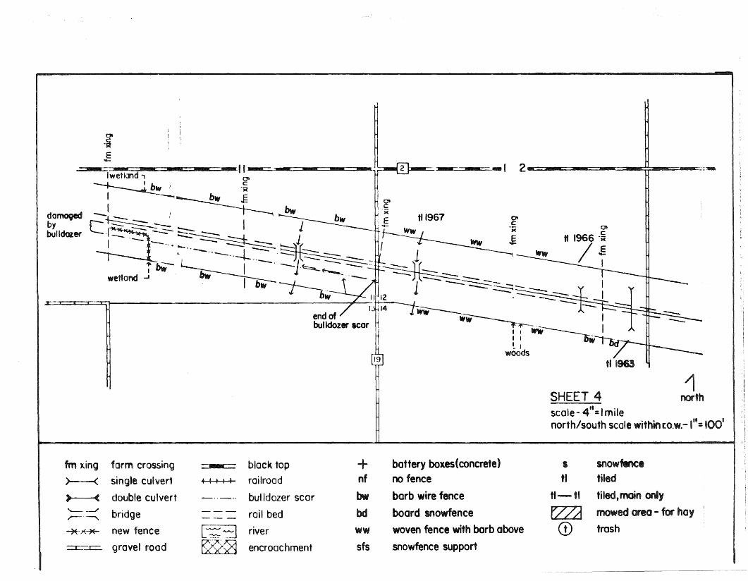
The cribbing snow fence was placed behind the permanent snowfence in the adjacent landowner's field. In some cases, only thecribbing snow fence was used. When the crib snow fence was takendown in the spring, the section crewmen would roll it up andplace it on pipe supports about two feet off the ground. Thesesupports can still be found with their fence rolls intact allalong the railroad right-of-way. The location of both typesof snow fencing as well as the snow fence supports is shown infigure
7)
Before leaving the matter of fencing, it should be noted thatnearly all the fences along this 8.5 mile stretch are in verybad repair. Apparently when the railroad began running intofinancial difficulty, the repair of fences was a low priority.Only in a few spots was the fencing in good repair. These spotswere generally areas which were recently grazed, such as pasturesadjacent to the right-of-way. According to some of the landowners,the section crewmen would put up fencing if it was absolutelyneeded. In a few cases, local farmers gave up and did their o~.,n
fence repairing.
For a key to the different kinds of fences still remaining alongthe abandoned right-of-way, see figure Several structuresoccur in the SNA, some dating to the railroad's origin. Theseare noted in figure also.
Probably the most obvious structures in the SNA are trestlebridges. Apparently many of these bridges have been repairedor rebuilt since the time of the railroad's origin. In some cases

8
the base of the creek or ditch over which the trestle passes, isriddled with the remnants of former log supports. One trestlebridge located in section 18 of Dexter township (most probably onthe Reiser land) was the cause of a railroad mishap. Reports state thatthe area received 15 inches of rain on June 20, 1874, resultingin the bridge partially washing out. A passenger train crossedthe bridge successfully but a freight train was not as lucky. Thebridge collapsed der1iling the train, injuring the engineer andkilling the fireman.
Other structures occurring in the SNA are culverts. Many of theseculverts date back to the origin of the railroad. Culverts made ofiron have been along this railroad since its building in 1870.More recent culverts were made of concrete and, in several spotssmall 3-4 feet trestle bridges take the place of cement or ironculverts.
One -_S-. P '0 t: '±. n 5, e" c 't ± 0 n , J. 8 con t a ins a ve rylarge, 6-foot wide concrete culvert. According to one railroad man,this large a culvert was used by cattle crossing from one side ofthe track to another.
Another type of structure occurring along the railway is the telegraph and, later, the telephone lines which ran along the northside of the right-of-way. This line service was used specificallythe by railroad and is evidenced by the downed electrical postsfound along the entire length of the SNA. These lines were inservice until approximately 1975, at which time the railroad switchedto the public telephone system. All of the electrical posts weresawed down at this time, the better posts being salvaged and shippedto other locations. The posts of less value were left lying in theright-of-way; T-bars can still be found with glass insulators from1945 and a few rare ones even dating back to the l870s. Here andthere telegraph wire can still be found draped over young oaktrees 20 feet high.
In spots adjacent to the railway bed, round or square cement boxesor tubs can be found. These tubs used to house the batteries whichran the railway signs. Curiously, in later years, public electricitywas used as a back-up system in case of battery failure.
The last structure in great evidence along this 8.5 mile-long SNA arefieldroads. Because the railway in many cases divided a farmer'sland, it was the responsibility of the railroad to maintain fieldroads that would enable the farmer to cross the railroad to his landon the opposite side. Many of these fieldroads have been inexistence for years, while others are more recent. The fieldroadsare noted on Fig.
Today most of the fieldroads are merely grass lanes or dirt roadsreinforced with a little gravel. In the past, however, each field-
1 , t ' 1 't fMC t M' tInterstate H1S or1ca Company, H1S ory 0 ower oun y, 1nneso a(Mankato, Minnesota: The Free Press Publishing House, 1884) p. 381.

9
road was reinforced with wooden rails placed in the ground, muchlike railway crossings over gravel roads.
Railroad Management of Right-of-Way
The land use history of the Wild Indigo would be incomplete withoutlooking at the railroad management of the area. Since the railroadwas built in 1870, only 14 years after most of this area was populated,it has been by far the largest reason for the SNA's present condition.
One of the management practices on this entire length of SNA wasburning. This was carried on during the 1800s and well into the1900s until approximately 1969 at which time burning of the right-ofway was banned. Generally, the burns would take place in the fall,after farmers had removed their crops. The primary function ofburning was to remove dead grasses and brush so that snow wouldn'tget caught in them during the winter.
Much of the right-of-way was also mowed on occasion. Some areasof weed infestations were handmowed with scythes even in the 1950s.Otherwise, during the 1950s - 1960s the Milwaukee Road used trackmowers, which would cut a swath 4 feet wide on each side of the track.On the return trip the mower would use extensions which would cutfrom 4 to 8 feet out from the track. In other words, during thetime period mentioned, 8 feet on each side of the track was mowed.
The railroad bed was given special attention. It was usuallynecessary to get rid of any plants that would fall over onto thetracks and cause the train wheels to slip or spin. As a result,a number of weed removal methods were tried. During the early1950s, the railroad bed was mowed, then in the latter part of the1950s the engines would stearn the track bed. Apparently, this wouldwilt the weeds for a number of days and then they would re-stearnthe area. In the early 1960s the section crewmen used fuel oilmixed with creosote on the track bed. This worked quite well forthem, but because of its flamability, accidental fire incidenceincreased, and the railroad quit using it.
From approximately 1957-1972 herbicides were used to help controlnoxious weeds. The chemicals 2, 4, 5-DT and 2,4-D were mentioned.Noxious weeds were those listed by the state, including leafy spurgeand thistle. For a few years during the 1960s, 2,4-D was mixedwith diesel fuel and applied to broadleaves.
Railroad section crewmen would also cut a lot of brush and trees,which is evidenced by the large amount of secondary tree growth(sprouting) found along the entire length of the SNA. In thelatter years (1970s), this tree trimming was done during the wintermonths. Hence, many were sawed off at least I' to 2' above ground.In all cases, timber was left to rot along the right-of-way.

10
Land Husbandry Practices
Second only to the railroad management practices in its effect onthe right-of-way, was the husbandry practices carried on by theadjacent landowners. Because all of the land next to the railroadright-of-way is farm land (except where the track runs through towns) ,farmland practices also affected the right-of-way. Four of thesefarmland practices will be examined: mowing, ditching, crop spraying,and tiling •.
Mowing - Very little mowing by local farmers was done on the actualright-of-way. However, two landowners did mention this being done.Howard Riles noted that his father during 1920-22 would use ahorse-drawn sickle bar to cut hay off the right-of-way in areaswhere it was level enough (see Fig. ). Another adjacent landowner,Arthur Pater, noted that his neighbor would mow the right-of-wayeast of the county road, cross over the tracks on his fieldroad,and then mow' the opposi te side of the tracks going west. (E~
Sec 15 TI03N RI6W). This was done during the years of 1946-51using a horse-drawn sickle bar also.
Ditching - As a method of crop land drainage, some of the areasnext to or running through t~e SNA have had ditches dug throughthem. In most cases the ditches were originally creeks that weredug to increase their runoff capacity. The ditch most recently dug,follows Wolf Creek and was backhoed in the fall of 1981. It runsthrough the lands of five different owners found primarily insection 18 and 17 of Red Rock township (TI03N R17W). The ditchrunning through section 11 of Red Rock township was dug approximately15-20 years ago and was "cleaned" out again in 1980.
Spraying - Since the Wild Indigo SNA runs through crop land, itwould seem improbable that this land has not seen herbicide orinsecticide spraying. In fact, only one person along this 8.5mile area stated that he did not use herbicide. All the restindicated the use of a number of chemicals: Lasso, Treflan, Bassagran,Sutan, Atrazine, 2,4-0, Lourox, Ami ben , Dual, and Atrex. Very fewindicated use of insecticides, except if they were forced to plantcorn on corn two years in a row, or in the case of an insectinfestation such as corn root worm.
Most chemicals are applied via tractor and sprayer, but in wetyears use of airplane-applied chemicals is stepped up. This isalso the case with the larger landowners who rely on airplaneapplied chemicals much more so than the smaller farmer who hasless acreage.
Spraying both ground-applied or air-applied may be the single mostthreatening factor to this SNA's existence. Because the wholewidth of this railroad is only 100 feet, a small amount of .herbicide drift could easily wipe out a whole cross section ofthe abandoned right-of-way. Moreover, because this area also doesquite a bit of crop production for canning factories (peas andsweet corn mainly), the threat of drift from aerial sprayingposes even more of a problem.

11
Even though it is hard to determine where spray drift has causedproblems it does seem highly likely that in some areas, edges ofthe right-of-way seem disturbed, while immediately adjacent to theseareas is good prairie. In certain places the edges of the right-ofway have brome growing in a scalloped-edge manner:
Brome
Fence Line
Railway Bed
Such a pattern frequently indicates a herbicide drift caused whenthe tractor and sprayer makes a turn at the end of a field.
Several adjacent landowners also stated that they would purposelyspray the fence line bordering the right-of-way in an attempt toget rid of ragweed and so forth. They felt that this kept the weedproblem farther from their cropfields.
Tiling - Much of the area adjacent to the right-of-way has eitherbeen tiled already or, as many landowners have indicated, will betiled within the next few years. Tile begins taking effect immediately, but its full potential is not felt for two years. As aresult, any vegetation in areas which have been tiled in an excessof 2 - 5 years should already have adjusted to the lower soilmoisture. Areas where the adjacent land has been quite recentlytiled should be monitored to see if there is a loss of some prairiespecies.
Railroad Abandonment to Present
The Milwaukee Road between LaCrosse, Wisconsin, and Austin, Minnesotawas barely used during its final years. As a result, this line wasabandoned in 1979, and the state purchased it the following year.On October 7, 1980, it was designated as a Scientific and NaturalArea.
During the summer of 1981 salvage crews in the process of removingrailroad ties from the railbed destroyed twelve acres of the SNA bybulldozing a road on the south side of the right-of-way from Austinto just east of Brownsdale. Even though the DNR began restoringthis area almost immediately, the scar will be seen for many yearsto come.
During the spring and summer of 1982 the DNR did some mowing ofsweet clover and ragweed, especially along the scarred area. Early

attempts at spring burning were destroyed by the monsoon weatherthat prevailed during the spring of 1982.
12

13
BIBLIOGRAPHY
Curtis-Wedge, Franklin, ed., History of Mower County, Minnesota,Chicago: H.C. Cooper, Jr. and Co., 1911.
Fedkenheuer, A.W. 1975. Past and present forest c9mmunities ofSt. Croix State Park, MN and their use in determining ecomanagement direction. Ph.D. thesis, Univ. of Minn., St. Paul (Forestry)
Interstate Historical Co., History of Mower County, Minnesota, Mankato,Minnesota: The Free Press Publishing House, 1884.
Original government survey data and maps, Secretary of State'sOffice, St. Paul, Minnesota.
Prosser, Richard, Rails to the Northstar, Minneapolis, Minnesota:Dillion Press, 1966.

---
LAND USE HISTORY
FIG.2
1SHEET I northscale - 4"· I mile I..north/south scale within r.o.w.-I == 100
~
: >-:.2.
IH3
"161
·sE-
• ~ -==--tt--;' ··----~~'6
woodhoven
12
fm xing form crossing .. black top
>---< single culvert • I I I railroad
»---( double cufvert _.._ .. bulldozed scar'------/ bridge --- rail bed~ ---xxx new fence g river
:c.:r=:r:: gravel road ~ encroachment
+nf
bwbdwwsfs
battery boles (concrete)no fence
barb wlre fenceboard snowfence
woven fence with barb above
snowfence support
I
tl
tI-tl
~CD
snowfence
tiled
tiled,main onlymowed area-for hay
trash

--~
:::::::-~age by
~
woven fence with barbabove
Inowfence support
snowfencetiled
tiled,main only
mowed area - for hoy
trash
ww
sflI
tl
tl-tl
t?LZ1CD
1north
SHEET 2scale - 4": Imilenorth/south scale within [o.w.-''': '00'
form crossing
single culvert
double culvert
bridge
new fence
gravel road
black top
railroad
bulldozer SCQr
roil bed
river
encroachment
battery boxes(concretel
no fence
barb wire fence
board snowfence
xxx
fm xing
, ,/
) (
) <
I~~I
~+nf
bw
bd
(fOOdy\encerow .[
r--)~..r::=:r;: .E ~~ __ .. _-Y__~ I
"!lIt wet I 'I ' r 1 ......~ I --: : 'L~: --::a~A/I~ w--t--;::::::y.....-I.·,....··...-··
, _~ __ I~~
...--..O.,____ __ .. .--" I ., I.....-:: _____,..,,.. .- I.....-:: ::::::-::. ..J- .. __ .. -1 '-.A I
--0 ___,..' V'" l-;:::.... . . .. I 1-
1
/- t~ power__ .. __ .1---+-- I slotI
______-... 'I . I. ..-____ ,...... L I( I
____~ tiled wetlond\ ..J1981 I "17 woody
fencer()w
. ?'1~~
g-OJ;(
E'- -,I
r ~rassland
Iatl.~ IE: ~...........-- I J ~.......-
i Il~sis---M~..:>1 ..-:-----::.:-- ::r-' .y . ..........----
~..::-- .- .r·... · I .......-+ tA "
~::..--- ....-' /1~ I-.....- ."'- I
..",.,.' . I Il -'wetland
_ 18 J0!19 19120
II
Ii
J
~ . - '-.:::'-:-::

damaged bybulldozer
form crossing + battery boxes (concrete)
single culvert nf no fence
double culvert bw barb wire fencebridge bd board snowfene
new fence ww woven fence with barbgravel rood
above
sfs Inowfence supportblack top
railroads snowfencl
bulldozer scartl tiled
roil bed '1-'1 ti led 11 main only
river bed lZ/ZJ mowed area-for hay
CD trashencroachment
C'c:'xc I
enc
=':'rwet -~ 100d ~_.:::=-::::.
t ~:T
--II ...
f--+-+-i
xxx
=c---:::t::=
, ,, ~~.~
fm xing
) (
1~3
~
• c
\56
~
9
1north
SHEET 3scale-411
: I milenorth/south scale within r.o.w.-I"=IOO'
01 woods~ r 1E rfield...J I- I I I
r Woods ., I! ~I I I I
: I I,II~wetland __
I..... ', :> 1: - - . w-: - t=:.:: .:x::..--t·_- ::r.:..=x:.::..: 1 ...=.:1 __ r" .,.... ..,- il I
_ 4 4~3h 119 9i
~BROWNSDALE
IIII'Ii
'"'-.'71r . -- ..... --~~ ~ {2 i - :::...:-.
rdevelopmlnt
: l~ 11
I!_-
Otc
tI 1966 OK
/~I
2 - :: __=_.::"1IIIIa
0'c
OJ;(
.E
-I
tl1967
0-ojE- JII ----===-IIIIII::=:::::J-=-IIIIIILo--.,-""~=-~~:::::::BII~IIIII8IIIC:::~ g' '"
~~~~iI I I 1~----~~ 1 '1r- :...-,::.~ ::::.;: __~~ __ ~Wl~- . -- --=-l-- .- - - ~c:: -.::::-- ---===-= __- - ..• ~ .._.. :1 <- __ __ --.; __
I • -" "-, --r----._.. ._ 1- L.-..- j-'-'-k jibIW. btr~ J b~ 1112weiland ... r '14
damagedbybulldozer
1SHEET 4 northscole- 4": Imilenorth/south scale withinto.w.-Iu
: 100·
1m )\ing farm crossing black top
>--< single culvert • I I I I railroad
)I ( double culvert _.. _-- bulldozer scar'-- _-/ bridge --- rail bedr--'~ ---~.J(""*"" new fence [~~ river=:I:::=..c::. grovel rood ~~ encroachment
+ battery boxes(concrete) s snowfenclnf no fence tl tiled
bw barb wire fence tl-tl tiled,moin only
bd board snowfence t2Z1 mowed area - for hoy
ww woven fence with barb above CD trash
sfs snowfence support

-=::::&Eiii;', t 7 -.., .~ 8 ._~
-==c.:. ' , 8 IJ
0-.l; 0)( C
'x.E E,
I
18
tl outlet
0COw
woodsIwet~. .Ei II 7 8
IB'~~WWI sfs: . s/sfsI ss
1---=:w...::::::::-- --- --'-- -- ft'-.- ~------..:::==-=:::_~~~-- - - - - - - - - - - ...::::---:::::
1weI JJ l¥W-~-bwln;-"11
north17 SHEET!2 ,
"-Imile -1"=100scale-4
-h scole within r.O.w.north/sout
fmxing form crossing black top) < si:1gle culvert • I I I • railroad) ( d0uble culvert ......... _-.. bulldozer scar'---..J bridge --- rail bed.r---"'. ---"*** new fence ~3 river
gravel rood ~ encroachment
+ battery boxes (concrete) I .,owfencenf no fence tl tiled
bw barb wire fence tl-tl tiled.main onlybd board snowfence ~ mowed cna-for hay
ww woven fence with barb above CD trash
sfs snowfence support

atc.;;c
9 H1016 U 15
(/)(/)
It:
L
'-
'0--0
:?')1
.E
~:-:::=:~ - -AIf --A~-=t=
".------.._-" 1981 bw
~-==-~:~ \: 9 ==--.-...... ==-::=:BIIIIIIl.!~ -..... '-·--10 .- 12 ~ I •
SHEET 6scale- 4
1
':: Imilenorth/sooth scG:a withen ro.w. -I"=100'
fm xing form crossing :..:..~ block top
> ( single culvert -t-t t-+- railroad
• ( double culvert - >._-'.- bulldozer scar'-_---/
bridge ------ roil bed,.~ - ----7f.*:*- new fence [~~ river
-~~
:--r--y-- grovel rood FZ29 encroachment
+ battery boxes (concrete) s snowfenceIInf no fence tl tiled 1.1
bw barb wire fence tiled,main only~I
tl-tl 1,1·1
bd board snowfence fZ7Lj mowed area -for hoy[,1
I
ww woven fence with barb above CD trash
Ifs snowfence support

I • • • "fr~, , I , ===r ' I , , I , 8 i i l!...L - -14 r13 ' " r T • • • • • =r=: r==r =r==r= • .:
~.2.
j
10'C
"i(
13
I
--~--i_t_.- -- --------::::::.~II.'- --------
DEXITER14
0".sJo(
E II 1978-~'!-- --- --!1 ______I
~I-- -- -- --._-- ~T:q:-:.:~- --==-:c: -.:::.::~-:::::=- --2:=~~I -'rn-rc,O(i- _
wW--4- w..;- -----",--- -- -nr--- r----;-L- wet-J
1.",-'-T--i • « • ".. • • :c:..:.:c-.:..z::.:... I ..:.:.r_: ..g i
SHEET 7~cQle -4"=lmile 1north/south scole within r.o.w.-'"=100' north
fmxin9 form crossirlQ black top
) < single culvert , , I I I railroad
) ( double culvert _.'- .. bulldozer scar'-----/ bridge --- rail bedr---.. ---~ new fence L-=.~ river
gravel road ~ encroachment
+nf
bw
bd
wwsfs
battery boxes (concrete)
no fence
barb wire fence
board snowfence
woven fence with barb abovesnowfence support
I
II
tl-tl
EZZJCD
snowfencetiled
tiled,main only
mowed area -for .hay
trash

21
GEOMORPHOLOGY AND SOILS*
The landforms of this part of ~he state may conveniently be subdivided into two major regions:
1) An area of younger glacial drift of probaly mid-Wisconsinage, and
2) An area of older glacial drift.
The younger drift area for the most part was covered by ice ofthe Des Moines lobeMwhich advanced through Minnesota from thenorthwest into Iowa'over 14,000 years ago. This area consistslargely of constructional glacial landforms~many of which havebeen scarcely eroded, or even mildly gulliea.
A greater variety of landforms exists within the area covered bythe Des Moines lobe than in the old drift area where the surfacehas been lowered and dissected by streams and mass-wasting processesand smoothed out by the deposition of wind-borne loess. The extremesoutheastern part of the older drift area in parts of Houston andWinona Counties seems to be largely free of glacial drift. It isconsidered part of the Driftless Area which extends into southwestern Wisconsin, northwestern Illinois, and northeastern Iowa.
Possibly an almost universal feature of the nearly level surfacesof the old drift area is the cover of windblown silt or loess)which thickens towards the east. It is probably not older thanthe Wisconsin, and it was derived from the Mississippi Valleytrain deposits as well as from local tributary outwash and valleytrain deposits.
The age of the glacial drift in this older drift area has beendisputed, and probably drift of at least two ages is present. Mostof the surface has been developed on Kansan till from which theoriginal soil was removed and the newly eroded surface covered withloess. The lowering of the Kansan till surface so that itmaintained long gently sloping surfaces without excessive dissectionhas been explained by an appeal to pedimentation, a process oflandscape modification now largely restricted to arid and semi-aridregions. During pedimentation coarse sediments were depositedalong the major drainageways leading off the eroded Kansan surface.These deposits are mostly covered with a loess. Present-day soilsare formed in the loess but their properties are frequently greatlyinfluenced by the underlying material.
Fig. 3 delineates the geomorphic areas within Mower County asidentified in the Minnesota Soil Atlas, st. Paul sheet. Geomorphicareas illustrate broad physiographic features and provide someidentification as to the nature of parent materials on which thesoils have developed. The geomorphic areas that Wild Indigo SNAtransects are described in the following paragr~phs.
*Summarized from Misc. Report 120-1973 Minnesota Soil Atlas, St. Paulsheet, Agricultural Experiment Stn., Univ. of Minn.

Younoer 1(,):
Drift Area
dodge
wabasha
olmsted
*Iraane prairiesna
mower I fillmore
winona
Older Drift Area
houston rfI"
Fioure 3
Major Landform Regions of Southeastern Minnesota(adapted from misc. report 120-1973. minnesota soil atlas, sf. paul sheetJ agriculture experiment stationuniversity of minnesota)
'.r

'II
~
~f;(
~
ii~~,t~
;;Ii~
"
adams
Figure 4
Geomorphic Regions of Mower County
iI
Legend of GeomorphicAreas I JI ,\_ "
..,......'" • • '--' ............... ~I ~,,","" " • ,. '. m~racine prOlrItJ-I .:1
31 cedar valley out- ~ ~" If I(~ \ q> / scientific 8 .
wash natural areaI
jI 36 northfield/myrtle. I
I moraine, silty,gentlyj rolling11 I 37 claremont/lyle I
I -- I I~::·:I· oJ' J/Jr.. ", ~ ¥ '7:'1: __....meodow~16
i
plain, silty, level
38 kenyon/taopi plain,silty, undulating I, ~- (aUSTIn I ( \ 38
i.!

Cedar Valley Outwash (31)
The Cedar Valley Outwash consists of nearly level outwash plains,terraces, and bottomlands along the headwater tributaries of theCedar River. The water table is normally deeper than 10 feet onthe outwash and terracesj' but is less than ,3-'feet from the -.s.llr£.aceover one-third of- the-~rea. ' The bottomland water table occursbetween the surface and a depth of 6 feet.
Most of the soils on the terraces and outwash range from loamy sandto loam or silt loam less than 36 inches thick over sand and gravel.The water-holding capacity ranges from low to moderate. Bottomlandsoils are subject to frequent flooding. Most are loam or siltloam in texture.
The original vegetation on the terraces and outwash was dominantlyprairie grass with occasional oak clumps. Bottomland hardwoodsconsisting of elm, ash, cottonwood, boxelder, basswood, soft maple,willow, and hackberry were the original cover. The terraces andoutwash are cropped with corn, soybeans, oats, and alfalfa-bromehay. Peat areas are cropped to potatoes. Bottomlands have about25% corn and the rest, pasture of woodland.
Northfield-Myrtle Moraine: Silty, Gently Rolling (36)
The Northfield-Myrtle Moraine consists of a gently rolling siltmantled and moraine. The dominant landform is a complex of knollsirregularly emplaced on a regional slope. Slope irregularity hasbeen subdued by a silt mantle. Closed depressions are common.Contour lines have a very erratic pattern.
Water tables on the knolls are more than 10 feet deep. The watertables on the lower levels are from 1 to 6 feet deep. Three smalllakes occur in this region. Old lakebeds and depressions are filledwith peat.
24
Original vegetation consisted of tall prairie grass with someaspen-oak land and oak openings scattered over the region. Wetsoils and peat were covered by sedge grass. Present crops arecorn, soybeans, alfalfa-brome hay, oats, and wheat. Less than 5percent of this region is pastured and less than 5 percent, woodland.
Claremont-Lyle Plain: Silty, Level (37)
The Claremont-Lyle Plain consists of a nearly level silt mantledtill plain. The dominant landform is one of very gently undulatingto nearly level plain. The few highs are 5 to 15 feet above thelow landforms. Bedrock is within 5 feet in a few places.
Water tables in this region range from the surface to 6 feet deepseasonally. No lakes occur in the region. Some small depressionshave a thin coating of peat or muck but not large enough to recordon the map.

25
Original vegetation consisted of tall prairie grass and sedgeswith an oak brush cover on the slightly elevated areas. Presentcrops are corn, soybeans, oats, wheat, timothy, clover, hay andalfalfa-brome hay. Approximately 10 to 15% of this region ispasture. Less than 1 percent is woodland.
Major soil ser~es occurr~ng on the 8NA w~th~n the Claremont-LylePlain geomorphic region
Clyde silty clay: Dark-colored, poorly to very poorly drainedsilty clay loams about 40 inches thick over heavy loam tillwhich is calcareous. at about 5 feet (Typic Haplaquoll). Nearlylevel to depressional upland.
Sargent silt loam: Light-colored, somewhat poorly drained, stronglyacid silt loam about 20 inches thick over medium acid clayloam about 26 inches thick over clay loam glacial till (TypicGlossaqualf). Nearly level to undulating upland.
Tripoli silty clay: Dark colored, poorly drained silty clayloams about 20 inches thick over loam glacial till (TypicHaplaquoll). Nearly level uplands.
Hayfield loam: Moderately dark colored, moderately well to somewhatpoorly drained loams formed in glacial outwash underlain bysand and gravel (Aquollic Hapludalfs). Nearly level to depressional upland.
Udolpho silt loam: Moderately dark-colored, somewhat poorlydrained, slightly to medium acid silt loam about 18 inchesthick over strongly acid loam about 12 inches thick gradingto slightly acid sand about 12 inches thick over calcareoussand and gravel (Mollie Ochraqualfs). Gently sloping upland.
Kenyon-Taopi Plain: Silty, Undulating (38)
The Kenyon-Taopi Plain consists of a sloping silt mantled erodedtill plain. The dominant landform is one of long swell and swalerelief with highs from 20 to 80 feet above the lows. Slopes arelong, 250 to 1,000 feet.
Water tables vary from 1 to 10 feet deep, seasonally. Depressionsare few and nonexistent over much of the area. The drainage netis a well-established dendritic type, but few streams beyond themain trunks have incised the silty mantle. No lakes occur in thisregion.
Original vegetation consisted of tall prairie grass on the west andsouth. On the east, aspen-oak land occurred, consisting of smalldense stands of aspen and scattered oaks. Present crops are
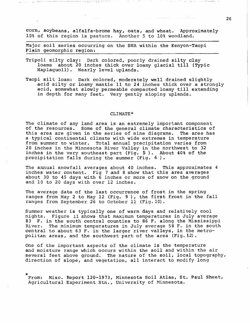
corn, soybeans, alfalfa-brome hay, oats, and wheat. Approximately10% of this region is pasture. Another 5 to 10% woodland.
~ajor soil series occurring on the SNA within the Kenyon-TaopiPlain geomorphic region:
Tripoli silty clay: Dark colored, poorly drained silty clayloams about 20 inches thick over loamy glacial till (TypicHaplaquoll). Nearly level uplands.
Taopi silt loam: Dark colored, moderately well drained slightlyacid silty or loamy mantle 11 to 24 inches thick over a stronglyacid, somewhat slowly permeable compacted loamy till extendingin depth for many feet. Very gently sloping uplands.
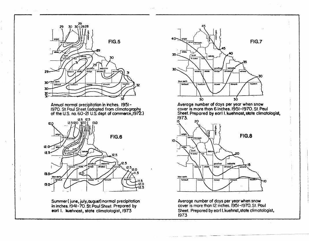
CLIMATE *The climate of any land area is an extremely important componentof the resources. Some of the general climate characteristics ofthis area are given in the series of nine diagrams. The area hasa typical continental climate with wide extremes in temperaturefrom summer to winter. Total annual precipitation varies from28 inches in the Minnesota River Valley in the northwest to 32inches in the very southeast part (Fig. 5). About 40% of theprecipitation falls during the summer (Fig. 6 ).
The annual snowfall averages about 40 inches. This approximates 4inches water content. Fig 7 and 8 show that this area averagesabout 30 to 45 days with 6 inches or more of snow on the groundand 10 to 20 days with over 12 inches.
The average date of the last occurrence of frost in the springranges from May 2 to May 12 (Fig. 9 ), the first frost in the fallranges from September 26 to October 11 (Fig. 10).
Summer weather is typically one of warm days and relatively coolnights. Figure 11 shows that maximum temperatures in July average83 F. in the south central counties to 86 F. along the MississippiRiver. The minimum temperatures in July average 58 F. in the southcentral to about 63 F. in the larger river valleys, in the metropolitan areas, and the southwest part of the area (Fig. 12).
26
One of the important aspects of the climate is the temperatureand moisture range which occurs within the soil and within the airseveral feet above ground. The nature of the soil, local topography,direction of slope, and vegetation, all interact to modify long
'* From: Misc. Report 120-1973, Minnesota Soil Atlas, St. Paul Sheet,Agricultural Experiment Stn., University of Minnesota.
term air temperature averages. The southcentral part of the areais the coldest; however, to date meteorologists cannot answerwhy. Agronomists are also aware of this cold area since earlymaturity soybeans. are the most successful.
27
"10
FIG.7
FIG.8
faribaUtblue earttI
30 30
Average number of days per year when snowcover is more than 6 inches. 1951-1970.Sf. PoutSheet. Prepared by earl I. kuehnast. state climatologist,1973.15 20
35
.10
40 3. .... ~i I
32
FIG.6
FIG.5
11.512.0
-----......'2.5
2929 30 30 l2828
Annual normal precipitation in inches. 1951-1970. Sf. Paul Sheet. {adopted from climotogrophyof the U.S. nO.60-21 U.s. dept. of commerce,I972.}
12.5 12.512.512.0 \12.0' 13.0
r7l~J
Jl.. J. =j:...."e""':! r:---- ~(I I '
B.
Summer( junl, july,august) normal precipitationminches. 1941-70. Sf. Paul Sheet. Prepared bytort I. kuthnost, statl climatologist, 1973
Average number of days per year when snowcover is more than 12 inches. 1951-1970. Sf. PaulSheet. Prepared by earl I. kuehnst,state climatologist,1973

FIG.12
FIG.11
84
faribalAlblue earth
~~ \85 M 83 0';;» - • 85
Average daily maximum temperature during July.1951-1970. Sf. Paul Sheet.(adapted from dimato-~7~{ of the U.S.. no.60-21. U.s. dept. of commerce,
616Z63 ~
Average daily minimum temperature during July.1951-1970. St. Paul Sheet. (adapted. from chmatography of the U.S. no. 60-21. U.S. dept. of commerce,1972.)
FIG.10
FIG.9
fillmore
filllT10lSmowerfreebornIarbauIt
Id/6 10YI - - - r. 10/1'Ib/6
Aver098 date of first occurrence of 32° forIO'Ner In the fall. St. Paul Sheet. (adapted fromminn. tech. bull. 243, 1963.)
5/7 5/15/2
Aver0ge date of last occurrence of 32° Forlower In the spring. Sf. Paul Sheet. (adaptedfrom minn. tech. bull. 243, 1963.)
Q'I, --
IQlI
'!J11. c:: ::z """'--

VEGETATION
Introduction
Wild Indigo Prairie is a good example of a distinctive type of tall grassprairie which in Minnesota is confined to the southeastern portion ofthe state. In SE MN. at the time of settlement. the tallgrass prairie andthe closely related oak savanna were the dominant vegetation featureson the landscape. Tall grass prairie found on deep. nutrient rich,silt-loam soils was once continuous over thousands of square miles(see Fig. ). Today, as a result of destruction of the prairiethrough cultivation the continuous tall grass prairie is gone.According to the Minnesota Natural Heritage Program (NHP), whichmaintains a comprehensive data base on sensitive biotic communitiesand species, less than 500 acres of intact (SE MN) Tall Grass Prairieexists in the region. Railroad right-of-ways are now the only significantareas in SE Minnesota where virgin tall grass prairie can still befound. The NHP considers this tall grass prairie type to be threatenedthroughout its entire range and critically endangered in Minnesota.
The (SE MN) Tall Grass Prairie exhibits greater species diversity thanany other prairie community type in Minnesota. The flora shows a strongaffinity to the south and east. and contains species which in Minnesotaare either restricted to or modal to the southeastern portion of the state,including prairie wild indigo Ba tisia leucophaea,) wild indigo (Baptisialeucantha), Rattlesnake master Er n ium uccifolium), wild quinineParthenlum inte rifolium), Indian plantain Cacalia tuberosa), CowbaneOx olis rigidior , and Cream gentian (Gentiana flavida).
The Wild Indigo SNA contains several vegetation types including uplandtall grass prairie (wet-mesic. mesic and dry-mesic) lowland tall grass(wet) prairie, open woodland, reed canary grass meadow, and severelydisturbed old field. Along the entire 12 mile length of Wild Indigo SNAare found segments of relatively undisturbed (SE MN) Tall Grass Prairierepresentative of native presettlement conditions•. Interspersed withundisturbed prairie are vegetational assembleges which reflect variousdegrees of disturbance. Drift of herbicides from crop spraying, soildisturbance from construction and maintenance of the railbed, siltationfrom upland erosion of adjacent cropland, and cultivation of the rightof-way are some of the disturbances which have altered the originalvegetation. The degree of alteration is largely dependent upon theseverity of disturbance. Severely disturbed areas may exhibit acomplete replacement of the original prairie components by weedyEurasian species. Confinement of the prairie to the narrow fifty footright-of-way between the railroad bed and adjacent cropland makes thetract especially susceptible to degradation. Even small scale soildisturbances, such as animal burrowing, appear large relative to thesize of unit. Such disturbances can significantly alter the speciescomposition of a segment of the prairie and create conditions unfavorablefor the survival and propagation of the "climax" species, especiallythose with narrow ecological tolerances which r~quire more stableconditions.
30

·c
FI "1 L s",
Extent of (SE liN)
the time of settlement
.Tallgrass Prairie at
I'LOLlI,
.lIIeWIOWlOCI(
IIIICOlli lVO_It !Lll!!.~~
1 .......e~e.~'",
.OLI(----
'!!r!p!-l"..------r--......_

[j wooded (W)
,~~.ow ,r.lr'e (l)!
trj upland prairie (A.B.e.or D)
[ill .everely dlaturbed (8D)
.•••••• '......................... .&.'&'" & ... -" ...
11IIDoo....u
< 80 feet
··t····.· .... "·1
.)JMN8?M?~IIIIIIIIII•II•".II,
-----.......).
...."
....• • •." .a ~::::t :::»0 III 0I:. .... .t::.11II II
Fig.14 Vegetation types occurring at Wild Indigo SNAA mapping unit is approx. 30 feet wide (A-A)and ~ mi long

33
The reintroduction of fire and implementation of appropriate managementtechniques is needed to mitigate disturbances and to begin restorationof the disturbed areas in the Wild Indigo SNA.
Methods
The vegetation at Wild Indigo SNA was inventoried in ~ mile mapping units.The north and south side of the rai1bed were treated separately. The mappingunits are in contiguous ~ mile units unless the unit is interrupted bya physical barrier such as a bridge or a road. In this event, the physicalbarrier was treated as a boundary, hence some mapping units may be longer orshorter than ~ mile. The vegetation on the ballast of the tracts and the ajacentshoulder or embankment was not mapped; however, a general description ofthese severely disturbed habitats is provided. Individual mapping unitsare approximately 30 feet in width and ~ mile in length, .
A classification system was devised to describe the vegetation of each~ mile mapping unit. According to this system, the vegetation at WildIndigo SNA was stratified into 8 types (see Fig.14). The classificationtypes were determined by soil moisture (i.e. upland or lowland), vegetationcomposition, and vegetation quality (as measured by degree of disturbance).
The purpose, in part, of this inventory was to document the significanceof Wild Indigo SNA as an example of the (SE MN) Tall Grass Prairie type. Anassessment of vegetation quality was made for each mapping unit containingupland prairie vegetation to achieve this purpose. Natural quality isdefined by the degree in which the original prairie vegetation has beenaltered. High quality prairie assembleges are those with littleor no evidence of disturbance, where species composition is intactand reflects native presettlement conditions. The following featureswere analyzed when evaluating prairie quality: 1) presence of characteristicprairie species; 2) presence of rare and conservative prairie species(i.e., those with n~rrow ecological tolerances, relatively restrictedto undisturbed, stable conditions); 3) distribution and diversity of nativeprairie species; 4) presence of exotic species; 5) abundance anddistribution of the ubiquitous native prairie species which tolerateor increase under disturbance.
At each ~ mile, the mapping unit was classified by the dominant vegetationtypes which covered 25% or more of the unit. When patches of differentvegetation types occurred within in the same mapping unit, a mixedclassification code was used. Mixed vegetation types are separatedby a slash (e.g., A/Re, with the dominant vegetation type listed first.)
The above classification system was initially developed by reviewing avariety of information sources available on the Wild Indigo area, includingvegetation maps, railroad right-of-ways surveys, and species frequency datacollected in summer 1982. Finally a field survey in November 1982 wasconducted to refine the classification scheme and to classify the vegetationof Wild Indigo SNA in each of the ~ mile mapping units.
In addition to the classification system a number system corresponding tomore detailed map explanations was utilized. The numbers are used primarilyto define areas where management problems may occur, and also to moreprecisely describe the vegetation. This information is on file at theMinnesota Natural Heritage Program.

34
Community Descriptions
High Quality Natural Prairie (Type A): dominates six mapping units, 6% ofthe ~ mile units.
This prairie type reflects native presettlement conditions; ahigh native species diversity, a lack of exotic or weedy species, and apresence of conservative species (e.g., those which typify and arerelatively restricted to stable, undisturbed conditions). This prairietype occurs in areas where the soil has not been disturbed. They arecharacteristically upland mesic type prairie (dry-mesic, mesic, wet-mesic)occurring on silt loam soils and are dominated by native grasses includingbig bluestem Ando 0 on gerardi), little bluestem Andro 0 on scoparius),Indian grass Sor hastrum nutans) and prairie dropseed S orobolus heterolepis).Characteristic prairie forbs include coreopsis (Coreopsis palmata , blazingstar Liatris cnostachia), pucoon (Lithospermum canescens), and goldenalexanders Zizia aurea. High quality prairie sites also exhibit anabundance of conservative prairie species such as cream wild indigo(Baptisia leucophaea), wild quinine (Parthenium intre rifolium), rattle-snake mast~Eryngium uccifolium), birdsfoot violet Viola pedatifida),leadplant (Amorpha canescens and white prairie clover Petalostemum candidum).Within these mesic type prairie areas there are occasionally small pocketsof wet prairie vegetation. These areas are typically less than 25% of amapping unit. The vegetation assembleges are diverse and include relativelyconservative wet prairie species such as valerian Valeriana edu1is),swamp saxifrage (Saxifraga enns 1vanica), cowbane Ox olis rigidior),prairie lily (Lillium superbum and prairie milkweed Ascle ias su11ivantia).
Good Quality Natural Prairie (Type B): dominates 17 mapping units, 16.5% of the~ mile units.
Natural prairie types similar in species composition to Type A sites, exceptsome of the more conservative species may be absent or the complement ofexpected prairie species is not fully represented. There may have beenlight soil disturbance in the past, but the vegetation now reflects relativelynatural conditions. This prairie type may contain small patches of weedy orpioneer species; these are often associated with the soil mounds producedby high populations of burrowing animals. The soils mounds, which are quitefrequent in many areas, are often invaded by exotic weeds from the adjacentagricultural fields, or by native pioneer plants. Suppression of fire hasprobably been an important factor in precluding the native "climax" speciesfrom reinvading these sites. Typical species which colonize fresh soilmounds include catchfly (Silene antirrhina), lesser ragweed Ambrosiaartemisifolium), field horsetail (Eguisetum arvense) and yarrow Achl leamillefolium). Abandoned eroded mounds are often dominated by aggressiveperennials such as quack grass (Agropyron repen~) and bluegrass (Poa prantens;s).
Disburbed Upland Prairie (Type C): dominates 31 mapping units, 30% of the~ mile units.
Disturbed prairie types are identified by their species composition whichno longer reflects virgin conditions, but has been altered by light tomoderate disturbance. The disturbed habitat has a low species diversity andis dominated by those native species which tolerate or increase with

35
moderate disturbance. Species composition is often incomplete. with certaincharacteristic species missing, and, typically, there is an absence of the moreconservative prairie species. These sites are often characterized bydense stands of ubiquitous native plants which are able to persist underdisturbed as well as stable conditions. The most prevalent species inthis habitat include, bergamot Monarda fistulosa), rigid goldenrod(SOli1ago ri ida), tall sunflower Helianthus grossessaratus), yellowconef ower Ratibida innata), yarrow Achillea millefolium), canada wildrye El us canadensis, big bluestem Andro 0 on gerardi), and heathaster Aster ericoides). Many of these sites are fairly good prairiewith litt e influence by exotic weeds. Other sites are more degradedand Eurasian weeds are found scattered throughout these areas in patches.The more degraded areas are typically old field communities with a largecomponent of blue grass (Poa~) and dense stands of asters (Aster ~)and goldenrods (Solidago ~).
Degraded Prairie (Type D): dominates 1 mapping unit, .9% of the ~ mile units.
These sites are artificially disturbed habitats where the natural prairievegetation has been significantly altered. Recent disturbance of the soilby grading, scraping, and compaction have resulted in a vegetationdominated by a disproportionate mix of native prairie species and annualand biennial weeds. Pioneer weed species typically dominate, these includelesser ragweed Ambrosia artemisifolia), bull thistle Cirsium vulgare),field bindweed Convulvulus sepium), foxtail Setaria glauca , sweet cloverMelilotus alba, prickly lettuce (Lactuca scariola) and red cloverTrifolium repens). Normally there are scattered clumps of native grasses
still present throughout these areas, notably big bluestem Andro 0 on gerardi).Native prairie forbs are rare, they include rigid goldenrod Solida 0rigida) and yellow coneflower (Ratibida pinnata).
The degraded prairie type is confined to areas of recent disturbancesuch as right-of-way areas encroached on by farm vehicles. Another areais a twelve acre strip of prairie which was severely disturbed in 1981when bulldozed road along the south side of the right-of-way was put infrom Austin to Brownsdale to assist in removal of railroad ties. Withremoval of disturbance and proper management, these areas are expectedto succeed toward replacement of weedy vegetation by native prairiegrasses and forbs.
Lowland Prairie (Type L): dominates 19 mapping units, 18.5% of the ~ mile units.
The lowland prairie type occupies the somewhat poorly and very poorlydrained soils found throughout the tract in low lying areas. These sitesfrequently have standing water after heavy rains and following springsnow melt. Lowland prairie is dominated by wet prairie grasses,bluejoint grass (Calamagrostis candensis), and cordgrass (Spartina pectinata).This prairie type has a much lower floristic richness than the adjacenthigh quality upland prairie sites (Type A and B). The lowland prairie isoften a monotypic stand of wet prairie grasses with little forb diversity.The most prevLlent prairie forbs include tall sunflower {Helianthusrrossessaratus). marsh goldenrod (Solidago gigantea) and New England aster_Aster novae-argliae). These areas commonly grade into sedge meadowwhich are dominated by sedges including Carex sartwell ii, C. bauxbaumii,~ lanuginosa, and ~ haydenii. --

36
In terms of natural vegetation quality the lowland pralrle type is similar tothe upland prairie Type C (Disturbed Prairie). Both these prairie types exhibita relatively low species diversity. The lowland prairie type typically lacks thepresence of exotic species; however, as the wet conditions are more favorablefor invasion and dominance by native species. The low species diversitymay be the result of disturbance from ditching and alteration of drainagepatterns and also by herbicide damage. Severely disturbed lowland areasare often dominated by solid stands of reed canary grass Phalaris arundinacea);this vegetation type is classified separately (see Type RC •
Wooded Areas (Type W): dominates 11 mapping units, 10.5% of the ~ mile units.
This habitat type is dominated by woody vegetation. The low-lying areasscattered throughout Wild Indigo SNA are occasionally colonized by treesand shrubs. Thickets of willow (Salix bebbiana, ~ gracilis and~. rigida)occur in low prairie areas; the understory characterized by wet prairiegrasses such as Spartina pectinata, Calamagrostis canadensis, and byexotic species Phalaris arundinacea and Agrostis alba. Other low areasare colonized by trees such as trembling aspen (Populus tremuloides) withlesser amounts of box elder (Acer negundo) , and bur oak ~ercus macrocarpa).The understory is typically very species poor, often dominated by uniformstands of several species. Upland areas are occasionally dominated by buroak uercus macrocarpa) with grey dogwood (Cornus racemosa), Americanhazel Cor lus americana), wild plum (Prunus americana), smooth sumac(Rhus glabra , and blackberry (Rubus alleghen;ensis). The understoryis most often old field dominated by Eurasian weeds such as bluegrass(foa ~), and quack grass Agro ron repens), and dense stands of nativeo d fleld species such as goldenrod Salida 0 canadensis). Trees growingalong fence rows adjacent to agricultural fields are providing the seedsource for woody invasion of the right-of-way in a number of areas.
Reed Canary Grass Meadow (Type RC): dominates 6 mapping units, 6% ofthe ~ mile units.
Moist degraded habitats dominated by nearly solid stands of reed canary grass(Phalaris arundinacea) can be found scattered throughout Wild Indigo SNA.Reed canary grass commonly invades severely disturbed low lying areas. Thisvegetation type is often found along areas which were ditched and in areaswhere there is heavy siltation resulting from erosion off adjacent farm fields.
Severely Disturbed Community (Type SO): dominates 12 mapping units, 11.5%of the ~ mile units.
This habitat type is characterized by destruction of the original vegetationand replacement by old field weeds. The vegetation is dominated by aggressivesod forming Eurasian grasses including bluegrasses (Poa ~), timothy(Phleum pratense), quack grass A ro ron repens), foxtail (Setaria glauca),redtop (Agrostis alba), and field brome Bromus inennis), with old fieldforbs such as hoary alyssum (Berteroa incana , common milkweed Ascle iassyriaca), horse weed (Conyza canadensis), sweet clover (Melilotus alba, andwild parsnip (Pastinaca sativa).
This habitat type commonly occurs where severe soil disturbance and
herbicide damage has taken place. Drifting of herbicide from cropspraying is often evident along cropland edges» where solid sods offield brome often occur. The severely disturbed community also appliesto the shoulder area adjacent to the railbed. where cut and fill andgrading during construction of the tract has significantly altered thesoil. The shoulder area is typically five feet in width and bordersboth sides of the railbed. On a number of segments of the railroad theshoulder becomes a steep embankment. In this event the shoulder areabecomes quite wide and takes up most of the rightofway; there is littleor no native prairie in these areas. Perhaps the most altered environmentat Wild Indigo is the old rail bed where the cinders used for ballasthave created a unique soil environment. This habitat is characterizedby exotic weed species and aggressive native colonizers including»small snapdragon Chaenorrhinum minus» burning bush Kochia scoparia.nussian thistle Sal sola pestifer. St. John1s wort Hypericum perforatum»Crabgrass Digitaria ischaemum. tumbleweed Amaranthus albus t witch grassPanicum capil'are» and creeping spurge Euphorbia supina. The railbed was not inventoried in mile mapping units.
The severely disturbed nature of this habitat and the dominance by sodforming weeds greatly inhibits succession toward native prairie species.
37

zo;:II(...WC»w>
<zeno~-.o~c.....i
-ONISNV1 01
;j'i
C)C)
... N
\~iwa:«>1
I\\ \).
i.' <>4'\'.~
.-'r' .. >. <>4' '~. ~ ....:-~
ClD... ( 0 N\' N.\ ~.
> ,. 4> '51.\ ~"
~ "")\.
\). /.\~.
~>'\\b~
\,0";:-v-
C>,,; \, ~~\\·O ClD 0
n... '<'\' ~
... W
~.~ ...
J" ", ~ "-ilf-. " \).- )~. , . :
\) " <>. i.' :\
,I
I-

~ . I t r .
"".../ .._.... !s.. _... -
./(
\
/
22
10
~~
110"c
f
(o c, ,.0 c,'\ ~ ~ 0 14 ,
.- ,0- ". \. O't' ,,- " t.~~~:o.1~po- f:=~:=I-'=~.;,} ~;~;'17~J~~:::t:::::::~.." . '" •.• <Ii . F•1 -- F..., 1/V v 0- - o~ "v ••
A1ew9
21.,+- .,.....
c...~ .......t. . ./
O'!J/'~.. /<"
20
,-...<. ..._...\.."""'- ... -.....
f
1
11
",/
.-..._... / ... '.,.. ...-
121
~:_l~~,t~~:~t~7_·t~~c-:J~~:"l·~o;f'1·~~·~~~I~·~1 ~~'1' "~~~"rl ""-~. .0 4' ,!'-I-~ I' to __ i>- . _ .-=':"-"":'" :"'-':...-,o· o· "0- ,,0' .- ... 0' o't' 0'." " .~,•. !' "
11/..J '0
11"",
'\~~
1t.
--

40
FLORA
The following list of plants is based on voucher specimens collectedon Wild Indigo SNA in 1981. These specimens are on permanentdeposit in the herbarium of the University of Minnesota in st. Paul.The list represents a comprehensive sample of the species occurringon the SNA at the time of the survey. It is likely, however, thatadditional species will be found on the SNA in the future. Specieson the list that are believed to be non-native are marked with anasterisk.
Four species occur on the SNA which are significant statewidebecause of their rarity. They are Parthenium integrifolium, Asclepiassullivantii, Cacalia tuberosa, and Valeriana edulis ssp ciliata. TheParthenium, Asclepias and Valeriana are frequent in mesic prairiehabitats throughout the SNA. The Cacalia occurs in the same habitattype throughout the SNA but is less common, and is best describedas "infrequent." A status sheet on each of these four species isincluded in Appendix
Two species of special concern in Minnesota also occur in thisSNA. They are Baptisia leucantha and Eryngium yuccifolium.
Platanthera leucophaea is a rare prairie species of state and nationalsignificance which may occur on the SNA. It was not found duringthe 1981 inventory but it could have been overlooked.
PLANT SPECIES LIST
Aceraceae
Acer negundo L. Box ElderAcer saccharum Marsh Sugar Maple
Arnaranthaceae
Amaranthus albus L. Tumbleweed*Amaranthus powellii S. Wats. Powell's Amaranth*Amaranthus retroflexus L. Green AmaranthAmaranthus tamariscinus Nutt. A species of AmaranthAmaranthus tuberculatus (moq.) Sauer A species of Amaranth
Amaryllidaceae
Hypoxis hirsuta (L.) Coville Stargrass
Anacardiaceae
Rhus glabra L. Smooth SumacRhus radicans L. Poison Ivy
Apiaceae
Cicuta maculata L. Spotted CowbaneErynguim yuccifolium Michx. Rattlesnake-masterOxypolis rigidior (L.) C.&R. Cowbane
*Pastinaca sativa L. Wild ParsnipSanicula marilandica L. Maryland Black SnakerootZizia aptera (Gray) Fern. No common nameZizia aurea (L.) W.D.J. Koch Golden Alexander
Apocynaceae
Apocynum androsaemifolium L. Spreading DogbaneApocynum sibiri cum Jacq. Siberian Dogbane
Asclepiadaceae
Asclepias incarnata L. Swamp MilkweedAsclepias ovalifolia Dcne. Oval-leaved MilkweedAsclepias sullivantii Englem. Prairie MilkweedAsclepias syriaca L. Common Milkweed
Asteraceae
Achillea lanulosa Nutt. Woolly YarrowAmbrosia artemisiifolia L. var. elatior (L.) Descoutils Common RagweedAmbrosia trifida L. Great RagweedArtemisia ludoviciana Nutt. Western MugwortArtemisia serrata Nutt. A species of WormwoodAster drummondi Lindl. D\ummond's AsterAster ericoides L. A species of AsterAster laevis L. Smooth AsterAster novae-angliae L. New England Aster
~l

Asteraceae - continued -
Aster sericeus Vent. Silky AsterAster simplex Willd. A species of AsterAster umbellatus Mill. A species of AsterBidens cernua L. Stick-tightBidens frondosa L. Beggar-ticksCacalia tuberosa Nutt. Indian Plantain
*Cirsium arvense (L.) Scop. Canada ThistleCirsium discolor (Muhl.) Spreng. A species of ThistleConyza canadensis (L.) Cronq. Horse-weedCoreopsis palmata Nutt. A species of TickseedErigeron annuus (L.) Pers. Daisy-fleabaneErigeron philadelphicus L. Philadelphia FleabaneErigeron strigosus Muhl. A species of FleabaneHelenium autumnale L. Autumn SneezeweedHelianthemum bicknellii Fern. Frost-flowerHelianthus grosseserratus martens A species of SunflowerHelianthus rigidus (Cass.) Desf. Prairie-sunflowerHelianthus tuberosus L. Jerusalem ArtichokeHeliopsis helianthoides (L.) Sweet Ox-eyeHieracium canadensis Michx. Canadian HawkweedKrigia biflora (Walt.) Blake A species of Dwarf DandelionLactuca canadensis L. Canadian Lettuce
*Lactuca scariola L. Prickly LettuceLiatris aspera Michx. Harsh Blazing-starLiatris ligulistylis (Nels.) K. Schum. A species of Blazing-starLiatris pycnostachya Michx. A species of Blazing-star
*Matricaria matricarioides (Less.) Porter Pineapple-weedParthenium integrifolium L. Wild-guininePrenanthes alba L. White Rattlesnake-rootPrenanthes racemosa Michx. A species of Rattlesnake-rootRatibida pinnata (Vent.) Barnh. A species of Prairie-coneflowerRudbeckia laciniata L. A species of Coneflower
*Rudbeckia serotina Nutt. Black-eyed SusanSenecio pseudaureus Rydb. yare semicordatus (Mack. &Bush) Barkley
A species of GroundselSilphium laciniatum L. Compass-plantSolidago canadensis L. yare gilvocanescens Rydb. Canada GoldenrodSolidago gigantea Ait. yare leiophylla Fern. Giant GoldenrodSolidago graminifolia (L.) Salisb. Grass-leaved GoldenrodSolidago nemoralis Ait. Gray GoldenrodSolidago riddellii Frank Ridell's GoldenrodSolidago rigida L. Stiff-leaved Goldenrod
*Taraxacum officinale Weber Dandelion*Tragopogon major Jacq. A species of Goat~s-beard
Vernonia fasciculata Michx. IronweedXanthium italicum Moretti A species of Cocklebur
Berberidaceae
Podophyllum peltatum L. May-apple
Betulaceae
Corylus americana Walt. American Hazel
42

Brassicacea
*Barbarea vulgaris R. Br. Common Winter-Cress*Berteroa ;ncana (L.) DC Hoary Alyssum*Brassica kaber (DC) L.C. Wheeler CharlockDescurainia pinnata (Walt.) Britt. yare brachycarpa (Richards.) Fern.
A species of Tansy-Mustard*Lepidium densiflorum Schrad. A species of PepperwortRorippa islandica (Oeder) Borbas yare hispida (DeSY.) Butt. &Abbe A
species of Yellow Cress*Thlaspi arvense L. Field-Penny-Cress
Campanulaceae
Campanula aparinoides Pursh Marsh BellflowerLobelia spicata Lam. Pale-spike lobelia
Caprifoliaceae
*~onicera tatarica L. Tartarian HoneysuckleSambucus canadensis L. Common Elder
Caryophyllaceae
Arenaria lateriflora L. Grove-SandwortSilene antirrhina L. Sleepy CatchflySilene stellata (L.) Ait. f. Starry CampionStellaria longifolia Muhl. Long-leaved Chickweed
Chenopodiaceae
*Chenopodium album L. Lamb's-quarters*Kochia scoparia (L.) Roth Summer-cypress*Salsola pestifer Nels. Russian Thistle
Commelinaceae
Tradescantia bracteata Small A species of Spiderwort
Convalvulaceae
43
*Convolvulus arvensis L.Convolvulus sepium L.
Cornaceae
Field-BindweedHedge-Bindweed
Cornus racemosa Lam. Gray Dogweed
Crassulaceae
Penthorum sedoides L. Ditch-Stonecrop
Cucurbitaceae
Echinocystis lobata (Michx.) T.&G. Wild Cucumber

Cyperaceae
Carex alopecoidea Tuckerm. A species of SedgeCarex bicknellii Britt. A species of SedgeCarex buxbaumii Wahlenb. A species of SedgeCarex cristatella Britt. A species of SedgeCarex gravida Bailey A species of SedgeCarex haydenii Dew. A species of SedgeCarex lanuginosa Michx. A species of SedgeCarex molesta Mackenz. A species of SedgeCarex sartwellii Dew. A species of SedgeCarex tenera Dew. A species of SedgeCarex tetanica Schkuhr. A species of SedgeCarex vulpinoidea Michx. A species of SedgeCyperus inflexus Muhl. A species of Umbrella-SedgeCyperus schweinitzii Torr. A species of Umbrella-SedgeCyperus strigosus L. A species of Umbrella-SedgeEleocharis compressa Sulliv. A species of Spike-RushEleocharis obtusa (Willd.) Schultes. A species of Spike-RushLuzula multiflora (Retz.) Lejeune A species of WoodrushScirpus atrovirens (Willd.) A species of BulrushScirpus cyperinus (L.) Kunth A species of Bulrush
Equisetaceae
Equisetum arvense L. Field-HorsetailEquisetum laevigatum A. Br. A species of Horsetail
Euphorbiaceae
44
Euphorbia supina Raf.Euphorbia maculata L.
Fabaceae
Milk-purslaneEyebane
Amorpha canescens Pursh LeadplantAmorpha nana Nutt. Fragrant False IndigoAmphicarpa bracteata (L.) Fern. Hog-PeanutAstragalus canadensis L. Canadian Milk-VetchBaptisia leucantha T.&G. White false IndigoBaptisia leucophaea Nutt. A species of False IndigoDesmodium canadense (L.) D.C. Canadian Tick-trefoilLathyrus venosus Muhl. var. intonsus Butt. &St. John VetchlingLespedeza capitata Michx. Round-headed Bush-CloverLithospermum canescens (Michx.) Lehm. Hoary Puccoon
*Lotus corniculatus L. Birdsfoot-trefoil*Medicago lupulina L. Black Medick*Melilotus alba Desr. White Sweet Clover~Melilotus officinalis (L.) Lam. Yellow-Sweet Clover
Petalostemum purpureum (Vent.) Rydb. Purple Prairie-CloverPsoralea argophyila Pursh Silver-leaved Scurf-pea
*Triflorum hybridum L. Alsike Clover*Triflorum procumbens L. Low Hop-CloverVicia americana Muhl. American Vetch

Fagaceae
Quercus ellipsoidalis E.J. Hill Jack OakQuercus macrocarpa Michx. Burr Oak
Gentianaceae
Gentiana alba Muhl. Yellowish GentianGentiana andrewsii Griseb. Closed GentianGentiana quinquefolia L. Stiff Gentian
Geraniaceae
Geranium maculatum L. Wild Geranium
Hydrophyllaceae
Ellisia nyctelea L. No common name
Hypericaceae
Hypericum majus (Gray) Britt. A species of St. John's-wort*Hypericum perforatum L. Common St. John's-wort
Hypericum pyramidatum Ait. Great St. John's-wort
Iridaceae
Iris virglnlca L. var. shrevei (Small) E. Anders. Blue FlagSisyrinchium campestre Sickn. A species of Blue-eyed Grass
Juncaceoe
45
Juncus dudleyi Wieg.Juncus interior Wieg.Juncus tenuis Willd.
Liliaceae
Dudley's RushInland Rush
Slender Rush
*Asparagus officinalis L. AsparagusLilium michiganense Farw. Michigan LilyLilium philadelphicum L. Wood-LilyPolygonatum canaliculatum (Muhl.) Pursh Solomon's-sealSmilacina stellata (L.) Desf. False Solomon's-sealZigadenus elegans Pursh White Camass
Lamiaceae
Monarda fistulosa Wild Bergamot*Nepeta cataria L. CatnipPrunella vulgaris L. var. lanceolata (Bart.) Fern SelfhealPycnanthemum virginianum Durand &Jackson A species of Mountain-MintStachys palustris L. Woundwort
Lythraceae
Lythrum alatum Pursh Winged Loosestrife

Nyctoginaceae
Mirabilis nyctaginea (Michx.) MacM. A species of Four-O'clock
Oleaceae
Fraxinus pensylvanica Marsh var. subintegerrima (Vahl.) Fern. Green ash
Orchidaceae
Cypripedium candidum Muhl. White Laqy's-slipper
Oxalidaceae
Oxalis violaceaL. Violet Wood-SorrelOxalis stricta L. A species of Wood-Sorrel
Plantaginaceae
Plantago rugelii Dcne. Rugel's Plantain
Poaceae
Agropyron repens (L.) Beauv. Quack-grassAgrostis alba L. Red topAndropogon gerard; Vitman Big BluestemAndropogon scoparius Michx. Little BluestemBromus inermis Leyss. Hungarian Brome-GrassCalamogrostis canadensis (Michx.) Nutt. Blue-jointCenchrus longispinus (Hack.) Fern. Long-spined Sandbur
*Digitaria ischaemum (Schreb.) Muhl. Small Crab-Grass*Echinochloa crusgalli (L.) Beauv. Barnyard-Grass
Echinochloa muricata (Michx.) Fern. No common nameElymus canadensis L. Canadian Wild RyeEragrostis hypnoides (Lam.) BSP. A species of Love-GrassEragrostis pectinacea (Michx.) Nees. A species of Love-Grass
*Eriochloa villosa (Thunb.) Kunth. Wooly cup-grassHierochloe odorata (L.) Beauv. Vanilla GrassHordeum jubatum L. Squirrel-tail GrassMuhlenbergia glomerata (Willd.) Trin. No common nameMuhlenbergia mexicana (L.) Trin. fambigna (Torr.) Fern. No common nameMuhlenbergia racemosa (Michx.) BSP. No common namePanicum cap1llare L. Old-witch GrassPanicum dichotomiflorum Michx. A species of Panic-GrassPanicum lanuginosum Ell •. A species of Panic-GrassPanicum leibergii (Vasey) Scribn. A species of Panic-GrassPanicum virgatum L. SwitchgrassPanicum xanthophysum Gray A species of Panic-GrassPhalaris arundinacea L. Reed-Canary-GrassPhleum pratense L. TimothyPoa palustris L. Fowl-meadow Grass·Poa pratensis L. Bluegrass
*Setaria glauca (L.) Beauv. FoxtailSorghastrum nutans (L.) Nash Indian GrassSpartina pectinata Link Cord-GrassSporobolus heterolepis Gray Northern Drop-seedStipa spartea trine Porcupine-Grass
46

Polemoniaceae
Phlox maculata L. Wild Sweet WilliamPhlox pilosa L. yare fulgida Wherry Prairie Phlox
Polygalaceae
Polygala sanguinea L. Red MilkwortPolygala senega L. Seneca-Snakeroot
Polygonaceae
*Polygonum aviculare L. KnotweedPolygonum coccineum Muhl. Scarlet SmartweedPolygonum convolvulus L. Black BindweedPolygonum hydropiper L. Common SmartweedPolygonum lapathifolium L. Dock-leaved SmartweedPolygonum pensylvanicum L. PinkweedRumex crispus L. Yellow DockRumex mexicanus Meisn. Mexican Dock
Polypodiaceae
Athyrium filix-femina (L.) Roth Lady FernOnoclea sensibilis L. Sensitive Fern
Primulaceae
Lysimachia ciliata L. A species of LoosestrifeLysimachia quadriflora Sims. Four-flowered Loosestrife
Ranunculaceae
Anemone cylindrica Gray ThimbleweedDelphinium virescens Nutt. LarkspurRanunculus septentrionalis Poir. Swamp-ButtercupThalictrum dasycarp~m Fisch. &Lall. Purple Meadow-Rue
Rhamnaceae
*Rhamnus cathartica L. Buckthorn
Rosaceae
Fragaria vesca var. americana Woodland StrawberryFragaria virginiana Duchesne Virginia StrawberryGeum aleppicum Jacq. var. strictum (Ait.) Fern. A species of AvensGeum laciniatum Murr. var. tricocarpum Fern. A species of AvensGeum triflorum Pursh Prairie SmokePotentilla arguta Pursh A species of CinquefoilPotentilla simplex Michx. Old-field CinquefoilPrunus virginiana L. Choke-CherryRosa arkansana Porter A species of RoseRosa blanda Ait. A species of RoseRubus allegheniensis Porter A Species of BlackberryRubus idaeus L. var. strigosus (Michx.) Maxim. A Species of BlackberryRubus occidentalis L. A species of BlackberrySpiraea alba Du Roi Meadow-sweet
47

48
Rubiaceae
Galium aparine L. CleaversGalium boreale L. Northern Bedstraw
Salicaceae
Populus deltoides Michx. CottonwoodPopulus tremuloides Michx. AspenSalix bebbiana Sarge Long-beaked willowSalix gracilis Anderss. Slender WillowSalix rigida Muhl. Stiff Willow
Santalaceae
Comandra richardsiana Fern. Toadflax
Saxi fragaceae
Heuchera richardsonii R. Br. var. hispidior Rosend., Butt. &Lak. AlumrootRibes americana Mill. Wild Black CurrentRibes missouriense Nutt. Missouri GooseberrySaxifraga pensylvanica Swamp Saxifrage
Scrophulariaceae
*Chaenorrhinum minus (L.) Lange Dwarf SnapdragonGerardia tenuifolia Vahle ·Slender-leaved GerardiaGratiola neglecta torr. Hedge-hyssopPedicularis canadensis L. Common LousewortPedicularis lanceolata Michx. Lance-leaved LousewortScrophularia lanceolata Pursh. Figwort
*Verbascum thapsus L. Common MulleinVeronicastrum virginicum (L.) Farv. Culver's-root
Solanoceae
Physalis virglnlana Mill. Ground-CherrySolanum americanum Mill. American Nightshade
Typhaceae
Typha latifolia L. Cat-tail
Ulmaceae
Ulmus americana L. American Elm*Ulmus pumila L. Dwarf Elm
Urticaceae
Urtica dioica L. ssp. gracilis (Ait.) Selander Stinging Nettle
Valerianaceae
Valeriana edulis nutt. ssp. ciliata (T.&G.) F.G. Hey. Valerian

Verbenaceae
Verbena hastata L. Vervain
Violaceae
Viola petatifida G. Don Birds'-foot VioletViola sororia Willd. Wood VioletViola sag;ttata Ait. Arrow-leaved Violet
Vitaceae
Parthenocissus inserta (Kerner) K. Fritsch. WoodbineVitis riparia Michx. River Grape
49

ADDITIONAL INVENTORY NEEDS
No systematic inventory of Wild Indigo's faunal groups has beenconducted. This information is important for making sound management decisions. On other SNAs birds, mammals, butterflies, reptilesand amphibians are surveyed during the inventory of the site.Some type of stratified inventory of the fauna at Wild Indigo isnecessary. Highest priority should be given to those species orgroups of species that are most dependent on this piece of habitator those species that require special management considerations.
The narrowness of the habitat, and relatively large proportion ofedge accentuates influences of surrounding land use on the SNA'sanimal community. Small mammals and insects are most likely tosustain viable populations within the habitat encompassed by theSNA. Some insect species are host specific and may be dependenton a native plant species that occurs only on the natural area.The capacity to incorporate species restricted to the SNA into amanagement strategy is greater than incorporating those specieswhose population dynamics are influenced primarily by circumstancesoccurring outside the SNA.
50

APPENDIX
Rare Plant Status Sheets
51

SPECIES STATUS SHEET
SCIENTIFIC NAME: Asclepias sullivantii Engelm.
FAMILY: Asclepiadaceae
COMMON NAME: Prairie Milkweed
STATE STATUS: Threatened
FEDERAL STATUS: None
BASIS FOR MINNESOTA STATUS: The original range of this species coincidedwith that of the tall grass prairie. This range now serves asthe major corn producing region of the country and very little of thenative prairie remains. In Minnesota, most of the surviving plants occurin prairie remnants on railroad right-of-ways. These right-of-ways arerapidly being abandoned and are invariably sold to adjacent landownerswho incorporate them into farms for crop production. If this processcontinues at it present rate, most of the extant populations will beeliminated within the decade. The anomalous collection from Cass Countyis dated 1890 and has never been verified.
PREFERRED HABITAT IN MINNESOTA: This species is entirely restricted tonative tall grass mesic prairies and shows little ability to survivein degraded habitats. It frequently occurs with other rare prairiespecies such as Cacalia tuberosa and Parthenium integrifolium.
RECOMMENDATIONS: The only way to preserve this species in its native habitatin Minnesota may be to acquire remnant prairies occurring on railroadright-of-ways and manage them for the perpetuation of the native plantcommunity.
SELECTED REFERENCES:Woodson, R. E. 1954. The North American species of Asclepias.
Ann. Mo. Bot. Gard. 41:1-211.
PREPARED BY: Welby Smith, Botanist, Natural Heritage Program

•
Asclepias sullivantii Engelm •

,- -
Distribution ofBapti$ia Leucophaea
-~••..!-'.!5'!-_ t,n",.. J---_ ........- ..
I·..·~~ L-' .~~.!t!.• ~
'.
c.
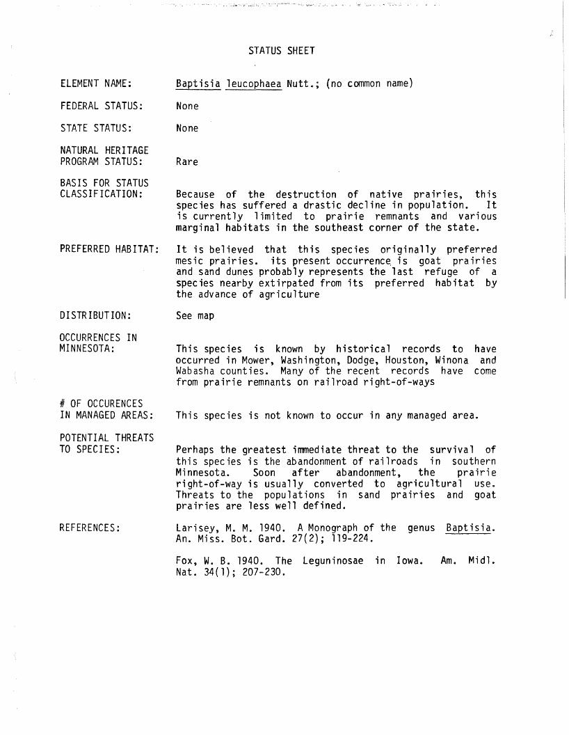
STATUS SHEET
ELEMENT NAME: Baptisia leucophaea Nutt.; (no common name)
FEDERAL STATUS: None
STATE STATUS: None
NATURAL HERITAGEPROGRAM STATUS: Rare
BASIS FOR STATUSCLASSIFICATION: Because of the destruction of native pralrles, this
species has suffered a drastic decline in population. Itis currently limited to prairie remnants and variousmarginal habitats in the southeast corner of the state.
PREFERRED HABITAT: It is believed that this species originally preferredmesic prairies. its present occurrenc~ is goat prairiesand sand dunes probably represents the last refuge of aspecies nearby extirpated from its preferred habitat bythe advance of agriculture
DISTRIBUTION: See map
OCCURRENCES INMINNESOTA: This species is known by historical records to have
occurred in Mower, Washington, Dodge, Houston, Winona andWabasha counties. Many of the recent records have comefrom prairie remnants on railroad right-of-ways
# OF OCCURENCESIN MANAGED AREAS: This species is not known to occur in any managed area.
POTENTIAL THREATSTO SPECIES: Perhaps the greatest immediate threat to the survival of
this species is the abandonment of railroads in southernMinnesota. Soon after abandonment, the prairieright-of-way is usually converted to agricultural use.Threats to the populations in sand prairies and goatprairies are less well defined.
REFERENCES: Larisey, M. M. 1940. A Monograph of the genus Baptisia.An. Miss. Bot. Gard. 27(2); 119-224.
Fox, W. B. 1940. The Leguninosae in Iowa. Am. Midl.Nat. 34(1); 207-230.

LOCATION INSTUDY AREA:
EVALUATION:
This species was first collected in Wabasha County in1883, but the exact location is unknown. A more recentrecord documents the occurrence of the species near thesouthwest boundary of the study area in section 18(Morley, 1961). Another site is known about 1/2 milenorth of the study area (Dana, 1975) and 1/4 milesoutheast (Smith, 1979).
The discovery of this species on a managed area is a highpriority and it should be searched for within the studyarea.
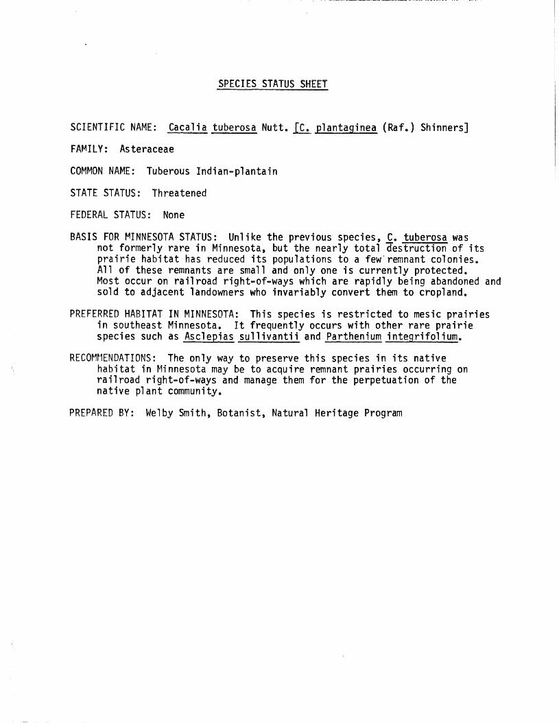
SPECIES STATUS SHEET
SCIENTIFIC NAME: Cacalia tuberosa Nutt.~ plantaginea (Raf.) Shinners]
FAMILY: Asteraceae
COMMON NAME: Tuberous Indian-plantain
STATE STATUS: Threatened
FEDERAL STATUS: None
BASIS FOR ~INNESOTA STATUS: Unlike the previous species, C. tuberosa wasnot formerly rare in Minnesota, but the nearly total destruction of itsprairie habitat has reduced its populations to a few'remnant colonies.All of these remnants are small and only one is currently protected.Most occur on railroad right-of-ways which are rapidly being abandoned andsold to adjacent landowners who invariably convert them to cropland.
PREFERRED HABITAT IN MINNESOTA: This species is restricted to mesic prairiesin southeast Minnesota. It frequently occurs with other rare prairiespecies such as Asclepias sullivantii and Parthenium integrifolium.
RECOMt1ENDATIONS: The only way to preserve this species in its nativehabitat in Minnesota may be to acquire remnant prairies occurring onrailroad right-of-ways and manage them for the perpetuation of thenative plant community.
PREPARED BY: Welby Smith, Botanist, Natural Heritage Program

\."'.
Cacalia tuberosa Nutt.· (c.-.plantaginea(Raf.) Shinners)

SPECIES STATUS SHEET
SCIENTIFIC NAME: Valeriana edulis Nutt. ssp ciliata (T. &G.) MeyerIValeriana ciliata T. &G.]
FAMILY: Valerianaceae
COMMON NAME: Valerian
STATE STATUS: Threatened
FEDERAL STATUS: None
BASIS FOR MINNESOTA STATUS: Although this species was not formerlyrare in Minnesota, the nearly total destruction of prairie andfen habitats has reduced its populations to a few isolated colonies.Most of the recent collections are from remnant prairie stripson railroad right-of-ways. These right-of-ways are rapidlybeing sold by the railroad companies, and are invariably boughtby adjacent landowners for conversion to crop land. Two populationsoccurring in calcareous fens in the Minnesota Valley have recentlybeen destroyed by road construction and commercial development.Populations of Valerian are currently protected at Wild Indigo,Queen's Bluff and Black Dog Fen Scientific and Natural Areas.The typical subspecies occurs in western United States.
PREFERRED HABITAT IN MINNESOTA: This species occurs in three distincthabitats in Minnesota: deep soil mesic prairies, calcareous fensand limestone bluffs. It seems, however, to be most widely occurringon prairies where it may be found with other rare species such asParthenium integrifolium, Cacalia tuberosa and Asclepias sullivantii.
RECOMMENDATIONS: Attempts should be made to protect prairie habitats onright-of-ways from being converted to agricultural land.
SELECTED REFERENCES:Meyer, F. G. 1951. Vpleriana in North America and the West Indies
(Valerianacene). Ann. Mo. Bot. Gard. 38(4):377-503.
PREPARED BY: Welby Smith, Botanist, Natural Heritage Program

------- .........-o-_~_~~ _
Valeriana edulis Nutt~ ~sp. ciliata (T.&G(Valeriana ciliata T. & 'G.)
\.\.

SPECIES STATUS SHEET
SCIENTIFIC NAME: Valeriana edulis Nutt. ssp ciliata (T. &G.) MeyerIValeriana ciliata T. &G.]
FAMILY: Valerianaceae
COMMON NAME: Valerian
STATE STATUS: Threatened
FEDERAL STATUS: None
BASIS FOR MINNESOTA STATUS: Although this species was not formerlyrare in Minnesota, the nearly total destruction of prairie andfen habitats has reduced its populations to a few isolated colonies.Most of the recent collections are from remnant prairie stripson railroad right-of-ways. These right-of-ways are rapidlybeing sold by the railroad companies, and are invariably boughtby adjacent landowners for conversion to crop land. Two populationsoccurring in calcareous fens in the Minnesota Valley have recentlybeen destroyed by road construction and commercial development.Populations of Valerian are currently protected at Wild Indigo,Queen's Bluff and Black Dog Fen Scientific and Natural Areas.The typical subspecies occurs in western United States.
PREFERRED HABITAT IN MINNESOTA: This species occurs in three distincthabitats in Minnesota: deep soil mesic prairies, calcareous fensand limestone bluffs. It seems, however, to be most widely occurringon prairies where it may be found with other rare species such asParthenium integrifolium, Cacalia tuberosa and Asclepias sullivantii.
RECOMMENDATIONS: Attempts should be made to protect prairie habitats onright-of-ways from being converted to agricultural land.
SELECTED REFERENCES:Meyer, F. G. 1951. V~leriana in North America and the West Indies
(Valerianacene). Ann. Mo. Bot. Gard. 38(4):377-503.
PREPARED BY: Welby Smith, Botanist, Natural Heritage Program

\.,,
Valeriana edulis ~utt~ ~sp. cili.ta (T.&G(Valeriana ciliata T. ,'G.)