a recipe for wind two key properties govern the atmosphere: air pressure, dictated by gravity, and...
TRANSCRIPT


A Recipe for WindTwo key properties govern the atmosphere: air pressure, dictated by gravity, and air temperature, dictated by solar and terrestrial radiation. But all these gases making up the atmosphere don't just stay in one place. As you've certainly observed, air moves. The troposphere, the region of the atmosphere we experience every day, is constantly churning with cycles of vertical and horizontal movement. Does it ever seem like it's hotter and windier in the city? That's because a large metropolitan area is basically a wind generator. Vertical air currents result from changes in temperature and pressure. When air heats up, its molecules move around more rapidly, pushing each other farther apart. The air becomes less dense and rises up through the troposphere toward thinner air. In doing so, however, it moves into colder regions and begins to cool. It eventually cools back to a denser state and sinks back down. This is why the troposphere is thickest in hot, tropic regions and narrowest near the icy poles.If the air were all the same temperature and the entire atmosphere experienced the exact same heating and cooling, the troposphere would simply swell during the day and compress back down at night. But in reality, different temperatures persist across the globe, mainly because the sun doesn't provide the same heat to every part of the planet, nor does it shine everywhere at once. While it's daytime on one side of the world, it's nighttime on the other. While one city receives sun filtered down ver tically through one atmosphere's worth of air, sunlight travels to other areas at a more horizontal trajectory. In these cases, the solar radiation is forced to filter through the equivalent of several atmospheres. This is why the sun appears far less bright at sunset than at high noon.Temperature also varies from place to place due to the unequal cooling and heating of land and water. Under a blistering, noonday sun, which is hotter: the water in a swimming pool or the cement patio surrounding it? As your feet can attest, the cement is much hotter, which means it's absorbing more heat. This also means it's reflecting more heat back into the air above it. Now imagine this on a scale of oceans and continents. Altitude, geographic location, cloud cover and ocean currents also affect temperatures around the world.When the air in one area heats up faster than the air in an adjoining area, the pressure differential generates wind. For a simple example of this, look no farther than a large modern city. All that concrete and steel absorbs much more heat than the surrounding countryside. As such, the air in the city grows hotter during the day, becomes less dense and rises in a vertical movement known as an updraft. Meanwhile, the cooler air in the countryside is under far more pressure and begins to flow into the city in the form of surface wind to fill the low-pressure area. Once it enters the hot city, however, it too heats up and begins to rise in an updraft. The air above it cools, but can't settle back into place due to all the rising hot air underneath it. Instead, the cooling air simply pushes out to the sides in the form of upper air wind heading back to the countryside. This wind cycle continues until nightfall sends everything into reverse, as the city cools faster than surrounding areas.
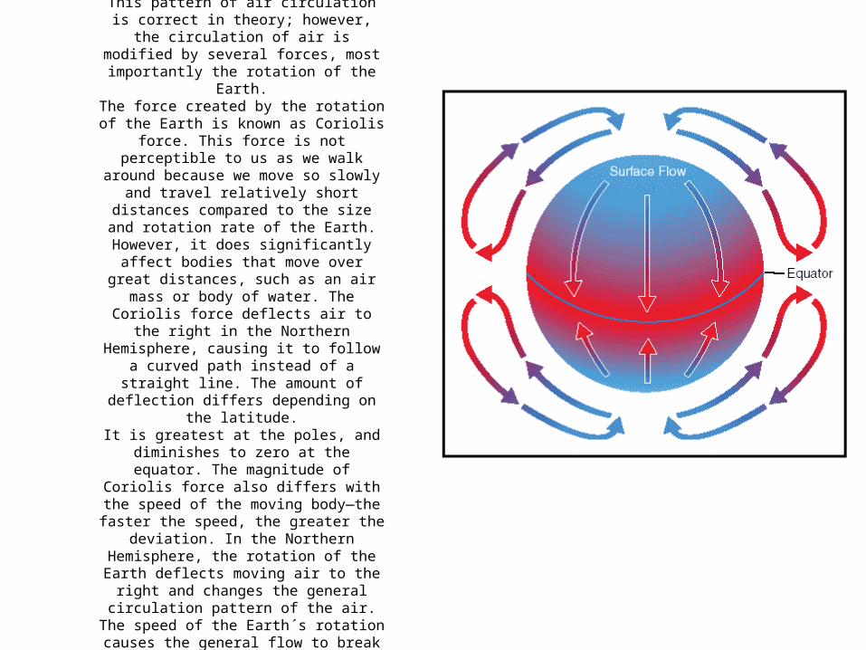
Figure 8: Circulation pattern in a static environment.
This pattern of air circulation is correct in theory; however, the circulation of air is
modified by several forces, most importantly the rotation of the Earth.
The force created by the rotation of the Earth is known as Coriolis force. This force is not
perceptible to us as we walk around because we move so slowly and travel relatively short distances compared to the size and rotation
rate of the Earth. However, it does significantly affect bodies that move over
great distances, such as an air mass or body of water. The Coriolis force deflects air to the right in the Northern Hemisphere, causing it to follow a curved path instead of a straight
line. The amount of deflection differs depending on the latitude.
It is greatest at the poles, and diminishes to zero at the equator. The magnitude of
Coriolis force also differs with the speed of the moving body—the faster the speed, the
greater the deviation. In the Northern Hemisphere, the rotation of the Earth deflects
moving air to the right and changes the general circulation pattern of the air.
The speed of the Earth´s rotation causes the general flow to break up into three distinct
cells in each hemisphere.

Figure 9: Three-cell circulation pattern due to the rotation of the Earth. In the Northern Hemisphere, the warm air at the equator rises upward from the surface, travels northward, and is deflected eastward by the rotation of the Earth. By the time it has traveled one-third of the distance from the equator to the North Pole, it is no longer moving northward, but eastward.This air cools and sinks in a belt-like area at about 30° latitude, creating an area of high pressure as it sinks toward the surface. Then it flows southward along the surface back toward the equator. Coriolis force bends the flow to the right, thus creating the northeasterly trade winds that prevail from 30° latitude to the equator. Similar forces create circulation cells that encircle the Earth between 30° and 60° latitude, and between 60° and the poles. This circulation pattern results in the prevailing westerly winds in the conterminous United States.Circulation patterns are further complicated by seasonal changes, differences between the surfaces of continents and oceans, and other factors.Frictional forces caused by the topography of the Earth´s surface modify the movement of the air in the atmosphere. Within 2,000 feet of the ground, the friction between the surface and the atmosphere slows the moving air. The wind is diverted from its path because the frictional force reduces the Coriolis force.This is why the wind direction at the surface varies somewhat from the wind direction just a few thousand feet above the Earth.


A warm front occurs when a warm mass of air advances and replaces a body of colder air. Warm fronts move slowly,
typically 10 to 25 miles per hour (m.p.h.).The slope of the advancing front slides over the top of the
cooler air and gradually pushes it out of the area.Warm fronts contain warm air that often has very high
humidity. As the warm air is lifted, the temperature drops and condensation occurs.
Generally, prior to the passage of a warm front, cirriform or stratiform clouds, along with fog, can be expected to form
along the frontal boundary. In the summer months, cumulonimbus clouds (thunderstorms) are likely to develop.
Light to moderate precipitation is probable, usually in the form of rain, sleet, snow, or drizzle, punctuated by poor
visibility. The wind blows from the south-southeast, and the outside temperature is cool or cold, with increasing dew
point. Finally, as the warm front approaches, the barometric pressure continues to fall until the front passes completely.During the passage of a warm front, stratiform clouds are visible and drizzle may be falling. The visibility is generally poor, but improves with variable winds. The temperature
rises steadily from the inflow of relatively warmer air. For the most part, the dew point remains steady and the pressure
levels off.After the passage of a warm front, stratocumulus clouds predominate and rain showers are possible. The visibility eventually improves, but hazy conditions may exist for a
short period after passage. The wind blows from the south-southwest. With warming temperatures, the dew point rises
and then levels off. There is generally a slight rise in barometric pressure, followed by a decrease of barometric
pressure.

A cold front occurs when a mass of cold, dense, and stable air advances and replaces a body of warmer air.
Cold fronts move more rapidly than warm fronts, progressing at a rate of 25 to 30 m.p.h. However, extreme cold fronts have been recorded moving at speeds of up to 60 m.p.h. A typical cold front moves in a
manner opposite that of a warm front; because it is so dense, it stays close to the ground and acts like a snowplow, sliding under the warmer air and forcing the less dense air aloft. The rapidly ascending air causes
the temperature to decrease suddenly, forcing the creation of clouds. The type of clouds that form depends on the stability of the warmer air mass. A cold front in the Northern Hemisphere is normally oriented in a northeast to southwest manner and can be several hundred miles long,
encompassing a large area of land.Prior to the passage of a typical cold front, cirriform or towering cumulus
clouds are present, and cumulonimbus clouds are possible. Rain showers and haze are possible due to the rapid development of clouds.
The wind from the south-southwest helps to replace the warm temperatures with the relative colder air. A high dew point and falling barometric pressure are indicative of imminent cold front passage.
As the cold front passes, towering cumulus or cumulonimbus clouds continue to dominate the sky.
Depending on the intensity of the cold front, heavy rain showers form and might be accompanied by lightning, thunder, and/or hail. More severe cold fronts can also produce tornadoes. During cold front
passage, the visibility will be poor, with winds variable and gusty, and the temperature and dew point drop rapidly. A quickly falling barometric
pressure bottoms out during frontal passage, then begins a gradual increase.
After frontal passage, the towering cumulus and cumulonimbus clouds begin to dissipate to cumulus clouds with a corresponding decrease in the precipitation. Good visibility eventually prevails with the winds from the west-northwest. Temperatures remain cooler and the barometric
pressure continues to rise.

An occluded front occurs when a fast-moving cold front catches up with a slow-moving warm front. As the occluded front approaches, warm front weather prevails, but is immediately followed by cold front weather. There are two types of occluded fronts that can occur, and the temperatures of the colliding frontal systems play a large part in defining the type of front and the resulting aviation weather. A cold front occlusion occurs when a fast-moving cold front is colder than the air ahead of the slow-moving warm front. When this occurs, the cold air replaces the cool air and forces the warm front aloft into the atmosphere. Typically, the cold front occlusion creates a mixture of weather found in both warm and cold fronts, providing the air is relatively stable. A warm front occlusion occurs when the air ahead of the warm front is colder than the air of the cold front. When this is the case, the cold front rides up and over the warm front. If the air forced aloft by the warm front occlusion is unstable, the weather will be more severe than the weather found in a cold front occlusion. Embedded thunderstorms, rain, and fog are likely to occur.

In a normal year, the warmest water is in the far western Pacific. This forms thunderstorms.
(Graphic Credit: USA TODAY)
In an El Niño year, the warmest water moves eastward across the Pacific. Thunderstorms disrupt the jet stream changing the weather pattern.
