a r eaofin ts-d il01 - emergency.copernicus.eu · present map shows basic topographic features such...
TRANSCRIPT
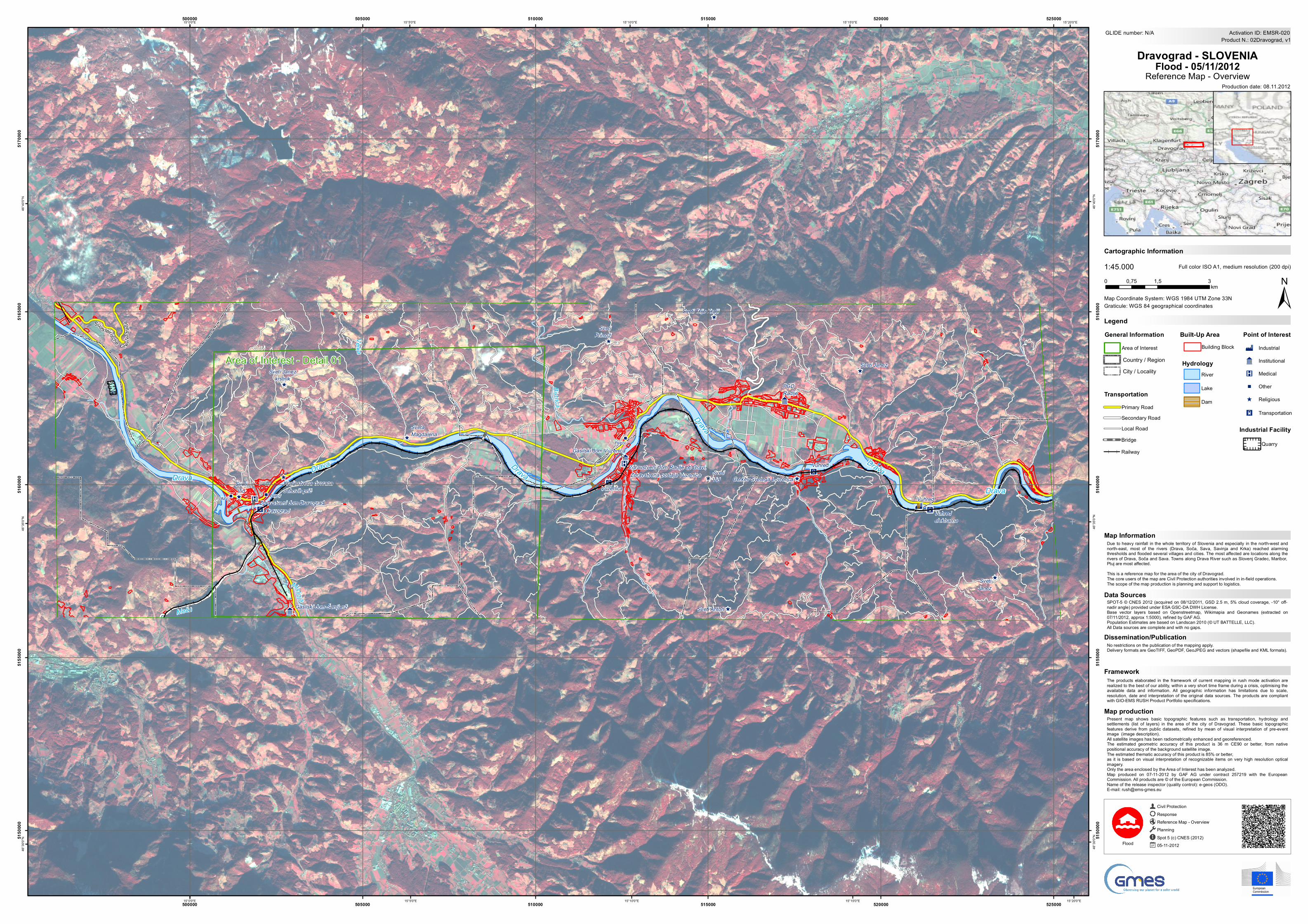
Present map shows basic topographic features such as transportation, hydrology andsettlements (list of layers) in the area of the city of Dravograd. These basic topographicfeatures derive from public datasets, refined by mean of visual interpretation of pre-eventimage (image description).All satellite images has been radiometrically enhanced and georeferenced.The estimated geometric accuracy of this product is 36 m CE90 or better, from nativepositional accuracy of the background satellite image.The estimated thematic accuracy of this product is 85% or better,as it is based on visual interpretation of recognizable items on very high resolution opticalimagery.Only the area enclosed by the Area of Interest has been analyzed.Map produced on 07-11-2012 by GAF AG under contract 257219 with the EuropeanCommission. All products are © of the European Commission.Name of the release inspector (quality control): e-geos (ODO).E-mail: [email protected]
" "
"
"
X
X
X
X
X
D
9
9
9
9
9
9
^
^
^
^
^
^
^
^
^
^
^
^
^
^
^
^
^
^
^
^
^
^^
^
^
^
^
K
K
K
K
DravaDrava Drava
Drava
Drava
Drava
Bis tr ica
Mislinja
Velka
Meža
OMV Petrol
Petrol
Dravograd
Vuzenica
Vuhred
Vuhredelektrarna
Gasilski dom Šentjanž
Gasilski dom Vuzenica
PGDRadlje
Vuhred
SvetiVid
Kraljestvena dvoranaJehovih prič
Sveti Janezkrstnik
SvetaMagdalena
SvetiPrimož
SvetiVid
Sveti Trije Kralji
Sveti Anton
Cerkev Svetega Lovrenca
Sveti Janez
SvetiJanez
Zdravstveni dom Dravograd
Zdravstveni dom Radlje ob Dravi, Zdravstvena postaja Vuzenica
Süd steirische G r e nz
S traße
15°20'0"E
15°20'0"E
15°15'0"E
15°15'0"E
15°10'0"E
15°10'0"E
15°5'0"E
15°5'0"E
15°0'0"E
15°0'0"E46
°40'0
"N
46°4
0'0"N
46°3
5'0"N
46°3
5'0"N
46°3
0'0"N
46°3
0'0"N
500000
500000
505000
505000
510000
510000
515000
515000
520000
520000
525000
525000
5150
000
5150
000
5155
000
5155
000
5160
000
5160
000
5165
000
5165
000
5170
000
5170
000
GLIDE number: N/A
Production date: 08.11.2012
Cartographic Information
1:45.000
±Map Coordinate System: WGS 1984 UTM Zone 33N
Full color ISO A1, medium resolution (200 dpi)
The products elaborated in the framework of current mapping in rush mode activation arerealized to the best of our ability, within a very short time frame during a crisis, optimising theavailable data and information. All geographic information has limitations due to scale,resolution, date and interpretation of the original data sources. The products are compliantwith GIO-EMS RUSH Product Portfolio specifications.
Due to heavy rainfall in the whole territory of Slovenia and especially in the north-west andnorth-east, most of the rivers (Drava, Soča, Sava, Savinja and Krka) reached alarmingthresholds and flooded several villages and cities. The most affected are locations along therivers of Drava, Soča and Sava. Towns along Drava River such as Slovenj Gradec, Maribor,Ptuj are most affected.This is a reference map for the area of the city of Dravograd.The core users of the map are Civil Protection authorities involved in in-field operations.The scope of the map production is planning and support to logistics.
No restrictions on the publication of the mapping apply.Delivery formats are GeoTIFF, GeoPDF, GeoJPEG and vectors (shapefile and KML formats).
LegendGraticule: WGS 84 geographical coordinates
Product N.: 02Dravograd, v1Activation ID: EMSR-020
SPOT-5 © CNES 2012 (acquired on 08/12/2011, GSD 2.5 m, 5% cloud coverage, -10° off-nadir angle) provided under ESA GSC-DA DWH License.Base vector layers based on Openstreetmap, Wikimapia and Geonames (extracted on07/11/2012, approx 1:5000), refined by GAF AG.Population Estimates are based on Landscan 2010 (© UT BATTELLE, LLC).All Data sources are complete and with no gaps.
Civil ProtectionResponseReference Map - OverviewPlanningSpot 5 (c) CNES (2012)05-11-2012Flood
0 1,5 30,75km
Dravograd - SLOVENIAFlood - 05/11/2012
Reference Map - Overview
Data Sources
Map Information
Dissemination/Publication
Framework
Map production
Point of InterestD Industrial
9 Institutional
K Medical
" Other
General InformationArea of Interest
Built-Up Area
TransportationPrimary RoadSecondary RoadLocal Road
Dam
Hydrology
Lake
River
Building Block
City / LocalityCountry / Region
BridgeRailway
Quarry
Industrial Facility
X Transportation
^ Religious
Area of Interest - Detail 01