a plea for the peace - bc bigleaf maple books |...
TRANSCRIPT

Canada’s
World Refugee
Peace River Valley’s
Obligations Met by
British Columbia’s
Site ‘C’ Settlem
entCanada’s
A Plea for the Peaceby Clive L. Justice, FCSLA
& Jill B. Whitelaw, PDC 1999

{Peace River Valley & Site C

1
All great civilizations have had their beginnings in River Valleys beside great rivers. Africa’s Rift Valley remains as the origin of the world’s peoples.
he Peace River is one of Western Canada’s Great
River Valleys. Unfortunately it’s position on globe
earth far from Africa’s Rift Valley leaves it out of the
loop of history becoming home to one of the world’s civilizations.
The Peace River’s less than benign climate has not been conducive
to serious year round settlement, although with global warming
this may change. We will just have to let nature take its course.
owever the Peace like all the world’s River Valley holds
the elements for sustainable human settlement, access
to continuous running fresh water with an obtainable source of
protein in its fish and visiting wild fowl ducks & geese. In addition,
the flooding annually of the valley uplands with receding silt & soil
deposits provide rich & fertile plains for growing annual pasture
gazing grasses and woodland forest trees for fuel and construction.
hile not specific to the Peace, the description of
North America’s continental evaluation of its
climate modifying physical features as described by writers
Jones and Cushman in the Peterson Nature Series The Prairie.
I have copied the part of it that expresses North American
evolution much better than this presenter ever could:
T
H
W
A New Canadian Settlement
* 1000 refugees Settlement Grounds
Should Site C not be built as a dam, it’s land
would need to be regenerated, an opportunity
for refugees who in turn would be helping
Canada to see with a wider perspective.
Our proposal:
* Refugees to be accomodated on arrival
in Canada settled & housed in the Site C
Contractor’s existing large camp.
* all quarters UN operated and managed.
* Refugees learn: by taking training in land
husbandry, Tree Keeping, food and craft
tree management & forest management,
Permaculture; along with learning English, our
Canadian history & cultural heritage.
* PM Trudeau & his Minister of Indigenous
Affairs with Tribal Chiefs of the Peace Region
to meet & welcome the new immigrants

2
rior to the Northern Rocky Mountain uplift the entire
central North American climate had been dominated
by warm moist air masses that swept east from the Pacific from
the Gulf of Mexico. The rising mountains created a barrier that
blocked the Pacific storms squeezing out most of their moisture
before it reached the plains. This rain shadow helped to create
the more arid conditions that favour growth of grasses over trees.
ossils of camels, rhinoceroses, horses and other grass eating
herbivores unearthed on the plains suggest an erratic
progression. Recent analysis of plant micro-fossils indicates that the
extensive grasslands covered parts of the great plains even earlier
perhaps beginning in the late Eocene Epoch, 35 million years ago.
hese early grasslands were dominated by “cool season”
grasses, species that thrive under relatively mild
growing conditions. The quintessential Tallgrasses, including
warm season bluestems and switchgrasses did not begin to appear
until about 10 million years ago. Even then, forests continued to
cover much of the Great Plains with grasslands spreading during
drier climactic periods, and contracting during wetter periods.”
he warming and drying trend continued for several
millennia reaching its maximum intensity between 8,000
and 5,000 years ago. During the height of this hot & dry period
the prairie pushed eastward replacing forests in parts of present
day Indiana Nebraska, Ohio and perhaps Pennsylvania [and also
North into the provinces of British Columbia and Alberta. The
sands of Western Nebraska[Probably North into B.C. & Alberta
also]. All but a few isolated groves of conifers disappeared from
the Western Plains. Bos Bison a smaller more agile species than
the great plains, prairie dogs and ground squirrels proliferated,
and Pronghorn populations climbed into the tens of millions.
bout 5,000 years ago the Climatic Pendulum began
to swing back toward slightly cooler & wetter
conditions. By the time the first white explorers stepped out into
the grasslands the forests had begun to creep westward filling
P“
F
T
T
A
quoted from Peterson Series The North American Prairie by Stephen Jones & Ruth Carol Cushman; Houghton & Mifflin Boston 2004
Implementation
Employment
* Team of consultants (-see A Modest Proposal
to follow) to select suitable site C land location
to establish orchards, prairie water
dugout locations throughout site C area lands
suitably contoured to build permanent Refugee
Settlements based on the Mongolian Model. It is
one of many Site C settlement schemes possible
that can be implemented. Ian McHarg model
recommended. Complete site analysis.
* Tree keeper/management family to include 1
male or female adult, head of household, 4 or less
children - can have 2 babes in arms if the head of
house is female.
* Orcharding: Model to have 32 soft fruit &
hard fruit (edible nuts) orchards & Willows,
Corylus/Filbert, pollarding canes for woven
baskets. (elm, hardy elm), willow & garden
stakes & woven wooden fences now fences.

3
the pockets of prairie on the Great lakes region & the upper
Mississippi River Valley [and Northward to the Peace River Valley]
evertheless, all of these early travelers marveled at the
expanse of grass that seemed to extend forever beyond
the last islands of forest. Nineteenth-century author Washington
Irving characterized the landscape as being “inexpressively lonely”
and like “a desert world.” Writer Francis Parkman referred to it
as “a barren, trackless waste.” In contrast, nineteenth-century
artist George Catlin extolled a land of “soul-melting scenery...
where I Heaven sheds its purest light and lends its richest tints.”
hatever their opinions, writers & artists realized that the
Canadian Prairie Landscape as opposed to the settled
Landscapes of Britian, Europe and Eastern North America - it, the
Canadian Prairie remained an evolving landscape. The BC Peace
River, Grasslands with those of Alberta that blend into the Alberta
is: hidden lakes and wooded rolling prairie lands extend East to meld
into a background of the Caribou Mountains, Buffalo Head Hills &
Birch Mountains complex. East of the hills & mountains lies the
Athabasca River, the tar sands, the tar sands extraction rendering works
& the open pit mines-holes around the Fort McMurray Settlement.
he Peace in the North winds & snakes around
the south end of these Caribou Mountains
and flows into Wood Buffalo, now the home of Canada’s
B o s B i s o n and the endangered Whooping Crane Grus americana . It is the second largest of Canadian National Parks.
t continues to the east where it becomes a series
of lakes at east and of Lesser Slave River flowing
North to Great Slave Lake. It one of the Canadian Arctic’s
Great Lakes that remain from the melting of glaciers that
once covered Canada’s part of the North American continent.
he first attempt at human settlement of the BC Peace
River open grasslands, Alberta wooded rolling land,
hidden lake & small lakes, prairie occurred just after the end of WW1
T
I
N
W
The Mongolian Settlement Model has
the components to provide 1000 refugee families
with sustainable year round food supply via
an adequate and sized family shelter warmed
throughout the winter by our endless supply of
affordable natural gas, passive solar, and chickens
which can be used for food, and also give off
heat.
* to sustain 100 refugee families in construction
buildings followed by a transition to greenhouse
living, and a possible larger Arcology, see
Miscellanea
* Each 100 family settlement to have living
quarters:
48 - 4 and 8 block settlements, Each one of the
blocks are either 4 homes or 8 homes, with cross
corridor to entrance, connected to 32 year round
greenhouses. Each greenhouse operated and
managed by 1 refugee family.
* Site:
Site selection: These writers favours Ian
McHarg’s book Design with Nature, the key
to maximizing the refugee & indigenous
settlements, their numbers, & locations on the
Peace; and Tasmania’s Bill Mollison’s Book,
writings on Permaculture, A Designers’ Manual.
* In addition each 100 family settlement
area includes 32 or more separate Prairie water
dugouts and strings of combined dugouts.
* as the Settlement ground contour dictates
settlement grounds amount 250 hectares more T

4
in 1918-19, was by the Canadian Federal Government. The Peace and
Alberta lands were called the Dominion Soldier Settlement Lands and
were also subdivided into 10 and 20 acre plots to be sold to returning
veterans and their families at very low prices with long periods &
payment at very low interest rates to Veterans and their families.
There was a minimum of infrastructure, veterans could earn enough
working on roads, gravel roads, settlements sites, school sites and the
like. It was not only other Valleys in Southern BC that were opened
for soldier’s settlements. Whereas not only in other valleys Keremeos
in the adjoining east side of the Okanagan Valley and the adjoining
Similkameen Valley. The Fraser Valley’s Lower Mainland the program
continued in 1945 for veterans of WW2 in Richmond, the Cowichan
Valley on Vancouver Island, and Vernon in North Okanagan.
he Dominion Soldier Settlement scheme on the
Peace River lands was never very successful in
attracting settlers; it’s harsh Northern winters and remoteness,
probably the main dissuading features. The Alberta Woodland
lake land did prove attractive to settlement to veterans & other
non veterans previously in settlements such as Beaverlodge
where the Dominion Government established a crop and plant
experimental station. See Vic Chanasyk, page 1 of Miscellanea.
ther successful prairie land settlements in Alberta produce
Grand Prairie, Spirit River & other smaller settlements on the
Alberta side, with Dawson Creek and Pouce Coupe on the BC side.
n this Landscape Architect’s opinion, British Columbian
Peace River valley grasslands are ready and waiting for the
settlement. Not for veterans who are fighters of wars but their children
and grandchildren remanent of their families who are victims of wars.
n preparing Site C, that part of the Peace lands
for the damming and flooding, BC Hydro, a
provincial company, has built accommodations for it’s fort’s
employees & prepared the ground for dam construction
to flood Site C. By fortunate coincidence is made ready
to take the first wave of 1000 or so refugee immigrants.
O
I
T
I
or less (rough guess by water could be larger or
smaller well dugout.
* Dugout or string of dugout, string of lakes,
drainage ground lake and prairie dugout ground
slope.
* Woodland for fibre & tree wood, hardwood
trees for lumber, woodlands located as shown in
Mongolian Model see miscellanea image of site
and greenhouse and adaptation for Site C.
* Tying together site with sounding lake &
hillside, woodlands, an open prairie, grasslands,
strings of lakes, bands of forest woodlands to
give each Site C settlement a natural landscape,
pleasing visually.
* Restored Landscape - using trees, swales ( a
tree system), ornamentals as well as edibles.
Transportation
* Look to town of Churchill, Manitoba &
Bombadier Company as examples.
* Find ways to include Canadian
communities & companies to provide a
transport system to residents - Bombadier
fleet of snowmobiles, maintenance
teams, crews & staff to teach operation &
maintenance. Churchill, Manitoba to provide
knowledge of polar bear proof snow vehicles;
where they solved their bear problem by
devising safe work and transportation
equipment.

5
start to settle, house & feed the world’s current
great human disaster. Those thousands of children
and families who have lost everything, their homes, family
members, and perhaps worst of all, their country. These people
have lost their place in the world along with their hope.
y proposition is: Canada through the
United Nations for Our Country
to redeem its place in the world, a place where
hope can return and regain for the war ravaged immigrant, a
place back in the world in Western Canada’s Peace River Valley.
he process could begin almost immediately. BC
Hydro, Peace land owner, a BC Provincial body, could cede the
land & preliminarily preparation land work and existing worker
housing to the Canadian government, who then would give it to
the UNHCR, United Nations High Commissioner for Refugees,
who would ‘Run the Show’, or most of it. From selecting the
immigrants to transporting them to the Peace, building additional
housing and infrastructure. It would become the one Grand
Canadian Gesture for humanity. Take up where we left off with
newly funded mandate, for the Blue Berets in Peace Keeping.
Let’s Do it Now!
Respectfully, with due Canadian Caution & Consideration our
two most Canadian traits.
A
M
T
Canadian Senator,
General Romeo
Dallaire, Canadian
Force Commander
of UNAMIR,
wearing the blue
beret of the UN.
Planting Trees:
Treekeepers planting the Rotary Heritage
Forest on the Cassiar Connector in NE
Vancouver, 1996
Clive Justice seen here as
site co-ordinator,
Vancouver South Rotary

6A Plea for the Peace by Clive Justice supported by the following documents

7
Mongolian Model
1 Mongolian Settlement Unit - Hailar, Jan She Village Site as Model

8
The site C modification accommodation
between the greenhouses. Drawing by Stephen
Sinclair, Architect, Landscape Architect.
Carpathian Walnut Juglans regia var carpathian
see story page M1

M1
View of the Peace Canyon Dam bridge site including Highway 29 suspension bridge to Hudson Hope. photo CLJ
Victor (Vic) Chanasyk was born in Alberta the son of parents
& grandparents Ukrainian Peasant farmers who had emigrated from the
Russian Steppes, driven out in one of many waves that occurred in the
Nineteenth & early 20th century. After graduation from a rural Alberta
highschool, Vic Chanasyk enrolled in the University of Alberta, in the
Province’s capital city of Edmonton in the faculty of Agriculture and
Horticulture program under Dr. Robert J. Hilton, professor of Horticulture,
authority on Amelanchier, the Canadian Prairie native Saskatoon berry and
other native prairie berries. [Several were the ingredients with plains Bison
fat of Pemmican]
On graduation Dr. Robert Hilton saw to it that Vic got employment
in Alberta’s Experimental Station in Beaverlodge. It was not long after
that Vic made superintendant of the station. In the 50’s Dr. Hilton again
stepped in on Vic’s behalf & arranged for his favorite student to take the
4 year course in Landscape Architecture at UC Berkeley. Vic was the first
Albertan [second western Canadian to become a Landscape Architect.
Again with Dr. Hilton’s influence Guelph school of Agriculture was selected
to be the first school of Landscape Architecture in Canada to teach a full 4
year program in landscape Architecture. Victor Chanasyk became it’s first
Dean, or Superintendant, again with Dr. Hilton’s help who was tending his
Carpathian walnut trees.
MiscellanaeA Peace

A Modest Proposal
To Use the Site C De-Treed Areas of the Peace River Lands
for Silviculture and Permanent Agriculture
by Clive Justice & Jill Whitelaw
Site C is now cleared and graded, lying fallow, and awaiting development proposals from sustainable
environmental believers & practitioners with vision and initiative. Greenpeace, Sierra Club BC, the Wilderness
Committee & the David Suzuki Foundation are all globally active, locally founded, environmental protection
offices in our Province. BC is now working together across political party lines with the Green-NDP Coalition
to support appropriate eco-sustainable options for our energy. Let it continue. One suggestion is autumn
seeding in Fall 2017, before the first snowfall with Helio-hydro seeding of winter hardy rye grass, Lolium perenne
var. ‘Olds, alta’, followed in the spring planting Poplars, Populus trichocarpa in the forest, in swales, woodlots,
clumps and thickets along the valley bottom and hillside stands.
What if the pulp were then sent through a pipeline, perhaps even an existing or
approved one, through an extended network of woodchip-slurr y pipes? What if i t were
powered by wind generators or solar al l the way along?
These Cottonwood hybrids are selected because the wood fibre makes a long-staple fibre
suitable for newsprint, copy, kraft & fine papers, books, periodicals, cartons, packaging products,
paper towels, tissues & toilet paper. One in particular, the Crown Zee Tacoma Cottonwood Poplar
the Peace River in Spring by Tuchodi /flickr

tree Populus trichocarpa Torr. & Gray is one of the best. Another hybrid with very white wood can
be manufactured into white paper using little or no bleach.
The BC Society of Landscape Architects / BCSLA’s land management, professional commitment entails
a full understanding of each of the provinces tree species palette [species of conifer & deciduous]: specifications
for arrangement of stands of trees for forests, copses, 3, 5 or 7 tree clumps, lone tree landscapes, and edges: fall
colour, density of colour, size, scale, how it fits into the landscape or into the meadow. Or, for example, initial
planting of a temporary landscape of introduced different Populus species which will be harvested and made
into pulp.
What if a Pipeline linked to the existing operational processing mills, and even closed mills & new
paper and pulp mills up and down the BC Coast & Islands: Prince Rupert, the new Kitimat mill, the existing
mills in New Westminister, Nanaimo, the Albernis, Crofton, Cambell River; and mills closed, mothballed or
contemplated in process of being built or planned, throughout the Pacific Northwest, and our neighbours to
the South: the mills in Everett, Tacoma, Idaho, Portland, etc.? A Pulp and Paper Pipeline for a myriad of
Paper Products, serving not only our country, Canada, but also the rest of the world with our forest resources,
technology & experience. Canada has more of this resource than any other part of the world.
We were so distracted by gas, drilling, fracking, LNG, bitumen, and extracting oil and gas from our
Canadian prairie, Arctic & subarctic surface lands ruining, destroying & laying waste to our Northern Tundra
surface landscape. We should have been ashamed but instead we buried them! We Canadians ‘shilly-shally’ on
this issue and want to trust our government to make the right choices, to face up to the fact that fossil fuels are
carcinogenic and non-renewable. The future of our world ought to remain pristine, natural and beautiful for 7
generations. We have a lot of bio-remediation to get this world back in shape after the promise of the ‘American
Dream’.
Each region has its own micro climate, species and visual landscape. What is needed is an Aesthetic,
Education and Management Group for deliberating and guiding reforestation and sustainable harvesting. The
BCSLA working group with the region’s tree and resource experts, the BC Forestry Service (BCFS), UBC
Silviculture, SFU Resource & Environmental Management, local agronomists, Indigenous Land Management
and permaculture farmers to set planting standards for spacing and species, for the planting and maintaining

of pulp tree forests, clear-cuts, other forests, copses and woodlots, thickets and hedgerows, lone tree aesthetic
landscapes, plantings by the rivers, and pasture feeding lands for wildlife.
A great practice would be to modify the arable Peace River Valley into grass hillsides, and
rolling slopes with a series of berms and swales along contours, where trees are planted. Debris such
as leaves collect in the swales to support the tree crops, as well as rainfall or water released from small
earth dams or bodies of water above and channeled into them. This aids retaining the beauty of our
landscape by inter-cropping our fast growing trees with nitrogen fixing trees and plants, cold-hardy and
useful vegetation, cash crops, native plants, edge and companion plants for pest management, wildlife
foraging, flowers for bees, creating a polyculture rather than a monoculture, all eventually successioned
by replanting a natural selection of Canadian trees of that region.
This land has been disrupted, and needs to regain biodiversity and balance. Mature forests have mushrooms
and shade loving groundcovers, shrubs and native wildflowers under the tree canopy. The more mature the forest
the more there is in it. Paul Stamet’s has a product called the LifeBox, a box filled with Pacific Northwest tree
seeds as well as mushroom spores. Stamets, from Oregon, also migrates through this region and may even help us
design a very local LifeBox. Trees and mushrooms make up the bottom most and top most elements of a forest. In
between are the other layers of the forest, such as shrubs and vines, which if they were native edibles such as small
berries, or native potatoes-like plants could be highly productive for edible species and wildcrafting the commons
and allowing even more opportunity for a balanced economy for all Canadians.
There is a need for improvement throughout the Peace Valley lands & unflooded bottom lands from just
below the Site 2 dam structure to just below the site C area with the reservoir area, and the surrounding areas to
the natural boundary at the BC-Alberta boundary. The top water line to the lower water line we can’t landscape,
but all of the lands around and above, that will be these gardens. Plant on cleared areas or in valleys on rolling
terrain in plantations or in designated large farm areas.
Different ornamental gardens could be added. For celebrating Canada’s Confederation of 150 years,
for example, honouring pioneers, explorers, settlers and natives could include landscape heritage gardens from
England’s settlers, the Garden in Memory (CWLA, CLJ Chapter 11, 2013.) which they brought to Canada
to live in this harsh landscape as pioneers, learning from Canada’s landscape and plants and First Peoples to

survive. To celebrate this vast tract of land in good commemorate & try to reflect the made improvements.
Capability Brown, was nicknamed “Capability” because he would tell his clients that their property had
“capability” for improvement.” (wiki) He was an English landscape architect. He is remembered as “the last of
the great English 18th century artists to be accorded his due”, and “England’s greatest gardener”. He designed
over 170 parks, many of which still endure. He Each park farm or garden to contain heritage plants, such as
trees, flowers and ornamentals developed by Canadian horticulturists, Frank Skinner of Dropmore, Manitoba
for roses and lilacs, and Isabella Preston of Dominion Agriculture for lilacs and lillies, and the ornamental
crabapples, Malus niedzwetzkyana hybrids.
With the onset of computer technology everybody thought we were going to a paperless society, when
in fact we could become the greatest paper, wood, fibre society ever. Look around, there are more newspapers
than ever before, we still use and read books, give birthday cards, send and receive mail, ship globally and in
cardboard boxes, ad infinitum. Canada, especially BC has experience with paper production technology and
could be a market leader throughout the world. Pulp & paper technology puts Canada in a position to be one
of the largest pulp & paper producers & exporters in the world, with the possibility to become very rich, a very
un-Canadian idea, however, The pulp & paper industry, is a low carbon industry. By sequestering carbon into
trees, and keeping that carbon in solid carbon form, that is, not burning it, but by turning it into pulp and paper,
as well as furniture, shelter, garden trellises & structures, books, etc., we bring down the global carbon balance
closer to 350ppm, a place where our storms subside, and our climate and biosphere may return to normal, pre-
industry levels of atmospheric carbon, recreating our natural ozone layer. The Clayoquot Sound Biosphere
Reserve is a great example of sinking carbon indefinitely.
Clive Justice is Landscape Architect, Urban Planner & Garden Historian. He lives and works in Vancouver BC.
Jill Whitelaw is a Graphic Designer & Book Publisher with BC Bigleaf Maple Books. She is also a
Permaculture Consultant & Educator living in East Vancouver.
*links are found on the pdf /digital version for further info. See http://bcbigleafmaplebooks.ca
Landscape photo can be found on flickr at https://www.flickr.com/photos/tuchodi/3551991021

M6
Peace River Site C
Western Canadathe forests of Western North Americaas far East of Hudson’s Bay

M7
The Forest Regions
from Native Trees of Canada R. C. Hosie
The forests of Canada can he divided into nine regions based on marked differences caused by terrain, soil and
climate. A composite map of the regions is re-produced (on the next page).
The Boreal Forest Region This Region comprises the greater part of the forested area of Canada. It forms a
continuous belt from Newfoundland and the Labrador coast westward to the Rocky Mountains and northwestward
to Alaska. White Spruce and Black Spruce are characteristic species; other prominent conifers are Tamarack
which generally ranges throughout, Balsam Fir and Jack Pine in the eastern and central portions, and Alpine Fir
and Lodgepole Pine in the western and northwestern parts. Although the Boreal forests are primarily coniferous,
there is a general ad-mixture of deciduous trees such as White Birch and poplar; these are important in the central
and south-central portions, particularly along the edge of the prairie. In turn, the proportion of spruce and larch
increases to the north and, with the more rigorous climate, the close forest gives way to an open lichen-woodland
which finally changes into tundra. In the eastern section, along the southern border of the Region, there is a
considerable intermixture of species from the Great Lakes-St. Lawrence forest, such as Eastern White Pine, Red
Pine, Yellow Birch, Sugar Maple, Black Ash and Eastern White Cedar.
Research Stations: Experimental farms around Canada for the cultivation of hardy plants

M8
Permaculture is permanent agriculture, permanent culture, Deep Ecology, a fairshare sense of abundance
moving in renewable, foundationally good ways to provide for the future and the present. Permaculture is a way
of life; it is a cycling of life, collecting energy from the sun and wind and water and using it as many times as
possible before releasing it into entropy, in water’s case, the ocean. Looking at the Permaculture Flower, we see a full
spectrum of life is possible through living in a cyclic harmonic way.
Key boons of Permaculture include farming on swales, along contour, planting tree systems, using keyline
dams, and succession. If we could farm Canada, we could mulch-in the hardy edibles, the fuel crops, and the tender
food crops. Massive greenhouse domes could allow us to produce tropical fruit and warm our houses as done at
the Rocky Mountain Institute in Boulder Colorado. Other tried and true ways have persisted through the ages and
the cultures, such as the Yeomans Plough, and endless variations of small earth systems, are here for learning and
creating with. It is happening around the world, this funny word Permaculture. I like it more and more. I think it
means we like ourselves.
Building soil is an ongoing process, and a wonderful one which yields fruit and nut, seeds and greens, and
is served by farm animals’ manure, seaweed, biochar to name a few. Could we have a small herd of nomadic goats
on Vancouver Rooftops and lawns that replace loud and polluting mowers, when the grazers have always done this
Permaculture in the Peace River Valley

M9
job, leaving gifts of natural fertilizer in their wake? Joel Salatin has an amazing book called Folks This Ain’t Normal in
which he describes his experiences farming with animals, grazing them in different areas of land and moving them
around to get the goodness they find of the soil and plants, leaving behind what they don’t need (fertilizer).
The people are suffering right now. Some people don’t seem to realize that Earth is worth saving, and
that all people are redeemable, in a good way, can regenerate, most especially if he or she is willing to go through
healing and wellness, with the support of friends, family and community. We are collectively living through truth
and reconciliation here on unceded Coast Salish Land and Waters and in Canada, in a process of regenerating
culture, and people, to find some resolve and better ways of life. We also have new tools in our toolbelts, tools to
use to talk about how we are feeling and what we are needing. Non-violent communication, or Compassionate
Communication, thanks to Marshall Rosenburg, is a language of observations, feelings, needs and requests, so we
can speak for ourselves, for inspiration, and come and work together for a greater good.
from: https://permaculturepower.wordpress.com
Forest Fires in BC and How Swales Harvest and Sequester Water As our climate warms, we are seeing more smoke in BC. This week we had a good week or two of
forest fires affecting the
Vancouver environs and
weather with the smoke.
One idea is to dig
swales every 25- 50
yards along contour on
crown land, on clearcuts,
private land, etc to catch
and retain water.
Swaling Site C
could restore the land
and be a model for
a new Experimental
Demonstration Farm.

M10
or straw piled into
mounds upon a low
wetland gives extra
nutrients and serves
as a great mulch.
Algae has incredible
possibilities.
A note about
biofuel. Natural gas
may be like biofuel but not fracktured natural gas, as
the process used to retrieve it is toxic. There is enough
natural gas to last us 50 years. (CLJ) See Fractured
Land movie with Caleb Behn.
Biofuel can be produced out of nitrogen rich
compost, including biosolids, or algae. A pipeline
devoted to 100% mixed biofuel suitable to run in cars
and engines – would be a better option than that of
Poop powered buses are coming to Vancouver –
and many more cars could run on alcohol. Chinampas,
as grown in Mexico in freshwater lakes, for growing
food or biomass in a wetland, is one of the most highly
productive systems. Bucky Fuller did similar under a
geodesic dome greenhouse with a pond installed in the
centre, keeping the microcosm warm and wet. John
Todd took these concepts into a ship life mentality of
survival with his company Ocean Arks International.
He and his team developed eco-machines to clean
water, filtering off the sludge then using reeds, rushes,
and Irises, to grow other plants, out of those nutrients,
provide animal fodder, houseplants & clean water using
all 5 kingdoms – crustaceans, fungi included. Todd
grows in water but seems to eliminate the substrate
as he is working to clean water. However, in growing
food, as in soil or in chinampas, a base of straw bale
Biofuel In the Twinned Pipeline and Solutions for Renewable Energy BC Hydro could Adopt
Bristol’s Bio-Bus is powered by fuel derived from food waste and sewage. Image Courtesy, Wessex Water

M11
trying to harvest hard to get carcinogenic petrochemical
bitumen or fractured gas. Vancouver’s buses are
rumored to be run on Biofuel in the near future, as are
Bristol’s buses now are.
There are many options for a non-polluting
renewable biofuel. Canada has renewable resources
which managed and harvested, at sustainable rates, can
provide much for us and to share with the world.
For local farming and energy production
with lots of leftover as an industry/jobs/economy:
Swales and Algae. Swales and mulch will help us
collect and direct water and we could likely grow
algae in a swale. But in case not, David Hazelbeck of
Global Algae Industries is learning how to use it as
a significant food source. Run as a co-op it may do
quite well.
Thorium is worthy of being mentioned as well,
as it could produce electricity through much less use
of water. Thorium is a nuclear power which has the
potential of giving much, with many less side effects
than traditional nuclear energy, and the material,
thorium is abundant and everywhere. Each person’s
lifetime use is about the size of 3 smarties.
BC Hydro would be good to bury electrical lines
underground as recommended by Dr. Clive L. Justice,
as Landscape Architect & urban planner. Immediate
jobs for those displaced workers from Site C to put
wires underground – England and other countries have
done this – good for the visual landscape and good for
the people – the earth / ground grounds energy while
our bodies are sensitive water – bagged emotional
Vancouver’s district heating - Global News
One legacy of the 2010 Vancouver Winter
Olympics is the False Creek Energy Centre, which
provided heat to the Olympic Village. It does this by
drawing heat from raw sewage.
The raw sewage is warm because of the hot water
from people’s showers and kitchens, which they wash
down the drain, says Brian Crowe, director of Water,
Sewers and District Energy for the City of Vancouver. As
it flows through Vancouver’s sewers, it’s usually between
12 and 20 degrees Celsius. When it reaches a sewage
pump, some of the warm sewage is diverted, screened, and
directed into a heat pump. The heat pump, with a little
electricity, heats up some water, which is then pumped
into radiators around Southeast False Creek.
mental physical beings.
Manoj Bhargava and his extensive team are changing
lives for many families with a stationary bicycle that
powers homes using 1 hour of human power to give
electricity all day. Small scale renewable energy where
excerise is a by-product. Good News.
Algae farms may be the big game-changing
solution. Thorium? Well, maybe too.
M12
Arcology - A Permaculture Response to Refugees in the Peace Valley
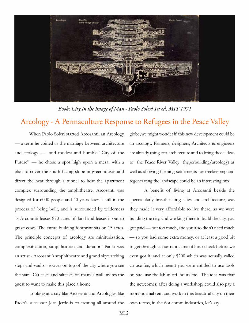
Book: City In the Image of Man - Paolo Soleri 1st ed. MIT 1971
When Paolo Soleri started Arcosanti, an Arcology
— a term he coined as the marriage between architecture
and ecology — and modest and humble “City of the
Future” — he chose a spot high upon a mesa, with a
plan to cover the south facing slope in greenhouses and
direct the heat through a tunnel to heat the apartment
complex surrounding the amphitheatre. Arcosanti was
designed for 6000 people and 40 years later is still in the
process of being built, and is surrounded by wilderness
as Arcosanti leases 870 acres of land and leases it out to
graze cows. The entire building footprint sits on 15 acres.
The principle concepts of arcology are miniturization,
complexification, simplification and duration. Paolo was
an artist - Arcosanti’s amphitheatre and grand skywatching
steps and vaults - rooves on top of the city where you see
the stars, Cat casts and siltcasts on many a wall invites the
guest to want to make this place a home.
Looking at a city like Arcosanti and Arcologies like
Paolo’s successor Jean Jerde is co-creating all around the
globe, we might wonder if this new development could be
an arcology. Planners, designers, Architects & engineers
are already using eco-architecture and to bring those ideas
to the Peace River Valley (hyperbuilding/arcology) as
well as allowing farming settlements for treekeeping and
regenerating the landscape could be an interesting mix.
A benefit of living at Arcosanti beside the
spectacularly breath-taking skies and architecture, was
they made it very affordable to live there, as we were
building the city, and working there to build the city, you
got paid — not too much, and you also didn’t need much
— so you had some extra money, or at least a good bit
to get through as our rent came off our check before we
even got it, and at only $200 which was actually called
co-use fee, which meant you were entitled to use tools
on site, use the lab in off hours etc. The idea was that
the newcomer, after doing a workshop, could also pay a
more normal rent and work in this beautiful city on their
own terms, in the dot comm industries, let’s say.

M13
The Peace River Valley region is extremely rich
in lush green plants and is home to many species, and
many of those are endangered. In Vancouver’s case, we
are situated in the middle of the estuary with our cars and
constant waste. To be up a hillside is good as it takes us
out of the water way. Fort St. John is right on the other
side of the river.
If an arcology were built on site C, it may be a
place for many more to settle. Local First Nation refugees
from around our country may find a place here, as well as
other refugees, citizens or travellers who needed a place.
A general population guideline of 6 Canadians per 1-2
refugees to help their transition into Canada, as well as
provide a new development in the North which aimed to
welcome many different people, offering an affordable
lifestyle for people building the city or planting trees.
Arcologies are designed cities which can hold 6,000 to
10,000 to 1,000,000 people. Jean Jerde saw Soleri as his
mentor and continues to build Arcologies worldwide.
h t t p : / / j e r d e . c o m / p l a c e s
https://arcosanti.org/

Permaculture NewsHow to Build a Swale on Contour Successfully
from https://permaculturenews.org/2015/07/24/how-to-build-a-swale-on-contour-successfully/
July 24, 2015 by Jonathon Engels
Swales are amongst my favorite permaculture projects. Though they can be laborious, especially for a shovel and
pick fellow like me, they show results quickly and look amazing, texturing the landscape with both purpose and beauty.
They are easy to explain: Everyone understands the concept of plants needing water. Swales are also perfect for those of
us wanting to build no-dig garden beds, as digging the (swale) paths provides the necessary topsoil.
There are so many more reasons. Modern inclination is to get rid of rainwater as quickly as possible, ushering it
into gutters and drainage systems, which often lead to a plethora of contaminants, including sewage getting into fresh
water sources. Afterwards, when there’s a dry spell for a few days, the sprinklers come out. Instead, swales stop the deluge
and allow the water to slowly, passively enter the soil and keep stuff working, preventing overfilling drainage systems and
the need for compulsive watering. What a concept!
Learn from leading examples in the field of regeneration...
So, with such an endorsement, surely everyone is salivating at having a swale of their very own, even those who
still aren’t quite certain what a swale is. Well, if that’s the case, hang on for another paragraph or few, and let’s get to it.

The Swale on Contour
For the sake of swale newbies, the basic concept of a swale on contour is to catch water as it drains and hold it
in place until it absorbs into the ground. It looks a bit like a massive ditch with closed ends, trapping all of the water as
opposed to having it flow anywhere. Other swales systems, also known as diversion ditches or soil conservation swales,
are meant slow down the movement of water in order to allow it to partially absorb, catch sediment, and/or prevent
erosion while slowly ushering it elsewhere, like a reservoir. However, a swale on contour aims to keep all the water in
place until it is absorbed. YouTube! Video: Permaculture Water Harvesting through Swales
“On contour” simply refers to the fact that this sort of swale works on the principle that by keeping everything
level, such that the path of the swale moves along the contour, or elevation curve, of a slope. Doing this means that the
water absorbs evenly into the land below as opposed to flowing to the lower end of the swale. Without following the
same elevation level, the water would flow to one side or the other, and preventing this flow is what makes the water
become passive rather than destructive, as is the case with water draining en masse and quickly in one direction.
Lastly, another nearly ubiquitous feature of swales is the result of all the soil that is removed to create them: the
berm. The berm sits on the downhill side of the swale and is the perfect place to grow trees and deep rooting plants like
strawberries, rhubarb, asparagus, comfrey, and dandelions. The deep roots will keep the berm stable, as well as suck up
the moisture from below so that the newly hydrated soil doesn’t become overly saturated.
The Right Tools for the Job
In a world with greater money sources than spring from my pockets, as well as more technological knowledge than
I currently retain, swales can be fairly hi-tech operations. Laser levels can help find the contour lines of a property,
and major league digging equipment can be brought in to quickly, painlessly (at least from the human side of things)
excavate. For a massive swale, something more river-like than what most of us will attempt, this makes sense. For me,
however, the world of swales is a bit more rudimentary.
To be completely frank, half of the reason I got into gardening and, subsequently, permaculture is that I enjoy
being outside and on a project, getting dirty and fixing problems. If there’s a hole (or swale) to be dug, I want a shovel. If
there’s something that needs to be level, like the bottom of a contour swale, well then, a water level will suit me just fine.
And, when it comes to finding that contour line, I was both happy and enlightened to discover the simple but effective
A-frame. YouTube! Video: How to Make a Permaculture A-frame Level
An A-frame is called thusly because basically one must build a capital “A” out of wood to make it. The two
legs need to be of equal length, just as our elementary school teachers taught us, and about midway down, they’ll be

connected by a third piece of wood, equidistant from the bottoms of the legs. Aim for the open end of the A to be
between three and six feet. Then, there are two options:
1. Mark the exact center of the crosspiece and hang a plumb line from the center point at the top of the A. When the
plumb line hits that centerline on the crosspiece, then the two feet of the A are on level playing fields.
2. Or, simply strap a water level to the cross bar so that when it’s level the two pieces of ground upon which the A is
resting are the same elevation.
Choosing the Right Place
Before digging anything, it’s important to carefully determine the rough location of where to place a swale. In
doing so, it’s imperative to consider the gradient, as a swale should only put installed on something with nothing more
than 15% gradient, or a slope that climbs roughly 1 meter for every 7 meters it moves horizontally. Following this rule
prevents mudslide problems that steeper gradients would cause, and that could potential be devastating to a property.
Other things to consider are that the longer the swale can stretch the wider reaching the water absorption will
be, and the higher it’s placement the more space in which the water will have to expand underground. So, ideally, a swale
will be installed at the highest point possible but still low enough, downslope, to catch water run-off. From here, spread
the water out on level plain by extending the swale on contour for as long as possible, that way water can absorb evenly
into the land downhill. YouTube! Video: Full Swales
Lastly, what I’ve noticed in my successes and failures of playing with swale systems is that, if there isn’t a
noticeable flow of water to feed the swale, it may not fill, rendering the effort much less advantageous than once hoped.
I’ve built several swales, some of them absolutely required a passive overflow, others never held more than a couple of
inches of water in the middle of a rainstorm. I now make sure I know where a significant source of water will be coming
from before putting in the effort.
Putting the Right Tools to Use in the Right Place
Once the general area is decided upon, it’s time to get more specific, which means pulling out that A-level we
built a couple of sections ago. Use the A-level to stake out the contour line and the exact route the swale will be taking.
This will likely not be a straight line, but rather a sexy, curvy number that’ll give the system some personality, like those
amazing terrace gardens in Asia. Mark the entire thing out, including a safe area for water to passively overflow should
the swale fill up completely.
Using the marked contour line, dig vertically into the hill, piling the dirt on the downhill side of the swale. The
depth of the swale should remain the same and can be measured from the established contour line then leveled with a

M17
water level or the A-frame later. The general idea behind digging the swale is that it should be about three-times as wide
as it is deep, and the berm—the pile of excavated dirt—should be mounded to create the upper part of the bottom side
of the swale. Make sure that the base of the swale is level so that the water disperses evenly.
Other than catching and storing water on your land, the biggest benefit to having a swale is the growing
potential of the berm. It will be mostly composed of rich topsoil that’ll be well hydrated. It’s important to plant on
the berm immediately to prevent it from eroding. Trees will help to make sure the soil doesn’t get too saturated. Deep
rooting plants—the aforementioned strawberries, rhubarb, comfrey and so on—will help to stabilize it. And, as
always, a good, nitrogen-fixing ground cover is going to stop the earth from drying out or getting overly weedy while
simultaneously enriching the soil. YouTube! Video: Hydrating a Suburban Food Forest With Swales
“I’ve not had a chance to try it, but an interesting technique I’ve seen to prevent water from going beneath the berm and
washing it away is to have it begin just inside the lip of the swale rather than atop the lip. The water will absorbed into the
base first, which is kept in place by the fixed dirt left when digging the swale, and this should insure that water permeates into
the berm rather than eroding it.”
The Finishing Touches
Another important aspect of making a swale and, particularly, avoiding possible problems is to plan for passive
overflow. The best way to do this is to have a sizeable, say equally as wide as the swale is, spot that is perfectly level
and below the top of the berm where water can overflow into a safe place, either a pasture or another swale or a water
catchment like a pond or damn. At the overflow point, it’s best to have something like a plastic sheet, stones or—ugh!—
concrete to prevent erosion.
Once the base of the swale is satisfactorily level, a nice thick layer of mulch is a good idea. It will add nutrients
to the water that is going into the soil below, as well as prevent evaporation. In fact, many people choose to fill up their
swales in order to make convenient and logical access paths around the property. It’s just another viable purpose for
having a swale.
After that, it’s just the permaculture way: Observe, find solutions within the problems that arise (with the right
steps these shouldn’t be too grand), and reap the productive benefits of forethought and working with nature.

M18
Images courtesy of Google.

M19
Site C
Restoring the Landscape:1. create swales to direct the water into the
land and to grow trees to create shade.
2. Use some Nitrogen fixing plants to
support the succession.
Nitrogen Fixers:
Cytisus scoparius, or Scotch broom, syn.
Sarothamnus scoparius, is a perennial
leguminous shrub, Crimson Clover, clover, alfalfa, Lupine, legumes, and
the Canada buffaloberry (Shepherdia canadensis), also known as russet buffaloberry,[2] soopolallie,
soapberry, or foamberry is one of a small number of shrubs of the genus Shepherdia bearing
edible red berries. -wiki.

M20

M21
The Prairie Hardy Ornamental Plant Introductions of Frank Leith Skinner, Dropmore Manitoba 1925 - 1965
Type of Plant SML Hybrid &/or Common
Name
Cross Between or
Selection of
Yr Intro
TREES DeciduousLarge Broadleaf Northern Chinese Birch Betula albo-sinensis var.
septentrionalis
1926
Medium Broadleaf Daurian Birch Betula davuria 1930Large Broadleaf Manchurian Walnut
Carpathian Walnut
Juglans mandschuria
Juglans regia var carpathia
1934
Medium conifer Kurilian Larch Larix gmelini var.
japonica
1952
Large Broadleaf Tristis Poplar Populus tristis 1935Large Broadleaf Striped Poplar Populus octorbdos 1948Large Broadleaf Songar (Sinkiang) Poplar Populus songarica 1948Medium Broadleaf Cork Tree Phellodendron amurense 1940Medium Broadleaf Ussurian Pear Pyrus ussuriensis 1918Large Broadleaf Dropmore Siberian Elm Ulmus pumila
‘Dropmore’
1937
Large Broadleaf Dropmore Oak Quercus macrocarpa x Q.
Mongolica
1959
Large Broadleaf Dropmore Weeping
Willow
Salix amygdaloides x
Wisconsin WW .
1960
Large Broadleaf Dropmore Basswood Tilia cordata x T.
americana
1960
Small flwr & Foliage ‘Rudolph’ Crabapple
(pink flowers bronze
foliage)
Malus pumila var
neidzwetskyana F2
hybrid
1954
Medium flower & frt Pear ‘Dropmore’ Pyrus ‘Pioneer’ x P.
ussuriensis
1958
TREESEvergreenLarge Conifer Northern Norway Spruce Picea abies var borealis 1930Large Conifer Siberian Spruce Picea obovata 1936
Skinner GardenHardy Edible Rudolph Crabapple Malus pumita ‘Rudolph’Hardy Edible Pear ‘Dropmore’ Pyrus ‘Dropmore’
See previous page, Skinner Garden Classic for more hardy perennials.

M22
rom the Early Sunset Magazine 1898-1928 published by the California Historical Society

M23

M24
Linear City - Across Canada?
Housing concepts from http://spacebox.nl/


Top: BC Peace River looking Northeast downriver. Taken from Hudson Hope bridge highway photo CLJBottom: Site C looking West, upriver, taken from the Fort St. John bridge crossing. Photo by CLJ circa 1950s.