a pilot study for the proposed eradication of feral cats ... · on dirk hartog island (620 km2),...
TRANSCRIPT
Island invasives: eradication and management
10
INTRODUCTION
There is extensive evidence that domestic cats (Felis catus) introduced to offshore and oceanic islands around the world have had deleterious impacts on endemic land vertebrates and breeding bird populations (eg. van Aarde 1980; Moors and Atkinson 1984; King 1985; Veitch 1985; Bloomer and Bester 1992; Bester et al. 2002; Keitt et al. 2002; Pontier et al. 2002; Blackburn et al. 2004; Martinez-Gomez and Jacobsen 2004; Nogales et al. 2004). Insular faunas that have evolved for long periods in the absence of predators are particularly susceptible to cat predation (Dickman 1992).
On Dirk Hartog Island (620 km2), which is the largest island off the Western Australian coast (Abbott and Burbidge 1995), 10 of the 13 species of native terrestrial mammals once present are now locally extinct (Baynes 1990; McKenzie et al. 2000) probably due to predation by cats (Burbidge 2001; Burbidge and Manly 2002). The extirpated species of mainly medium-sized mammals include: boodie (Bettongia lesueur), woylie (Bettongia penicillata), western barred bandicoot (Perameles bougainville), chuditch (Dasyurus geoffroii), mulgara (Dasycercus cristicauda), dibbler (Parantechinus apicalis), greater stick-nest rat (Leporillus conditor), desert mouse (Pseudomys desertor), Shark Bay mouse (Pseudomys fieldi), and heath mouse (Pseudomys shortridgei). Only smaller species still inhabit the island: ash-grey mouse (Pseudomys albocinereus), sandy inland mouse (Pseudomys hermannsburgensis), and the little long-tailed dunnart (Sminthopsis dolichura). It is possible that the banded hare-wallaby (Lagostrophus fasciatus) and rufous hare-wallaby (Lagorchestes hirsutus) were also on the island as they are both on nearby Bernier and Dorre Islands, and were once on the adjacent mainland. The island also contains threatened bird species including: Dirk Hartog Island white-winged fairy wren (Malurus leucopterus leucopterus), Dirk Hartog Island southern emu-wren (Stipiturus malachurus hartogi), and the Dirk Hartog Island rufous fieldwren (Calamanthus campestris hartogi). A population of the western spiny-tailed skink (Egernia stokesii badia) found on the island is also listed as threatened.
Since the 1860s, Dirk Hartog Island has been managed as a pastoral lease grazed by sheep (Ovis aries) and goats (Capra hircus). More recently, tourism has been the main commercial activity on the island. Cats were probably introduced by early pastoralists and became feral during the late 19th century (Burbidge 2001). The island was established as a National Park in November 2009, which now provides the opportunity to reconstruct the native mammal fauna. Dirk Hartog Island could potentially support one of the most diverse mammal assemblages in Australia and contribute significantly to the long-term conservation of several threatened species. Successful eradication of feral cats would be a necessary precursor to any mammal reintroductions.
Baiting is the most effective method for controlling feral cats (Short et al. 1997; EA. 1999; Algar et al. 2002; Algar and Burrows 2004; Algar et al. 2007; Algar and Brazell 2008) when there is no risk posed to non-target species. A 250 km2 pilot study was conducted on the island in March-May 2009 to assess the efficacy of aerial baiting, the primary technique to be used in the proposed eradication campaign.
Prior to the baiting programme, cats were fitted with GPS data-logger radio-collars to provide detailed information on cat activity patterns. These data will be used to plan the spacing of flight transects so that feral cats have the greatest chance of encountering baits within the shortest possible time. The goal is to provide the most cost-effective baiting regime.
Feral cat activity at plots along survey transects, usually along existing tracks, can be used before and after baits are spread to determine the impact of baiting programmes. Where eradication of feral cats is intended, such as on islands, such surveys are often used to locate cats that have survived the baiting programme. However, these surveys are often conducted along cross-country transects as track networks are usually limited. Rapid detection of cats surviving the initial application of baits is crucial if survivors are to be eradicated before they can reproduce.
A pilot study for the proposed eradication of feral cats on Dirk Hartog Island, Western Australia
D. Algar1, M. Johnston2, and S.S. Hilmer1
1Department of Environment and Conservation, Science Division, P.O. Box 51, Wanneroo, Western Australia 6946, Australia. <[email protected]>. 2Department of Sustainability and Environment, Arthur Rylah Institute for
Environmental Research, P.O. Box 137, Heidelberg, Victoria 3084, Australia.
Abstract Feral cat eradication is planned for Dirk Hartog Island (620 km2), which is the largest island off the Western Australian coast. The island, in the Shark Bay World Heritage Property, once supported at least 13 species of native mammals but only three species remain. Since the 1860s, Dirk Hartog Island has been managed as a pastoral lease grazed by sheep and goats. Cats were probably introduced by early pastoralists and became feral during the late 19th century. Dirk Hartog Island was established as a National Park in November 2009, which provides the opportunity to eradicate feral cats and reconstruct the native mammal fauna. A 250 km2 pilot study was conducted on the island to assess the efficacy of aerial baiting as the primary technique for the eradication campaign. Initially, cats were trapped and fitted with GPS data-logger radio-collars. The collars were to provide information on daily activity patterns, to determine detection probabilities, and to optimise the proposed spacing of aerial baiting transects and the monitoring track network for the eradication. Baiting efficiency was determined from the percentage of radio-collared cats found dead following the distribution of baits. Fifteen cats were fitted with radio-collars and 12 (80%) of the cats consumed a toxic bait. Pre- and post-baiting surveys of cat activity were also conducted to record indices of activity at sand plots and along continuous track transects. Significant reductions in these indices after baiting coincided with declines of the same magnitude as radio-collar returns. Information collected in this pilot study should help to improve kill rates and has increased confidence that eradication can be successfully achieved.
Keywords: Felis catus, baiting, trapping, GPS collars, telemetry
Pages 10-16 In: Veitch, C. R.; Clout, M. N. and Towns, D. R. (eds.). 2011. Island invasives: eradication and management. IUCN, Gland, Switzerland.
Algar, D.; M. Johnston, and S.S. Hilmer. A pilot study for the proposed eradication of feral cats on Dirk Hartog Island, Western Australia

11
Algar et al.: Eradication of cats, Dirk Hartog I.
Information on movement patterns can be used to assess rates of encounter (detection probabilities) for survey transects at various spacings across the island. It will then be possible to select the best spacing for these transects to optimise encounter frequency during surveys.
In conjunction with this study, other aspects of feral cat control that were investigated included the potential use of the toxicant PAPP (para-aminopropiophenone) in a ‘Hard Shell Delivery Vehicle’ (see Johnston et al. 2010; Johnston et al. 2011) and facets of movement patterns and home range use that will be reported elsewhere (e.g., Hilmer 2010, Hilmer et al. 2010). This paper focuses on the results of the baiting programme and how the information will be used to improve eradication efficacy.
MATERIALS AND METHODS
Study siteDirk Hartog Island (25°50’S 113°0.5’E) within the
Shark Bay World Heritage Property, Western Australia (Fig. 1) is approximately 79 km long and a maximum of 11 km wide. This study was conducted over a 250 km2 area at
the north of the island using the track between Sandy Point and Quoin Head as the southern boundary (Fig. 1).
Vegetation on the island is generally sparse, low and open and comprises spinifex (Triodia) hummock grassland with an overstorey of Acacia coriacea, Pittosporum phylliraeoides over Acacia ligulata, Diplolaena dampieri, Exocarpus sparteus shrubs over Triodia sp., Acanthocarpus preissii and Atriplex bunburyana hummock grasses, chenopods or shrubs (Beard 1976). Adjacent to the western coastline is mixed open chenopod shrubland of Atriplex
sp., Olearia oxillaris and Frankenia sp. and slightly inland in more protected sites, Triodia plurinervata, Triodia sp., Melaleuca huegelii, Thryptomene baeckeacea and Atriplex sp.. There are patches of bare sand and a few birridas (salt pans). On the east coast there are patches of mixed open heath of Diplolaena dampieri, Myoporum sp. and Conostylis sp. shrubs (Beard 1976).
The climate of the region is ‘semi-desert Mediterranean’ (Beard 1976; Payne et al. 1987). Mean maximum daily temperatures are up to 38° C. in summer and can decline to 21° C. during winter. January and February are the hottest months while June and July are the coolest. Rainfall averages 220 mm per year, mostly from May-July (Bureau of Meteorology).
Cat trapping and radio-collaring Feral cats were trapped on the track network in padded
leg-hold traps, Victor ‘Soft Catch’ traps No. 3 (Woodstream Corp., Lititz, Pa.; U.S.A.) using a mixture of cat faeces and urine as attractant. Trapped cats were sedated with an intramuscular injection of 4 mg/kg Zoletil 100 (Virbac, Milperra; Australia). Sex and body weight were recorded and a GPS data-logger/radio-telemetry collar with mortality signal (Sirtrack Ltd, New Zealand) was fitted. The weight of the collar (105 g) restricted their use to cats weighing >2.1 kg (5% of bodyweight). The collars were factory programmed to take a location fix every 10 (n=8), 40 (n=2) and 80 (n=6) minutes. Differences in location fix times were due to variation in other study requirements. Cats were released at the site of capture.
Eradicat baits were delivered by air three weeks after cats were released. Collars were retrieved after individual cats died as indicated during daily monitoring using VHF telemetry. Data downloaded from GPS-collars with equipment provided by the manufacturer included: date, time, latitude and longitude, number of satellites and horizontal dilution of precision (HDOP). The HDOP is the likely precision of the location as determined by the satellite geometry, which ranges from 1-100 (Sirtrack GPS Receiver Manual).
Simulation modelling of cat detectabilityAnalysis was performed in R2.9.0. (R Development
Core Team 2009). Data from all cats alive immediately prior to baiting were utilised but only locations with an HDOP < 6 were used for the analysis. HDOP values between 6-10 are less precise (e.g., Moseby et al. 2009) and are more likely to have shown cats crossing transect lines not actually crossed. For each simulation, four sets of transect lines were located at random starting points and spaced at intervals of 500, 1000, 1500 and 2000 m respectively. Transect lines ran parallel to the long axis of the island and the orientation of the dune system. This was the preferred course for survey transects for logistic reasons and to minimise disturbance and erosion to dunes by the All Terrain Vehicles (ATVs) to be used during the monitoring. For each set of transect lines, the time from initial collaring of each cat to when it would have first crossed the transect line was determined. This process was repeated 5000 times with different random starting locations for the transect lines each time. For each transect line spacing, the 95th percentile of the time to cross a transect for each cat was interpreted as the time required to be 95% sure of detecting that cat during transect surveys.
Surveys of cat activityTwo independent methods were used to monitor baiting
efficacy: 1) the percentage of radio-collared cats found dead after the baiting programme; 2) surveys of cat activity
Fig. 1 Study area on Dirk Hartog Island; dashed line represents southern boundary of study area.
Island invasives: eradication and management
12
at sand plots and along continuous track transects to derive indices of activity. Differences in the indices obtained pre- and post-baiting were then used as a measure of baiting efficacy.
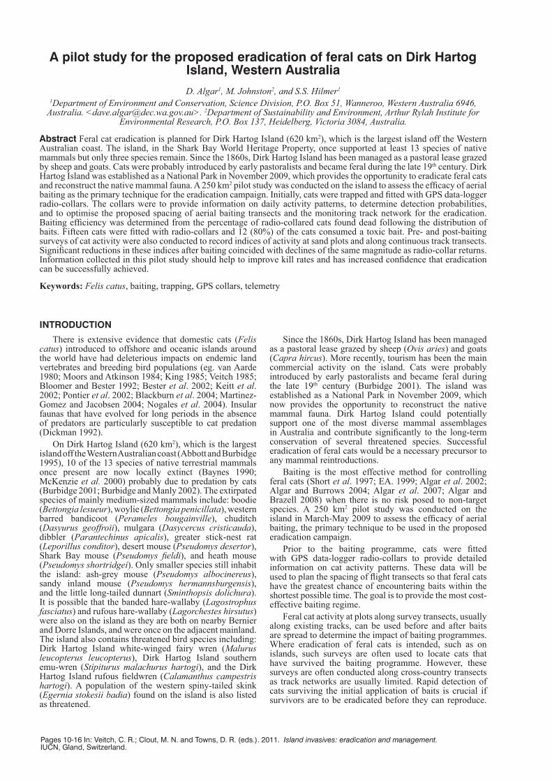
Four track survey transects (i.e. spatial replicates) were established across the site. Each transect was 10 km in length along existing tracks and these provided a broad coverage of the entire area. Transects were separated by approximately 5 km to ensure independence. Twenty marked sand plots, positioned across the width of the tracks and located at 0.5 km intervals along each transect, were used to survey feral cat activity (Fig. 2). An audio lure (Felid Attracting Phonic, Westcare Industries, Western Australia) and an olfactory lure (Cat-astrophic, Outfoxed, Victoria) were used to attract cats to the sand plots during the two survey periods. The audio lure was concealed within a bush at the rear of the sand plot and the olfactory lure was presented on cotton wool tied to the vegetation. Both lures were removed outside the survey periods. Vehicle traffic and the limited access to the south of the study area precluded monitoring similar transects in a control (non-baited) site.
Each plot was observed for the presence or absence of tracks, as it was not possible to determine the number of intrusions by individual animals onto the plot. The plots were swept daily to clear evidence of previous activity. Cat activity at the sand plots was recorded over five consecutive nights during two survey periods to generate a Plot Activity
Index (PAI). This index is expressed as the mean number of sand plots visited by the target species per night. The PAI is formed by calculating an overall mean from the daily means (Engeman et al. 1998; Engeman 2005). The VARCOMP procedure within the SAS statistical software package produced the variance component estimates.
The survey tracks had a sandy surface substrate that also enabled the use of a continuous ‘Track Count Index’ (TCI) to monitor daily activity along the length of the four transects. Imprints of individual animals were differentiated on the basis of location on the transect. An imprint was assigned to an individual animal if no other imprint was present on at least the previous 1 km of transect. Subsequent imprints were also assigned to that individual unless at least 1 km was traversed with no new imprints present, or the imprint could be clearly differentiated on the basis of size or the direction of travel or the direction of entry/exit to and from the transect. Each time new cat tracks were encountered along the transect, information was recorded on the direction of movement (i.e. whether the animal walked along the track or crossed it), distance of the tracks from the start of the transect, and whether more than one animal was present. Data were also noted on the distance that the tracks remained on the transect. Track counts were conducted from ATVs driven at a speed of <10 km h-1. Transects were swept on the return journey using a section of heavy conveyer rubber and chains towed behind the ATV. The total number of cats was summed over the sampling days for each transect and the TCI was the transect mean expressed as the number of cats/10 km of transect.
Comparison of the indices pre- and post- baiting were analysed using a ‘z’-test (for sample sizes greater than 30 i.e. PAI data) or the ‘t’- test (for samples less than 30, i.e. TCI data) (Elzinga et al. 2001).
Baits and baiting programmeThe feral cat bait (Eradicat) (see detailed description in
Algar and Burrows 2004; Algar et al. 2007) can effectively reduce cat numbers (Algar et al. 2002; Algar and Burrows 2004; Algar et al. 2007).The baits contain 4.5 mg of directly injected toxin ‘1080’ (sodium monofluoroacetate). In addition, 3600 baits were manually implanted with a Rhodamine B ‘Hard Shell Delivery Vehicle’ (HSDV) made available as a part of a separate study (Johnston et al. 2010; Johnston et al. 2011). Rhodamine B is an efficient systemic biomarker for determining bait consumption by feral cats and a wide range of non-target species (Fisher 1998). When Rhodamine B is consumed, the compound causes short-term staining of body tissues, digestive and faecal material with which it comes in contact.
To optimise efficacy, the baiting campaign needed to be conducted before late autumn/winter rainfall began in May (long term Bureau of Meteorology data). On 19 April, a dedicated baiting aircraft dropped the baits at previously designated bait drop points (Johnston et al. 2010). The baiting aircraft flew at a nominal speed of 130 kt and 500 ft (Above Ground Level) and a GPS point was recorded on the flight plan each time bait left the aircraft. The bombardier released a bag of 50 baits into each 1 km map grid, along flight transects 1 km apart, to achieve an application rate of 50 baits km-2 (Fig. 3). Baits containing the Rhodamine B HSDVs were strategically dropped into the map grids immediately surrounding the locations of the collared cats. All other areas were baited with conventional Eradicat baits (i.e. without the Rhodamine B HSDV). The ground spread of 50 baits is approximately 250 x 150 m (D. Algar unpub. data). The Western Australian guidelines for use of 1080 baits provides for ‘Bait Exclusion Zones’
Fig. 2 Location of transects (T1-4) and monitoring plots.

13
of 500 m radius at and around sites subject to high human visitation. No baits were applied to seven such sites within the study area (Fig. 3).
Immediately before baiting, locations were plotted from fixes obtained from an aircraft for all but one of the collared cats (Fig. 3). Daily monitoring of radio-collared cats was undertaken from 21 April, using either a handheld yagi antenna or a vehicle mounted omni-direction antenna connected to a VHF receiver. The death of cats was indicated by a change in pulse rate from the collars, as it switched to mortality mode following 24 hours of no movement.
Additional Eradicat baits were laid by hand in the vicinity of all collared cats that were still alive on 27 April. Cats surviving till 1 May were located using radio telemetry and shot to recover the GPS data-logger collars.
RESULTS
Cat trapping and radio-collaring Twenty-one cats were trapped, comprising 13 males
and eight females (Table 1). Seventeen cats were trapped on the coastal tracks and four along the central track, where cat activity appeared lower. Bodyweight (mean ± s.e.) for
males was 4.3 ± 0.3 kg and 2.9 ± 0.3 kg for females. Sixteen radio-collars were available; five cats were released without a collar, four of which were under the established collar to body mass ratio (> 2.1 kg). All cats were in excellent body condition, with large deposits of body fat.
A compilation of all location data obtained from the data-logger collars is presented in Fig. 4. Analysis of daily movement patterns, pooled for all cats, indicates that the time (mean ± s.e.) to encounter transect lines spaced at 500, 1000, 1500 and 2000 m was 1.0 ± 0.2, 1.8 ± 0.5, 4.6 ± 1.1 and 12.2 ± 3.2 days respectively. The time to cross
Fig. 3 Pattern of bait distribution, and locations of collared feral cats on the day of baiting. Note that cat B1, outside the baited zone, was found dead before the baiting, cause of death is unknown. Cat DH29 was not located from aircraft, and therefore it is missing from the map.
Table 1 Morphological details and GPS data-logger collar activity period for feral cats trapped on Dirk Hartog Island.
Cat ID Number of days to be 95% sure of detecting cat at transect spacings
500 m 1000 m 1500 m 2000 mB2 0.5 1.5 6.5 8.6B3 1.0 1.0 1.7 10.6DH5 0.4 0.4 12.6 14.8DH5_1 0.5 0.6 8.5 11.5DH12 0.5 0.6 0.6 0.7DH17 0.9 5.5 5.9 9.7DH27 1.5 1.5 1.7 2.4DH27_2 0.1 1.0 3.7 3.8DH29 2.5 6.5 6.6 12.6MB2 0.6 0.6 1.5 5.6MB3 0.9 1.9 1.9 18.5MB5 0.5 0.6 0.8 >40MB6 1.5 1.6 13.0 >40MB7 2.8 3.5 3.5 3.7MB8 0.5 0.7 0.7 0.8mean ± s.e. 1.0 ± 0.2 1.8 ± 0.5 4.6 ± 1.1 12.2 ± 3.2
Cat No. Sex (M/F)
Weight (kg)
Data-logger activity period(GPS sampling frequency )
B1 M 3.8 25 March – 19 April (80 mins)B2 F 3.5 29 March – 18 April (10mins)B3 F 3.7 29 March – 24 April (10 mins)B5 M 1.5 Not collaredDH5 M 5.1 28 March – 20 April (10 mins)DH5_1 M 4.2 28March – 16 April (10 mins)DH8 F 2.0 Not collaredDH12 M 5.0 28 March – 15 April (10 mins)DH17 M 5.0 28 March – 23 April (10 mins)DH26 F 2.0 Not collaredDH27 M 5.1 30 March – 8 May (40 mins)DH27_2 M 4.5 31 March – 21 April (40 mins)DH29 M 4.7 30 March – 7 May (80 mins)MB1 F 1.8 Not collaredMB2 M 3.2 29 March – 22 April (80 mins)MB3 M 3.2 25 March – 22 April (80 mins)MB4 F 2.7 Not collaredMB5 F 3.7 28 March – 10 April (10 mins)MB6 M 4.7 28 March – 18 April (80 mins)MB7 F 3.5 29 March – 21 April (80 mins)MB8 M 5.5 27 March – 8 April (10 mins)
Table 2 The time to encounter transect lines spaced at 500, 1000, 1500 and 2000 m for individual cats.
Algar et al.: Eradication of cats, Dirk Hartog I.

Island invasives: eradication and management
14
a transect for individual cats is presented in Table 2. Two cats, MB5 and MB6, had a low likelihood of being detected at all on the 2000 m spacing (7.5% and 18% respectively).
Impact of baiting programmeWhen baits were spread on 19 April, 15 collared cats
were known to be alive. A GPS data-logger on cat (B1) indicated that it moved out of the study area and died before baits were applied. Ten collared cats died after consuming aerially delivered Eradicat baits and nine of these had Rhodamine B stains throughout their gastro-intestinal tracts. The tenth animal did not show any Rhodamine B stains but displayed typical symptoms of death from 1080 poisoning. It is not possible to determine whether this cat moved out of the zone where baits containing the Rhodamine B HSDV had been applied or rejected it during feeding as the collar had ceased collecting data. Cats B2 and B3 died following consumption of Eradicat bait(s), probably as a result of baits that were distributed by hand in their vicinity on 27 April. The mortality signal from both
collars activated 24 hours after bait application by hand and both carcases indicated 1080 toxicoses. In total, 80% of the radio-collared feral cats consumed a toxic bait. Cats DH27, DH29 and MB8 were shot to recover their collars after they had not consumed baits by 1 May (i.e. 12 days post aerial baiting). Bait consumption was highest the day following bait application. However, aerially deployed baits remained palatable to some animals at least ten days following application, given that cat DH17 consumed a bait on 29 April.
Surveys of cat activityIndices of activity declined following bait application at
similar magnitude to radio-collar returns. Compared with values before bait application, PAIs were 83% lower after baiting (z = 3.27, P < 0.001), with PAIs (mean ± s.e.) of 0.079 ± 0.019 and 0.013 ± 0.006 recorded for pre- and post-bait surveys respectively. Similarly, there was a significant difference (t = 6.96, P < 0.001) in the TCIs following baiting with >90% reduction recorded. TCIs pooled over
Fig. 4 Compilation of all data (HDOP > 10) derived from GPS data-logger collars fitted to feral cats between 25 March and 5 May 2009. Two maps were necessary due to the high overlap of individual cats.

15
transects recorded 2.75 ± 0.34 cats/10 km transect prior to baiting and 0.25 ± 0.09 cats/10 km transect following baiting.
DISCUSSION
The trial indicated that 10/15 cats died after the aerial spread of baits and a further two animals died after eating baits distributed by hand. Furthermore, reduced indices of activity indicated >80% of the feral cat population died following bait consumption. Our results demonstrate that Eradicat baits spread by air will be effective as the primary knock down technique for an eradication campaign on Dirk Hartog Island. During this study, prey for cats appeared plentiful; an abundant rodent population likely related to significant rainfall events over the past two years. Additionally, several collared cats were also implicated in predation of loggerhead turtle (Caretta caretta) hatchlings (Hilmer et al. 2010). Even greater baiting efficacy might have been achieved when prey was less abundant as optimal rates of bait consumption by feral cats are achieved during periods of food stress (Short et al. 1997; Algar et al. 2007). The actual eradication will be timed for a period of minimal prey availability.
Bait consumption is not only a function of their attractiveness and palatability but also their accessibility (Algar et al. 2007). All cats in this study should have had some opportunity to encounter baits given the baiting intensity and pattern flown by the aircraft. Despite being opportunistic predators, cats will only consume a food item if they are hungry (Bradshaw 1992); if a bait is encountered when the animal is not hungry it may not be consumed regardless of the attractiveness of the bait. Therefore baiting intensity and distribution pattern as well as bait longevity are critical components of successful baiting campaigns. Increasing baiting intensity beyond 50 baits km-2 along 1.0 km flight path widths will not necessarily improve baiting efficacy (Algar and Burrows 2004). Analysis of daily cat movement patterns on the island and encounter rates for various transect spacings suggest that reducing flight path spacing to 0.5 km may result in increased bait encounter, particularly in the short-term and may put more cats at risk. Cats B2 and B3 were presumed to have consumed baits applied by hand on 27 April given their patterns of behaviour in the period following application of aerial baits (they were readily located in similar positions during daily checks between the 21 and 27 April). The home ranges inhabited by these cats, in particular B3, were centrally located between aerial bait transects and as a result these animals had less opportunities to encounter a bait. These cats would have encountered baits more often if the flight lines were at intervals of 0.5 km rather than 1.0 km.
All three cats that survived the baiting campaign were in excellent body condition and were obviously not food stressed. Two of these animals occupied/patrolled beaches while the remaining cat probably used other food sources as it was not thought to be accessing beaches where turtle hatchlings were available. All three animals frequented one or more ‘bait exclusion zones’ but also spent time where baits were present. The proposed eradication plan will seek exemption from the requirement to establish ‘bait exclusion zones’, as these may provide a bait-free refuge for cats, particularly those with small home ranges such as juveniles and sub-adults.
Our activity data were biased towards heavier animals, because collars could not be fitted to cats <2.1 kg in weight. The fate of juvenile and sub-adult feral cats following application of baits is thus difficult to assess. GPS data-logger collars were fitted to a larger number of male cats
than females for the same reason. Smaller, lighter weight GPS data-logger/radio-telemetry collar are likely to be available in the near future. We proposed to fit these collars to juvenile/sub-adult cats before the eradication programme to test whether our existing strategy places smaller cats at risk. If the collars are still unavailable prior to baiting, this group of cats will be fitted with VHF radio-collars and their survival/mortality monitored following baiting. All animals within the population should be targeted in the eradication programme. The modifications proposed to the current baiting regime should maximise the likelihood of the entire cat population encountering baits.
Most cat ranges were coastal or near-coastal and prey appeared more abundant in these areas. To compensate for this apparent uneven distribution of cats we propose to provide additional baits in more complex topography such as that around the coast.
Baiting alone is unlikely to eradicate the feral cats, so an intensive monitoring and trapping campaign will also be conducted to remove survivors. Placement of monitoring transects will strike a balance between limiting vegetation disturbance and erosion and optimising cat encounters during proposed survey periods of two weeks duration each month. Cat movement data suggest that monitoring transects 1.5 to 2.0 km apart would be sufficient to enable detection of adult animals within each survey period. Data obtained from radio-collared juveniles/sub-adult cats before the eradication programme will verify the suitability of this transect placement across the population.
The size of the island, in particular its length, poses logistical constraints to simultaneous eradication across the entire island. Because it is not practical or feasible to monitor cat activity over such a large area, we propose to conduct the eradication campaign in two stages over three years from January 2011 – January 2014. The first year would be dedicated to installing infrastructure including monitoring transects and an east-west cat-proof barrier fence. We then propose to conduct the baiting and follow-up monitoring/trapping programme against feral cats from the southern fenced section in 2012. This will be followed by the same exercise in the northern fenced section in 2013.
The estimated cost of the feral cat eradication and independent confirmation of success is AUD 2,000,000 excluding salaries over the three year period. Globally, the Dirk Hartog project could become the largest island from which feral cats have been eradicated.
ACKNOWLEDGEMENTS
Additional field assistance was provided by Mike Onus, Neil Hamilton, Bruce Withnell, Katrin Koch, David Hawke and Steve Virgin of the WA Department of Conservation and Environment (DEC). We would like to thank staff at the DEC Denham office especially Brett Fitzgerald, and Keiran Wardle and Sandra Wilkens (Dirk Hartog Island Lodge) who assisted with logistics during the study. Advice regarding manipulation of GIS data was sourced from Matt White (DSE), Rob Doria (DEC) and Tony Buckmaster (University of Sydney). Statistical analysis of the movement data was conducted by Andrew Gormley (DSE). Finally, we gratefully acknowledge the financial support and encouragement from Julie Quinn (Department of the Environment, Water, Heritage and the Arts). This manuscript was improved following comments from two anonymous referees. The DEC Animal Ethics Committee approved protocols 2006/06 and 2008/29 which describe activities undertaken in this project. Prior to the
Algar et al.: Eradication of cats, Dirk Hartog I.

Island invasives: eradication and management
16
baiting programme a DEC “1080 Risk Assessment” was undertaken, and approval from the Australian Pesticides and Veterinary Medicine Authority granted (Permit Number 10634v4).
REFERENCESAbbott, I. and Burbidge, A.A. 1995. The occurrence of mammal
species on the islands of Australia: a summary of existing knowledge. CALMScience 1(3): 259-324.
Algar, D. and Brazell, R.I. 2008. A bait suspension device for the control of feral cats. Wildlife Research 35: 471-476.
Algar, D. and Burrows, N.D. 2004. A review of Western Shield: feral cat control research. Conservation Science Western Australia 5(2): 131-163.
Algar, D.; Burbidge, A.A. and Angus, G.J. 2002. Cat Eradication on the Montebello Islands. In: Veitch, C.R. and Clout, M.N. (eds.). Turning the tide: the eradication of invasive species, pp. 14-18. IUCN, SSC, Invasive Species Specialist Group, IUCN, Gland, Switzerland and Cambridge, U.K.
Algar, D.; Angus, G.J.; Williams, M.R. and Mellican, A.E. 2007. Influence of bait type, weather and prey abundance on bait uptake by feral cats (Felis catus) on Peron Peninsula, Western Australia. Conservation Science Western Australia 6(1): 109-149.
Baynes, A. 1990. The mammals of Shark Bay, Western Australia. In: Berry, P.F.; Bradshaw, S.D. and Wilson, B.R. (eds.). Research in Shark Bay – Report of the France-Australe Bicentenary Expedition Committee, pp. 313-325. Western Australian Museum, Perth, Australia.
Beard, J. 1976. Vegetation Survey of Western Australia, Sheet 6. 1:1 000 000 Map Sheet and Explanatory Notes. UWA Press, Perth, Australia.
Bester, M.N.; Bloomer, J.P.; van Aarde, R.J.; Erasmus, B.H.; van Rensburg, P.J.J; Skinner, J.D.; Howell, P.G. and Naude, T.W. 2002. A review of the successful eradication of feral cats from sub-Antarctic Marion Island, Southern Indian Ocean. South African Journal of Wildlife Research 32(1): 65-73.
Blackburn, T.M.; Cassey, P.; Duncan, R.P.; Evans, K.L. and Gaston, K.J. 2004. Avian extinction and mammalian introductions on oceanic islands. Science 305: 1955-1958.
Bloomer, J.P. and Bester, M.N. 1992. Control of feral cats on sub-Antarctic Marion Island, Indian Ocean. Biological Conservation 60: 211-219.
Bradshaw, J.W.S. 1992. The Behaviour of the Domestic Cat. CAB International, Wallingford, Oxon, U.K.
Burbidge, A. 2001. Our largest island. Landscope 17(2): 16-22.
Burbidge, A.A. and Manly, B.F.J. 2002. Mammal extinctions on Australian islands: causes and conservation implications. Journal of Biogeography 29: 465-473.
Dickman, C.R. 1992. Conservation of mammals in the Australasian region: the importance of islands. In: Coles, J.N. and Drew, J.M. (eds.). Australia and the Global Environmental Crisis, pp. 175-214. Academy Press, Canberra, Australia.
EA (Environment Australia) 1999. Threat Abatement Plan for predation by feral cats. Environment Australia, Biodiversity Group, Canberra, Australia.
Engeman, R.M. 2005. Indexing principles and a widely applicable paradigm for indexing animal populations. Wildlife Research 32: 203-210.
Engeman, R.M.; Allen, L. and Zerbe, G.O. 1998. Variance estimate for the Allen activity index. Wildlife Research 25: 643-648.
Elzinga, C.L., Salzer, D.W., Willougby, J.W. and Gibbs, J.P. 2001. Monitoring Plant and Animal Populations. Blackwell Science Inc. USA.
Fisher, P. 1998. Rhodamine B as a marker for the assessment of non-toxic bait uptake by animals. Vertebrate Pest Research Unit, Department of Natural Resources and Environment. Technical Series No. 4.
Hilmer, S.S. 2010. Ecophysiology of feral cats (Felis catus) in Australia. PhD thesis, Johann-Goethe University, Frankfurt, Germany.
Hilmer S.S.; Algar D. and Johnston M. 2010. Opportunistic observation of predation of loggerhead turtle hatchlings by feral cats on Dirk Hartog Island, Western Australia. Journal of the Royal Society of Western Australia 93: 141-146.
Johnston, M.; Algar, D.; O’Donoghue, M. and Morris, J. 2011. Field efficacy of the Curiosity feral cat bait on three Australian islands. In: Veitch, C. R.; Clout, M. N. and Towns, D. R. (eds.). 2011. Island invasives: eradication and management, pp. 182-187. IUCN, Gland, Switzerland.
Johnston, M.; Algar, D.; Onus, M.; Hamilton, N.; Hilmer, S.; Withnell, B. and Koch, K. 2010. A bait efficacy trial for the management of feral cats on Dirk Hartog Island. Arthur Rylah Institute for Environmental Research. Technical Report Series 205. Department of Sustainability and Environment, VIC, Australia.
Keitt, B.S.; Wilcox, C.; Tershy, B.R.; Croll, D.A. and Donlan, C.J. 2002. The effect of feral cats on the population viability of black-vented shearwaters (Puffinus opisthomelas) on Natividad Island, Mexico. Animal Conservation 5: 217-223.
King, W.B. 1985. Island birds: will the future repeat the past? In: Moors, P.J. (ed.). Conservation of Island Birds, pp. 3-15. ICBP Technical Publication No. 3.
Martinez-Gomez, J.E. and Jacobsen, J.K. 2004. The conservation status of Townsend’s shearwater Puffinus auricularis auricularis. Biological Conservation 116: 35-47.
McKenzie, N.L.; Hall, N. and Muir, W.P. 2000. Non-volant mammals of the southern Carnarvon Basin, Western Australia. Records of the Western Australian Museum Supplement No. 61: 479-510.
Moors, P.J. and Atkinson, I.A.E. 1984. Predation on seabirds by introduced animals, and factors affecting its severity. In: Croxall, J.P.; Evans, P.J.H. and Schreiber, R.W. (eds.). Status and Conservation of the World’s Seabirds, pp. 667-90. ICBP Technical Publication No. 2.
Moseby K.E.; Stott J. and Crisp H. 2009. Movement patterns of feral predators in an arid environment-implication for control through poison baiting. Wildlife Research 36: 422-435.
Nogales, M.; Martin, A.; Tershy, B.R.; Donlan, C.J.; Veitch, D.; Puerta, N.; Wood, B. and Alonso, J. 2004. A review of feral domestic cat eradication on islands. Conservation Biology 18(2): 310-319.
Payne, A.; Curry, P. and Spencer, G. 1987. An inventory and condition survey of rangelands in the Carnarvon Basin, Western Australia. Technical Bulletin No73. Western Australian Department of Agriculture, Perth, Australia.
Pontier, D.; Say, L.; Debias, F.; Bried, J.; Thioulouse, J.; Micol, T. and Natoli, E. 2002. The diet of cats (Felis catus L.) at five sites on the Grande Terre, Kerguelen archipelago. Polar Biology 25: 833-837.
R Development Core Team 2009. R: A language and environment for statistical computing. R Foundation for Statistical Computing, Vienna, Austria. ISBN 3-900051-07-0, http://www.R-project.org.
Short, J.; Turner, B.; Risbey, D.A. and Carnamah, R. 1997. Control of feral cats for nature conservation. II. Population reduction by poisoning. Wildlife Research 24: 703-714.
van Aarde, R.J. 1980. The diet and feeding behaviour of feral cats, Felis catus, on Marion Island. South African Journal of Wildlife Research 10: 123-128.
Veitch, C.R. 1985. Methods of eradicating feral cats from offshore islands in New Zealand. In: Moors, P.J. (ed.). Conservation of Island Birds, pp. 125-141. ICBP Technical Publication No. 3.