a geosemantic proximity-based prototype for the...
TRANSCRIPT

Computers, Environment and Urban Systems
29 (2005) 669–698
www.elsevier.com/locate/compenvurbsys
A geosemantic proximity-based prototypefor the interoperability of geospatial data
Jean Brodeur a,*,1, Yvan Bedard b,1, Bernard Moulin c,1
a Centre for Topographic Information, Natural Resources Canada, 2144 King Street West,
Sherbrooke (QC), Canada JIJ 2E8b Department of Geomatics Sciences, Pavillon Casault, Universite Laval, Que., Canada G1K 7P4c Department of Computer Science, Pavillon Pouliot, Universite Laval, Que., Canada G1K 7P4
Received 19 June 2003; accepted in revised form 21 April 2004
Abstract
The research agenda related to the interoperability of geospatial data is influenced by the
increased accessibility of geospatial databases on the Internet, as well as their sharing and their
integration. Although it is now possible to get and use geospatial data independently of their
syntax and structure, it is still difficult for users to find the exact data they need as long as they
do not know the precise vocabulary used by the organizations supporting geospatial dat-
abases. It is now a necessity to take into consideration the semantics of geospatial data to
enable its full interoperability.
To this end, we designed a new conceptual framework for geospatial data interoperability
and introduced the notion of geosemantic proximity based on human communication and cog-
nition paradigms. This paper reviews this framework and the notion of geosemantic proximity.
It also presents the GsP Prototype, which demonstrates the relevance of our framework and of
the notion of geosemantic proximity for geospatial data interoperability. More specifically, we
describe the architecture of the GsP Prototype, its implementation, and tests that have been
conducted.
� 2004 Elsevier Ltd. All rights reserved.
0198-9715/$ - see front matter � 2004 Elsevier Ltd. All rights reserved.
doi:10.1016/j.compenvurbsys.2004.04.001
* Corresponding author. Fax: +1 819 564 5698.
E-mail address: [email protected] (J. Brodeur).1 Also at Centre for Research in Geomatics (CRG).

670 J. Brodeur et al. / Comput., Environ. and Urban Systems 29 (2005) 669–698
1. Introduction
Many geospatial databases have been set up during the last twenty years by dif-
ferent organizations to establish information bases corresponding to their specific
needs. In this respect, the National Topographic Data Base (NTDB) (Natural Re-sources Canada, 1996) was elaborated for national mapping and GIS application
purposes in Canada. Also, the VMap libraries (VMap, 1995) that also include topo-
graphic features of Canada were developed for military purposes. Moreover, Statis-
tics Canada established the Street Network Files and the Digital Cartographic Files
for socio-demographic and enumeration purposes (Statistics Canada, 1997). Addi-
tional topographic data sources produced at larger scales by provincial departments
(e.g. OBM, 1996; Quebec, 2000) are also other Canadian geospatial database exam-
ples. Each of these examples describes topographic features in different manners. Toillustrate this, we have observed that forest-like phenomena are abstracted as vege-
tation in NTDB, trees in VMap, woodedarea in Ontario Digital Topographic
Data Base, and milieu boise in the Base de donnees topographiques du Quebec
(where the pictograms point out the type of geometry used to map the feature geom-
etry: point/ , line/ , or polygon/ ; see (Bedard & Proulx, 2002) for the description of
spatial pictograms).
Since these organizations found that their respective databases are of general
interest, they made them available to the public. Today, the Internet, the Web,and geospatial data infrastructures such as the Canadian Geospatial Data Infra-
structure (CGDI) (GeoConnections, 2002) and the National Spatial Data Infrastruc-
ture (NSDI) (FGDC, 2002) facilitate the access to these geospatial databases.
Because users have access to several topographic databases, they expect to find,
get and integrate the exact data they need from various databases according to their
own perception and abstraction of the topographic reality. Hence, such a situation
raises problems of syntactic, structural, semantic, geometric, and temporal heteroge-
neities between geospatial databases (Bishr, 1997; Charron, 1995; Laurini, 1998;Ouksel & Sheth, 1999; Sheth, 1999).
The idea of interoperability of geospatial databases has been promoted in the
nineties to overcome the above mentioned heterogeneity problems and to allow
the sharing and the integration of geospatial data and geospatial resources (Kott-
man, 1999). The current basis of geospatial data interoperability has been worked
out by organizations such as the Open GIS Consortium Inc. (OGC), ISO/TC 211,
governmental organizations, the geographic information industry and the geo-
graphic information academic community. They have made considerable progressparticularly with regards to syntactic and structural heterogeneities (Egenhofer,
1999; Ouksel & Sheth, 1999; Rodriguez, 2000). Documents such as (ISO/TC 211,
2003a, 2003b; Open GIS Consortium Inc., 1999, 2001) define the content and the
structure of geometric data as well as the syntactical description of geospatial data.
But, to enable complete interoperability of geospatial data, it is essential to go be-
yond structural and syntactic heterogeneities and to address semantic heterogeneities
as well as geometric and temporal heterogeneities (Egenhofer, 1999; Ouksel & Sheth,
1999).

J. Brodeur et al. / Comput., Environ. and Urban Systems 29 (2005) 669–698 671
Recently, we proposed a conceptual framework for geospatial data interoperabil-
ity based on an analogy with human communication and have also introduced the
notion of geosemantic proximity (GsP) (Brodeur, 2004; Brodeur & Bedard, 2001;
Brodeur, Bedard, Edwards, & Moulin, 2003) as a solution to problems of semantic,
spatial, and temporal heterogeneities of geospatial data. We also developed an exper-imental prototype, called GsP Prototype, to validate both our conceptual framework
for geospatial data interoperability and the notion of geosemantic proximity. This
paper specifically aims at presenting this prototype and the experiments we have
conducted.
The remaining sections of this paper are structured as follows. The next section
reviews geospatial data interoperability in the context of the communication process,
the notion of geosemantic proximity, and the notion of a geospatial repository, which
serve as the agent�s application ontologies (Gruber, 1993; Guarino & Welty, 2000) inthe prototype. In Section 3, we present the GsP Prototype, its architecture, its oper-
ation, and tests. We conclude and present future work in Section 4.
2. Geospatial data interoperability
During the last decade, interoperability has been developed within the OGC con-
text as heterogeneous software components and Web services that adhere to com-mon interface definitions. These components are assembled and operate together
like a single system, transparently to users, even if they are located in a distributed
environment (McKee & Buehler, 1998; Sondheim, Gardels, & Buehler, 1999). On the
other hand, the Institute of Electrical and Electronics Engineers (IEEE) defined
interoperability as the ability of two or more components to exchange information
and to use the information that has been exchanged (Institute of Electrical & Elec-
tronics Engineers, 1990). This second definition emphasizes the ability of interpreting
data across systems (Renner, 2001). Interoperability, and more specifically semanticinteroperability, has to go beyond the delivery of data between systems that are
interconnected to each other using common interfaces by providing reasoning capa-
bilities to enable semantic interactions between systems (Kuhn, 2000). Accordingly,
interoperability of geospatial data is presented hereafter in the spirit of the IEEE def-
inition, in which geospatial concepts have reasoning capabilities that increase the
ability of information systems and services to work in co-operation without human
intervention (Kuhn, 2003). Our approach uses ontologies to enable agents to reason
about information required by another agent and, as such, follows the idea of Ontol-
ogy-Driven Geographic Information Systems (ODGIS) (Fonseca & Egenhofer, 1999;
Fonseca, Egenhofer, Davis, & Borges, 2000).
2.1. A communication account of interoperability
Because people usually understand each other when communicating, we suggested
that interoperability of geospatial data conforms to a human communication process
(Brodeur et al., 2003). Harvey (2002), Xhu and Lee (2002), and Uitermark, van

672 J. Brodeur et al. / Comput., Environ. and Urban Systems 29 (2005) 669–698
Oosterom, Mars, and Molenaar (1999) also support this idea. As such, we developed
a conceptual framework for geospatial data interoperability as a human-like com-
munication process. In this section, we review our conceptual framework for geospa-
tial data interoperability, which is the foundation of the architecture of the prototype
presented in the next section.According to Schramm (1971), a human communication process involves a
source, a message, and a destination. When the source transmits information to
the destination, he/she encodes a message, that is, to identify the information to
be communicated and to transform it into physical signals. At this point, the message
is still tied to the source�s meaning. Afterwards, the source releases the message in
the communication channel towards destination. Then, the message is released from
the source�s meaning. The message plays a mediating role between the source and the
destination. When the message arrives at its destination, the destination begins to de-code it. It recognizes the signals that compose it and assigns them a specific meaning.
The communication process is working perfectly when the source�s meaning and the
destination�s meaning of the message are the same. However, a possible source of
noise can interfere with message�s signals in the communication process and affect
the transmission of the message. On the other hand, the communication process in-
cludes a feedback mechanism, which acts as a function to check how well the com-
munication is performed. For instance, feedback may inform the source whether the
destination has understood the message properly. As we can see, multiple represen-tations of reality take place in the human communication process, namely the
source�s and destination�s cognitive models, and the physical signals used for the
message transmission. In the communication process, by definition the source and
the destination succeed in exchanging information when they interoperate with each
other.
The source�s and destination�s cognitive models result from the direct and the
indirect observation (e.g. through sensors such as Earth observation satellite or aer-
ial digital camera) of real-world phenomena and intentionally-produced signalsreceived from other people. Human sensory systems capture signals and form so-
called perceptual states (Barsalou, 1999). From perceptual states, the human selective
attention collects the properties of interest and records them permanently as percep-
tual symbols, also known as concepts (Barsalou, 1999). As a cognitive element, a con-
cept can never be accessed directly by another individual. It must be translated into
physical signals, here called conceptual representations, in order to be communicated.
A concept consists therefore of hidden-like data elements and a translation function
that encapsulates these data elements. This translation function operates in twodirections: (1) to generate conceptual representations when one wants to send a mes-
sage and (2) to recognize conceptual representations when one wants to understand a
received message.
Based on the human communication process, we developed a conceptual frame-
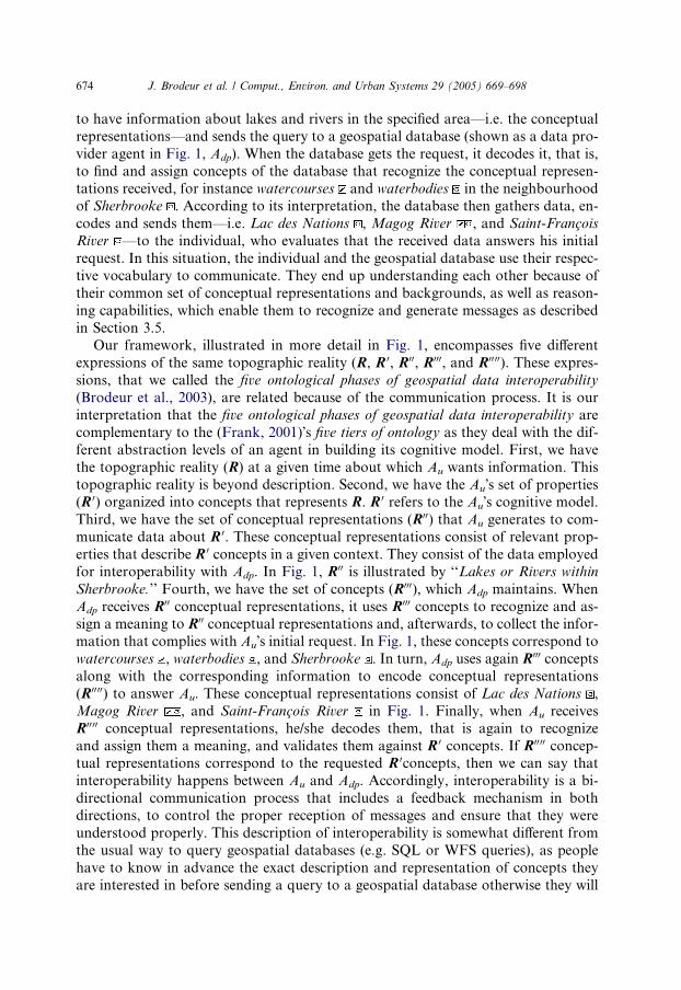
work for geospatial data interoperability (Fig. 1) (Brodeur et al., 2003). Let us use
the following situation to explain our framework. An individual (shown as a user
agent in Fig. 1, Au) wants information about the hydrologic network for flood anal-
ysis within a predefined area of the city of Sherbrooke. He/she encodes a query

Fig. 1. A framework for spatial data interoperability (Brodeur et al., 2003).
J.Brodeuret
al./Comput.,
Enviro
n.andUrbanSystem
s29(2005)669–698
673
674 J. Brodeur et al. / Comput., Environ. and Urban Systems 29 (2005) 669–698
to have information about lakes and rivers in the specified area––i.e. the conceptual
representations––and sends the query to a geospatial database (shown as a data pro-
vider agent in Fig. 1, Adp). When the database gets the request, it decodes it, that is,
to find and assign concepts of the database that recognize the conceptual represen-
tations received, for instance watercourses and waterbodies in the neighbourhoodof Sherbrooke . According to its interpretation, the database then gathers data, en-
codes and sends them––i.e. Lac des Nations , Magog River , and Saint-Francois
River ––to the individual, who evaluates that the received data answers his initial
request. In this situation, the individual and the geospatial database use their respec-
tive vocabulary to communicate. They end up understanding each other because of
their common set of conceptual representations and backgrounds, as well as reason-
ing capabilities, which enable them to recognize and generate messages as described
in Section 3.5.Our framework, illustrated in more detail in Fig. 1, encompasses five different
expressions of the same topographic reality (R, R 0, R00, R000, and R00 00). These expres-
sions, that we called the five ontological phases of geospatial data interoperability
(Brodeur et al., 2003), are related because of the communication process. It is our
interpretation that the five ontological phases of geospatial data interoperability are
complementary to the (Frank, 2001)�s five tiers of ontology as they deal with the dif-
ferent abstraction levels of an agent in building its cognitive model. First, we have
the topographic reality (R) at a given time about which Au wants information. Thistopographic reality is beyond description. Second, we have the Au�s set of properties(R 0) organized into concepts that represents R. R 0 refers to the Au�s cognitive model.
Third, we have the set of conceptual representations (R00) that Au generates to com-
municate data about R 0. These conceptual representations consist of relevant prop-
erties that describe R 0 concepts in a given context. They consist of the data employed
for interoperability with Adp. In Fig. 1, R00 is illustrated by ‘‘Lakes or Rivers within
Sherbrooke.’’ Fourth, we have the set of concepts (R000), which Adp maintains. When
Adp receives R00 conceptual representations, it uses R000 concepts to recognize and as-
sign a meaning to R00 conceptual representations and, afterwards, to collect the infor-
mation that complies with Au�s initial request. In Fig. 1, these concepts correspond to
watercourses , waterbodies , and Sherbrooke . In turn, Adp uses again R000 concepts
along with the corresponding information to encode conceptual representations
(R0000) to answer Au. These conceptual representations consist of Lac des Nations ,
Magog River , and Saint-Francois River in Fig. 1. Finally, when Au receives
R00 00 conceptual representations, he/she decodes them, that is again to recognize
and assign them a meaning, and validates them against R 0 concepts. If R00 00 concep-tual representations correspond to the requested R 0concepts, then we can say that
interoperability happens between Au and Adp. Accordingly, interoperability is a bi-
directional communication process that includes a feedback mechanism in both
directions, to control the proper reception of messages and ensure that they were
understood properly. This description of interoperability is somewhat different from
the usual way to query geospatial databases (e.g. SQL or WFS queries), as people
have to know in advance the exact description and representation of concepts they
are interested in before sending a query to a geospatial database otherwise they will

J. Brodeur et al. / Comput., Environ. and Urban Systems 29 (2005) 669–698 675
not get any data. From a GIS and a database perspective, we believe that this com-
munication-based conceptual framework, which takes into consideration the seman-
tic issue, allows further progress towards the resolution of the geospatial data access
issue.
As mentioned previously, R, R 0, R00, R000, and R0000 consist in different facets of thereality which are concerned about ontology, even if they have similarities. In philos-
ophy, ontology is a subject matter dealing with:
• the description of the world (Peuquet, Smith, & Brogaard, 1998);
• a model and an abstract theory of the world (Smith & Mark, 1999);
• the science of being (Bittner & Edwards, 2001; Peuquet et al., 1998);
• the science of the type of entities, of the objects, of the properties, of the catego-
ries, and of relationships, which constitute the world (Lehmann, 1992; Peuquetet al., 1998; Smith & Mark, 1999).
Ontology is also a subject of interest in artificial intelligence and database. It has
been defined by (Gruber, 1993) as ‘‘an explicit specification of a conceptualization’’.
However, (Guarino, 1998) refined Gruber�s definition taking into account the philo-
sophical meaning of ontology and defined ontology as ‘‘a logical theory accounting
for the intended meaning of a formal vocabulary.’’ Hence, in the scope of this paper,
we consider an ontology as being ‘‘a formal representation of phenomena with anunderlying vocabulary and axioms including definitions that make the intended
meaning explicit and describe phenomena and their interrelationships’’ (Brodeur
et al., 2003).
In the database realm, the representation of real-world phenomena is widely
developed using conceptual models (e.g. E-R or UML models) and feature dictionar-
ies. Together, these two components constitute a comprehensive set of metadata
describing the content and the structure of databases, which are better known as
database repositories (Brodeur, Bedard, & Proulx, 2000; Jones, 1991; Marco, 2000;Moriarty, 1990; Prabandham, Selfridge, & Mann, 1990). A conceptual model is a
tool to capture abstract representations of real-world phenomena from a data-cen-
tred analysis perspective. It is also used to support the development of databases.
It structures and stores features of interest using general categories, object classes,
properties, relationships, generalizations, aggregations, roles, constraints, behav-
iours, and more specifically in the context of geospatial databases, geometry and
temporality. The dictionary stores the intended meaning (in other words the seman-
tics) of all elements that compose the conceptual model. In geographic information,Perceptory (Bedard & Proulx, 2002) is a tool specially developed to build, manage,
and exploit geospatial data repositories. It consists of a UML-based conceptual
modeling tool enhanced with the Plug-in for Visual Language (PVL) (Bedard,
1999; Bedard & Proulx, 2002) for spatial and temporal data modeling and an object
class dictionary. As such, geospatial repositories developed with Perceptory can serve
as application ontologies.
Practitioners of different backgrounds and professional experiences typically ab-
stract identical phenomena and develop geospatial databases with their respective

676 J. Brodeur et al. / Comput., Environ. and Urban Systems 29 (2005) 669–698
repository differently. The situation and the circumstances surrounding the percep-
tion of geospatial phenomena guide the manner with which these geospatial phe-
nomena are abstracted. This refers more specifically to the context. The context is
an abstract notion, which drives the definition of concepts and conceptual represen-
tations, and the choice of properties that are used for their description (Simsion,2001). It is the context that provides the inherent semantics to concepts and concep-
tual representations (Kashyap & Sheth, 1996). Hence, the same part of the topo-
graphic reality is typically represented differently from one database to another
because of their specific context. This causes interoperability problems when merging
data from different geospatial databases. Notwithstanding this, context is a funda-
mental element for the assessment of the semantic, spatial, and temporal interoper-
ability of geospatial data. Accordingly, the assessment of semantic, spatial, and
temporal interoperability of geospatial data needs the addition of reasoning capabil-ities to geospatial concepts that take the context into consideration. Keeping this in
mind, we developed the notion of geosemantic proximity (Brodeur, 2004) following a
context-based orientation (Kashyap & Sheth, 1996).
We mentioned earlier that a concept has a translation function in order to gener-
ate and recognize conceptual representations. Hence, geosemantic proximity (GsP)
consists of a basic component of this translation function, which specifically applies
to geospatial concepts. GsP evaluates qualitatively the semantic similarity (Kashyap
& Sheth, 1996; Sheth & Kashyap, 1992) of a geospatial concept (hereafter called ageoConcept) with a geospatial conceptual representation (hereafter called a geoCon-
ceptRep) by the comparison of their respective context. In GsP, the context (C) con-
sists of the set of inherent properties of a geoConcept or a geoConceptRep. These
properties are classified in two types: intrinsic and extrinsic. Intrinsic properties
(C�) provide the literal meaning of the geoConcept or the geoConceptRep. They
consist of the identification, attributes, attribute values, geometries, temporalities,
and domain of a geoConcept or a geoConceptRep. Extrinsic properties (oC) are
properties that are subject to external factors. They give meaning by the action thatthese factors exercise on the geoConcept or the geoConceptRep. Behaviours as well
as semantic, spatial, and temporal relationships are kinds of extrinsic properties.
Although geoConcept or geoConceptRep may have an identical semantics, they
may be depicted differently with different geometric and temporal primitives, which
may own a specific semantic (geometric or temporal). For instance, the geometry of a
geoConcept ‘‘road’’ could described in one case the position of the road way, in a
second case the cadastral boundaries of the road, and in a third case the centreline
of the road. The different manners a geoConcept or GeoConceptRep is depicted geo-metrically and temporally lead also to different spatial and temporal relationships
and behaviours with other geoConcepts or GeoConceptReps. All these consider-
ations are explicitly taken into consideration in a geosemantic proximity assessment.
We use a segment (Fig. 2), which holds in a semantic space, to illustrate the context
of a geoConcept or geoConceptRep. Intrinsic properties correspond to the interior
of the segment, whereas extrinsic properties correspond to the boundary of the seg-
ment. Hence, the context (C) consists of the union of intrinsic and extrinsic proper-
ties: C ¼ C� [ oC. Therefore, the GsP of a geoConcept (K) with a geoConceptRep
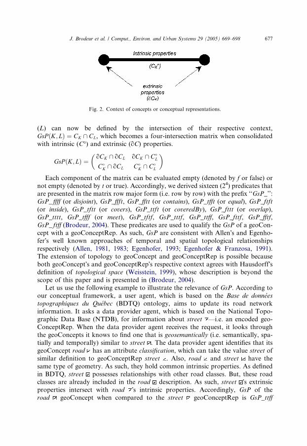
Fig. 2. Context of concepts or conceptual representations.
J. Brodeur et al. / Comput., Environ. and Urban Systems 29 (2005) 669–698 677
(L) can now be defined by the intersection of their respective context,
GsP ðK; LÞ ¼ CK \ CL, which becomes a four-intersection matrix when consolidated
with intrinsic (C�) and extrinsic (oC) properties.
GsP ðK; LÞ ¼oCK \ oCL oCK \ C�
L
C�K \ oCL C�
K \ C�L
� �
Each component of the matrix can be evaluated empty (denoted by f or false) or
not empty (denoted by t or true). Accordingly, we derived sixteen (24) predicates thatare presented in the matrix row major form (i.e. row by row) with the prefix ‘‘GsP_’’:
GsP_ ffff (or disjoint), GsP_ffft, GsP_fftt (or contains), GsP_tfft (or equal), GsP_ftft
(or inside), GsP_tftt (or covers), GsP_ttft (or coveredBy), GsP_fttt (or overlap),
GsP_tttt, GsP_tfff (or meet), GsP_tftf, GsP_tttf, GsP_ttff, GsP_fttf, GsP_fftf,
GsP_ ftff (Brodeur, 2004). These predicates are used to qualify the GsP of a geoCon-
cept with a geoConceptRep. As such, GsP are consistent with Allen�s and Egenho-
fer�s well known approaches of temporal and spatial topological relationships
respectively (Allen, 1981, 1983; Egenhofer, 1993; Egenhofer & Franzosa, 1991).The extension of topology to geoConcept and geoConceptRep is possible because
both geoConcept�s and geoConceptRep�s respective context agrees with Hausdorff�sdefinition of topological space (Weisstein, 1999), whose description is beyond the
scope of this paper and is presented in (Brodeur, 2004).
Let us use the following example to illustrate the relevance of GsP. According to
our conceptual framework, a user agent, which is based on the Base de donnees
topographiques du Quebec (BDTQ) ontology, aims to update its road network
information. It asks a data provider agent, which is based on the National Topo-graphic Data Base (NTDB), for information about street ––i.e. an encoded geo-
ConceptRep. When the data provider agent receives the request, it looks through
the geoConcepts it knows to find one that is geosemantically (i.e. semantically, spa-
tially and temporally) similar to street . The data provider agent identifies that its
geoConcept road has an attribute classification, which can take the value street of
similar definition to geoConceptRep street . Also, road and street have the
same type of geometry. As such, they hold common intrinsic properties. As defined
in BDTQ, street possesses relationships with other road classes. But, these roadclasses are already included in the road description. As such, street �s extrinsic
properties intersect with road �s intrinsic properties. Accordingly, GsP of the
road geoConcept when compared to the street geoConceptRep is GsP_ttff

678 J. Brodeur et al. / Comput., Environ. and Urban Systems 29 (2005) 669–698
(or contains) and, as such, road can be used to answer the request of the user
agent about street .
As used in (Fowler, Perry, Nodine, & Bargmeyer, 1999; Payne, Paolucci, Singh, &
Sycara, 2002; Sycara, Klusch, Widoff, & Lu, 1999), software agents appear well suited
to develop user agents and data provider agents as illustrated in our conceptualframework to experience the GsP notion within a prototype. According to (Nwana,
1996), a software agent is defined as ‘‘a component of a software and/or hardware
which is capable of acting exactingly in order to accomplish tasks on behalf of its
user.’’ In the specific context of the prototype on semantic, spatial, and temporal
interoperability of geospatial data presented in the following section, user and data
provider agents are deployed as software agents, which own a particular ontology
to interoperate with other agents. However, the description of software agent is
beyond the scope of this paper and can be obtained in (Nwana, 1996; Nwana &Wooldridge, 1996).
2.2. Related research work on geospatial data interoperability
In the last few years, a number of authors have also addressed semantic inter-
operability, but differently. Bishr (1997) and Benslimane (2001) both worked on
mediation approaches. Uitermark et al. (1999) and Cruz, Rajendran, Sunna, and
Wiegand (2002) worked on the geospatial data integration issue. Rodriguez (2000)developed a method for measuring the semantic similarity between geographic
concepts.
The Bishr�s (1997) approach, called Semantic Formal Data Structure (SFDS), was
composed of three components: an export schema, a federated schema, and a proxy
context mediator. The export schema serves to publish local database concepts to
users. The federated schema collected domain specific concepts such as for transpor-
tation, soils, etc. Finally, the proxy context mediator consisted of a common onto-
logy that mapped export schema concepts to federated schema concepts in orderto enable the exchange of geospatial information from one system to another.
The Benslimane�s (2001) approach, called the Isis solution, was developed in two
layers: the data and the mediation layer. The data layer referred to heterogeneous
databases with their respective local schemata whereas the mediation layer was de-
scribed in terms of a universe of discourse, a global ontology, a context of reference,
and database specific co-operation contexts. Co-operation contexts were made of co-
operation classes, which served to map concepts from heterogeneous databases.
They serve in a semantic translation process that takes place in the exchange ofgeospatial information.
In Uitermark et al. (1999), domain and application ontologies were used to de-
scribe concepts pertaining to a given discipline such as topographic mapping and
concepts that were stored in individual geospatial databases, respectively. In this ap-
proach, a static semantic mapping was developed between concepts of application
ontologies and concepts of domain ontology in Prolog clauses, which allowed the
integration of geospatial data from heterogeneous databases when queried based
on the domain ontology.

J. Brodeur et al. / Comput., Environ. and Urban Systems 29 (2005) 669–698 679
Similarly, Cruz et al. (2002) worked on a system to overcome semantic interoper-
ability problems when integrating geospatial data from heterogeneous databases. In
their approach, they, proposed the development of a common knowledge––i.e. the
ontology, which was used to interact with local heterogeneous geospatial databases.
Each local database was associated with a static agreement document encoded inXML that mapped its local concepts to ontology�s concepts. When the system re-
ceived a query, the query was rewritten based on the ontology and the local agree-
ment documents in a series of sub-queries that were executed on each local
database. This approach resembles a loosely coupled federated database system
(Sheth, 1999).
Rodriguez (2000) studied the similarity of geographic concepts. She proposed the
Matching Distance (MD) model, based on the ratio model (Tversky, 1977), to mea-
sure a conceptual distance between two geographic concepts to quantify the similar-ity between two geographic concepts. This conceptual distance consisted in a
weighted sum of the semantic proximity of parts, functions, and attributes of two
geographic concepts, where the semantic proximity of these three facets corre-
sponded to the ratio of common elements to the sum of their common and distin-
guishing elements.
The GsP approach differs from the above approaches as it proposes a dynamic
computation of the semantic mapping between two geospatial abstractions (i.e. be-
tween a geoConcept and a geoConceptRep) instead of developing static mappingfiles between concepts of different ontologies. Also, as human beings seem to reason
in more of a qualitative manner, the GsP approach expresses the semantic similarity
between a geoConcept and a geoConceptRep qualitatively, using a set of mutually
exclusive predicates to describe their commonness and difference as opposed to a
quantitative measurement.
3. The GsP prototype
To evaluate the GsP notion, we built a software prototype, called GsP Prototype,
which agrees to our interoperability conceptual framework illustrated in Fig. 1. With
the GsP Prototype, software agents are instantiated and can interoperate with each
other. This section presents successively a high level architecture of the prototype,
the way the prototype operates, and the experimentations conducted so far.
3.1. Architecture
The architecture of GsP Prototype illustrated in Fig. 3 depicts a communication
process, which takes place between two software agents (Agents A and B) interacting
through a communication channel. It details more specifically one agent�s internal
structure and operations as well as the manner in which agents exchange informa-
tion. However, this architecture is not limited to only two agents but can be
expanded to multiple agents interacting in pairs.

Fig. 3. Architecture of the GsP Prototype (from Brodeur and Bedard, 2002).
680 J. Brodeur et al. / Comput., Environ. and Urban Systems 29 (2005) 669–698
In this architecture, all agents have an identical internal structure and operate in
the same manner. They communicate using messages composed of geoConceptReps
encoded in XML streams. When an agent receives a message, it captures the inner
XML geoConceptReps of the message and places them in a transitory internal data
structure containing geoConceptReps. Each geoConceptRep stored in this datastructure can be compared to a human perceptual state.
The geoConceptReps are then passed to a Proxy. The Proxy is a server responsi-
ble for finding geoConcepts that match the geoConceptReps in order to assign them
a meaning. This is the recognition process. The Proxy has to mediate between two
geoConcept storages: geoConMem and geoRep.
GeoConMem is a cache memory limited in size, which stores for a short period the
most recent geoConcepts (the geoConcept structure is detailed further in this section)
used by the agent. It may be compared to the short-term memory of a human being.GeoRep consists of a geospatial data repository that holds the description of all
geoConcepts that the agent knows; it is a direct access storage. In this case, the geo-
Rep storage is implemented using Perceptory and consists of a graph representation
of geoConcepts in a UML class diagram along with a dictionary which manages the
description of semantic, spatial, and temporal properties of geoConcepts. GeoRep
may be compared to the long-term memory of a human being.
When processing, the Proxy examines one by one all the geoConceptReps that the
agent received in a message. For each geoConceptRep of the geoConceptReps datastructure, the Proxy looks first in geoConMem to visit the geoConcepts it stores until
a geoConcept that has a GsP of ‘‘GsP_tfft’’ (or equal) with a first geoConceptRep is
located. It is the geoConcept that is responsible to evaluate its GsP with the geoCon-
ceptRep. As such, it compares all its intrinsic (i.e. identification, attributes, attribute
values, geometries, temporalities, and domain) and extrinsic (i.e. relationships and
behaviours) properties to the geoConceptRep�s intrinsic and extrinsic properties as
in the four-intersection matrix presented in the previous section. However, if no geo-
Concept shows a GsP of ‘‘GsP_tfft’’ (or equal) with the geoConceptRep, then theProxy continues to search in geoRep to find the most similar geoConcept to the geo-
ConceptRep, which consists in the geoConcept that has the highest GsP with the
geoConceptRep. To this end, the Proxy visits geoRep�s geoConcepts to compute

J. Brodeur et al. / Comput., Environ. and Urban Systems 29 (2005) 669–698 681
their respective GsP with the geoConceptRep. As such, it uses a graph traversal algo-
rithm and begins with the geoConcept of the geoConMem cache memory that has the
highest GsP with the geoConceptRep. GeoRep provides geoConcepts to the Proxy
using a geoConcept data structure. When the Proxy gets a geoConcept from geoRep,
it evaluates its GsP with the geoConceptRep and stores it. This process continuesuntil a geoConcept that has a GsP of ‘‘GsP_tfft’’ (or equal) with the geoConceptRep
is found or all concepts are visited. When the process is completed, geoConcepts hav-
ing a GsP different from ‘‘GsP_ffff’’ (or disjoint) with the geoConceptRep are then
sorted from the highest to the lowest GsP. The geoConcept with the highest GsP con-
stitutes the most similar geoConcept to the geoConceptRep, which is then used to
assign a meaning to the geoConceptRep.
It might happen that no geoConcept is found similar to the geoConceptRep and,
accordingly, no meaning can be assigned to the geoConceptRep. Therefore, theagent will not be able to answer to the other agent on this geoConceptRep. The
resulting set of geoConcepts matching the geoConceptReps of the message are then
used by the agent to reply to the other agent. As such, the geoConcepts generate geo-
ConceptReps that are then encoded in an XML stream and sent through the com-
munication channel to the other agent.
Similarly to concepts that compose human cognitive models, geoConcepts ob-
tained from either geoConMem or geoRep consist here of non-visible data elements
(or private as in Java or C++), which are obviously inaccessible to other agents.These data elements are encapsulated by three functions: recognize, generate, and
gspRelate (Fig. 4). The recognition and generate functions serve as the main geo-
Concept interfaces, which are supported by gspRelate that evaluates the GsP.
Fig. 5 draws a more detailed description of the geoConcept object structure in a
UML class diagram. In this diagram, geoConcepts conform to the class GEOCON-
CEPT, which inherits its data structure from the class GEOABSTRACTION. GEO-
ABSTRACTION aims at defining the properties used to identify and describe a
geospatial phenomenon. These properties are divided into two types: intrinsic andextrinsic.
Fig. 4. Object structure of a concept (from Brodeur & Bedard, 2002).

Fig. 5. UML class diagram of GEOABSTRACTION, GEOCONCEPT, and GEOCONCEPTREP.
682 J. Brodeur et al. / Comput., Environ. and Urban Systems 29 (2005) 669–698
On the one hand, the class INTRINSICPROPS accounts for intrinsic propertiesand captures the identification, descriptiveAtts (i.e. descriptive attributes), geometries,
temporalities, and the domainComponents (i.e. various component of the domain) of
a GEOABSTRACTION. Essentially, the identification refers to the name and the
definition given to the GEOABSTRACTION. The descriptiveAtts report on the
inherent characteristics of a phenomenon. A name, a definition, and a domain of val-
ues distinguish each descriptive attribute from another. Geometries refer to the var-
ious types of geometry such as simple geometry (e.g. point, line, or surface),
geometric aggregate, complex geometry, and alternate geometry (Bedard, 1999) thatare used to depict the phenomenon spatially along with its inherent semantics (e.g.
building basement footprint). Similarly to geometries, temporalities refer to the var-
ious types of temporality such as instant, period, temporal aggregate, and alternate
temporality (Bedard, 1999) that are used to depict the phenomenon temporally along
with its inherent semantics (e.g. date when the building construction is completed).
The domain consists of the numerous combinations of attribute values, geometry,
and temporality that the GEOABSTRACTION can take where each combination
refers to one domainComponent.On the other hand, the class EXTRINSICPROPS provides the details of the
extrinsic properties. Extrinsic properties are described in terms of behaviours and
memberships in relationships (relationMembership). A behaviour refers to an opera-
tion that a phenomenon can accomplish. A name, a definition, a list of parameters,
and a return type differentiate each behaviour of a phenomenon. A membership in a
relationship expresses the participation of the phenomenon in a relationship with an-
other phenomenon. It identifies the relationship (name of the relationship and the list
J. Brodeur et al. / Comput., Environ. and Urban Systems 29 (2005) 669–698 683
of members), the role played by the GEOABSTRACTION and its minimum and
maximum cardinalities.
The class GEOCONCEPT has the three functions mentioned above (recognize,
generate, and gspRelate). The function recognize takes a geoConceptRep as an input.
It identifies geoConcepts that are similar to one geoConceptRep prioritized by theirGsP. The function gspRelate assists the function recognize by computing the GsP of
the geoConcept with the geoConceptRep. It evaluates to what extent the geoConcept
matches the geoConceptRep. The function gspRelate assists the function recognize
by computing the GsP of the geoConcept with the geoConceptRep. Finally, the gen-
erate function produces a geoConceptRep of this geoConcept, which holds in a spe-
cific context. Again, the gspRelate function assists the generate function to ensure
that the generated geoConceptRep is similar to the geoConcept.
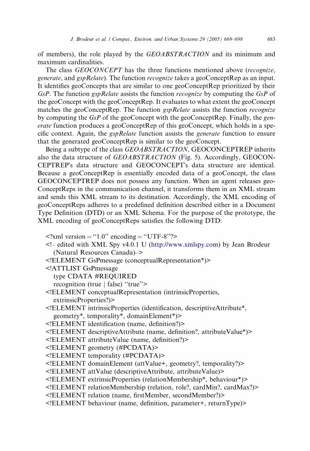
Being a subtype of the class GEOABSTRACTION, GEOCONCEPTREP inheritsalso the data structure of GEOABSTRACTION (Fig. 5). Accordingly, GEOCON-
CEPTREP�s data structure and GEOCONCEPT�s data structure are identical.
Because a geoConceptRep is essentially encoded data of a geoConcept, the class
GEOCONCEPTREP does not possess any function. When an agent releases geo-
ConceptReps in the communication channel, it transforms them in an XML stream
and sends this XML stream to its destination. Accordingly, the XML encoding of
geoConceptReps adheres to a predefined definition described either in a Document
Type Definition (DTD) or an XML Schema. For the purpose of the prototype, theXML encoding of geoConceptReps satisfies the following DTD:
<?xml version¼ ‘‘1.0’’ encoding¼ ‘‘UTF-8’’?>
<!– edited with XML Spy v4.0.1 U (http://www.xmlspy.com) by Jean Brodeur
(Natural Resources Canada)–>
<!ELEMENT GsPmessage (conceptualRepresentation*)>
<!ATTLIST GsPmessage
type CDATA #REQUIREDrecognition (true j false) ‘‘true’’>
<!ELEMENT conceptualRepresentation (intrinsicProperties,
extrinsicProperties?)>
<!ELEMENT intrinsicProperties (identification, descriptiveAttribute*,
geometry*, temporality*, domainElement*)>
<!ELEMENT identification (name, definition?)>
<!ELEMENT descriptiveAttribute (name, definition?, attributeValue*)>
<!ELEMENT attributeValue (name, definition?)><!ELEMENT geometry (#PCDATA)>
<!ELEMENT temporality (#PCDATA)>
<!ELEMENT domainElement (attValue+, geometry?, temporality?)>
<!ELEMENT attValue (descriptiveAttribute, attributeValue)>
<!ELEMENT extrinsicProperties (relationMembership*, behaviour*)>
<!ELEMENT relationMembership (relation, role?, cardMin?, cardMax?)>
<!ELEMENT relation (name, firstMember, secondMember?)>
<!ELEMENT behaviour (name, definition, parameter+, returnType)>

684 J. Brodeur et al. / Comput., Environ. and Urban Systems 29 (2005) 669–698
<!ELEMENT parameter (conceptualRepresentationName, defaultValue?)>
<!ELEMENT name (#PCDATA)>
<!ELEMENT definition (#PCDATA)>
<!ELEMENT role (#PCDATA)>
<!ELEMENT cardMin (#PCDATA)><!ELEMENT cardMax (#PCDATA)>
<!ELEMENT firstMember (#PCDATA)>
<!ELEMENT secondMember (#PCDATA)>
<!ELEMENT conceptualRepresentationName (#PCDATA)>
<!ELEMENT defaultValue (#PCDATA)>
<!ELEMENT returnType (#PCDATA)>
3.2. Implementation
Based on the above architecture, GsP Prototype was implemented with JavaTM
and XML technologies in combination with Perceptory-based geospatial reposito-
ries. The reasons supporting this choice of technologies are:
1. XML is by far a widely recognized technology for the communication of
information;2. Availability of Java libraries to process XML documents (namely the Java API
for XML Processing (JAXP)) (Sun Microsystems Inc., 2002) that includes the
Xalan (The Appache Software Foundation, 2002) and the Xerces (The Appache
Software Foundation, 2002) libraries for parsing and manipulating XML
documents;
3. Portability of the development on the Web; and
4. Perceptory is a technology very well suited to develop geospatial repositories
agreeing to ISO19103 Geographic information––conceptual schema language
(ISO/TC 211, 2001b) and ISO19110 Geographic information––methodology for
feature cataloguing (ISO/TC 211, 2001a), which can then serve as agent�sontologies.
This section presents in detail the implementation of the prototype and the way it
operates.
The GsP Prototype uses interfaces of two kinds: software agent interfaces and an
Agent Manager interface. A software agent appears as a window (Fig. 6). The win-dow�s title bar identifies the agent�s name along with its ontology source name (e.g.
agent1 (NTDB_RN)). The remaining part of the window is divided into two sec-
tions: the Console and the Communication Monitor.
The Console section consists of three components. The first component is a drop-
down menu, which presents the list of geoConcepts that compose the agent�s ontol-ogy. Each geoConcept is identified by a unique name. The next item is the Send
Query button. When clicked, this button initiates a query about the geoConcept se-
lected from the drop-down menu towards an external agent. The external agent is

Fig. 6. The agent window.
J. Brodeur et al. / Comput., Environ. and Urban Systems 29 (2005) 669–698 685
identified by filling its name in the External Agent field of the Communication
Monitor section. The last Console�s component is a field in which the agent displaysmessages.
The Communication Monitor section shows the different steps of the communica-
tion process that are accomplished. When an agent receives a message from an exter-
nal agent, the name of the external agent appears in the External Agent field.
Following this, the agent extracts the geoConceptReps from the message and dis-
plays the name of the geoConceptRep being processed in the Processing geoConcept-
Rep (R00/R00 00) field one by one. Then, the agent initiates the recognition process of the
geoConceptRep and, as such, visits the geoConcepts of the ontology until one isfound similar to the geoConceptRep. Once a geoConcept is identified, its name is
displayed in the geoConcept (R 0/R000) field. When a reply is expected by the external
agent (e.g. answer to a query), the corresponding geoConcept generates a geoCon-
ceptRep of itself and the name of the transmitted geoConceptRep is displayed in
the Transmitting geoConceptRep (R00/R0000) field.
The Agent Manager interface (Fig. 7) is used to instantiate software agents and
displays one agent�s state upon user request. The instantiation of an agent requires
two elements: its identification and the name of an ontology source. The agent�s iden-tification is a unique identifier. The ontology source name consists of the source
Fig. 7. The Agent Manager interface.
686 J. Brodeur et al. / Comput., Environ. and Urban Systems 29 (2005) 669–698
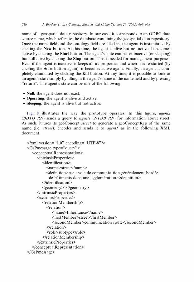
name of a geospatial data repository. In our case, it corresponds to an ODBC data
source name, which refers to the database containing the geospatial data repository.
Once the name field and the ontology field are filled in, the agent is instantiated by
clicking the New button. At this time, the agent is alive but not active. It becomes
active by clicking the Start button. The agent�s state can be set inactive (or sleeping)but still alive by clicking the Stop button. This is needed for management purposes.
Even if the agent is inactive, it keeps all its properties and when it is re-started (by
clicking the Start button again), it becomes active again. Finally, an agent is com-
pletely eliminated by clicking the Kill button. At any time, it is possible to look at
an agent�s state simply by filling in the agent�s name in the name field and by pressing
‘‘return’’. The agent�s state can be one of the following:
• Null: the agent does not exist;• Operating: the agent is alive and active;
• Sleeping: the agent is alive but not active.
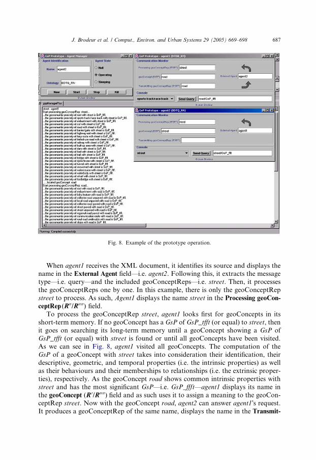
Fig. 8 illustrates the way the prototype operates. In this figure, agent2
(BDTQ_RN) sends a query to agent1 (NTDB_RN) for information about street.
As such, it uses its geoConcept street to generate a geoConceptRep of the same
name (i.e. street), encodes and sends it to agent1 as in the following XML
document.
<?xml version=‘‘1.0’’ encoding=‘‘UTF-8’’?>
<GsPmessage type=‘‘query’’>
<conceptualRepresentation>
<intrinsicProperties>
<identification>
<name>street</name>
<definition>rue : voie de communication generalement bordeede batiments dans une agglomeration.</definition>
</identification>
<geometry>1</geometry>
</intrinsicProperties>
<extrinsicProperties>
<relationMembership>
<relation>
<name>Inheritance</name><firstMember>street</firstMember>
<secondMember>communication route</secondMember>
</relation>
<role>subtype</role>
</relationMembership>
</extrinsicProperties>
</conceptualRepresentation>
</GsPmessage>
J. Brodeur et al. / Comput., Environ. and Urban Systems 29 (2005) 669–698 687
When agent1 receives the XML document, it identifies its source and displays thename in the External Agent field––i.e. agent2. Following this, it extracts the message
type––i.e. query––and the included geoConceptReps––i.e. street. Then, it processes
the geoConceptReps one by one. In this example, there is only the geoConceptRep
street to process. As such, Agent1 displays the name street in the Processing geoCon-
ceptRep (R00/R0000) field.
To process the geoConceptRep street, agent1 looks first for geoConcepts in its
short-term memory. If no geoConcept has a GsP of GsP_tfft (or equal) to street, then
it goes on searching its long-term memory until a geoConcept showing a GsP ofGsP_tfft (or equal) with street is found or until all geoConcepts have been visited.
As we can see in Fig. 8, agent1 visited all geoConcepts. The computation of the
GsP of a geoConcept with street takes into consideration their identification, their
descriptive, geometric, and temporal properties (i.e. the intrinsic properties) as well
as their behaviours and their memberships to relationships (i.e. the extrinsic proper-
ties), respectively. As the geoConcept road shows common intrinsic properties with
street and has the most significant GsP––i.e. GsP_ffft––agent1 displays its name in
the geoConcept (R 0/R00 00) field and as such uses it to assign a meaning to the geoCon-ceptRep street. Now with the geoConcept road, agent2 can answer agent1�s request.It produces a geoConceptRep of the same name, displays the name in the Transmit-
Fig. 8. Example of the prototype operation.
688 J. Brodeur et al. / Comput., Environ. and Urban Systems 29 (2005) 669–698
ting geoConceptRep (R00/R0000) field (e.g. road), encodes the geoConceptRep, and sends
it to agent1 using an XML document similar to the one presented previously where
the attribute type of the gspMessage element is set to ‘‘answer’’.
In turn, when agent2 receives the XML document, it initiates a similar process
as agent1 did. It identifies the message originator and displays its name in theExternal Agent field––i.e. agent1––extracts the message type––i.e. answer––and
the geoConceptRep––i.e. road ––and processes it. Then, agent2 displays the name
road in the field Processing geoConceptRep (R00/R00 00) and computes that its geo-
Concept street is similar (e.g. GsP_ffft) to the geoConceptRep road. As such,
agent2 displays the name street in the geoConcept (R 0/R000) field. Therefore, agent2
acknowledges that road answers its initial query and thus interoperability happens.
Because the message is an answer, no further action is required and the process
stops at this point.
3.3. Experimentation
Using the above software agent-based prototype, we conducted experimentations
on road and hydrographic networks to assess the strength of our approach. These
two themes have been chosen because they are both candidates of the essential con-
tent and the desirable content, respectively, of the Canadian GeoBase (2001), which
is currently being developed. Briefly, GeoBase consists of ‘‘the fundamental geo-graphic information that describes Canadian landmass above and below water’’
(CCOG, 2001) that is established in co-operation with Canadian federal, provincial,
and territorial mapping agencies. The experimentation aimed at assessing computer
feasibility and strength of the GsP approach a priori. Tests were limited to the inter-
action of software agents using on the one hand identical ontologies and on the other
hand different ontologies.
As such, we built UML-based geospatial data repositories on road and hydro-
graphic networks with Perceptory using the following topographic data productspecifications:
(a) National Topographic Data Base––standards and specifications of Canada
(Natural Resources Canada, 1996) (NTDB);
(b) User’s Guide to Digital and Hardcopy property and Basemap Products of Prince
Edward Island (P.E.I. Geomatics Information Centre, n.d.) (PEIBP);
(c) Quebec Topographic Data Base 1:20000––production standards (Quebec,
2000) (QTDB);(d) Ontario Digital Topographic Database––1:10000, 1:20000––a guide for user
(OBM, 1996) (ODTDB);
(e) Digital Baseline Mapping at 1:20000 of the province of British Columbia (BC
Ministry of Environment Lands and Parks (Geographic Data BC, 1992)
(BCDBM).
For example, Figs. 9 and 10 show UML class diagrams corresponding to both
themes of the NTDB data product specifications.
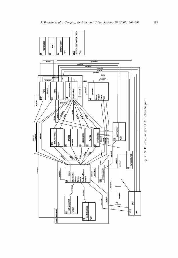
Fig.9.NTDBroadnetwork
UMLclass
diagram.
J. Brodeur et al. / Comput., Environ. and Urban Systems 29 (2005) 669–698 689
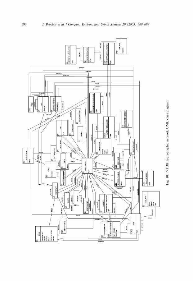
Fig.10.NTDBhydrographic
network
UMLclass
diagram.
690 J. Brodeur et al. / Comput., Environ. and Urban Systems 29 (2005) 669–698

J. Brodeur et al. / Comput., Environ. and Urban Systems 29 (2005) 669–698 691
Each object class and relationship is documented in a data dictionary, which pro-
vides its semantics and their inherent properties as shown in Fig. 11 for the class road
of the NTDB road network (Fig. 9).
Software agents were instantiated using the above geospatial data repositories,
which served as application ontologies. We used ten different software agents, onefor each ontologies, and 46 road network related geoConcepts distributed among
the five different road network ontologies and also 44 hydrographic network related
geoConcepts distributed among the five different hydrographic network ontologies.
We placed road network agents in interaction between themselves using the road net-
work related geoConcepts, and did the same thing the hydrographic network agents.
The results presented hereafter show the success rate where a data provider agent an-
swered adequately to a query from a user agent. The data provider agent either an-
swered it had not understood the query with its own ontology or used a similargeoConcept, which was recognized as such by the user agent, to answer the query.
In the case where interacting software agents were of the same ontology, we observed
that agents used in all cases the same geoConcept to generate and recognize the geo-
ConceptRep of the message, which results in a success rate of 100% for both road
and hydrographic networks (Figs. 12 and 13). For example, the message receives
by an NTDB road network-based agent including a geoConceptRep generated from
the geoConcept Highway exit of another NTDB road network-based agent was al-
ways recognized by the geoConcept Highway exit with a GsP of GsP_tfft (or equal)with the geoConceptRep.
When software agents of different ontologies but related to the same network
(road or hydrographic) were interacting, a geoConcept of the destination agent suc-
ceeds in recognizing the geoConceptRep generated by the source agent when com-
mon intrinsic and extrinsic properties have been identified. We observed that
software agents succeeded in recognizing messages received from another software
agent of a different ontology in a success rate ranging from 30% to 100% depending
on ontologies with a mean of 59% for the road network and 61% for the hydro-graphic network (Figs. 12 and 13). The difference between these results and 100%
is explained because we used an artificial root geoConcept to link the sub-networks
composing an ontology in order to use a graph traversal algorithm to navigate from
one geoConcept to another within the ontology. This artificial root geoConcept has
caused undesirable situations for instance when a geoConcept and a geoConceptRep
had both a relationship with this root geoConcept, they showed a false geosemantic
proximity. Table 1 illustrates a few examples of software agent�s geoConcepts that
automatically recognize geoConceptsReps encoded by another software agent whereboth agents were using different ontologies.
In all these examples, even if the geosemantic proximity between the geoConcept
and the geoConceptRep seems obvious in certain cases (e.g. trail or coastline) be-
cause they appear to be identical abstractions, they are essentially different but sim-
ilar because of all their inherent properties. It is because of their similarity that the
geoConcept can be used to assign a meaning to the geoConceptRep.
However, it is still possible that an agent�s geoConcept may not recognize a
geoConceptRep encoded and transmitted by another agent. The agent�s ability to

Fig. 11. Extract of the class Road of the data dictionary of the NTDB road network (made with
Perceptory).
Fig. 12. Observed success rates––road network.
692 J. Brodeur et al. / Comput., Environ. and Urban Systems 29 (2005) 669–698
recognize a geoConceptRep resides in the richness of its ontology in terms of the geo-
Concepts it knows and the relationships between geoConcepts.

Fig. 13. Observed success rates––hydrographic network.
J. Brodeur et al. / Comput., Environ. and Urban Systems 29 (2005) 669–698 693
These results demonstrate that interoperability is possible between software
agents of different ontologies although their respective data product specifications
have not been developed explicitly for that purpose. To increase the level of interop-
erability of geospatial data, organizations involved in geospatial data acquisition,
management, and dissemination should consider the development with meaningful
geoConcepts in terms of content and relationships between each other, regardlessthe manner they are implemented in geospatial databases. The integration of soft-
ware agents of domain and global ontologies in the prototype would also be an
important improvement for geospatial data interoperability. Finally, the extraction
of semantic information from definitions of geoConcepts, attributes, and attribute
values typically stored in natural language in geospatial data repositories would fur-
ther enhance the evaluation of GsP.
4. Conclusion
In this paper, we reviewed our conceptual framework for geospatial data interop-
erability, which has been derived from human communication and cognition theo-
ries. In this framework, user and data provider agents maintain in memory a set
of geoConcepts, which constitute their respective ontologies. Agents communicate
geoConcepts to others by generating and transmitting representations of the geo-
Concepts––i.e. geoConceptReps. When receiving a message, an agent goes throughits geoConcepts to find those that recognize the message�s geoConceptReps and then
to give them a meaning. The notion of geosemantic proximity is here in support of
these geoConcept�s capabilities––i.e. to generate and recognize geoConceptReps.
By the geosemantic proximity, a geoConcept assesses its semantic, spatial, and
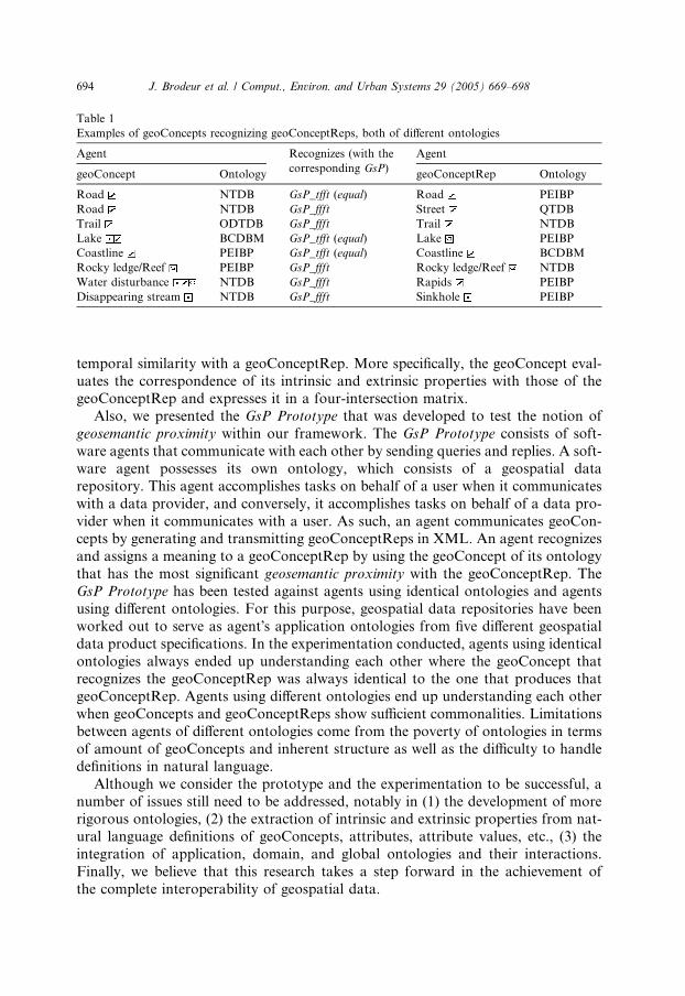
Table 1
Examples of geoConcepts recognizing geoConceptReps, both of different ontologies
Agent Recognizes (with the
corresponding GsP)
Agent
geoConcept Ontology geoConceptRep Ontology
Road NTDB GsP_tfft (equal) Road PEIBP
Road NTDB GsP_ffft Street QTDB
Trail ODTDB GsP_ffft Trail NTDB
Lake BCDBM GsP_tfft (equal) Lake PEIBP
Coastline PEIBP GsP_tfft (equal) Coastline BCDBM
Rocky ledge/Reef PEIBP GsP_ffft Rocky ledge/Reef NTDB
Water disturbance NTDB GsP_ffft Rapids PEIBP
Disappearing stream NTDB GsP_ffft Sinkhole PEIBP
694 J. Brodeur et al. / Comput., Environ. and Urban Systems 29 (2005) 669–698
temporal similarity with a geoConceptRep. More specifically, the geoConcept eval-
uates the correspondence of its intrinsic and extrinsic properties with those of thegeoConceptRep and expresses it in a four-intersection matrix.
Also, we presented the GsP Prototype that was developed to test the notion of
geosemantic proximity within our framework. The GsP Prototype consists of soft-
ware agents that communicate with each other by sending queries and replies. A soft-
ware agent possesses its own ontology, which consists of a geospatial data
repository. This agent accomplishes tasks on behalf of a user when it communicates
with a data provider, and conversely, it accomplishes tasks on behalf of a data pro-
vider when it communicates with a user. As such, an agent communicates geoCon-cepts by generating and transmitting geoConceptReps in XML. An agent recognizes
and assigns a meaning to a geoConceptRep by using the geoConcept of its ontology
that has the most significant geosemantic proximity with the geoConceptRep. The
GsP Prototype has been tested against agents using identical ontologies and agents
using different ontologies. For this purpose, geospatial data repositories have been
worked out to serve as agent�s application ontologies from five different geospatial
data product specifications. In the experimentation conducted, agents using identical
ontologies always ended up understanding each other where the geoConcept thatrecognizes the geoConceptRep was always identical to the one that produces that
geoConceptRep. Agents using different ontologies end up understanding each other
when geoConcepts and geoConceptReps show sufficient commonalities. Limitations
between agents of different ontologies come from the poverty of ontologies in terms
of amount of geoConcepts and inherent structure as well as the difficulty to handle
definitions in natural language.
Although we consider the prototype and the experimentation to be successful, a
number of issues still need to be addressed, notably in (1) the development of morerigorous ontologies, (2) the extraction of intrinsic and extrinsic properties from nat-
ural language definitions of geoConcepts, attributes, attribute values, etc., (3) the
integration of application, domain, and global ontologies and their interactions.
Finally, we believe that this research takes a step forward in the achievement of
the complete interoperability of geospatial data.

J. Brodeur et al. / Comput., Environ. and Urban Systems 29 (2005) 669–698 695
Acknowledgements
The authors wish to acknowledge the contribution of Natural Resources
Canada––Centre for Topographic Information in supporting the first author for this
research and of the GEOIDE Network of Centres of Excellence in geomatics, projectDEC#2 (Designing the Technological Foundations of Spatial Decision-making with
the World Wide Web).
References
Allen, J. F. (1981). An interval-based representation of temporal knowledge. In Proceedings of
international joint conference on artificial intelligence (pp. 221–226).
Allen, J. F. (1983). Maintaining knowledge about temporal intervals. Communication of the ACM, 26,
832–843.
Barsalou, L. W. (1999). Perceptual symbol systems. Behavioral and Brain Sciences, 22, 577–609.
BC Ministry of Environment Lands and Parks (Geographic Data BC) (1992). Digital baseline mapping at
1:20,000 (Release 2.0). Victoria, Province of British Columbia: BC Ministry of Environment, Lands
and Parks.
Bedard, Y. (1999). Visual modelling of spatial database towards spatial PVL and UML. Geomatica, 53,
169–186.
Bedard, Y., Proulx, M.-J. (2002). Perceptory web site [web page document]. Available from: http://
sirs.scg.ulaval.ca/Perceptory.
Benslimane, D. (2001). Interoperabilite de SIG: la solution Isis. Revue internationale de geomatique, 11,
7–42.
Bishr, Y. (1997). Semantics aspects of interoperable GIS, Ph.D. Dissertation. ITC Publication.
Bittner, T., & Edwards, G. (2001). Toward an ontology for geomatics. Geomatica, 55, 475–490.
Brodeur, J. (2004). Interoperabilite des donnees geospatiales: Elaboration du concept de proximite
geosemantique, These de doctorat, Universite Laval.
Brodeur, J., & Bedard, Y. (2001). Geosemantic proximity, a component of spatial data interoperability. In
Proceedings of international workshop on semantics in enterprise integration (OOPSLA 2001) (6 p).
Brodeur, J., & Bedard, Y. (2002). Extending geospatial repositories with geosemantic proximity
functionalities to facilitate the interoperability of geospatial data. In Proceedings of ISPRS, SDH2002
and CIG joint international symposium on geospatial theory, processing and application (6 p).
Brodeur, J., Bedard, Y., Edwards, G., & Moulin, B. (2003). Revisiting the concept of geospatial data
interoperability within the scope of a human communication process. Transactions in GIS, 7, 243–265.
Brodeur, J., Bedard, Y., & Proulx, M. J. (2000). Modelling geospatial application databases using UML-
based repositories aligned with international standards in geomatics. In K. J. Li, K. Makki, N.
Pissinou, & S. Ravada (Eds.), Proceedings of eighth ACM symposium on advances in geographic
information systems (ACMGIS ) (pp. 39–46). ACM Press.
CCOG––Working group on base data quality issue (2001). A new vision for quality base geographic
information in Canada––GeoBase.
Charron, J. (1995). Developpement d�un processus de selection des meilleures sources de donnees
cartographiques pour leur integration a une base de donnees a reference spatiale, Memoire de maıtrise.
Universite Laval.
Cruz, I. F., Rajendran, A., Sunna, W., Wiegand, N. (2002). Handling semantic heterogeneities using
declarative agreements. In Proceedings of ACM-GIS 2002, The 10th ACM international symposium on
advances in geographic information systems (pp. 168–174). McLean, VA.
Egenhofer, M. J. (1993). A model for detailed binary topological relationships. Geomatica, 47, 261–273.
Egenhofer, M. J. (1999). Introduction: theory and concepts. In M. Goodchild, M. Egenhofer, R. Fegeas,
& C. Kottman (Eds.), Interoperating geographic information systems (pp. 1–4). Boston, MA: Kluwer
Academic Publisher.
696 J. Brodeur et al. / Comput., Environ. and Urban Systems 29 (2005) 669–698
Egenhofer, M. J., & Franzosa, R. D. (1991). Point-set topological spatial relations. International Journal of
Geographic Information Science, 5, 161–174.
FGDC (2002). NSDI [web page document]. Available from: http://www.fgdc.gov/nsdi/nsdi.html.
Fonseca, F., & Egenhofer, M. (1999). Ontology-driven geographic information systems. In Proceedings of
7th International Symposium on Advances in Geographic Information Systems (ACMGIS ) (pp. 14–19).
ACM Press.
Fonseca, F. T., Egenhofer, M. J., Davis, C. A., Jr., & Borges, K. A. V. (2000). Ontologies and knowledge
sharing in urban GIS. Computer Environment and Urban Systems, 24, 251–271.
Fowler, J., Perry, B., Nodine, M., & Bargmeyer, B. (1999). Agent-based semantic interoperability in
InfoSleuth. Sigmod Record, 28, 8.
Frank, A. U. (2001). Tiers of ontology and consistency constraints in geographic information systems.
International Journal of Geographic Information Science, 15, 667–678.
GeoBase (2001). National GeoBase Definition.
GeoConnections (2002). Canadian geospatial data infrastructure (CGDI) architecture [electronic
document]. Available from: http://www.geoconnections.org/architecture/index_e.html.
Gruber, T. R. (1993). Toward principles for the design of ontologies used for knowledge sharing.
Technical Report KSL 93–04 (22 p). Palo Alto, California: Knowledge Systems Laboratory.
Guarino, N. (1998). Formal ontology and information systems. In N. Guarino (Ed.), Proceedings of
formal ontology in information systems (FOIS �98) (pp. 3–15). Amsterdam: IOS Press.
Guarino, N., & Welty, C. (2000). A formal ontology of properties. In R. Dieng & O. Corby (Eds.),
Proceedings of knowledge engineering and knowledge management: methods, models and tools (12th
international conference, EKAW2000 ): Vol. 1937. Lecture Notes in Computer Science (pp. 97–112).
Berlin: Springer-Verlag.
Harvey, F. J. (2002). Semantic interoperability and citizen/government interaction. In Proceedings of
spatial data handling 2002: joint international symposium on geospatial theory, processing, and
applications (13 p).
Institute of Electrical and Electronics Engineers (1990). IEEE standard computer dictionary: a compilation
of IEEE standard computer glossaries New York, NY.
ISO/TC 211 (2001a). ISO/DIS 19110 geographic information––feature cataloguing methodology. Geneva,
Switzerland: International Organization for Standardization.
ISO/TC 211 (2001b). ISO/PDTS 19103 geographic information––conceptual schema language. Geneva,
Switzerland: International Organization for Standardization.
ISO/TC 211 (2003a). ISO 19107:2003 geographic information––spatial schema. Geneva, Switzerland:
International Organization for Standardization.
ISO/TC 211 (2003b). ISO 19115:2003 geographic information––metadata. Geneva, Switzerland: Interna-
tional Organization for Standardization.
Jones, M. (1991). Brave new world: a vision of IRDS. Database Programming and Design, 43–49.
Kashyap, V., & Sheth, A. (1996). Semantic and schematic similarities between database objects: a context-
based approach. The VLDB Journal, 5, 276–304.
Kottman, C. (1999). The open GIS consortium and progress toward interoperability in GIS. In M.
Goodchild, M. Egenhofer, R. Fegeas, & C. Kottman (Eds.), Interoperating geographic information
systems (pp. 39–54). Boston, MA: Kluwer Academic Publisher.
Kuhn, W. (2000). Ontologies from texts. In Proceedings of first international conference on geographic
information science (p. 3). Savannah, Georgia.
Kuhn, W. (2003). Semantic reference systems. International Journal of Geographical Information Science,
17, 405–409.
Laurini, R. (1998). Spatial multi-database topological continuity and indexing: a step towards
seamless GIS data interoperability. International Journal of Geographic Information Science, 12,
373–402.
Lehmann, F. (1992). Semantic networks. Computers and Mathematics with Applications, 23, 50.
Marco, D. (2000). Building and managing the meta data repository. Wiley.
McKee, L., & Buehler, K. (Eds.). (1998). The OpenGIS guide (third ed.). Wayland, MA: OpenGIS
Consortium Inc.

J. Brodeur et al. / Comput., Environ. and Urban Systems 29 (2005) 669–698 697
Moriarty, T. (1990). Are you ready for a repository? Database Programming and Design, March 1990,
62–71.
Natural Resources Canada (1996). National topographic data base––standards and specifications (3.1 ed.).
Sherbrooke, Quebec: Centre for Topographic Information––Sherbrooke.
Nwana, H. S. (1996). Software agents: an overview. The Knowledge Engineering Review, 11, 205–244.
Nwana, H. S., & Wooldridge, M. (1996). Software agent technologies. BT Technology Journal, 14, 68–78.
OBM (1996). Ontario digital topographic database––1:10,000, 1:20,000––a guide for user. Toronto,
Ontario: Ministry of Natural Resources.
Open GIS Consortium Inc. (1999). OpenGIS simple features specification for SQL. Wayland, MA:
OpenGIS Consortium Inc.
Open GIS Consortium Inc. (2001). Geography markup language (GML) 2.0. Wayland, MA: Open GIS
Consortium Inc.
Ouksel, A. M., & Sheth, A. (1999). Semantic interoperability in global information systems: a brief
introduction to the research area and the special section. Sigmod Record, 28, 5–12.
P.E.I. Geomatics Information Centre (n.d.). User�s guide to digital and hardcopy property and basemap
products. Charlottetown, P.E.I.: Provincial Treasury––Taxation and Property Records Division.
Payne, T. R., Paolucci, M., Singh, R., & Sycara, K. (2002). Communicating agents in open agent systems.
In Proceedings of first GSFC/JPL workshop on radical agent concepts (WRAC ) (p. 10).
Peuquet, D., Smith, B., & Brogaard, B. (1998). The ontology of fields. In Proceedings of summer assembly
of the university consortium for geographic information science.
Prabandham, M., Selfridge, W. J., & Mann, D. D. (1990). The role of IRDS. Database Programming and
Design, April 1990, 41–48.
Quebec (2000). Base de donnees topographiques du Quebec (BDTQ) a l�echelle de 1/20000––Normes de
production (Version 1.0) [CD document].
Renner, S. A. (2001). A ‘‘Community of Interest’’ approach to data interoperability. In Proceedings of
federal database colloquium 2001 (p. 7). San Diego.
Rodriguez, M. A. (2000). Assessing semantic similarity among entity classes, Ph.D. Thesis. University of
Maine.
Schramm, W. (1971). The nature of communication between humans. In W. Schramm & D. F. Robert
(Eds.), The process and effects of mass communication (pp. 3–53). Champaign-Urbana, IL: University of
Illinois Press.
Sheth, A. (1999). Changing focus on interoperability in information systems: from systems, syntax,
structure to semantics. In M. Goodchild, M. Egenhofer, R. Fegeas, & C. Kottman (Eds.),
Interoperating geographic information systems (pp. 5–29). Boston, MA: Kluwer Academic Publisher.
Sheth, A., & Kashyap, V. (1992). So far (schematically) yet so near (semantically). In D. K. Hsiao, E. J.
Neuhold, & R. Saks-Davis (Eds.), Proceedings of IFIP WG2.6 database semantics conference on
interoperable database systems (DS-5 )/IFIP transaction (A-25) (pp. 283–312). Elsevier Science
Publishers B.V.
Simsion, G. C. (2001). Data modeling essentials––analysis, design, and innovation (2nd ed.). Scottsdale,
Arizona: Coriolis.
Smith, B., & Mark, D. (1999). Ontology with human subjects testing: an empirical investigation of
geographic categories. American Journal of Economics and Sociology, 58, 245–272.
Sondheim, M., Gardels, K., & Buehler, K. (1999). GIS interoperability. In P. A. Longley, M. F.
Goodchild, D. J. Maguire, & D. W. Rhind (Eds.), Geographical information systems: principles,
techniques, applications and management (pp. 347–358). New York: John Wiley and Sons, Inc.
Statistics Canada (1997). Digital boundary file and digital cartographic file 1996 census (reference guide).
Ottawa: Minister of Industry.
Sun Microsystems Inc. (2002). JavaTM API for XML Processing (JAXP) [web page document]. Available
from: http://java.sun.com/xml/jaxp/index.html.
Sycara, K., Klusch, M., Widoff, S., & Lu, J. (1999). Dynamic service matchmaking among agents in open
information environments. Sigmod Record, 28, 47–53.
The Appache Sofware Foundation (2002). Xalan-Java version 2.4.0 [web page document]. Available from:
http://xml.apache.org/xalan-j/.

698 J. Brodeur et al. / Comput., Environ. and Urban Systems 29 (2005) 669–698
Tversky, A. (1977). Features of similarity. Psychological Review, 84, 327–352.
Uitermark, H. T., van Oosterom, P. J. M., Mars, N. J. I., & Molenaar, M. (1999). Ontology-based
geographic data set integration. In M. H. Bohlen, C. S. Jensen, & M. O. Scholl (Eds.), Proceedings of
spatio-temporal database management, international workshop STDBM’99: vol. 1678. Lecture notes in
computer science (pp. 60–78). Berlin, Heidelberg: Springer-Verlag.
VMap (1995). Vector Map (VMap), Level 1. Mil-V-89033 (331 p). Bethesda, MD: US National Imagery
and Mapping Agency.
Weisstein, E. W. (1999). Topological space [web page document]. Available from: http://mathworld.wol-
fram.com/TopologicalSpace.html.
Xhu, Z., & Lee, Y. C. (2002). Semantic heterogeneity of geodata. In Proceedings of ISPRS commission IV
symposium 2002: joint international symposium on geospatial theory, processing, and applications (6 p).