a dual-polarization radar hydrometeor classification
TRANSCRIPT

A Dual-Polarization Radar Hydrometeor Classification Algorithm for WinterPrecipitation
ELIZABETH J. THOMPSON, STEVEN A. RUTLEDGE, AND BRENDA DOLAN
Department of Atmospheric Science, Colorado State University, Fort Collins, Colorado
V. CHANDRASEKAR
Department of Electrical and Computer Engineering, Colorado State University, Fort Collins, Colorado
BOON LENG CHEONG
Advanced Radar Research Center, University of Oklahoma, Norman, Oklahoma
(Manuscript received 20 May 2013, in final form 16 February 2014)
ABSTRACT
The purpose of this study is to demonstrate the use of polarimetric observations in a radar-based winter
hydrometeor classification algorithm. This is accomplished by deriving bulk electromagnetic scattering
properties of stratiform, cold-season rain, freezing rain, sleet, dry aggregated snowflakes, dendritic snow
crystals, and platelike snow crystals at X-, C-, and S-band wavelengths based on microphysical theory and
previous observational studies. These results are then used to define the expected value ranges, or mem-
bership beta functions, of a simple fuzzy-logic hydrometeor classification algorithm. To test the algorithm’s
validity and robustness, polarimetric radar data and algorithm output from four unique winter storms are
investigated alongside surface observations and thermodynamic soundings. This analysis supports that the
algorithm is able to realistically discern regions dominated by wet snow, aggregates, plates, dendrites, and
other small ice crystals based solely on polarimetric data, with guidance from a melting-level detection al-
gorithm but without external temperature information. Temperature is still used to distinguish rain from
freezing rain or sleet below the radar-detected melting level. After appropriate data quality control, little
modification of the algorithm was required to produce physically reasonable results on four different radar
platforms at X, C, and S bands. However, classification seemed more robust at shorter wavelengths because
the specific differential phase is heavily weighted in ice crystal classification decisions. It is suggested that
parts, or all, of this algorithm could be applicable in both operational and research settings.
1. Introduction and background
Reducing uncertainty associated with winter storm
precipitation type, accumulation, and timing is a major
forecasting, safety, and socioeconomic challenge (Ralph
et al. 2005; Kringlebotn Nygaard et al. 2011; Smith et al.
2012). These rapidly evolving mesoscale systems will be
better understood with the national dual-polarization
radar upgrade through use of hydrometeor classification
algorithms (HCAs; Liu and Chandrasekar 2000; Zrni�c
et al. 2001; Park et al. 2009; Chandrasekar et al. 2013).
Cold-season microphysical processes observable by
polarimetric radars and whose origins are generally
agreed upon include dendritic ice crystal growth zones
(DGZs; Kennedy and Rutledge 2011; Andri�c et al. 2013;
Bechini et al. 2013), plate crystal growth (Pruppacher and
Klett 1997; Wolde and Vali 2001; Williams et al. 2011,
2013), ice particle density and shape modulations caused
by riming and crystal aggregation (Vivekanandan et al.
1994), hydrometeor melting (Ryzhkov et al. 1998), and
near-surface refreezing of either rain or freezing rain into
sleet1 (Kumjian et al. 2013).
Detection of these winter phenomena by dual-
polarization HCAs is important. For instance, enhanced
Corresponding author address: Elizabeth J. Thompson, De-
partment of Atmospheric Science, Colorado State University, 1371
Campus Delivery, Fort Collins, CO 80523-1371.
E-mail: [email protected]
1 Sleet and ice pellets refer to the same thing and are used
interchangeably in this study.
VOLUME 31 JOURNAL OF ATMOSPHER I C AND OCEAN IC TECHNOLOGY JULY 2014
DOI: 10.1175/JTECH-D-13-00119.1
� 2014 American Meteorological Society 1457
production and subsequent aggregation of large dendritic
crystals aloft can lead to high precipitation rates, degra-
dation of visibility, and disruptive snowfall accumulations
(Fujiyoshi and Wakahama 1985; Kennedy and Rutledge
2011; Bechini et al. 2013). Relationships between Zh and
snowfall for quantitative precipitation estimation and ice
water content calculations could be improved by first
determining the crystal type (Vivekanandan et al. 1994;
Mitchell 1996; Ryzhkov et al. 1998; Wolfe and Snider
2012). The variable density of ice crystals is a major
source of uncertainty in these techniques. Radar dis-
crimination of plates and dendrites may also provide
insight into the relative saturation of the environment
and its ability to sustain aircraft icing conditions
(Williams et al. 2011, 2013). Finally, radar detection of
sleet (Kumjian et al. 2013) would provide valuable
nowcasting information (Cortinas et al. 2004).
The goal of this paper is to develop and demonstrate
a method for classifying these dominant, bulk winter
hydrometeor types/processes based on the discriminatory
power of polarimetric radar variables at X, C, and S
bands. To this end, relevant information about the dis-
tribution of sizes, orientations, shapes, and diversity of
hydrometeors within a particular radar sample volume
can be garnered from the differential reflectivity (Zdr),
correlation coefficient (rhy), and specific differential
phase (Kdp). Review of variables and their application
to HCAs can be found in Bringi and Chandrasekar
(2001) and Straka et al. (2000). Simply stated,Zdr andKdp
are both positive (negative) for horizontally (vertically)
aligned hydrometeors and zero for spherical particles,
including those that effectively appear spherical to a ra-
dar because of excessive canting or tumbling. For a given
oblate particle, Kdp and Zdr increase with ice or liquid
water content, though only Kdp is inversely proportional
to radar wavelength. The radar reflectivity (Zh) also gives
an indication of hydrometeor size and concentration.
Competing processes such as riming (Fujiyoshi and
Wakahama 1985; Mosimann 1995; Zawadzki et al. 2001)
and aggregation contribute toward uncertainty in dis-
cerning crystal characteristics or their growth environ-
ment using radar. A cloud’s humidity and temperature
may change under the influence of vapor-rich updrafts
(Rauber and Tokay 1991) or during precipitation de-
scent. The crystal growth regime might gradually or
abruptly transition between thick plates, thin plates,
sector plates, and finally to dendrites (Pruppacher and
Klett 1997). Any new crystal habit growth is super-
imposed on previous growth, so the radar only provides
a snapshot of current ice crystal characteristics. Addi-
tionally, several types of crystals may be present within
a single radar gate, some of which may dominate the
returned radar signal.
Nonetheless, routine, nationwide dual-polarization
radar observations of precipitation type should provide
a foundation for improving wintertime forecasts and
mixed-phase microphysical parameterizations in nu-
merical models (Cotton et al. 2011). Rauber et al. (2001)
suggest the key to developing a mixed-phase precipi-
tation forecast is accounting for complex phase change
physics, including the effect of different ice particle
habits falling through the melting layer. For instance,
large aggregates may delay or prolong the melting pro-
cess. If they survive descent through the melting layer,
then these wet, semimelted snowflakes may promote the
production of sleet instead of freezing rain in the presence
of a sufficiently cold and deep surface layer (Th�eriault
et al. 2006). Surface observation or mesonet systems such
as the Automated Surface Observing System (ASOS) or
routine weather reports (METAR), rapidly disseminated
model output, and upper-air soundings cannot indepen-
dently discern different snow crystal types, rain, freezing
rain, or sleet with much confidence for several reasons
(Elmore 2011; Schuur et al. 2012). These observational
methods do not offer the temporal or spatial resolution
available from radar, either.
Hydrometeor classification algorithms combining at-
mospheric soundings with polarimetric radar observa-
tions have been successful for warm-season, convective
precipitation (Liu and Chandrasekar 2000; Zrni�c et al.
2001; Ryzhkov et al. 2005b; Dolan and Rutledge 2009;
Park et al. 2009; Chandrasekar et al. 2013; Dolan et al.
2013) because the freezing level does not vary much
in space or time. This is not the case for winter pre-
cipitation though, which motivates use of a polarimetric
radar-based melting-layer detection algorithm to iden-
tify wet or melting snow and then inform additional
classification steps below and above this radar bright-
band layer (Giangrande et al. 2008; Boodoo et al. 2010).
To date, wintertime polarimetric classification algo-
rithms using melting-layer detection techniques and ex-
ternal temperature information (from either a sounding or
model forecast) have attempted to identify winter hydro-
meteor types with varying levels of success (Kouketsu and
Uyeda 2010; Elmore 2011; Schuur et al. 2012). Elmore
(2011) showed that the radar’s inability to identify the
refreezing of raindrops and that errors in themelting-layer
detection algorithm led to poor overall performance in
diagnosing surfaceweather conditions. Schuur et al. (2012)
produced satisfactory results using an algorithm based on
rapidly updated model output temperature and moisture
fields along with polarimetric radar data. The methodol-
ogy presented by Schuur et al. (2012) is particularly valu-
able at far ranges where the radar resolution is degraded,
and below the lowest elevation angle scan where surface
weather conditions cannot be diagnosed by the radar at all.
1458 JOURNAL OF ATMOSPHER IC AND OCEAN IC TECHNOLOGY VOLUME 31

Polarimetric signatures for plate and dendritic crys-
tals, as well as the recently discovered refreezing sig-
nature (Kumjian et al. 2013), have been documented
and can be long lived but have not yet been im-
plemented in any hydrometeor classification scheme. It
is important to note that these signatures have been
validated with external temperature data in aforemen-
tioned studies, but they do not require temperature in-
formation for real-time detection. Furthermore, no
previous winter HCA has fully exploited the potential
uses of Kdp (especially at shorter radar wavelengths),
which should be extremely useful in discerning ice
crystal habit. Since a melting-layer detection algorithm
can be used, the strong radar signatures demonstrated
by certain winter hydrometeor types might be sufficient
for classification with little to no use of external tem-
perature information (Zrni�c et al. 2001), possibly re-
ducing computational expenses.
To develop such a cold-season HCA that is as au-
tonomous as possible and to assess its performance at
various wavelengths, scattering simulations of polari-
metric radar variables at X, C, and S bands based on the
physical properties of dendrites, plates, dry aggregated
snowflakes, rain, freezing rain, and sleet are outlined in
section 2 and discussed in section 3. Then the algorithm
is developed based on these theoretical results in section 4
and validated with radar, thermodynamic, and surface
data during four winter storms in section 5. Section 6
provides a summary and suggestions for future algo-
rithm use and improvement.
2. Electromagnetic scattering simulationmethodology
a. T-matrix and Mueller-matrix models
T-matrix and Mueller-matrix scattering models
(Waterman 1965; Barber and Yeh 1975) were used to
create HCA membership beta functions (MBFs) for
various winter hydrometeor types. See Vivekanandan
et al. (1991), Liu and Chandrasekar (2000), Zrni�c et al.
(2001), Dolan and Rutledge (2009), and Chandrasekar
et al. (2013) for algorithm definitions and equations.
Permutations of each hydrometeor’s input parameters
shown in Table 1 were used in the T-matrix model to
compute the radar backscattering cross section of dif-
ferent particles. Then the Mueller matrix calculates po-
larimetric radar observations for each homogeneous,
parameterized size distribution. These simulations were
aggregated together to produce a range of expected
values for each precipitation type.
All hydrometeors are modeled as oblate spheroids
without branched or otherwise irregular shapes, which
is sufficient for X-, C-, and S-band weather radar
applications (Bringi and Chandrasekar 2001; Botta et al.
2010; Hogan et al. 2012). While scattering simulations
are sensitive to phase (ice vs liquid), the results were
negligibly sensitive to changes in temperature. Two el-
evation angles, 308 and 18, were simulated to determine
how the radar would perceive higher-altitude ice parti-
cles. Sleet and rain should only exist below the melting
level, so they were simply modeled at 18.Hydrometeor bulk density (rbulk) is defined as the
particle’s mass per unit volume. The axis ratio is as-
sumed to compare the vertical (minor, ‘‘y’’, basal, a-axis
growth face) and horizontal (major, ‘‘x’’, prism, c-axis
face) dimensions of a particle (‘‘y/x’’), where the axis
ratio is unity for spheres. The particle size distribution
(PSD), DMIN, DMAX, diameter interval (DD), number
concentration (N0 or NW), slope (l), and functional
shape (m) are parameterized, from which we calculate
D0 (median diameter of the PSD). To represent the
natural variability of precipitation in turbulent back-
ground flow, all hydrometeors are assumed to have
a Gaussian distribution of canting angles about a mean
(um) of zero (Hendry et al. 1976; Beard and Jameson
1983; Ryzhkov 2001; Spek et al. 2008). Then a certain
standard deviation of the canting angle (s) from zero is
implemented to represent fluttering or tumbling. The
fall behavior of individual particles may vary greatly, but
in the interest of distinguishing bulk hydrometeor types,
we implemented s values that best characterized how
each particle type might fall differently from another.
b. Model parameterizations for varioushydrometeors
Wet ormelting snowwas notmodeled in this study but
its inclusion in the classification algorithm is discussed in
section 4. A ‘‘blanket’’ ice crystal category [based on
Dolan and Rutledge’s (2009) ‘‘ice crystals’’] was also
added to accommodate prevalent but innocuous small
isometric ice crystals found above the melting layer with
low Zh, Zdr, and Kdp. It should be noted that bullet-,
rosette-, and stellar-crystal-shape extensions are too
complex to be modeled with quasi-spherical approxima-
tion models (Botta et al. 2010), and the bulk differences
between these hydrometeors cannot be appreciated by
K- through S-band frequency radars (Vivekanandan et al.
1994). Although graupel can form in winter storms
(Reinking 1975; Takahashi and Fukuta 1988; Takahashi
et al. 1999), a graupel category was not included herein
because we examine primarily stratiform winter case
studies.
1) DENDRITES AND PLATES
Because of their skeletal framework, dendrites are
modeled with low rbulk between 0.3 and 0.5 g cm23
JULY 2014 THOMPSON ET AL . 1459
(Heymsfield 1972; Fukuta and Takahashi 1999). These
branched crystals tend to flutter as they slowly fall,
with their maximum dimension oriented horizontally
(Pruppacher and Klett 1997). This is represented with
s 5 158 (Matrosov et al. 2006; Kennedy and Rutledge
2011). We modeled PSDs observed by Lo and Passarelli
(1982) for pristine dendrites prior to the onset of ag-
gregation. Many studies have confirmed that an expo-
nential PSD is sufficient to describe crystal populations
(Pruppacher and Klett 1997), but the exact PSD of
particular ice crystals is still uncertain. The simulations
presented here serve as a proof of concept for the in-
formation available in the literature. In section 5, we
assess these results with radar observations.
The median and maximum diameter of dendrites can
be longer (up to 1.3 cm; Mitchell 1996; Pruppacher and
Klett 1997; Kennedy and Rutledge 2011) than plates,
which have less favorable geometry for growth and are
associated with lower ice supersaturations (usually un-
saturated with respect to water; Pruppacher and Klett
1997; Foster and Hallett 2008). Plates are assumed to be
solid ice (Pruppacher and Klett 1997) and exhibit ap-
proximately the same canting behavior as dendrites.
However, plates have more sloped PSDs because of
their muted growth, which results in more numerous
small crystals (Bader et al. 1987; Ryan 2000). Small
D ranges and D0 observations of unrimed plates
(Pruppacher and Klett 1997) match those modeled
herein. It should be noted that our scattering model
could only simulate DMAX # 1 cm. PSD parameteriza-
tions were still deemed sufficient becauseD0 was always
well contained within DMAX (see Table 1) and agreed
with crystal D0 observations.
The vertical thickness of plates and dendrites is the
same but their horizontal dimensions differ based
on growth conditions, and therefore dendrites are
slightly more oblate (Auer and Veal 1970). We quali-
tatively followed the data from Auer and Veal (1970),
but our model became computationally unstable for
the very small axis ratios they suggest (y/x , 0.135;
Matrosov et al. 2012). Therefore, plates were modeled
with axis ratios of 0.2–0.5 (Williams et al. 2011, 2013),
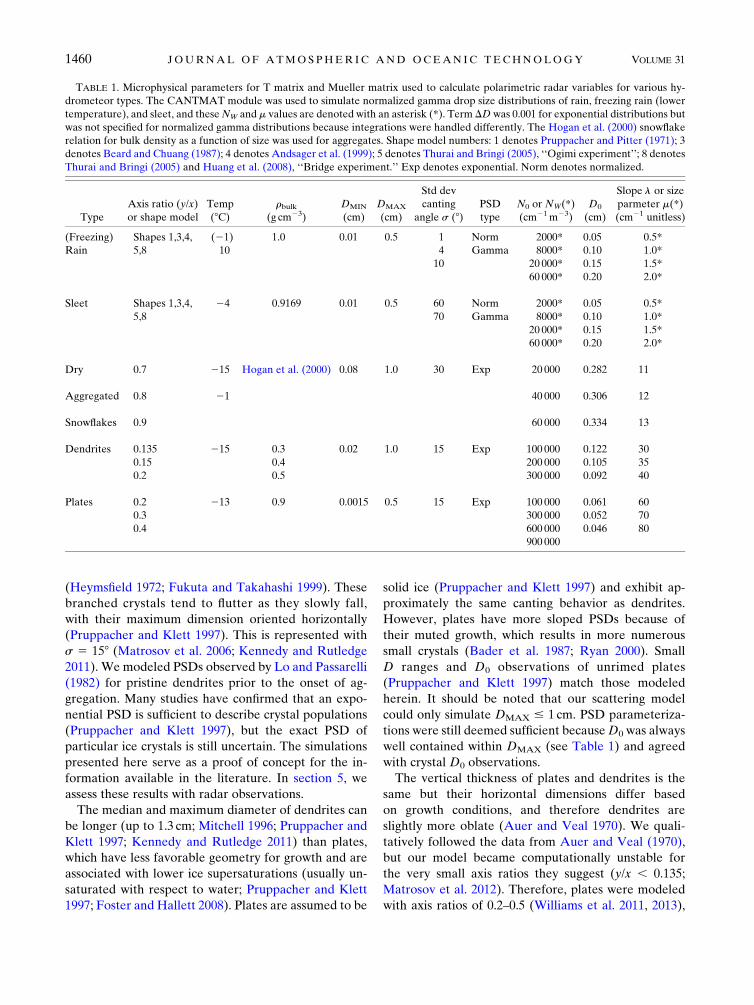
TABLE 1. Microphysical parameters for T matrix and Mueller matrix used to calculate polarimetric radar variables for various hy-
drometeor types. The CANTMAT module was used to simulate normalized gamma drop size distributions of rain, freezing rain (lower
temperature), and sleet, and theseNW and m values are denoted with an asterisk (*). Term DDwas 0.001 for exponential distributions but
was not specified for normalized gamma distributions because integrations were handled differently. The Hogan et al. (2000) snowflake
relation for bulk density as a function of size was used for aggregates. Shape model numbers: 1 denotes Pruppacher and Pitter (1971); 3
denotes Beard and Chuang (1987); 4 denotes Andsager et al. (1999); 5 denotes Thurai and Bringi (2005), ‘‘Ogimi experiment’’; 8 denotes
Thurai and Bringi (2005) and Huang et al. (2008), ‘‘Bridge experiment.’’ Exp denotes exponential. Norm denotes normalized.
Type
Axis ratio (y/x)
or shape model
Temp
(8C)rbulk
(g cm23)
DMIN
(cm)
DMAX
(cm)
Std dev
canting
angle s (8)PSD
type
N0 or NW(*)
(cm21m23)
D0
(cm)
Slope l or size
parmeter m(*)
(cm21 unitless)
(Freezing) Shapes 1,3,4, (21) 1.0 0.01 0.5 1 Norm 2000* 0.05 0.5*
Rain 5,8 10 4 Gamma 8000* 0.10 1.0*
10 20 000* 0.15 1.5*
60 000* 0.20 2.0*
Sleet Shapes 1,3,4, 24 0.9169 0.01 0.5 60 Norm 2000* 0.05 0.5*
5,8 70 Gamma 8000* 0.10 1.0*
20 000* 0.15 1.5*
60 000* 0.20 2.0*
Dry 0.7 215 Hogan et al. (2000) 0.08 1.0 30 Exp 20 000 0.282 11
Aggregated 0.8 21 40 000 0.306 12
Snowflakes 0.9 60 000 0.334 13
Dendrites 0.135 215 0.3 0.02 1.0 15 Exp 100 000 0.122 30
0.15 0.4 200 000 0.105 35
0.2 0.5 300 000 0.092 40
Plates 0.2 213 0.9 0.0015 0.5 15 Exp 100 000 0.061 60
0.3 300 000 0.052 70
0.4 600 000 0.046 80
900 000
1460 JOURNAL OF ATMOSPHER IC AND OCEAN IC TECHNOLOGY VOLUME 31

just above the 0.135–0.2 values accepted for dendrites
(Kennedy and Rutledge 2011). Both these crystal types
might have lower axis ratios in nature thanwe are able to
simulate.
2) DRY AGGREGATES
Snowflake aggregation is most prolific when temper-
atures approach 08 and 2158C because of sticking and
because dendrites are the most common components of
aggregates (Pruppacher and Klett 1997; Jiusto and
Weickmann 1973). Aggregates of these crystals can
easily exceed 2 cm, which is beyond our model’s maxi-
mum diameter. However, simulated snowflakeDMIN and
D0 values agree well with observations (Locatelli and
Hobbs 1974; Lo and Passarelli 1982; Barthazy et al. 1988;
Herzegh and Jameson 1992; Vivekanandan et al. 1994;
Spek et al. 2008). Our simulations attempted to account
for aggregation or consumption of many smaller-sized
crystals into larger ones, which produces flatter aggre-
gate PSDs compared to that of their pristine component
crystals (Spek et al. 2008; Lo and Passarelli 1982; Kennedy
and Rutledge 2011).
Hogan et al. (2000) derived a power-law relationship
for aggregates that describes rbulk as a function of size.
Clumps of dendrites with very large combined diameters
have extremely low rbulk from air pockets between
branches and since mass is distributed across a larger
volume. The majority of naturally occurring, larger ag-
gregates should have rbulk ; 0.05 g cm23, while rbulkcould range from 0.01 to 0.2 g cm23. Only the smallest,
most compact snowflakeswill approach rbulk. 0.15g cm23
(Pruppacher and Klett 1997), but they are usually re-
sponsible for the majority of positive, albeit small, Kdp
and Zdr contributions (Kennedy and Rutledge 2011;
Lautaportti et al. 2012; Andri�c et al. 2013).
Large, irregular aggregates cant or tumble more dra-
matically than pristine crystals (Kajikawa 1982). The ag-
gregate s value was accordingly doubled from that of
dendrites and plates to 308 (Matrosov et al. 2006; Kennedy
and Rutledge 2011). Instead of modeling aggregates with
very oblate axis ratios, high diameters, and an extremely
high standard deviation of canting angle (perhaps more
true to nature), their axis ratios were raised (0.7–0.9;
Barthazy et al. 1988; Vivekanandan et al. 1994; Herzegh
and Jameson 1992; Dolan and Rutledge 2009; Kennedy
and Rutledge 2011) to effectively represent a nearly
spherical particle with moderate s (manual approxima-
tion of nature). Since small ice crystals and large con-
glomerations of dendrites should have identically lowZdr
and Kdp (for different reasons), we can only distinguish
them with Zh, which alludes to their characteristically
different sizes.
3) STRATIFORM RAIN, FREEZING RAIN,AND SLEET
A normalized gamma drop size distribution (DSD) was
utilized to more accurately represent the natural vari-
ability of stratiform rain and sleet below the melting level
(Waldvogel 1974; Ulbrich 1983; Willis 1984; Bringi et al.
2003; Gibson et al. 2009). Wintertime raindrops produced
bymelted snow typically have diameters, 3mm (Stewart
et al. 1984). Both raindrops and wet snowflakes freeze
into ice pellets (IP) either individually at subzero tem-
peratures (IP-a type) or by colliding with snowflakes, ice
pellets, or other suitable freezing nuclei (IP-b type;
Th�eriault et al. 2006; Th�eriault et al. 2010). Sleet is
modeled at 248C because raindrops introduced to this
temperature should become some formof sleet (Spengler
and Gokhale 1972). Freezing rain usually begins to occur
at temperatures at or just below freezing and was mod-
eled at 218C. The stratiform rainfall DSD was used for
sleet because the parameters in Table 1 are quite broad
and previous studies have not conclusively documented
sleet’s increased maximum size or alternative PSD from
rain (Gibson et al. 2009; Stewart et al. 1990).
Raindrop-shape simulations described in Table 1 ac-
count for increasing raindrop axis ratios for D . 1mm.
Because raindrops deform into quasi-equilibrium shapes
during descent, their s values are relatively low,;18–108(Ryzhkov 2001). Ice pellets were modeled with com-
pletely frozen raindrop shapes. Gibson and Stewart
(2007) and Spengler and Gokhale (1972) indicate that
sleet’s rigid body should tumble. Correspondingly high s
values between 608 and 708 typically used for graupel
(Knight and Knight 1970; Kennedy et al. 2001) were
adopted. More complex, realistic electromagnetic scat-
tering simulations for mixtures of frozen, partially frozen,
and unfrozen drops (Fujiyoshi and Wakahama 1985) are
warranted to fully study sleet formation (Kumjian et al.
2012). However, these steps are beyond the scope of this
study, where we focus on the polarimetric signatures of
bulk hydrometeor populations and the ability of a fuzzy-
logic algorithm to distinguish them.
3. Electromagnetic scattering simulation results
Figure 1 and Table 2 show simulated Kdp, Zdr, and Zh
ranges for X, C, and S bands according to parameteri-
zations in Table 1 between five winter hydrometeor
types of interest: dendrites, plates, aggregates, sleet, and
cold-season rain. These polarimetric radar (PR) vari-
able ranges were comparable to available literature ex-
amples without major fault or disagreement (Table 3).
There is a slight, almost negligible increase in Zh and a
decrease in Zdr with increasing l for all hydrometeors
JULY 2014 THOMPSON ET AL . 1461

due to non-Rayleigh scattering effects by oblate spheroids
(Matrosov et al. 2005). This argument also justifies why
simulated X-band Kdp is actually 3.7 times greater than
at S band, but the wavelength ratio (11.0/3.2) is only 3.4
(Matrosov et al. 2005; Dolan and Rutledge 2009). As
expected, modeled rhy values for all our homogenous
hydrometer populations were above 0.99. This is a re-
flection of our idealistic model, which cannot simulate
more realistic mixtures of particles or explicitly describe
their natural variability (Balakrishnan and Zrni�c 1990).
Resonance effects (especially at C band; Zrni�c et al.
2000) are avoided in these simulations by limiting the
raindrop diameter, 5mmbased on observations (Stewart
et al. 1984).
The remainder of this section explains and justifies
these theoretical scattering simulations before discus-
sing the modifications necessary for optimal algorithm
performance on real, sometimes noisy data in section 4.
Our goal was to construct a winter HCA based on the
most current physical understanding of winter pre-
cipitation as viewed by radar instead of tuning the al-
gorithm for particular hardware or locations.
a. Dendrites and plates
Dendrites and plates both have relatively low
(,30 dBZ)Zh according to simulations, and there is some
indication that platesmight exhibit lower reflectivity than
dendrites. Our simulations of these crystals are not ex-
haustive (Table 3), but Kdp for dendrites is consistently
about 2 times greater than for plates at all ls. This was
initially counterintuitive because plates havemuch higher
bulk density and higher N0. Sensitivity studies showed
that dendrites have higherKdp primarily because they are
more oblate and haveD0 andDMAX values about twice
as large as plates. While higher-density crystals do ex-
hibit higher Kdp in our simulations, when all other
FIG. 1. Terms Kdp, Zdr, and Zh electromagnetic scattering simulations of plate crystals
(purple), dendritic crystals (blue), dry aggregated snowflakes (green), sleet (orange), and rain
(red) at X-, C-, and S-band frequency according to microphysical parameterizations in Table 1.
Note: same color conventions used throughout this study.
1462 JOURNAL OF ATMOSPHER IC AND OCEAN IC TECHNOLOGY VOLUME 31

factors remain the same, diameter is also very impor-
tant, since mass ;D3 and larger plates/dendrites are
more oblate.
While dendrites appear to have higherKdp than plates
in our simulations (Table 2; Fig. 1), as well as observa-
tions shown in section 5 and other studies (Table 3),
plates have higher simulated maximum (and minimum)
Zdr than dendrites by approximately 1.3 (0.5) dB for all
ls. This upward shift in the Zdr range was surprising,
since dendrites are more oblate, but it is reasonable
considering that plates have much higher bulk density.
This result speaks to the tendency for polarimetric var-
iables to be dependent on many, sometimes competing
physical factors. While Zh and Zdr are often derived
from Rayleigh scattering assumptions for spheres,
Rayleigh–Gans theory demonstrates that both these
variables still depend on the density and phase of oblate
hydrometeors, such as ice crystals, through the dielectric
factor (Atlas 1953).
Postive Kdp and Zdr signatures of horizontally ori-
ented crystals can systematically decrease as the radar
elevation angle increases because the radar beam is no
longer oriented along the major axis of oblate particles
(Evans and Vivekanandan 1990; Ryzhkov et al. 2005a).
Sensitivity tests for plates and dendrites between 18 and308 are shown in Table 4. Reductions in Kdp are in-
versely proportional to l, as expected according to Kdp
definitions (Bringi and Chandrasekar 2001). The
overall elevation angle effect on plates and dendrites is
to decrease maximum Kdp, as well as decrease the entire
Zdr range for each pristine crystal, making them less
distinguishable from each other, aggregates, and iso-
tropic ice crystals. Since plan position indicator (PPI)
elevation angles rarely reach 308, this effect should not
hamper most snow classification efforts except on close-
range RHI scans, as shown in section 5. The HCA
membership beta function slopes (section 4) also help
alleviate this issue. EnhancedZdr from decreasing signal-
to-noise ratio (SNR) with range, especially at pre-
cipitation echo edges, is actually more likely to degrade
algorithmperformance (Ryzhkov et al. 2005b). LowSNR
artifacts should be distinguishable frompositiveZdr areas
associated with oriented ice crystals because only the
latter will follow meteorological storm evolution.
In summary, the microphysical differences between
plates and dendrites are manifested in radar data by an
TABLE 2. TermsKdp, Zdr, and Zh electromagnetic scattering simulation ranges, i.e., [min, max] rounded to three significant figures, for
plate ice crystals, dendritic crystals, dry aggregated snowflakes, sleet, and rain atX-, C-, and S-band frequencies according tomicrophysical
parameterizations in Table 1.
Variable Wavelength Plates Dendrites Aggregates Sleet Rain
Zh X [21.01, 18.6] [9.94, 28.5] [22.6, 31.3] [217.5, 40.2] [210.3, 49.5]
C [21.00, 18.7] [10.1, 28.8] [23.2, 31.9] [217.5, 40.2] [210.3, 49.4]
S [20.99, 18.7] [10.2, 30.0] [23.3, 32.1] [217.5, 40.2] [210.3, 47.8]
Zdr X [1.83, 5.24] [1.35, 3.96] [0.01, 0.08] [0.00, 0.44] [0.04, 2.56]
C [1.83, 5.22] [1.35, 3.92] [0.01, 0.07] [0.00, 0.42] [0.04, 2.23]
S [1.83, 5.22] [1.35, 3.90] [0.01, 0.07] [0.00, 0.41] [0.04, 2.01]
Kdp X [0.01, 0.91] [0.04, 1.98] [0.00, 0.10] [0.00, 0.32] [0.00, 3.54]
C [0.01, 0.53] [0.03, 1.15] [0.00, 0.05] [0.00, 0.17] [0.00, 2.36]
S [0.01, 0.26] [0.02, 0.57] [0.00, 0.03] [0.00, 0.09] [0.00, 1.01]
TABLE 3. References for verifying and modifying scattering simulation results in Figs. 1 and 2 as well as Table 2, specified by hydro-
meteor category and radar wavelength, as shown by parentheses ( ). The asterisk denotes that Straka et al. (2000) described a combination
(combo) snow–crystal category that exhibited Zdr consistent with plates but Kdr more consistent with dendrites. However, this study
distinguishes between the two crystal types.
Dendrites Plates Aggregates Sleet Rain
Straka et al. 2000 (S)
combo snow*
Straka et al. 2000 (S)
combo snow*
Straka et al. 2000 (S) Kumjian et al. 2013 (C/S) Straka et al. 2000 (S)
D , 3mm
Trapp et al. 2001 (S) Wolde and Vali 2001 (X) Ryzhkov et al. 2005a (S) Bringi and Chandrasekar
2001 (X/C/S)
Ryzhkov et al. 2005a (S) Williams et al. 2011,
2013 (C)
Dolan and Rutledge
2009 (X/S)
Dolan and Rutledge
2009 (X/S)
Kennedy and Rutledge
2011 (S)
Andri�c et al. 2013 (X/C/S)
JULY 2014 THOMPSON ET AL . 1463

inverse Kdp–Zdr relationship, which may help distin-
guish the two categories. This is promising because snow
crystals always have relatively lowZh and high rhy. Some
observations of slightly reduced rhy to 0.90 within DGZs
have been reported (Kennedy and Rutledge 2011;
Andri�c et al. 2013), perhaps due to PSD broadening,
varying densities, as well as varying crystal shapes and
therefore a wider spectrum of fall behavior under
vigorous vapor deposition. Since this small magnitude
rhy decrease is not seemingly present in every DGZ
because it is hardly measurable and may depend on the
intensity of crystal growth, it is not accounted for in this
algorithm.
b. Dry aggregates
Aggregates have extremely lowmagnitudeKdp andZdr
because of low rbulk and increased canting. However,
they also have the highest Zh compared to plates, den-
drites, or any other ice crystals because of their larger
diameters (Ohtake and Henmi 1970; Ryzhkov and Zrni�c
1998; Boucher and Wieler 1985). Trapp et al. (2001) and
Ryzhkov et al. (2005b) propose thatZdr tends to decrease
as Zh increases, or as aggregation progresses, density
decreases, and fall behavior becomes more erratic. Our
simulations also suggest a minimum reflectivity value
associated with aggregates near 20dBZ, which is used to
differentiate aggregates from individual, nonoriented,
small ice crystals in section 4. Texture fields (Ryzhkov
et al. 2005a) could potentially be implemented in the
future to detect the Zh gradient often associated with
aggregating dendrites (Kennedy and Rutledge 2011).
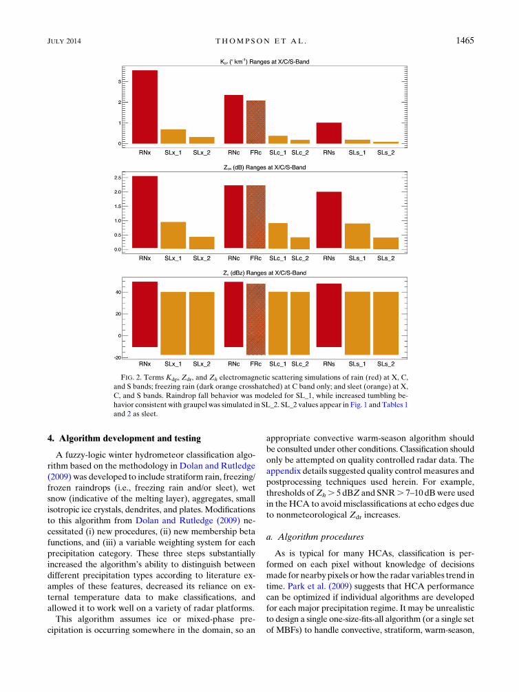
c. Stratiform rain, freezing rain, and sleet
Sleet has lower Kdp, Zdr, and Zh than rain (Fig. 1) be-
cause of increased canting as well as decreased dielectric
factor of ice compared to liquid water. Figure 2 shows the
results of anX-, C-, and S-band sensitivity study conducted
to isolate the relative impacts of these factors on radar
variables for rain (RN), freezing rain (FR; T 5 218C,only at C band as a proof of concept), and sleet [version
1 (SL_1) or version 2 (SL_2)]. Not surprisingly, freezing
rain is barely distinguishable from rain (2-dBZ Zh de-
crease, noZdr change, and only 0.038km21Kdp decrease
at C band from rain to sleet), which leads us to conclude
that temperature has only a minor effect on these sim-
ulations. Simulating frozen raindrops with decreased
dielectric factor, density, and temperature without
tumbling fall behavior (SL_1) resulted in a substantial
7-dBZ decrease, 1.4-dBZdr decrease, as well as 1.5, 1.25,
and 1.08 km21 Kdp decrease for X, C, and S bands
compared to rain, respectively. When ice pellets were
more realistically allowed to tumble (SL_25 version of
sleet used in Fig. 1 and the rest of this study), the addi-
tional decrease in Zh is nearly zero, but there is a 25%
further decrease in themaximumKdp andZdr.While it is
obvious that these three radar variables should decrease
once rain has completely frozen, these findings show that
the dielectric factor and density decrease from liquid to
ice dominates these trends; that canting has a secondary,
nonnegligible effect; and that temperature makes little
individual contribution.
More importantly, since Figs. 1 and 2 show how radar
variables associated with stratiform rain encompass that
of both supercooled (freezing) and frozen rain (sleet),
these latter two phenomena could simply be attributed
to light rain. If the expected value ranges of a hydro-
meteor type are not unique from another type, then
fuzzy-logic HCA MBFs cannot distinguish them. This
simple algorithm also cannot accommodate detection of
the localized, small magnitude refreezing signature as-
sociated with the production of sleet because those ex-
pected value ranges also lie within that of stratiform rain
(Kumjian et al. 2013). These include a localized increase
in Zdr and Kdp along with decreased rhy and Zh. If 2D
MBFs (Zrni�c et al. 2001) and/or texture fields (Ryzhkov
et al. 2005a) were incorporated into the HCA, then
the spatially correlated variability of rhy, Zdr, Kdp, and
Zh within the refreezing signature might prompt more
accurate rain/freezing rain/sleet classification. In the
meantime, our methodology relies primarily on tem-
perature to classify rain and the combined possibility of
sleet and/or freezing rain below the melting layer, where
T , 08C, without assessing other possible thermody-
namic factors as in Schuur et al. (2012).
TABLE 4. Terms Kdp and Zdr electromagnetic scattering simu-
lation ranges, i.e., [min, max] rounded to three significant figures, at
18 and 308 radar elevation angles for plates and dendrites at X-, C-,
and S-band frequency according to microphysical parameteriza-
tions in Table 1. Elevation-induced Zdr changes were not signifi-
cantly different between X, C, and S bands. The [Dmin, Dmax]
represents the differences in simulated ranges with increasing el-
evation angle from 18 to 308.
Category Plates
18 (Elev angle) 308 (Elev angle) [Dmin, Dmax]
Zdr X/C/S [2.65, 5.22] [1.83, 3.50] [20.82, 21.72]
Kdp X [0.01, 0.91] [0.01, 0.68] [0.00, 20.23]
C [0.01, 0.53] [0.01, 0.38] [0.00, 20.15]
S [0.01, 0.26] [0.01, 0.19] [0.00, 20.07]
Category Dendrites
18 (Elev angle) 308 (Elev angle) [Dmin, Dmax]
Zdr X/C/S [2.2, 3.92] [1.35, 2.7] [20.85, 21.22]
Kdp X [0.05, 1.98] [0.04, 1.49] [0.01, 20.49]
C [0.03, 1.15] [0.03, 0.87] [0.01, 20.28]
S [0.02, 0.57] [0.02, 0.42] [0.01, 20.15]
1464 JOURNAL OF ATMOSPHER IC AND OCEAN IC TECHNOLOGY VOLUME 31
4. Algorithm development and testing
A fuzzy-logic winter hydrometeor classification algo-
rithm based on the methodology in Dolan and Rutledge
(2009) was developed to include stratiform rain, freezing/
frozen raindrops (i.e., freezing rain and/or sleet), wet
snow (indicative of the melting layer), aggregates, small
isotropic ice crystals, dendrites, and plates. Modifications
to this algorithm from Dolan and Rutledge (2009) ne-
cessitated (i) new procedures, (ii) new membership beta
functions, and (iii) a variable weighting system for each
precipitation category. These three steps substantially
increased the algorithm’s ability to distinguish between
different precipitation types according to literature ex-
amples of these features, decreased its reliance on ex-
ternal temperature data to make classifications, and
allowed it to work well on a variety of radar platforms.
This algorithm assumes ice or mixed-phase pre-
cipitation is occurring somewhere in the domain, so an
appropriate convective warm-season algorithm should
be consulted under other conditions. Classification should
only be attempted on quality controlled radar data. The
appendix details suggested quality control measures and
postprocessing techniques used herein. For example,
thresholds ofZh. 5 dBZ and SNR. 7–10 dBwere used
in the HCA to avoidmisclassifications at echo edges due
to nonmeteorological Zdr increases.
a. Algorithm procedures
As is typical for many HCAs, classification is per-
formed on each pixel without knowledge of decisions
made for nearby pixels or how the radar variables trend in
time. Park et al. (2009) suggests that HCA performance
can be optimized if individual algorithms are developed
for eachmajor precipitation regime. It may be unrealistic
to design a single one-size-fits-all algorithm (or a single set
of MBFs) to handle convective, stratiform, warm-season,
FIG. 2. Terms Kdp, Zdr, and Zh electromagnetic scattering simulations of rain (red) at X, C,
and S bands; freezing rain (dark orange crosshatched) at C band only; and sleet (orange) at X,
C, and S bands. Raindrop fall behavior was modeled for SL_1, while increased tumbling be-
havior consistent with graupel was simulated in SL_2. SL_2 values appear in Fig. 1 and Tables 1
and 2 as sleet.
JULY 2014 THOMPSON ET AL . 1465

and cold-season precipitation. Thus, our HCA is designed
for stratiform winter precipitation. We explain our meth-
odology with a freezing rain case study using the C-band
University of Oklahoma Polarimetric Radar for In-
novations inMeteorology andEngineering (OU-PRIME)
radar in Norman, Oklahoma (Palmer et al. 2011). The
nearby soundings for this event are shown in Fig. 3, which
exhibit a strong temperature inversion and a cold surface
layer from 1500 until 2100 UTC. Figure 4 shows the 2.98PPI of OU-PRIME C-band polarimetric radar variables
through the melting layer when METARs indicated
freezing rain at the surface. A region of enhanced Kdp
and slightly reduced rhy appears aloft toward the south-
west, but Zdr is generally#1.25dB. This could potentially
be a weak dendritic growth zone. This particular radar
scan was used to verify that the algorithm could handle
certain peculiarities and classification difficulties such as
a slanted melting-layer height from west-northwest to
south-southeast throughout the domain, nonuniform
precipitation, and less prominent DGZ signatures.
The complete classification algorithm includes three
individual HCAs with different categories that are used to
inform a final fourth classification based on melting-layer
detection. The fourHCAsteps completed for data in Fig. 4
are illustrated in Fig. 5. First, the melting-layer detection
HCA in Fig. 5a distinguishes wet snow (WS) from the
other category (OT), which could be aggregates, isotropic
ice crystals, or light rain. Melting-layer classification on
these wet snow pixels with relatively high SNR (.10dB)
is handled with the same general methodology presented
byGiangrande et al. (2008) to account for variablemelting-
layer heights in each 108 azimuthal sector of a PPI or for
a single RHI. Following themethodology ofGiangrande
et al. (2008) and Boodoo et al. (2010), the melting-layer
top, median, and base are defined by the heights (AGL)
below which 80%, 50%, and 20%, respectively, of all
wet snow gates reside in each sector. Only wet snow
pixels between the 5–35-km range are used to determine
these melting-layer (ML) height statistics to avoid
nonuniform beam filling (Ryzhkov 2007), other sam-
pling errors that degrade the quality of polarimetric
variables at extremely close and far ranges, and any
substantial beam ascent with range.
To detect precipitation transition events where the
ML reaches the ground, ML height was also allowed to
vary with range along a single PPI azimuth or RHI. For
both the azimuth- and range-dependent methodologies,
wet snow pixels are interrogated at all vertical levels of
the radar volume because ground clutter is presumably
removed a priori. To this end, a number of wet snow
pixels (MLnum) from the near-radar high-quality data
range are used to estimate the degree of melting
(Giangrande et al. 2008) within a particular azimuth
sector and/or range segment of the bright band. This
MLnum threshold is subjective and depends on the ra-
dar’s data quality and spatial resolution. Thresholds
were tested with surface observations during precipi-
tation transition events. For example, OU-PRIME and
the Colorado State University–University of Chicago–
Illinois State Water Survey (CSU–CHILL) RHIs have
very high spatial resolution, so complete melting along
the azimuth/range segment was assumed to occur if
MLnum . 10 000; no melting was deemed to occur if
MLnum , 100; and partial melting was assumed to
happen when 100 , MLnum , 10 000, such that snow
made it to the ground but there was still a temperature
inversion aloft. These melting scenarios are used to in-
form the next HCA steps.
In the case of complete melting, a below-ML HCA
defines rain (RN) and freezing/frozen rain (FZ) based
on temperature and Zh below the melting-layer median
height, as shown in Fig. 5b, which uses the 1500 UTC
sounding from Fig. 3a. Next,Kdp,Zdr, andZh are used to
FIG. 3. Skew T diagrams from KOUN, nearly collocated with
OU-PRIME. OUN surface precipitation type was freezing rain at
1500 and 1800 UTC but sleet at 2100 UTC.
1466 JOURNAL OF ATMOSPHER IC AND OCEAN IC TECHNOLOGY VOLUME 31

classify dendrites, plates, ice crystals, and aggregates
above the ML in Fig. 5c. A possible DGZ with aggre-
gation below was identified in the southwest domain
amid ice crystals. The DGZ is appropriately contained
within 258 to 2158C according to the 1500 UTC
sounding. TermKdp within this potential DGZ reached
1.78 km21, which was 0.68km21 higher than the maxi-
mum value estimated by C-band scattering simulations.
This is likely because our model could not simulate axis
ratio , 0.135, D . 1 cm, and some riming could be oc-
curring.
Now theMLnum is used to inform the finalHCA,Fig. 5d.
If no melting is detected, then the above-ML HCA is
applied everywhere. If partial melting occurs, then the
above-MLHCA is used throughout the domain, but the
ML is painted into the classification for reference. If
completemelting occurs, then the above- and below-ML
HCAs are stitched together above and below the ML
median height along with the wet snow pixels from the
ML detection HCA, as shown in Fig. 5d.
b. Membership beta functions
The categories in each HCA step are assigned a score
depending on the radar variables’ fit into that category’s
MBF, which is defined by its center value (m), half-width
(a), and slope (b). Each radar variable in an MBF is
assigned a weight (w: 0%–100%) in calculating the
score. The hydrometeor category with the highest score
is determined to be the dominant bulk hydrometeor type
of a particular radar gate. The expected value ranges of
plates, dendrites, aggregates, sleet, and rain in Fig. 1 and
Table 2 were modified to produce the ML detection,
FIG. 4. C-band OU-PRIMEZh, Zdr,Kdp, and rhy PPI scans at 2.98 elevation angle through stratiform precipitation
with a possible dendritic growth zone aloft toward the southwest at 1545 UTC 28 Jan 2010 when OUN METAR
reported freezing rain at the surface. The triangle represents the radar location.
JULY 2014 THOMPSON ET AL . 1467

above-ML, and below-ML HCA MBFs in Figs. 6–8 and
Table 5 as follows:
1) Implement b parameters to gradually widen the
MBFs but preserve the boundaries between cate-
gories predicted by scattering simulations.
2) IncreasemaximumZdr for aggregates to 1 dB,which is
regarded as acceptable for classification purposes
considering noise, uncertainty, and the varying degree
of aggregation byBader et al. (1987), Illingworth et al.
(1987), and Straka et al. (2000).
3) For the same reasoning as item 2, increase maximum
aggregate Kdp values incrementally for decreasing l.
These increments were subjectively derived and
tested with the case studies in section 5.
4) Decrease minimum Zdr for aggregates to 21 dB to
accommodate cases of differential attenuation above
the melting layer and noise.
5) Increase maximum Zdr for plates and maximum Kdp
for dendrites based on our case studies and literature
radar observations (Table 3) to account for larger
diameter crystals than could be parameterized in our
model, or other possible model uncertainties.
6) Slightly decrease the minimum Zh allowed for den-
drites and slightly increase the maximum Zh allowed
for plates and aggregates to match radar observation
examples herein and in Table 3.
The wet snow MBF (Fig. 6) is substantially wide to ac-
count for noise, non-Rayleigh scattering, and differential
FIG. 5. Winter hydrometeor classification algorithm steps: (a) ML detection, (b) below-ML, (c) above-ML, and
(d) final HCA output for same C-band OU-PRIME PPI scans in Fig. 4. Final classification includes plates (PL: purple),
dendrites (DN: blue), ice crystals (IC: pink), dry aggregated snowflakes (AG: green), wet snow (WS: yellow),
freezing/frozen raindrops (FZ: orange), rain (RN: red), and not available (N/A: white) indicating clear air or ground
clutter. The triangle represents the radar location.
1468 JOURNAL OF ATMOSPHER IC AND OCEAN IC TECHNOLOGY VOLUME 31

attenuation based on Knight (1979), Fujiyoshi (1986),
Barthazy et al. (1988), Zrni�c et al. (1993), Vivekanandan
et al. (1993), Ryzhkov and Zrni�c (1998), Straka et al.
(2000), Brandes and Ikeda (2004), and Dolan et al.
(2013). We implemented overlapping rhy MBFs be-
tween wet snow (0.6–0.95; Illingworth and Caylor 1989;
Ryzhkov and Zrni�c 1998; Straka et al. 2000) and other
hydrometeors (0.90–1.0) based on trial and error efforts
to reduce misclassification of noise or dendrites as wet
snow, especially within/around the ML where bright-
band signatures are not exactly collocated (Brandes and
Ikeda 2004).
Simulated aggregates appear to have a lower limit
of reflectivity near 23 dBZ and previous studies have
shown that other small, individual, nonoriented ice
crystals may have reflectivities up to 15 dBZ (Dolan and
Rutledge 2009). Therefore, we applied a switchover
point between the aggregated snowflake and ice crystal
membership beta functions between 15 and 20 dBZ. The
same Zdr and Kdp MBFs for aggregates (low magnitude
but widened to account for noise) are used for isotropic
ice crystals. This is illustrated in Fig. 8.
c. Variable weighting system
The variable weighting system was motivated by the
scattering simulations and observations, which show
that certain radar variables are inherently more useful in
distinguishing certain hydrometeor types. Dolan and
Rutledge (2009) use variable weights for each radar
variable (depending mostly on data quality), which were
applied to all their hydrometer categories. Using their
same equations, we implement various weights depending
on the radar variable, situation, and hydrometeor. This is
a subjective version of confidence vectors from Park et al.
(2009). Algorithm performance was very sensitive to small
(5%) changes in the weighting system and those listed in
Table 5 gave the most physically realistic results. When
testing the weights, we ensured that the algorithm could
FIG. 6. X-, C-, and S-band MBFs for the ML detection HCA. Categories include wet snow and
other, which accounts for aggregates, ice crystals, and/or light rain.
FIG. 7. X-, C-, and S-band MBFs for the HCA used below the ML. Categories include
freezing/frozen rain and rain.
JULY 2014 THOMPSON ET AL . 1469

consistently identify the radar bright band, dendritic
growth zone, aggregates, etc., where applicable and in-
dicated by other observations throughout the entirety of
our four case studies (section 5). It is significant that the
weighting system in Table 5 works well on four different
radar platforms at X, C, and S bands during four unique
winter storms, as demonstrated in section 5.
The weights allow the algorithm to capitalize on
strengths of specific radar variables in differentiating
between certain hydrometeors. For example, rhy is
heavily weighted for wet snow identification, but not
100% because the rhy ML signature is quite narrow and
increased weighting. 56% resulted in misclassifications.
TermZdr was weighted second highest for ML detection.
Figure 4 shows how the Zh brightband signature is not
always consistent or well defined inwintertime. TermKdp
is not trustworthy in and around the ML, so it was ex-
cluded from the ML detection algorithm.
TermsKdp andZdr are themost important and heavily
weighted variables for distinguishing dendrites, plates,
and aggregates, since rhy and Zh are usually innocuous
(Trapp et al. 2001). However, Zh was weighted highest
FIG. 8. X-, C-, and S-band MBFs for the above ML HCA. Categories include dry aggregated snowflakes, ice crystals, dendrites,
and plates.
TABLE 5. MBF weights (w), slope (b), and center (m)6 half-width (a) parameters as well as resultant expected value ranges for X-, C,
and S-band plates (PL), dendrites (DN), ice crystals (IC), dry aggregated snowflakes (AG), wet snow (WS), other (OT), rain (RN), and
freezing/frozen raindrops (FZ).MBFs are wavelength independent unless otherwise noted. The finalHCAuses the below- and above-ML
HCAs according to how much melting is estimated to occur from the ML detection HCA.
HCA Step ML detection HCA Below-ML HCA Above-ML HCA
Variable MBF OT WS FZ RN PL DN IC AG
Zh w, b 16%, 5 10, 16% 33%, 15 33%, 15 20%, 10 20%, 5 48%, 5 24%, 10
m 6 a 16 6 17 25 6 20 116 196 12 6 13 17 6 14 6 6 11 28 6 12
[min, max] [21,33] [5,45] [217,39] [211,49] [21,25] [3,31] [25,17] [16,40]
Zdr w, b 28%, 15 28%, 10 — — 36%, 10 36%, 10 24%, 20 36%, 20
m 6 a 0.5 6 1.5 25 6 20 5.5 6 3.7 2.6 6 1.3 0 6 1 0 6 1
[min, max] [40,6] [40,6] [1.8,9.2] [1.3,3.9] [21,1] [21,1]
Kdp w, b — — — — 44%, 5 44%, 5 28%, 5 40%, 5
X: m 6 a 0.46 6 0.45 1.32 6 1.28 0 6 0.55 0 6 0.55
[min, max] [0,0.9] [0.04.2.6] [20.55,0.55] [20.55,0.55]
C: m 6 a — — — — 0.27 6 0.26 1.0 6 0.7 0 6 0.325 0 6 0.325
[min, max] [0,0.53] [0.03,1.7] [20.325,0.325] [20.325,0.325]
S: m 6 a — — — — 0.13 6 0.13 0.31 6 0.3 0 6 0.2 0 6 0.2
[min, max] [0,0.26] [0.01,0.61] [20.2,0.2] [20.2,0.2]
rhy w, b 56%, 10 56%, 30 — — — — — —
m 6 a 0.96 6 0.06 0.75 6 0.2
[min, max] [0.90,1.00] [0.55,0.95]
T (8C) w, b — — 66%, 20 66%, 40 — — — —
m 6 a — — 24 6 3 25 6 25
[min, max] [27,21] [0,50]
1470 JOURNAL OF ATMOSPHER IC AND OCEAN IC TECHNOLOGY VOLUME 31

for the ice crystal category in order to differentiate from
aggregates. The algorithm produced the most physically
consistent results when Kdp was weighted slightly more
thanZdr for classifying dendrites, plates, aggregates, and
isotropic ice crystals. We presume that Kdp is less af-
fected by aggregation and radar calibration than Zdr
(Vivekanandan et al. 1994), so it is perhaps a better in-
dicator of pristine, oriented crystals.
Temperature dominates the classification between
freezing/frozen and liquid rain, but contrary to most
previous HCAs, temperature is not included in any
other decision process.We abandoned this temperature-
dependent methodology early on because it tended
to produce horizontally stratified, nonmeteorological
crystal classifications above the melting layer. Dendritic
and plate growth zone classification examples using
polarimetric radar (supported by surface observations
and sounding information aloft) within this study and
others suggest that plates occur in a ‘‘cocoon’’ (Williams
et al. 2011, 2013) near the top of the radar echo, while
dendrites tend to be found in a ‘‘pocket’’ contained
within the echo surrounded by decreasing values of Kdp
and Zdr (Kennedy and Rutledge 2011; Andri�c et al.
2013). Aggregates seem most prevalent below dendritic
growth zones. Otherwise, small, individual, nonoriented
ice crystals are ubiquitous. Aircraft observations of en-
vironmental conditions and precipitation type would
provide further in situ algorithm validation of these
phenomena.
5. Hydrometeor classification algorithm casestudies
This winter HCA was tested on four different po-
larimetric radars spanning three different frequencies:
C-band OU-PRIME (Palmer et al. 2011) and X-band
Collaborative Adaptive Sensing of Atmosphere (CASA)
radars in central Oklahoma (McLaughlin et al. 2009;
Junyent et al. 2010); an S-band Polarimetric Weather Sur-
veillance Radar-1988 Doppler (WSR-88DP) in Wichita,
Kansas; and the dual-wavelength X- and S-band CSU–
CHILL radar in northern Colorado (Brunkow et al.
2000). See the appendix for radar data postprocessing
details. Observations from four different winter storms
are now considered to demonstrate the algorithm’s
utility.
FIG. 9. C-bandOU-PRIMEZh,Zdr, rhy, andHCA3308RHI scans at 2220UTC 28 Jan 2010 through stratiformprecipitation once sleet had
been reported in the Oklahoma City, OK, area by METAR.
JULY 2014 THOMPSON ET AL . 1471

a. 28 January 2010 Oklahoma ice storm
Freezing rain occurred throughout most of Oklahoma
for nearly 6 h during an ice storm on 28 January 2010.
Snow was falling through a strong inversion aloft, which
descended and cooled slightly over the course of the
soundings in Figs. 3a–c. Wet snow pixels from the
ML HCA exhibited decreasing mean rhy from 1800 to
2300 UTC as the surface precipitation type switched
from freezing rain to sleet around 2100 UTC according
to METARs. The HCA indicated melting-layer depth
also increased over time (determined by wet snow
pixels within the 5–25-km range to avoid nonuniform
beam filling; see section 4). One HCA RHI during
these interesting ML trends is shown in Fig. 9. Much of
the original melting-layer structure is preserved in the
wet snow classification through diligent weighting of
the polarimetric variables. Some aggregates are iden-
tified just above the ML but ice crystals are found
where Zh , 15 dBZ. The most recent sounding helps
classify either rain or freezing/frozen raindrops below
the ML. The HCA shows some wet snow pixels de-
scending below the ML, perhaps contributing toward
or showing evidence of the transition from freezing rain
to sleet observed by other means. A refreezing signa-
ture consistent with Kumjian et al. (2013) appeared in
an alternate region of the OU-PRIME domain from
2100 to 2300 UTC around the coldest sounding tem-
perature level. As previously discussed, the algorithm
presented herein is not capable of identifying the re-
freezing signature but it is nonetheless an important
phenomenon relevant to this study that should be in-
cluded in future winter HCAs (Stewart 1992; Heymsfield
et al. 2004; Schuur et al. 2012).
b. 24 December 2009 Oklahoma blizzard
A transition zone from convective rain to snow asso-
ciated with a vertical bright band (Stewart 1992) prop-
agated eastward through central Oklahoma prior to
FIG. 10. X-band CASA KSAO (Chickasha, OK) Zh, Zdr, rhy, and HCA 2708 RHI scans at 1422 UTC 24 Dec 2009 perpendicular to
a vertical bright band. Freezing rain and sleet were classified between 0- and 10-km range with intermittent wet snow. A concentrated
region of wet snowflakes reached the ground around 10–12-km range. Dry aggregated snowflakes and then ice crystals are indicated at
farther ranges. Central and southwestern Oklahoma METAR reports confirmed passage of a similar precipitation transition event be-
tween 1400 and 1600 UTC.
1472 JOURNAL OF ATMOSPHER IC AND OCEAN IC TECHNOLOGY VOLUME 31

blizzard conditions on 24 December 2009. The vertical
bright band was easily detected in a CASA radar RHI
(reconstructed from PPIs) as a vertically coherent re-
gion of wet snow extending toward the ground in Fig. 10
between the 10–12-km range. The HCA analysis
matched METAR observations at the radar site as the
vertical bright band surged southeastward. Rain was
reported at first, then a transition to freezing rain, sleet,
and some instances of snow were observed in advance of
the main vertical bright band (10–12-km range), with
snow consistently falling in the colder air beyond. This
illustrates the ability of the algorithm to differentiate
heavy rain from wet snow, both of which can produce
highZh andZdr but have very different rhy. Figure 10 also
shows the melting-layer detection algorithm’s versatility
in identifying a descending bright band by accounting for
varying ML heights with range (based on the degree of
melting found in each 2-km segment of this RHI; see
section 4). Rain and sleet were classified as a function of
temperature and therefore height using the 1200 UTC
upstream KOUN (Norman) sounding. A refreezing sig-
nature indicative of sleet as described in Kumjian et al.
(2013) was briefly observed ahead of the vertical
brightband passage near the 08C level in a different radar
scan (not shown), but the algorithm did not correctly
classify this near-surface process as previously explained.
Once the surface precipitation type changed to snow
within the CASA radar network over the next hour,
particularly high Kdp up to 2.68 km21 was observed
within a classic DGZ in Fig. 11. This exceeded the
maximum X-band Kdp simulated for dendrites by
0.68km21, perhaps because these dendrites exceeded the
maximum diameter allowed in our scattering model
(1 cm), were more oblate, had different PSDs, or were of
greater density than modeled. The high Kdp, high Zdr
pocket, and HCA dendrite identification in Fig. 11
were collocated with the2158C isotherm from a nearby
sounding taken 3 h prior. Wet snow is included in this
HCA because a temperature inversion was still present
but obviously not strong enough to prevent snow from
reaching the ground according to surface observations.
Aggregation is most likely occurring near the Zh gra-
dient below the DGZ, but Kdp and Zdr are still high
enough to warrant dendrite classification instead of
aggregates until ;1 km above the radar bright band.
Aggregates appear to reach the ground, which matches
FIG. 11. X-band CASAKCYR (Cyril, OK) Zh, Zdr,Kdp, and HCA 508RHI scans at 1518 UTC 24 Dec 2009 through a dendritic growth
zone aloft when Lawton and Chickasha, OK, METAR snow reports occurred at the surface within this vicinity. A temperature inversion
existed around 1 km but did not cause complete melting. 1200 UTC OUN (Norman, OK) sounding isotherms.
JULY 2014 THOMPSON ET AL . 1473

surface observations of heavy snowfall and suggests the
role of dendrites aloft in promoting aggregation zones
(Kennedy and Rutledge 2011). Ice crystals are only
classified on the low Zh peripheries of this storm.
c. 7–8 February 2012 Great Plains snowstorm
The sole case study of platelike crystals available to us
was provided by personal identification of hexagonal
plates at the surface within range of the Wichita WSR-
88DP radar (T. Dewvall, Accuweather Enterprise So-
lutions, Inc., 2012, personal communication). Figure 12
shows a reconstructed vertical cross section into the
region classified as plates, which appear to fall toward
the surface. Wichita sounding temperature ranges were
suitable for plate growth throughout this region. Ex-
tremely high Zdr values (6.7 dB) were observed within
the plate classification whereKdp, 0.258km21 andZh,20 dBZ, which matches plate scattering simulations of
Kdp and Zh, respectively, but exceeds the simulated
plate Zdr value by 1.5 dB. This indicates that our model
parameterizations for plates might not have been oblate
enough, or with the correct PSD. Term Zdr should in-
crease as crystals attain higher densities or take on
a more oblate, solid habit. Ice crystals were reasonably
classified elsewhere, with some higher reflectivity values
near the ground prompting identification of aggregates.
Some dendrite classifications are made between isotropic
crystal and plate regions, perhaps indicating a natural
transition between the snow types according to varying
environmental moisture content and temperature.
d. 3 February 2012 Colorado snowstorm
To demonstrate algorithm performance at various
wavelengths, simultaneous, dual-wavelength observa-
tions of a Colorado snowstorm were analyzed with the
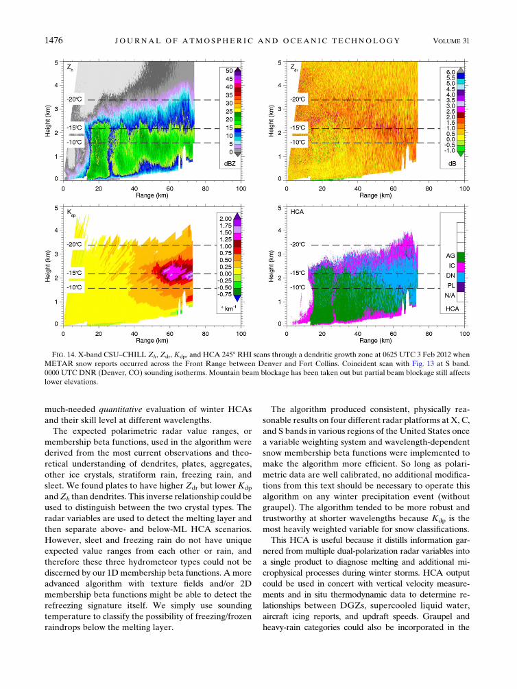
CSU–CHILL radar. When the dendritic growth zone
signature was most established within range of both
wavelength systems, the S-band RHI (Fig. 13) showed
Kdp ;0.68km21, while the X-band RHI (Fig. 14) ex-
hibited values correspondingly 3.7 times greater near
2.28 km21. Note the proximity of this DGZ to the
mountains, blocked out in white, and the potential el-
evation angle induced Kdp reductions close to the ra-
dar, where the DGZ might still exist. Maximum Zdr is
between 2.5 and 3.0 dB and actually intersects the beam
blockage in the S-band scan. Aggregates are identified
FIG. 12. S-band KICT (Wichita, KS)Zh,Zdr,Kdp, and HCA 278RHI scans at 0132 UTC 8 Feb 2012 through a supposed plate growth zone
when platelike snow crystals were sighted at the ground in Wichita. 0000 UTC ICT (Wichita) sounding isotherms.
1474 JOURNAL OF ATMOSPHER IC AND OCEAN IC TECHNOLOGY VOLUME 31
below the DGZ, where both Kdp and Zdr decrease to-
ward zero but Zh remains high. A reasonable mixture
of isotropic ice crystals and dendrites is suggested near
echo top in regions of low Zh, potentially where ice
germs are growing to appreciable size in conditions
favorable for rapid vapor deposition.
Nearly equivalent X- and S-band classifications of
dendrites centered directly on the 2158C level were
made possible by the l-dependent HCA MBFs but with
the same weighting system used at all wavelengths. The
HCA is able to distinguish between snow types at S band
despite the low Kdp magnitudes at this l, which is
encouraging since this is the operating frequency of
the WSR-88DPs. However, the higher-resolution and
shorter-wavelength information offered by X band in
this series of simultaneous CHILL RHIs is more dis-
criminatory, so the X-band HCA seems more trust-
worthy.While theX-bandCHILL systemhas a beamwidth
3 times narrower than at S band (0.38 vs 18), we believe
the wavelength dependence of Kdp has a greater impact
on the differing crystal classifications between Figs. 13
and 14. Higher-magnitude phase shifts may be detected
at X band because they stand out more from inherent
Fdp statistical noise (Matrosov et al. 2005). As an ex-
ample, Fig. 11 from an X-band CASA radar, which has
a wide 1.88 beamwidth, also seemed to offer more in-
formation about the location of hydrometer transition
zones due to strong Kdp signatures.
6. Conclusions
The simple fuzzy-logic polarimetric radar hydrome-
teor classification algorithm developed herein reveals
five important microphysical features in winter storms
without external temperature information: 1) dendritic
and 2) plate crystal growth zones, 3) snowflake aggre-
gation, 4) finescalemelting-layer fluctuations, and 5)ML
descent into a vertical bright band. These phenomenawere
consistent with sounding data and surface observations
where available, but experiments with more in situ
measurements should be performed. Furthermore, the
national upgrade of S-band NEXRAD radars should
offer more case studies with which to better understand
winter storm polarimetric signatures and provide a
FIG. 13. S-band CSU–CHILL Zh, Zdr, Kdp, and HCA 2458 RHI scans through a dendritic growth zone at 0625 UTC 3 Feb 2012 when
METAR snow reports occurred across the Front Range between Denver and Fort Collins, CO. Coincident scan with Fig. 14 at X band. 0000
UTCDNR(Denver) sounding isotherms.Mountain beamblockage has been taken out but partial beamblockage still affects lower elevations.
JULY 2014 THOMPSON ET AL . 1475
much-needed quantitative evaluation of winter HCAs
and their skill level at different wavelengths.
The expected polarimetric radar value ranges, or
membership beta functions, used in the algorithm were
derived from the most current observations and theo-
retical understanding of dendrites, plates, aggregates,
other ice crystals, stratiform rain, freezing rain, and
sleet. We found plates to have higher Zdr but lower Kdp
andZh than dendrites. This inverse relationship could be
used to distinguish between the two crystal types. The
radar variables are used to detect the melting layer and
then separate above- and below-ML HCA scenarios.
However, sleet and freezing rain do not have unique
expected value ranges from each other or rain, and
therefore these three hydrometeor types could not be
discerned by our 1Dmembership beta functions. A more
advanced algorithm with texture fields and/or 2D
membership beta functions might be able to detect the
refreezing signature itself. We simply use sounding
temperature to classify the possibility of freezing/frozen
raindrops below the melting layer.
The algorithm produced consistent, physically rea-
sonable results on four different radar platforms at X, C,
and S bands in various regions of the United States once
a variable weighting system and wavelength-dependent
snow membership beta functions were implemented to
make the algorithm more efficient. So long as polari-
metric data are well calibrated, no additional modifica-
tions from this text should be necessary to operate this
algorithm on any winter precipitation event (without
graupel). The algorithm tended to be more robust and
trustworthy at shorter wavelengths because Kdp is the
most heavily weighted variable for snow classifications.
This HCA is useful because it distills information gar-
nered from multiple dual-polarization radar variables into
a single product to diagnose melting and additional mi-
crophysical processes during winter storms. HCA output
could be used in concert with vertical velocity measure-
ments and in situ thermodynamic data to determine re-
lationships between DGZs, supercooled liquid water,
aircraft icing reports, and updraft speeds. Graupel and
heavy-rain categories could also be incorporated in the
FIG. 14. X-band CSU–CHILL Zh, Zdr, Kdp, and HCA 2458 RHI scans through a dendritic growth zone at 0625 UTC 3 Feb 2012 when
METAR snow reports occurred across the Front Range between Denver and Fort Collins. Coincident scan with Fig. 13 at S band.
0000 UTC DNR (Denver, CO) sounding isotherms. Mountain beam blockage has been taken out but partial beam blockage still affects
lower elevations.
1476 JOURNAL OF ATMOSPHER IC AND OCEAN IC TECHNOLOGY VOLUME 31

future. The descent of semimelted particles classified aswet
snow could be studied for their importance in forecast-
ing near-surface phase changes. Methodologies described
herein could also be applied to a multiple-wavelength hy-
drometeor classification algorithm for dual-frequency ra-
dars or different, collocated radars. Finally, hydrometeor
classification efforts could be used to inform quantitative
precipitation estimation, ice water content calculations,
and perhaps numerical model schemes.
Acknowledgments. This work encompassed the com-
pletion of a master’s thesis at Colorado State University
and was supported by NSF Engineering Research Cen-
ter for Collaborative Adaptive Sensing of the Atmo-
sphere Subcontract UM 04-002341 B10 PO0001203233,
a Graduate Research Fellowship from the AMS, and
NSF Grant AGS-1138116. OU-PRIME is maintained
and operated by the Advanced Radar Research Center
(ARRC) of the University of Oklahoma. We also ac-
knowledge Patrick C. Kennedy for providing research
insight and data (CSU–CHILL National Weather Radar
Facility). Paul Hein (CSU) supplied much technical help.
Thanks to Haonan Chen and Gwo-Jong Huang (CSU)
for data processing.Useful discussions withEarleWilliams
(MIT) and Raquel Evaristo (Valparaiso University)
helped clarify several aspects of analysis. The authors also
thank Susan C. van den Heever (CSU) and Matthew
R. Kumjian (PSU) for their constructive suggestions.
Review comments fromM. Kumjian and two anonymous
reviewers improved the manuscript.
APPENDIX
Radar Data Processing
Radar data must be thoroughly quality controlled be-
fore attempting to operate this hydrometeor classification
algorithm. Nonmeteorological echo must be removed.
Term Zdr should be corrected for biases to within 0.2 dB.
Absolute calibration ofZh should be performed.A 5-dBZ
reflectivity threshold and a 7–10-dB SNR thresholds
were used in the HCA to avoid misclassifications at echo
edges due to nonmeteorological Zdr increases. These
thresholds may vary for radar resolution and data
quality. Term Kdp calculation should remove backscat-
tering differential phase d effects and smooth/filter
fluctuations of the propagation differential phase Fdp
over a sufficient range interval based on the radar’s gate
length, but not so much as to smooth out the maximum
differential phase shifts that reasonably contribute to
Kdp. This will vary for each radar and for PPI versus RHI
scans based on resolution and data accuracy. Keep in
mind that Kdp is a range derivative, filtered field whose
peaks may not always readily align with other polari-
metric signatures. Term rhy is sensitive to noise and
should also be quality controlled.
Term rhy correction for noise was required for CASA
data. Equation 6.122 from Bringi and Chandrasekar
(2001) was used, but it contained an error as printed and
should have zdr/SNR in the denominator of the second
term instead of just zdr (V. Chandrasekar 2011, personal
communication). Individual Zdr biases were also cor-
rected for each CASA radar for particular cases. Ground
clutter was removed fromOU-PRIMEandCSU–CHILL
data. Term Kdp was calculated for each radar system us-
ing the Wang and Chandrasekar (2009) method. This
technique removes backscattering differential phase d
effects and filtersFdp. Many X- and C-band observations
of nonzero d in the melting layer confirmed departure
from the Rayleigh scattering regime (Zrni�c et al. 2000).
Therefore, Kdp is never used in melting-layer classifica-
tion. We also built a Kdp error window into the aggregate
and ice crystal categories to accommodate this uncer-
tainty.
Differential attenuation occurs in our datasets within
and beyond the melting layer for low radar elevation
angles during periods of heavy stratiform precipitation.
When the radar beam intersects the bright band at these
shallow angles, it becomes nearly oriented along the
longest axis of large, water-coated aggregates. Attenu-
ation correction for wet snowflakes is an ongoing topic
of research and therefore no attenuation correction was
performed on these data. Differential attenuation ren-
ders the Zdr information above the melting layer unus-
able for classification of dendrites or plates. However,
crystals and aggregates have a wider (negative)Zdr error
window to accommodate differential attenuation. These
categories can still be distinguished based on their re-
flectivity. Regular horizontal attenuation was not a no-
ticeable problem in these datasets.
REFERENCES
Andri�c, J., M. R. Kumjian, D. S. Zrni�c, J. M. Straka, and V. M.
Melnikov, 2013: Polarimetric signatures above the melt-
ing layer in winter storms: An observational and modeling
study. J. Appl. Meteor. Climatol., 52, 682–700, doi:10.1175/
JAMC-D-12-028.1.
Andsager, K., K. V. Beard, and N. F. Laird, 1999: Laboratory
measurements of axis ratios for large raindrops. J. Atmos.
Sci., 56, 2673–2683, doi:10.1175/1520-0469(1999)056,2673:
LMOARF.2.0.CO;2.
Atlas, D., 1953: Scattering and attenuation by non-spherical
atmospheric particles. J. Atmos. Terr. Phys., 3, 108–119,
doi:10.1016/0021-9169(53)90093-2.
Auer, A., and D. Veal, 1970: The dimension of ice crystals in
natural clouds. J. Atmos. Sci., 27, 919–926, doi:10.1175/
1520-0469(1970)027,0919:TDOICI.2.0.CO;2.
JULY 2014 THOMPSON ET AL . 1477

Bader, M. J., S. Clough, and G. Cox, 1987: Aircraft and dual-
polarization radar observations of hydrometeors in light
stratiform precipitation.Quart. J. Roy. Meteor. Soc., 113, 491–
515, doi:10.1002/qj.49711347605.
Balakrishnan, N., and D. S. Zrni�c, 1990: Use of polarization to
characterize precipitation and discriminate large hail. J. Atmos.
Sci., 47, 1525–1540, doi:10.1175/1520-0469(1990)047,1525:
UOPTCP.2.0.CO;2.
Barber, P., and C. Yeh, 1975: Scattering of electromagnetic waves
by arbitrary shaped dielectric bodies. Appl. Opt., 14, 2864–
1872, doi:10.1364/AO.14.002864.
Barthazy, E., W. Henrich, and A. Waldvogel, 1988: Size distribu-
tion of hydrometeors through the melting layer. Atmos. Res.,
47, 193–208, doi:10.1016/S0169-8095(98)00065-9.Beard, K., andA. Jameson, 1983: Raindrop canting. J. Atmos. Sci., 40,
448–454, doi:10.1175/1520-0469(1983)040,0448:RC.2.0.CO;2.
——, and C. Chuang, 1987: A new model for the equilibrium
shape of raindrops. J. Atmos. Sci., 44, 1509–1524, doi:10.1175/
1520-0469(1987)044,1509:ANMFTE.2.0.CO;2.
Bechini, R., L. Baldini, and V. Chandrasekar, 2013: Polarimetric
radar observations in the ice region of precipitating clouds at
C-band and X-band radar frequencies. J. Appl. Meteor. Cli-
matol., 52, 1147–1169, doi:10.1175/JAMC-D-12-055.1.
Boodoo, S., D. Hudak, N. Donaldson, and M. Leduc, 2010: Ap-
plication of dual-polarization radar melting-layer detection
algorithm. J. Appl.Meteor. Climatol., 49, 1779–1793, doi:10.1175/
2010JAMC2421.1.
Botta, G., K. Aydin, and J. Verlinde, 2010: Modeling of microwave
scattering from cloud ice crystal aggregates and melting ag-
gregates: A new approach. IEEETrans. Geosci. Remote Sens.,
7, 572–576, doi:10.1109/LGRS.2010.2041633.
Boucher, R. J., and J. G. Wieler, 1985: Radar determination
of snowfall rate and accumulation. J. Climate Appl. Me-
teor., 24, 68–73, doi:10.1175/1520-0450(1985)024,0068:
RDOSRA.2.0.CO;2.
Brandes, E. A., and K. Ikeda, 2004: Freezing-level estimation with
polarimetric radar. J. Appl. Meteor., 43, 1541–1553, doi:10.1175/
JAM2155.1.
Bringi, V. N., and V. Chandrasekar, 2001: Polarimetric Doppler
Weather Radar: Principles and Applications. Cambridge Uni-
versity Press, 636 pp.
——, V. Chandrasekhar, J. Hubbert, E. Gorgucci, W. L. Randeu,
and M. Schoenhuber, 2003: Raindrop size distribution in
different climatic regimes from disdrometer and dual-
polarized radar analysis. J. Atmos. Sci., 60, 354–365, doi:10.1175/
1520-0469(2003)060,0354:RSDIDC.2.0.CO;2.
Brunkow, D., V. N. Bringi, P. C. Kennedy, S. A. Rutledge,
V. Chandrasekar, E. A. Mueller, and R. K. Bowie, 2000:
A description of the CSU–CHILL National Radar Facility.
J. Atmos. Oceanic Technol., 17, 1596–1608, doi:10.1175/
1520-0426(2000)017,1596:ADOTCC.2.0.CO;2.
Chandrasekar, V., R. Kernen, S. Lim, and D. Moisseev, 2013: Re-
cent advances in classification of observations from dual-
polarization weather radars. Atmos. Res., 119, 97–111,
doi:10.1016/j.atmosres.2011.08.014.
Cortinas, J. V., Jr., B. C. Bernstein, C. C.Robbins, and J.W. Strapp,
2004: An analysis of freezing rain, freezing drizzle, and ice
pellets across the United States and Canada: 1976–90. Wea.
Forecasting, 19, 377–390, doi:10.1175/1520-0434(2004)019,0377:
AAOFRF.2.0.CO;2.
Cotton, W. R., G. H. Bryan, and S. C. van den Heever, 2011: Storm
and Cloud Dynamics. 2nd ed. Academic Press, 809 pp.
Dolan, B., and S. A. Rutledge, 2009: A theory-based hydrometeor
identification algorithm for X-band polarimetric radars.
J. Atmos. Oceanic Technol., 26, 2071–2088, doi:10.1175/
2009JTECHA1208.1.
——, ——, S. Lim, V. Chandrasekar, and M. Thurai, 2013: A
robust C-band hydrometeor identification algorithm and
application to a long-term polarimetric radar dataset.
J. Appl. Meteor. Climatol., 52, 2162–2186, doi:10.1175/
JAMC-D-12-0275.1.
Elmore, K. L., 2011: The NSSL hydrometeor classification algo-
rithm in winter surface precipitation: Evaluation and future
development. Wea. Forecasting, 26, 756–765, doi:10.1175/
WAF-D-10-05011.1.
Evans, K. F., and J. Vivekanandan, 1990: Multiparameter radar
and microwave radiative transfer modeling of nonspherical
atmospheric ice particles. IEEE Trans. Geosci. Remote Sens.,
28, 423–437, doi:10.1109/TGRS.1990.572908.
Foster, T. C., and J. Hallett, 2008: Enhanced alignment of plate ice
crystals in a non-uniform electric field.Atmos. Res., 90, 41–53,
doi:10.1016/j.atmosres.2008.02.017.
Fujiyoshi, Y., 1986: Melting snowflakes. J. Atmos. Sci., 43, 307–311,
doi:10.1175/1520-0469(1986)043,0307:MS.2.0.CO;2.
——, and G. Wakahama, 1985: On snow particles comprising
an aggregate. J. Atmos. Sci., 42, 1667–1674, doi:10.1175/
1520-0469(1985)042,1667:OSPCAA.2.0.CO;2.
Fukuta, N., and T. Takahashi, 1999: The growth of atmospheric
ice crystals: A summary of findings in vertical supercooled
cloud tunnel studies. J. Atmos. Sci., 56, 1963–1979, doi:10.1175/
1520-0469(1999)056,1963:TGOAIC.2.0.CO;2.
Giangrande, S. E., J. M. Krause, and A. V. Ryzhkov, 2008: Auto-
matic designation of the melting layer with a polarimetric
prototype of the WSR-88D radar. J. Appl. Meteor. Climatol.,
47, 1354–1364, doi:10.1175/2007JAMC1634.1.
Gibson, S. R., and R. E. Stewart, 2007: Observations of ice pellets
during a winter storm. Atmos. Res., 85, 64–76, doi:10.1016/
j.atmosres.2006.11.004.
——, ——, and W. Henson, 2009: On the variation of ice pellet
characteristics. J. Geophys. Res., 114, D09207, doi:10.1029/
2008JD011260.
Hendry, A., G. C. McCormick, and B. L. Barge, 1976: The degree of
common orientation of hydrometeors observed by polarization
diversity radars. J. Appl. Meteor., 15, 633–640, doi:10.1175/
1520-0450(1976)015,0633:TDOCOO.2.0.CO;2.
Herzegh, P. H., and A. R. Jameson, 1992: Observing precipitation
through dual-polarization radar measurements. Bull. Amer. Me-
teor. Soc., 73, 1365–1374, doi:10.1175/1520-0477(1992)073,1365:
OPTDPR.2.0.CO;2.
Heymsfield, A. J., 1972: Ice crystal terminal velocities. J. Atmos.
Sci., 29, 1348–1357, doi:10.1175/1520-0469(1972)029,1348:
ICTV.2.0.CO;2.
——, A. Bansemer, C. Schmitt, C. Twohy, andM. R. Poellot, 2004:
Effective ice particle densities derived from aircraft data. J. At-
mos. Sci., 61, 982–1003, doi:10.1175/1520-0469(2004)061,0982:
EIPDDF.2.0.CO;2.
Hogan, R. J., A. J. Illingworth, and H. Sauvageot, 2000: Measuring
crystal size in cirrus using 35- and 94-GHz radars. J. Atmos. Oce-
anic Technol., 17, 27–37, doi:10.1175/1520-0426(2000)017,0027:
MCSICU.2.0.CO;2.
——, L. Tian, P. R. A. Brown, C. D. Westbrook, A. J. Heymsfield,
and J. D. Eastment, 2012: Radar scattering from ice aggre-
gates using the horizontally aligned oblate spheroid approx-
imation. J. Appl. Meteor. Climatol., 51, 655–671, doi:10.1175/
JAMC-D-11-074.1.
1478 JOURNAL OF ATMOSPHER IC AND OCEAN IC TECHNOLOGY VOLUME 31

Huang, G.-J., V. N. Bringi, and M. Thurai, 2008: Orientation angle
distributions of drops after an 80-m fall using a 2D video dis-
drometer. J. Atmos. Oceanic Technol., 25, 1717–1723,
doi:10.1175/2008JTECHA1075.1.
Illingworth, A. J., and I. J. Caylor, 1989: Polarization radar estimates
of raindrop size spectra and rainfall rates. J. Atmos. Oceanic
Technol., 6, 939–949, doi:10.1175/1520-0426(1989)006,0939:
PREORS.2.0.CO;2.
——, J. W. F. Goddard, and S. M. Cherry, 1987: Polarization radar
studies of precipitation development in convective storms.Quart.
J. Roy. Meteor. Soc., 113, 469–489, doi:10.1002/qj.49711347604.
Jiusto, J. E., andH.K.Weickmann, 1973: Types of snowfall.Bull. Amer.
Meteor. Soc.,54,1148–1162, doi:10.1175/1520-0477(1973)054,1148:
TOS.2.0.CO;2.
Junyent, F., V. Chandrasekar, D. McLaughlin, E. Insanic, and
N. Bharadwaj, 2010: The CASA Integrated Project 1 networked
radar system. J.Atmos.OceanicTechnol., 27, 61–78, doi:10.1175/
2009JTECHA1296.1.
Kajikawa, M., 1982: Observations of the falling motion of early
snowflakes. Part I: Relationship between the free-fall pattern
and the number and shape of component snow crystals.
J. Meteor. Soc. Japan, 60, 797–803.
Kennedy, P. C., and S. A. Rutledge, 2011: S-band dual-polarization
radar observations of winter storms. J. Appl. Meteor. Clima-
tol., 50, 844–858, doi:10.1175/2010JAMC2558.1.
——, ——, W. A. Petersen, and V. N. Bringi, 2001: Polarimet-
ric radar observations of hail formation. J. Appl. Me-
teor., 40, 1347–1366, doi:10.1175/1520-0450(2001)040,1347:
PROOHF.2.0.CO;2.
Knight, C. A., 1979: Observations of the morphology of melting
snow. J. Atmos. Sci., 36, 1123–1130.——, and N. C. Knight, 1970: The falling behavior of hailstones.
J.Atmos. Sci., 27, 672–681, doi:10.1175/1520-0469(1970)027,0672:
TFBOH.2.0.CO;2.
Kouketsu, T., and H. Uyeda, 2010: Validation of hydrometeor clas-
sification method for X-band polarimetric radar—Comparison
with ground observation of solid hydrometeor. Proc. Sixth Eu-
ropean Conf. on Radar in Meteorology and Hydrology, Sibiu,
Romania, ERAD, 261. [Available online at http://www.
erad2010.org/pdf/POSTER/Thursday/02_Xband/09_ERAD2010_
0261_Extended.pdf.]
Kringlebotn Nygaard, K. E., B. Egil, J. E. Kristjnsson, and
L. Makkonen, 2011: Prediction of in-cloud icing conditions at
ground level using theWRFmodel. J. Appl.Meteor. Climatol.,
50, 2445–2459, doi:10.1175/JAMC-D-11-054.1.
Kumjian, M. R., S. M. Ganson, and A. V. Ryzhkov, 2012: Freezing
of raindrops in deep convective updrafts: A microphysical and
polarimetric model. J. Atmos. Sci., 69, 3471–3490, doi:10.1175/
JAS-D-12-067.1.
——,A. V. Ryzhkov, H. D. Reeves, and T. J. Schuur, 2013: A dual-
polarization radar signature of hydrometeor refreezing in
winter storms. J. Appl. Meteor. Climatol., 52, 2549–2566,
doi:10.1175/JAMC-D-12-0311.1.
Lautaportti, S., D. Moisseev, P. Saavedra, A. Battaglia, and
V. Chandrasekar, 2012: C-band dual-polarization radar and
microwave radiometer observations of winter precipitation
during LPVEx. Proc. Seventh European Conf. on Radar in
Meteorology andHydrology, Toulouse, France, ERAD, 77MIC.
[Available online at http://www.meteo.fr/cic/meetings/2012/
ERAD/extended_abs/MIC_201_ext_abs.pdf.]
Liu, H., and V. Chandrasekar, 2000: Classification of hydro-
meteors based on polarimetric radar measurements: De-
velopment of fuzzy logic and neuro-fuzzy systems, and in
situ verification. J. Atmos. Oceanic Technol., 17, 140–164,
doi:10.1175/1520-0426(2000)017,0140:COHBOP.2.0.CO;2.
Lo, K. K., and R. E. Passarelli, 1982: The growth of snow in
winter storms: An airborne observational study. J. Atmos.
Sci., 39, 697–706, doi:10.1175/1520-0469(1982)039,0697:
TGOSIW.2.0.CO;2.
Locatelli, J. D., and P. V. Hobbs, 1974: Fall speeds and masses of
solid precipitation particles. J. Geophys. Res., 79, 2185–2197,
doi:10.1029/JC079i015p02185.
Matrosov, S. Y., R. F. Reinking, and I. V. Djalalova, 2005: Inferring
fall attitudes of pristine dendritic crystals from polarimetric
radar data. J. Atmos. Sci., 62, 241–250, doi:10.1175/JAS-3356.1.
——, R. Cifelli, P. C. Kennedy, S. W. Nesbitt, S. A. Rutledge, V. N.
Bringi, and B. E. Martner, 2006: A comparative study of rainfall
retrievals based on specific differential phase shifts at X- and
S-band radar frequencies. J. Atmos. Oceanic Technol., 23, 952–
963, doi:10.1175/JTECH1887.1.
——, G. G. Mace, R. Marchand, M. D. Shupe, A. G. Hallar, and
I. B. McCubbin, 2012: Observations of ice crystal habits with
a scanning polarimetric W-band radar at slant linear de-
polarization ratio mode. J. Atmos. Oceanic Technol., 29, 989–
1008, doi:10.1175/JTECH-D-11-00131.1.
McLaughlin, D., and Coauthors, 2009: Short-wavelength technol-
ogy and the potential for distributed networks of small radar
systems. Bull. Amer. Meteor. Soc., 90, 1797–1817, doi:10.1175/
2009BAMS2507.1.
Mitchell, D. L., 1996: Use of mass- and area-dimensional power laws
for determining precipitation particle terminal velocities. J. At-
mos. Sci., 53, 1710–1723, doi:10.1175/1520-0469(1996)053,1710:
UOMAAD.2.0.CO;2.
Mosimann, L., 1995: An improved method for determining the de-
gree of snow crystal riming by vertical Doppler radar. Atmos.
Res., 37, 305–323, doi:10.1016/0169-8095(94)00050-N.
Ohtake, T., and T. Henmi, 1970: Radar reflectivity of aggregated
snowflakes. Preprints, 14th Conf. on Radar Meteorology,
Tucson, AZ, Amer. Meteor. Soc., 209–210.
Palmer,R.D., andCoauthors, 2011:Observations of the 10May 2010
tornado outbreak using OU-PRIME: Potential for new science
with high-resolution polarimetric radar. Bull. Amer. Meteor.
Soc., 92, 871–891, doi:10.1175/2011BAMS3125.1.
Park, H. S., A. V. Ryzhkov, D. S. Zrni�c, and K.-E. Kim, 2009: The
hydrometeor classification algorithm for the polarimetricWSR-
88D: Description and application to anMCS.Wea. Forecasting,
24, 730–748, doi:10.1175/2008WAF2222205.1.
Pruppacher, H. R., and R. L. Pitter, 1971: A semi-empirical de-
termination of the shape of cloud and rain drops. J. Atmos.
Sci., 28, 86–94, doi:10.1175/1520-0469(1971)028,0086:
ASEDOT.2.0.CO;2.
——, and J. D. Klett, 1997: Microphysics of Clouds and Pre-
cipitation. 2nd ed. Kluwer Academic Publishers, 954 pp.
Ralph, F. M., and Coauthors, 2005: Improving short-term (0–48h)
cool-season quantitative precipitation forecasting: Recommen-
dations from aUSWRPworkshop.Bull. Amer.Meteor. Soc., 86,
1619–1632, doi:10.1175/BAMS-86-11-1619.
Rauber, R. M., and A. Tokay, 1991: An explanation for the exis-
tence of supercooled water at the top of cold clouds. J. Atmos.
Sci., 48, 1005–1023, doi:10.1175/1520-0469(1991)048,1005:
AEFTEO.2.0.CO;2.
——, L. S. Olthoff, M. K. Ramamurthy, and K. E. Kunkel, 2001:
Further investigation of a physically based, nondimensional
parameter for discriminating between locations of freezing rain
and ice pellets. Wea. Forecasting, 16, 185–191, doi:10.1175/
1520-0434(2001)016,0185:FIOAPB.2.0.CO;2.
JULY 2014 THOMPSON ET AL . 1479

Reinking, R., 1975: Formation of graupel. J. Appl. Me-
teor., 14, 745–754, doi:10.1175/1520-0450(1975)014,0745:
FOG.2.0.CO;2.
Ryan, B. F., 2000: A bulk parameterization of the ice particle size
distribution and the optical properties in ice clouds. J. Atmos.
Sci., 57, 1436–1451, doi:10.1175/1520-0469(2000)057,1436:
ABPOTI.2.0.CO;2.
Ryzhkov, A. V., 2001: Interpretation of polarimetric radar co-
variance matrix for meteorological scatterers: Theoretical
analysis. J. Atmos. Oceanic Technol., 18, 315–328, doi:10.1175/
1520-0426(2001)018,0315:IOPRCM.2.0.CO;2.
——, 2007: The impact of beam broadening on the quality of radar
polarimetric data. J. Atmos. Oceanic Technol., 24, 729–744,
doi:10.1175/JTECH2003.1.
——, and D. S. Zrni�c, 1998: Discrimination between rain and snow
with a polarimetric radar. J. Appl. Meteor., 37, 1228–1240,
doi:10.1175/1520-0450(1998)037,1228:DBRASW.2.0.CO;2.
——, ——, and B. A. Gordon, 1998: Polarimetric method for ice
water content determination. J. Appl. Meteor., 37, 125–134,
doi:10.1175/1520-0450(1998)037,0125:PMFIWC.2.0.CO;2.
——, S. E. Giangrande, V. M. Melnikov, and T. J. Schuur, 2005a:
Calibration issues of dual-polarization radar measurements.
J. Atmos. Oceanic Technol., 22, 1138–1155, doi:10.1175/
JTECH1772.1.
——, T. J. Schuur, D. W. Burgess, P. L. Heinselman, S. E.
Giangrande, and D. S. Zrni�c, 2005b: The joint polarization
experiment: Polarimetric rainfall measurements and hydro-
meteor classification. Bull. Amer. Meteor. Soc., 86, 809–824,
doi:10.1175/BAMS-86-6-809.
Schuur, T. J., H.-S. Park, A. V. Ryzhkov, and H. D. Reeves, 2012:
Classification of precipitation types during transitional winter
weather using the RUC model and polarimetric radar re-
trievals. J. Appl. Meteor. Climatol., 51, 763–779, doi:10.1175/
JAMC-D-11-091.1.
Smith, W. L., P. Minnis, C. Fleeger, D. Spangenberg, R. Palikonda,
and L. Nguyen, 2012: Determining the flight icing threat to
aircraft with single-layer cloud parameters derived from op-
erational satellite data. J. Appl. Meteor. Climatol., 51, 1794–
1810, doi:10.1175/JAMC-D-12-057.1.
Spek, A. L. J., C. M. H. Unal, D. N. Moisseev, H. W. J. Russchenberg,
V. Chandrasekar, andY.Dufournet, 2008: A new technique to
categorize and retrieve the microphysical properties of ice
particles above the melting layer using radar dual-polarization
spectral analysis. J. Atmos. Oceanic Technol., 25, 482–497,
doi:10.1175/2007JTECHA944.1.
Spengler, J. D., andN.R.Gokhale, 1972: Freezing of freely suspended,
supercooled water drops in a large vertical wind tunnel. J. Appl.
Meteor., 11, 1101–1107, doi:10.1175/1520-0450(1972)011,1101:
FOFSSW.2.0.CO;2.
Stewart, R. E., 1992: Precipitation types in the transition region of
winter storms.Bull. Amer.Meteor. Soc., 73, 287–296, doi:10.1175/
1520-0477(1992)073,0287:PTITTR.2.0.CO;2.
——, J. D. Marwitz, J. C. Pace, and R. E. Carbone, 1984: Charac-
teristics through the melting layer of stratiform clouds. Mon.
Wea. Rev., 41, 3227–3237, doi:10.1175/1520-0469(1984)041,3227:
CTTMLO.2.0.CO;2.
——, C. A. Lin, and S. R. Macpherson, 1990: The structure of a
winter stormproducing heavyprecipitationoverNova Scotia.Mon.
Wea. Rev., 118, 411–426, doi:10.1175/1520-0493(1990)118,0411:
TSOAWS.2.0.CO;2.
Straka, J. M., D. S. Zrni�c, and A. V. Ryzhkov, 2000: Bulk hy-
drometeor classification and quantification using polarimetric
radar data: Synthesis of relations. J.Appl.Meteor., 39, 1341–1372,
doi:10.1175/1520-0450(2000)039,1341:BHCAQU.2.0.CO;2.
Takahashi, T., and N. Fukuta, 1988: Observations of the em-
bryos of graupel. J. Atmos. Sci., 45, 3288–3297, doi:10.1175/
1520-0469(1988)045,3288:OOTEOG.2.0.CO;2.
——, T. Tajiri, and Y. Sonoi, 1999: Charges on graupel and snow
crystals and the electrical structure of winter thunder-
storms. J. Atmos. Sci., 56, 1561–1578, doi:10.1175/
1520-0469(1999)056,1561:COGASC.2.0.CO;2.
Th�eriault, J.M., R. E. Stewart, J.A.Milbrandt, andM.K.Yau, 2006:
On the simulation of winter precipitation types. J. Geophys.
Res., 111, D18202, doi:10.1029/2005JD006665.
——, ——, and W. Henson, 2010: On the dependence of winter
precipitation types on temperature, precipitation rate, and
associated features. J. Appl. Meteor. Climatol., 49, 1429–1442,
doi:10.1175/2010JAMC2321.1.
Thurai, M., and V. N. Bringi, 2005: Drop axis ratios from 2D
video disdrometer. J. Atmos. Oceanic Technol., 22, 966–978,
doi:10.1175/JTECH1767.1.
Trapp, R. J., D. M. Schultz, A. V. Ryzhkov, and R. L. Holle, 2001:
Multiscale structure and evolution of an Oklahoma winter
precipitation event.Mon. Wea. Rev., 129, 486–501, doi:10.1175/
1520-0493(2001)129,0486:MSAEOA.2.0.CO;2.
Ulbrich, C. W., 1983: Natural variations in the analytical form of the
raindrop size distribution. J.ClimateAppl.Meteor., 22, 1764–1775,
doi:10.1175/1520-0450(1983)022,1764:NVITAF.2.0.CO;2.
Vivekanandan, J., W. M. Adams, and V. N. Bringi, 1991: Rigorous
approach to polarimetric radar modeling of hydrometeor
orientation distributions. J. Appl. Meteor., 30, 1053–1063,
doi:10.1175/1520-0450(1991)030,1053:RATPRM.2.0.CO;2.
——, R. Raghavan, and V. N. Bringi, 1993: Polarimetric radar
modeling of mixtures of precipitation particles. IEEE Trans.
Geosci. Remote Sens., 31, 1017–1030, doi:10.1109/36.263772.
——,V. N. Bringi, M. Hagen, and P.Meischner, 1994: Polarimetric
radar studies of atmospheric ice particles. IEEE Trans. Geo-
sci. Remote Sens., 32, 1–10, doi:10.1109/36.285183.
Waldvogel, A., 1974: The N0 jump of raindrop spectra. J. Atmos.
Sci., 31, 1067–1078, doi:10.1175/1520-0469(1974)031,1067:
TJORS.2.0.CO;2.
Wang, Y., and V. Chandrasekar, 2009: Algorithm for estimation of
the specific differential phase. J. Atmos. Oceanic Technol., 26,
2565–2578, doi:10.1175/2009JTECHA1358.1.
Waterman, P. C., 1965: Matrix formulation of electromagnetic scat-
tering. Proc. IEEE, 53, 805–812, doi:10.1109/PROC.1965.4058.
Williams, E. R., and Coauthors, 2011: Dual polarization radar winter
storm studies supporting development of NEXRAD-based
aviation hazards products. 35th Conf. on Radar Meteorology,
Pittsburg, PA, Amer. Meteor. Soc., P13.202. [Available online
at https://ams.confex.com/ams/35Radar/webprogram/Manuscript/
Paper191770/Williams_35RADAR_final.pdf.]
——, and Coauthors, 2013: Validation of NEXRAD radar dif-
ferential reflectivity in snowstorms with airborne micro-
physical measurements: Evidence for hexagonal flat plate
crystals. 36th Conf. on Radar Meteorology, Breckenridge,
CO, Amer. Meteor. Soc., 15A.6. [Available online at https://
ams.confex.com/ams/36Radar/webprogram/Manuscript/
Paper228791/Williams_36RADAR_15A6.pdf.]
Willis, P. T., 1984: Functional fits to some observed drop size
distributions and parameterization of rain. J. Atmos. Sci.,
41, 1648–1661, doi:10.1175/1520-0469(1984)041,1648:
FFTSOD.2.0.CO;2.
Wolde, M., and G. Vali, 2001: Polarimetric signatures from
ice crystals observed at 95GHz in winter clouds. Part I:
1480 JOURNAL OF ATMOSPHER IC AND OCEAN IC TECHNOLOGY VOLUME 31

Dependence on crystal form. J. Atmos. Sci., 58, 828–841,
doi:10.1175/1520-0469(2001)058,0828:PSFICO.2.0.CO;2.
Wolfe, J. P., and J. R. Snider, 2012: A relationship between re-
flectivity and snow rate for a high-altitude S-band radar. J. Appl.
Meteor. Climatol., 51, 1111–1128, doi:10.1175/JAMC-D-11-0112.1.
Zawadzki, I., F. Fabry, and W. Szyrmer, 2001: Observations of
supercooledwater and secondary ice generation by a vertically
pointing X-band Doppler radar. Atmos. Res., 59–60, 343–359,doi:10.1016/S0169-8095(01)00124-7.
Zrni�c, D. S., N. Balakrishnan, C. L. Ziegler, V. N. Bringi, K. Aydin,
and T.Matejka, 1993: Polarimetric signatures in the stratiform
region of a mesoscale convective system. J. Appl. Me-
teor., 32, 678–693, doi:10.1175/1520-0450(1993)032,0678:
PSITSR.2.0.CO;2.
——,T.D.Keenan, L.D.Carey, andP.May, 2000: Sensitivity analysis
of polarimetric variables at a 5-cm wavelength in rain. J. Appl.
Meteor., 39, 1514–1526, doi:10.1175/1520-0450(2000)039,1514:
SAOPVA.2.0.CO;2.
——, A. V. Ryzhkov, J. Straka, Y. Liu, and J. Vivekanandan, 2001:
Testing a procedure for automatic classification of hydrometeor
types. J. Atmos. Oceanic Technol., 18, 892–913, doi:10.1175/
1520-0426(2001)018,0892:TAPFAC.2.0.CO;2.
JULY 2014 THOMPSON ET AL . 1481