a direct georeferencing system for real-time position and ... · real-time position and attitude...
TRANSCRIPT

FIG Working Week 2015 1
A direct georeferencing system for real-time position and attitude
determination of lightweight UAVs
FIG Working Week 2015
Christian Eling
Lasse Klingbeil
Heiner Kuhlmann
Institute of Geodesy and Geoinformation
University of Bonn
Heiner Kuhlmann - FIG Working Week
unmanned aerial vehicles
19.05.2015 Folie 2
www.susanews.com
echord.info
aerialfarmer.blogspot.com
UAV…unmanned aerial vehicle
typical MAV applications:
• precision farming
• infrastructure inspection
• surveying
• …
MAV…micro/mini aerial vehicle• size: < 1.5 m
• weight: < 5 kg (§16, Abs. 1, Nr.1, LuftVO, legal regulations in Germany)
„lightweight UAVs“

FIG Working Week 2015 2
Heiner Kuhlmann - FIG Working Week
direct georeferencing
19.05.2015 Folie 3
• large/heavy
• GNSS/IMU post-processing for direct georeferencing
• synchronized laser/GNSSand images
• high accuracies
• small/lightweight• code-based GPS for
waypoint flights• offline bundle
adjustment and point cloud generation
• indirect georeferencingusing ground control points
• small/lightweight (portable and „flyable“)
• determination of absolute positions/attitudes with high accuracies (< 3 cm/1 deg) in (hard) real-time
• opportunity to trigger/synchronize externsensors
• opportunity to include any additional sensor
direct georeferencing of aerial images
high-accurate navigation of MAVs (autonomous flight) portable/small mobile
mapping systems
Heiner Kuhlmann - FIG Working Week
direct georeferencing system
19.05.2015 Folie 4
What are the system requirements?
• weight < 500 g, size < 15 x 15 x 10 cm
• real-time capability
• accuracy: σpos<5 cm, σatt<1-5 deg
• sensor synchronization
• sensor outages should be bridgeable by other sensors
Novatel SPAN-CPT
Trimble AP 20
SBG Ellipse-D Swift navigation Piksi
Aibotix Aibot X6
development of an own system, which complies with all of the requirements

FIG Working Week 2015 3
Heiner Kuhlmann - FIG Working Week 19.05.2015 Folie 5
Development of a precise, small and lightweight direct georeferencing
system
Heiner Kuhlmann - FIG Working Week 19.05.2015 Folie 6
Characteristics:• small size : 10.2 x 11.0 x 4.5 cm
• lightweight : < 400 g (including the GPS antennas)
• position and attitude determination in real-time !
• high accuracies: < 1 cm position, < 0.5 deg attitude (under ideal conditions)
• in-house developed algorithms (high robustness)
• high flexibility (sensor integration, algorithm adaptation)
Sensors:• dual-frequency GPS receiver
• single-frequency GPS receiver
• 3 axis gyroscopes, accelerometers and magnetometers
• barometer
• radio module (RTK GPS positioning)
• link to external sensors (cameras, laserscanner)
direct georeferencing system

FIG Working Week 2015 4
Heiner Kuhlmann - FIG Working Week
the UAV platform
19.05.2015 Folie 7
GPS antenna
GPS antenna
PC board5 MPixel camera
stereo camera system
direct georeferencing system
WiFi antenna
stereo camera system
magnetometer
Heiner Kuhlmann - FIG Working Week
the UAV platform
19.05.2015 Folie 8
GPS antenna
GPS antenna
PC board5 MPixel camera
stereo camera system
direct georeferencing system
WiFi antenna
stereo camera system
magnetometer

FIG Working Week 2015 5
Heiner Kuhlmann - FIG Working Week
sensors and processes
19.05.2015 Folie 9
calculation steps• dual-frequency RTK GPS
position (10 Hz)
• single-frequency GPS attitude baseline (1 Hz)
• GPS/IMU/Mag integration (100 Hz)
challenges:• fast ambiguity resolution (instantaneous if possible)
• reliable cycle slip detection
• only single-frequency GPS observations for the attitude baseline
• real-time position and attitude determination
Heiner Kuhlmann - FIG Working Week
sensors and processes
19.05.2015 Folie 10
calculation steps• dual-frequency RTK GPS
position (10 Hz)
• single-frequency GPS attitude baseline (1 Hz)
• GPS/IMU/Mag integration (100 Hz)
challenges:• fast ambiguity resolution (instantaneous if possible)
• reliable cycle slip detection
• only single-frequency GPS observations for the attitude baseline
• real-time position and attitude determination
all algorithms are in-housedeveloped

FIG Working Week 2015 6
Heiner Kuhlmann - FIG Working Week
sensors and processes
19.05.2015 Folie 11
data flow:• fast sensor data reading via
an FPGA (field programmable gate array)
• data transfer from the FPGA to the 400 MHz processor via DMAs (direct memory accesses)
• real-time operating system (all processes are running time deterministic)
• synchronization of the system time via the PPS signal
• position and attitude determination on the 400 MHz real-time processor
• software implementation in C++ and in LabView
Heiner Kuhlmann - FIG Working Week
algorithms
19.05.2015 Folie 12
RTK-GPS positioning:• absolute position comes from RTK-GPS
algorithms
• float solution in an extended Kalman filter, fixed solution in a least squares adjustment
• dual-frequency GPS raw observations
• observation vector:
• parameter vector
• ambiguity resolution with the MLAMBDA method
• cycle slip detection and repair with the GPS/IMU integration
[ ] Tn
LL
n
LL
e
za
e
ya
e
xa NNNNxxx 2
1
21
1
1,,, KK=SDx
[ ] Tnk
LRM
k
LRM
nk
LRM
k
LRM
nk
LRM
k
LRM
nk
LRM
k
LRM PPPP 2,
1
2,1,
1
1,2,
1
2,1,
1
1, KKKK φφφφ=l
position single-differenceambiguities
carrier phases pseudoranges

FIG Working Week 2015 7
Heiner Kuhlmann - FIG Working Week
algorithms
19.05.2015 Folie 13
GPS/IMU/Mag integration:• sensor integration in an error state space Kalman
filter
• representation in the ECEF-frame
• state vector:
[ ] TTb,ω
Tb,a
TTe,p
Te,p bbqvxx =
• measurements:
− RTK GPS position of the dual-frequency RTK GPS antenna reference point, expressed in the ECEF-frame
− single-frequency GPS attitude baseline vector, expressed in the ECEF-frame
− magnetic field vector, expressed in the b-frame
Te,px …position …velocity …attitude (quaternion)
…accelerometer bias …gyro bias
Te,pv Tq
Tb,ab Tb,
ωb
Heiner Kuhlmann - FIG Working Week
algorithms
19.05.2015 Folie 14
L1-GPS baseline:• yaw angle estimation is based on a GPS heading
system
• Low-cost
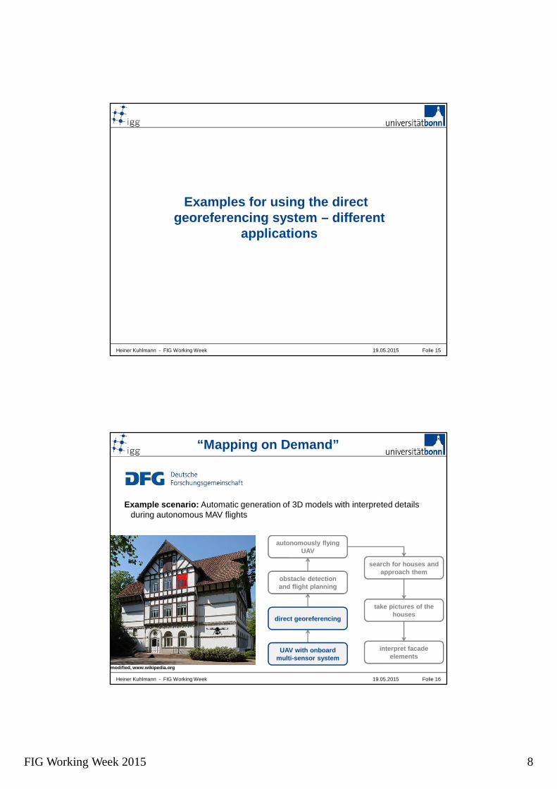
FIG Working Week 2015 8
Heiner Kuhlmann - FIG Working Week 19.05.2015 Folie 15
Examples for using the direct georeferencing system – different
applications
Heiner Kuhlmann - FIG Working Week
“Mapping on Demand”
19.05.2015 Folie 16
autonomously flying UAV
obstacle detection and flight planning
direct georeferencing
search for houses and approach them
take pictures of the houses
interpret facade elements
UAV with onboard multi-sensor system
modified, www.wikipedia.org
Example scenario: Automatic generation of 3D models with interpreted details during autonomous MAV flights

FIG Working Week 2015 9
Heiner Kuhlmann - FIG Working Week
“Mapping on Demand”
19.05.2015 Folie 17
Flight test:
• performance of 4 flights at one estate
• ~ 5 min per flight
• image acquisition (1 Hz)
• real-time direct georeferencing of the camera during the flights
• bundle adjustment of the images (3D point clouds as results)
• no use of ground control points
Evaluations:
• How well do the results (point clouds) of the different flights match each other?
• How is the absolute accuracy of the point clouds?
Heiner Kuhlmann - FIG Working Week
“Mapping on Demand”
19.05.2015 Folie 18
Point cloud resulting from four different flights (no registration!)

FIG Working Week 2015 10
Heiner Kuhlmann - FIG Working Week
“Mapping on Demand”
19.05.2015 Folie 19
distance in meter
Comparison to a TLS point cloud:
• differences between the georeferencedterrestrial laserscanner (TLS) point cloud and the georeferenced MAV point cloud
• average deviations: < 5 cm (nearest neighbor)
Current state:
• the georeferenced images are sent to a ground station during flights
• the bundle adjustment is estimated on a ground station (on the fly) in near-real-time
Heiner Kuhlmann - FIG Working Week
precision farming
19.05.2015 Folie 20
measurement of plant growth rates with directly georeferenced aerial images

FIG Working Week 2015 11
Heiner Kuhlmann - FIG Working Week
geomorphology
19.05.2015 Folie 21
Heiner Kuhlmann - FIG Working Week 19.05.2015 Folie 22
Other applications for the direct georeferencing system…

FIG Working Week 2015 12
Heiner Kuhlmann - FIG Working Week
portable laserscanning system
19.05.2015 Folie 23
magnetometer
GPS antenna
GPS antenna
laser scanner
directgeoreferencing system
directly georeferencedportable laserscanningsystem
measurement setup for the
system calibration
Heiner Kuhlmann - FIG Working Week
portable laserscanning system
19.05.2015 Folie 24
differences to a georeferenced TLS point cloud

FIG Working Week 2015 13
Heiner Kuhlmann - FIG Working Week 19.05.2015 Folie 25
Conclusion
direct georeferencing system– weight: < 400 g
– size: 11.0 x 10.2 x 4.5 cm
– accuracy: < 1-3 cm position, < 0.5 deg attitude
Heiner Kuhlmann - FIG Working Week 19.05.2015 Folie 26
Conclusion
• system is small and lightweight
• system provides georeferenced poses (3D position and 3D attitude) with a rate of 100 Hz in real-time !
• ambiguity resolution with in-house developed GPS algorithms within the first epoch possible => important under frequent signal interruptions
• yaw angle determination is based on a onboard multi-antenna GPS system (low-cost) and GPS/IMU integration
• system can be used in various applications
under ideal conditions

FIG Working Week 2015 14
Heiner Kuhlmann - FIG Working Week Folie 2719.05.2015
Thank you very much for your attention!