a coastal/ocean engineering graduate project: evaluation
TRANSCRIPT

Paper ID #9032
A Coastal/Ocean Engineering Graduate Project: Evaluation of HurricaneProtection Concept
Dr. Robert W. Whalin, Jackson State University
Robert W. Whalin, Ph.D., P.E. is Professor of Civil Engineering College of Science, Engineering, andTechnology, Jackson State University. He serves as Director, Coastal Hazards Center of Excellence,sponsored by the U.S. Department of Homeland Security. Dr. Whalin led the new School of Engineeringthrough a highly successful accreditation evaluation by the ABET. He oversaw completion of design, con-struction and occupation (in 2009) of a new 90,000,000 square foot Engineering Building. He is DirectorEmeritus of the Engineer Research and Development Center. Dr. Whalin completed 36 years of exemplarycivilian service in the Department of Army including 20 years in the Senior Executive Service as Director,Army Research Laboratory (ARL); Director, USACE* Waterways Experiment Station; and Technical Di-rector, USACE Coastal Engineering Research Center. The ARL program exceeded $1,100,000,000 andhad a 2,200 person workforce at six primary locations throughout the United States plus small groupsin Japan and the United Kingdom. Dr. Whalin was the recipient of the Distinguished Presidential RankAward, two Meritorious Presidential Rank Awards, Exceptional Civilian Service Award, three Meritori-ous Civilian Service Awards, two Department of Army Awards for Outstanding Achievement in EqualEmployment Opportunity and the Silver Order of the DeFleury Medal. A registered professional engi-neer, Dr. Whalin holds a BS degree in Physics from the University of Kentucky, a MS degree in Physicsfrom the University of Illinois and a PhD in Oceanography from Texas A & M University. Prior to hisservice with the U.S. Army Corps of Engineers, he worked six years in Southern California for Tetra TechInc., National Engineering Science Co., Interstate Electronics Corporation and Hughes Aircraft Co. Dr.Whalin is a renowned Coastal Engineer, widely recognized for pioneering experimental research of wavetransformations in convergene zones and for innovative coastal models of long waves and non-linear wavetransformations in harbors, bays, lagoons and estuaries. He has authored/co-authored over a hundred jour-nal, conference, or symposia publications and technical reports. *USACE is United States Army Corpsof Engineers
Mr. Thomas William Richardson, Coastal Hazards Center of Excellence
Mr. Richardson is Deputy Director of the Department of Homeland Security’s Coastal Hazards Centerof Excellence at Jackson State University. The Center is co-led by the University of North Carolina atChapel Hill.
Mr. Richardson is an engineering graduate of The Citadel, the University of Miami, and the InternationalInstitute for Hydraulic and Environmental Engineering in Delft, The Netherlands. His career has focusedon managing and performing applied research in coastal and hydraulic engineering. In 2009, he retiredas Director of the Coastal and Hydraulics Laboratory of the Engineer Research and Development Centerand began work at his current position.
Dr. Himangshu Shekhar Das, Jackson State University
Dr. Himangshu Das has 15 years experience in conducting coastal and oceanographic hydrodynamic,sediment transport and water quality studies, feasibility studies and design analysis. His modeling expe-rience includes surge modeling, sediment transport, coastal zone transport including inlet and surf zonedynamics, TMDL development, groundwater transport. He has conducted numerous hydrodynamic andmorphodynamic studies in river and tidally and wind dominated coastal regions along the Atlantic, Pacific,and Gulf coasts. This work has required expertise in physical oceanography, beach dynamics, coastal andestuary processes, sediment dynamics and water quality. he has also developed and applied hydrodynamicmodels for circulation, sediment transport, water quality studies, surf zone transport, inlet dynamics, andstorm surge analysis. Dr. Das has authored or coauthored more 20 technical publications on coastal andnear-shore processes and ocean engineering.
Mr. Donald L Hendon
c©American Society for Engineering Education, 2014
Page 24.25.1

Paper ID #9032
Mr. Donald L. Hendon, Mississippi Department of Transportation Mr. Hendon is an engineer in theBridge Division of the Mississippi Department of Transportation and a graduate student in the Departmentof Civil and Environmental Engineering at Jackson State University, JSU. Mr. Hendon is pursuing a MSEngineering degree under scholarship from the Coastal Hazards Center of Excellence at JSU sponsoredby the Office of University Programs, Department of Homeland Security.
c©American Society for Engineering Education, 2014
Page 24.25.2

A Coastal/Ocean Engineering Graduate Project: Evaluation of a Hurricane Protection Concept
Abstract
The Galveston Hurricane of 1900 was the most devastating hurricane to impact the United States coastal areas of the Gulf of Mexico with respect to loss of life (8,000-10,000). Half the Galveston buildings were destroyed as a 4.7m surge inundated the island. Island elevations were only 0.9-2.4m above sea level. The engineering feats comprising recovery of the island over the next six years were truly amazing. Every building standing was raised to an elevation of 5.2m above sea level by hydraulic fill. A concrete seawall was constructed to serve as a hurricane barrier (now approximately 16.2km long with six extensions) for the downtown Galveston area. Rapid growth of the Houston/Galveston metropolitan area and Hurricane Ike in 2008 have made the citizens, local governments, and industries acutely aware that a Category 5 severe hurricane surge perhaps six meters plus in elevation such as Katrina or Camille would most likely pose unacceptable threats to life and the rapidly expanding Houston economy. A hurricane protection concept called the Ike Dike has been thrust forward as a means of protecting Galveston Island and the greater Houston metropolitan area from a catastrophic hurricane surge, even more intense than Hurricane Ike or the 1900 Galveston Hurricane. This paper documents graduate student participation in this project. It also includes preliminary results from exploration of this concept with respect to reducing hurricane surge inundation from a catastrophic hurricane to an acceptable level. Results from this project will comprise input to an economic team who will evaluate the economic efficacy of the concept. The graduate student project formulated was for the students to gain experience in investigating surge levels with and without the conceptual project and, most importantly, to gain an appreciation of interdisciplinary teamwork involving both US and international (Netherlands) graduate students and professors. While working under the guidance from professors, four graduate students had key roles in various phases of this high end computational fluid dynamics (CFD) investigation and were key contributors to grid elevations, formulating impact data, analyzing computational output, preparing visuals of the results for project meeting and participating in meetings. Results from the systematic computational investigations of surge level reduction are highly encouraging.
Background
The background for this student project had its origins with the devastating Galveston Hurricane of 1900. At the time, Galveston Island was 0.8-4.8km wide and 45.1km long. The highest elevation was 2.7m, the population was 38,000, and Galveston was emerging as one of the most important cities in Texas. It was the third largest port in the nation and was second largest port of entry for European immigrants. On Sept. 8, 1900 this hurricane made landfall, with little
Page 24.25.3
warning, resulting in 8,000-10,000 deaths (20-25% of the total population). This was the most deadly natural disaster to strike the U.S. An amazing recovery ensued, based on recommendations of a board chaired by BG (ret) Henry Martyn Robert, former Chief of Engineers of the U.S. Army. Recommendations included the following:
(1). A 4.8km curved seawall constructed to +5.2m mean low tide.
(2). A hydraulic fill to 5.5m for a 61m distance behind the seawall.
(3). A brick pavement 10.7m back of the seawall, soil and bermuda grass for another 18.3m back.
The seawall was 5,362m long; 4.9m wide at the bottom, and 1.5m wide at the top. Large granite blocks were placed seaward for 8.7m to stabilize the toe. There were 500 city blocks of fill (12,462,000 cubic meters) and 2,100 buildings were lifted.
Construction was completed in 1904 (culminating with a big party); an absolutely astounding feat with the construction technology of over 100 years ago. The length of seawall has been extended six times since and it is now 16.2km long constructed to the same 5.2m elevation.
If complacency regarding the degree of hurricane protection afforded the area had set in during the ensuing 100 years, that has been overcome by Hurricane Katrina in 2005 that devastated New Orleans and the Mississippi Gulf Coast, Hurricane Rita, and most directly by Hurricane Ike (Sept. 2008) [1,2] which caused extensive damage (the third most costly hurricane in the United States) in the Galveston and greater Houston metropolitan area. There was ample warning for Hurricane Ike. More deaths occurred during the Hurricane Rita (landfall in Sabine, TX) evacuation than directly from the storm itself. Hurricane Ike had a central pressure of 935mb and maximum sustained winds of 230.1kph. The storm parameters for Hurricane Ike are practically identical to those estimated for the 1900 Galveston Hurricane (936mb, 230.1kph). For comparison, Hurricane Katrina (2005) had a central pressure of 902mb and maximum sustained winds of 271.4kph. Hurricane Camille (1969) had a central pressure of 905mb and maximum sustained winds of 305.8kph (Category 5). Hurricane Rita had a central pressure of 937 mb at landfall and maximum sustained winds of 193.1kph.
Hurricane Protection Concept Texas A&M University at Galveston (TAMUG) has been studying the effects of hurricane surge in Galveston, Galveston Bay and the greater Houston metropolitan area for several years. The Ike Dike Project is led by Dr. William J. Merrell, Professor and George P. Mitchell ’40 Chair, Department of Marine Sciences, TAMUG. Dr. Merrell credits engineers in the Netherlands with the Ike Dike concept [3, 4, 5, 6]. The concept is quite practical and elegant in its straight forward approach. The concept is to build on the proven effectiveness of the 16.2km long Galveston P
age 24.25.4

Seawall constructed to an elevation of 5.2m and extend this seawall many miles east and west to protect industries, properties and the entire greater Houston metropolitan area from disastrous hurricane surge effects. The east and west termini of the seawall are to be determined. The seawall can be incorporated into the coastal dune line and could have a highway on the top surface. The Houston Ship Channel and Bolivar Roads entrance to Galveston Bay would be spanned by a surge barrier allowing for the existing natural tidal flow of gulf waters into and out of the bay. A large gate in the middle of the surge barrier at Bolivar Roads would close only if a hurricane approached. Although the length of the Ike Dike is to be determined, it is envisioned to protect the coastal communities in Chambers and Brazoria Counties. An eminent team of partners was formed by TAMUG to carry the concept evaluation to the next level and to openly involve stakeholders in the effort. Partners and collaborators include engineers from The Netherlands, Delft Technical University, Texas A&M University, TAMUG, economics experts, planning experts, municipal, county and state governments, Army Corps of Engineers Galveston District, the Engineer Research and Development Center (ERDC) and the Jackson State University Coastal Hazards Center of Excellence (sponsored by the Department of Homeland Security).
This project involved participation of four graduate students in evaluation of a continuous seawall at an elevation of 5.2m with an eastern end near Sea Rim State Park and a western end beyond Freeport.
The concept evaluation is not an engineering design study, it is merely an investigation of the magnitude of surge reduction to be expected from a set of storms spanning the joint probability model (JPM) used to generate synthetic storms. Recent advances have been made by ERDC using Baysian quadrature. The revised methodology is termed joint probability method with optimal sampling using Baysian quadrature (JPM-OS-BQ). This will not be discussed further since ERDC is performing this task and it is unrelated to the graduate student project. The following sections describe preliminary results from four storms (with varying intensities) making a direct landfall in the Houston/Galveston area.
Concept Evaluation Strategy
Several basic principles were formulated during development of the strategy to evaluate the efficacyof the Ike Dike concept:
1. Use the most advanced and widely accepted CFD hurricane surge modeling system available.
2. Take advantage of previous results using this modeling system. 3. Verify the reasonableness of the modeling system by comparing with Hurricane Ike
measured data. Page 24.25.5
4. Use the selected modeling system to compute surges both for existing conditions and with the Ike Dike concept in place to ensure comparability of results.
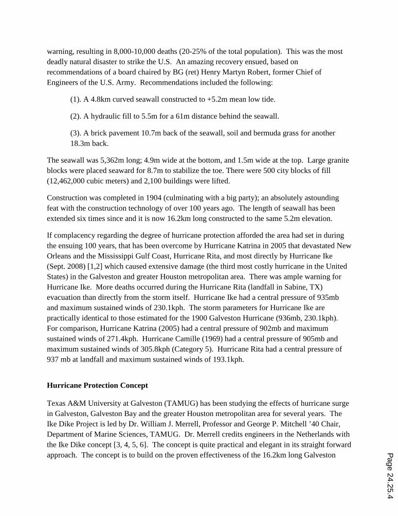
The modeling system selected, CSTORM (depicted in Figure 1), was furnished by ERDC. This system was developed for the many simulations used to help analyze, evaluate, and design hurricane protection for New Orleans after Hurricane Katrina. The cyclone wind model is MORPHOS-PBL, an advanced planetary boundary layer model. The regional wave model is WAM. The nearshore wave model (includes wind and pressure plus wave and surge) is STWAVE, which is dynamically coupled to the storm surge model ADCIRC.
Figure 1: Modeling System (provided by ERDC)
This effort used the most recent Federal Emergency Management Agency (FEMA) storm population and surge modeling grid for the area, with relatively minor shallow water grid modification to obtain a more refined resolution in the nearshore and Galveston Bay areas. Computational assets at the ERDC Supercomputer Center were used for the computations through an Education Partnership Agreement and a Cooperative Research and Development Agreement between Jackson State University and ERDC.
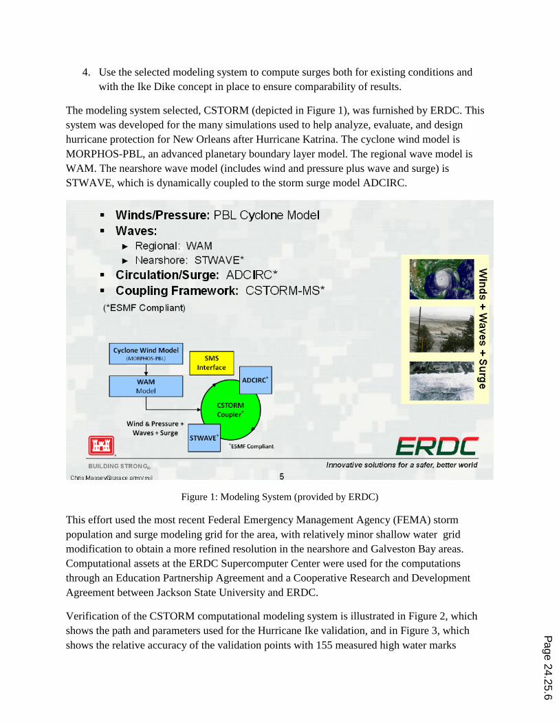
Verification of the CSTORM computational modeling system is illustrated in Figure 2, which shows the path and parameters used for the Hurricane Ike validation, and in Figure 3, which shows the relative accuracy of the validation points with 155 measured high water marks
Page 24.25.6

obtained by the United States Geological Survey (USGS) [7] from the Sabine River to Corpus Christi Bay. Most comparisons in the area were within + 0.5 meters, especially in the Galveston Island and greater Houston metropolitan area. The CSTORM modeling system and grid used were considered to be verified.
The next task was to compute results for both existing conditions and for the protection system. These computations are described in the following section.
Figure 2: Hurricane Ike Validation
Page 24.25.7
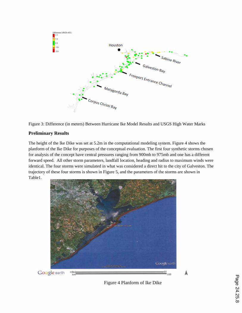
Figure 3: Difference (in meters) Between Hurricane Ike Model Results and USGS High Water Marks
Preliminary Results
The height of the Ike Dike was set at 5.2m in the computational modeling system. Figure 4 shows the planform of the Ike Dike for purposes of the conceptual evaluation. The first four synthetic storms chosen for analysis of the concept have central pressures ranging from 900mb to 975mb and one has a different forward speed. All other storm parameters, landfall location, heading and radius to maximum winds were identical. The four storms were simulated in what was considered a direct hit to the city of Galveston. The trajectory of these four storms is shown in Figure 5, and the parameters of the storms are shown in Table1.
Figure 4 Planform of Ike Dike
Page 24.25.8

Figure 5: Trajectory of storms with direct hit to Galveston, TX
Table 1: Parameters of Storms with Direct Hit to Galveston, TX
Storm Identification Landfall Headin
g CP Vf Rmax
Lat Long (deg) (mb) (knots) (nmi)
1.TEX_FEMA_RUN122.TROP 29.27 ‐94.84 ‐35 900 11 17.7
2.TEX_FEMA_RUN155.TROP 29.27 ‐94.84 ‐35 930 17 17.7
3.TEX_FEMA_RUN121.TROP 29.27 ‐94.84 ‐35 960 11 17.7
4.TEX_FEMA_RUN561.TROP 29.27 ‐94.84 ‐35 975 11 17.7
Utilizing two storms with the same trajectory but different central pressures, results of the Ike Dike concept are quite apparent. FEMA_RUN121, with a central pressure of 960mb, is the weaker of the two storms. Figure 6 shows surge levels for existing conditions as this storm passes. The simulation shows flooding of 3 to 4 meters over a wide area. The existing seawall appears to have little to no effect on surge elevations other than for the area of Galveston Island directly behind the seawall (which was not overtopped). Figure 7 shows the same storm with the Ike Dike in place. This simulation resulted in surge levels of less than a meter almost everywhere in Galveston Bay. Figure 8 shows the difference between the two conditions. This image shows
Page 24.25.9

that the upper portions of the bay experienced a decrease in water surface elevation of up to 4 meters with the Ike Dike concept in place.
Figure 6: Existing condition for simulation FEMA_RUN121
Figure 7: With project condition for simulation FEMA_RUN121 Page 24.25.10
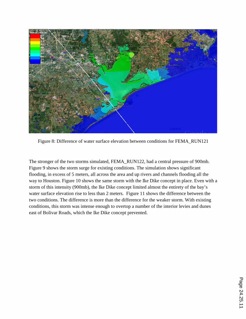
Figure 8: Difference of water surface elevation between conditions for FEMA_RUN121
The stronger of the two storms simulated, FEMA_RUN122, had a central pressure of 900mb. Figure 9 shows the storm surge for existing conditions. The simulation shows significant flooding, in excess of 5 meters, all across the area and up rivers and channels flooding all the way to Houston. Figure 10 shows the same storm with the Ike Dike concept in place. Even with a storm of this intensity (900mb), the Ike Dike concept limited almost the entirety of the bay’s water surface elevation rise to less than 2 meters. Figure 11 shows the difference between the two conditions. The difference is more than the difference for the weaker storm. With existing conditions, this storm was intense enough to overtop a number of the interior levies and dunes east of Bolivar Roads, which the Ike Dike concept prevented.
Page 24.25.11

Figure 9: Existing condition for simulation FEMA_RUN122
Figure 10: With project condition for simulation FEMA_RUN122
Page 24.25.12

Figure 11: Difference of water surface elevation between conditions for FEMA_RUN122
Remaining Work
Computational results from numerous other storms with varying intensity that make up the JPM-OS-BQ data set have been simulated and are currently under detailed evaluation by the graduate students (under direction of professors). A large effort over the next several months will be devoted to transferring wind and surge data in a GIS format to the economics team and others that TAMUG has assembled. Final report preparation will be extensive and includes transfer of 100% of the computed results to the TAMUG team. Assuming the efficacy of the Ike Dike concept is verified by the total study team and embraced by local, state and federal stakeholders, additional computational efforts will be needed to help quantify the barrier termini to the east and west, to investigate optimal heights to the extensions to the existing seawall and eventually to produce surge data to help quantify final design of the Ike Dike.
Results and Conclusions
The following conclusions were reached with respect to the graduate student’s performance on the project and with respect to the efficacy of the Ike Dike concept.
(1). The following graduate student results and conclusions were obtained.
(a). Valuable experience was gained working on a real world very high visibility engineering project (a rare opportunity at the M.S. level).
Page 24.25.13

(b). Students performed the following tasks:
• Set up input data for the CFD simulation. • Analyzed the CFD results (with professorial guidance). • Performed the comparison of Hurricane Ike simulation with USGS
high water marks. • Prepared visuals for major project meetings. • Participated in weekly project meetings. • Prepared parts of this paper.
(2). Students obtained an appreciation of the complexity of political, social, and economic stakeholder relationships and interactions in the early stages of trying to promote the efficacy of a regional project of this magnitude across city, county, and state political entities.
(3). Experiences gained by graduate students in collaborating with the TAMUG team members across disciplinary areas (engineering, oceanography, sociology, economics, urban planning and others), geographical areas (Mississippi, Texas, Europe) and from different nations (The Netherlands) was extremely rare at the M.S. level and is projected to profoundly influence their future careers in a positive manner.
(4). Preliminary results seem to indicate that the potential for the Ike Dike concept to protect Galveston Island, the greater Houston metropolitan area, and perhaps even larger areas appears to be unequivocal with respect to decreasing the hurricane surge to levels of minimal flooding concern.
(a). In the case of relatively small storms with a central pressure of about 960mb or above, it appears that surge elevations in Galveston Bay and the greater Houston metropolitan area would be limited to less than 2 meters by the Ike Dike concept.
(b). For very intense storms with a central pressure of 900mb (Hurricane Ike and the 1900 Galveston Hurricane had a central pressure of about 935mb), flooding for existing conditions was in excess of 5 meters over a very large area including rivers and channels throughout Houston. The Ike Dike concept reduced the water elevation rise by more than 3 meters over a large area. The entire Galveston Bay area elevation rise was reduced to less than two meters by the Ike Dike concept.
Page 24.25.14

Acknowledgements
The authors gratefully acknowledge Dr. William J. Merrill, TAMUG Ike Dike project Director, for embracing the Coastal Hazards Center of Excellence at Jackson State University as a partner in the Ike Dike project team and for providing funds for the effort reported herein. We acknowledge the key participations of Dr. Jeffrey Melby, Dr. Chris Massey and Dr. Norberto Nadal for their partnership and dedicated participation in the overall Ike Dike project. Dr. Jeffery Holland, Director of ERDC, Dr. Reed Mosher, Director of ERDC’s Information Technology Laboratory (ITL), and Dr. Robert Maier (ITL) are gratefully acknowledged for facilitating and providing access to the computational assets used in the study. The Science and Technology Directorate, Department of Homeland Security is acknowledged for (1) providing fellowship funding for three of the graduate students who participated in the project, and (2) providing funding for the Coastal Hazards Center of Excellence at Jackson State University. Graduate students are gratefully acknowledged for participation in this project: Fatima Diop, Nakarsha Bester and Chris Herron. Finally, the Coastal Hazards Center’s tireless Administrative Assistant, Ms. La Shon Lowe, is gratefully acknowledged for her assistance in preparation of this paper and for the many duties she performed as a part of this project.
References
[1] Knowledge Engineering. (2011). Hurricane Ike Impact Report. Retrieved from http://thestormresource.com/Resources/Documents/Full_Hurricane_Ike_Impact_Report.pdf
[2] Ruijs, M. (2011). The effects of the “Ike Dike’ barriers on Galveston Bay. Delft: M. Ruijus
[3] Merrell, W. (2010) The Ike Dike [PowerPoint Slides]. Retrieved from http://www.tamug.edu/ikedike/Presentations.html
[4] Merrell, W. The Ike Dike: A Coastal Barrier Protecting the Houston/Galveston Region from Hurricane Storm Surge (2010) [PowerPoint Slides]. Retrieved from http://www.tamug.edu/ikedike/Presentations.html
[5] Merrell, W. The Ike Dike: Corps of Engineers. (2012 February) [PowerPoint Slides]. Retrieved from http://www.tamug.edu/ikedike/Presentations.html
[6] Merrell, W. (2012, September 27) The Ike Dike: Board of Trustees, Galveston Wharves [PowerPoint Slides]. Retrieved from http://tamug.edu/ikedike/Presentations.html
[7] Jeffery W. East, Michael J. Turco, and Robert R. Mason, Jr., “Monitoring Island Storm Surge Flooding from Hurricane Ike in Texas and Louisiana, September 2008, U.S. Geological Survey, Open-File Report 2008-1365.
Page 24.25.15