a citizens’ wilderness proposal for pennsylvania’s ... · pennsylvania’s allegheny national...
TRANSCRIPT

A Citizens’ Wilderness Proposal forPennsylvania’s Allegheny National Forest
“We Americans are the people we are largely becausewe have had the influence of the wilderness on our lives.”
–Pennsylvania Representative John P. Saylor,on sponsoring the Wilderness Act in Congress, 1956
Friends of Allegheny Wilderness
2003

Acknowledgements
Our sincerest thanks to everyone who helped craft this proposal.The cumu-lative efforts of hundreds of people and years of advocacy on behalf of wilder-ness in Pennsylvania’s Allegheny National Forest is manifested in the pages ofthis report. From Wilderness Act of 1964 author Howard Zahniser’s humblebeginnings in the borough of Tionesta in the early 20th century, to thePennsylvania Sierra Club’s efforts to gain wilderness here during the 1970s andearly 1980s, to the current efforts of Friends of Allegheny Wilderness and oursupporters, the development of a wilderness vision for the Allegheny NationalForest has been a long time in the making.
This document has drawn significantly from previous proposals prepared bythe Sierra Club for the Hickory Creek (by Helen McGinnis),Tracy Ridge andAllegheny Front (both by Richard Pratt) areas of the Allegheny National Forest.Bryan Black, a Ph.D. candidate at the Penn State University School of ForestResources deserves great credit as he did the bulk of the GeographicInformation System work in finalizing our maps. His lab partner Steve Signellmade important contributions as well.
Many thanks also to: Chuck Benson, Mike Bleech, Michael Carroll, GinaEllis, Dina El-Mogazi, Melissa Fetterman, Jeremy Garncarz, Matt Getner, TedGrisez, Tarius Haggood, Joe Hardisky, Shannon Hughes, Fran Hunt, JohnImhof, Chad Johnson, Kirk Johnson, Gail Johnston, Mike Kaizar, Bart Koehler,Kevin Mack, Tim Mahoney, John McComb, Fred Mendenhall, BrianO’Donnell, Chuck Palasick, Bob Papp, Larry Romans, Tom Rooney, VirginiaRozic, Dave Saville, Doug Scott, Jim Solley, Dave Startzell, Scott Stoleson, BobStoudt, Susan Stout, David Sublette, Bruce Sundquist, Kristen Sykes, GerryThomas, Lori Walker, John Wallin,Tim Walter, Melyssa Watson, Paul Weigman,Peter Wray,Alice Zahniser, Ed Zahniser, and Matt Zahniser. If anyone has beenleft off this list, rest assured that your efforts have not gone unnoticed.
We would like to acknowledge all receptionists at the Allegheny NationalForest offices, and other Allegheny National Forest personnel for their kind helpin answering questions and with obtaining data, maps, and other importantinformation.The following Forest Service individuals have been of great help(this is by no means a complete list): Brenda Adams-Weyant, Mike Antalosky,Jim Apgar, Kevin Elliott, Eric Flood, Sylvia Grisez, Andrea Hille, LindaHouston, Chris Losi, Jack McLaughlin, Steve Miller, Brad Nelson, NadinePollack, Scott Reitz, Dan Salm,Wendell Wallace, John Weyant, Linda White.
Special thanks to: Acorn Foundation, American Wilderness Coalition,Campaign for America’s Wilderness, Fund for Wild Nature, HawksglenFoundation, Mytopo.com, Norcross Wildlife Foundation, Patagonia, Inc.,Peradam Foundation, Phoebe W. Haas Charitable Trust, Sierra Club,TortugaFoundation,The Wilderness Society and TWS’s Wilderness Support Center, andthe Wildlands Project. The Western Pennsylvania Conservancy contributedvaluable biological information to this proposal.
Cover photo of the Tionesta Research Natural Area old-growth forest by Kirk Johnson.
Copyright © Friends of Allegheny Wilderness, 2003, 2008.
Allegheny Valley ConservancyBackcountry Hunters and AnglersBartramian Audubon SocietyBrokenstraw Watershed CouncilButler Outdoor ClubCampaign for America's WildernessCitizens for Pennsylvania's FutureClearWater ConservancyEastern Native Tree SocietyErie Outing ClubEvergreen ConservancyExplorer's Club of PittsburghFinger Lakes Trail ConferenceFrench Creek Valley ConservancyFriends of Briar Bush Nature CenterHoward County, Maryland Bird ClubJuniata Valley Audubon SocietyKeystone Trails AssociationLake Erie Group Sierra ClubLake Erie-Allegheny Earth ForceLehigh Valley Audubon SocietyMoshannon Group Sierra ClubPenn State Eco ActionPennsylvania Chapter of the Sierra ClubPennsylvania Izaak Walton LeaguePennsylvania Native Plant SocietyPennsylvania Reps. for Environmental ProtectionPennsylvania Trout UnlimitedPine Creek Headwaters Protection GroupPine Creek Land Conservation TrustPocono Heritage Land TrustPrimalNature.orgRoger Tory Peterson InstituteSchuylkill Center for Environmental EducationSeneca Rocks Audubon SocietySusquehannock Trail ClubTiadaghton Audubon SocietyWest Virginia Highlands Conservancy
FFrriieennddss ooff AAlllleegghheennyy WWiillddeerrnneessss
222200 CCeenntteerr SSttrreeeett
WWaarrrreenn,, PPAA 1166336655
881144--772233--00662200
iinnffoo@@ppaawwiilldd..oorrgg
wwwwww..ppaawwiilldd..oorrgg

Table of Contents2 Foreword by Ed Zahniser5 Executive Summary6 Acronyms7 Introduction7 Wilderness and the Allegheny National Forest7 What is Wilderness and the Wilderness Act?8 Why an Allegheny National Forest Citizens’Wilderness Proposal?9 Timber Harvest
10 Climate10 Geology11 Flora and Fauna13 Human Activity14 Hunting and Fishing15 North Country National Scenic Trail16 Mineral Rights16 Conclusion18 Wilderness Selection Criteria19 Allegheny National Forest Wilderness and Recreational Potential20 Allegheny Front Wilderness – Proposed22 Chestnut Ridge Wilderness – Proposed24 Clarion River Wilderness – Proposed26 Cornplanter Wilderness – Proposed28 Hickory Creek Wilderness addition – Proposed30 Morrison Run Wilderness – Proposed32 Tionesta Wilderness – Proposed36 Tracy Ridge Wilderness – Proposed39 National Recreation Areas40 Allegheny National Recreation Area addition – Proposed42 Hearts Content National Recreation Area – Proposed44 Minister Valley National Recreation Area – Proposed46 Tanbark National Recreation Area – Proposed47 Sources49 Appendices
This beaver dam provides important wetland habitat along North Branch
Sugar Run in the proposed Chestnut Ridge Wilderness Area.
Photo by Kirk Johnson

2 • A Citizens’ Wilderness Proposal for Pennsylvania’s Allegheny National Forest
We Need More Allegheny Wilderness“For the permanent good of the whole people”
Long after my father Howard Zahniser hadmoved away from his boyhood home inTionesta, Pa., and settled in Washington,D.C.,Tionesta and the Allegheny area wereoften on his mind. Zahnie, as he wasknown, submitted an essay to Scribner’s mag-azine in the 1930s that was a nostalgic paeanto his coming-of-age years in Tionesta. It isalso emblematic that he and my motherAlice Zahniser chose as their last pre-par-enthood adventure a June 1937 canoe tripdown the Allegheny River from Olean,N.Y. to Tionesta. Also,my father was unableto part with the family home up on BridgeStreet in Tionesta even after his mother’sdeath in the 1950s. His lifelong close con-nections to the Allegheny watershed makethe prospect of now designating a reason-able amount of wilderness on the AlleghenyNational Forest so fitting.
On the 1937 canoe trip Zahnie was packing Henry David Thoreau’s first book A Week onthe Concord and Merrimac Rivers and a book of Ralph Waldo Emerson’s essays.“If you go to thewoods,” Emerson warned,“you must feed the mosquitoes.” Toting a Thoreau tome was to bea lifetime habit.Right up through his wilderness bill years of 1956 to 1964, Zahnie usually car-ried one from his sizable collection of Thoreauviana in the suit coats into which he had hadoversized inside pockets fitted to carry also Wilderness Society membership literature andwilderness bill propaganda. His coats were fabric file cabinets for the wilderness cause, and,from the get-go on his arrival at the Wilderness Society in 1945, he was its full-time advocate.
It was Thoreau who ground-truthed Emerson’s Transcendentalist valuation of nature, and, in1850 or 1851, in one of the two lectures that became the essay “Walking,” Thoreau penned thekoan-like assertion that “…in Wildness is the preservation of the World.” As a culture we havenot yet achieved enlightenment by contemplating Thoreau’s koan, but Thoreau himself saidthat the word World there is the Greek word Kosmos, meaning not only world but also beauty(hence cosmetics), pattern, and order. And Thoreau does not say that we ultimately preservewildness but that wildness preserves us.
If Zahnie’s work was necessary to the eventual fruition of the Wilderness Act —DavidBrower eulogized him as its “Constant Advocate”—then it may be to the birds of the Alleghe-nies that we owe that magnificent piece of public lands law and this fine new proposal, care-fully crafted by Friends of Allegheny Wilderness,The Wilderness Society and the Lake ErieGroup of the Sierra Club, for designating more wilderness on the Allegheny National Forest.What stands out in Zahnie’s 1937 canoe trip journal is his keen interest in and observation ofbirds. Entry after entry expresses his and my mother’s intense delight at the herons, warblers,vireos, phoebes, and others they encountered.These wilderness proposals, such as for ChestnutRidge and the Hickory Creek Wilderness Addition, would help address the severe problem offorest fragmentation that now threatens the future of neotropical songbirds and other species.
Zahnie’s love for birds propelled him toward his 15-year career with the U.S.Bureau of Bio-logical Survey and U.S. Fish and Wildlife Service from 1930 to 1945. There he met the men-
Howard Zahniser canoeing on the Allegheny River, June 1937.
Photo by Alice Zahniser
foreword

Friends of Allegheny Wilderness • 3
tors—self-taught naturalist Edward A. Preble, biologist Olaus J. Murie, mammalogist Ira N.Gabrielson, regional planner Benton MacKaye, and others—whose circle drew concern forbirds and other wildlife and their habitat into an even broader concern for preserving wilder-ness and wildness. The year before their Allegheny River trip, Zahnie had met in the Nation’sCapital with wilderness champion Robert Marshall and others to organize “the Washingtonsection of the Wilderness Society,” of which Zahnie was a charter member.
What but the world itself can be the meaning of the concept of ecosystem in a world inwhich Arctic terns migrate 20,000 miles yearly and birds from all seven continents congregateyearly in northwestern Alaska? It was ecologist Aldo Leopold, another close student of theThoreau canon and a founder of the Wilderness Society, who made continental leaps in wildthinking in one intellectual lifetime. Leopold took our concern for the natural world fromearly theorizing of “game management” based on extrapolating techniques of animal hus-bandry to articulating a land ethic—that we should treat the land (the entire biota) ethically,as community not commodity.
A major ethical thrust of the Wilderness Act is that we should make room for permanenceas well as for change:“…in Wildness is the preservation of the World,” beauty, pattern, order.One of the great meanings of wilderness for modern humans, Zahnie wrote in “The Need forWilderness Areas,” is that the experience of wilderness can show us our dependence and inter-dependence as well as our independence.We truly prosper, Zahnie believed, only when thewhole community of life on Earth prospers.The proposed Tionesta Wilderness seems partic-ularly compelling as protection for the Tionesta Scenic and Research Natural Areas.Two yearsago, while walking in the open and towering forest of the Research Natural Area, I tried toimagine how important a regional, natural shrine this forest may well be in another hundredyears—if given the adequate protection this wildernessproposal would afford.
It is likewise fitting that this wilderness proposal con-cerns the eastern United States, for that is “WhereWilderness Preservation Began,” as Zahnie titled a 1957speech about New York State’s “forever wild” ForestPreserve lands of the Adirondack and Catskill stateparks. For, from the 1870s into the 1890s, New Yorkerswere able to secure on their state-owned public landswhat the nation first attempted on our federal publiclands with the Forest Reserve movement championedby John Muir, Robert Underwood Johnson, and others.Today New York has 17 designated state wildernessareas defined by language nearly identical to that of thefederal Wilderness Act.
Certainly Pennsylvanians of this and future genera-tions also deserve the enduring benefits of close proxim-ity to such a common wealth of the wildness thatwilderness designation means to protect in perpetuity. Isit not the genius of democracy, properly understood,that the rights of future generations should be seen tooutweigh—for we live in hope that their numbers mayexceed our own—the rights of the present generations?It is part of the ethical thrust of the Wilderness Act notonly to recognize but to enfranchise those rights andthat hope.
This citizens’ proposal for designating a reasonableamount of wilderness on the Allegheny National Forestwill make room for permanence here while leavingample room for change. It recognizes our biotic com-
Ed Zahniser speaking at the August 2001 Pennsylvania
Historical and Museum Commission Marker dedication
ceremony for his father Howard Zahniser near Tionesta.
Photo by John McComb

4 • A Citizens’ Wilderness Proposal for Pennsylvania’s Allegheny National Forest
munity as wilderness while leaving ample forest resources available for commodity uses. It willgive future generations the opportunity—on these public lands owned in common by allAmericans—to experience wilderness and wildness while still enjoying the fruits of our mod-ern civilization, which certainly depends on quantities of natural resource commodities. Assuch, this carefully wrought wilderness proposal is both bold and modest, as befits the charac-ter of Howard Zahniser and his love for the Allegheny region and its people. For it was Zah-nie’s twin loves for people and the wild that saw him through a laborious eight-yearadvocacy—including tireless consultations with agencies and members of Congress, 18 publichearings, and 66 rewrites—for a National Wilderness Preservation System “for the permanentgood of the whole people.”
—Ed Zahniser
North Branch Sugar Run in the proposed Chestnut Ridge Wilderness Area.
Photo by Kirk Johnson

Friends of Allegheny Wilderness • 5
executive summaryIn delivering the keynote speech at the Denver ‘Wilderness 2000’ conference in September of2000, then Forest Service Chief Michael Dombeck stated that “Approximately five percent ofthe United States landbase is designated wilderness.That may not sound like much and in factit is not nearly enough. In revising our Forest Plans we must deliberately look for areas suitablefor inclusion in the Wilderness system.” Friends of Allegheny Wilderness (FAW) has takenChief Dombeck’s admonition to heart as the Allegheny National Forest (ANF) undertakesrevision of its 1986 Land and Resource Management Plan (Forest Plan).
Currently there are just two ANF areas designated as wilderness under the 1964 WildernessAct—the Hickory Creek and Allegheny Islands Wilderness Areas—together encompassingapproximately 9,000 acres, or less than two percent of the 513,000-acre Forest.This comparesto 18 percent of Forest Service land designated as wilderness nationwide, and 11 percent in theForest Service’s Eastern Region, of which the ANF is a part.This Citizens’Wilderness Proposalfor Pennsylvania’s Allegheny National Forest identifies a total of 54,460 acres of public land ineight different tracts within the proclamation boundary of the ANF that we believe qualify forinclusion in America’s National Wilderness Preservation System.We have also identified threeadditional parcels totaling 14,477 acres that could be designated as national recreation areas.Together, these proposed designations include public lands within Elk, Forest, McKean, andWarren Counties. In some cases our proposal corresponds to past inventory work of the Penn-sylvania Sierra Club or the Forest Service’s own roadless analyses. In other cases, it includespublic lands which have wilderness qualities but have previously been overlooked.
The ANF, Pennsylvania’s only national forest, is located in the densely populated easternUnited States and is within a day’s drive of half of the country’s population. Large urban cen-ters such as Buffalo, Cleveland, Detroit, Philadelphia, Pittsburgh,Washington, D.C. and othersare all within easy reach for those seeking a weekend wilderness retreat.While the easternUnited States holds about 60 percent of the nation’s population, it contains only about fourpercent of the National Wilderness Preservation System.The 1986 ANF Forest Plan identifiesthis acute wilderness shortage, stating: “It seems obvious that the demand for wilderness des-ignation on the Forest is high, and the available supply in the regional area is low.” Further, the1975 Eastern Wilderness Areas Act recognized that “In the more populous eastern half of theUnited States there is an urgent need to identify, study, designate, and preserve areas for addi-tion to the National Wilderness Preservation System.” Although more than 30,000 acres ofANF wilderness was originally proposed in this legislation, none was included in the final ver-sion of the bill.While we recognize the importance of continued ANF timber production tothe regional economy, it is vital at this juncture to complete the mandate sought by Congressmore than a quarter century ago with the Eastern Wilderness Areas Act here on the ANF. Ourgoal is not to impede or reduce timber production or other multiple uses of the Forest, butsimply to permanently protect the remaining wild areas here for the benefit of current andfuture generations of Americans.
Although a great deal of planning has gone into the forging of this proposal, it cannot besaid that it is a perfect document; nor should our proposed wilderness and national recreationarea boundaries necessarily be viewed as static. Our proposal is based on the most currentinformation that we have been able to gather through extensive field inventory, from Geo-graphic Information Systems data, from information provided by the Forest Service and otherorganizations, through interviews with various agency personnel, through hours of discussionwith key stakeholders and experts, and as the result of much internal debate with regard towhich ANF lands should be included in our final proposal. We welcome dialogue on this doc-ument and realize that the process for any public lands legislation requires the constructiveexchange of information, and communication amongst the stakeholders involved.Please directyour comments to:
Friends of Allegheny Wilderness, 220 Center Street, Warren, PA 16365(814) 723-0620 [email protected] www.pawild.org

6 • A Citizens’ Wilderness Proposal for Pennsylvania’s Allegheny National Forest
common acronyms usedin this document
ANF Allegheny National ForestAT Appalachian National Scenic TrailATC Appalachian Trail ConservancyATV All-terrain vehicleBP Before PresentDCNR Pennsylvania Department of Conservation and Natural ResourcesDEP Pennsylvania Department of Environmental ProtectionEPA Environmental Protection AgencyESA Endangered Species ActEWAA Eastern Wilderness Areas ActFAW Friends of Allegheny WildernessGMNF Green Mountain National ForestHNF Hiawatha National ForestNCT North Country National Scenic TrailNCTA North Country Trail AssociationNPS National Park ServiceNRA National Recreation AreaNWPS National Wilderness Preservation SystemPGC Pennsylvania Game CommissionPNDI Pennsylvania Natural Diversity InventoryRNA Research Natural Area

“Here is an American wilderness vision: the vision of ‘a wilder-ness-forever future.’ This is not my phrase, it is Howard Zah-niser’s. And it is not my vision, but the one that I inherited, andthat you, too, have inherited, from the wilderness leaders whowent before.”
–Douglas W. Scott, Campaign for America’s Wilderness
wilderness and theallegheny national forestFriends of Allegheny Wilderness (FAW), formed in2001, seeks to foster an appreciation of wilderness val-ues and benefits, and to work with local communities toensure that increased wilderness protection is a priorityof the stewardship of the Allegheny National Forest(ANF).This report presents the results of FAW’s exten-sive wilderness inventory process through whichnumerous individuals studied the wilderness potentialin the ANF. The wild lands presented in this reportmeet the requirements and intent of wilderness as out-lined in the 1964 Wilderness Act and encompass thewonderful landscape diversity and beauty of northwestPennsylvania’s Allegheny Plateau. As the population ofthe northeastern United States continues to increase, thevalue of these few remaining wild areas and the need toprotect them increases in concert. The pure, naturalattributes of these areas contribute to the high quality oflife many Pennsylvanians currently enjoy. Just as impor-tantly, these areas encompass the amazing biodiversityfound in Pennsylvania’s spectacular public lands.
The ANF is located on the Allegheny Plateau innorthwest Pennsylvania in four counties: Elk, Forest,McKean and Warren. Before the arrival of Europeansettlers, the Allegheny Plateau was sparsely populatedand heavily wooded. Forests dominated by old-growtheastern hemlock (Tsuga canadensis), American beech(Fagus grandifolia), eastern white pine (Pinus strobus),American chestnut (Castenea dentata), birch (Betulaspp.), and others covered nearly the entire land surfaceof the Plateau (Lutz 1930a,Whitney 1990).With theadvent of the logging railroad, the Allegheny Plateauwas unsustainably logged from approximately 1890-1920, during a period the Forest Service calls “thehighest degree of forest utilization that the world hasever seen in any commercial lumbering era” (Marquis1975). In the aftermath of this cutting the ANF wasestablished in 1923 with the first land purchases madeby the Forest Service under the authority of the 1911
Weeks Act to promote the reforestation and protectionof the Allegheny River watershed (Bishop 1925, Hen-retta 1929).
Pennsylvania’s only national forest, the Allegheny, is asignificant but often overlooked natural area. Today,despite its origin in forest and watershed protection, theANF has a disproportionately small amount of landdevoted to the National Wilderness Preservation Sys-tem (NWPS) when compared with national forest landin other states (U.S. Forest Service 2002).This is trueeven when the comparison is made to eastern stateswhere wilderness designation is meager (Klyza 2001).Less than 2% of the ANF is designated as wildernessunder the 1964 Wilderness Act, at Hickory Creek andAllegheny Islands.The mean for national forest landdesignated as wilderness nationally is 18% and in theForest Service’s Eastern Region, of which the ANF is apart, the figure is 11%.
what is wilderness and thewilderness act ?
The Wilderness Act of 1964 (Appendix A) createdAmerica’s National Wilderness Preservation System andgave Congress the authority to designate tracts of pub-lic land as wilderness areas, “for preservation and pro-tection in their natural condition.” The Wilderness Actstates that these lands “shall be administered for the useand enjoyment of the American people in such manneras will leave them unimpaired for future use and enjoy-ment as wilderness.”
The Wilderness Act defines wilderness by stating that“A wilderness, in contrast with those areas where manand his own works dominate the landscape, is hereby
Friends of Allegheny Wilderness • 7
introduction
Lumberjacks overseeing the payload of a turn of the 20th century
logging railroad in McKean County.
Taken from Taber (1974)

recognized as an area where the earth and its commu-nity of life are untrammeled by man, where man him-self is a visitor who does not remain.”
Wilderness areas are designated by Congress on fourof America’s public lands systems—land that is alreadyset aside as National Forests, National Parks, NationalWildlife Refuges (U.S. Fish & Wildlife Service), andlands managed by the Bureau of Land Management.Wilderness areas, like other federal public lands, belongto all Americans. Wilderness is important because itprovides undisturbed habitat for native flora and fauna,outdoor recreation opportunities, vital reference areasfor scientists, and economic benefits including help indiversifying local and regional economies.
Hunting, fishing, horseback riding, hiking, camping,bird watching, photography, and other forms of non-motorized recreation are all activities that are allowed infederal wilderness areas.The Wilderness Act prohibitssuch activities as logging, mining, road building, oil andgas development, and the use of motorized or mecha-nized equipment (except under emergency circum-stances). Mining or oil extraction may occur in awilderness area if valid mining claims or oil leases are inplace before an area is designated as wilderness.
Currently there are 704 individual units of theNWPS totaling more than 107 million acres, orapproximately 5% of the land base of the United States.One may easily peruse the NWPS, individual units ofthe system and legislation that established each unit ofthe NWPS on the Wilderness Net website —www.wilderness.net.
Pennsylvania has unique connections to the historyof the establishment of our NWPS. Former Pennsylva-nia Representative John P. Saylor, a Republican fromJohnstown, was the original sponsor of the Wilderness
Act in the U.S. House of Representatives. Upon intro-duction of the Wilderness Act in Congress, Saylorstated, “We Americans are the people we are largelybecause we have had the influence of the wilderness onour lives.” The author of the Wilderness Act itself andexecutive director of The Wilderness Society from1945–1964—Howard Zahniser—also hailed fromPennsylvania and had a special connection to theAllegheny region. Born in Franklin, Pa. in 1906, Zah-niser grew up and is now buried in Tionesta, a townthat lies on the southwest corner of the ANF. In 1956he drafted the first wilderness legislation and shep-herded it though numerous revisions and 18 hearings inCongress before it finally passed into law as the Wilder-ness Act on September 3, 1964. He was a tireless advo-cate to the end.
why an allegheny nationalforest citizens’ wildernessproposal?
In 1974 there was an opportunity for at least 30,000acres of ANF wilderness to be designated under theEastern Wilderness Areas Act (EWAA), legislationwhich recognized that “In the more populous easternhalf of the United States there is an urgent need to iden-tify, study, designate, and preserve areas for addition tothe National Wilderness Preservation System.” TheEWAA established 16 new federal wilderness areas in 12eastern states and 14 national forests, totaling 206,988acres in all. Pennsylvania’s two Senators at that time,Republicans Hugh Scott and Richard Schweiker,strongly supported the ANF designations (Appendix C).
8 • A Citizens’ Wilderness Proposal for Pennsylvania’s Allegheny National Forest
President Lyndon Johnson signing the Wilderness Act into law –
which Tionesta native Howard Zahniser originally authored – and
handing the pen to Zahniser’s widow, Alice. September 3, 1964.
Photo courtesy of Alice Zahniser
Howard Zahniser marker dedicated August, 2001 near Tionesta.
Photo by Carole Wray

Senator Schweiker stated on the Senate Floor on May31, 1974 that the EWAA would:
...help preserve for the millions of people in the eastern region ofour country, now and in the future, unspoiled natural areas to beenjoyed in their original state. It is important that we act now topreserve these unique areas, many of which are located withineasy access of our most heavily populated areas.
During the same debate Senator Scott stated that:
...after a year and a half of intense study by two Senate commit-tees, I am pleased that the so-called Eastern Wilderenss Areas Actof 1974 is now before us. I have taken an active interest in thedevelopment of this vital bill, especially as it concerns theAllegheny National Forest…Mr. President, I am proud to haveplayed a role in developing this bill. I hope the Senate willapprove it and pave the way for swift action in the House of Rep-resentatives.
Despite the support of Senators Scott and Schweiker,wilderness for the ANF was not included in the finalversion of the EWAA due to action in the U.S. Houseof Representatives.The late Congressman Albert John-son, whose district encompassed the Forest, asserted atthe time that there was no need for the wilderness des-ignations, stating, “If you fly from Bradford airport toHarrisburg as I do, you’ll realize Pennsylvania is nothingbut wilderness” (Hayes 1974).
In 1984 local Congressman Bill Clinger did supportan ANF wilderness bill that designated the HickoryCreek and Allegheny Islands Wilderness Areas (as well asthe Allegheny National Recreation Area)(Appendix B),but the acute wilderness shortage here remains andshould be rectified now. The 1986 Allegheny NationalForest Land and Resource Management Plan (ForestPlan), the 15-year document that guides managementstrategies for the entire ANF, formally identifies thisneed for change in Chapter 2, page 5, where it states:
It must be concluded that the demand for wilderness experienceon the ANF is very high, given that half the country’s popula-tion lies within a day’s drive of the Forest… It seems obviousthat the demand for wilderness designation on the Forest is high,and the available supply in the regional area is low.
Fortuitously, the areas Senators Scott and Schweikeradvocated for wilderness designation still exist as wild,undeveloped, unroaded areas that we believe could eas-ily make the transition, along with the other areas of theForest we have inventoried and included in this report,into the NWPS for the permanent good of the wholepeople.
ANF personnel are currently revising their ForestPlan as required by the 1976 National Forest Manage-ment Act.The current Forest Plan, completed in 1986,
provides the framework by which the ANF is managedfor a range of uses such as wildlife habitat, timber har-vesting, recreation, wilderness and others.The docu-ment you hold in your hands is meant to furtherdiscussion and understanding of one aspect of the For-est Plan revision: protection of new wilderness areasunder the Wilderness Act. As part of the Forest Planrevision, the Forest Service is required to reevaluate thewilderness potential on the ANF, and has the ability torecommend new wilderness to Congress.
timber harvest & multiple useEfforts to designate additional wilderness in the ANFshould not be viewed as a referendum on the legiti-macy of timber harvesting or oil and gas developmentin the Forest.We support the traditional range of uses ofthe ANF including timbering and drilling for oil andgas which are important components of the local econ-omy. These uses were, after all, part of the original rea-son President Calvin Coolidge established the ANF in1923 (Bishop 1925). However, we believe that there is aclear need to protect new federal wilderness in the For-est, in areas where timbering is not a significant activity,to complete the mandate here for eastern nationalforests established in the EWAA, and to balance therange of uses in the multiple-use philosophy so that theANF truly is used—as former Pennsylvania Governorand the first Forest Service Chief Gifford Pinchotintended—for the greatest good for the greatest num-ber over the longest period of time.
This also includes the use of recreational all-terrainvehicles (ATVs) and snowmobiles.There are designatedtrails in the ANF for the use of these vehicles, and wesupport this continued use.This wilderness proposaldoes not seek to close or restrict access to any of thedesignated ATV and snowmobile trails on the ANF.
Also, the ANF maintains a series of small wildlifeopenings across the Forest meant to act as a continualrepresentation of early-successional habitat for wildlifespecies that benefit from such habitat such as deer,turkey, Ruffed Grouse (Bonasa umbellus), and others.Plantings of shrubs and apple trees are often located inthese maintained openings. FAW fully supports thecontinuation of this program of maintained wildlifeopenings across the Forest. However, there are caseswhere formally maintained openings are found withinour proposed wilderness areas. For example, six open-ings totaling 38 acres are maintained within the pro-posed Chestnut Ridge Wilderness.We recommend thatthe relatively few maintained openings located in newlydesignated wilderness be permitted to revert naturallyto forest cover.
Friends of Allegheny Wilderness • 9

climate
Average high temperatures in the ANF region rangeapproximately from 30°F in January and December to80°F in mid-July. Average low temperatures for theregion range approximately from 10°F in February to60°F in mid-July. The frost free growing season on thePlateau lasts from 100 to 130 days (Whitney 1990).Because the ANF lies in the path of many storms thatcross the country from west to east, sudden weatherchanges occur throughout the year. The Forest is rakedeach summer by strong thunderstorms, and occasionallyeven tornadoes,which can churn their way through theForest, snapping large trees like toothpicks (Mohlen-brock 1986).The average annual precipitation for theForest is comparable to that for the state as a whole.Long term records show 41" at Ridgway in the south-east, 43" at Warren and Tionesta on the AlleghenyRiver, and 45" at Kane. The average yearly snowfallranges from 60" in the southern portion of the Forestto 100" closer to the Allegheny Reservoir.The com-bined effects of latitude, generally high elevation, andradiation conditions make the ANF area one of thecoldest in the Commonwealth (Sundquist et al., 1999).
geologyThe ANF region can be described as an elevated,mature, dissected plateau. The Allegheny Plateau ismade up largely of horizontally layered sedimentarysandstone and shale, with minimal faults or folds.Theseunderlying strata are protected by a forest cover anddeep soil developed through a relatively wet climate.On top of the plateau, the bedrock types are of thePennsylvanian Period, originating 280 to 310 millionyears BP. Stream valleys cut down into formations fromthe older Mississippian Period.These are underlain byDevonian Period rocks (350 to 400 million years BP).The high top of the Plateau in the area between Kaneand Marienville is often referred to as the ‘Big Level’because much of it lies above 2,000' in elevation withno dominant peaks (Schiner and Kimmel 1972,Sundquist et al. 1990, Ross 1996). During advances ofthe Wisconsin Laurentide glacier 10,000–20,000 yearsBP, the Plateau deflected the encroaching ice sheet tothe east and to the west, roughly where the AlleghenyRiver makes a large ‘ox bow’ into present day New YorkState (Hough 1936,Whitney 1990). Elevation withinthe proclamation boundary of the ANF ranges fromapproximately 1,100' to 2,300' (Sundquist, et al. 1990).
The surface of the Allegheny Plateau is very hillywith numerous short ridges and spurs that have no reg-ular orientation.Most ridges are broad and level on top.
The main valleys are deep and narrow, bounded bysteep walls.The massive sandstones and conglomeratesof the Pennsylvanian Period cap the hills of the region.Large exposed outcrops near the hilltops as the region’smany streams cut toward the Allegheny River are oneof the striking features of the ANF. These outcroppingshave played a significant role in human history on thePlateau by acting as rock shelters for indigenous people,as well as by providing important microhabitats fornative Allegheny Plateau flora and fauna.
The geological make-up of this region ensured thatpetroleum and natural gas would develop in sedimen-tary sandstone formations from the Upper Devonianperiod of the Paleozoic Era.These reservoirs lie gener-ally along a northeast-southwest orientation, typicallylonger than they are wide. It is believed that these for-mations were once the lagoons and sand bars of a shal-low sea that previously occupied the Appalachian Basin.As deposits covered the lagoons and sand bars over mil-lions of years, the sand bars formed sandstone and thebenthic lagoon mud formed shale, confining organicdeposits in the sandstone. Over time, these depositsconverted to pockets of petroleum, natural gas andsaline water through a process known as a stratigraphictrap (Allaby 1994, Ross 1996).This geological process,which took hundreds of millions of years, has played asignificant role in just the last 150 years of history in theANF region.The world’s first commercial oil well wasdrilled near Titusville, Pa. in 1859, 10 miles west oftoday’s ANF. As the industrial revolution took hold,petroleum became an indispensable product. Between1871 and 1987, more than 675 million barrels of oilwere removed from the Bradford oil field in McKeanCounty, Pa. and Cattaraugus County, N.Y. It is esti-mated that at least half of the oil deposits in this region
10 • A Citizens’ Wilderness Proposal for Pennsylvania’s Allegheny National Forest
The mature dissected landscape of the Allegheny Plateau in the
Allegheny National Forest.

have been used in a span of less than 150 years.TheBradford Era daily newspaper still proclaims the city ofBradford to be “The High Grade Oil Metropolis of theWorld.”
flora and faunaThe two most common tree species in historicAllegheny Plateau forests were the eastern hemlock andthe American beech, shade tolerant climax specieswhich together made up approximately 60% of all treesfound here (Lutz 1930a, Whitney 1990). Other com-mon species included: eastern white pine, Americanchestnut, sugar maple, red maple, black birch, yellowbirch, tulip poplar (Liriodendron tulipifera), and severaloak and hickory species. Flowers present include theJack-in-the-pulpit (Arisaema astrorubens), Solomon’s seal(Polygonatum pubescens), goldthread (Coptis groenlandri-can), purple trillium (Trillium erectum), yellow loostrife(Lysimachis quadrifolia),and sundrops (Oenothera pratensis).
Historically, the old-growth forest of the AlleghenyPlateau was characterized by white-tailed deer(Odocoileus virginianus) populations that were regulatedby natural processes—particularly predation by largecarnivores such as wolves (Canis lupus) and the NorthAmerican cougar (Puma concolor couguar)—to as few as10 deer per square mile.As a result, understory vegeta-tion was thick with high diversity. Deer were all butextirpated by 1900 due to unrestricted hunting prac-tices to meet demand for venison in large cities and log-ging camps (deCalesta 1994).Wolves and cougar werevirtually eliminated by this time through deliberateextermination programs. Like many eastern colonies,Pennsylvania offered bounties for destroying wolvesalmost from the time of first settlement (McIntyre1995).
The Pennsylvania Game Commission (PGC) beganreintroducing deer in Pennsylvania from other regionswith larger populations in the first decade of the 20thcentury. From 1907 until approximately 1940, the deerpopulation in the ANF climbed steadily to a peak ofnearly 44 deer per square mile, with the aid of newgame laws, a lack of predators, and abundant availablebrowse in the brushy recovering forests of the Plateau(Whitney 1990, deCalesta 1994).The deer populationdeclined somewhat from that peak, but has remainedhigher than historical levels (Rooney and Dress 1997).The heavy browsing pressure by this increased popula-tion over approximately 70 years has resulted in thereduced abundance of understory shrubs, and theirreplacement by ferns and grasses (deCalesta 1994).Thepresent day hunting community will likely play animportant role, along with the inevitable process of
natural succession, in moving new ANF wildernesstoward old-growth conditions by helping to controldeer populations within those wilderness areas.
The term ‘old-growth’ is used in this document todescribe a mature forest with a high degree of natural-ness operating at a climax state of natural succession—in essence uninfluenced by human activities. Such aforest possesses, among other characteristics, large livingtrees, large standing dead trees (‘snags’), a multi-layeredcanopy, a high degree of biological diversity, and anabundance of random downed large woody debris.His-torically, the vast majority of forested area on theAllegheny Plateau could accurately have been termedold-growth. There are a few remnant areas of foresttoday on the Plateau that can be termed old-growth, aswell as second-growth areas that are approaching thatthreshold.
Although most of the Allegheny Plateau forest wasold-growth in character, isolated natural disturbancessuch as windthrow were not uncommon, so that smallrecolonizing stands of various ages and species mixtureswere ubiquitous throughout the Plateau. Native Amer-icans of this region also created forest disturbances in
Friends of Allegheny Wilderness • 11
Ancient hemlock tree (Tsuga canadensis), Allegheny National Forest.
Photo by Kirk Johnson

which natural successional processes would occur.Northeastern native people lived in villages, clearingland for space to live and for agriculture, and cut treesfrom adjacent areas for firewood. They also likely setfire to fields and to portions of the forest understory toincrease production of plants like huckleberry (Gaylus-sacia spp.), expedite travel, improve visibility as an aid inhunting, and perhaps even to control populations ofrattlesnakes (Crotalus horridus) residing along theAllegheny River (Lutz 1930b, Marquis 1975,Whitney1990).
Species of wildlife present in the ANF region prior toEuropean settlement included large mammals such asthe aforementioned deer, cougar and wolves, as well asblack bear (Ursus americanus).They also likely includedelk (Cervus elaphus), lynx (Lynx lynx), moose (Alces alces)and eastern woodland bison (Bos bison pennsylvanicus)(Marquis 1975)—species which are no longer presentin the ANF. Historically, the now extinct PassengerPigeon (Ectopistes migratorius) visited the region by themillions.
Other notable species of wildlife present in the ANFtoday include bobcat (Lynx rufus), coyote (Canislantrans), red fox (Vulpes fulva) and gray fox (Urocyoncinereoargenteus), raccoon (Procyon lotor), weasel (Mustelafrenata), muskrat (Ondanta zibethicus), beaver (Castor
canadensis), skunk (Mephitis mephitis), porcupine (Erethi-zon dorsatum), rabbit (Sylvilagus floridanus) and threespecies of squirrel. More than 60 species of birds havebeen found nesting in the Forest, and more than 200have been identified through other methods, includingRu?ed Grouse (Bonasa umbellus), Scarlet Tanager(Piranga olivacea),Blackburnian Warbler (Dendroica fusca),Barred Owl (Strix varia), Ruby-throated Hummingbird(Archilochus colubris),Wild Turkey (Meleagris gallopavo)and the American Woodcock (Philohela minor).
Two mammals once extirpated have also been delib-erately brought back in recent years. River otters (Lutracanadensis) were reintroduced to Tionesta Creek and theAllegheny River beginning in 1991, and fishers (Martespennanti) were reintroduced to a number of locations inthe ANF beginning in December 1996 (Buck 1999).Large tracts of continuous forest canopy cover, such asthat provided by federal wilderness areas, are known toprovide high quality habitat for fishers (Serfass et al.1994). Fishers are also one of the only predators of por-cupine in the Forest (porcupine are known browsers oftree seedlings).
Five threatened and endangered species listed underthe federal 1973 Endangered Species Act (ESA) arefound in or near the ANF: the Indiana bat (Myotissodalis), clubshell mussel (Pleurobema clava) and northernri?eshell mussel (Epioblasma torulosa rangiana), which arelisted as endangered, and the small whorled pogonia(Isotria medeoloides) and Bald Eagle (Haliaeetus leuco-cephalus), which are listed as threatened. By designatingthe prospective wilderness outlined in this document,we will be making permanent, undisturbed habitatavailable to these important species, and indeed to allnative Allegheny Plateau flora and fauna.
12 • A Citizens’ Wilderness Proposal for Pennsylvania’s Allegheny National Forest
A Great Gray Owl (Strix nebulosa) visiting the Allegheny
National Forest.
Photo by Mike Bleech
American chestnut (Castanea dentata) in the proposed Chestnut Ridge
Wilderness Area.
Photo by Kirk Johnson

human activity
Native Americans occupied the upper Allegheny Rivervalley by 12,000 BP. The Lamoka people had settle-ments along the Allegheny and Clarion Rivers, and by6,000 BP the Brewerton people had adapted to theupland environments in what is now the interior of theANF. The first European known to have traversed thearea was a Dutchman, Arnout Viele, who in 1692 wassent by the governor of New York to accompany someShawnee people to their home in the lower OhioRiver valley. In 1749 an expedition under Celeron deBlainville was sent from Montreal to reassert Frenchclaims. From Lake Erie they portaged to ChautauquaLake and followed Conewango Creek to the AlleghenyRiver, where they buried a plate of lead and attachedthe royal coat of arms to a tree at what is now the Cityof Warren.They met with Seneca chiefs at BrokenstrawCreek before continuing south down the AlleghenyRiver valley (Pratt 1973a).
In 1768 all except northwestern Pennsylvania waspurchased from the Iroquois at Fort Stanwix. After theAmerican Revolution began, the Iroquois were gradu-ally won over to the British side and raids broke out onthe northern frontier. In August 1779 Colonel Brod-head led a force of 600 up the Allegheny River fromPittsburgh. An advance party skirmished with 30 or 40Natives on Thompson’s Island, in the Allegheny Riverbetween Charley Run and Hedgehog Run, next totoday’s Allegheny Front portion of the AlleghenyNational Recreation Area. This was the only Revolu-tionary War battle in northwestern Pennsylvania.TodayThompson’s Island is part of the Allegheny IslandsWilderness.The Iroquois were forced to sign a treaty atFort Stanwix in October 1784 selling to Pennsylvaniafor $5,000 all unceded land in the state except a fewhundred acres left to Chief Cornplanter. Aftersignificant disagreement over the terms of the agree-ment, the Iroquois were forced to submit, and the salewas ratified November 11, 1794 with the Treaty ofCanandaigua in Canandaigua, N.Y.
Areas on the east bank of the Allegheny River devel-oped more slowly than those on the west bank.This wasdue not only to terrain but to difficulties in purchasingland. An 1838 map shows no roads or habitation in thearea now known as Tracy Ridge, as contrasted with thewest bank of the river. It is stated however that the firstsettlement in the area took place in 1826, and that aGerman immigration began about 1832.
In August 1859, a well sunk by Colonel EdwinDrake tapped a small oil deposit less than 100 feet deepon Oil Creek near Titusville. His discovery promptednumerous oil developers to seek land likely to produce
oil. In the subsequent months dozens of wells weredrilled over a wide area from western New York to WestVirginia and southeastern Ohio. The well drillingflurry in the region over the next several decades is nowlegendary and gave birth to what remains one of themost important global industries.Though there havebeen peaks and troughs in production, the oil and gasindustry has remained omnipresent in the region andan important component of the economy.
In 1923, under the authority of the 1911 Weeks Act,the ANF was established in Elk, Forest, McKean, andWarren Counties out of the denuded land resultingfrom the oil and timber boom that had taken place hereover the previous five decades (Bishop 1925). Theproclamation boundary encompasses 742,693 acres(U.S. Forest Service 2002). The Forest Service wentabout making land purchases within this boundary,owning 280,000 acres by 1929 (Henretta, 1929),498,925 acres by 1975 (U.S.Forest Service 1975), and asof March, 2003, 513,257 acres were in Forest Serviceownership (U.S. Forest Service 2003), or approximately69% of the area contained within the proclamationboundary (U.S. Forest Service 2002). Much of the For-est has largely recovered from the clearcutting at theturn of the 20th century, albeit with a remarkablydi?erent forest structure and composition.
In the original forests of this region, black cherry(Prunus serotina) comprised less than one percent of alltrees (Lutz 1930,Whitney 1990). However, after theclearcutting era, shade intolerant pioneer species such asblack cherry increased in frequency during reforesta-tion. It soon became clear that this tree was particularlyprofitable as commercial timber to produce woodproducts such as veneer, paneling, and furniture.There-fore, management practices in the late 20th century
Friends of Allegheny Wilderness • 13
Typical steam powered sawmill and log pond, Galeton, Pa., like those
used during turn of the 20th century logging operations.
Photo by Kirk Johnson

turned deliberately toward retarding natural successionto native forest types through even-aged forest manage-ment techniques in order to maintain the elevated pres-ence of black cherry (Marquis 1975, Butt 1984, U.S.Forest Service 1986).Today, black cherry makes up 25%or more of the canopy trees in most stands of the ANF.
Some areas of the Forest have retained their wild,unroaded character despite the 1890–1920 clearcuttingand later even-aged management. Now is the time toplan for future representations of Allegheny Plateauold-growth. Less than 0.1% of the Commonwealth’slandscape is currently in old-growth condition. Weshould be planning to protect permanently selectparcels of Pennsylvania’s 100-year-old trees today sothat there will be significant representations of 500-year-old trees 400 years from now. This is an importantconcept, and it is a legacy that all can agree we shoulddedicate ourselves to leaving to future generations.
hunting and fishingFAW supports hunting and fishing in wilderness.Hunt-ing and fishing are established activities in all nationalforest wilderness areas (Hendee and Dawson 2002).TheWilderness Act is intended to be supplemental to thepurposes for which national forests were established.The primary management goal for wilderness is thepermanent preservation of wilderness characteristics.However, other uses of federal land from which thewilderness area was withdrawn, such as hunting andfishing, may continue (Watson and Beech 2000). In theANF, this means that those individuals with huntinglicenses issued by the PGC or fishing licenses issued bythe Pennsylvania Fish and Boat Commission may huntor fish while obeying applicable laws.
Warren native, hunter, and Warren Times Observeroutdoor columnist Mike Bleech (2002) had this to sayregarding wilderness:
A wilderness experience might be the ultimate hunting or fishingadventure. All hunters and anglers enjoy the outdoors, but rela-tively few have actually connected with nature in the way thatcan only be done when one is actually out of contact with civi-lization. Essential feelings brought out by time in a wildernesscan not be adequately communicated to anyone who has not hadthe experience. The absence of artificial stimuli releases a clear-ness of the mind, a spiritual awakening.
The hunting community will likely play an impor-tant role in moving the forest cover in new ANFwilderness toward late-successional and old-growthconditions by helping to control the deer population.
The Allegheny Reservoir, filled in the mid-1960s, isa recreational feature that should be considered whenassessing the wilderness qualifications of the TracyRidge, Cornplanter, and Morrison Run areas. Theregion has become popular as the reservoir has becomewell known, as it provides fishing for northern pike(Esox lucius), walleye (Stizostedion vitreum vitreum), rain-bow (Salmo gairdneri) and brown trout (Salmo trutta),perch (Percidae spp.), carp (Cyprinus carpio) and bullhead
14 • A Citizens’ Wilderness Proposal for Pennsylvania’s Allegheny National Forest
Bowhunting from a portable tree stand in the Allegheny
National Forest.
Photo by Mike Bleech
Trout fisherman wetting his line, Allegheny National Forest.
Photo by Mike Bleech

(Ictaluridae spp.). Also, we are proposing in this docu-ment wilderness protection for two Pennsylvania state-recognized Wilderness Trout Streams in the ANF—EastHickory Creek (see Hickory Creek Wilderness addi-tion proposal), and Crane Run (see Tionesta Wildernessproposal).
north country trailUpon completion, the North Country Trail (NCT), aNational Scenic Trail like the Appalachian, ContinentalDivide and Pacific Crest National Scenic Trails, will bethe longest continuous hiking trail in the nation. Itsplanned route runs more than 4,000 miles from LakeSakakawea State Park in North Dakota through Min-nesota,Wisconsin, Michigan, Ohio, Pennsylvania andNew York to the Adirondack Mountains. As of April2003, approximately 1,700 miles of this trail have beencompleted and certified by the National Park Service(North Star 2003), including 95 miles in the ANF.Membership of the North Country Trail Association(NCTA) has grown more than 850% since 1990, from322 members to 2,813 members as of April 2003(North Star 2003). Currently the NCT does not passthrough any designated wilderness in Pennsylvania.
Our proposal herein offers wilderness protection forthree different areas of the ANF that the NCT cur-rently passes through. From south to north theseinclude the Tionesta Scenic Area, Morrison Run andTracy Ridge. The NCT has the potential to be thegreatest hiking trail in the nation and we believe thatadditional wilderness along the trail here will augmentits recreational potential, add to the National ScenicTrail hiking experience and help precipitate a leg-endary cultural status for the trail, like that currentlybestowed by many upon the Appalachian Trail (AT),our nation’s first National Scenic Trail.
In 2001 a NCT management problem presenteditself in the Hiawatha National Forest (HNF) in Michi-gan. In crafting a management plan for the Rock RiverCanyon Wilderness Area (designated 1987) managersfrom that national forest determined that the NCTshould not be built in the wilderness—over the objec-tion of the National Park Service (NPS) and NorthCountry Trail Association (NCTA). Though the NCThad been routed through Rock River Canyon beforethe area received wilderness designation, no trail hadever been built. HNF staff believed the NCT was notcompatible with wilderness because it would elevateuse in the wilderness area and encourage unenforceableintrusions by motorized traffic. In fact, the NCT is cur-rently located within three federal wilderness areasalong its length (the NCT also passes through state des-
ignated wilderness in Michigan and New York).Further, according to officials at the Appalachian Trail
Conservancy (ATC), a non-governmental organizationanalogous to the NCTA that oversees the stewardshipof the AT, the AT is currently located within more than20 wilderness areas. According to the ATC website(www.appalachiantrail.org):
Between 1964 and 1996, Congress designated 26 wildernessareas that encompass or are adjacent to the AT, usually withexplicit language regarding administration of the AT. Today, morethan 100 miles of the Trail pass through or are immediatelyproximate to designated wilderness.
The Pacific Crest Trail is located within 33 wildernessareas (www.pcta.org), and the Continental Divide Trailis located in 20 wilderness areas (www.cdtrail.org).Theimportance of the NCT remaining in place within anynewly designated ANF wilderness areas cannot beoverstated.
The ATC has been vigilant over the years in matterssuch as these in preserving the integrity of the trail.Wesuggest the course of action taken by the ATC in hav-ing specific language incorporated into the 1984 Ver-mont Wilderness Act in keeping the AT intact in theGreen Mountain National Forest (GMNF):
Sec 104(c) – Notwithstanding any provision of the WildernessAct or any other provision of law, the Appalachian Trail andrelated structures, the Long Trail and related structures and asso-ciated trails of the Appalachian Trail and the Long Trail in Ver-mont may be maintained.
Language analogous to the above should be incorpo-rated into any legislation that designates new wildernessin the ANF. Similar language should also be included inHouse and Senate reports associated with said legisla-
Friends of Allegheny Wilderness • 15
Hiking the North Country Trail in the Tionesta Scenic Area old-
growth forest.
Photo by Kirk Johnson

tion. FAW does not advocate the relocation of theNCT outside any of the wilderness areas or NationalRecreation Areas we have proposed herein. Theintegrity and permanence of the NCT should remain apriority during the development of new ANF wilder-ness legislation.
mineral rightsApproximately 95% of all mineral rights underlyingForest Service owned land in the ANF are privatelyowned, and the owners are permitted to access thoserights when they wish to develop them. As L.L. Bishop,the first ANF Forest Supervisor wrote in 1925, “Withbut one or two minor exceptions the Government hasnot obtained any title to the underground resources, allgas, oil and mineral rights are excepted and reservedwhen the land is sold to the United States. Such rightsare in no way necessary to the satisfactory working outof the National Forest program and the vendors areencouraged to retain and develope them.” Mineraldevelopment on the ANF (drilling for oil and gas)involves road construction, clearings for well pads, brinewater storage pits, oil storage tanks, and other associateddevelopments inconsistent with the preservation ofwilderness qualities.
In 1984, when the Allegheny Islands and HickoryCreek Wilderness Areas were designated, mineral rightswere purchased under these areas to insure that the out-standing wilderness resource would be protected. TheWestern Pennsylvania Conservancy, a non-governmen-tal organization based in Pittsburgh, purchased saidmineral rights for approximately $1.85 million, andlater sold them to the Forest Service once the moneywas appropriated by Congress to make the purchase.The Forest Service does not lease out these rights fordevelopment.
The purchase of mineral rights does not have to pre-cede wilderness designation, however.The WildernessAct includes provisions regarding access to areas of pri-vate or state land that lie within a Wilderness Area. Sec-tion 4(d)(3) of the Wilderness Act recognizes validexisting rights. According to the Wilderness Act, ade-quate access to such areas known as “inholdings” shallbe granted. Specifically, Section 5(a) of the WildernessAct states that “such State or private owner shall begiven such rights as may be necessary to assure adequateaccess to such State-owned or privately owned land bysuch state or private owner and their successors ininterest.”
The Wilderness Act further allows for the voluntaryacquisition of inholdings in wilderness if authorized byCongress and for voluntary land exchanges and volun-
tary donations or bequests of wilderness inholdings tothe federal government. Private and state inholdingswithin wilderness are not subject to the requirementsof the Wilderness Act, but the Wilderness Act does pro-vide for inholdings to be purchased on a willing sellerbasis. Under our proposal, should an inholding withinthe existing wilderness boundary be voluntarilyacquired, donated, or exchanged, it will become part ofthe wilderness area.
FAW advocates mineral rights acquisition for all theForest Service lands identified as potential wilderness ornational recreation areas within this report. Precedenthas been set on the ANF with the 1984 and other pur-chases, and these purchases serve as useful models foradditional mineral rights acquisition.
conclusionThis report describes eight places—the wildest spotsleft in the ANF— that should make the transition intothe people’s NWPS, a system established when theWilderness Act that Tionesta native Howard Zahniserauthored was signed into law on September 3, 1964. Italso describes three additional places that we believeshould be designated as national recreation areas.Theseare the wildest places remaining in a landscape thatranges from well-roaded timberlands and oil and gasfields to wilderness, scenic areas, National Scenic Trails,to parking lots.The question before us is:will these wildareas be permanently protected for future generationsof Pennsylvanians and Americans?
At the landscape level, protecting these areas willultimately establish a north-south and east-west net-work of wildlands in the ANF made up of late-succes-
16 • A Citizens’ Wilderness Proposal for Pennsylvania’s Allegheny National Forest
Typical pumpjack found in the Allegheny National Forest. Since the late 1800s,
tens of thousands of oil and gas wells have been drilled in the region to help sup-
ply the nation’s energy demands.
Photo by Kevin Mack

sional forest.This is consistent with the Allegheny For-est Service’s and other scientists own past proposals formaintaining a late-successional system throughout theForest (Rooney 1995, U.S. Forest Service 1995). Ourproposed areas stretch from the Allegheny Reservoirnear New York State southeast to the Clarion River,near Ridgway; and from the steep banks of theAllegheny River east to the upper reaches of the Tion-esta Creek drainage, near Kane. Such a decisive stepwould bring a measure of ecological balance to thelandscape and provide permanently protected interiorforest habitat important to native Allegheny Plateauflora and fauna, some of which is formally recognized asrare, threatened, and even endangered. Currently thereare two areas designated as wilderness under the 1964Wilderness Act in the ANF—Hickory Creek andAllegheny Islands, which encompass approximately9,000 acres, or less than two percent of the Forest as awhole (Johnson, 1999, 2001, 2002). This compares to18% of Forest Service land designated as wildernessnationwide, and 11% in the Eastern Region, of whichthe ANF is a part.These wilderness designations willguarantee that the ANF will have significant old-growth reserves for future generations as the forest con-tinues to mature, and the inevitable process of naturalsuccession moves us farther away from the turn-of-the-20th century clearcutting that occurred here.
Some may say that the land outlined in this wilder-ness proposal document has been too heavily used overthe years to be considered suitable wilderness. How-ever, the Wilderness Act defines wilderness as “an areaof undeveloped federal land retaining its primeval char-acter and influence…which generally appears to havebeen affected primarily by the forces of nature, with theimprint of man’s work substantially unnoticeable”[emphasis added]. This definition contains qualifierswhich ensure that, by law, wilderness designation doesnot require pristine conditions, but simply predomi-nantly natural conditions (Watson and Beach 2000,Cole 2000, Hendee and Dawson 2002). The “ecologi-cal capacity” of wilderness in the eastern United Statesis thus characterized by Haney et al. (1999):“it is possi-ble for an ecosystem to have low integrity (due torecent degradation) but high capacity so long as restora-tion is feasible. This situation is typical of Easternwilderness areas, most of which consist of lands previ-ously harvested, tilled, or otherwise altered by humanuse.” In point of fact, the 1964 Wilderness Act, 1975Eastern Wilderness Areas Act, and the 1978 EndangeredAmerican Wilderness Act all codified that areas previ-ously influenced by man should not be precluded fromconsideration for wilderness designation. The tractsidentified in this report are eminently eligible for inclu-
sion in the NWPS.The ANF, a multiple-use national forest if there ever
was one, is missing a key component of the range ofuses: large wilderness areas. For example, New Hamp-shire’s White Mountain National Forest has the 45,000-acre Pemigewasset,27,380-acre Presidential Range-DryRiver, and 25,000-acre Sandwich Range WildernessAreas.Vermont’s Green Mountain National Forest hasthe 21,480-acre Breadloaf and 15,503-acre Lye BrookWilderness Areas. The ANF’s sister national forest, theMonongahela in West Virginia, has the 35,864-acreCranberry and 20,000-acre Otter Creek WildernessAreas.We too should be thinking big here as ANF man-agers move forward with their Forest Plan revision, inorder to balance wilderness use with the other uses ofthe Forest.
It is important to bear in mind that protecting all ofthe remaining wild areas of the ANF identified in thisreport would not eliminate, or even significantlyreduce, timber harvesting on the Forest.We are propos-ing that a small fraction of the total ANF landbase bedesignated wilderness. This is even a smaller fraction ofthe more than four million acres of publicly ownedforestland in Pennsylvania, and of course far lessof the 17 million acres of forest within the Common-wealth as a whole.We recognize that timber manage-ment and oil and gas development are important andappropriate uses of the ANF, and we support the con-tinuation of these practices on this “land of many uses.”Most of the acreage identified as prospective wildernessin this report already has varying levels of protectionthrough legislative and administrative designations andclassifications.There is little to no commercial timberharvest performed in most of these areas. It is therefore
Friends of Allegheny Wilderness • 17
Members of the Pennsylvania Sierra Club explore potential
Allegheny National Forest wilderness in the early 1970s.
Photo by Bruce Sundquist

possible to move a significant amount of ANF acreageinto the NWPS, thereby making the ANF’s wildernessrepresentation commensurate with national forest landin other eastern states for the benefit of everyone in theANF region and beyond, without significantly affectingthe levels of timber harvesting in the Forest, and with-out trauma to the timber or oil and gas industries, or tothe economy of the four-county ANF region. Indeed,the permanent protection of these wilderness andrecreation areas will provide a regionally rare attractionfor hunters, anglers, hikers, birders, photographers, andothers, and prove a steady economic boon to our regionfor generations to come (Rudzitis and Johansen 1991,Phillips 1999, Loomis 1999).
wilderness selection criteria
The remainder of this document outlines our specificrecommendations for ANF wilderness and NationalRecreation Area designation. The areas described inthis document have been delineated using on-the-ground observations, Geographic Information Systemdata on roads, ANF management area designations, aer-ial photography, and other features obtained from theANF and other sources. Our criteria for choosing theseareas included:
• All areas that have previously been formallyidentified as being roadless by the Forest Service werebrought into consideration.
• All areas that have previously been considered byMembers of Congress for wilderness designation werebrought into consideration.
• Areas that have not been significant timber produc-ing areas since the establishment of the ANF werebrought into consideration.This includes managementareas 6.1, 6.2, and 6.4 (National Recreation Areas).Deliberate efforts were made to avoid management area3.0 (though in the special case of the proposed TionestaWilderness, 3.0 land was brought under consideration).Management area 3.0 is the most important timberproducing area of the Forest. (See Appendix D for adescription of current ANF Management Area pre-scriptions.)
• The areas identified remain relatively unroaded,wild, and undeveloped—untrammeled by man. All ofthe areas that we have identified in the document over-lap the unroaded areas recently identified by the ForestService in their March, 2003 Forest-wide roads analysisproject.
• The areas identified provide outstanding opportu-nities for solitude and retain their primeval characterand natural conditions.
• The areas identified are 5,000 acres or greater insize, or are of sufficient size and are of sufficient wildcharacter so as to be managed as wilderness or asNational Recreation Areas. Of the eight proposedwilderness areas, only one is less than 5,000 acres in size.
• The areas identified provide excellent opportunitiesfor primitive recreation such as hunting, fishing, bird-ing, and backpacking.
• The areas identified have significant ecological,geological, scientific, educational, scenic, and/or his-toric value.
18 • A Citizens’ Wilderness Proposal for Pennsylvania’s Allegheny National Forest
Tionesta old-growth forest.
Photo by Bob Stoudt

Friends of Allegheny Wilderness • 19

20 • A Citizens’ Wilderness Proposal for Pennsylvania’s Allegheny National Forest

1. allegheny frontwilderness – proposed
Citizen Proposed Acreage: 6,906Current Status: National Recreation Area designatedas such under the 1984 Pennsylvania Wilderness Act,Management Area 6.4
County:WarrenTownships: Pleasant,WatsonRanger District: BradfordUSGS topographic maps: Cherry Grove, Cobham,Youngsville,Warren
Low Elevation: 1,130'High Elevation: 1,927'
Inclusion of the Allegheny Front area in the NWPS wasurged by the Pennsylvania Chapter of the Sierra Clubin the early 1970s, along with the Hickory Creek, Min-ister Valley, and Tracy Ridge areas. Pennsylvania Sena-tors Hugh Scott and Richard Schweiker supportedwilderness protection for these areas within the EWAA.
The proposed Allegheny Front wilderness lies alongthe National Wild and Scenic Allegheny River on thewestern edge of the Forest and extends approximatelyeight miles along the river, averaging some two miles inwidth.Much of theAllegheny Front is an elevated, rela-tively level plateau, bounded roughly by State Route337 on high ground at the east, dropping sharply to thewest edge to U.S. Route 62 at the Allegheny River, anddissected by a series of small streams draining westinto the river. The highest elevation is 1,927 ' aboveHedgehog Run near Route 337; the lowest is 1,130'near the mouth of Slater Run. From north to south themajor streams of the study area are: Lenhart Run,Charley Run, Hedgehog Run, Clark Run,“TanbarkTrail Run”(not named on the topo map),& Slater Run.
The topography of Allegheny Front is diverse. Onnorth trending hillsides at the 1,600' level, one finds fre-quent outcroppings of sandstone, in large blocks 25'high or more along the ridges, which form amphithe-atres and crannies. Similar formations can be foundabove South Slater Run and along the ridge top aboveClark Run, where archaeologists suspect there wassignificant human activity dating to prehistoric times. Incontrast, there are flat hilltops covered with densemountain laurel (Kalmia latifolia) and striped maple (Acerpensylvanicum) thickets,open woods carpeted with ferns,grassy clearings, and steep slopes that descend to theAllegheny River.
Allegheny Front is free of recent human activity.There is no current oil and gas activity, and past suchactivity was comparatively limited and mostly unsuc-cessful. Only one Forest Road, which has been gated
and abandoned, now enters the area from the east—Forest Road 573. This road, while technically open foradministrative purposes, has not been used and has beenovertaken by young hemlocks and fallen timber.
Trees present include several species of oak, as well ashemlock, white pine, black cherry, beech, and black andyellow birch.The forest cover on the steep drop to theAllegheny River is in a later successional stage than theupland remainder of the study area.This is perhaps dueto the fact that the first Allegheny Plateau areas to belogged more than a century ago were those closest tomain waterways.This hillside was probably among thefirst to be cleared, the logs easily skidded down to theAllegheny River.Therefore, the forest here would beamong the oldest second-growth in the ANF.
This area provides outstanding opportunities for soli-tude. An Allegheny Front Wilderness would offer anexcellent opportunity for day hikes and overnightcamping.There are wide, open meadows and pleasantoverlooks. An Allegheny Front Wilderness would pro-vide high quality habitat for species such as black bear,rattlesnakes (which the Forest Service considers aregionally sensitive species), as well as the CeruleanWarbler (Dendroica cerulea), and other neo-tropicalmigrant songbirds. Additionally there are a number ofspecies of special concern inhabiting the AlleghenyRiver, which is fed by several tributaries draining theproposed Allegheny Front Wilderness.
Proposed Allegheny Front Wilderness
1.The entire current Allegheny Front NRA shouldbe included in the wilderness designation, save only forsmall portions cut off by utility corridors along Routes62 and 337.
2.The only intrusion within this tract is Forest Road573, which has been gated and unused since the area’sdesignation as a National Recreation Area in 1984.Werecommend that this road be permanently closed, theremaining culverts be removed, and native vegetationsuch as hemlock and shagbark hickory (Carya ovata) beplanted on its surface.
Friends of Allegheny Wilderness • 21
Red spotted newt (Notophthalmus viridescens), Allegheny Front.
Photo by Kirk Johnson
22 • A Citizens’ Wilderness Proposal for Pennsylvania’s Allegheny National Forest

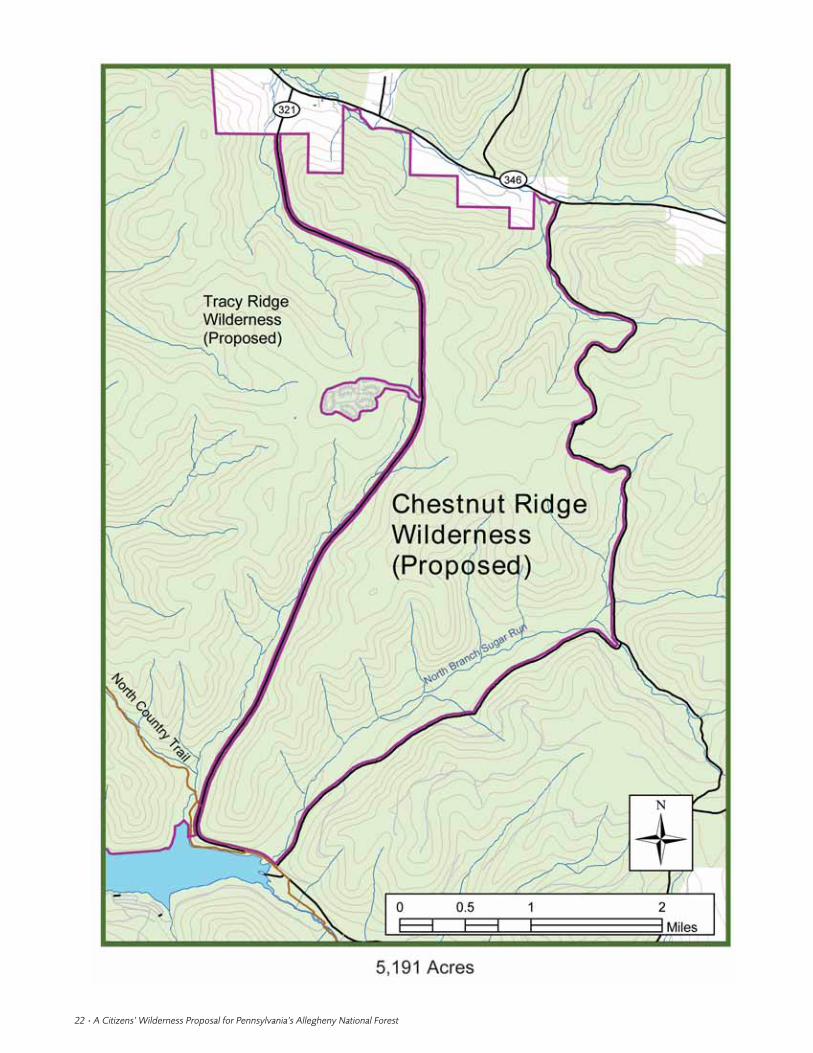
2. chestnut ridge wilderness– proposed
Citizen Proposed Acreage: 5,191Current Status: Management Area 6.1County: McKeanTownship: CorydonRanger District: BradfordUSGS topographic maps: Cornplanter Run, StickneyLow Elevation: 1,350'High Elevation: 2,250'
This area is unroaded with an impressive forest cover ofhemlock and black birch in the lowlands along theNorth Branch Sugar Run.Red,white, and chestnut oakdominate on the high plateau.Remarkably, hundreds ofhealthy young American chestnut trees can be found
here as well, hence theinspiration for the nameof our proposed wilder-ness.Much of the area liesabove 2,000' in elevation.The proposed wildernesshas high ecological valueand provides high qualityhabitat for a variety ofwildlife, including blackbears, fishers, and rat-tlesnakes, as well asCerulean Warblers andother migratory song-birds dependent onunfragmented forest.
During the late 1970’sthere was a program of‘preroading’ areas of theANF that had lowerproduct value in anticipa-tion of logging the areaslater when the treesmatured. Considerationwas given to buildingseveral roads intoChestnut Ridge underthe preroading program.However, since the tim-ber was smaller in diame-ter and there wasrelatively little of thecommercially valuableAllegheny HardwoodForest Type present, thenANF Forest Supervisor
John Butt decided not to pursue preroading for theChestnut Ridge area. According to one Forest Serviceforester, there is also less oil and gas beneath ChestnutRidge than in other parts of the Forest.
A hotel was once located at the mouth of NorthBranch Sugar Run where famous bands such as theCount Basie Orchestra and the Tommy Dorsey Bandplayed. Several sites along North Branch Sugar Runwere once logging camps. Designation of the proposedChestnut Ridge and Tracy Ridge Wilderness areaswould result in the establishment of nearly 15,000 acresof wilderness, separated only by a relatively lightly used(according to Pennsylvania Department of Transporta-tion data) segment of State Route 321.
Proposed Chestnut Ridge Wilderness
1.There are more than a dozen informal pull-offsalong Forest Roads 271 and 137,which bound the pro-posed wilderness to the south and to the east, wheresemi-primitive campsites including fire rings have beenestablished near the roads. These camp sites shouldremain open but outside the wilderness boundary, forthe use of those wishing to camp near the road and thenhike in to enjoy the wilderness.
2. The Forest Service owns a tract of the mineralrights underlying the proposed Chestnut RidgeWilderness, located along State Route 321 across fromthe Tracy Ridge campground.We recommend that theremaining mineral rights underlying the area beacquired by the Forest Service and not leased out, usingthe process developed during the Hickory Creek andAllegheny Islands Wilderness designation in 1984 as amodel, to assure permanent protection of the ChestnutRidge wilderness resource.
Friends of Allegheny Wilderness • 23
Hiker standing to the right of a sixty foot
tall American chestnut (Castenea dentata).
Photo by Kirk Johnson
North Branch Sugar Run, Chestnut Ridge. Photo by Kirk Johnson

24 • A Citizens’ Wilderness Proposal for Pennsylvania’s Allegheny National Forest

3. clarion river wilderness –proposed
Citizen Proposed Acreage: 6,009Current Status: Management Area 6.1County: ElkTownships: Ridgway, Spring CreekRanger District: MarienvilleUSGS topographic maps: Carman, Hallton,Portland Mills
Low Elevation: 1,300'High Elevation: 1,850'
The proposed Clarion River Wilderness lies entirely inElk County near the town of Ridgway, along a portionof the Clarion River that was designated a NationalWild and Scenic River in 1996. The Forest Service hasidentified 4,241 acres within the proposed wilderness asan inventoried roadless area.The area is cloaked by amaturing second-growth forest cover that is closed andmostly non-coniferous, though there are fine specimensof white pine present and areas of hemlock cover. Onthe steep drop south to the Clarion River, dense thick-ets of rhododendron (Rhododendron spp.) and mountainlaurel can be found.
The proposed Clarion River Wilderness extendswest from near the Ridgway Country Club to, andincluding, the ghost town of Arroyo. The proposednorthern boundary is the Laurel Mill Road. Approxi-mately 14 miles of the National Wild and Scenic Clar-ion River frontage would be included in thedesignation.
The Clarion River corridor is experiencing rapidgrowth in recreational use. Canoers and campers fromaround the country are aware of the area’s rich scenicbeauty and visit in increasing numbers each year. Alsowithin the proposed wilderness are several archaeolog-ical sites related to lumbering history in Elk County.According to local historian John D. Imhof, theseinclude the towns of Arroyo (1831–1930), Bear CreekEddy (1860–1890), Carman (1890–1955), Irwintown(1851–1880), Lily Pond (1850–1900), and PortlandMills (1803–present).
The area has high ecological value and provides highquality habitat for a variety of wildlife, including blackbears, fishers, and migratory songbirds. On multipleoccasions FAW inventory volunteers have sightedmigrant songbird species such as the Scarlet Tanager(Piranga olivacea) and Baltimore Oriole (Icterus gallbula)in the Clarion River roadless area. Animals that also usethe area and have been sighted include white-taileddeer,Turkey Vultures (Cathartes aura),Turkey, and porcu-pine. In the past the Clarion River has been considered
polluted, but since its designation as a National Wildand Scenic River in 1996, clean-up has been ongoingand great strides have been made. Biologists expect theprospective Clarion River Wilderness to be highpotential Bald Eagle habitat within ten years.
The Clarion River appears to be the southern mar-gin for several aquatic insects of special concern.Theseinsects, recorded along the Arroyo to Portland Millsstretch of the river, are as follows: ski-tailed emerald(Somatochlora elongate), superb jewelwing (Calopteryxamata), zebra clubtail (Stylurus scudderi ), harpoon club-tail (Gomphus descriptus), zorro clubtail (Lanthus parvu-lus), twin-horned snaketail (Ophiogomphus mainensis),ocellated darter (Boyeria grafiana), brotherly clubtail(Gomphus fraternus), green-faced clubtail (Gomphusviridifrons), and moustached clubtail (Gomphus adelphus).
The area also offers outstanding opportunities forbackcountry recreation, education, and scientificresearch.Approximately half of the popular Laurel Millcross-country ski and hiking trail lies south of LaurelMill Road within the proposed Clarion River Wilder-ness.
Proposed Clarion River Wilderness
1.The proposed wilderness is bounded roughly bythe Laurel Mill Road on the north, the Clarion Riveron the south, and the Arroyo Road and private prop-erty on the west.
2. A power line and below-ground pipeline passthrough the proposed wilderness in a north-southdirection at the western end of the proposed wilder-ness. Specific language should be included in any ANFwilderness legislation to allow for continued mainte-nance of these utilities.
3.We recommend that the Forest Service acquire, ona willing seller basis, a 452-acre inholding of privateland near Mill Creek for inclusion in the Clarion RiverWilderness.
Friends of Allegheny Wilderness • 25
The National Wild and Scenic Clarion River. Photo by Bob Stoudt
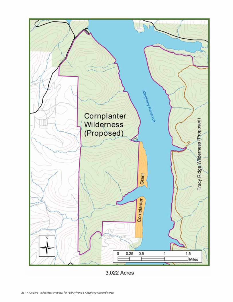
26 • A Citizens’ Wilderness Proposal for Pennsylvania’s Allegheny National Forest

4. cornplanter wilderness –proposed
Citizen Proposed Acreage: 3,022 Current Status: National Recreation Area designatedas such under the Pennsylvania Wilderness Act of1984. Management Area 6.4
County:WarrenTownship: ElkRanger District: BradfordUSGS topographic maps: Cornplanter RunLow Elevation: 1,328 'High Elevation: 2,122 '
This area is currently part of the Allegheny NationalRecreation Area that was designated under the 1984Pennsylvania Wilderness Act. Covered by a densecanopy of maturing second-growth forest, the area pro-vides high-quality habitat for black bears, rattlesnakes,and Bald Eagles.
There is a known Bald Eagle’s nest near the southernend of the proposed Cornplanter Wilderness.The BaldEagle is a species sensitive to human intrusion, and thePGC does not wish the exact location of nest sites to bedistributed. Questions concerning the nesting occur-rence should be posed to the PGC or the ecological sta?at the ANF.
The area is entirely unroaded except for a marginal,closed road beginning near Red Oak Campgroundleading to Hooks Brook campground on the AlleghenyReservoir. This road is closed to public access, but theForest Service did use it in fall 2002 to access HooksBrook campground in order to replace the pit toilets
there. The road was closed and reseeded when the proj-ect was completed.
During the American Revolution, in August 1779the American Colonel Brodhead led a force of 600troops up the Allegheny River to the Seneca townsnear the New York and Pennsylvania border. TheSenecas had fled, but their towns, containing 130homes, were burned. Great quantities of corn and veg-etables were destroyed, and plunder valued at $330,000was taken.The Iroquois were forced to sign a treaty atFort Stanwix in October 1784, selling to Pennsylvaniafor $5,000 all unceded land in the state except a reser-vation of a few hundred acres for Chief Cornplanter ofthe Senecas. Most of this Cornplanter land is nowunder water due to construction of the Kinzua Dam inthe 1960s, but a small tract along the west shore of thereservoir is still owned by the heirs of Chief Corn-planter.This land is distinct from the reservation of theSeneca Nation of Indians, which lies along the rivernorth of the New York state line. The CornplanterLandowners Association oversees the Cornplanter landgrant here. This grant land would lie adjacent to, butwould not be affected by, a Cornplanter Wildernessdesignation.
All the land surrounding the Allegheny Reservoir issacred to the Seneca Nation.There are known prehis-toric archeological sites, routes of travel, and other evi-dence of past Native American uses within theproposed wilderness.
Proposed Cornplanter Wilderness
1.The area of our proposed wilderness is boundedroughly by the Warren-Onoville Road on the north-west, Webb’s Ferry boat launch on the north, theAllegheny Reservoir on the east (excluding the HooksBrook campground and Cornplanter Land Grant),Camp Olmstead and the Camp Olmstead Road on thesouth,and theANF proclamation boundary on the west.
2. FAW recommends cooperation with the SenecaNation in their efforts to retain full access to the Corn-planter Grant land.
3.Where the boundary of the proposed CornplanterWilderness is coterminous with the Allegheny Reser-voir, we recommend boundary placement to be at1,365 ', the maximum pool level of the AlleghenyReservoir.
Friends of Allegheny Wilderness • 27
The proposed Cornplanter Wilderness as seen from the Allegheny
Reservior.
Photo by Kirk Johnson

28 • A Citizens’ Wilderness Proposal for Pennsylvania’s Allegheny National Forest

5. hickory creek wildernessaddition – proposed
Citizen Proposed Acreage: 1,780Current Status: Management Area 6.1County:WarrenTownship: WatsonRanger District: BradfordUSGS topographic maps: Cherry Grove, CobhamLow Elevation: 1,550'High Elevation: 1,900'
This area was originally identified as potential wilder-ness in the early inventories by the Pennsylvania Chap-ter of the Sierra Club and was included in early versionsof the EWAA legislation supported by PennsylvaniaSenators Hugh Scott and Richard Schweiker.
The current proposed wilderness addition is sepa-rated from the main acreage of the existing HickoryCreek Wilderness by a 33 '-wide electric line corridor(maintained by side trimming, hand-cutting and deerbrowsing) that supplies power to Hearts Content camp-ground, camps and residences on the east side of theHickory Creek Wilderness. The expanded HickoryCreek Wilderness would complement FAW’s proposedwilderness and NRA designation at Allegheny Front,Hearts Content, and Minister Valley. These areas, alongwith the existing Hickory Creek Wilderness, have incommon being traversed by the popular 11-mile Tan-bark hiking trail, which runs east from the AlleghenyRiver until it meets the NCT in the proposed MinisterValley National Recreation Area. Adjacent to HickoryCreek is the Hearts Content picnic area, whichincludes a small remnant of an old-growth forest com-munity. Expanding the Hickory Creek wilderness willin time increase the amount of old-growth forest com-munities in this area, increase forest linkage, anddecrease forest fragmentation.
The 1,780 acres contain many features worth pro-tecting, including beautiful maturing second-growthforests on the headwaters of East Hickory Creek; bogs,beaver ponds, and meadows along the creek and twotributaries; and moss-covered cliffs and boulders morethan 25' in height. This area contains many known pre-historic archeological sites and is therefore of great his-toric value. Projectile points dated to 5,000 BP havebeen found in this area.
Designation of this proposed wilderness additionwould bring nearly the entire East Hickory Creekwatershed—a state designated Wilderness Trout Streamfrom its headwaters to the point where it leaves theHickory Creek Wilderness Area at Forest Road 119—under wilderness protection. The Pennsylvania NaturalDiversity Inventory (PNDI) has identified East Hick-ory Creek as a high gradient clearwater creek aquaticcommunity because this stream is recognized by theDEP as an Exceptional Value Waters. Exceptional Valuestreams are potential examples of high biodiversityqualities and are therefore considered exemplary natu-ral aquatic communities.
Ideally we would like to see the powerline movedfrom the current corridor between the Hickory CreekWilderness and proposed Hickory Creek Wildernessaddition. Perhaps this power line could be routed paral-lel to the Heart’s Content Road. Such action, however,is not necessary to precipitate the area’s designation asan addition to the Hickory Creek Wilderness.
Proposed Hickory Creek Wilderness Addition
This proposed expansion of the Hickory CreekWilderness Area is bounded roughly on the north andeast by Heart’s Content Road and on the west by StateRoute 337.
Friends of Allegheny Wilderness • 29
Shelf fungi find a home on coarse woody debris lying on the forest floor.
Photo by Scott MacDonald
Beaver pond along East Hickory Creek, a State designated Wilderness
Trout Stream, in the proposed Hickory Creek Wilderness addition.
Photo by Kirk Johnson

30 • A Citizens’ Wilderness Proposal for Pennsylvania’s Allegheny National Forest

6. morrison run wilderness –proposed
Citizen Proposed Acreage: 6,887Current Status: Management Areas 6.1, 6.2Counties: McKean,WarrenTownships: Corydon, Hamilton (McKean County),Mead (Warren County)
Ranger District: BradfordUSGS topographic maps: Cornplanter Bridge,Westline
Low Elevation: 1,328'High Elevation: 2,150'
Morrison Run is a tributary of what once was KinzuaCreek, now Kinzua Bay since the construction of theKinzua Dam in the 1960s. The proposed MorrisonRun Wilderness lies along the Kinzua Bay. A centuryago in this area, as Taber (1975) points out, “The sightand sound of the geared locomotive was seen and heardin the valley for sixty-two years, a length of time notrecognized throughout Pennsylvania.” In about 1885 or1886, Joseph W. Neily purchased timber on warrants5594 and 5575; 2,500 acres are recorded purchased byhim.The mill was located about a half mile up ChappelFork. His narrow gauge railroad probably ran off theKinzua Railroad and up Hemlock Run about twomiles (Taber 1975). Several known prehistoric NativeAmerican sites lie along Morrison Run in the northernportion of the proposed wilderness.
The Morrison Trail, a 10.8-mile loop trail, offers apleasant two-to three-day backpacking experience or ashorter day hike.This trail leads to Morrison Camp-ground on Kinzua Bay, a primitive area of 32 boataccess campsites, which include picnic tables, fire rings,vault toilets, and pump water. Slopes along the reservoirand along the small streams are steep with large boul-ders on the steeper hillsides. Most of the area is heavilyforested in second-growth timber, primarily oak andhickory.Hemlock is found along the streams, and splen-did old white pines can be found in scattered locations.The month of June provides a perfect opportunity tosee the mountain laurel in bloom. Opportunities toview deer, squirrel, grouse, beaver, and turkey are alsogood. A rare emergent wetland plant known as a threadrush (Juncus filiformis) has been recently recorded nearChappel Bay along the southern edge of the proposedwilderness. This is a Pennsylvania Rare state-listedspecies. Its discovery in 1991 coincided with droughtconditions resulting in lower water levels in the reser-voir and exposed mudflat habitats.
The NCT passes through the eastern end of the pro-posed Morrison Run Wilderness from the southwest to
the northeast, following the beautiful Hemlock Rundrainage. On the west end of the proposed area is thepopular Rimrock Drive and Overlook.This feature wasformally dedicated on Friday, October 9, 1964 by Con-gressman Albert Johnson (The Bradford Era 1964).TheRimrock Drive and Overlook is not inside the bound-ary of our proposed wilderness but is close enough forusers of the Rimrock area to use the area as a startingpoint for their Morrison Run Wilderness experience.Surrounded by the proposed Morrison Run Wilder-ness, and located at the Rimrock Overlook, is a geo-logic feature classified by the PNDI as an “erosionalremnant.” This feature has been included in at least oneDCNR publication identifying significant geologicalfeatures in the state.
Proposed Morrison Run Wilderness
1.We recommend that the developed Morrison Runcampground be excluded from the proposed wilderness.
2. We recommend that the Rimrock Drive andOverlook be excluded from the wilderness designationby ‘cherrystemming’ the area from the boundary.Werecommend that the wilderness boundary be set at 50'from the Rimrock Drive.
3.We recommend that the Kinzua Beach Manage-ment Area 7 land along Kinzua Bay, zoned for “Largescale recreation areas or resorts,” be excluded from theproposed wilderness in deference to those who maywish to develop a rustic lodge at this location.This areahas already been developed as a public day-use beach.
4.The Forest Service owns three small tracts of min-eral rights between Campbell Run and Morrison Runalong Kinzua Bay, and another between Morrison Runand Hemlock Run along Chappel Bay within the pro-posed Morrison Run Wilderness.They do not allowsurface occupancy to access these deposits if leased.Werecommend that the Forest Service acquire the mineralrights underlying the remainder of the proposedwilderness.
Friends of Allegheny Wilderness • 31
Rock outcropping along Morrison Run. Photo by Kirk Johnson

32 • A Citizens’ Wilderness Proposal for Pennsylvania’s Allegheny National Forest

7. tionesta wilderness –proposed
Citizen Proposed Acreage: 14,960Current Status: Management Areas 3, 6.1 and 8.Approximately 4,110 acres of old-growth forest arerecognized as a National Natural Landmark at theTionesta Scenic and Research Natural Areas
Counties: Elk, McKean,WarrenTownships: Highland (Elk Co.); Hamilton,Wetmore(McKean Co.); Sheffield (Warren Co.)
USGS topographic maps: Ludlow, Russell CityLow Elevation: 1,375'High Elevation: 2,000 '
This is the largest old-growth forest in the state ofPennsylvania, and indeed in the eastern United Statesbetween the Great Smoky Mountains and the Adiron-dacks.The Forest Service has characterized the TionestaResearch Natural Area as “one of the most valuableold-growth remnants in the eastern U.S.…evidencedby the 10-fold increase in research activity on the areaover the past decade” (Nowak and Nelson 1997).TheTionesta area was once part of a colonial land grant tothe Holland Land Company that was later held by smalltanneries in Sheffield as a reserve for hemlock tanbark.This land was later purchased by the U.S.Leather Com-pany and subsequently turned over to the CentralPennsylvania Lumber Company. In 1871 H.J. Brooksestablished a tannery at Brookston that became the For-est Tanning Company in 1884 (Casler 1973). However,even the presence of this tannery, which requiredsignificant quantities of hemlock bark, did not affecttoday’s Tionesta Scenic and Research Natural Areas.There are six known prehistoric sites along the EastBranch Tionesta Creek within the proposed TionestaWilderness Area, as well as several historic loggingcamps.
To preserve a remnant of this climax forest, the lastremaining area of uncut hemlock-beech forest was pur-chased by the U.S. Government in 1936. At the urgingof forest scientist Theodora Cope, in 1940 approxi-mately 2,000 acres were formally dedicated as a scenicarea and another 2,000 were dedicated as a researchnatural area (RNA).
On July 23, 1973, the Tionesta Scenic and ResearchNatural Areas were added to the National Registry ofthe National Landmarks Program.The objectives of theNatural Landmarks Program are (1) to encourage thepreservation of sites illustrating the geological and eco-logical character of the United States, (2) to enhancethe educational and scientific value of sites thus pre-served, (3) to strengthen cultural appreciation of naturalhistory, and (4) to foster a greater concern for the con-servation of the Nation’s natural heritage. In 1999 theTionesta old-growth was recognized as a PennsylvaniaImportant Bird Area. All of these recognitions are com-patible with wilderness designation.
An estimated 120 oil and gas wells are located withinthe Tionesta old-growth (Robert T. Jacobs, RegionalForester, U.S. Forest Service Eastern Region, Milwau-kee,Wisconsin, pers. correspondence). The ANF ownsthe mineral rights below the Research Natural Area,but not below the Scenic Area (Nowak and Nelson1997). There are 16 active oil wells in the RNA, but asthese stop producing over time, they will not beredrilled to restore production and will be phased out aspart of the 1987 purchase agreement.
We suggest that the region of the ANF demarcatedby U.S. Route 6, and State Routes 66 and 948, with the4,100-acre Tionesta Scenic and Research Natural Areasold-growth as its core, is a strong candidate for wilder-ness designation (Johnson 1999, 2001, 2002). This pro-
Friends of Allegheny Wilderness • 33
Tionesta Scenic Area. Photo by Scott MacDonald
Exploring the Tionesta Research Natural Area, February 2002.
Photo by Tim Walter

posed wilderness lies partially in Elk,McKean, and War-ren counties. Protection for the unique 4,100-acreTionesta old-growth would be bolstered by virtue ofbeing encompassed by a larger wilderness area. Giventime, the complete Tionesta Wilderness Area asdescribed above would largely come to resemble itsnative old-growth forest core, as characterized byBjorkbom and Larson (1977):
Most of the Allegheny Plateau outside the Tionesta Scenic andNatural Areas is now dominated by second-growth stands ofintolerant species resulting from the commercial logging operationsof the 1890–1930 era.These second-growth stands will eventu-ally revert to hemlock/beech/sugar maple types like those in theTionesta tract if left undisturbed long enough.
With 500-year-old, 40" diameter ancient hemlocks acommon occurrence, the Tionesta Scenic and ResearchNatural Areas represent some of the last primary forestin the eastern United States. These areas provide highquality habitat used by rare species such as the Indianabat, northern long-eared bat (Myotis septentrionalis)(Gannon 2000), and yellow-bellied flycatcher (Empi-donax flaviventris).Tionesta is one of the few confirmedbreeding locations of the yellow-bellied flycatcher inPennsylvania (Crossley 1999). Songbirds and amphib-ians show greater abundance (U.S.Forest Service 1995),and brook trout (Salvelinus fontinalis) find more diversehabitat due to large woody debris contributions thatsignificantly affect fluvial processes (Terrick 1996) inthe Tionesta old-growth than in the surrounding land-scape. Also, Rooney and Dress (1997) found greatertree species richness within the Tionesta old-growththan in the surrounding secondary forest.
With a baseline old-growth core surrounded byadditional wilderness-qualifying forest land, the pro-
posed Tionesta Wilderness Area would benefit the sci-entific community as an exceptional site for studyingsuccessional processes (Noss 1991, Saunders et al. 1991,Rooney and Dress 1997, Cole 2000).This wildernessdesignation would not dissolve the existing RNA des-ignation. Following examples such as the McCormickRNA in the McCormick Wilderness of Michigan’sOttawa National Forest and The Bowl RNA in theSandwich Range Wilderness of New Hampshire’sWhite Mountain National Forest, the Tionesta RNAshould continue to be managed as such. Both of theseRNAs (like the Tionesta RNA both are located in theEastern Region of the USDA Forest Service) existedlong before the surrounding wilderness was designated,which is analogous to our Tionesta Wilderness pro-posal. There will be no conflict with ongoing andfuture research in this area.The Tionesta Scenic andResearch Natural Areas provide a unique environmentfor conducting research. The proposed TionestaWilderness would provide a baseline reference site, anarea to study ecological processes and disturbanceregimes (Ruffner and Abrams 2003), and a place tostudy wildlife habitat relationships. More than 100
34 • A Citizens’ Wilderness Proposal for Pennsylvania’s Allegheny National Forest
Large woody debris in the 1985 tornado blowdown, Tionesta Scenic Area.
Photo by Scott MacDonald
Tionesta Research Natural Area.
Photo by Bob Stoudt
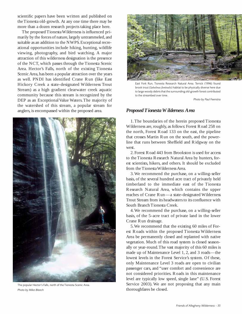
scientific papers have been written and published onthe Tionesta old-growth. At any one time there may bemore than a dozen research projects taking place here.
The proposed Tionesta Wilderness is influenced pri-marily by the forces of nature, largely untrammeled, andsuitable as an addition to the NWPS.Exceptional recre-ational opportunities include hiking, hunting, wildlifeviewing, photography, and bird watching. A majorattraction of this wilderness designation is the presenceof the NCT, which passes through the Tionesta ScenicArea. Hector’s Falls, north of the existing TionestaScenic Area, has been a popular attraction over the yearsas well. PNDI has identified Crane Run (like EastHickory Creek a state-designated Wilderness TroutStream) as a high gradient clearwater creek aquaticcommunity because this stream is recognized by theDEP as an Exceptional Value Waters.The majority ofthe watershed of this stream, a popular stream foranglers, is encompassed within the proposed area. Proposed Tionesta Wilderness Area
1.The boundaries of the herein proposed TionestaWilderness are, roughly, as follows: Forest Road 258 onthe north, Forest Road 133 on the east, the pipelinethat crosses Martin Run on the south, and the power-line that runs between Sheffield and Ridgway on thewest.
2. Forest Road 443 from Brookston is used for accessto the Tionesta Research Natural Area by hunters, for-est scientists, hikers, and others. It should be excludedfrom the Tionesta Wilderness Area.
3.We recommend the purchase, on a willing-sellerbasis, of the several hundred acre tract of privately heldtimberland to the immediate east of the TionestaResearch Natural Area, which contains the upperreaches of Crane Run—a state-designated WildernessTrout Stream from its headwaters to its confluence withSouth Branch Tionesta Creek.
4.We recommend the purchase, on a willing-sellerbasis, of the 5-acre tract of private land in the lowerCrane Run drainage.
5.We recommend that the existing 60 miles of For-est Roads within the proposed Tionesta WildernessArea be permanently closed and replanted with nativevegetation. Much of this road system is closed season-ally or year-round.The vast majority of this 60 miles ismade up of Maintenance Level 1, 2, and 3 roads—thelowest levels in the Forest Service’s system. Of these,only Maintenance Level 3 roads are open to civilianpassenger cars, and “user comfort and convenience arenot considered priorities. Roads in this maintenancelevel are typically low speed, single lane” (U.S. ForestService 2003). We are not proposing that any mainthoroughfares be closed.
Friends of Allegheny Wilderness • 35
The popular Hector’s Falls, north of the Tionesta Scenic Area.
Photo by Mike Bleech
East Fork Run, Tionesta Research Natural Area. Terrick (1996) found
brook trout (Salvelinus fontinalis) habitat to be physically diverse here due
to large woody debris that the surrounding old-growth forest contributed
to the streambed over time.
Photo by Paul Feenstra

36 • A Citizens’ Wilderness Proposal for Pennsylvania’s Allegheny National Forest

8. tracy ridge wilderness –proposed
Citizen Proposed Acreage: 9,705Current Status: National Recreation Area under the 1984 Pennsylvania Wilderness Act. ManagementArea 6.4
Counties: McKean,WarrenTownships: Corydon (McKean Co.), Mead (Warren Co.)
Ranger District: BradfordUSGS topographic maps: Cornplanter Run, StickneyLow Elevation: 1,328'High Elevation: 2,200'
Beginning with NativeAmerican times, the rich historyof this area continues with rafting and river transporta-tion, lumbering,oil and gas discoveries, establishment ofthe ANF, and most recently the creation of theAllegheny Reservoir behind Kinzua Dam. Extendingfor 6.5 miles along the east bank of the AlleghenyReservoir, the proposed Tracy Ridge Wilderness is oneof the largest undisturbed areas in the ANF.
Human activity in the area has always been concen-trated along the Allegheny River, the major early routeof transportation north into New York State.The bot-tom lands along the river (now flooded by KinzuaDam) sheltered several Seneca villages. All of the landsurrounding the Reservoir is sacred to the SenecaNation.There was once a particularly large Seneca vil-lage at the mouth of Kinzua Creek, a little less thanthree miles southwest of the study area. Senecas huntedwithin the proposed Tracy Ridge Wilderness, andarrowheads and other artifacts are frequently foundhere. Archaeologists believe that Native Americans usedthe area’s rock outcroppings on high ground for shelterduring hunting expeditions.
Permanent European settlement apparently did notbegin until 1827, when Philip Tome built a shanty inwhat became the village of Corydon,near the mouth ofWillow Creek. Others arrived later that year and millswere soon built, but the population did not grow rap-idly. An 1878 atlas shows a road along the east bank ofthe river, with the communities of Corydon at themouth of Willow Creek and Cornplanter P.O. at themouth of Sugar Creek.The only roads leading inlandran along these two creeks. Land throughout the studyarea was never more than lightly populated by whitesettlers (Pratt 1973b).
Tracy Ridge is a plateau elevated above theAllegheny Reservoir, dissected by small runs that droprapidly to the reservoir. The highest land (2,245' nearTracy Ridge campground) is in the middle on the east
side, almost equally distant from the reservoir and northand south bounding bays. But all the high lands of thearea are connected—one could walk from the northend to the south end of the proposed Tracy RidgeWilderness without ever dropping below 1,900'. Thereare rock ledges behind the Tracy Ridge Campgroundand large boulders along the hillside between WhiskeyRun and Tracy Run. Rock exposed along the edge ofthe reservoir is rich in fossils between Handsome Lakecampground and Johnnycake Run.The largest streamsdraining the area are on its eastern edge—Nelse Rundrops south for four miles to Sugar Bay, while Co?eyRun drops north for two miles to Willow Creek.
The Bald Eagle is a species sensitive to human intru-sion and the PGC does not wish the exact location ofnest sites to be distributed. A nesting pair has used thispart of the ANF in recent years. Questions concerningthis nesting occurrence should be posed to the PGC orecological staff at the ANF. The proposed Tracy RidgeWilderness is heavily forested in oak, white pine, hem-lock, and other species, and provides high quality habi-tat for many species of native Allegheny Plateau wildlifein addition to the Bald Eagle.
Friends of Allegheny Wilderness • 37
A remarkable maturing forest cloaks the proposed Tracy Ridge
Wilderness Area.
Photo by Kirk Johnson

Four developed campgrounds are located on theperiphery of the area:Willow Bay Recreation Area onWillow Bay; two boat-in campgrounds, HandsomeLake and Hopewell, on the reservoir without roadaccess; and the Tracy Ridge Campground off Route321 on the central hilltop.These campgrounds wouldbe convenient access points for the more serious TracyRidge Wilderness hikers. The two boat-in camp-grounds, Handsome Lake and Hopewell, are accessibleonly by water or by hiking trails. Each has a hand-oper-ated water pump and vault toilet building, picnic tables,and fire rings.
The Tracy Ridge Campground, located on a flat hill-top in the center of the area just south of the Johnsonfarm,was built in 1972. It has 119 developed camp sites,each containing a picnic table, fire ring, and tent pad.Hand-pumped water, vault toilets, and a trailer dumpstation are also available.The level of use at this camp-ground has been relatively low over the years. Two ofthe four loops often remain closed throughout the sea-son.When the Sierra Club surveyed this area in 1973, itwas reported that some Forest Service employeesseemed to regret building the campground in this loca-tion (Pratt 1973b).
Proposed Tracy Ridge Wilderness
1. Surrounded by water on three sides,Willow Bayand Route 346 provide the northern boundary, SugarBay the southern boundary. Bounded on the east byRoute 321, the area is generally 2 miles wide with abulge to 3 miles at the center on the hilltop open areaat the former Johnson farm site. On the west, theboundary would be the Allegheny Reservoir (set at themaximum pool level of 1,365'), between Willow Bayand Sugar Bay.
2.On the north side, the boundary for the wildernessarea would drop south from Route 346 at SchoolhouseHollow, follow the 1,400' contour line on the southside of Willow Creek and Willow Bay until passing theWillow Bay boat ramp and parking area where it wouldagain drop down to the 1,365' level, 50' west of the boatlaunch area.
3. Some 500 acres lie south of an undergroundpipeline at the southern end of Tracy Ridge. We rec-ommend that they be included in the designation andmanaged as part of the wilderness area, to which theybelong geographically.
4. We recommend the Handsome Lake andHopewell semi-developed campgrounds remain asdeveloped boat-in campgrounds, and that they remainoutside the wilderness boundary.
5. We recommend that the Tracy Ridge Camp-ground and its access road be excluded from the TracyRidge Wilderness through ‘cherry-stemming’ of theboundary here.
38 • A Citizens’ Wilderness Proposal for Pennsylvania’s Allegheny National Forest
A heavy snowfall blankets Nelse Run, proposed Tracy Ridge Wilderness Area.
Photo by Kirk Johnson
Ruffed Grouse (Bonasa umbellus).
Photo by Mike Bleech

In the late 1960s and early 1970s, Congress began des-ignating National Recreation Areas such as the GlenCanyon, Lake Chelan, as well as the Sawtooth NationalRecreation Areas (NRA). Since that time, numerousNRAs have been designated around the country.Unlike wilderness areas, there is no one law guidingmanagement of these areas; each one is unique. Alsounlike wilderness areas, motorized equipment andother management actions are sometimes allowedwithin NRAs, although the primary managementobjective of these areas is focused on recreation. NRAshave been designated to accommodate many types ofrecreation, from boating and public beaches to scenicdrives to wilderness, as well non-wilderness activitiessuch as energy generation. As the name implies, man-agement has emphasized recreational activities ratherthan new development uses.Where roads and/or offroad motorized travel have been permitted, it has beenlimited to designated routes.
The 1984 Pennsylvania Wilderness Act designatedthe 23,100-acre Allegheny National Recreation Area inthe ANF (see Appendix B).This is an example of anNRA with no motorized recreation permitted. TheAllegheny NRA consists mainly of the Tracy Ridge andCornplanter tracts on the shores of the AlleghenyReservoir, and the Allegheny Front tract south of War-ren along the Allegheny River. Previously in this docu-ment we outlined our proposals for designating thesethree areas as wilderness.
In addition to our eight proposed wilderness areas,we have identified three parcels of the ANF that cur-
rently have no special designation beyond their currentmanagement area classification set by the 1986 ForestPlan.We believe that the Hearts Content picnic andold-growth area, the popular Minister Valley area, andan extension of the existing Allegheny NRA south tothe Kinzua Dam on the west bank of the AlleghenyReservoir, would be appropriate additions to the NRAsystem in the ANF. These areas are wonderful naturaltracts that in our view do not quite fall under the crite-ria for wilderness designation.We believe they couldbest be enjoyed by the public as NRAs.
We further propose the Tanbark National RecreationArea, shown on page 46 of this document.This pro-posed NRA would combine proposed and existingwilderness as well as two of the above-mentioned pro-posed NRAs. Patterned after the early vision of theSierra Club in the 1970s, the Tanbark NRA wouldconsist of our proposed Allegheny Front Wilderness,Hickory Creek Wilderness addition, Hearts ContentNRA, Minister Valley NRA, as well as the existingHickory Creek Wilderness.
The Tanbark NRA would total more than 27,000acres, establishing for future generations a large perma-nent wildlands complex, traversed only by a few pavedroads.The purpose of a Tanbark NRA would be to cre-ate one relatively contiguous unit with several manage-ment components. The popular 11-mile Tanbarkhiking trail spans and ties together this proposed NRA.The NCT passes through the Minister Valley portion ofthe proposed Tanbark NRA, as does the AlleghenySnowmobile Trail. Such an area could enjoy increasedForest Service funding and would be a draw for visitorsseeking to enjoy activities ranging from snowmobiling,hunting, and camping in established facilities to wilder-ness hiking and backpacking.
Friends of Allegheny Wilderness • 39
The popular 11-mile Tanbark hiking trail spans and ties together the proposed
Tanbark National Recreation Area, its eastern terminus intersecting the North
Country National Scenic Trail in Minister Valley.
Photo by Kirk Johnson
national recreation areas

40 • A Citizens’ Wilderness Proposal for Pennsylvania’s Allegheny National Forest

1. allegheny nationalrecreation area addition –proposed
Citizen Proposed Acreage: 4,752 acresCurrent Status: Management Area 6.1County:WarrenTownships: Elk, GladeRanger District: BradfordUSGS topographic maps: Clarendon, CornplanterRun, Cornplanter Bridge, Scandia
Low Elevation: 1,328'High Elevation: 2,100'
This proposed Allegheny NRA addition would appro-priately extend protection for the west shore of theAllegheny Reservoir from the New York State line allthe way south to the Kinzua Dam. All of the land sur-rounding the Allegheny Reservoir is sacred to theSeneca Nation of Indians. According to an ANF arche-ologist, the Hodge Run valley at the northern end ofthe proposed NRA addition was likely a historic east-west Native American travel route.The hillsides andplateau tops in this area are heavily forested with apleasing mixture of oaks, maples, hemlock, and evenVirginia pine (Pinus virginiana). Large white pines onthe steep slope dropping down to the reservoir provideimportant nesting habitat for Bald Eagles. The largeboulder outcroppings in this area provide high qualityblack bear and timber rattlesnake habitat. Such out-croppings, as in other portions of the ANF, also pro-vided shelter for Native people during huntingexcursions.
There is a known Bald Eagle’s nest near the southernend of the proposed area near the Allegheny Reservoir.The Bald Eagle is a species sensitive to human intrusionand the PGC does not wish the exact location of nestsites to be distributed. A nesting pair has used this part
of the ANF in recent years. Questions concerning thisnesting occurrence should be posed to the PGC or theecological staff at the ANF.
A number of closed Forest Roads are within theboundary of the proposed Allegheny NRA addition.These roads are no longer used and are becoming over-grown. There is also a gravel pit at the southern end ofthe area overlooking the Kinzua Dam,where gravel wasobtained during construction of the dam.This gravelpit is no longer used, and natural succession has pro-duced a cover of white pine, shrubs, and other vegeta-tion. According to the manager of the Kinzua Dam,there will not be a need for access to this old gravel pitat any time in the future.
Proposed Allegheny NRA addition
The area is bounded roughly on the north by the ANFproclamation boundary and the road to the RoperHollow boat launch, on the east and south by the All-egheny Reservoir and Army Corps of Engineers land,and on the west by the ANF proclamation boundary.
Friends of Allegheny Wilderness • 41
Porcupines (Erethizon dorsatum) abound in the proposed addition to
the Allegheny National Recreation Area.
Photo by Kirk Johnson
The proposed Allegheny National Recreation Area addition as seen from
the Kinzua Point Information Center.
Photo by Kirk Johnson
An angler gets a strike on his line on the Allegheny Reservoir.
Photo by Mike Bleech

42 • A Citizens’ Wilderness Proposal for Pennsylvania’s Allegheny National Forest

2. hearts content nationalrecreation area –proposed
Citizen Proposed Acreage: 2,335 acresCurrent Status: Management Area 6.1County:WarrenTownships: Cherry Grove,WatsonRanger District: BradfordUSGS topographic maps: Cherry Grove, CobhamHigh Elevation: 1,950'Low Elevation: 1,660'
Designating the proposed 2,335-acre Hearts ContentNRA would augment wildlands protection in thewestern edge of the Forest.Together with the proposedAllegheny Front Wilderness,Hickory Creek Wildernessaddition, Minister Valley NRA designation, and theexisting Hickory Creek Wilderness, the wildlands com-plex created here would be more than 25,000 acres insize, separated only by three roads.
The proposed NRA will add an additional layer ofprotection to the existing 100-acre Hearts Contentold-growth tract, an important remnant of eastern old-growth featuring towering 300- to 400-year-old whitepine, hemlock, and beech. The Hearts Content old-growth is well known and has been exhaustively stud-ied by forest researchers over the years (Lutz 1930b,Morey 1936, Rooney and Dress 1997). Much has beendone over the years by the Forest Service to protect thisarea, and adding NRA protection to the area is a logi-cal next step in this progression.
This area remains largely undeveloped and providesgreat opportunities for solitude and dispersed recre-ation. The Hearts Content Scenic Interpretive Trailwinds about one mile through this forest stand andreturns to the picnic area. Cross-country skiing on theHearts Content cross-country ski trail, hiking on theTanbark Trail, and backpacking on the nearby HickoryCreek Wilderness trail are all available here.The Tan-bark Trail links up to the North Country Trail just tothe southeast of the area, which allows hikers to hikethe span of the ANF north to south using the proposedHearts Content National Recreation Area as a startingpoint.
Proposed Hearts Content National RecreationArea
1.The proposed NRA is bounded roughly by theHearts Content Road on the west and south, and StateGame Lands No. 29 on the north and east.
2.We recommend that snowmobile use be permittedto continue in the Hearts Content NRA on the desig-nated snowmobile trails.
3.The Forest Service owns the mineral rights underthe Hearts Content old-growth tract.We recommendthat the mineral rights underlying the remainder of theproposed Hearts Content NRA be acquired by theForest Service and not leased out, using the proceduredeveloped during the Hickory Creek and AlleghenyIslands Wilderness designation in 1984 as a model, toassure permanent protection of the area.
Friends of Allegheny Wilderness • 43
The Hearts Content old-growth forest was first protected by the Wheeler and
Dusenbury Lumber Company more than a century ago.
Photo by Kirk Johnson

44 • A Citizens’ Wilderness Proposal for Pennsylvania’s Allegheny National Forest

3. minister valley nationalrecreation area –proposed
Citizen Proposed Acreage: 7,390Current Status: Management Areas 6.1, 6.2 Counties: Forest,WarrenTownships: Howe (Forest Co.), Cherry Grove,Watson(Warren Co.)
Ranger District: BradfordUSGS topographic maps: Mayburg, Cherry GroveLow Elevation: 1,250'High Elevation: 1,950'
The 1,417 acres of the lower Minister Valley have beenformally recognized as roadless by the Forest Service.Minister Valley is a special place for many people. Itsscenic vistas, large rock formations, clear trout streams,forested areas, and diverse flora and fauna make it apopular recreation area. The Minister Creek camp-ground has six campsites situated along lower MinisterCreek just before its confluence with Tionesta Creek.Each site contains a picnic table, fire ring, and tent pad.Vault toilets and hand-pumped water are available. TheMinister hiking trail, a popular six-mile loop, starts andends at the campground and joins the NCT on thenorth end.Trout fishing is excellent in Minister Creekand also in nearby Tionesta Creek.The Tanbark Trailalso enters the area in the far northwest corner.
Dunham’s Mill was formerly the site of a mill oper-ated by the Dunham family, but the name has beenchanged to Dunham’s Siding at the northwest corner ofthe proposed Minister Valley NRA. It was named Dun-ham’s Siding because at one time it was the conver-gence point of seven logging railroads (Casler 1973). Anumber of well preserved historic logging camps liewithin the proposed NRA. And nowhere else in theANF are there are so many prehistoric archeologicalsites, perhaps because Minister Valley has the most denserock shelters of any drainage in Western Pennsylvaniaknown to archeologists.
Although the proposed Minister Valley NRA bearsevidence of recent human activity such as forest thin-ning and deer exclosures and several Forest Roadsentering from the north associated with the executionof the ANF’s Minister Watershed Project, the centraland southern reaches of the study area and creek bedsare untouched.The area boasts abundant possibilitiesfor solitude and peace, where one can commune withnature without the reminder of human activities. Thematuring second-growth forest within the study areacontains white oak, black cherry, hemlock, beech, andaspen. Wildlife observed here include deer, squirrel,
chipmunks, and hawks.Two species of special concern insects (one dragonfly
and one damselfly) have recently been recorded fromlower Minister Creek, found within the last few hun-dred yards before the stream mouth. The extent towhich these species are associated with Minister Creek,Tionesta Creek, or both, is presently unknown. Anadditional six special concern dragonflies have beenrecently recorded as inhabiting Tionesta Creek in thearea of the mouth of Minister Creek. No dragonfly ordamselfly species are officially listed as species of specialconcern by state government, but the ANF includesseveral on its list of Forest Sensitive Species, and thesespecies receive extra management consideration. Alsoin Tionesta Creek, in the general vicinity of the mouthof Minister Creek, is a recent record for the state listed(Pa.Threatened) bluebreast darter (Etheostoma camurum).Although this fish is not expected to inhabit MinisterCreek due to that stream’s smaller size, water quality inTionesta Creek is important to its survival. BecauseMinister Creek is a major tributary of Tionesta Creekin this area, there is a conservation connection.
Proposed Minister Valley National RecreationArea
1.The proposed NRA is made up entirely of the 6.1and 6.2 Management Areas bounded on the north byHearts Content Road and the Allegheny SnowmobileLoop trail, on the east by Minister Road, on the southby state route 666 and the Minister Campground, andon the west by Forest Roads 420, 250, and 116.
2.We recommend the purchase of the 90-acre pri-vate inholding near Forest Road 116 if the owner iswilling to sell.
3.We recommend that the established snowmobiletrail paralleling Hearts Content Road along the north-ern boundary of the proposed Minister Valley NRAremain open for snowmobile access and use.
Friends of Allegheny Wilderness • 45
Minister Valley roadless area. Photo by Kirk Johnson

46 • A Citizens’ Wilderness Proposal for Pennsylvania’s Allegheny National Forest

Abrams, M.D. and D.A. Orwig. 1996. A 300-year history of distur-bance and canopy recruitment for co-occurring white pine andhemlock in the Allegheny Plateau, USA. Journal of Ecology 84:353–363.
Allaby, M. 1994. The Concise Oxford Dictionary of Ecology. Oxford:Oxford University Press. 415 pp.
Bishop, L.L. 1925.The Allegheny National Forest – what, why, andwhere. Allegheny National Forest Supervisor, Essay. Pennsylva-nia Department of Forests and Waters, Harrisburg. 28 pp.
Bleech, M. 2002.Wilderness: the ultimate adventure. Warren TimesObserver. Page S-10. November 7.
Bjorkbom, J.C. and R.G. Larson. 1977.The Tionesta Scenic andResearch Natural Areas. General Technical Report NE-31, U.S.Department of Agriculture, Forest Service, Upper Darby, Penn-sylvania. 24 pp.
Bradford Era,The. 1964. Rimrock recreation area is dedicated. Page1. October 10.
Buck, J. 1999. Fishers of the forest. The Bradford Era: 1+. 27 May.Butt, J.P. 1984. Deer and trees on the Allegheny. Journal of Forestry
82: 468–471.Casler,W.C. 1976. Teddy Collins Empire:A Century of Lumbering in
Forest County. Lycoming Printing Company, Inc.Williamsport,Pennsylvania.
Cole, D.N. 2000. Paradox of the primeval: ecological restoration inwilderness. Ecological Restoration 18: 77–86.
Crossley, G.J. (ed.). 1999. Important Bird Areas in Pennsylvania:AGuide to Identifying and Conserving Critical Bird Habitat. Pennsyl-vania Audubon Society and Signal Graphics Printing, Mechan-icsburg, Penn. 219 pp.
deCalesta, D.S. 1994. Deer and diversity in Allegheny hardwoodforests: managing an unlikely challenge. Landscape and UrbanPlanning 28: 4–53.
Gannon, M.R. 2000. Survey of bats at Allegheny National Forestwith emphasis on the Indiana bat (Myotis sodalis): second yearreport. Unpublished report, Penn State University,Altoona,Penn. 22 pp.
Haney, J.C., M.Wilbert, C. DeGrood, D.S. Lee, and J.Thomson.1999. Gauging the ecological capacity of southern Appalachianreserves: does wilderness matter? Pp. 128–137 in McCool, S.F.,D.N. Cole,W.T. Borrie, and J. O’Loughlin, comps.Wildernessscience in a time of change conference – Volume 2:Wildernesswithin the context of larger systems May 23–27, Missoula,Montana. Proceedings RMRS-P-15-VOL-2. Ogden, Utah.U.S. Department of Agriculture, Forest Service, Rocky Moun-tain Research Station.
Hayes, C. 1974. Johnson says ANF out of wilderness bill. WarrenTimes Observer. Page 1. 22 October.
Hendee, J.C. and C.P. Dawson, eds. 2002. Wilderness Management:Stewardship and Protection of Resources and Values. 3rd Edition. Ful-crum Publishing, Golden, Colorado. 640 pp.
Henretta, J.E. 1929. Kane and the Upper Allegheny. Reprinted 1998.Gateway Press, Inc., Baltimore, Maryland. 357 pp.
Hough,A.F. 1936. A climax forest community on east TionestaCreek in northwestern Pennsylvania. Ecology 17: 9–28.
Johnson, N.L. 1999. A sleeping giant: Recreational and ecological poten-tial on the Allegheny National Forest, Pennsylvania. M.E.S. thesisessay.The Evergreen State College,Washington.
Johnson, N.L. 2001. A proposal for Tionesta wilderness designationin the Allegheny National Forest, Pennsylvania, USA. NaturalAreas Journal 21: 338–345.
Johnson, N.L. 2002. Honoring a wilderness vision: a proposal forPennsylvania’s Allegheny National Forest. Wild Earth 12 (2):63–67.
Klyza, C.M. 2001.Wildlands in the northeastern United States.International Journal of Wilderness 7(2): 8–10.
Loomis, J.B. 1999. Do additional designations of wilderness resultin increases in recreation use? Society and Natural Resources 12:481–491.
Lutz, H.J. 1930a. Original forest composition in northwesternPennsylvania as indicated by early land survey notes. Journal ofForestry 28: 1098–1103.
Lutz, H.J. 1930b.The vegetation of Hearts Content, a virgin forestin northwestern Pennsylvania. Ecology 11: 1–29.
Marquis, D.A. 1975.The Allegheny Hardwood Forests of Pennsyl-vania. General Technical Report NE-15, U.S. Department ofAgriculture, Forest Service, Upper Darby, Pennsylvania. 32 pp.
McGinnis, H. 1973.The East Hickory Creek Wilderness StudyArea:Allegheny National Forest. Allegheny Group, PennsylvaniaChapter, Sierra Club.
McIntyre, R., ed. 1995. The War Against the Wolf:America’s Campaignto Exterminate the Wolf. Stillwater, Minnesota:Voyager Press. 495pp.
Mohlenbrock, R.H. 1986.Tionesta forest, Pennsylvania. NaturalHistory November: 74–78.
Morey, H.F. 1936. Age-size relationships of Hearts Content, a vir-gin forest in northwestern Pennsylvania. Ecology 17: 251–257.
North Star. 2003. Milestones along the North Country Trail. NorthStar:The Magazine of the North Country Trail Association 12(2): 27.
Noss, R. 1991.What can wilderness do for biodiversity? Wild Earth(Summer): 51–55.
Nowak, C. and B. Nelson. 1997. Establishing critical boundarypoints and lines around and within the Tionesta Research Nat-ural Area. Unpublished report, U.S. Department of Agriculture,Forest Service,Warren, Pennsylvania. 5 pp.
Pratt, R.H. 1973a.Allegheny Front Wilderness Study:AlleghenyNational Forest, Pennsylvania. Pennsylvania Chapter, SierraClub.
Pratt, R.H. 1973b.Tracy Ridge Wilderness Study:AlleghenyNational Forest, Pennsylvania. Pennsylvania Chapter, SierraClub.
Rooney,T.P. 1995. Restoring landscape diversity and old-growthto Pennsylvania’s northern hardwood forests. Natural Areas Jour-nal 15: 274–278.
Rooney,T.P., and W.J. Dress. 1997. Species loss over sixty-six yearsin the ground-layer vegetation of Hearts Content, an old-growth forest in Pennsylvania, USA. Natural Areas Journal 17:297–305.
Ross, P.W. 1996. Allegheny Oil:The Historic Petroleum Industry on theAllegheny National Forest. U.S. Department of Agriculture. ForestService. 96 pp.
Ruffner, C.M. and M.D. Abrams. 2003. Disturbance history andstand dynamics along a topographic gradient in old-growthhemlock-northern hardwood forests of the Allegheny Plateau,USA. Natural Areas Journal 23: 98–113.
Rudzitis, G. and H.E. Johansen. 1991. How important is wilder-ness? Results from a United States survey. Environmental Man-agement 15: 227–233.
Friends of Allegheny Wilderness • 47
sources

Saunders, D.A., R.J. Hobbs, and C.R. Margules. 1991. Biologicalconsequences of ecosystem fragmentation: a review. ConservationBiology 5: 18–32.
Schiner, G.R. and G.E. Kimmel. 1972. Mississippian Stratigraphyof Northwestern Pennsylvania. U.S. Geological Survey.Wash-ington, D.C.: United States Government Printing O?ce.
Serfass,T.L., R.P. Brooks,W.M Tzilkowski, and D.H. Mitcheltree.1994. Fisher Reintroduction in Pennsylvania: Feasibility andReview. Pennsylvania Game Commission.
Sundquist, B., C.W.Yartz, and J. Richardson. 1999. AlleghenyNational Forest Hiking Guide. Fourth ed. Pittsburgh:AlleghenyGroup, Sierra Club. 186 pp.
Taber,T.T. 1974. Tanbark,Alcohol, and Lumber. Lycoming PrintingCompany, Inc. Williamsport, Pennsylvania. 112 pp.
Taber,T.T. 1975. Sawmills Among the Derricks. Lycoming PrintingCompany, Inc.Williamsport, Pennsylvania. 118 pp.
Terrick,T.D. 1996. A survey of the habitat and associated fish popula-tions of East Fork Run,Allegheny National Forest, Pennsylvania.M.S. thesis, Clarion University of Pennsylvania. Clarion. 66 pp.
U.S. Forest Service. 1975. Allegheny National Forest Forest Plan.Ralph J. Freeman, Forest Supervisor.
U.S. Forest Service. 1986. Allegheny National Forest Land andResource Management Plan. U.S. Department of Agriculture,Forest Service, Milwaukee,Wisconsin. 224 pp.
U.S. Forest Service. 1995. A landscape approach to providing late-successional forests and associated functions and values on theAllegheny National Forest. Unpublished report, U.S. Depart-ment of Agriculture, Forest Service,Warren, Pennsylvania. 18 pp.
U.S. Forest Service. 2002. Land areas of the National Forest Systemas of September 2001. FS-383, U.S. Department of Agriculture,Forest Service,Washington, D.C. 159 pp.
U.S. Forest Service. 2003. Allegheny National Forest Forest-wideRoads Analysis. Final Report. March. 167 pp.
United States Senate. 1974. Congressional Record. Eastern Wilder-ness Areas Act of 1974. 31 May: 17183-17199.
Watson, J. and B. Beach. 2000.The Wilderness Act Handbook. 4thEdition.The Wilderness Society,Washington, D.C. 84 pp.
Whitney, G.G. 1990.The history and status of the hemlock-hard-wood forests of the Allegheny Plateau. Journal of Ecology 78:443–458.
48 • A Citizens’ Wilderness Proposal for Pennsylvania’s Allegheny National Forest
An impressive six-point buck, with doe, white-tailed deer (Odocoileus vir-
ginianus) in the Allegheny National Forest.
Photo by Mike Bleech

appendix a:1964 wilderness actPublic Law 88-577 — Sept. 3, 1964An Act
To establish a National Wilderness Preservation System for the perma-nent good of the whole people, and for other purposes.
Be it enacted by the Senate and House of Representatives of the UnitedStates of America in Congress assembled,Short Title
sec. 1. This Act may be cited as the “Wilderness Act”wilderness system established — statementof policy
sec. 2. (a) In order to assure that an increasing population,accompanied by expanding settlement and growing mechanization,does not occupy and modify all areas within the United States andits possessions, leaving no lands designated for preservation and pro-tection in their natural condition, it is hereby declared to be the pol-icy of the Congress to secure for the American people of presentand future generations the benefits of an enduring resource ofwilderness. For this purpose there is hereby established a NationalWilderness Preservation System to be composed of federally ownedareas designated by Congress as “wilderness areas”, and these shall beadministered for the use and enjoyment of the American people insuch manner as will leave them unimpaired for future use andenjoyment as wilderness, and so as to provide for the protection ofthese areas, the preservation of their wilderness character, and for thegathering and dissemination of information regarding their use andenjoyment as wilderness; and no Federal lands shall be designated as“wilderness areas” except as provided for in this chapter or by a sub-sequent Act.
(b) The inclusion of an area in the National Wilderness Preserva-tion System notwithstanding, the area shall continue to be managedby the Department and agency having jurisdiction thereover imme-diately before its inclusion in the National Wilderness PreservationSystem unless otherwise provided by Act of Congress. No appropri-ation shall be available for the payment of expenses or salaries for theadministration of the National Wilderness Preservation System as aseparate unit nor shall any appropriations be available for additionalpersonnel stated as being required solely for the purpose of manag-ing or administering areas solely because they are included withinthe National Wilderness Preservation System.definition of wilderness
(c) A wilderness, in contrast with those areas where man and hisown works dominate the landscape, is hereby recognized as an areawhere the earth and its community of life are untrammeled by man,where man himself is a visitor who does not remain. An area ofwilderness is further defined to mean in this chapter an area ofundeveloped Federal land retaining its primeval character andinfluence, without permanent improvements or human habitation,which is protected and managed so as to preserve its natural condi-tions and which (1) generally appears to have been affected prima-rily by the forces of nature, with the imprint of man's worksubstantially unnoticeable; (2) has outstanding opportunities forsolitude or a primitive and unconfined type of recreation; (3) has atleast five thousand acres of land or is of sufficient size as to makepracticable its preservation and use in an unimpaired condition; and(4) may also contain ecological, geological, or other features of sci-entific, educational, scenic, or historical value.extent of system
sec. 3 (a) All areas within the national forests classified at least 30days before September 3, 1964 by the Secretary of Agriculture orthe Chief of the Forest Service as “wilderness”,“wild”, or “canoe”
are hereby designated as wilderness areas.The Secretary of Agricul-ture shall –
Within one year after September 3, 1964, file a map and legaldescription of each wilderness area with the Interior and InsularAffairs Committees of the United States Senate and the House ofRepresentatives, and such descriptions shall have the same force andeffect as if included in this chapter: Provided, however,That correc-tion of clerical and typographical errors in such legal descriptionsand maps may be made.
Maintain, available to the public, records pertaining to saidwilderness areas, including maps and legal descriptions, copies ofregulations governing them, copies of public notices of, and reportssubmitted to Congress regarding pending additions, eliminations, ormodifications. Maps, legal descriptions, and regulations pertainingto wilderness areas within their respective jurisdictions also shall beavailable to the public in the offices of regional foresters, nationalforest supervisors, and forest rangers.
(b) The Secretary of Agriculture shall, within ten years after Sep-tember 3, 1964, review, as to its suitability or nonsuitability forpreservation as wilderness, each area in the national forests classifiedon September 3, 1964 by the Secretary of Agriculture or the Chiefof the Forest Service as “primitive” and report his findings to thePresident.The President shall advise the United States Senate andHouse of Representatives of his recommendations with respect tothe designation as “wilderness” or other reclassification of each areaon which review has been completed, together with maps and adefinition of boundaries. Such advice shall be given with respect tonot less than one-third of all the areas now classified as “primitive”within three years after September 3, 1964, not less than two-thirdswithin seven years after September 3, 1964, and the remaining areaswithin ten years after September 3, 1964. Each recommendation ofthe President for designation as “wilderness” shall become effectiveonly if so provided by an Act of Congress. Areas classified as “prim-itive”on September 3, 1964 shall continue to be administered underthe rules and regulations affecting such areas on September 3, 1964until Congress has determined otherwise. Any such area may beincreased in size by the President at the time he submits his recom-mendations to the Congress by not more than five thousand acreswith no more than one thousand two hundred and eighty acres ofsuch increase in any one compact unit; if it is proposed to increasethe size of any such area by more than five thousand acres or bymore than one thousand two hundred and eighty acres in any onecompact unit the increase in size shall not become effective untilacted upon by Congress. Nothing herein contained shall limit thePresident in proposing, as part of his recommendations to Congress,the alteration of existing boundaries of primitive areas or recom-mending the addition of any contiguous area of national forest landspredominantly of wilderness value. Notwithstanding any other pro-visions of this chapter, the Secretary of Agriculture may completehis review and delete such area as may be necessary, but not toexceed seven thousand acres, from the southern tip of the GoreRange-Eagles Nest Primitive Area, Colorado, if the Secretary deter-mines that such action is in the public interest.
(c) Within ten years after September 3, 1964 the Secretary of theInterior shall review every roadless area of five thousand contiguousacres or more in the national parks, monuments and other units ofthe national park system and every such area of, and every roadlessisland within the national wildlife refuges and game ranges, underhis jurisdiction on September 3, 1964 and shall report to the Presi-dent his recommendation as to the suitability or nonsuitability ofeach such area or island for preservation as wilderness.The Presidentshall advise the President of the Senate and the Speaker of theHouse of Representatives of his recommendation with respect tothe designation as wilderness of each such area or island on which
Friends of Allegheny Wilderness • 49

review has been completed, together with a map thereof and adefinition of its boundaries. Such advice shall be given with respectto not less than one-third of the areas and islands to be reviewedunder this subsection within three years after September 3, 1964,not less than two-thirds within seven years of September 3, 1964and the remainder within ten years of September 3, 1964. A recom-mendation of the President for designation as wilderness shallbecome effective only if so provided by an Act of Congress. Noth-ing contained herein shall, by implication or otherwise, be con-strued to lessen the present statutory authority of the Secretary ofthe Interior with respect to the maintenance of roadless areas withinunits of the national park system.
(d) (1) The Secretary of Agriculture and the Secretary of the Inte-rior shall, prior to submitting any recommendations to the Presidentwith respect to the suitability of any area for preservation as wilder-ness –
give such public notice of the proposed action as they deemappropriate, including publication in the Federal Register and in anewspaper having general circulation in the area or areas in thevicinity of the affected land;
hold a public hearing or hearings at a location or locations con-venient to the area affected. The hearings shall be announcedthrough such means as the respective Secretaries involved deemappropriate, including notices in the Federal Register and in news-papers of general circulation in the area: Provided,That if the landsinvolved are located in more than one State, at least one hearingshall be held in each State in which a portion of the land lies;
at least thirty days before the date of a hearing advise the Gover-nor of each State and the governing board of each county, or inAlaska the borough, in which the lands are located, and Federaldepartments and agencies concerned, and invite such officials andFederal agencies to submit their views on the proposed action at thehearing or by no later than thirty days following the date of thehearing.
Any views submitted to the appropriate Secretary under the pro-visions of (1) of this subsection with respect to any area shall beincluded with any recommendations to the President and to Con-gress with respect to such area.
(e) Any modification or adjustment of boundaries of any wilder-ness area shall be recommended by the appropriate Secretary afterpublic notice of such proposal and public hearing or hearings asprovided in subsection (d) of this section. The proposedmodification or adjustment shall then be recommended with mapand description thereof to the President.The President shall advisethe United States Senate and the House of Representatives of hisrecommendations with respect to such modification or adjustmentand such recommendations shall become effective only in the samemanner as provided for in subsections (b) and (c) of this section.use of wilderness areas
sec. 4. (a) The purposes of this chapter are hereby declared to bewithin and supplemental to the purposes for which national forestsand units of the national park and national wildlife refuge systemsare established and administered and -
(1) Nothing in this chapter shall be deemed to be in interferencewith the purpose for which national forests are established as setforth in the Act of June 4, 1897 (30 Stat. 11), and the Multiple-UseSustained-Yield Act of June 12, 1960 (74 Stat. 215) (16 U.S.C. 528-531).
(2) Nothing in this chapter shall modify the restrictions and pro-visions of the Shipstead-Nolan Act (Public Law 539, Seventy-firstCongress, July 10, 1930; 46 Stat. 1020), the Thye-Blatnik Act (Pub-lic Law 733, Eightieth Congress, June 22, 1948; 62 Stat. 568), andthe Humphrey-Thye-Blatnik-Andresen Act (Public Law 607,Eighty-Fourth Congress, June 22, 1956; 70 Stat. 326), as applying to
the Superior National Forest or the regulations of the Secretary ofAgriculture.
(3) Nothing in this chapter shall modify the statutory authorityunder which units of the national park system are created. Further,the designation of any area of any park, monument, or other unit ofthe national park system as a wilderness area pursuant to this chap-ter shall in no manner lower the standards evolved for the use andpreservation of such park, monument, or other unit of the nationalpark system in accordance with sections 1, 2, 3, and 4 of this title, thestatutory authority under which the area was created, or any otherAct of Congress which might pertain to or affect such area, includ-ing, but not limited to, the Act of June 8, 1906 (34 Stat. 225; 16U.S.C. 432 et seq.); section 3(2) of the Federal Power Act (16 U.S.C.796(2)); and the Act of August 21, 1935 (49 Stat. 666; 16 U.S.C. 461et seq.).
(b) Except as otherwise provided in this chapter, each agencyadministering any area designated as wilderness shall be responsiblefor preserving the wilderness character of the area and shall soadminister such area for such other purposes for which it may havebeen established as also to preserve its wilderness character. Exceptas otherwise provided in this chapter, wilderness areas shall bedevoted to the public purposes of recreational, scenic, scientific,educational, conservation, and historical use.prohibition of certain uses
(c) Except as specifically provided for in this chapter, and subjectto existing private rights, there shall be no commercial enterpriseand no permanent road within any wilderness area designated bythis chapter and, except as necessary to meet minimum require-ments for the administration of the area for the purpose of thischapter (including measures required in emergencies involving thehealth and safety of persons within the area), there shall be no tem-porary road, no use of motor vehicles, motorized equipment ormotorboats, no landing of aircraft, no other form of mechanicaltransport, and no structure or installation within any such area.special provisions
(d) The following special provisions are hereby made:Within wilderness areas designated by this chapter the use of air-
craft or motorboats, where these uses have already become estab-lished, may be permitted to continue subject to such restrictions asthe Secretary of Agriculture deems desirable. In addition, suchmeasures may be taken as may be necessary in the control of fire,insects, and diseases, subject to such conditions as the Secretarydeems desirable.
Nothing in this chapter shall prevent within national forestwilderness areas any activity, including prospecting, for the purposeof gathering information about mineral or other resources, if suchactivity is carried on in a manner compatible with the preservationof the wilderness environment. Furthermore, in accordance withsuch program as the Secretary of the Interior shall develop and con-duct in consultation with the Secretary of Agriculture, such areasshall be surveyed on a planned, recurring basis consistent with theconcept of wilderness preservation by the United States GeologicalSurvey and the United States Bureau of Mines to determine themineral values, if any, that may be present; and the results of suchsurveys shall be made available to the public and submitted to thePresident and Congress.
Notwithstanding any other provisions of this chapter, until mid-night December 31, 1983, the United States mining laws and alllaws pertaining to mineral leasing shall, to the same extent as appli-cable prior to September 3, 1964, extend to those national forestlands designated by this chapter as “wilderness areas”; subject, how-ever, to such reasonable regulations governing ingress and egress asmay be prescribed by the Secretary of Agriculture consistent withthe use of the land for mineral location and development and explo-
50 • A Citizens’ Wilderness Proposal for Pennsylvania’s Allegheny National Forest

ration, drilling, and production, and use of land for transmissionlines, waterlines, telephone lines, or facilities necessary in exploring,drilling, producing, mining, and processing operations, includingwhere essential the use of mechanized ground or air equipment andrestoration as near as practicable of the surface of the land disturbedin performing prospecting, location, and, in oil and gas leasing, dis-covery work, exploration, drilling, and production, as soon as theyhave served their purpose. Mining locations lying within theboundaries of said wilderness areas shall be held and used solely formining or processing operations and uses reasonably incidentthereto; and hereafter, subject to valid existing rights, all patentsissued under the mining laws of the United States affecting nationalforest lands designated by this chapter as wilderness areas shall con-vey title to the mineral deposits within the claim, together with theright to cut and use so much of the mature timber therefrom as maybe needed in the extraction, removal, and beneficiation of the min-eral deposits, if needed timber is not otherwise reasonably available,and if the timber is cut under sound principles of forest manage-ment as defined by the national forest rules and regulations, but eachsuch patent shall reserve to the United States all title in or to the sur-face of the lands and products thereof, and no use of the surface ofthe claim or the resources therefrom not reasonably required forcarrying on mining or prospecting shall be allowed except as other-wise expressly provided in this chapter: Provided,That, unless here-after specifically authorized, no patent within wilderness areasdesignated by this chapter shall issue after December 31, 1983,except for the valid claims existing on or before December 31,1983. Mining claims located after September 3, 1964, within theboundaries of wilderness areas designated by this chapter shall cre-ate no rights in excess of those rights which may be patented underthe provisions of this subsection.Mineral leases, permits, and licensescovering lands within national forest wilderness areas designated bythis chapter shall contain such reasonable stipulations as may be pre-scribed by the Secretary of Agriculture for the protection of thewilderness character of the land consistent with the use of the landfor the purposes for which they are leased, permitted, or licensed.Subject to valid rights then existing, effective January 1, 1984, theminerals in lands designated by this chapter as wilderness areas arewithdrawn from all forms of appropriation under the mining lawsand from disposition under all laws pertaining to mineral leasing andall amendments thereto.
Within wilderness areas in the national forests designated by thischapter, (1) the President may, within a specific area and in accor-dance with such regulations as he may deem desirable, authorizeprospecting for water resources, the establishment and maintenanceof reservoirs, water-conservation works, power projects, transmis-sion lines, and other facilities needed in the public interest, includ-ing the road construction and maintenance essential to developmentand use thereof, upon his determination that such use or uses in thespecific area will better serve the interests of the United States andthe people thereof than will its denial; and (2) the grazing of live-stock, where established prior to September 3, 1964, shall be per-mitted to continue subject to such reasonable regulations as aredeemed necessary by the Secretary of Agriculture.
Commercial services may be performed within the wildernessareas designated by this chapter to the extent necessary for activitieswhich are proper for realizing the recreational or other wildernesspurposes of the areas.
Nothing in this chapter shall constitute an express or impliedclaim or denial on the part of the Federal Government as to exemp-tion from State water laws.
Nothing in this chapter shall be construed as affecting the juris-diction or responsibilities of the several States with respect towildlife and fish in the national forests.
state and private lands within wilderness areassec. 5. (a) In any case where State-owned or privately owned
land is completely surrounded by national forest lands within areasdesignated by this chapter as wilderness, such State or private ownershall be given such rights as may be necessary to assure adequateaccess to such State-owned or privately owned land by such State orprivate owner and their successors in interest, or the State-ownedland or privately owned land shall be exchanged for federally ownedland in the same State of approximately equal value under authori-ties available to the Secretary of Agriculture: Provided, however,That the United States shall not transfer to a State or private ownerany mineral interests unless the State or private owner relinquishesor causes to be relinquished to the United States the mineral inter-est in the surrounded land.
(b) In any case where valid mining claims or other valid occu-pancies are wholly within a designated national forest wildernessarea, the Secretary of Agriculture shall, by reasonable regulationsconsistent with the preservation of the area as wilderness, permitingress and egress to such surrounded areas by means which havebeen or are being customarily enjoyed with respect to other suchareas similarly situated.
(c) Subject to the appropriation of funds by Congress, the Secre-tary of Agriculture is authorized to acquire privately owned landwithin the perimeter of any area designated by this chapter aswilderness if (1) the owner concurs in such acquisition or (2) theacquisition is specifically authorized by Congress.g ifts, bequests, and contributions
sec. 6. (a) The Secretary of Agriculture may accept gifts orbequests of land within wilderness areas designated by this chapterfor preservation as wilderness.The Secretary of Agriculture may alsoaccept gifts or bequests of land adjacent to wilderness areas desig-nated by this chapter for preservation as wilderness if he has givensixty days advance notice thereof to the President of the Senate andthe Speaker of the House of Representatives. Land accepted by theSecretary of Agriculture under this section shall be come part of thewilderness area involved. Regulations with regard to any such landmay be in accordance with such agreements, consistent with thepolicy of this chapter, as are made at the time of such gift, or suchconditions, consistent with such policy, as may be included in, andaccepted with, such bequest.
(b) Authorization to accept private contributions and gifts TheSecretary of Agriculture or the Secretary of the Interior is author-ized to accept private contributions and gifts to be used to furtherthe purposes of this chapter.annual reports
sec. 7. At the opening of each session of Congress, the Secre-taries of Agriculture and Interior shall jointly report to the Presidentfor transmission to Congress on the status of the wilderness system,including a list and descriptions of the areas in the system, regula-tions in effect, and other pertinent information, together with anyrecommendations they may care to make. (16 U.S.C. 11 36)approved september 3, 1964 .Legislative History:
House Reports: No 1538 accompanying H.R. 9070 (Committeeon Interior & Insular Affairs) and No. 1829 (Committee of Con-ference).Senate report:No.109 (Committee on Interior & Insular Affairs).Congressional Record:Vol. 109 (1963):
April 4, 8, considered in Senate.April 9, considered and passed Senate.Vol. 110 (1964): July 28, considered in House.July 30,considered & passed House,amended, in lieu of HR 9070August 20, House and Senate agreed to conference report.
Friends of Allegheny Wilderness • 51

appendix b:1984 pennsylvania wilderness actPublic Law 98-585 – Oct. 30, 1984An Act
To designate certain areas in the Allegheny National Forest as wildernessand recreation areas.
Be it enacted by the Senate and House of Representatives of the UnitedStates of America in Congress assembled,That this Act may be cited as the“Pennsylvania Wilderness Act of 1984”.findingssec. 2.The Congress finds and declares that—
(1) there is an urgent need to identify and protect natural areasto meet the recreational needs of Americans;
(2) certain lands within the Allegheny National Forest in Penn-sylvania are worthy of inclusion in the National WildernessPreservation System; and
(3) certain other lands within the Allegheny National Forest aresuitable for designation as a national recreational area.purposesec. 3. It is the purpose of this Act to—
(1) establish the Allegheny Islands Wilderness and the HickoryCreek Wilderness;
(2) establish the Allegheny National Recreation Area so as toensure the preservation and protection of the area’s natural, scenic,scientific, historic, archaeological, ecological, educational, water-shed, and wildlife values and to provide for the enhancement ofrecreational opportunities, particularly undeveloped recreationalopportunities; and
(3) ensure that any mineral exploration and development thattakes place within the recreation area is done in an environmental-ly sound manner.wilderness designationssec. 4. In furtherance of the purposes of the Wilderness Act (l6U.S.C. 1131-1136), the following lands in the State of Pennsylvaniaare hereby designated as wilderness and, therefore, as components ofthe National Wilderness Preservation System:
(1) certain lands in the Allegheny National Forest, Pennsylvania,which comprise approximately three hundred and sixty-eight acres,as generally depicted on a map entitled “Allegheny IslandsWilderness – Proposed”, dated March 1984, composed of CrullsIsland, Thompsons Island, R. Thompsons Island, Courson Island,King Island, Baker Island, and No Name Island, and which shall beknown as the Allegheny Islands Wilderness; and
(2) certain lands in the Allegheny National Forest, Pennsylvania,which comprise approximately nine thousand three hundred andthirty-seven acres as generally depicted on a map entitled “HickoryCreek Wilderness—Proposed”, dated March1984, and which shallbe known as the Hickory Creek Wilderness.administration of wildernesssec. 5. (a) Subject to valid existing rights, each wilderness area des-ignated by this Act shall be administered by the Secretary of Agri-culture in accordance with the provision of the Wilderness Actgoverning areas designated by that Act as wilderness, except that anyreference in such provisions to the effective date of the WildernessAct shall be deemed to be a reference to the date of enactment ofthis Act.
(b) As provided in section 4(d)(8) of the Wilderness Act, nothingin this Act shall be construed as affecting the jurisdiction or respon-sibilities of the State of Pennsylvania with respect to wildlife andfish in the Allegheny National Forest in the State of Pennsylvania.
(c)(1) The Secretary is authorized to acquire by purchase, dona-tion, or exchange, with donated or appropriated funds, such lands
or interests in lands (including oil, gas, and other mineral interestsand scenic easements) within the wilderness areas designated by thisAct as the Secretary deems necessary to carry out the purposes ofthis Act. Such lands and interests in lands may be acquired only withthe consent of the owner thereof.(2) Not more than $2,000,000 is authorized to be appropriated forthe purpose of acquiring, in accordance with this subsection, landsand interests in lands in the wilderness areas designated by this Act.allegheny national recreation areasec. 6. (a) In furtherance of the findings and purposes of this Actcertain lands in the Allegheny National Forest, Pennsylvania whichcomprise approximately twenty-three thousand one hundred acres,as generally depicted on a map entitled “Allegheny National Recre-ation Area—Proposed”, dated March 1984, are hereby designated asthe Allegheny National Recreation Area (hereinafter in this Actreferred to as the “national recreation area”).The Secretary of Agri-culture may revise the boundaries of the national recreation area tocorrect errors or to include additional lands acquired adjacent to thearea.
(b) The national recreation area shall be managed for the pur-poses of—
(1) outdoor recreation including, but not limited to, hunting,fishing, hiking, backpacking, camping, nature study, and the use ofmotorized and nonmotorized boats on the Allegheny Reservoir;
(2) the conservation of fish and wildlife populations & habitat;(3) the protection of watersheds and the maintenance of free
flowing streams and the quality of ground and surface waters inaccordance with applicable law;
(4) the conservation of scenic, cultural, and other natural valuesof the area;
(5) allowing the development of privately owned oil, gas, andmineral resources subject to reasonable conditions prescribed by theSecretary under subsection (c) for the protection of the area; and
(6) minimizing, to the extent practicable, environmental distur-bances caused by resource development, consistent with the exer-cise of private property rights.
(c) The Secretary shall administer the national recreation area inaccordance with the purposes described in subsection (b) and thelaws, rules, and regulations applicable to the National Forest System.Subject to valid existing rights, any activity associated with theexploration, development, or transportation of oil, gas, or otherminerals shall be subject to such reasonable conditions as theSecretary may prescribe, and in accordance with the managementplan described in subsection (d), to achieve the purposes, describedin subsection (b), of the national recreation area. For any such activ-ity, the Secretary shall require a plan of operations which shallinclude provisions for adequate reclamation, including, to theextent practicable, revegetation and rehabilitation after each phaseof operations is completed.
(d) The Secretary shall prepare, and may from time to timeamend, a management plan for the national recreation area. Theplan may be prepared in conjunction with, or incorporated withongoing planning for the Allegheny National Forest in accordancewith the National Forest Management Act of 1976. The initialmanagement plan and significant amendments or revisions shall beaccompanied by an environmental impact statement prepared inaccordance with the National Environmental Policy Act of 1969.
(e) The Secretary shall permit hunting, fishing, and trappingwithin the boundaries of the national recreation area in accordancewith applicable Federal and State laws except that the Secretary maydesignate zones where, and establish periods when, no hunting,fishing, or trapping shall be permitted for reasons of public safely,administration, or public use and enjoyment. Except in emergen-cies, any prohibitions or restrictions made pursuant to this subsec-
52 • A Citizens’ Wilderness Proposal for Pennsylvania’s Allegheny National Forest

tion shall be put into effect only after consultation with the appro-priate State fish and game department.
(f) Subject to valid existing rights, the minerals in all federallyowned lands within the national recreation area designated by thisAct are withdrawn from, all forms of appropriation under the min-ing laws and from disposition under all laws pertaining to mineralleasing, including all laws pertaining to geothermal leasing, and allamendments thereto.
(g) Nothing in this section shall be construed to apply to or haveany effect on any other management area of the National ForestSystem, including any wilderness area or any other national recre-ation area.maps and descriptionssec. 7. As soon as practicable after enactment of this Act, theSecretary of Agriculture shall file a map and a legal description of thenational recreation area and of each wilderness area designated bythis Act with the Committee on Interior and Insular Affairs and theCommittee on Agriculture of the United States House of Repres-entatives and with the Committee on Agriculture, Nutrition, andForestry of the United States Senate.Each such map and descriptionshall have the same force and effect as if included in this Act, exceptthat correction of clerical and typographical errors in such maps anddescriptions may be made by the Secretary. Each such map anddescription shall be on file and available for public inspection in theOffice of the Chief of the Forest Service,Department of Agriculture.effect of rare i isec. 8. (a) The Congress finds that—
(l) the Department of Agriculture has completed the secondroadless area review and evaluation program (RARE II); and
(2) thc Congress has made its own review and examination ofNational Forest System roadless areas in the State of Pennsylvania,and of the environmental impacts associated with alternative alloca-tions of such areas.
(b) On the basis of such review, the Congress hereby determinesand directs that—
(1) without passing on the question of the legal and factual suf-ficiency of the RARE II final environmental statement (datedJanuary 1979) with respect to National Forest System lands in Statesother than Pennsylvania, such statement shall not be subject to judi-cial review with respect to National Forest System lands in the Stateof Pennsylvania;
(2) with respect to the National Forest System lands in the Stateof Pennsylvania which were reviewed by the Department ofAgriculture in the second roadless area review and evaluation(RARE II) and those lands referred to in subsection (d), that reviewand evaluation or reference shall be deemed for the purposes of theinitial land management plans required for such lands by the Forestand Rangeland Renewable Resources Planning Act of 1974, asamended by the National Forest Management Act of 1976, to be anadequate consideration of the suitability of such lands for inclusionin the National Wilderness Preservation System and theDepartment of Agriculture shall not be required to review thewilderness option prior to the revisions of the plans, but shallreview the wilderness option when the plans are revised, whichrevisions will ordinarily occur on a ten-year cycle, or at least everyfifteen years, unless, prior to such time, the Secretary of Agriculturefinds that conditions in a unit have significantly changed;
(3) areas in the State of Pennsylvania reviewed in such final envi-ronmental statement or referenced in subsection (d) and not desig-nated as wilderness or for special management under section 6 ofthis Act upon enactment of this Act shall be managed for multipleuse in accordance with land management plans pursuant to section6 of the Forest and Rangeland Renewable Resources Planning Actof 1974, as amended by the National Forest Management Act of
1976: Provided,That such areas need not be managed for the pur-pose of protecting their suitability for wilderness designation priorto or during revision of the initial land management plans; and
(4) in the event that revised land management plans in the Stateof Pennsylvania are implemented pursuant to section 6 of the Forestand Rangeland Renewable Resources Planning Act of 1974, asamended by the National Forest Management Act of 1976, andother applicable law, areas not recommended for wilderness desig-nation need not he managed for the purpose of protecting theirsuitability for wilderness designation prior to or during revision ofsuch plans, and areas recommended for wilderness designation shallbe managed for the purpose of protecting their suitability forwilderness designation as may be required by the Forest andRangeland Renewable Resources Planning Act of I974, as amend-ed by the National Forest Management Act of 1976, and otherapplicable law.
(c) As used in this section, and as provided in section 6 of theForest and Rangeland Renewable Resources Planning Act of 1974as amended by the National Forest Management Act of 1976, theterm “revision” shall not include an “amendment” to a plan.
(d) The provisions of this section shall also apply to NationalForest System roadless lands in the State of Pennsylvania which areless than five thousand acres in size.buffer zonessec. 9. The Congress does not intend that the designation of awilderness area under this Act lead to the creation of protectiveperimeters or buffer zones around such wilderness area.The factthat nonwilderness activities or uses can be seen or heard from areaswithin a wilderness shall not preclude such activities or uses up tothe boundary of the wilderness area.approved october 30, 1984.Legislative History—H.R. 5076:
House Report No. 98-713, Pt. 1 (Comm. on Interior and InsularAffairs).Senate Report No. 98-616 (Comm. on Agriculture, Nutrition,and Forestry).Congressional Record,Vol. 130 (1984):May 1, considered and passed House.Oct. 2, considered and passed Senate, amended.Oct. 4, House agreed to Senate amendment.
Friends of Allegheny Wilderness • 53

54 • A Citizens’ Wilderness Proposal for Pennsylvania’s Allegheny National Forest
appendix c:support for anf wilderness from former pennsylvaniasenators hugh scott & richard schweiker
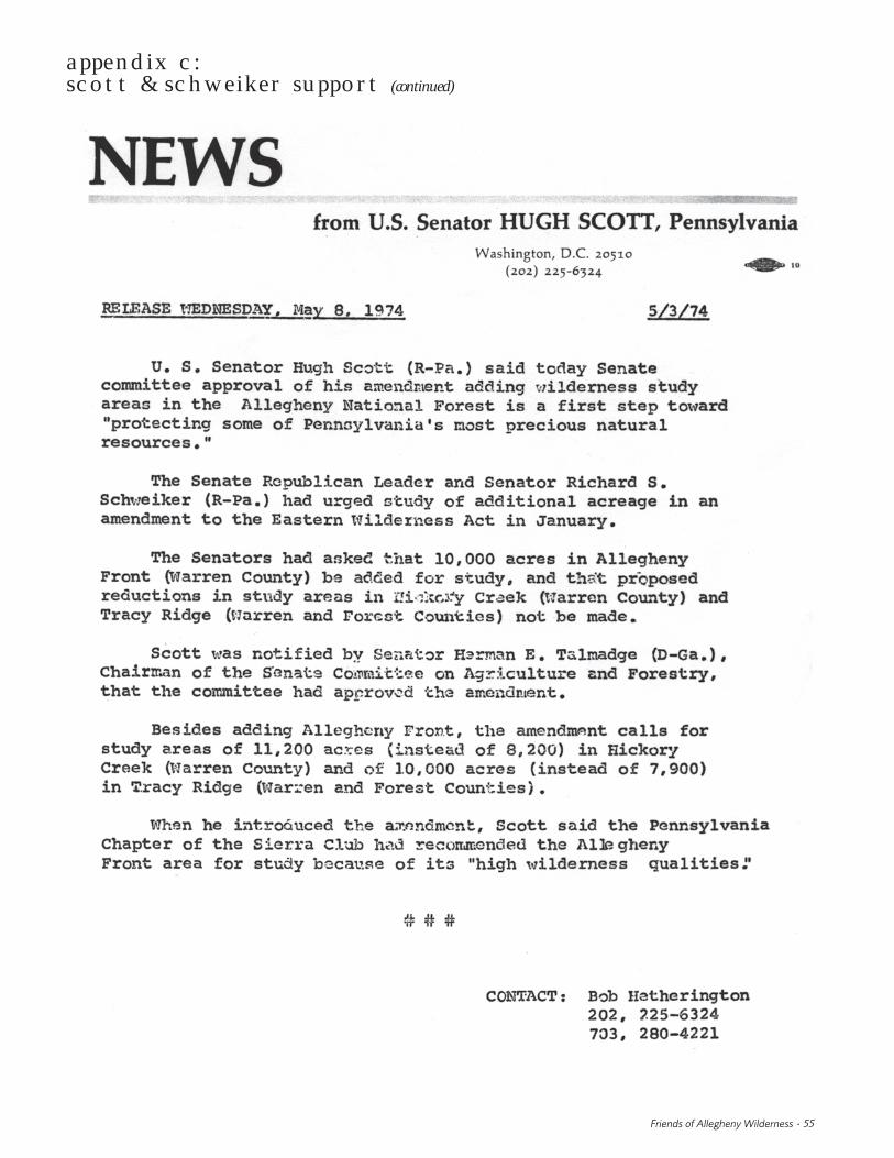
Friends of Allegheny Wilderness • 55
appendix c:scott & schweiker support (continued)

56 • A Citizens’ Wilderness Proposal for Pennsylvania’s Allegheny National Forest
appendix c:scott & schweiker support (continued)

Friends of Allegheny Wilderness • 57
appendix d:1986 anf forest plan management area legend
Taken from U.S. Forest Service (1986).

58 • A Citizens’ Wilderness Proposal for Pennsylvania’s Allegheny National Forest
appendix e:media coverage

Friends of Allegheny Wilderness • 59
appendix e:media coverage (continued)
Copyright, Pittsburgh Post-Gazette, 2003, all rights reserved. Reprinted with Permission.

60 • A Citizens’ Wilderness Proposal for Pennsylvania’s Allegheny National Forest
appendix e:media coverage (continued)

appendix e:media coverage (continued)
Friends of Allegheny Wilderness • 61

62 • A Citizens’ Wilderness Proposal for Pennsylvania’s Allegheny National Forest
appendix e:media coverage (continued)

Friends of Allegheny Wilderness • 63
2003 production note
This document was first designed & typeset in 2003 by J. ChadwickJohnson (online at www.uninsane.com) using Bembo and FoundrySans typefaces in Philadelphia, Pennsylvania. Printing of the first runwas completed by Triune Color in Cinnaminson, New Jersey.
2008 production note
This second printing was completed by Seneca Printing Express, Inc.,in Franklin, Pennsylvania. Little has been changed from the originaldocument, with the exception of correcting some grammatical andpunctuation errors.
The listed size of, and number of wilderness areas contained within,the National Wilderness Preservation System has been updated toreflect current information as of December 2008 (page eight).
This printing could not have been completed without the extremegenerosity of the Fund for Wild Nature, and an anonymous individualsupporter of Friends of Allegheny Wilderness.