9 subdivision and development 9-1 · 9.4.1.2 controlled activities ... section 9: subdivision and...
TRANSCRIPT

9 Subdivision and Development 9-19.1 Introduction......................................................................................................9-19.2 Subdivision and Development Issues..............................................................9-19.3 Subdivision and Development: Objectives and Policies..................................9-3
9.3.1 Protection of the Environment .......................................................9-39.3.2 Well-being, Health and Safety ......................................................9-49.3.3 Servicing Development .................................................................9-69.3.4 Albany Centre ...............................................................................9-7
9.4 Rules: Site Works and Subdivision..................................................................9-79.4.1 Classification of Activities: Site Works and Subdivision Controls .9-7
9.4.1.1 Permitted Activities ...................................................9-79.4.1.2 Controlled Activities ..................................................9-89.4.1.3 Limited Discretionary Activities .................................9-99.4.1.4 Discretionary Activities ...........................................9-109.4.1.5 Non-Complying activities ........................................9-12
9.4.2 Rule: Public Notification Waived .................................................9-129.4.3 Rules: General Standards for All Site Works and Subdivision
Activities ......................................................................................9-129.4.3.1 Compliance ............................................................9-129.4.3.2 Erosion and Sediment Control ...............................9-129.4.3.3 Building Platforms ..................................................9-139.4.3.4 Site Works in an Overland Flow Path .....................9-14
9.4.4 Rules: Subdivision Standards .....................................................9-149.4.4.1 Access ....................................................................9-149.4.4.2 Existing Buildings to Conform ................................9-149.4.4.3 Staging of Subdivisions ..........................................9-159.4.4.4 Cross Lease, Unit Title, Company Lease ...............9-159.4.4.5 Subdivisions Approved Under Previous District
Plan ........................................................................9-159.4.4.6 Subdivision of Land with Two Zonings ...................9-159.4.4.7 Alteration to Land Covenant Boundaries ................9-169.4.4.8 Building Lines, Road Widening and Service Lanes 9-169.4.4.9 Subdivision or Development of Residential Zoned Land
Where an Esplanade Reserve is Required ............9-169.4.4.10 Subdivision for Public Works or Network Utility
Operations ..............................................................9-169.4.4.11 Standards for the Provision of Utility Services .......9-169.4.4.12 Network Utility Distribution Facilities ......................9-179.4.4.13 Service Easements ................................................9-179.4.4.14 Lighting ...................................................................9-17
9.4.5 Subdivision Standards: Residential Zones .................................9-179.4.5.1 Residential 1 Zone .................................................9-179.4.5.2 Residential 2 Zone .................................................9-189.4.5.3 Residential 3 Zone .................................................9-209.4.5.4 Residential 4 Zones ................................................9-209.4.5.5 Residential 5 Zones ................................................9-219.4.5.6 Residential 6 Zones ................................................9-229.4.5.7 Residential 7 Zone .................................................9-229.4.5.8 Minimum Frontage and Access Requirements ......9-229.4.5.9 Shape Factor ..........................................................9-23

9.4.5.10 Land for Multi-unit Housing or Intensive Housing or Terraced Housing or Multi-Unit Development at 8-12 Rangitira Avenue, Takapuna (Lot 1 and Lot 2 DP 42433 and Lot 1 DP 58391) .............................................. 9-23
9.4.5.11 Structure Plan ........................................................ 9-249.4.6 Subdivision Standards: Urban Expansion Zones ....................... 9-24
9.4.6.1 Residential Expansion Zone .................................. 9-249.4.7 Subdivision Standards: Rural Zones .......................................... 9-24
9.4.7.1 Site Area Requirements: Rural 1 Zone .................. 9-249.4.7.2 Site Area Requirements: Rural 2 Zone .................. 9-259.4.7.3 Site Area Requirements: Rural 3 Zones ................ 9-269.4.7.4 General Subdivision Standards: Rural 4(i) & (ii)
Zones ..................................................................... 9-299.4.7.5 Rural Cluster Development Standards Applying to the
Rural 4(i) Zone ....................................................... 9-329.4.7.6 Minimum Frontage and Access ............................. 9-349.4.7.7 Building Area: All Rural Zones and Residential 2A
Zone ....................................................................... 9-359.4.8 Subdivision Standards: Business Zones .................................... 9-35
9.4.8.1 Local 1 and Suburban 2 Zones .............................. 9-359.4.8.2 Takapuna Sub-Regional 3, Albany Sub-Regional 4, 5,
and 6 Zones ........................................................... 9-359.4.8.3 Business Park 7 Zone ............................................ 9-369.4.8.4 Business Special 8 Zone ....................................... 9-369.4.8.5 Business General 9 Zone ...................................... 9-379.4.8.6 Business General 10 Zone .................................... 9-379.4.8.7 Albany Sub-Regional 11 Zone (Business 11 Zone) 9-389.4.8.8 Special Purpose: Chelsea Heritage and Conservation
Future Use Zone .................................................... 9-399.4.9 Subdivision Standards: Special Purpose Zones ......................... 9-39
9.4.9.1 Special Purpose Zone 1: Health ............................ 9-399.4.9.2 Special Purpose Zone 2: Education ....................... 9-399.4.9.3 Special Purpose Zone 3: Wastewater Treatment
Plant ....................................................................... 9-399.4.9.4 Special Purpose Zone 4: Cemetery and
Crematorium ........................................................... 9-399.4.9.5 Special Purpose Zone 5: Transitional Quarry ........ 9-409.4.9.6 Special Purpose Zone 6: Boat Building ................. 9-409.4.9.7 (deleted) ................................................................. 9-409.4.9.8 Special Purpose Zone 8: Awataha Marae ............. 9-409.4.9.9 Special Purpose Zone 9: Community Uses ........... 9-409.4.9.10 Special Purpose Zone 10: Centrepoint Community
Growth Trust .......................................................... 9-409.4.9.11 Special Purpose Zone 11: Albany Centre Amenity Area;
and Special Purpose Zone 12: North Shore Domain and Stadium .................................................................. 9-40
9.4.9.12 Special Purpose Zone 13: Chelsea Sugar Refinery 9-409.4.10 Subdivisions Standards: Albany and Greenhithe Structure Plans
Zone ........................................................................................... 9-409.4.10.1 Compliance ............................................................ 9-409.4.10.2 Roads ..................................................................... 9-419.4.10.3 Pedestrian and Cycle Facilities .............................. 9-419.4.10.4 Pedestrian/Cycle Only Linkages ............................ 9-42

9.4.10.5 Service Roads and Vehicle Access, Egress ..........9-429.4.10.6 On-Street Parking ...................................................9-429.4.10.7 Street Planting & Landscaping ...............................9-439.4.10.8 Neighbourhood Reserves & Roads ........................9-439.4.10.9 Neighbourhood Reserves .......................................9-449.4.10.10 Greenhithe South Structure Plans Zone: Relationship
between Lots for Higher Density Housing and Open Space .....................................................................9-44
9.4.10.11 Area A: Environmental Protection Area/Mixed Environmental ........................................................9-45
9.4.10.12 Area B: Large Lot Residential ................................9-479.4.10.13 Area C: Standard Residential .................................9-499.4.10.14 Areas D: Varied Residential and Mixed Use Overlay
Area ........................................................................9-509.4.10.15 Minimum Site Frontage - Area C, Areas D and Mixed
Use Overlay Area (Rear Sites) ...............................9-519.4.10.16 Shape Factor ..........................................................9-529.4.10.17 No Vehicle Access Frontage ..................................9-529.4.10.18 Mixed Use Overlay Area: Road Reserve Plan .......9-529.4.10.19 Other Relevant Rules - Refer to Section 17A.5 and
17A.6 ......................................................................9-549.5 Rules: Reservations and Restrictions............................................................9-54
9.5.1 Reservations - Matters for Control ..............................................9-549.5.2 Restrictions - Limited Discretionary Activity ................................9-559.5.3 Restrictions - Limited Discretionary Activity - Rural 4(i) & (ii)
Zones ..........................................................................................9-569.6 Rules: Information Requirements ..................................................................9-56
9.6.1 Building Platforms .......................................................................9-569.6.2 Controlled Subdivision ................................................................9-569.6.3 Staging and Subdivisions ............................................................9-579.6.4 Erosion and Sediment Control Plans ..........................................9-579.6.5 Geotechnical and Hydrological Reports ......................................9-589.6.6 Alternative Services ....................................................................9-589.6.7 Subdivision of Land Adjacent to a High Noise Route .................9-599.6.8 Okura Cultural Heritage Survey ..................................................9-59
9.7 Assessment Criteria ......................................................................................9-599.7.1 Controlled Activities ....................................................................9-59
9.7.1.1 General Assessment Criteria .................................9-599.7.1.2 Albany and Greenhithe Structure Plans Zone
Assessment Criteria ...............................................9-649.7.2 Limited Discretionary Activities ...................................................9-68
9.7.2.1 General Assessment Criteria .................................9-689.7.2.2 Site Works on Sites of Geological Significance ......9-689.7.2.3 Subdivision in Residential 1 Zone ..........................9-689.7.2.4 Subdivision in Residential 2A, 2A1, 2B and 2C
Zones .....................................................................9-699.7.2.5 Subdivision in Residential 3 Zone ..........................9-699.7.2.6 Subdivision in Residential 5 Zone ..........................9-699.7.2.7 Subdivision in Residential Zones Involving Control
Flexibility .................................................................9-699.7.2.8 Subdivision Creating Rear Sites in Business 7, 9, 10 and
11 Zones ................................................................9-69

9.7.2.9 Subdivision in the Business Zones Involving Control Flexibility (Landscaping) ........................................ 9-70
9.7.2.10 Subdivision in the Albany and Greenhithe Structure Plans Zone ............................................................. 9-70
9.7.2.11 Subdivision in the Albany and Greenhithe Structure Plans Zone involving Control Flexibility ................. 9-70
9.7.2.12 Compliance with the Albany Centre Structure Plan 9-719.7.2.13 Subdivision in the vicinity of High Voltage Transmission
Lines ...................................................................... 9-719.7.3 Discretionary Activities ............................................................... 9-72
9.7.3.1 General Assessment Criteria ................................. 9-729.7.3.2 Site Works and Subdivision on Land Subject to Natural
Hazards, Significant Landscape Features and Sites of Special Wildlife Interest .......................................... 9-72
9.7.3.3 Subdivision in Areas Beyond the Existing Network Utility Operations ............................................................. 9-73
9.7.3.4 Subdivision of Land Adjacent to a High Noise Route ..................................................................... 9-74
9.7.3.5 Subdivision in the Rural Zones .............................. 9-749.7.3.6 Subdivision in the Okura Rural 4 Zone .................. 9-749.7.3.7 Revegetation - Okura Rural 4 Zone ....................... 9-759.7.3.8 Earthworks - Okura Rural 4 Zone .......................... 9-759.7.3.9 Subdivision in the Albany and Greenhithe Structure
Plans Zone ............................................................. 9-759.7.3.10 Subdivision in the Mixed Use Overlay Area ........... 9-759.7.3.11 Works Within an Overland Flow Path or Flood
Plain ....................................................................... 9-769.7.3.12 Subdivision as a Limited Discretionary or Discretionary
Activity in the 2A Chelsea Special Zone ................ 9-779.7.3.13 Subdivision in the Business 11 zone that does not
provide the local streets shown on the Albany Centre Structure Plan, or does not vest the local streets (public) shown on the Albany Centre Structure Plan .......... 9-78
9.7.3.14 Subdivision as a Discretionary Activity within the Special Purpose: Chelsea Heritage and Conservation Future Use Zone ............................................................... 9-78
9.8 Esplanade Reserves and Strips, and Access Strips ..................................... 9-789.8.1 General Rules ............................................................................. 9-789.8.2 Esplanade Reserves and Strips of a Width Greater than 20
Metres ......................................................................................... 9-799.8.3 Reduction of the Width or Waiver of Esplanade Reserves and Strips
to Less than 20 Metres ............................................................... 9-799.8.4 General Assessment Criteria for Application for Reduction or Waiver
of Esplanade Reserve or Strip Requirement .............................. 9-809.8.5 Access Strips .............................................................................. 9-809.8.6 Replacement of Esplanade Reserves with Esplanade Strips ..... 9-809.8.7 Assessment Criteria for Application to Replace Esplanade Reserves
with Esplanade Strips ................................................................. 9-819.8.8 Minor Boundary Adjustments ..................................................... 9-81

Appendices
9A: Okura Development Envelopes............................................................................... 9-849A: Okura Development Envelopes............................................................................... 9-859A: Okura Development Envelopes............................................................................... 9-869B: Extent of Archaeological Survey ............................................................................. 9-879C: Guidelines for Protection of Areas of Native Bush Practice Note............................ 9-88


Section 9: Subdivision and Development
9. Subdivision and Development
9.1 IntroductionThis section of the Plan is concerned with managing the effects which arise from subdivision and development including site works. Particular sections of the Resource Management Act 1991 (RMA) which are fundamental to the management approach adopted in this Section are as follows:
� Section 5: the sustainable management purpose of the RMA
� Section 6: preserving the natural character of particular features of the environment from inappropriate subdivision and development; the protection of significant indigenous vegetation and habitats
� Section 7: efficient development of resources; amenity values; intrinsic values of ecosystems; the quality of the environment
The Auckland Regional Policy Statement July 1999 contains a number of policies which the Council is required not to be inconsistent with in this section of the Plan. These are as follows:
• Objectives dealing with development which reflect the requirements of Sections 5, 6, 7 and 8 of the RMA
• Objectives aimed at protecting the coastal environment and in particular requiring a precautionary approach to evaluating proposals for subdivision and development in the coastal environment.
The outcomes of this section are particularly relevant to achieving the Objectives and Policies of Sections 8, 15, 16 and 18.Note: For subdivision, siteworks and development in the Long Bay Structure Plan area, refer to Section 17B.
9.2 Subdivision and Development IssuesThe following issues relating to the subdivision of land and the site works necessary for development have been identified and need to be addressed by the Objectives and Policies:
• Loss of vegetation (both native and exotic), resulting in the loss of habitat, amenity values and diversity in the urban landscape
• Increased soil/sediment run-off and changes in hydrology associated with vegetation clearance and earthworks with the consequential adverse effects on amenity values and terrestrial and aquatic ecosystems, and stream health
• Alteration of landforms due to re-contouring, infilling and realignment of waterways (including channelisation), resulting in loss of landscape amenity value, stream health and diversity in the urban environment, and loss of aquatic habitat or loss of ability to regain stream health.
• Where the provision of infrastructure is inadequate or poorly co-ordinated, new development strains or exceeds the capacity and performance of existing infrastructure and has the potential to adversely affect the natural environment and the health and safety of people and communities
• Development contributing to, and/or being significantly affected by, natural hazards such as flooding, subsidence and erosion
• New urban development often fails to recognise the pre-urban landscape, identity and sense of place of particular locations in terms of the combination of vegetation, landform and other elements resulting in the natural patterns of the landscape being blanketed by an often homogeneous form of development, which does not reflect
District Plan June 2002 Updated June 2012 9-1

Section 9: Subdivision and Development
the character and qualities of its original landscape setting.
• Some construction works / techniques, such as slab-on-ground, can increase sediment generation depending on site gradient and result in compaction of soils reducing ability for stormwater infiltration.
Explanation and ReasonsThe identity, amenity values and character of the North Shore derives from both the topography and natural features of the city and its built form. The natural features and quality of the environment are matters highly valued by residents of the city. Of particular importance is the way in which the built form relates to landscape and natural features such as the coastal cliffs and coastline of Birkenhead and East Coast Bays, and the bush-clad escarpments of Kaipatiki, Greenhithe and Paremoremo. The form and character of the city can be expected to reflect changes brought about by further growth and development in terms of both the consolidation of existing development and urban expansion.
With the exception of land in the Albany Basin and on the western and northern fringes of the city, most of the land within the city is already developed for urban purposes. Section 6 of the Plan addresses the form of the city, outlining the Council’s preferred urban growth strategy, while Section 17 deals with the management of future urban expansion in more detail.
More so than any other activity, subdivision and development has the greatest impact on the city’s natural and physical environment. Vegetation clearance and earthworks associated with development are resulting in the modification of landforms and loss of terrestrial and aquatic ecosystems, and reduction in stream health. Protecting the health, resilience and biodiversity of ecosystems and, where practicable, enhancing them is a significant resource management issue. Landscape and natural features can be altered to such an extent that the identity, amenity values and character of an area are lost. These effects are most pronounced for new urban development (residential and business).
It must be recognised that land zoned for urban development will undergo significant and permanent change. Some modification of the natural environment, including vegetation clearance and earthworks, is inevitable in implementing the urban development envisaged by the zoning of the land. In order to achieve a ’livable’ urban environment it is for example, necessary to provide safe and stable building platforms and roads with a suitable gradient. This requires earthworks to a greater or lesser extent, depending upon the characteristics of the land being developed and the approach taken to designing the development.
Some locations, including areas of existing development, are significantly affected by natural hazards such as flooding, subsidence and erosion. The development and further expansion of these areas has the potential to contribute to and/or be significantly affected by such hazards, with consequential loss of property and/or risks to safety.
Inadequate and poorly co-ordinated provision of infrastructure has a number of adverse implications for natural and physical resources, and the community’s economic well-being and health and safety. It can result in inefficient and wasteful use of resources such as land and structures and foreclose future options for the community with regard to land use activities. The question of who should pay for the cost of providing infrastructure and services for newly developing areas involves issues of equity and efficiency of resource use.
The functions of the Council in respect of these issues is determined under Section 31 of the RMA.
Under this section the Council is responsible for controlling subdivision and any actual or potential effects of the use or development of land and associated natural and physical resources, including the avoidance or mitigation of natural hazards.
Under Section 30(1) of the RMA the Auckland Regional Council (ARC) is responsible for controlling the discharge of sediment and other contaminants in terms of maintaining and enhancing water quality. In carrying out this function the ARC has implemented a Proposed Regional Plan - Sediment Control, which aims to limit the adverse effects of sediment discharges on the quality of receiving waters. Under the Proposed Sediment
9-2 Updated June 2012 District Plan June 2002
Section 9: Subdivision and Development
Control Plan a land use consent may be required for vegetation removal, earthworks, roading or quarrying activities - depending upon soil type, area, slope of the site and proximity to watercourses.
North Shore City’s District Plan must not be inconsistent with the Regional Plan - Sediment Control. The maintenance and enhancement of water quality is clearly a Regional Council function and, in addressing sediment run-off effects associated with siteworks, the city Council is concerned with controlling adverse effects on amenity values and habitat in terms of its functions under Section 31 of the RMA.
There is, however, a clear relationship between the physical characteristics of the land, decisions on residential densities at the local level and the potential for surface erosion and greater sediment loadings on receiving waters as the land is converted to urban purposes. The Council’s intervention at the local level will therefore indirectly assist in the promotion of water quality.
With respect to the discharge of stormwater runoff, catchment management plans have been or are being prepared by the North Shore City Council for catchments in the district. These management plans form the basis of comprehensive stormwater discharge consents granted to the City Council by the ARC. The holding of these comprehensive discharge consents empowers the City Council to administer the discharge of stormwater runoff from within the catchments, in accordance with the conditions of the consent and the management plan.
The City Council also has a statutory duty to identify hazard prone areas, and seeks to reduce hazards by the appropriate location of development.
In summary, in terms of its resource management role under the RMA, the Council has a responsibility to ensure that growth and development occurs in a manner that minimises adverse effects on the environment, maintains an appropriate level of amenity values, is integrated with the surrounding development and enables the efficient, environmentally appropriate and cost-effective provision of services.
9.3 Subdivision and Development: Objectives and Policies
9.3.1 Protection of the EnvironmentObjectiveTo avoid, remedy or mitigate the adverse effects of subdivision and development on the environment, including the physical environment, biota, amenity values and landscape.
Policies1. By retaining significant landscape features, vegetation and wildlife habitats, and
riparian margins as they provide amenity value, diversity in the landscape and habitat, and protect stream health.
2. By ensuring that soil/sediment run-off resulting from vegetation clearance and earthworks is managed by on-site control measures in order to avoid or mitigate adverse effects on amenity, stream health, and habitat.
3. By ensuring that new subdivision and development recognises existing natural features and landscapes, such as waterways and that the form of development reflects the character and environmental qualities of the location.
4. By ensuring that new subdivision and development recognises, and is compatible with, the character and amenity values of existing development.
5. By ensuring that subdivision and development is designed and located such that it does not cause or contribute to, and/or be significantly affected by, natural hazards such as flooding, subsidence and erosion.
6. By ensuring the integrated management of resources by requiring that land use and development avoid, remedy or mitigate any adverse effects on natural and physical resources which manifest themselves within or beyond the immediate location and across jurisdictional boundaries.
District Plan June 2002 Updated June 2012 9-3

Section 9: Subdivision and Development
7. By minimising site works on slopes with a gradient exceeding 1:4, and land subject to instability to reduce adverse effects of sediment generation, instability, and erosion.
8. By managing earthworks in relation to their scale, location and timing so as to minimise risks associated with sediment generation, including the risks associated with multiple earthworking areas occurring in the same catchment at the same time.
Methods• Policies 1-4 and Policy 6 will be implemented by Rules
• Policy 2 and 5 will be implemented by Rules and Council engineering standards and also to give effect to the provisions of relevant discharge consents granted by the ARC
• Policies 1-6 will also be implemented through the provision of information on significant aspects of the natural and physical environment and the effects of various subdivision and development practices. Activities that are likely to compromise or damage these features, or contribute to hazards, will be identified along with sustainable practices for avoiding or mitigating such effects.
9.3.2 Well-being, Health and SafetyObjectiveTo ensure that new subdivision and development enables people and communities to provide for their well-being health and safety.
Policies1. By ensuring that the design and construction of subdivision results in the provision
of:
a) Safe and stable building platforms and vehicle access without the need for extensive additional site works.
b) Roads (including footpaths) and privateways with a vertical/horizontal alignment and width that allows the safe and convenient movement of pedestrians, motor vehicles and cyclists.
c) Utility services that have sufficient capacity to absorb the effects of development and maintain human health and safety.
d) Allotments that enable building platforms and other associated activities to achieve adequate separation distances from high voltage transmission lines.
Methods• Policy 1 will be implemented by Rules, including the application of assessment
criteria.
Explanation and ReasonsThe character and identity of North Shore City is drawn, to some extent, from the way in which the built form relates to the topography and natural features of the city. Urbanisation has resulted in substantial modification of topography and natural features. This applies especially in those parts of the city where steep and often difficult topography requires significant earthworks to create lots suitable for the construction of residential dwellings and attendant services such as roading, sewage and stormwater disposal.
Past development practice has resulted in the loss of significant natural landforms and vegetation, and has caused a number of environmental problems at the local level. Apart from continued residential expansion into greenfield areas, much of the growth of the city in recent years has been by way of infill housing. The latter has increased demand on existing services, sometimes in excess of capacity, with consequential adverse effects. The necessary siteworks can also have adverse effects on neighbouring properties.
All development requires some modification of the natural environment, however, in order to allow the establishment of a safe and efficient roading network, infrastructure
9-4 Updated October 2010 District Plan June 2002

Section 9: Subdivision and Development
and building sites. In this regard activities such as vegetation clearance and earthworks are an inevitable part of implementing the Council’s urban growth strategy.
The Council has adopted a ‘minimum impacts’ approach to the identified issues, which does not necessarily imply ‘minimum vegetation clearance’ or ‘minimum earthworks’ in all cases. This approach involves consideration of the effects of development, including those relating to amenity values experienced by occupiers of land following its development. The Objectives and Policies together provide the framework for a strategy of ‘minimum impacts’.
The Council is concerned to ensure that the design of subdivision and subsequent development takes account of any natural or physical constraints. Subdivision and development should take account of inherent characteristics of the site, the availability and capacity of services and the need for earthworks and vegetation clearance to achieve reasonable grades and stable building platforms.
Environmental effects vary according to the type and extent of modification undertaken and the location in which it occurs. There will always be some land that is less suitable for development, in terms of attributes such as quality of existing vegetation cover, presence of natural waterways and wetlands, slope or stability.
Subdivision and development can have adverse effects on significant landscape features, with the potential for a feature to be damaged or destroyed.
Activities such as earthworks have greater or lesser environmental effects depending upon the attributes of the land on which they are undertaken. While earthworks may have significant erosion and sedimentation effects on steep and unstable land, for example, they may have little or no such effects on flatter land (particularly with the use of mitigation measures). Within a particular development it may, therefore be appropriate to avoid extensive earthworks on steeper land but undertake such works on the flatter land. Such an approach in turn has implications for the form and density of development.
Development in the coastal environment may, for example, require greater intervention to control adverse effects in what is a more sensitive receiving environment. The Council is required to recognise and provide for the preservation of the natural character of the coastal environment as a matter of national importance under the RMA.
It is recognised that past practice has been dictated, to some extent, by strict adherence to rigid standards for subdivision design, stipulating such matters as road widths and maximum gradients for roads and other urban services. Changes in technology and construction methods mean that these standards need no longer be absolute, with some flexibility possible in certain circumstances.
The Council seeks to maintain a healthy and vibrant city by enabling development, while at the same time avoiding or mitigating the effects of that development on the environment. Development should not be hindered without good (effects based) reasons when it is otherwise appropriate in terms of what a particular zoning is intended to achieve.
While acknowledging that the development or subdivision of land has many positive effects, the Objective and Policies seek to avoid, remedy and mitigate the associated adverse effects on the environment.
Expected Environmental Results• Protection and enhancement of significant natural features (e.g. landform,
vegetation, waterways, wetlands) and qualities, as measured by indicators specified in the Expected Environmental Results of Section 8: Natural Environment
• Maintenance and enhancement of amenity values, as measured by the Council’s 5-yearly resident survey and more frequent, smaller scale, surveys and monitoring as required
• Reducing the risk of the newly built environment being adversely affected by flooding, erosion and other natural hazards, as measured by regular analysis of the occurrence of hazard events and their impact on the environment
• Increased public awareness of the consequences of development and subdivision on the environment, as measured by regular analysis of the occurrence of hazard
District Plan June 2002 Updated October 2010 9-5
Section 9: Subdivision and Development
events and their impact on the environment
• Increased public awareness of the consequences of development and subdivision on the environment, as measured by Council’s 5-yearly resident survey and more frequent, smaller scale, surveys and monitoring as required
• Subdivision design which is responsive to the sensitivities of the environment in which it is located, as measured by an annual assessment of approved subdivisions.
9.3.3 Servicing DevelopmentObjectiveTo ensure that the servicing of new development is planned and implemented in an efficient manner and such as to avoid or mitigate any adverse environmental effects.
Policies1. By requiring developers to avoid or mitigate the adverse effects of servicing
subdivision and development.
2. By requiring contributions for reserve purposes on the subdivision or development of land.
3. By requiring esplanade reserves on the subdivision or development of land abutting the coast, Lake Pupuke and other qualifying water bodies, or any river or stream of 3 metres or more in width.
4. By requiring the provision of water to, and the disposal of sewage and stormwater from, each lot in a subdivision in a manner and design approved by the Council.
5. By enabling, where appropriate, the provision of alternative means of stormwater and sewage disposal.
6. By requiring the underground reticulation of power and telephone services to each lot in a subdivision wherever practicable.
7. By ensuring provision of the necessary infrastructure in advance of, or concurrent with, any subdivision or building work.
8. By allowing subdivision or development in areas beyond the existing network utility operations provided that an orderly and efficient pattern of development is promoted and the full costs of providing or upgrading the servicing network are met by the developer.
9. By requiring the design of network utility operations to comply with the standards of the relevant network utility operator on subdivision and development.
10. By requiring the installation of utility services on subdivision or development to take account of the need to expand or extend such services to adjacent land in the future to remedy or mitigate any adverse effects on the environment of subsequent subdivision or development.
Methods• Policies 1, 2, 3, 4, 5 and 8 will be implemented by Rules
• Policies 6 and 7 will be implemented partly by Rules and by Council works including amenity improvements/service provision in the Annual Plan
• A Development Contributions regime under the Local Government Act will also be used to fund reserves and infrastructure.
Explanation and ReasonsToday’s residents expect certain services such as roads, power, water supply, stormwater and sewage disposal to be provided at the time of development. It follows, therefore, that the development of the city should be co-ordinated with the provision of utilities and services to ensure that areas for development are capable of being serviced and that the timing of service provision facilitates the development of an area.
The installation of network utility services is specialised and they form part of a network. Other legislation imposes requirements on the technical aspects of supply, and when
9-6 Updated October 2010 District Plan June 2002
Section 9: Subdivision and Development
services are installed they also need to be maintained over a long period of time. For this reason it is important to ensure from the outset that technically appropriate services can be provided, and that they will be compatible with the network to which they will be connected.
The provision of such infrastructure is, however, expensive and requires the use of non-renewable resources. In order to minimise costs it is important that development occurs in a rational and orderly manner. Sections 108 and 220 of the RMA enable conditions to be imposed on resource consents. Such conditions can assist in promoting sustainable management by ensuring that the distribution and form of new development recognises the servicing costs attributable to that development.
Newly developing areas need not only basic servicing but also amenities such as reserves. Where land being subdivided or developed abuts the foreshore and meets the criteria included in Objective 8.3.1 Coastal Conservation, esplanade reserve will also be required.
Expected Environmental Results• Urban development that is serviced efficiently with little or no adverse environmental
effects
• Maintenance and enhancement of public access to the coastline, rivers or streams, as measured by an annual assessment of Council’s records of development and subdivision adjacent to the coast, rivers or streams
• Co-ordination between the expansion of the servicing network and the growth and development of the city, as measured by a biennial assessment of Council’s subdivision records and a biennial assessment of annual plan commitments to the provision of urban infrastructure.
9.3.4 Albany Centre The objectives and policies outlined in Section 15.3.6 shall apply where relevant to subdivision and development within the Albany Centre.
9.4 Rules: Site Works and Subdivision
9.4.1 Classification of Activities: Site Works and Subdivision Controls
The Permitted, Controlled, Limited Discretionary or Discretionary status of site works and subdivision activities is specified in the table below. The Activity status of any activity may be changed by Rules in other Sections of the Plan.
Classification of Activities9.4.1.1 Permitted ActivitiesSubject to compliance with Rule 9.4.3 the following shall be Permitted activities:
a) Site works which expose up to 300m² surface area of bare earth in aggregate over a site at any one time, except where the works are:
i) Within a riparian margin in accordance with Rules 8.4.2.ii) Located less than 5 metres from any cliff face.iii) Situated on land with a gradient of 1:4 or steeper.iv) Would encroach on a Site of Geological Significance identified in the Schedule
in Appendix and shown on the Plan Maps.v) On land comprising a Site of Special Wildlife Interest identified in the Schedule
in Appendix 8A and shown on the Planning Maps.vi) Within the foreshore yard and expose greater than 100m² surface area of bare
earth.b) Site works for underground network utilities located within the road reserve, except
for in the Foreshore Yard. In the Foreshore Yard site works for underground network
District Plan June 2002 Updated June 2012 9-7
Section 9: Subdivision and Development
utilities are permitted only in areas of road reserve under or immediately adjacent to the carriageway, or for which a resource consent has been obtained, or to which existing use rights apply, or which are Permitted activities in accordance with Section 14 - Network Utilities and Designations and the provision of this Plan.
c) Site works for above ground network utilities located in the road reserve for which a resource consent has been obtained, or to which existing use rights apply, or which are Permitted activities in accordance with Section 14 - Network Utilities and Designations and the provisions of this Plan.
d) Site works for the provision, maintenance or repair of roading located in the road reserve.
e) Excavations, except in the foreshore yard, no greater than;
• 1.5 metres in depth, or
• 3 metres in depth for the installation and maintenance of underground network utilities,
as measured by the vertical distance from the top to the bottom of the excavation.
f) Excavations within an approved building platform (not on a boundary or within any yard) greater than 1.5 metres in depth provided that the depth of the excavation in total (measured from the top to the bottom of the excavation) is not greater than the horizontal distance to the site boundary.
g) Excavations in the foreshore yard no greater than 0.5 metres in depth (measured by the vertical distance from the top to the bottom of the excavation).
h) Retaining walls which have the effect of raising the natural ground level by up to 0.5 metres (measured by the vertical distance from the top to the bottom of the wall) located on any boundary or in any yard, except where the retaining wall is in the foreshore yard and is for coastal protection (in accordance with Rule 16.6.1.5A) or where it obstructs an overland flow path (in accordance with Rule 8.4.9.2.4(a)).
i) Retaining walls which have the effect of raising the natural ground level by up to 1.5 metres (measured by the vertical distance from the top to the bottom of the wall) not located on any boundary nor in any yard or within an overland flow path (in accordance with Rule 8.4.9.2.4(a)).
j) Site works authorised by a subdivision consent.
k) Site works that do not alter the configuration of an overland flow path.
9.4.1.2 Controlled Activities Subject to Rule 9.4.1.3 and Rule 9.4.1.4 and compliance with Rule 9.4.3 and Rule 9.4.4 the following shall be Controlled activities:
a) Site works within the foreshore yard for, or associated with, development which is a Controlled activity in accordance with the Plan.
b) Site works within a riparian margin, that do not exceed 10% of the total area of the riparian margin located on the site, and occur within the outer 5 metres of the margin and not within any part of the inner margin, in accordance with Rule 8.4.2.2.
c) Retaining walls which have the effect of raising the natural ground level by more than 0.5 metres and no more than 1.5 metres (measured by the vertical distance from the top to the bottom of the wall) located on any boundary or in any yard, except where the retaining wall is within the foreshore yard or an overland flow path (in accordance with Rule 8.4.9.2.4(a)) or part of any flood plain (in accordance with Rule 8.4.9.1.3 (a)).
d) Subdivision to effect a minor boundary adjustment (as defined in Section 21).
e) Subdivision of land in Residential zones 4 and 6 provided all lots created:
i) Comply with the subdivision standards for the zone in which the subdivision is located, as prescribed in Rule 9.4.5 in this Section.
ii) Can accommodate a structure that complies with the standards and Rules for
9-8 Updated June 2012 District Plan June 2002

Section 9: Subdivision and Development
the zone in which the subdivision is located, as prescribed by Section 16 - Residential.
iii) Shall be able to comply with the parking standards of Section - Transportation.
f) Any subdivision in the Business zones which complies with Rule 9.4.8 except:
i) Subdivision creating rear sites in the Business 7, 9, 10 and 11 zones, and
ii) Subdivision in the Business 7, 8, 9 and 10 zones in which a reduction in the area required to be landscaped in accordance with Rule 15.6.2.8 is sought.
g) Subdivision in the Albany and Greenhithe Structure Plans zone provided for as a Controlled activity in Rule 17A.4.1.
h) Subdivision for network utilities provided that all new lots created and not used for the network utility shall comply with Rule 9.4.5 and Rule 9.4.10 and the network utility is a Permitted activity and/or all necessary resource consents have been granted.
i) Any proposed road in the Albany and Greenhithe Structure Plans Zone complying with a Neighbourhood Unit Plan (Appendix 17A/ A - Appendix 17A/ C).
j) Subdivision of land and buildings, in the Special Purpose: Chelsea Heritage and Conservation Future Use Zone (where this zone has been invoked by the cessation of the refinery activities - refer 20.13A), and where an approved Comprehensive Development Plan and resource consent to establish activities in the Special Purpose: Chelsea Heritage and Conservation Future Use Zone have been granted. Any subdivision application will be processed as non-notified where the land use consent(s) to which it relates has (have) been granted in accordance with an approved Comprehensive Development Plan.
k) Site works associated with flood protection works within the 1% AEP flood plain required to protect existing buildings from flooding hazards.
l) Subdivision in the Residential 8 zone in accordance with Rule 9.4.5.
9.4.1.3 Limited Discretionary ActivitiesSubject to Rule 9.4.1.4 and compliance with Rule 9.4.3 - 9.4.4 and Rule 9.4.7, the following activities shall be Limited Discretionary Activities:
a) Site works within the foreshore yard for, or associated with, development which is a Limited Discretionary activity in accordance with the Plan.
b) Site works within a riparian margin, that exceed 10% of the total area of the riparian margin on a site, and occur within the outer 5 metres of the margin and not within any part of the inner margin, in accordance with Rule 8.4.2.3.
c) Site works within the riparian margin, including where it involves the diversion or modification of part of any Permanent or Intermittent stream, at "56 Fairview" provided that the assessment of the application will also include all that which is stated in 8.4.2 of the Plan and applicable to a Limited Discretionary activity on the subject land.
d) Excavations outside an approved building platform (not on a boundary or within any yard) greater than 1.5 metres in depth provided that the depth of the excavation in total (measured from the top to the bottom of the excavation) is not greater than the horizontal distance to the site boundary.
e) Retaining walls in the foreshore yard which have the effect of raising the natural ground level by more than 0.5 metres and no more than 1.5 metres (measured by the vertical distance from the top to the bottom of the wall) except where the retaining wall is for coastal protection (in accordance with Rule 16.6.1.5A).
f) Excavation (not on a boundary or in any yard) greater than 1.5 metres in depth provided that the depth of the excavation in excess of 1.5 metres (measured from the top to the bottom of the excavation) is not greater than the horizontal distance to a site boundary.
g) Excavations in the foreshore yard greater than 0.5 metres and no more than 1.5 metres in depth (measured by the vertical distance from the top to bottom of the
District Plan June 2002 Updated November 2013 9-9
Section 9: Subdivision and Development
excavation).
h) Site works that encroach on a site of Geological Significance identified in Schedule 8B and shown on the Plan Maps.
i) Site works within the foreshore yard which expose more than 100m² and less than 300m² surface area of bare earth and site works which expose greater than 300m² surface area of bare earth, which are not Discretionary activities in accordance with Rule 9.4.1.4.
j) Site works that alter the configuration of an overland flow path.
k) Site works within the 1% AEP floodplain that is within '56 Fairview"
l) Subdivision in the Residential 1, 2, 3, 5 and 7 zones in accordance with Rule 9.4.5.
m) Subdivision in the Residential zones seeking Reduced Vehicle Access under Rule 9.4.5.8.
n) Subdivision in the Rural 4 (i) zone where the minimum site area is at least 5000 sqm and the average site area is 2 ha or greater
o) Subdivision in the Rural 4(ii) zone, where the minimum site area is at least 4 ha
p) Site works in the Rural 4 zone which expose greater than 300 m2 surface area of bare earth in any 12 month period which are not discretionary activities in accordance with Rule 9.4.1.4
q) Subdivision in the Albany and Greenhithe Structure Plans zone proposing an intersection not in accordance with Rule 9.4.10.2.1: Intersections.
r) Subdivision in the Albany and Greenhithe Structure Plans zone not in accordance with Rule 9.4.10.3: Pedestrian and Cycle Facilities.
s) Subdivision in the Albany and Greenhithe Structure Plans zone not in accordance with Rule 9.4.10.4: Pedestrian and Cycle Only Linkages.
t) Subdivision in the Albany and Greenhithe Structure Plans zone not complying with Rule 9.4.10.5: Service Roads and Vehicle Access/Egress.
u) Subdivision in the Albany and Greenhithe Structure Plans zone not complying with Rule 9.4.10.6: On-Street Parking.
v) Subdivision in the Albany and Greenhithe Structure Plans zone not complying with Rule 9.4.10.7: Street Planting and Landscaping.
w) Subdivision in the Albany and Greenhithe Structure Plans zone proposing public open space not complying with Rule 9.4.10.8: Neighbourhood Reserves and Roads.
x) Subdivision in the Albany and Greenhithe Structure Plans zone not complying with Rule 9.4.10.9: Neighbourhood Reserves.
y) Subdivision in the Greenhithe Structure Plans zone proposing a street network not complying with Rule 9.4.10.10: Relationship between lots for Higher Density Housing and Open Space.
z) Subdivision in the 2A Chelsea Special zone that is demarcated within, and in accordance with, an 'approved integrated development scheme’.
aa) Subdivision creating an allotment that lies within 25 metres of high voltage transmission lines, as measured from the centreline at ground level.
ab) Siteworks and subdivision within the Milford Intensive Residential DevelopmentOverlay Area.
9.4.1.4 Discretionary ActivitiesSubject to Rule 9.4.3, 9.4.4 and Rule 9.4.7, the following activities shall be Discretionary Activities:
a) Site works within the foreshore yard for or associated with development which is a Discretionary activity in accordance with the Plan.
9-10 Updated December 2014 District Plan June 2002
Section 9: Subdivision and Development
b) Site works within a riparian margin that are not a Permitted, Controlled or Limited Discretionary activity, or associated with diversion or modification of a waterway, in accordance with Rule 8.4.2.4.
c) Site works:
i) Located less than 5 metres from any cliff face.
ii) On land comprising a Site of Special Wildlife Interest identified in the Schedule in Appendix 8A and shown on the Plan Maps.
iii) Within the 1% AEP flood plain, and not within "56 Fairview", where they are not associated with flood protection works required to protect existing buildings from flooding hazards, or network utilities.
iv) Within the foreshore yard which expose more than 300m² surface area of bare earth.
d) Retaining walls in the foreshore yard which have the effect of raising the natural ground level by more than 1.5 metres (measured by the vertical distance from the top to the bottom of the wall) or where the retaining wall is for coastal protection (in accordance with Rule 16.6.1.5A).
e) Excavation in the foreshore yard greater than 1.5 metres in depth (measured by the vertical distance from the top to bottom of the excavation).
f) Site works not otherwise provided for as a Permitted, Controlled, Limited Discretionary or Non-Complying activity.
g) Subdivision requiring the provision of alternative servicing systems.
h) Subdivision on land adjacent to High Noise Routes shown in Appendix 10D.
i) Site works on or subdivision of land comprising a significant landscape feature as identified in the District Plan Maps, but excluding 55 Lonely Track Road, Lot 2 DP 95896 & Lot 2 DP 341647, the subdivision of which and any associated site work, including works associated with the installation of infrastructure services, shall be a Controlled Activity.
j) Subdivision in the Albany and Greenhithe Structure Plans zone provided for in Rule 17A.4.1
k) Rural Cluster development in the Rural 4(i) zone in accordance with Rule 9.4.7.5
l) Land disturbance exceeding 1900 sqm per lot in the Rural 4 zone.
m) Site works or subdivision where the subject land has an average gradient steeper than 1:4
n) Subdivision which will result in no suitable building platform being available outside the overland flow path.
o) Subdivision that will result in a building platform within the 1% AEP flood plain (in accordance with Rule 8.4.9.1.3 (a)).
p) Subdivision in the 2A Chelsea Special zone -
i) involving any form of vehicular access from Onetaunga Road; or
ii) any part of which would involve earthworks or vegetation clearance in a Site of Special Wildlife Interest or in the Coastal Conservation Area or within 20 metres of a water body, watercourse or the Special Purpose 13 zone "Land Area" (sludge disposal area);
provided that subdivision in accordance with an 'approved integrated development scheme' shall be a Limited Discretionary activity.
q) Subdivision in the Business 11 zone that does not provide the local streets shown on the Albany Centre Structure Plan contained as an Appendix to the Plan Maps.
r) Subdivison in the Business 11 zone that does not vest the local streets (public) shown on the Albany Centre Structure Plan contained as an Appendix to the Plan
District Plan June 2002 Updated November 2013 9-11
Section 9: Subdivision and Development
Maps.
s) Subdivision of land and buildings in the Special Purpose: Chelsea Heritage and Conservation Future Use Zone (where this zone has been invoked by the cessation of the refinery activities - refer 20.13A) other than in compliance with Rule 9.4.1.2(i), subject to the provisions of section 9.4 and in particular section 9.4.8.8 and excluding Rule 9.4.10. Any such application will be publicly notified.
Notes: The District Plan Maps should be checked and reference made to the relevant Sections of the District Plan as notations on the District Plan Maps may require. The Objectives and Policies contained in Section 17A need also be referred to in the case of subdivision in a Structure Plan zone.
9.4.1.5 Non-Complying activitiesSite works within the foreshore yard for, or associated with, development which is a Non-Complying activity in accordance with the Plan.
9.4.2 Rule: Public Notification WaivedThe Council shall consider any application for the following Limited Discretionary resource consents under Rule 9.4.1.3(b) and (d) without public notification. Notice of such an application shall be served on all affected parties unless the statutory tests for non-notification are met. If the Council considers special circumstances exist it may require the application to be publicly notified.a) Excavations outside an approved building platform (not on a boundary or within any
yard) greater than 1.5 metres in depth provided that the depth of the excavation in total (measured from the top to the bottom of the excavation) is not greater than the horizontal distance to the site boundary.
b) Excavation (not on a boundary or in any yard) greater than 1.5 metres in depth provided that the depth of the excavation in excess of 1.5 metres (measured from the top to the bottom of the excavation) is not greater than the horizontal distance to a site boundary.Refer to Rule 3.3.2 Notificatiion Processes for Resource Consents - Applications Requiring Multiple Resource Consents
9.4.2ARule: Public Notification and Serving Notice WaivedThe Council shall consider any Limited Discretionary application for site works which expose greater than 300m² surface area of bare earth under Rule 9.4.1.3(g), which are not Discretionary activities in accordance with Rule 9.4.1.4, without public notification or the need to obtain the written approval of, or serve notice on affected parties. If the Council considers special circumstances exist it may require the application to be publicly notified.Refer to Rule 3.3.2 Notificatiion Processes for Resource Consents - Applications Requiring Multiple Resource Consents.
9.4.3 Rules: General Standards for All Site Works and Subdivision Activities
9.4.3.1 ComplianceNo person shall commence any site works or the clearance or stripping of vegetation which exposes bare earth, except where such activities are permitted by this Plan, or a resource consent has been obtained.Explanation and ReasonsThe Council is charged with promoting the sustainable management of natural and physical resources and to, among other things, manage the use, development and protection of such resources in a way that avoids, remedies or mitigates any adverse effects of activities on the environment. These rules seek to ensure that all relevant matters are considered.
9.4.3.2 Erosion and Sediment Controla) All site works and subdivision shall be undertaken with the application and
9-12 Updated June 2011 District Plan June 2002
Section 9: Subdivision and Development
maintenance of recognised methods and techniques for the retention of sediment on site and the prevention of discharges of sediment off-site or into stormwater systems.
b) All site works and subdivision shall be undertaken with the application of runoff control measures isolating the site works and related activities from the surrounding land and preventing flows of stormwater into, across or escaping the area being worked.
c) Vehicle movements to and from the site or location where site works and subdivision activities are being undertaken shall not result in any material being deposited on a public road creating a hazard or a nuisance to road users.
d) An Erosion and Sediment Control Plan shall be prepared in accordance with Rule 9.6.4 for all site works and subdivision activities.
e) Erosion and sediment control measures shall be in place prior to any earthworks commencing. In the event that earthworks are staged, the relevant controls shall be in place prior to commencement of each stage.
f) Erosion and sediment control measures shall be retained and maintained in good working order until all works have been completed and the site secured to prevent erosion and the generation and discharge of any further sediment from the site.
Explanation and ReasonsThe rules seek to ensure that the environmental effects of stormwater runoff from earthworked land is minimised by the use of techniques appropriate to the circumstances and scale of operation.
The rules seek to promote the use of an integrated approach to site works and subdivision wherever practicable. It is recognised that an integrated approach, which may include low impact design, will result in the range of issues that affect stormwater management being considered through the site development process.
The prevention of erosion and control of sediment is a key objective for the protection of the receiving environment in North Shore City, including lakes, streams, marine reserves, the upper Waitemata Harbour, and coastal areas. This rule establishes the requirement for Erosion and Sediment Control Plans to be prepared for all site works and subdivision activities and provides standards to ensure effective erosion and sediment control measures are retained for the full duration of site works and subdivision activities.Note:Acceptable methods or techniques, as appropriate in the circumstances, are provided in publications by the Council or the Regional Council. Correctly applied and maintained, such methods or techniques constitute the ’best practicable option’. The rule requires their application to all site works and subdivision activities irrespective of whether they are classified as permitted, controlled or discretionary. The granting of a land use consent for earthworks shall not in any way limit or restrict the Council’s ability to impose conditions in respect of any subsequent application for subdivision consent.
The objectives for Stormwater Management (8.3.5) should also be referred to in relation to this rule.
9.4.3.3 Building Platformsa) The location of the building platform shall:
i) Be located outside the 1% AEP flood plain and any overland flow path. For the avoidance of doubt, this provision does not apply to network utilities: And
ii) Provide a minimum of 500mm freeboard above the 1% AEP flood level if for a habitable residential building in the coastal inundation area or flood sensitive area; and
iii) Ensure finished floor levels for buildings other than habitable residential buildings are above the 1% AEP flood level in the coastal inundation area or flood sensitive areas; and
iv) Ensure that subsequent permitted development could comply with yard, access, arterial setbacks, building line restrictions, NZECP 34:2001; and
v) Be identified on a subdivision plan if required to be located in the 1% AEP or an overland flow path, and all buildings shall be located entirely within the
District Plan June 2002 Updated June 2012 9-13

Section 9: Subdivision and Development
building platform.
b) For the purposes of Rule 9.6.1 a suitable platform shall:
i) Meet the standards of 9.4.3.3(a); and
ii) Have regard to the adopted NSCC engineering/infrastructure standards as then current; and
iii) Comply with the specific foundation design requirements determined by a registered engineer experienced in soil mechanics (or similarly qualified and experienced person).
Explanation and ReasonsThe need to identify an area suitable for the construction of a building on each lot ensures that the design of the subdivision or development takes account of the particular characteristics of the land in the layout of the lots and location of buildings to avoid potential risks to property and safety from natural hazards. It also enables the Council to be satisfied that a suitable building area can be provided, in accordance with the requirements of the zone in which the land is located, prior to any approval of the subdivision.The location of building platforms in the 1% AEP flood plain or an overland flow path creates problems for the property owner (including adverse effects on amenity values, and potential risks to property and safety), downstream properties and receiving environments by increasing and/or redirecting flood flows and preventing the flood plain from functioning naturally, and therefore all effort to prevent buildings locating in the flood plain or obstructing overland flow paths should be taken. It is expected that in determining an appropriate building platform consideration be given to any current adopted NSCC engineering/infrastructure standards.Note: Buildings in riparian margins are addressed by Rule 8.4.2 Protection of Habitat and Streams.
9.4.3.4 Site Works in an Overland Flow PathSite works that do not alter the configuration of an overland flow path (Rule 9.4.1.1 k)) are works that maintain the same route of the overland flow path, maintain the same entry and exit point at the site boundary, and do not alter the volume and velocity of water flow.
Explanation and ReasonsSite works are permitted activities in an overland flow path provided they do not alter the configuration of the overland flow path according to the criteria detailed above.
9.4.4 Rules: Subdivision Standards9.4.4.1 Accessa) Every lot shall be provided with legal access in terms of Section 321 of the Local
Government Act 1974; except that every lot, other than allotments created through road closure or severance, shall be provided with a safe physical and practical access to a formed legal road which is maintained to Council standards.
b) The design and construction of rights of way, private roads and privateways shall comply with the requirements of the zone in which they are located. Where access to a State Highway is to be formed, the location, design and construction of the access shall also comply with the requirements of Transit New Zealand.
Explanation and ReasonsThis rule seeks to ensure that all sites have safe and practical vehicular access to formed legal roads.
9.4.4.2 Existing Buildings to ConformUnless authorised by Section 10 of the RMA, or otherwise authorised by a resource consent, subdivision shall not result in any existing buildings, which are located on land proposed to be subdivided, ceasing to comply with the development controls and parking requirements of the zone in relation to the new boundaries created.
9-14 Updated June 2012 District Plan June 2002

Section 9: Subdivision and Development
Explanation and ReasonsAll activities are required to comply with the provisions of the Plan or with a resource consent, unless existing use rights apply under Section 10 of the RMA. New development should not therefore be permitted to render an existing activity non-complying unless authorised by a resource consent.
9.4.4.3 Staging of SubdivisionsApproval in terms of Section 224 of the RMA for each stage will only be given when the Council is satisfied with the conditions which apply to that stage have been met and the balance of the area being subdivided is an allotment which complies with the provisions of this Plan.
9.4.4.4 Cross Lease, Unit Title, Company LeaseAll buildings subject to a cross lease, unit title or company lease application must have:
a) Existing use rights.b) Comply with the relevant provisions of the Plan.c) A resource consent.Where any building fails to comply with (a), (b) or (c) above, an application for a subdivision consent may be deferred under Section 91 of the RMA until an application is received for the land use consent in accordance with the relevant rules of the zone in which the land is located.
9.4.4.5 Subdivisions Approved Under Previous District PlanWhere a site has been created by subdivision in a residential zone, prior to the notification of this Plan, the minimum net site area, minimum lot size and/or density requirements of this Plan shall not of themselves prevent the granting of a resource consent to the erection of a single dwelling on the site provided:
a) The subdivision was lawful and complied with the subdivision rules of the previous District Plan that was operative at the time the survey plan was approved, and
b) The site is vacant land not having been built upon since subdivision.
Explanation and ReasonsThis provision seeks to ensure that the existing use rights pertaining to vacant lots created by an earlier subdivision are not frustrated by the subsequent introduction of density rules in specific circumstances.
9.4.4.6 Subdivision of Land with Two ZoningsWhen any land which has more than one zoning is subdivided, the lot boundaries of the subdivision shall follow the zone boundary and the lots created shall comply with the provisions of the particular zone in which the lots are located or the subdivision shall become a Non-Complying activity provided that where the subdivision involves the acquisition of other land for a minor boundary adjustment as defined in Section 21 andthat other land is of a different zone, the subdivision shall be considered as a Limited Discretionary activity. Notwithstanding the above rule, the subdivision of 55 Lonely Track Road, Lot 2 DP 95896 & Lot DP 341647 shall be a Controlled Activity.
Explanation and ReasonsThe rules for subdivision in any zone have been imposed on the basis of the characteristics of the land and the likely effects of the activities permitted by the zone. In resource management terms, therefore, it is important that any subdivision takes account of the zone boundary.
Every endeavour has been made to ensure that zone boundaries follow legal boundaries. For various reasons, however, these boundaries may be shown to be inappropriate or impractical, particularly where comprehensive development of a large area of land is proposed.
District Plan June 2002 Updated November 2013 9-15
Section 9: Subdivision and Development
9.4.4.7 Alteration to Land Covenant Boundariesa) Alterations to land covenant boundaries shall not contravene the conditions of a
subdivision consent to which the associated unit, or structure is subject.b) A land use resource consent, in accordance with the relevant rules of the zone in
which the land is located, shall be obtained for alterations to a land covenant boundary which would result in non-compliance with Rule 16.6.2.2, Delineated Area.
Explanation and ReasonsSubdivision consent for any cross lease is given on the basis that, among other things, the proposal complies with the rules of the Plan. This rule seeks to ensure that any alteration to covenant boundaries does not compromise that compliance and so render an existing activity non-complying.
9.4.4.8 Building Lines, Road Widening and Service LanesWhere a building line restriction for road widening purposes is shown in the District Plan the Council will, or where a proposed service lane is shown on the District Plan the Council may, (as a condition of any subdivision consent or building activity), require:
a) The vesting of the land between that building line and the existing road frontage in the Council for road purposes, or
b) The land comprising the proposed service lane to vest in the Council.
Explanation and ReasonsThe indication of a proposed service lane or a building line for road widening purposes in the Plan indicates the Council’s future requirements for traffic management purposes. The rules identify the stage at which the Council will generally acquire the relevant land.
9.4.4.9 Subdivision or Development of Residential Zoned Land Where an Esplanade Reserve is Required
Where the site to be subdivided or developed has an area of 2000m² or less, the provisions of Rule 16.6.1.5 shall apply.
9.4.4.10 Subdivision for Public Works or Network Utility Operations
The provisions of the subdivisional requirements relating to a particular zone shall not apply to any sites created for the purposes of a public work or network utility, within the meaning of the RMA.
Explanation and ReasonsThis Rule recognises that the subdivision requirements of the Plan may not always be appropriate for the purposes of public works or network utilities.
9.4.4.11 Standards for the Provision of Utility ServicesEach site shall be provided with the network utilities appropriate to the proposed use of the site such that:
a) Roads shall have a design life of at least 25 years.b) Water, stormwater and sewage systems shall have a design life of at least 50 years
and utilise gravity wherever possible.c) Reasonable and safe access for maintenance is provided.d) Legislation and industry standards to which the utility is subject are complied with.e) Their design, materials and constructions safeguard against harm to people or
property, and compromises of public health standards.f) Their design, materials and construction meet the demand/load/flow/pressure
created by the proposed subdivision and resulting development, to the extent anticipated by the District Plan in addition to servicing existing connections.
g) The integrity of the system to which the utility is connected is protected.
h) Stormwater systems for land use activities, which have the potential to discharge
9-16 Updated October 2011 District Plan June 2002

Section 9: Subdivision and Development
significant stormwater contaminant, shall prevent uncontaminated stormwater from coming into contact with contaminants or, where not practicable, pre-treat site specific contaminants before disposal.
Note:1. NSCC maintains the Infrastructure Design Standards Manual, which should be referred to when
considering the requirements of Rule 9.4.4.12.2. The Long Bay Structure Plan Practice Notes should be referred to when considering subdivision
siteworks and development in the Long Bay Structure Plan area.
Explanation and ReasonsThese standards recognise that the provision of network utilities is essential to modern lifestyles. The provision of such services at an early stage in the development of land should lead to a more cost effective and efficient use of resources and reduce any adverse effects on the environment.
In relation to stormwater, all land uses have an impact on stormwater quantity and quality, and the design of stormwater systems needs to recognise this. Many land uses however have the potential to create significant adverse effects, including business, industrial and car parking.
9.4.4.12 Network Utility Distribution FacilitiesWhere at any frontage of any lot, an area of land on which to locate an electricity distribution station or a gas regulator station is required, the road boundary may be required to be set back to incorporate the site of the substation or station.
On any site abutting such a substation or station, the development control rules shall be applied to the site as though the road boundary had not been set back, and the minimum site dimensions and area specified in this Plan may be reduced by amounts not exceeding the dimensions and area of the additional land vested as road for the substation or station.
The maximum area reduction applicable under this provision shall not exceed 20m² on any lot.
Explanation and ReasonsThis Rule recognises the need to provide for facilities for network utility distribution, but seeks to ensure that the development potential of the site on which such facilities are located is not affected.
9.4.4.13 Service EasementsWherever necessary to ensure continued access to network utility services which are to be owned by the network utility operator and which are located outside of roads vested or to be vested in the Council, appropriate easements must be granted by the subdivider in favour of the network utility operator at the cost of the subdivider.
9.4.4.14 LightingThe design and provision of lighting in roads and public places must:
a) Be located so as to illuminate public accessways and pathways (for their full length), reserve entrances and road or private way intersections, and
b) Comply with AS/NZS 1158:1997 and its successors.
9.4.5 Subdivision Standards: Residential Zones9.4.5.1 Residential 1 Zonea) Site Area Requirements
• Sewered Sites
Minimum Net Site Area 1200m²
Average Area 1500m²; provided that sites with an area in excess of 1800m² shall not be considered when calculating average area.
District Plan June 2002 Updated October 2010 9-17

Section 9: Subdivision and Development
• Non Sewered Sites
b) Minimum Frontage
• Sewered Sites
• Non Sewered Sites
c) Shape Factor
See Rule 9.4.5.9.
9.4.5.2 Residential 2 Zonea) Site Area Requirements
• Residential 2A zone
ii) The required minimum site area may be comprised as follows:
• Totally within each proposed lot on a Plan of Subdivision; or
• Partially within a lot which contains the complying building area as defined in Rule 9.4.7.7 and which is held together with an undivided share in a common lot or lots which are used for landscape conservation or reserves. Provided that a subdivision in terms of this part of the rule shall comply with the following criteria:
a) The lot containing the complying building area shall have a minimum area of 400m² and shall, in its pre-subdivision state, be predominantly clear of native trees and bush.
b) Where a common lot is proposed for landscape conservation, it shall be located immediately adjacent to (and contiguous with) the lot containing the building area, and shall be protected by a QEII National Trust Open Space Covenant, or Covenant under the Reserves Act 1977 or by alternative means to ensure the long term protection of the bush or natural features within the site. A guideline as to the matters that will be considered by the Council when assessing the suitability of native bush for protection by way of a covenant is contained in Appendix 9C. An agreement to covenant must be entered into before the issue of the Section 224(c) Completion Certificate under the RMA.
c) As an alternative to the creation of a common lot for landscape conservation, the common lot area may be vested as public reserve under the Reserves Act 1977, provided that in all other respects the subdivision shall comply with the provisions of clauses (a), (b) and (d) of this part of
Minimum Net Site Area 4000m²
Front Sites 24m; provided that this may be reduced to 10 metres where the side boundaries of the site diverge from the road and the width of the site is not less than 20m at a depth of 10m from the road frontage.
Rear Sites See Rule 9.4.5.8.
Front Sites 48m
Rear Sites See Rule 9.4.5.8.
i) Minimum Net Site Area 1000m² gross site area, 800m² net site area, provided that it is expected that on those sites containing good quality native bush or bush which is of ecological significance, larger sites will be provided in order to maintain natural values.
9-18 Updated October 2010 District Plan June 2002

Section 9: Subdivision and Development
this rule.
d) The number of lots on which a dwelling may be sited shall not exceed one for every 1000m² of the total area of land in the subdivision.
• Residential 2A1 Zone
• Residential 2B Zone
• Residential 2C Zone
b) Minimum Frontage Requirements
• Residential 2A and 2A1 Zones
• Residential 2B Zone
• Residential 2C Zone
c) Shape Factor
See Rule 9.4.5.9.
d) Terraced Housing or Multi-Unit Development at 8-12 Rangitira Avenue, Takapuna (Lot 1 and Lot 2 DP 42433 and Lot 1 DP 58391)
See Rule 9.4.5.10.
Minimum Net Site Area 5000m²
Minimum Net Site Area 600m²
Minimum Net Site Area 350m²
Front Sites 24m; provided that this may be reduced to 10m where the side boundaries of the site diverge from the road and the width of the site is not less than 20m at a depth of 10m from the road frontage.
Corner Sites 48m
Rear Sites See Rule 9.4.5.8
Front Sites 16.5m; provided that this may be reduced to 10m where the side boundaries of the site diverge from the road and the width of the site is not less than 20m at a depth of 10m from the road frontage
Corner Sites 33m
Rear Sites See Rule 9.4.5.8.
Front Sites 13m; provided that this may be reduced to 10m where the side boundaries of the site diverge from the road and the width of the site is not less than 20m at a depth of 10m from the road frontage
Corner Sites 26m
Rear Sites See Rule 9.4.5.8.
District Plan June 2002 Updated October 2010 9-19

Section 9: Subdivision and Development
9.4.5.3 Residential 3 Zonea) Site Area Requirements
• Residential 3A Zone
Except, the following minimum net site area shall apply to applications for resource and building consent lodged with the Council prior to 6 April 2006 or any residential unit lawfully established prior to 6 April 2006 - 400m2
• Residential 3B Zone
• Residential 3C Zone
b) Minimum Frontage Requirements
Residential 3A, 3B and 3C zones
c) Shape Factor
See Rule 9.4.5.9.
d) Terraced Housing
See Rule 9.4.5.10.
9.4.5.4 Residential 4 Zonesa) Site Area Requirements
• Residential 4A Zone
• Residential 4B Zone
Except, the following minimum net site areas shall apply where the site area requirements above are more restrictive to applications for resource consent and/or building consent lodged with the council prior to 6 April 2006, or any residential unit
Minimum Net Site Area 450m²
Minimum Net Site Area 500m²
Minimum Net Site Area 600m²
Front Sites 12m
Corner Sites 24m
Rear Sites See Rule 9.4.5.8
Minimum Net Site Area 450m²; or greater; or
400m2 or greater for up to 5 units as a controlled activity; or
An average of 350m2 or greater for more than 5 units as a limited discretionary activity
Minimum Net Site Area 450m²; or greater; or
400m2 or greater for 3-5 units as a controlled activity; or
An average of 400m2 or greater for more than 5 units as a limited discretionary activity.
9-20 Updated October 2010 District Plan June 2002

Section 9: Subdivision and Development
lawfully established between Oct 1994 and 6 April 2006, or to any land use or development proposal that was partially completed prior to 6 April 2006.
Residential 4A zone - 350m2
Residential 4B zone - 400m2
Public Notification and Serving Notice WaivedThe Council shall consider any Limited Discretionary application for "Residential Units, more than 5 per site", with an average site area of at least 350m2 per unit in the Residential 4A zone and an average site area of at least 400m2 per unit in the Residential 4B zone, without public notification or the need to obtain the written approval of, or serve notice on affected parties. If the Council considers special circumstances esist, it may require the application to be publicly notified.
Refer to Rule 3.3.2 Notification Processes for Resource Consents.
b) Minimum Frontage Requirements
See Rule 9.4.5.8.
c) Shape Factor
See Rule 9.4.5.9.
d) Multi-unit Housing or Intensive Housing or Terraced Housing
See Rule 9.4.5.10.
9.4.5.5 Residential 5 Zonesa) Ability to Subdivide
Any allotment to be subdivided shall have a net area not less than 1500m², unless the land concerned has been clearly set aside on a previous subdivision consent as a second stage subdivision.
b) Site Area Requirement
Minimum Net Site Area -
• Lots shall range from 350m² as follows:
• Wherever practical, a wide range of lots should be provided in each subdivision. However, the most important factor determining lot size and layout is that they must relate directly to the environmental characteristics of the land as identified in the information required by Rule 3.10.7 to Rule 3.10.9 to be submitted in conjunction with the Plan of Subdivision. On land with few environmental limitations, it is expected that the greatest proportion (70%-80%) of lots will be between 350m² and 700m² in net area. On steeper land, or land containing native trees and bush, lot sizes should be larger (700m²-1000m² net area and above). On those sites or parts of sites which are flatter and clear of trees, lot sizes may be smaller (550m² and less)
• For any mixed density subdivision approved under this rule, the Council will impose either a covenant or a consent notice under Section 221 of the RMA registerable on the certificate of title of any lots exceeding 350m² minimum net site area, to the effect that any further subdivision of that lot (other than a minor boundary adjustment) is prohibited unless the land concerned has been clearly set aside on the previous application as a second stage subdivision.
c) Minimum Frontage Requirements
See Rule 9.4.5.8.
d) Shape Factor
See Rule 9.4.5.9.
e) Multi-unit Housing or Intensive Housing or Terraced Housing
See Rule 9.4.5.10.
District Plan June 2002 Updated October 2010 9-21

Section 9: Subdivision and Development
9.4.5.6 Residential 6 Zonesa) Site Area Requirements
• Residential 6A Zone
• Residential 6B Zone
• Residential 6C Zone
b) Minimum Frontage Requirements
See Rule 9.4.5.8.
c) Shape Factor
See Rule 9.4.5.9.
d) Multi-unit Housing or Intensive Housing or Terraced Housing
See Rule 9.4.5.10.
9.4.5.7 Residential 7 Zonea) Site Area Requirements
9.4.5.7A Residential 8 Zonea) Site Area Requirements
b) Unit Title Subdivision
9.4.5.8 Minimum Frontage and Access RequirementsAll sites in the Residential 3, 4, 5, 6 and 7 zones, and rear sites in the Residential 1 and 2 zones shall comply with the following:
a) Each site shall have or share a frontage or right of way to a public road by means of;- a single entrance strip- an entrance strip with an easement or easements of right of way granted over
land adjoining the entrance strip
Minimum Net Site Area 450m²; or
350m² where the associated residential unit has been granted a resource consent.
Minimum Area 450m²; or
400m² where the associated residential unit has been granted a resource consent.
Minimum Area 450m²; or
250m² where the associated residential unit has been granted a resource consent.
Minimum Net Site Area 450m²; or
200m² where the associated residential unit has been granted a resource consent.
Minimum Net Site Area 450m²
Unit title subdivision of residential and commercial units
Unit title subdivision of residential and commercial units in accordance with an approved development that has been granted consent under Rule 16.8.
9-22 Updated November 2013 District Plan June 2002
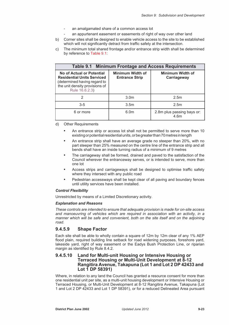
Section 9: Subdivision and Development
- an amalgamated share of a common access lot- an appurtenant easement or easements of right of way over other land
b) Corner sites shall be designed to enable vehicle access to the site to be established which will not significantly detract from traffic safety at the intersection.
c) The minimum total shared frontage and/or entrance strip width shall be determined by reference to Table 9.1:
d) Other Requirements
• An entrance strip or access lot shall not be permitted to serve more than 10 existing or potential residential units, or be greater than 70 metres in length
• An entrance strip shall have an average grade no steeper than 20%, with no part steeper than 25% measured on the centre line of the entrance strip and all bends shall have an inside turning radius of a minimum of 9 metres
• The carriageway shall be formed, drained and paved to the satisfaction of the Council wherever the entranceway serves, or is intended to serve, more than one lot
• Access strips and carriageways shall be designed to optimise traffic safety where they intersect with any public road
• Pedestrian accessways shall be kept clear of all paving and boundary fences until utility services have been installed.
Control FlexibilityUnrestricted by means of a Limited Discretionary activity.
Explanation and ReasonsThese controls are intended to ensure that adequate provision is made for on-site access and manoeuvring of vehicles which are required in association with an activity, in a manner which will be safe and convenient, both on the site itself and on the adjoining road.
9.4.5.9 Shape FactorEach site shall be able to wholly contain a square of 12m by 12m clear of any 1% AEP flood plain, required building line setback for road widening purposes, foreshore yard, lakeside yard, right of way easement or the Eadys Bush Protection Line, or riparian margin as identified by Rule 8.4.2.
9.4.5.10 Land for Multi-unit Housing or Intensive Housing or Terraced Housing or Multi-Unit Development at 8-12 Rangitira Avenue, Takapuna (Lot 1 and Lot 2 DP 42433 and Lot 1 DP 58391)
Where, in relation to any land the Council has granted a resource consent for more than one residential unit per site, as a multi-unit housing development or Intensive Housing or Terraced Housing, or Multi-Unit Development at 8-12 Rangitira Avenue, Takapuna (Lot 1 and Lot 2 DP 42433 and Lot 1 DP 58391), or for a reduced Delineated Area pursuant
Table 9.1 Minimum Frontage and Access RequirementsNo of Actual or Potential
Residential Units Serviced (determined having regard to the unit density provisions of
Rule 16.6.2.3)
Minimum Width of Entrance Strip
Minimum Width of Carriageway
2 3.0m 2.5m
3-5 3.5m 2.5m
6 or more 6.0m 2.8m plus passing bays or: 4.6m
District Plan June 2002 Updated June 2012 9-23
Section 9: Subdivision and Development
to Rule 16.6.2.2: Control Flexibility, any Plan of Subdivision shall comply with that consent.
9.4.5.11 Structure PlanFor the subdivision of all sites in the Residential 1-7 zones, that are 5000 sqm or larger, a structure plan shall be prepared as part of the subdivision consent. The structure plan shall be prepared in accordance with section 17.5.4 - 17.5.5 of this Plan and the Auckland Regional Council Guide to Structure Planning: A Regional Practice and Resource Guide 2005.
9.4.6 Subdivision Standards: Urban Expansion Zones9.4.6.1 Residential Expansion ZoneAll subdivision which is a Controlled activity shall be in accordance with an approved Structure Plan and detailed Neighbourhood Unit Plan as required by Rule 17.5.1.
9.4.7 Subdivision Standards: Rural Zones9.4.7.1 Site Area Requirements: Rural 1 Zonea) The ability to subdivide in this zone shall be determined from the Certificate of Title
of the parent site as it existed on 1 July 1988, and the maximum number of sites permitted to be subdivided shall be calculated as follows:
• Sites 10 Hectares or Less in Area
• Sites Greater than 10 hectares in Area
For the first 10ha of land:
For the balance of the site:
b) If a Plan of Subdivision incorporates two or more adjoining existing lots, the total area of land the subject of the Plan may be treated as one lot for the sole purpose of subdivisional configuration and design; provided that the number and size of the lots on the Plan equal the total number and size of lots required for each of the existing lots comprising the subdivision in accordance with (a) of this Rule.
c) Any applicant shall demonstrate that the proposed subdivision will not compromise the logical pattern of any further possible subdivision of the balance area.
d) If one of the following activities has either existing use rights or is allowed by a resource consent, and the balance lot either complies with the relevant site size or is also lawfully being used for one of the activities prescribed below, a site less than the prescribed minimum area may be created:
- community facilities
- travellers’ accommodation
- factory farming
- pack and storehouses
- reserves.
Minimum Area 2ha
Minimum Area 2ha
Minimum area 2.5ha
Average Area 3ha; provided that for every site which is created having an area less than 3ha, one site shall be created with an area greater than 3ha.
9-24 Updated October 2010 District Plan June 2002

Section 9: Subdivision and Development
Explanation and ReasonsThe provisions for the size of rural lots has been largely based on extensive investigations undertaken in the past and also decisions which culminated in the decision of the Planning Tribunal in the case Auckland Regional Council v North Shore City Council (Decision No. A058/92).
Generally 2 hectares is the appropriate size for lots in the Rural 1 zone. Lots of this size are large enough to be used for productive farming purposes, whilst not being so large as to prevent their full or efficient use by a person operating a part-time or hobby farm.
However, in order to enable a wide range of farming options, opportunity is provided for a variety of lot sizes between 2 and 4 hectares. Accordingly, for lots over 10 hectares in size, provision is made for a minimum site size of 2.5 hectares and an average of 3 hectares.
Provision is also made for lots less than the minimum size to enable the establishment of specified intensive activities such as community facilities and factory farming.
9.4.7.2 Site Area Requirements: Rural 2 Zone• Minimum Site Area
a) The minimum area may be comprised as follows:
i) Totally within each proposed lot on a Plan of Subdivision; or
ii) Partially within a lot which contains the complying building area as defined in Rule 9.4.7.7 and which is held together with an undivided share in a common lot or lots which are used for access, landscape conservation, or reserves. Provided that a subdivision in terms of this part of the rule shall comply with the following criteria:• The number of lots on which a dwelling may be sited shall not exceed one
for every 2ha of the total area of land in the subdivision• Any lot containing a complying building area shall have a minimum area
of 4000m², and be immediately adjacent to (and contiguous with) any common lot proposed for landscape conservation
• Any common lot proposed for landscape conservation shall be protected by a QEII National Trust Open Space Covenant or Conservation Covenant under the Reserves Act 1977. The native bush identified for protection shall, firstly, in the Council’s opinion be of such quality as to warrant protection by these means and, secondly, meet the criteria imposed by either the QEII National Trust or the Minister of Conservation, as appropriate. A guideline as to the matters that will be considered by the Council when assessing the suitability of native bush for protection by way of covenant is contained in Appendix 9C
• Where a common access lot is proposed, the area of land set aside for access purposes shall be the minimum necessary to enable access to be obtained to the standard required by the Council. Any common access lot shall be located in such a position, and be of such width and length as to avoid, remedy or mitigate any adverse visual effect as viewed from public places, including the upper harbour inlets of the sea, roads and reserves, from adjoining lots and from more distant residential areas
• As an alternative to the creation of a common lot for landscape conservation, the common lot area may be vested in the Council as a public reserve under the Reserves Act 1977, provided that in all other respects the subdivision shall comply with the other provisions of this Rule.
b) A site less than 2ha in area may be created for community facilities where such activity either has existing use rights or is allowed by a resource consent, and the balance lot complies with the minimum site area of Rule 9.4.7.2 (a).
All Sites 2ha
District Plan June 2002 Updated October 2010 9-25

Section 9: Subdivision and Development
Explanation and ReasonsThe minimum site size of 2 hectares has been chosen, so as to provide opportunities for rural residential living but, at a sufficiently low density so as to preserve the amenities of land with high natural values. However sites less than the minimum size can also be created for community facilities which have existing use rights or a resource consent.
9.4.7.3 Site Area Requirements: Rural 3 Zones1. Rural 3 Zone
a) Minimum Site Area: All Sites - 2ha
b) The Council may permit a site of less than 2ha in the following circumstances:
i) Existing Clear Areas
A minimum net site area of 4000m² may be created where all the following criteria are met:
• The total number of lots in a subdivision shall be determined having reference to the total area of the site as it existed at 21 September 1990, or as shown on a Plan of Subdivision approved by the Council prior to 21 September 1990, and shall not exceed one site on which a dwelling may be erected for every 2ha of the total land in the parent site
• The proposed sites and access thereto are confined to land totally clear of native vegetation as at 21 September 1990 and located in close proximity to formed legal roads, or served by an existing vehicle access. The Council may consider a proposed site which contains not more than 1000m² of native vegetation in circumstances where all other criteria specified in this part of the rule are met and the proposed subdivision will have fewer adverse effects on the remainder of the parent site as it existed at 21 September 1990, than would otherwise be the case
• Access to all sites shall be by way of shared entrance strip wherever possible, and shall be obtained to the standard required by the Council without endangering or removing any native trees or significant native vegetation. It shall be identified on the Plan of Subdivision and be located in a position that will minimise the visual impact of any development as viewed from public places, including the upper harbour inlets of the sea, roads and reserves, from adjoining lots and from more distant residential areas
• The sites shall contain a building area complying in all respects with the provisions of Rule 9.4.7.7. The building platform required by that rule shall be identified on the Plan of Subdivision and be located in a position that will avoid, remedy or mitigate any adverse visual effect of any development as viewed from public areas, including the upper harbour inlets of the sea, roads and reserves, from adjoining lots and from more distant residential areas
• Building platforms sited on major ridges will generally not be permitted so as to avoid, remedy or mitigate the visual impact of subsequent structures, particularly in respect of the impact on the natural landform. Notwithstanding, the Council may permit a dwelling to be sited in a prominent position if it considers existing native vegetation will assist in providing a suitable screen
ii) Sites for the Protection of Areas of Native Bush
The Council may consent to the subdivision of land in the Rural 3 zone where the proposed site will protect land containing significant areas of native bush and provided that the following criteria are satisfied:• The site shall have a minimum area of one hectare and shall contain
a minimum area of 0.7ha of native forest which is of such quality as to warrant protection in accordance with this part of this rule, exclusive of the building area required by Rule 9.4.7.7
9-26 Updated October 2010 District Plan June 2002
Section 9: Subdivision and Development
• The 0.7ha of native forest to be preserved shall be protected by either a QEII National Trust Open Space Covenant or Conservation Covenant under the Reserves Act 1977 or other means and shall, in the Council’s opinion, be of such quality as to warrant its protection by these means
• The balance area of the subdivision shall either comply with the provisions of this part of this Rule or the minimum area required by Rule 9.4.7.3
• The total number of lots in a subdivision shall be determined having reference to the total area of the site as it existed at 21 September 1990, or as shown on a Plan of Subdivision approved by Council prior to 21 September 1990, and shall not exceed one site on which a dwelling may be erected for every 2ha of the total land in the parent site. Provided that where the native forest on the land in the subdivision is of such quality as to warrant protection in accordance with Rule 9.4.7.3:1(b)(ii), the total number of lots in a subdivision shall be increased in direct proportion to the number of sites containing a minimum of 0.7ha of forest over which a Covenant in accordance with that rule has been imposed
• An agreement to covenant the native forest must be entered into before the issue by the Council of a Certificate of Completion pursuant to Section 224(c) of the RMA
• The subdivision will not affect the practical use of the balance site• A dwelling can be erected on the proposed site without detracting
from the native bush or natural feature.
iii) Special Activities
A site less than 2ha in area may be created for community facilities where the activity either has existing use rights or is allowed by a resource consent, and the balance area of the subdivision either complies with the minimum area requirements of Rule 9.4.7.3:1(a) or with the provisions of Rule 9.4.7.3:1(b).
2. Rural 3A Zone a) Minimum Site Area: All Sites - 2ha
b) The Council may permit subdivision into sites of less than 2ha where all the native bush on the property is to be protected by the imposition of a QEII National Trust Open Space Covenant, a Conservation Covenant under the Reserves Act 1977, or by other means, and the subdivision complies with the following:
i) Variable lot sizes:
Minimum site area - 0.8ha
Average site area - 1.0ha
Provided that:
• Access to the sites shall be designed and located in a manner that avoids wherever possible, or minimises the destruction or damage of any native bush on the property
• Site layout and access shall be designed and located in a manner that avoids as far as practicable, or remedies or mitigates significant adverse visual effects when viewed from public places such as roads, reserves and adjoining and more distant residential areas
• Each site shall contain a building area complying with Rule 9.4.7.7 and identified on the plan of subdivision. The building platform required by that Rule shall be located so as to avoid, wherever possible, remedy or mitigate adverse visual and environmental effects resulting from the subdivision
District Plan June 2002 Updated October 2010 9-27

Section 9: Subdivision and Development
• An agreement to covenant the native bush on the property must be entered into before the issue by the Council of a Certificate of Completion pursuant to Section 224(c) of the RMA.
ii) Existing Clear Areas:
Minimum Net Site Area - 4000m²
Average Site Area - 1ha.
Provided that:
• The total number of lots in a subdivision shall be determined having reference to the total area of the site as it existed at the date of public notification of the Variation (27 February 1997), or as shown on a Plan of subdivision approved by the Council prior to (the date of public notification of the Variation), and shall not exceed one site on which a dwelling may be erected for every 1ha of the total land in the subdivision.
• The proposed sites and access there to are confined to land totally clear of native vegetation as at the date of public notification of the Variation (27 February 1997) and located in close proximity to formed legal roads or served by an existing formed vehicle access. The Council may consider a proposed site which contains not more than 1000m² of native vegetation in circumstances where all other requirements specified in this part of the Rule are met and the proposed subdivision will have fewer adverse effects on the remainder of the parent site as it existed at the date of public notification of the Variation (27 February 1997) than would otherwise be the case
• Access to all sites shall be designed and located in a manner that avoids, as far as possible or practicable, or remedies or mitigates adverse visual effects when viewed from public places such as roads, reserves, adjoining lots and more distant residential areas
• Each site shall contain a building area complying in all respects with the provisions of Rule 9.4.7.7. The building platform required by that Rule shall be identified on the plan of subdivision and be located so as to avoid, wherever possible, or remedy or mitigate adverse visual and environmental effects resulting from the subdivision
• An agreement to covenant the native bush on the property shall be entered into before the issue by the Council of a Certificate of Completion pursuant to Section 224(c) of the RMA
• The balance of the subdivision shall either comply with the provisions of Rule 9.4.7.3:2(b)(i) (average 1ha) or the minimum area required by Rule 9.4.7.3:2(b)(ii)(2ha).
iii) Special Activities:
A site less than 2ha in area may be created for community facilities where the activity either has existing use rights or is allowed by a resource consent, and the balance area of the subdivision either complies with the minimum area requirements of Rule 9.4.7.3:2(a) or with the provisions of Rule 9.4.7.3:2(b).
Explanation and ReasonsAs with the Rural 2 zone, the minimum site size of 2 hectares has been selected to allow for rural residential living but at a sufficiently low density so as to protect natural values.
The vegetation cover within the zone is patchy in places, and generally not at such an advanced stage of regeneration as that in the Rural 2 zone. Consequently the opportunity is provided for more intensive development in clear areas, providing certain criteria are met. These relate in particular to the design of entrance strips and the siting of building platforms to minimise the visual impact of development.
9-28 Updated October 2010 District Plan June 2002

Section 9: Subdivision and Development
In addition, the opportunity for more intensive subdivision is provided on land in the Rural 3A zone in recognition of the nature of the bush cover on the land which is in close proximity to the urban area and has neither the same visual significance nor is it affected to the same degree by slope and stability problems as the land in the Rural 3 zone.
Sites less than the minimum size can also be created for community facilities where such activities have existing use rights or are allowed by a resource consent.
Reference to 21 September 1990 in Rule 9.4.7.3:1 stems from the last review of the then Takapuna City District Scheme when an appeal was submitted against the minimum site area of the (then) proposed Landscape Protection zone 1. As a result of discussions between the appellants and the Council, the Planning Tribunal granted a Consent Order providing for a reduced minimum site size in certain circumstances, with the total number of lots able to be subdivided from any one property being related to the area of that property as it existed at that date i.e. 21 September 1990.
By further variation to the Takapuna Planning Scheme, the provisions of the Consent Order were applied to the (then) Landscape Protection zones 1 and 3. The current Plan’s Rural 2 and 3 zones are based on these former zones.
Without the rule being framed by reference to this retrospective date, existing native vegetation may be destroyed and the cumulative effect of subdivision would be adverse in relation to the resource base of Rural zones 2 and 3 and to their amenity values.
9.4.7.4 General Subdivision Standards: Rural 4(i) & (ii) ZonesNote:The General Subdivision Standards - Rules 9.4.7, 9.5, 9.6, 9.7 & 9.8 also apply to the Rural 4(i) & 4(ii) zones where relevant.
Subdivision in the rural 4 zones shall comply with the following standards:
(Note: the Okura catchment is also subject to other legislation including the Marine Reserves Act 1971 & Hauraki Gulf Marine Park Act 2000).
1. Minimum and Average Site Areasi) Rural 4 (i) West Okura
Minimum Site Area - 5000 sqmAverage Site Area - 2 ha.A consent notice under section 221 of the Resource Management Act 1991 shall be entered into and registered against the title to ensure that an average lot size of 2 ha is maintained and that further subdivision does not result in an average site area of less than 2 ha as based on the original parent lot.
ii) Rural 4 (ii) East OkuraMinimum Site Area - 4haA consent notice under section 221 of the Resource Management Act 1991 shall be entered into and registered against the title to ensure that a minimum lot size of 4 ha is maintained and that further subdivision(s) do not result in a minimum site area of less than 4 ha as based on the original parent lot or lots.
2. Protection of Existing Native Bush
• The proposed building/house sites and access thereto shall be confined to land totally clear of native vegetation as at 17 October 2003.
• Covenants in perpetuity shall be registered against the titles of the lots to be created through subdivision. These covenants shall require that existing native vegetation on the original lot and the newly created lots is protected and remains undisturbed and weeds and pests are controlled.
• All covenanted areas shall be fenced to prevent undergrazing, unless the Council approves an alternative fencing layout which effectively excludes all livestock from such areas, and such fencing is to be maintained in livestock proof condition.
District Plan June 2002 Updated June 2012 9-29

Section 9: Subdivision and Development
• An agreement to covenant the native bush on the property shall be entered into before the issue by the Council of a Certificate of Completion pursuant to Section 224(c) of the Resource Management Act; or
• A consent notice under section 221 of the Resource Management Act 1991 shall be entered into and registered against the title in order to secure compliance with the condition of the consent.
3. Protection of Riparian Margins - Riparian Management Area
• A minimum 10 m strip of the riparian margin shall be fenced off from the banks of all waterways and shall constitute the Riparian Management Area, unless the Council approves an alternative fencing layout which effectively excludes all livestock from such areas. The fence shall be stock proof and no grazing of this area is to be permitted. This margin shall also include any wetland areas in the catchment).
• A minimum of 10 metres from the stream shall be planted in native vegetation in accordance with rule 7. Revegetation.
• Covenants in perpetuity shall be registered against the titles of the lots to be created through subdivision. These covenants shall require that revegetation occurs on the areas identified on the plan of subdivision and in accordance with the planting and revegetation programme and that existing native vegetation and areas of revegetation are protected and remain undisturbed and shall require an ongoing programme of weed and pest control to be established.
• An assessment of the barriers to fish passage and the methods to avoid or mitigate these shall be required.
• An agreement to covenant the existing native riparian vegetation and areas of riparian revegetation on the property shall be entered into before the issue by the Council of a Certificate of Completion pursuant to Section 224(c) of the Resource Management Act; or
• A consent notice under section 221 of the Resource Management Act 1991 shall be entered into and registered against the title in order to secure compliance with the condition of the consent.
• A 20 metre riparian margin also applies in the Rural zone in accordance with Rule 8.4.2.
Note: The esplanade reserve provisions of the Plan shall apply where a stream is over 3m in width.
4. Access
• The proposed sites are to be located as close as practical to a formed legal road or served by an existing formed vehicle access.
• Access to all sites shall be by way of either a road or shared entrance strip, and shall be constructed to the standard required without damaging or removing any native trees or significant native vegetation.
5. Building Platform
• The sites shall contain a building area complying in all respects with the provisions of Rule 9.4.7.7 and shall ensure that the building platform meets all other performance standards set out in rule 9.4.7.4, especially those relating to existing native bush, riparian margins, revegetation, stormwater management and access.
• The building platform required by rule 9.4.7.7 shall be identified on the plan of subdivision and be located within the development envelope as shown in Appendix 9A, or for properties not covered by that Appendix, in a position and manner that will avoid, remedy or mitigate any adverse visual effect of any development on landscape quality, particularly as viewed from public places, including the Okura Estuary, roads and reserves and from adjoining lots.
9-30 Updated June 2012 District Plan June 2002

Section 9: Subdivision and Development
Appropriate planting shall be required to remedy or mitigate adverse effects of building sites or structures on landscape quality.
6. Earthworks
• The total amount of land disturbance associated with the development of each lot (site) shall not exceed 1900 sqm.
• There shall be no earthworks undertaken outside the period of 1 October - 30 April.
• All erosion and sediment control measures shall be in place prior to any earthworks being undertaken.
• Areas of bare earth shall be re-grassed or otherwise stabilized no later than 30 April in any year.
7. Revegetation
• A planting and revegetation plan/programme shall be prepared and carried out primarily to protect and enhance ecological values and rural landscape values and patterns.
• The plan shall set out the planting and maintenance methodology, and a programme for replanting where the survival rate of plantings has been such that replacement planting is required.
• All plants shall be a healthy species appropriate to the locality and conditions, including the soil type, aspect, exposure and topography.
• Planting and revegetation shall be undertaken along coastal and stream margins, in wetland areas for the purpose of ecological enhancement and stormwater management, to extend existing and promote new ecological corridors, to stabilise areas of steeper land (>15°) and erosion prone areas, and to provide visual privacy. Appropriate native tree species shall be planted alongside streams to provide shade and aid in the ecological recovery of the waterway.
• The planting and revegetation plan shall identify any significant public view shafts and the planting programme shall take into account such public views where practical.
• Covenants in perpetuity shall be registered against the titles of the lots to be created through subdivision. These covenants shall require that revegetation occurs in the areas identified on the plan of subdivision and in accordance with the planting and revegetation programme and that the areas of revegetation are protected and remain undisturbed and shall require an ongoing programme of weed and pest control to be established.
• All covenanted areas shall be fenced to prevent undergrazing and such fencing is to be maintained in livestock proof condition.
• An agreement to covenant the revegetated areas on the property shall be entered into before the issue by the Council of a Certificate of Completion pursuant to Section 224(c) of the Resource Management Act; or
• A consent notice under section 221 of the Resource Management Act 1991 shall be entered into and registered against the title in order to secure compliance with the condition of the consent.
8. Stormwater ManagementAll subdivision and development proposals shall have regard to the Okura Catchment Comprehensive Stormwater Catchment Management Plan December 2000 and shall not increase flow rates and volumes nor decrease timing of flows.
The following design principles shall be incorporated into the subdivision design and layout and /or development:
All stormwater management measures shall be in place prior to impervious surfaces being formed on the site.
District Plan June 2002 Updated October 2010 9-31

Section 9: Subdivision and Development
• Buildings and structures shall generally be clustered at one location on the site leaving the land outside the area allocated for buildings and structures to remain undisturbed. Note: it may not be practical to cluster farm buildings and structures with residential dwellings;
• Impervious areas shall be limited to the minimum practical requirement;
• Runoff from roofs shall be collected for domestic use;
• The natural drainage patterns shall be retained;
• There shall be no direct piping of stormwater discharges to streams;
• Modifications to natural watercourses shall be avoided;
• Appropriate methods of stormwater detention shall be undertaken before stormwater is dispersed into natural watercourses. These may include the following methods where appropriate:
i) water reuse
ii) swales and depression landscaping;
iii) dispersion into vegetative filters;
iv dispersal trenches;
v detention ponds;
vi) detention tanks;
vii) vegetation planting;
Calculations of pre-development flow, volume and time of concentration should be undertaken using the Auckland Regional Council Technical Publication 108 "Guidelines for Stormwater Runoff Modelling in the Auckland Region".
Notes: Consents for works in watercourses and other activities may be required from the Auckland Regional Council. Advice is available from North Shore City Council regarding the importance of using filters to remove pathogens such as Giardia from roof tank water.
9.4.7.5 Rural Cluster Development Standards Applying to the Rural 4(i) Zone
Rural Cluster Development shall comply with the following standards:
1. Rural Structure PlanA Rural Structure Plan detailing the restoration and development of the total site shall be prepared in consultation with the Council, tangata whenua and other relevant authorities prior to any development. Once approved, the restoration and development of the site must comply with the plan. Any changes to an approved rural structure plan will require a Discretionary Activity application.
The Rural Structure Plan shall include the following information:
A land use capability study identifying land suitable/unsuitable for development based on the following constraints:
• Any significant landscape features;
• Areas of high landscape sensitivity;
• Areas of steeper, (>15°) and/or unstable land;
• Existing vegetation;
• Existing watercourses;
• Sites of cultural heritage significance;
9-32 Updated October 2010 District Plan June 2002

Section 9: Subdivision and Development
• Any significant public views from public places such as roads, existing reserves;
A development concept detailing:
• The location of proposed building sites;
• The location of roads, accessways & driveways;
• Areas of existing vegetation to be protected;
• Proposed areas of revegetation & landscaping;
• Provision for stormwater management;
• Provision for public access, including proposed esplanade reserves;
• The relationship of the proposed development to adjacent land uses;
• Land to be held & managed in common ownership;
• Proposed lot boundaries;
• Areas subject to covenants preventing further subdivision and development;
• The staging of development;
• Provision for on site waste water disposal.
The Rural Structure Plan shall identify the environmental constraints associated with the site and detail how the design concept responds to and avoids those constraints and maximizes opportunities for:
• Enhancement of water quality within streams and the Okura estuary;
• Revegetation of the landscape and establishment/enhancement of ecological linkages;
• Retention of the natural character of the coast;
• Retention of the rural character of the area;
• Retention and enhancement of significant views from public land;
• Public access to and along the coast where appropriate in terms of ecological, cultural heritage and safety reasons.
2. Minimum Area RequirementA minimum parent site area of 20 ha is required for any rural cluster development.
3. DensityThe maximum average density shall not exceed 1 dwelling per 2 ha's of site area.
A consent notice under section 221 of the Resource Management Act 1991 shall be entered into and registered against the title to ensure that an average lot size of 2 ha is maintained and that further subdivision(s) do not result in an average site area of less than 2 ha as based on the original parent lot.
4. Site Area Per DwellingThe minimum site area per dwelling shall be not less than 2500 sqm and the maximum site area per dwelling shall not be greater than 5000 sqm.
5. Maximum Number of Dwellings in Any ClusterThe maximum number of dwellings per cluster shall not exceed 6.
6. Separation of Clusters of DwellingsClusters of dwellings shall be a minimum 25 metres from other clusters and 50 metres from external site boundaries.
District Plan June 2002 Updated October 2010 9-33

Section 9: Subdivision and Development
7. Protection of Existing Native BushNative bush shall be protected in accordance with Rule 9.4.7.4(2).
8. Protection of Riparian MarginsRiparian margins shall be protected in accordance with Rule 9.4.7.4(3).
9. AccessAccess shall be in accordance with Rule 9.4.7.4(4).
10. Building PlatformBuilding platforms shall be in accordance with Rule 9.4.7.4(5).
11. Earthworks
• The amount of land disturbance associated with the development shall not exceed 7.5% of the total site area.
• There shall be no earthworks undertaken outside the period 1 October - 30 April.
• All erosion and sediment control measures shall be in place prior to any earthworks being undertaken.
• Areas of bare earth shall be re-grassed or otherwise stabilized no later than 30 April in any year.
12. Revegetation
• Revegetation shall be undertaken in accordance with Rule 9.4.7.4(7).
• A minimum of 10% of the total site area shall be revegetated.
13. Stormwater Management
• Stormwater management shall be undertaken in accordance with rule Rule 9.4.7.4(8).
• The extent of impervious surfaces shall not exceed 5% of the total parent site area.
14. WastewaterRule 9.6.6 shall apply.
15. Covenants Protecting Common Areas
• The plan of subdivision shall identify cluster house sites, shared rights of way or jointly owned access lots and the balance or common area. The balance or common area may be held in common undivided shares and shall be covenanted in perpetuity to prevent further subdivision and/or development.
• An agreement to covenant the balance or common areas on the property shall be entered into before the issue by the Council of a Certificate of Completion pursuant to Section 224(c) of the Resource Management Act; or
• A consent notice under section 221 of the Resource Management Act 1991 shall be entered into and registered against the title in order to secure compliance with this condition of the consent.
9.4.7.6 Minimum Frontage and AccessAll sites - 3.5 metres.
a) Each rear site shall have a minimum frontage and entrance strip width of 3.5 metres. Provided that where two or more sites are to be served, either:
i) The width of the entrance strip shall be not less than 6 metres; or
ii) Passing bays shall be provided to the satisfaction of the Council.
9-34 Updated October 2010 District Plan June 2002

Section 9: Subdivision and Development
b) All entrance strips shall comply with the following:
i) All bends on any entrance strip shall have a minimum inside turning radius of 9 metres
ii) The gradient of any entrance strip shall not be steeper than 20% provided, that where the entrance strip is constructed with a concrete or similar surface, the gradient shall not be steeper than 25%.
Explanation and ReasonsThe purpose of the minimum frontage and entrance strip requirements is to ensure that all sites are provided with adequate vehicular access to a road. There are additional requirements to ensure that the gradient and alignment of entrance strips are adequate for motor vehicle accessibility.
9.4.7.7 Building Area: All Rural Zones and Residential 2A ZoneA building area shall be identified on each lot on a Plan of Subdivision on which a building may be erected.
For the purposes of this rule, a building area is defined as:
A stable area of land identified within a lot on a Plan of Subdivision capable of being provided with electric power and telephone services, and of sufficient area to accommodate:
a) A building platform having a minimum area of 250m² with a minimum dimension of 15m in any direction, and which is suitable for development in accordance with the policies of the zone and the provisions specified in the respective Rules. The Council considers that the land most suitable for development is that having a slope of less than 20%. Slopes in excess of 33% shall be left in natural vegetation and not included in building platforms; and
b) Vehicular parking and manoeuvring areas associated with any buildings on the site; and
c) Land needed for water supply and stormwater and sewage disposal systems.
9.4.8 Subdivision Standards: Business Zones9.4.8.1 Local 1 and Suburban 2 ZonesSubdivision of sites shall be so designed as to provide a site or sites which will permit the erection of buildings in accordance with the rules of the relevant zone.
Explanation and ReasonsTo provide for flexibility in design and site layout, no minimum site sizes or dimensions are specified. The applicant must demonstrate that a complying building and associated requirements can be developed on the site in a manner which supports the zone objective for small scale activity which serves the local community.
9.4.8.2 Takapuna Sub-Regional 3, Albany Sub-Regional 4, 5, and 6 Zones
a) Where in relation to any site for which a Comprehensive Development Plan has been submitted, any subdivision shall be generally in accordance with that Plan.
b) No minimum area requirements shall apply, provided that each site shall be able to accommodate an activity provided for by the zone and shall include satisfactory provision for parking and access.
Explanation and ReasonsTo provide for flexibility in design and site layout, no minimum site sizes or dimensions are specified. The applicant must demonstrate that a complying building and associated requirements can be developed on the site in a manner which supports the zone objectives. This requires a development pattern which provides for a Centre of sub-regional significance, takes full advantage of the natural setting, integrates well with other development and maximises convenience and amenity for centre users.
District Plan June 2002 Updated October 2010 9-35

Section 9: Subdivision and Development
9.4.8.3 Business Park 7 Zonea) Minimum Net Site Area
b) Minimum Frontage
c) Shape Factor
Each site shall be able to wholly contain a rectangle which has an area equal to half the area of the site and which has its longer sides not greater than twice the length of its shorter sides.
d) Entrance Strip
Provided that no entrance strip shall be permitted to serve more than 4 lots.
e) Access Requirements
Any Plan of Subdivision shall be designed to minimise the number of sites with direct access onto Rosedale or Bush Roads, and to maximise the distance between such points of access.
Explanation and ReasonsThe bush-clad Oteha escarpment dominates the area where the Business 7 zone is applied. To protect the amenity value provided by the escarpment a range of subdivision controls are set out. These controls help promote the objective for the zone of moderate to low intensity business activity within a quality environment with an emphasis on maintenance of natural features and views to these.
9.4.8.4 Business Special 8 ZoneAny subdivision shall be designed so as to provide a site or sites which will permit the erection of buildings in accordance with the development control rules of the relevant zone.
Explanation and ReasonsTo provide for flexibility in design and site layout, no minimum site sizes or dimensions are specified. The applicant must demonstrate that a complying building and associated requirements can be developed on the site.
Front Sites 1000m², provided that where a proposed site has frontage to Rosedale or Bush Roads the minimum area shall be 2000m².
Corner Sites 1000m², provided that where a proposed site has frontage to Rosedale or Bush Roads the minimum area shall be 2000m².
Rear Sites 2000m².
Front Sites 20m, provided that where a proposed site has frontage to Rosedale or Bush Roads the minimum area shall be 30m.
Corner Sites 20m, provided that where a proposed site has frontage to Rosedale or Bush Roads the minimum area shall be 30m.
Rear Sites 7.5m reducible to 3m where rights of way are to be created so as to bring about the specified width of entrance strip.
All Sites 6.5m formed carriageway
9-36 Updated October 2010 District Plan June 2002

Section 9: Subdivision and Development
9.4.8.5 Business General 9 Zonea) Minimum Net Site Area
Provided, that for the purposes of this zone, a subdivision involving unit titles, cross leases or company leases shall be deemed to comply with this rule where the parent site, that is the sum of the area comprised of the units or flats and the common areas complies with the minimum net site area, and the standards related to minimum frontage, shape factor, entrance strip and access requirements.
b) Minimum Frontage
c) Shape Factor
Each site shall be able to wholly contain a rectangle which has an area equal to half the area of the site and which has its longer sides not greater than twice the length of its shorter sides.
d) Entrance Strip
e) Access Requirements
i) The gradient of any entrance strip shall not exceed 12.5%.
ii) Any entrance strip or access lot shall not exceed 70 metres in length.
Explanation and ReasonsThe Business 9 zone is the most commonly applied business zone within North Shore City. Controls provide opportunity for a range of business activities by ensuring that sites are of sufficient dimension and scale to accommodate most activities needs. Controls also address safety and efficiency concerns relating to access to public infrastructure, particularly roads.
9.4.8.6 Business General 10 Zonea) Minimum Net Site Area
• Arterial Roads
Front Sites 1000m²
Corner Sites 1000m²
Rear Sites 1000m²
Front Sites 20m
Corner Sites 40m
Rear Sites 7.5m, reducible to 3m where rights of way are to be created so as to bring about the specified width of entrance strip.
All Sites 6.5m formed carriageway provided that no entrance strip shall be permitted to serve more than 4 lots/parent sites.
Front Sites 3000m², reducible to 2000m² providing the average of all lots in the subdivision is not less than 3000m².
Corner Sites 3000m²
Rear Sites No rear sites shall be permitted.
District Plan June 2002 Updated October 2010 9-37

Section 9: Subdivision and Development
• Other Roads
Provided, that for the purposes of this zone, a subdivision involving unit titles, cross leases or company leases shall be deemed to comply with this rule where the parent site, that is the sum of the area comprised of the units, or flats and the common areas complies with the minimum net site area, and the standards related to minimum frontage, shape factor entrance strip and access requirements.
b) Minimum Frontage
c) Shape Factor
Each site shall be able to wholly contain a rectangle which has an area equal to half the area of the site and which has its longer sides not greater than twice the length of its shorter sides.
d) Entrance Strip
e) Access Requirements
The gradient of any entrance strip shall not exceed 12.5%.
Explanation and ReasonsThe Business 10 zone controls provide opportunity for a range of business activities by ensuring that sites are of sufficient dimension and scale to accommodate most needs of business activities. Controls also address safety and efficiency concerns relating to access to public infrastructure, particularly roads.
9.4.8.7 Albany Sub-Regional 11 Zone (Business 11 Zone)a) No minimum net site area applies to sites created in the Albany Sub-Regional 11
zone provided that each site shall be able to accommodate development and/or buildings provided for by the zone in accordance with the standards prescribed in Section 15, shall be able to accommodate parking in accordance withSection 15.6.3.9 and is provided with access in accordance with Rule 12.4.2.
b) Sites fronting Oteha Valley Road to the east of the proposed North Entry shall not be permitted to take vehicle access from Oteha Valley Road, with the exclusion of a site with the primary purpose of providing for a passenger transport facility.
c) Any subdivision shall provide the streets (Arterial, Collector and Local) shown on the Albany Centre Structure Plan contained as an appendix to the Plan maps within 20 meters of the locations shown. The design of all the streets (road reserve width, footpaths, landscaping, etc) shall be in general accordance with Appendix 15G. With the exception of those shown as local street (public/private), these streets shall be vested as public roads.
d) Reserves and open spaces shall be provided generally in accordance with the
Front Sites 1000m²
Corner Sites 1000m²
Rear Sites 1000m²
Front Sites Arterial Roads - 30m
Other Roads - 20m
Corner Sites 40m
Rear Sites 7.5m, reducible to 3m where rights of way are to be created so as to bring about the specified width of entrance strips.
All Sites 6.5m formed carriageway provided that no entrance strip shall be permitted to serve more than 4 lots/parent sites.
9-38 Updated October 2010 District Plan June 2002

Section 9: Subdivision and Development
Albany Centre Structure Plan.
Control Flexibility The location, width and design of local streets may be varied by way of a Limited Discretionary activity application.
The location, size and design of reserves and open spaces may be varied by way of a Limited Discretionary activity application.
Explanation and ReasonsTo provide for flexibility in design and site layout, no minimum site sizes or dimensions are specified. The applicant must demonstrate that a complying building can be developed on the site and associated access and parking requirements can be met. Vehicle access onto Oteha Valley Road to the east of North Entry is not permitted for traffic safety reasons with the exception of access for a passenger transport facility.
A Structure Plan has been prepared for the Albany Centre to ensure that subdivision and development is well integrated and carried out in a manner that will achieve the specific objectives spelt out for the zone in Section 15. To this end, the provision of an interconnected network of high quality streets, reserves and other public spaces is critical.
9.4.8.8 Special Purpose: Chelsea Heritage and Conservation Future Use Zone
a) The subdivision of the whole or any part of the Special Purpose: Chelsea Heritage and Conservation Future Use Zone may only proceed if a Comprehensive Development Plan (for the whole of the Zone) and resource consent for the land use activity to which the subdivision relates has been publicly notified and approved by Council.
b) No minimum net site area applies to sites created in the Special Purpose: Chelsea Heritage and Conservation Future Use Zone, provided that:
i) Each site is able to accommodate an activity for which a Comprehensive Development Plan and resource consent has already been approved, and
ii) Each site is provided with access in accordance with Rule 12.4.2
iii) All relevent conditions of the Comprehensive Development Plan and land use consent are complied with.
Note:Rule 9.4.10 (Subdivision Standards - Structure Plans Zone) shall not apply to the Special Purpose: Chelsea Heritage and Conservation Future Use Zone)
9.4.9 Subdivision Standards: Special Purpose Zones9.4.9.1 Special Purpose Zone 1: HealthNo minimum site size is specified, but any site must be able to accommodate any activity provided for by the zone or for which a resource consent has been obtained, and shall include provisions for parking and access.
9.4.9.2 Special Purpose Zone 2: Educationa) All subdivision shall be in accordance with an approved Comprehensive
Development Plan as required by Rule 20.16.2.2:(a).
b) No minimum site size is specified but any site must be able to accommodate any activity provided for by the zone and shall include provision for parking and access.
9.4.9.3 Special Purpose Zone 3: Wastewater Treatment PlantNo specific standards apply. The subdivision provisions of the General 9 zone should be used as a guide.
9.4.9.4 Special Purpose Zone 4: Cemetery and CrematoriumNo specific standards apply. The subdivision provisions of the Residential 1 zone should be used as a guide.
District Plan June 2002 Updated October 2010 9-39

Section 9: Subdivision and Development
9.4.9.5 Special Purpose Zone 5: Transitional QuarrySubdivision is a Prohibited activity.(Refer to Section 20.5).
9.4.9.6 Special Purpose Zone 6: Boat BuildingNo specific standards apply. The subdivision provisions of the adjoining Residential zone should be used as a guide.
9.4.9.7 (deleted)9.4.9.8 Special Purpose Zone 8: Awataha MaraeSubdivision is a Prohibited activity. (Refer to Section 20.8).
9.4.9.9 Special Purpose Zone 9: Community UsesNo minimum site size is specified. Any subdivision shall be designed so as to provide a site or sites which will allow the establishment of an activity provided for by the zone and shall include provision for parking and access.
9.4.9.10 Special Purpose Zone 10: Centrepoint Community Growth Trust
Subdivision is a Prohibited activity. (Refer to Section 20.10).
9.4.9.11 Special Purpose Zone 11: Albany Centre Amenity Area; and Special Purpose Zone 12: North Shore Domain and Stadium
a) All subdivision shall be in accordance with an approved Comprehensive Development Plan as required by Rule 20.16.2.10.
b) No minimum site size is specified but any site must be able to accommodate any activity provided for by the zone and shall include satisfactory provision for parking and access.
9.4.9.12 Special Purpose Zone 13: Chelsea Sugar RefineryRefer to Section 20.13.2.3.
9.4.10 Subdivisions Standards: Albany and Greenhithe Structure Plans Zone
Note:Rule 9.4.10 (Subdivision Standards - Structure Plans Zone) shall not apply to the Special Purpose: Chelsea Heritage and Conservation Future Use Zone)
9.4.10.1 ComplianceAny application for a subdivision within the structure plans zone classified:
a) As a Controlled activity shall comply with any relevant structure plan as contained in the Plan maps, and neighbourhood unit plan appended to Section 17A; and
b) As a Limited Discretionary activity shall comply with any relevant structure plan as contained in the Plan maps.
Any such application shall also comply with Rule 9.4.3, Rule 9.4.4 and Rule 9.4.10.
Any application for subdivision in Area D: Varied Residential and the Mixed Use Overlay Area shall be accompanied by a Development Concept Plan. Where a resource consent for land use has already been approved for the development of the whole site or a discrete lot within the proposed subdivision, this rule shall not apply to that site or lot. The Development Concept Plan shall detail the following information:
• the location and widths of all proposed roads and carriageways• the location and dimensions of public reserves• the location and dimensions of on-street parking areas• the location of pedestrian and cycle linkages• the maximum number of residential units intended to be built on each lot in the
9-40 Updated October 2011 District Plan June 2002

Section 9: Subdivision and Development
subdivision• the infrastructure proposed to serve the maximum number of residential units
intended; and• the various ways in which the subdivision will integrate or link - in terms of roads,
pedestrian access, and reserves in particular - with neighbouring land and sites, either as already developed or as proposed to be developed in accordance with resource consent/s.
The Council shall use the Development Concept Plan to assess the subdivision application, and will as necessary or appropriate require compliance with the Development Concept Plan through conditions of consent and consent notices. The objective and policies set out in section 16.3.8 will be considered when assessing the application.For the avoidance of doubt, approval of a Development Concept Plan as part of a subdivision consent will not fetter Council's consent authority function where a land use consent is subsequently required for use or development of any new lot in the subdivision.
Explanation and ReasonsThe Varied Residential and Mixed Use Overlay Areas provide the opportunity for a range of housing densities to establish. The concept plan will help to ensure that appropriate consideration is given to the infrastructure requirements of the subdivision, and that the subdivision is designed in a manner which facilitates the achievement of the environmental qualities set out in Objective 16.3.8, Assessment criteria 16.7.3.6 and 17A.6.4. The Development Concept Plan can be submitted as part of a subdivision consent plan.
9.4.10.2 Roads9.4.10.2.1 IntersectionsIntersections of any of the key routes:
a) With Oteha Valley Road, Spencer Road and East Coast Road, as specified on the Albany Structure Plans;
b) With Schnapper Rock Road, Kyle Road and Greenhithe Road, as specified on the Greenhithe Structure Plans,
shall be provided only at the locations indicated on the Structure Plans. No other intersections with the named roads shall be permitted.
Control FlexibilityUnlimited by means of a Limited Discretionary activity application.
Explanation and ReasonsIntersections with any road within the primary road system are restricted to facilitate through traffic by minimising intersections, and to assist traffic safety.
9.4.10.2.2 Key Routes: Albany North West Structure PlanWithin the Albany North-West Structure Plan key routes shall be restricted to those specified on the Structure Plan and, apart from the existing Gills Road, no key roads should form a through route.
9.4.10.3 Pedestrian and Cycle FacilitiesAll roads shall facilitate use by pedestrians and cyclists. (Note also Appendix 4 to the District Plan Maps: Proposed Cycle Facilities Plan).
Control FlexibilityBy means of a Limited Discretionary Activity application.
Explanation and ReasonsWithin the Structure Plan areas, the road system is required to be designed to distinguish between traffic routes with higher volumes, whose major function is through traffic, and residential streets with low volumes, whose main function is local access for vehicular
District Plan June 2002 Updated October 2010 9-41
Section 9: Subdivision and Development
and non-vehicular modes. Appendix 12I: Roading Design: Technical Supplement provides road design criteria to control traffic speed and volumes. The effect of implementing these criteria should be to allow the shared use of residential streets by pedestrians and cyclists in a safe environment. The Technical Supplement is intended to be implemented in conjunction with Austroads Design Code to achieve differing provisions for pedestrians and cyclists, dependent on the classification of the road. Encouraging use of the streets by pedestrians and cyclists can result in a safer and more pleasant street environment and should assist in greater neighbourhood security. Any reduction in local car use contributes to energy savings, and reduced noise and air pollution.
9.4.10.4 Pedestrian/Cycle Only LinkagesPedestrian and cycle only links shall not run between side and rear boundaries of residential or business properties unless it complies with the following:
• it does not exceed 60 metres in length
• there is visibility along its entire length from public streets or surveillance is available from adjacent buildings
• the link is illuminated at night.
Control FlexibilityBy means of a Limited Discretionary activity application.
Explanations and ReasonsA system of pedestrian/cycleways largely through green linkages is clearly desirable for recreational purposes. Issues of personal safety and the security of adjacent property arise when pedestrian/cycleways run between and behind properties. The preference in the Structure Plan areas is for a high degree of interconnection in the local road system. Pedestrian/cycle only linkages, where they are necessary for access purposes, should be kept short with good visibility from streets
9.4.10.5 Service Roads and Vehicle Access, Egressa) For all major traffic routes, as defined in Section 21, properties shall either:
i) front a service road which shall be provided alongside the traffic route, or
ii) front a local residential street, and be provided with a landscaped strip of 3 metres, planted with trees and adjacent to the major traffic route, or
iii) provide adjacent sites with a 5 metre minimum setback in addition to any front yard requirements, to provide sufficient on-site manoeuvring area to allow front forward egress from the site.
b) For all minor traffic routes as defined in Section 21, adjoining properties shall be designed to provide on-site manoeuvring to ensure front forward egress.
Explanation and ReasonsThe main purpose of Rule (a) above is to ensure traffic safety by avoiding access and egress to/from individual lots on roads with high traffic levels. Three options are provided. The advantage of service roads is that they combine local street access to properties which effectively means a lot setback from the noise and fumes of the traffic route, and channel local traffic movements to a single point. Option ii) results in the rear boundaries of properties adjoining traffic routes, often with unattractive high fences lining the traffic route. In that case, a landscaped strip is required to mitigate visual effects. Option iii) requires a setback for buildings to ensure on-site turning and egress front forwards for traffic safety reasons, and for acoustic and visual reasons.
9.4.10.6 On-Street ParkingOn-street parking shall be provided at the rate of not less than 0.5 of an on-street park for each residential unit based on the number of residential units identified in the Development Concept Plan.
9-42 Updated October 2010 District Plan June 2002

Section 9: Subdivision and Development
Control FlexibilityUnrestricted by means of a Limited Discretionary activity application.
Explanation and ReasonsThe on-street parking ratio requirement is intended to ensure that appropriate levels of on-street parking are provided. The assessment criteria for subdivision (Section 9.7.1.2.4) requires that all on-street parking be provided in indented parking bays, so that when vacant, the space does not result in widened street carriageways, which encourage greater traffic speed. Car parking spaces on the street are required so that the needs of visitors, especially when there are 'one-off' events such as parties, can be shared between sites. It is expected that land will be subdivided in a manner where most houses front directly onto a public street, thereby enabling on-street car parks directly in front of houses.
9.4.10.7 Street Planting & LandscapingGeneral:
i) In the case of small local reserves intended to provide amenity for adjacent higher density housing, in accordance with Rule 17A.5.3.2, a landscape plan shall be submitted to the council for approval. The landscape plan shall provide for specimen trees in appropriate locations.
ii) Specimen trees shall be included on road reserves within the Mixed Use Overlay Areas, forming an integral component of a landscape plan comprising paving, seating and areas of small scale planting. Such areas shall be indicated on a Landscape Plan and, where approved, may be computed as part of reserve contribution on the subdivision of the area.
iii) Along Key Routes, trees of a species which will attain a minimum height of 8 metres or more shall be planted at intervals of 20 metres along both sides of the street.
Albany Structure Plans
iv) Landscape plans shall ensure that the location of trees will not compromise traffic safety and will avoid disruption to network utility operations.
Control FlexibilityBy means of a Limited Discretionary activity application.
Explanation and ReasonsStandard i) is aimed to ensure that Local Reserves are landscaped in a manner which clearly indicates that they are reserve land. The use of planting which will attain a significant scale will help to identify them as public open space and will add to the visual significance of the reserves.
Standard ii) & iii) are aimed at improving the local character, the amenity of streets and the sense of place in different parts of the area. The requirements within the Mixed Use Overlay Areas are aimed at making safe provision for social activities within streets.
Standard iv) is aimed at ensuring that the location of street trees must take account of traffic safety and the location of the network utility lines.
9.4.10.8 Neighbourhood Reserves & RoadsNeighbourhood reserves, as either defined in Rule 9.4.10.9 or serving local recreational needs, shall be bordered by public streets with sites designed to allow residential buildings to front on to them.
Control FlexibilityBy means of a Limited Discretionary activity application.
Explanation and ReasonsRequiring reserves to be abutted by roads has a number of benefits. Firstly, it ensures that reserves are more visible and accessible for pedestrians, cyclists, motorists and residents, in contrast to reserves which are largely surrounded by properties which back on to them. Secondly, it assists in achieving a higher level of personal safety for reserve
District Plan June 2002 Updated October 2010 9-43

Section 9: Subdivision and Development
users, thanks to the greater potential for public surveillance of reserves from streets and the characteristically more open frontages of properties. Thirdly, it avoids the potential security threats to properties, where public access is available to side or rear boundaries of lots. The topography of the Structure Plan areas is such that, on occasions, existing land slope and vegetation would result in significant adverse environmental effects, because of the extent of cut and fill required to achieve a road in a particular location. Opportunity is provided to apply to reduce the extent of roading around reserves, and in making its decision the Council will take account of the fact that reserve linkages in the upper valley systems are often on steeper land, where adjacent roads are less desirable for environmental reasons. In the often flatter areas of the lower parts of the watersheds, where it is more important to achieve good reserve access and visibility, reducing the extent of roading around reserves is less acceptable.
9.4.10.9 Neighbourhood ReservesNeighbourhood Reserves shall be provided to meet the following standards:
a) a minimum size of 0.2 hectares,
b) 90% of new lots created of less than 4000m² are within 0.5 kilometres walking distance of a neighbourhood reserve, without the necessity to cross an arterial road or motorway,
c) a minimum of 1.2 hectares per 1000 population is provided (assuming an average household size of 2.8 persons),
d) is located on flatter land of no more than 5° in slope.
Control FlexibilityUnlimited by means of a Limited Discretionary activity application.
Explanation and ReasonsThe standards for Neighbourhood Reserves are designed to ensure a pattern of small reserves, which are highly accessible and useable for local informal recreational purposes. They will complement the larger recreational reserves, which are more intermittently located throughout the city, and the reserve linkages along the valley systems of the Structure Plan areas, which are intended to protect existing vegetation and provide green linkages. Any applications to reduce the size or locational requirements for Neighbourhood Reserves will need to demonstrate that there are compensating benefits, which would override the need to meet the standards. The maximum degree of slope is intended to ensure that the land is useable by local residents, but where such a reserve incorporates an area of native vegetation, that may be reason to allow part of the reserve to exceed 5° as a means of protecting the bush.
9.4.10.10 Greenhithe South Structure Plans Zone: Relationship between Lots for Higher Density Housing and Open Space
a) In Area D of the Greenhithe South Structure Plan, all lots intended for housing units at a density of 1 unit per 499m² or less, shall be located so that pedestrian access by way of a formed public footpath or street, to an area of public reserve vested in the Council, or by private pathway to an area of private communal open space, shall not exceed 100 metres in length. The distance is to be measured from any boundary of each lot proposed for such development to the boundary of a reserve. (Refer also Section 17A.5.3.2(iv) & (v))
b) Any reserves created specifically for the purpose of satisfying Rule (a) above shall have a minimum area of 500m², and 80% of that minimum area shall have a slope of less than 5°.
Control FlexibilityBy means of a Limited Discretionary activity application.
Explanation and ReasonsThe above requirements are intended to ensure that the need to locate higher density housing adjacent to open space areas is taken into account during subdivision design within the Greenhithe South Structure Plan area. The more compact forms of housing
9-44 Updated October 2010 District Plan June 2002

Section 9: Subdivision and Development
usually have relatively small areas of private open space. Where such housing is intended, open space needs to be provided for visual amenity and to contribute to a pleasant residential character for the area. It is expected that higher density housing adjacent to reserves will cluster to face the reserves created through this provision, in conformity with Rule 9.4.9.10.
9.4.10.11 Area A: Environmental Protection Area/Mixed Environmental
9.4.10.11.1 Albany Structure Plans: Environmental Protection Areaa) Site Area RequirementsMinimum Net Area: Sites in areas demarcated in Appendix 17A/M (Fairview Ave traffic catchment) - 1 ha (hectare)
Minimum Net Area: Sites outside those areas demarcated in Appendix 17A/M (Fairview Ave traffic catchment) - 4000 m2 (square metres)
Explanation and Reasons
The minimum net site area of 1 hectare or 4,000m2, in line with Appendix 17A/M (and Environment Court decision 2012/NZEC/082 dated 3 May 2012), has been selected to allow for rural residential living but at a sufficiently low density as to protect the natural and physical environment, particularly in respect of:• Reducing the amount of sedimentation generated at development stage• Reducing the amount of impervious area and achieving hydrological neutrality• Protecting existing areas of significant native vegetation and Significant Landscape
Features• Preserving the character of the landscape, and in particular, the character of the
Lucas Creek escarpment• Protecting the sensitive receiving environment of the Lucas Creek• Providing for a transition from urban development to the rural zones north of the
North Shore City boundary.
b) Minimum Site Frontage
Rule 9.4.7.4 shall apply.
c) Shape Factor
Rule 9.4.10.16 shall apply.
9.4.10.11.2 Greenhithe Structure Plans: Mixed Environmentala) Site Area Requirements
The Council may consent to the subdivision of land in Area A into lots which meet the following site area requirements of Table 9.1(a)
Table 9.1a: Area A: Site RequirementsMinimum Site Area
RequirementsSlope Significant Native
Vegetation¹
Each proposed lot shall contain an area meeting the following requirements prior to earthworking
The extent of significant native vegetation on each proposed lot shall comply with the following:
Min. area all sites: 500m² a min. area of 400² with a slope less than 8°
less than 20% of significant native vegetation
District Plan June 2002 Updated November 2013 9-45
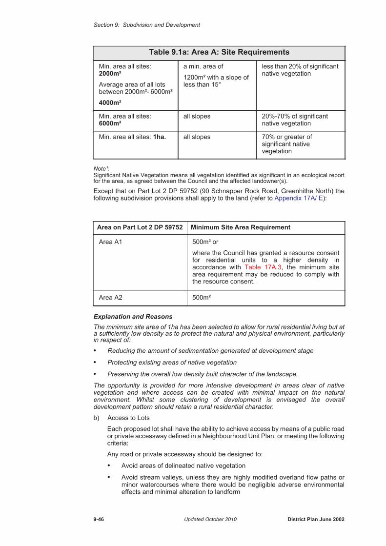
Section 9: Subdivision and Development
Note¹: Significant Native Vegetation means all vegetation identified as significant in an ecological report for the area, as agreed between the Council and the affected landowner(s).
Except that on Part Lot 2 DP 59752 (90 Schnapper Rock Road, Greenhithe North) the following subdivision provisions shall apply to the land (refer to Appendix 17A/ E):
Explanation and ReasonsThe minimum site area of 1ha has been selected to allow for rural residential living but at a sufficiently low density as to protect the natural and physical environment, particularly in respect of:
• Reducing the amount of sedimentation generated at development stage
• Protecting existing areas of native vegetation
• Preserving the overall low density built character of the landscape.
The opportunity is provided for more intensive development in areas clear of native vegetation and where access can be created with minimal impact on the natural environment. Whilst some clustering of development is envisaged the overall development pattern should retain a rural residential character.
b) Access to Lots
Each proposed lot shall have the ability to achieve access by means of a public road or private accessway defined in a Neighbourhood Unit Plan, or meeting the following criteria:
Any road or private accessway should be designed to:
• Avoid areas of delineated native vegetation
• Avoid stream valleys, unless they are highly modified overland flow paths or minor watercourses where there would be negligible adverse environmental effects and minimal alteration to landform
Min. area all sites: 2000m² Average area of all lots between 2000m²- 6000m²
4000m²
a min. area of
1200m² with a slope of less than 15°
less than 20% of significant native vegetation
Min. area all sites: 6000m²
all slopes 20%-70% of significant native vegetation
Min. area all sites: 1ha. all slopes 70% or greater of significant native vegetation
Area on Part Lot 2 DP 59752 Minimum Site Area Requirement
Area A1 500m² or
where the Council has granted a resource consent for residential units to a higher density in accordance with Table 17A.3, the minimum site area requirement may be reduced to comply with the resource consent.
Area A2 500m²
Table 9.1a: Area A: Site Requirements
9-46 Updated October 2010 District Plan June 2002
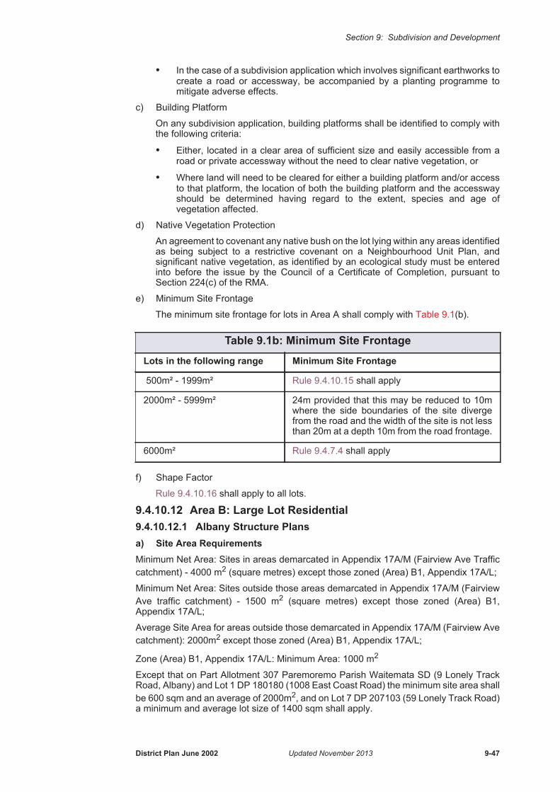
Section 9: Subdivision and Development
• In the case of a subdivision application which involves significant earthworks to create a road or accessway, be accompanied by a planting programme to mitigate adverse effects.
c) Building Platform
On any subdivision application, building platforms shall be identified to comply with the following criteria:
• Either, located in a clear area of sufficient size and easily accessible from a road or private accessway without the need to clear native vegetation, or
• Where land will need to be cleared for either a building platform and/or access to that platform, the location of both the building platform and the accessway should be determined having regard to the extent, species and age of vegetation affected.
d) Native Vegetation Protection
An agreement to covenant any native bush on the lot lying within any areas identified as being subject to a restrictive covenant on a Neighbourhood Unit Plan, and significant native vegetation, as identified by an ecological study must be entered into before the issue by the Council of a Certificate of Completion, pursuant to Section 224(c) of the RMA.
e) Minimum Site Frontage
The minimum site frontage for lots in Area A shall comply with Table 9.1(b).
f) Shape Factor
Rule 9.4.10.16 shall apply to all lots.
9.4.10.12 Area B: Large Lot Residential9.4.10.12.1 Albany Structure Plansa) Site Area RequirementsMinimum Net Area: Sites in areas demarcated in Appendix 17A/M (Fairview Ave Traffic catchment) - 4000 m2 (square metres) except those zoned (Area) B1, Appendix 17A/L;
Minimum Net Area: Sites outside those areas demarcated in Appendix 17A/M (Fairview Ave traffic catchment) - 1500 m2 (square metres) except those zoned (Area) B1, Appendix 17A/L;
Average Site Area for areas outside those demarcated in Appendix 17A/M (Fairview Ave catchment): 2000m2 except those zoned (Area) B1, Appendix 17A/L;
Zone (Area) B1, Appendix 17A/L: Minimum Area: 1000 m2
Except that on Part Allotment 307 Paremoremo Parish Waitemata SD (9 Lonely Track Road, Albany) and Lot 1 DP 180180 (1008 East Coast Road) the minimum site area shall be 600 sqm and an average of 2000m2, and on Lot 7 DP 207103 (59 Lonely Track Road) a minimum and average lot size of 1400 sqm shall apply.
Table 9.1b: Minimum Site Frontage
Lots in the following range Minimum Site Frontage
500m² - 1999m² Rule 9.4.10.15 shall apply
2000m² - 5999m² 24m provided that this may be reduced to 10m where the side boundaries of the site diverge from the road and the width of the site is not less than 20m at a depth 10m from the road frontage.
6000m² Rule 9.4.7.4 shall apply
District Plan June 2002 Updated November 2013 9-47
Section 9: Subdivision and Development
Explanation and ReasonsThe above requirements have been selected to allow for rural-residential development, but at a sufficiently low density as to protect the natural and physical environment, particularly in respect of:
• Reducing the amount of sedimentation generated at development stage
• Reducing the amount of impervious area
• Providing for a site large enough to allow for full on-site stormwater mitigation and for, where relevant, on site wastewater disposal
• Retaining the overall character of the landscape, particularly the low density character of the Lonely Track ridgeline and to the west of the Motorway, the integrity of the Lucas Creek escarpment
• Providing for a transition from urban development to rural development north of the North Shore City boundary.
• Protecting significant and sometimes steep stream corridors, including remnant stream course vegetation and feeder channels.
More conventional residential development has also been provided for at specified locations.
b) Minimum Site Frontage
i) Front Sites:
24m; provided that this may be reduced to 10m where the side boundaries of the site diverge from the road and the width of the site is not less than 20m at a depth of 10m from the road frontage.
ii) Rear Sites:Rule 9.4.10.15 shall apply.
c) Shape Factor
Rule 9.4.10.16 shall apply.
9.4.10.12.2 Greenhithe Structure Plans:a) Site Area Requirements
Except that the average area requirement shall not apply to PT Lot 22 DP 10526; and
Except for land on a lot at 130 Upper Harbour Drive, Greenhithe, legal description Lot 167 DP 34143, where the site area requirements for front lots shall be:
and the site area requirements for rear lots shall be the minimum area and average area requirements applying generally in the zone as set out above.
A range of lot sizes will be required in Area B, with the layout of lots undertaken in a manner which directly related to the environmental constraints of the land and has regard to the need to:
• Minimise the need for earthworks or the removal of trees while ensuring the natural landform and stream pattern are retained and used as the basis for development
Minimum Area: 1500m²
Average Area: 2000m²
Minimum Area: 1000m²
Maximum Number of Front Lots:
4
9-48 Updated November 2013 District Plan June 2002
Section 9: Subdivision and Development
• Protect all significant trees and areas of bush on the land by inclusion in reserves, roads and within large lots with covenants
• Provide larger sites where land has building limitations due to slope, stability or special natural value.
Explanation and ReasonsA minimum site area of 1500m² and an average site area of 2000m² has been selected to allow for rural-residential development, but at a sufficiently low density as to protect the natural and physical environment, particularly in respect of:• Reducing the amount of sedimentation generated at development stage• Retaining the overall low density character of the landscape.b) Minimum Site Frontage
i) Front Sites:24m; provided that this may be reduced to 10m where the side boundaries of the site diverge from the road and the width of the site is not less than 20m at a depth of 10m form the road frontage.
ii) Rear Sites:Rule 9.4.10.15 shall apply.
c) Shape FactorRule 9.4.10.16 shall apply.
9.4.10.13 Area C: Standard Residentiala) Site Area Requirements
Explanation and Reasons
A minimum area of 500m² (700 m2 for parts of 29, 40A and 42 Kewa Road, Appendix 17A/L) has been selected to provide for single detached houses on moderately sized sections, in line with the pattern of development on the North Shore over the last 20 years. The moderately steep slopes and its location away from strategic roads and destinations reduce any potential for higher intensity development.
b) Minimum Site Frontage
Albany Structure Plans:
All Sites - Rule 9.4.10.15 shall apply.
Greenhithe Structure Plans:
All Sites - Rule 9.4.10.15 shall apply.
c) Shape Factor
Albany Structure Plans:
Rule 9.4.10.16 shall apply.
Greenhithe Structure Plans:
Rule 9.4.5.9 shall apply.
Minimum Area: All Sites - 500 m2 (except Area C1, Appendix 17A/L)
Minimum Area: Area C1 - 700 m2
District Plan June 2002 Updated November 2013 9-49
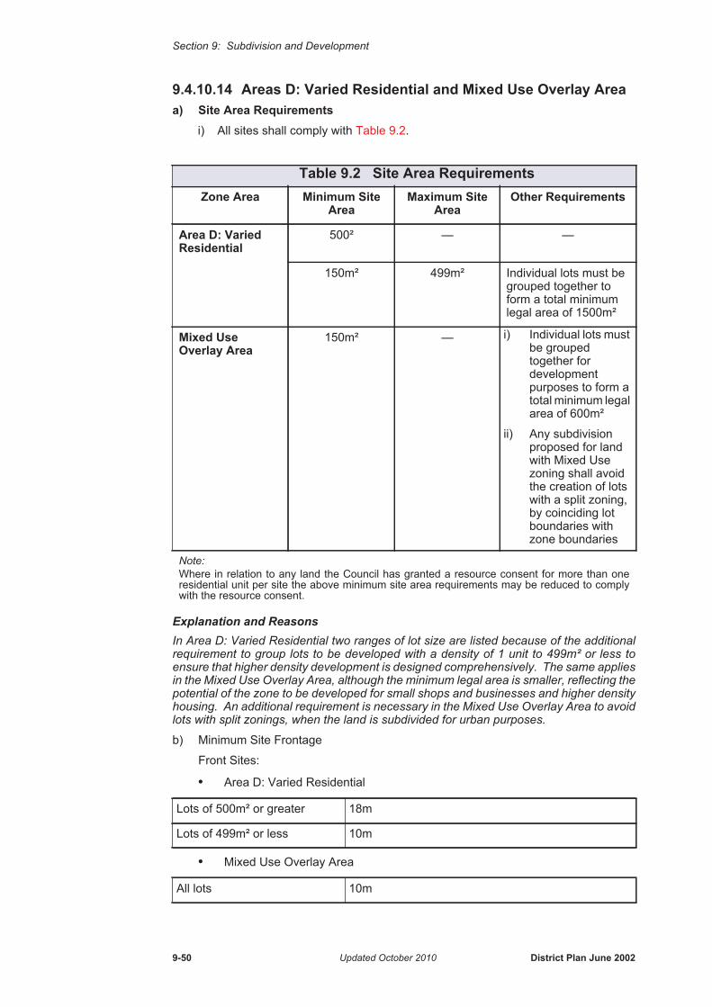
Section 9: Subdivision and Development
9.4.10.14 Areas D: Varied Residential and Mixed Use Overlay Area a) Site Area Requirements
i) All sites shall comply with Table 9.2.
Explanation and ReasonsIn Area D: Varied Residential two ranges of lot size are listed because of the additional requirement to group lots to be developed with a density of 1 unit to 499m² or less to ensure that higher density development is designed comprehensively. The same applies in the Mixed Use Overlay Area, although the minimum legal area is smaller, reflecting the potential of the zone to be developed for small shops and businesses and higher density housing. An additional requirement is necessary in the Mixed Use Overlay Area to avoid lots with split zonings, when the land is subdivided for urban purposes.
b) Minimum Site Frontage
Front Sites:
• Area D: Varied Residential
• Mixed Use Overlay Area
Table 9.2 Site Area Requirements Zone Area Minimum Site
AreaMaximum Site
AreaOther Requirements
Area D: Varied Residential
500² — —
150m² 499m² Individual lots must be grouped together to form a total minimum legal area of 1500m²
Mixed Use Overlay Area
150m² — i) Individual lots must be grouped together for development purposes to form a total minimum legal area of 600m²
ii) Any subdivision proposed for land with Mixed Use zoning shall avoid the creation of lots with a split zoning, by coinciding lot boundaries with zone boundaries
Note: Where in relation to any land the Council has granted a resource consent for more than one residential unit per site the above minimum site area requirements may be reduced to comply with the resource consent.
Lots of 500m² or greater 18m
Lots of 499m² or less 10m
All lots 10m
9-50 Updated October 2010 District Plan June 2002
Section 9: Subdivision and Development
Provided that where a lot is located on a sharp bend and the boundaries of the site diverge from the road the following minimum site frontages shall apply:
i) Lots of 500m² or greater - 10 metres provided that at a point 10metres from the road frontage, the width of the site is not less than 18 metres.
ii) Lots of 499m² or less - 7.5 metres provided that at a point 5 metres from the road frontage, the width of the site is not less than 10 metres.
Rear Sites:
a) Albany Structure Plans:
• Area D and Mixed Use Overlay Area: Rule 9.4.10.15 shall apply.
b) Greenhithe Structure Plans:
• Area D and Mixed Use Overlay Area: Rule 9.4.10.15 shall apply.
c) Shape Factor
i) Albany Structure Plans:
• Area D, lots of 500m² or greater.
Rule 9.4.10.16 shall apply.
ii) Greenhithe Structure Plans:
• Area D, lots of 500m² or greater, except in the case of interim Low Density Development.
• Rule 9.4.5.9 shall apply.
• Mixed Use Overlay Area - in case of Interim Low Density Development: each site shall be able to wholly contain a square 12m by 12m clear of any required building line setback for road widening purposes, foreshore yard, right of way easement, or riparian margin as identified by Rule 8.4.2.
9.4.10.15 Minimum Site Frontage - Area C, Areas D and Mixed Use Overlay Area (Rear Sites)
All sites in Area C: Standard Residential and rear sites in Area D: Varied Residential and Mixed Use Overlay Area shall comply with the following:
a) Each site shall have, or share a frontage or right-of-way to a public road by means of:
• a single entrance strip
• an entrance strip with an easement or easements of right-of-way granted over land adjoining the entrance strip; or
• an amalgamated share of a common access lot; or
• an appurtenant easement or easements of right-of-way over other land
b) Corner sites shall be designed to enable vehicle access to the site to be established which will not significantly detract from traffic safety at the intersection.
c) The minimum total shared frontage and/or entrance strip width shall be determined by reference to Table 9.3.
d) Other Requirements:
• An entrance strip or access lot shall generally not be permitted to serve more than 10 existing or potential residential units, or be greater than 70 metres in length
• An entrance strip shall have a grade no steeper than 20% and all bends shall have an inside turning radius of a minimum of 9 metres
• The carriageway shall be formed, drained and paved to the satisfaction of the Council wherever the entranceway serves, or is intended to serve, more than one lot
District Plan June 2002 Updated June 2012 9-51

Section 9: Subdivision and Development
• Access strips and carriageways shall be designed to optimise traffic safety where they intersect with any public road.
9.4.10.16 Shape FactorEach site shall be able to wholly contain a square of 12m by 12m clear of any required building line setback for road widening purposes, foreshore yard, lakeside yard, right of way easement, the Eadys Bush Protection Line, or riparian margin as identified by Rule 8.4.2, or Significant Landscape Features as identified on the District Plan maps.
9.4.10.17 No Vehicle Access FrontageFor any land identified in Rule 12.4.2.8 Vehicle Crossings, as having a no vehicle access frontage, lots shall be designed with alternative access by means of a private accessway, unless a Limited Discretionary activity application is made in accordance with Rule 12.4.2.8.
9.4.10.18 Mixed Use Overlay Area: Road Reserve Plan1. Mixed Use Overlay Area Bonus Provisions
Additional building height, density and business activity bonuses are available in the Mixed Use Overlay Area in return for a wider road reserve and enhanced street amenity. For the bonus provisions to apply, a road reserve plan must be prepared and approved by the Council.
2. Road Reserve PlanWhere land to be subdivided is identified as a Mixed Use Overlay Area on the relevant Structure Plan Map and in Appendix 17A/ D, and the bonus provisions of the Mixed Use Overlay Area are sought, any application for subdivision of the land shall be accompanied by a Road Reserve Plan. The Plan shall identify the following:
i) Full road width to be vested;
ii) Road surfacing;
iii) Traffic calming;
iv) Onstreet parking;
v) Street tree planting;
vi) Amenity areas of landscaping and design;
vii) Pedestrian areas;
viii) Vehicle crossings.
3. Assessment of the Road Reserve PlanThe Road Reserve Plan shall be assessed against the criteria in Section 9.7.3.10(a) to determine whether the bonus provisions will apply.
Table 9.3 Entrance Strip WidthsNo. of Actual or
Potential Residential Units Served
Minimum Width of Entrance Strip
Minimum Width of Carriageway
up to 2 3.0m 2.5m
3 - 5 3.5m 2.5m
6 or more 6.0m 2.8m plus passing bays
or
4.6m
9-52 Updated November 2013 District Plan June 2002

Section 9: Subdivision and Development
4. Implementation of the Road Reserve PlanIn circumstances where there is an approved road reserve plan and the Mixed Use Overlay Area bonus provisions apply, the following shall apply:
a) the following works shall be carried out as part of the subdivision consent that vests the roads abutting or within the Mixed Use Overlay Area (refer to the relevant Structure Plan Map and Appendix 17A/ D)
• formation of the road carriageway
• street lighting
• special road surfacing for aesthetic or amenity purposes
• construction of footpaths and cycleways
• traffic calming
• formation of onstreet parking spaces to comply with Rule 9.4.10.6
• street tree planting required at the time of subdivision to comply with Rule 9.4.10.7
• formation of vehicle crossings if required.
b)
i) The following works are to be carried out at the land use/development consent stage.
•seating
•pedestrian areas
•landscaping
•street tree planting in addition to that required at the time of subdivision
•formation of additional on-street parking spaces.In the event that development occurs incrementally in the Mixed Use Overlay Area, the cost of implementing these works shall be apportioned on the basis of land area.
ii) On-street parking shall be provided by the developer in accordance with Rule 12.4 and Rule 9.4.10.6.
5. Application of the Mixed Use Overlay Area Bonus Provisionsa) Where the contents of the Road Reserve Plan and the vesting of land for
additional road width is approved by the Council, the Mixed Use Overlay Area bonus provisions shall apply to the land.
b) If the road reserve plan is not approved, then the provisions relating to the Area D: Varied Residential Zone (including the standard roading requirements and usual standards of subdivision) shall apply to the land. Any subdivision or land use consent application will be assessed in accordance with the provisions of the Area D: Varied Residential Zone. The Mixed Use Overlay Area bonus provisions (including Sections 9.4.10.14, 17A.4 and 17A.5 as they relate to the Mixed Use Overlay Area) will not apply to the land.
6. Other MethodsThe Council has limited funds available to further contribute towards the amenity of the public spaces within the Mixed Use Overlay Area.
Prior to the lodgement of any subdivision consent application for land identified as a Mixed Use Overlay Area on the relevant Structure Plan Map and in Appendix 17A/ D, the applicant and the Council shall enter into discussions regarding the Road Reserve Plan, and the sharing of costs for the implementation of road reserve works and the vesting of land for additional road width. Evidence of the consultation and details of any agreed funding/cost sharing arrangement shall be submitted with the
District Plan June 2002 Updated October 2010 9-53

Section 9: Subdivision and Development
application for subdivision consent. The Council shall have regard to the following criteria when considering any funding/cost sharing arangement:-
a) That the Council is satisfied that the subdivision/development and the Road Reserve Plan will enable the intent of the Mixed Use Overlay Area to be met and will facilitate future mixed use development in terms of:
- the road layout
- the location and design of vehicular access; and
- the configuration, orientation and size of proposed lots.
b) That the funding available be applied on a case by case basis to the three mixed-use areas (Albany South, Albany North-East, Greenhithe South).
c) That the developer responsible for implementing the construction of the road reserve has agreed with the Council a satisfactory schedule of works and associated costs for developing the road reserve in conformity with the Council’s general roading standards.
d) That Council funding as approved by the Council be expended, subject to approval from the Environmental Policy and Planning Manager, the Transportation and Traffic Planning Manager and the Parks Manager, on the satisfactory completion of the works identified in 9.4.10.18(4).
Council funding will not be made available towards the cost of road reserve works where the Mixed Use Overlay Area bonus provisions do not apply, and agreement on funding/cost sharing arrangement is not reached and the subdivision proceeds in accordance with the standard provisions of the Area D: Varied Residential Zone.
Where a Road Reserve Plan and funding/cost sharing arrangement is agreed between the Council and the applicant, the details of this shall be confirmed in writing and shall be repeated in an advice note on the subdivision resource consent.
Payment by the Council will be upon satisfactory completion of the agreed works.
Explanation and ReasonsApplications are required to consult with the Council prior to lodging a subdivision consent application, with the view to reaching agreement on a Road Reserve Plan and funding/cost sharing arrangements for road reserve works and the vesting of land for additional road width.
The base costs of implementing the works identified on the road reserve plan are to be met by the subdivider/developer, however Council funding may be made available for works that are over and above the standard of works proposed by the subdivider/developer for the balance of the subdivision/development and/or the minimum District Plan provisions. Council funding is anticipated to be available to contribute towards the cost of special road surfacing, additional traffic calming measures, additional amenity and streetscape works, additional on-street parking spaces, and the value of land vested as road reserve in excess of 20 metres in width. It is probable that the road reserve and carriageways of the affected streets will need to be wider than is usual.
9.4.10.19 Other Relevant Rules - Refer to Section 17A.5 and 17A.6
9.5 Rules: Reservations and Restrictions
9.5.1 Reservations - Matters for ControlCouncil may impose conditions on controlled activities under s108 of the RMA in respect of the following matters over which it has reserved control:
1. Design and implementation of site works (including final ground contours).
2. Layout and design of subdivision.
3. Bulk, height, location, foundations, height of floor levels of any structure on the allotments.
9-54 Updated October 2010 District Plan June 2002
Section 9: Subdivision and Development
4. Location and design of building platforms.
5. Utility services, stormwater, water, waste water, roads (including road access to adjoining land, pedestrian access, service lanes, private roads, vehicle access, parking areas, rights of way, cycle ways and bridle paths).
6. Protection of vegetation and heritage features.
7. The matters provided for in s220(1)(d).
8. Reinstatement and landscaping.
9. Protection of riparian margins.
10. Staging of subdivision.
11. Granting, reserving and extinguishment of easements.
12. Amalgamation of lots, transfers of ownership, ownership for the purpose of providing access in accordance with s220(1)(b), (2) & (3).
13. Vesting of land in the coastal marine area, or bed of a lake or river.
14. Reserves, esplanade reserves, esplanade strips or access strips.
15. Financial contributions.
16. In the Special Purpose: Chelsea Heritage and Conservation Future Use Zone for subdivision for a controlled activity (section 9.4.1.2), in addition to the above matters the provision of 9.4.4 shall apply and matters for control shall also refer to the approved Comprehensive Development Plan.
Explanations and ReasonsThe Council, in the exercise of its discretion may impose conditions with regard to the above matters. For example, the protection of riparian margins may include avoiding the removal of existing riparian vegetation and subsequent enhancement and management of riparian margins (protection and enhancement of vegetation along riparian margins should take into account the principles of protecting the health, resilience, biodiversity and linkages of associated ecosystems).
9.5.2 Restrictions - Limited Discretionary ActivityFor a Limited Discretionary activity, the Council may grant or refuse consent, and (if granted) may impose conditions under Section 108 of the RMA in respect of the following matters over which it has restricted the exercise of its discretion:
1. Design and implementation of site works (including final ground contours).
2. Layout and design of subdivision.
3. Bulk, height, location, foundations, height of floor levels of any structure on the allotments.
4. Location and design of building platforms.
5. Utility services, stormwater, water, waste water, roads (Including road access to adjoining land, pedestrian access, service lanes, private roads, vehicle access, parking areas, rights of way, cycle ways and bridle paths).
6. Protection of vegetation and heritage features.
7. The matters provided for in s220(1)(d).
8. Reinstatement and landscaping.
9. Protection of riparian margins.
10. Staging of subdivision.
11. Granting, reserving and extinguishment of easements.
12. Amalgamation of lots, transfers of ownership, ownership for the purpose of providing access in accordance with s220(1)(b), (2) & (3).
13. Vesting of land in the coastal marine area, or bed of a lake or river.
District Plan June 2002 Updated October 2010 9-55
Section 9: Subdivision and Development
14. Reserves, esplanade reserves, esplanade strips or access strips.
15. Financial contributions.
16. Sites of Geological Significance.
17. Site works within an overland flow path.
18. In accordance with 9.4.1.3 w), where subdivision proposes to create an allotment that lies within 25 metres of a high voltage tranmission line;
a) the extent to which compliance with NZECP 34:2001 will be achieved, and
b) the location and probable future height of any associat ed tree planting, and
c) the extent of proposed earthworks in and around the line and support structures of the high voltage transmission lines
d) retention of emergency and maintenance access
Explanations and ReasonsThe Council in the exercise of its discretion, may impose conditions or refuse to grant consent with regard to the above matters. For example, the location and design of building platforms include consideration of the extent to which any subsequent building or structure is in proximity to a overland flow path, or 1% AEP flood plain and has the potential to result in adverse effects on upstream or downstream properties, Lake Pupuke or the coastal marine area, and the Council retains the discretion to refuse consent.
9.5.3 Restrictions - Limited Discretionary Activity - Rural 4(i) & (ii) Zones
For a Limited Discretionary Activity, the Council may grant or refuse consent, and if granted, may impose conditions under Section 108 of the Act in respect of the following matters over which it has restricted the exercise of its discretion in the respects set out in Rule 9.4.7 and Section 9.7.3:
1. Protection of existing native bush;
2. Protection of riparian margins;
3. Vehicle access;
4. Building platforms;
5. Earthworks;
6. Managing adverse visual effects on rural amenity and the natural character of the coastal environment;
7. Revegetation;
8. Stormwater management;
9. Protection of archaeological sites.
9.6 Rules: Information RequirementsWithout limiting sections 88, or 92 or the Fourth Schedule of the RMA and in addition to any information or plans required under Rule 3.10.7 and Rule 3.10.9 the following information shall be required:
9.6.1 Building PlatformsA suitable building platform shall be identified on every lot on a Plan of Subdivision except lots created for road reserve, reserves, network utility or designation purposes.
9.6.2 Controlled SubdivisionEvery application for a controlled subdivision activity shall be accompanied with sufficient information:
9-56 Updated June 2012 District Plan June 2002

Section 9: Subdivision and Development
a) To demonstrate that all lots to be created by the proposed subdivision comply with Rule 9.4.4 and the relevant standards prescribed by this Plan, in accordance with the zone in which the subject land is located, and
b) To illustrate compliance with Rule 9.4.4.1 and Rule 9.4.4.2, and
c) To complete an assessment of the application in accordance with the applicable Assessment Criteria specified in this Section.
9.6.3 Staging and SubdivisionsWhere a subdivision for other than a cross lease or unit title is likely to be carried out in stages, the developer shall identify this to the Council at the time of application for a subdivision consent and indicate:
a) The estimated time period over which the development is likely to take place.
b) The extent of each stage and the order in which the stages are likely to be subdivided.
9.6.4 Erosion and Sediment Control PlansWithout limiting sections 88(4) or 92 of the RMA and in addition to any information or plans required under Rule 3.10.7 and Rule 3.10.9, any site works over 50m2 shall be accompanied by an ’Erosion and Sediment Control Plan’ which shall:
a) Show the location, area, and depth of all proposed earthworks, cuts or depositions and topsoil or spoil stored on site.
b) Show the contours at 0.5 metre height intervals for existing and finished contours with reference to DOSLI Datum.
c) Show the type and location of the erosion and sediment control measures, such as location of silt fences and other measures.
d) Show the location of any areas of natural hazard on the subject land.e) Show the location of existing trees and include details regarding species, age,
health and general condition.f) Show the location and method/s employed at or before any vehicle exits to avoid
tracking mud and soil onto roads during the period of the site works, including design of a stabilised entranceway.
g) Include a timetable of works including the period of time it is anticipated bare earth will be exposed, the timing and staging of site stabilisation, and the completion of works.
h) Show the location of streams/creeks/ponds on the site and adjoining sites and method/s employed to avoid adverse effects on any adjacent property or waterway, including cumulative and other effects on water quality and aquatic ecosystems arising from site stormwater run-off, such as clean water diversions (e.g. intercept drains/bunds, etc).
i) Show the position of existing and proposed buildings.j) Show the position of overland flow path/s on the site and extending onto adjoining
sites.k) Show existing and proposed stormwater cesspits on the site and on surrounding
sites (including the road reserve).l) State the method of collection and discharge of stormwater from buildings under
construction (e.g. Methods of stormwater discharge from roofs during construction, etc.)
m) Show areas to be rehabilitated and revegetated.n) Provide contact details of site manager responsible for the installation, certification,
and maintenance of erosion and sediment control on site.Provided, that a copy of the ‘Erosion and Sediment Control Plan’, approved by the Auckland Regional Council in the course of granting a resource consent for the same site works shall be deemed to satisfy this requirement.
District Plan June 2002 Updated October 2010 9-57

Section 9: Subdivision and Development
9.6.5 Geotechnical and Hydrological Reports1. Geotechnical Reports
Applications for a resource consent for site works and/or subdivision shall include a ‘Geotechnical Report’ by a Registered Engineer experienced in soil mechanics, (or other suitably qualified and experienced person) where:
a) The affected land is unstable or potentially unstable, subject to erosion, slippage, falling debris or has inadequate foundation soil strengths.
b) Site works are within 5 metres of a cliff face.c) Where any building, or extension to any building, is to be erected within 20m
from the top or the base of any quarry or cliff, or within a horizontal distance from the top, of (1.5) one and a half times the vertical height of the face of any quarry or cliff;
and the required Geotechnical Report shall:
a) Detail the subsoil conditions.b) Set out any limitations on the design or location of buildings, excavations,
drainage or sanitary drainage, appropriate design soil parameters for the safe development of sites without resort to the provisions of Section 36 of the Building Act 1991.
2. Hydrological Reports Applications for a resource consent for site works and/or subdivision where land is subject to flooding hazards shall include a 'Hydrological Report' in accordance with Rule 8.4.9.8.
3. Stormwater Control Reports Applications for resource consent for site works or subdivision in rural, residential, business, structure plan, or urban expansion zones shall include the following information:
a) Location, design, performance and maintenance of the stormwater management features for overland flow paths and stormwater management devices.
b) Capacity of the stormwater system to accommodate stormwater run-off and any means necessary to address potential flooding.
c) Likely contaminants in stormwater run-off and any means to treat or remove them.
Note: Applicants should refer to the adopted NSCC engineering/infrastructure standards as then current and such other Council standards as may be relevant.
9.6.6 Alternative ServicesApplications for a Resource Consent for subdivision on land beyond existing reticulated services shall include evidence to show:a) The services to be provided have been designed for the subject land and that they
have a design life of 50 years.b) That any discharges to land, water or air will have minimal adverse effects on the
natural environment.c) That the proposed water supply shall provide sufficient pressure, capacity and
appropriately located hydrants to afford for the protection of buildings and property from fire.
d) The water quality is appropriate for the purposes for which it is intended, and that any water source impoundment and reticulation is designed and installed in accordance with current legislative and bylaw requirements.
e) Be certified by a suitably experienced Registered Engineer (or other suitably qualified and experienced person).
9-58 Updated June 2012 District Plan June 2002

Section 9: Subdivision and Development
9.6.7 Subdivision of Land Adjacent to a High Noise Route
Applications for any residential subdivision adjacent to a high noise or future high noise route shall be accompanied by an assessment to show:
a) The proximity of the subdivision to any existing or future high noise route.
b) The measures taken in the design and layout of the subdivision to avoid or mitigate the potential effects of unreasonable levels of traffic noise; including but not limited to the incorporation of acoustic fences, earth bunds, parks, reserves and roads in the subdivision design to act as a buffer between the subdivision and the high noise route.
9.6.8 Okura Cultural Heritage SurveyA cultural heritage assessment shall be undertaken prior to subdivision and development of those areas within the Okura catchment, which were not surveyed as part of the Cultural Heritage Assessment undertaken in May 1999. (Refer to Appendix 9B)
9.7 Assessment Criteria
9.7.1 Controlled Activities9.7.1.1 General Assessment CriteriaThe Council shall assess applications for controlled site works and subdivision activities against the following:
1. The Design and Implementation of Site WorksThe extent to which site works, their design, location and execution:
a) Employ adequate and effective techniques or measures to capture and retain any sediment generated through site works and/or associated earthworks and prevent the passage of sediment over land, and/or entry of sediment into water systems, whether naturally occurring or otherwise.
b) Appropriately minimise site disturbance and vegetation clearance.
c) Utilise recognised methods and techniques for managing effects on long term water quality and aquatic ecosystems.
d) Are proximate to and provide for the maintenance and protection of:
i) Protected trees.
ii) Cliff faces/cliff tops.
iii) Sites of geological significance.
iv) Significant landscape features.
v) Steeply contoured land.
vi) Reserves.
vii) Areas of unstable land or other known natural hazard.
viii) Streams, stormwater drains, lakeside or foreshore yards.
ix) Overland flow paths
x) 1% AEP flood plains.
e) Avoids the elevation of activities on raised ground levels, obscuring views from, visually dominating or overshadowing adjacent sites and neighbouring sites.
f) Are required by the need to provide safe and stable building platforms and access and by the need to provide utility services, (particularly undergrounded).
District Plan June 2002 Updated June 2012 9-59

Section 9: Subdivision and Development
g) Adequately provides for reinstatement, revegetation and landscaping.
h) May adversely affect land stability.
i) May adversely affect drainage.
j) May modify landforms within the foreshore yard.
k) Avoids the creation of any impediment to flood water flow within the 1% AEP flood plain or overland flow paths.
l) The extent to which site works within an overland flow path or the 1% AEP flood plain materially changes the location, scale, intensity, and/or direction of water flow and/or flood waters.
m) The extent to which site works within the 1% AEP flood plain remove vegetation or limit the ability of the flood plain to function naturally.
2. Layout and Design of SubdivisionThe extent to which the design and layout of the subdivision:
a) Maintains or enhances amenity values.
b) Is sympathetic with, responds to and reflects the environmental characteristics of the land and its surrounds.
c) Establishes or contributes to the identity of the local area.
d) Works with, protects, and where appropriate, enhances, natural waterways and overland flow systems.
e) Ensures lot boundaries are compatible with topographical features.
f) Avoids the clearance of native trees and bush.
g) Results in the sitting of individual lots to avoid natural hazards such as flooding in accordance with Rule 8.4.9.
h) Takes best advantage of views.
i) Ensures that lots are large enough to ensure that future buildings can meet the relevant standards and development controls of the zone.
j) Ensures lots are of a useable shape.
k) Provides for the ease and safety of access and egress to and from lots.
l) Makes provision for and retains existing horse trails (after consultation with the parks department).
m) Provides for the provision and maintenance of utility services.
n) Provides or enhances existing open space.
o) Enables stormwater management to appropriately utilise, protect and where appropriate, enhance existing natural features, including native vegetation and waterways to avoid adverse effects arising from stormwater run-off.
p) Minimises the extent of impervious surfaces to reduce stormwater run-off.
q) Avoids the creation of constraints that will limit or reduce the ability of a site to comply with on-site stormwater management requirements in Rule 8.4.7.
r) May protect an overland flow path on any site containing an overland flow path with a catchment area greater than 4,000m² or 1% AEP flow greater than 100 litres per second, by requiring an easement.
Note: The North Shore City Council maintains engineering/infrastructure policies and standards which should be referred to when considering the requirements of this assessment criterion.
9-60 Updated June 2011 District Plan June 2002

Section 9: Subdivision and Development
3. Bulk, Height, Location, Foundations, Height of Floor LevelsThe extent to which:
a) The bulk, height or location of structures may not be able to comply with Rules applicable to subsequent development, prescribed in accordance with the District Plan.
b) Any proposed separation distances between building platforms, areas of natural hazard, heritage features, archaeological sites and electricity supply lines are appropriate and/or adequate.
c) The adverse effects of stormwater inundation or other natural hazard are avoided including:
i) By ensuring that the floor level of any proposed habitable residential building in the coastal inundation area or flood sensitive area is in accordance with Rule 9.4.3.3(a)(ii).
ii) By ensuring that the floor level of any proposed building, other than habitable residential buildings, in the coastal inundation area or flood sensitive area is above the 1% AEP flood level.
d) Any proposed building or structure to be located within an overland flow path is designed to prevent any impediment to the passage of flood waters, or creates any potential adverse effects on upstream or downstream properties.
4. Location and Design of Building PlatformsThe extent to which the location and design of building platforms:
a) Avoid land subject to natural hazards.b) Avoid creating or exacerbating natural hazards.c) Mitigate adverse affects on visual amenity.
5. Utility Services, Drainage, Water, Wastewater, Electricity, Roads a) The extent to which the location design and construction of network utilities
results in structures whose bulk, height and ground coverage avoid, remedy or mitigate:
i) The physical domination of adjoining sites.
ii) Obstructing views from adjacent sites.
iii) Detracting from the character of the neighbourhood.
b) The extent to which the design of stormwater systems and sanitary drainage systems:
i) Are accessible for maintenance.
ii) Can withstand load due to settlement.
iii) Ensures water-tightness.
iv) Is provided for in the proposed staging of works.
v) Maintains the integrity of the system with reference to connections, componentry, compatibility and maintenance.
vi) Is adequate and appropriate with reference to any statutory requirements and the potential future uses of the land which they serve, including upstream catchments.
vii) Protect against the possibility of being built over.
viii) Is protected from ground water and/or stormwater infiltration.
c) The extent to which the design of stormwater systems is in accordance with Rule 8.4.8 for on-site stormwater management and:
i) Avoids water pooling around building foundations, flood damage, and the inundation of buildings.
District Plan June 2002 Updated June 2011 9-61

Section 9: Subdivision and Development
ii) Provides for overland flow paths.
iii) Is in accord with the provisions of a Stormwater Catchment Management Plan that has been prepared for the area.
iv) Avoids the likelihood of leakage, root penetration and infiltration of groundwater.
v) Incorporates features to provide stormwater attenuation, remove contaminants from stormwater runoff and avoid damage to natural waterways and reduce erosion.
vi) For sites which are unserviced, ensures that there is no increase in stormwater run-off (for example through the use of storage tanks to enable rainwater re-use on-site).
vii) Incorporates the use of natural areas and vegetation in stormwater detention, (including enhancing existing vegetation to improve stormwater quality and to protect or enhance affected aquatic ecosystems. This may also include, where appropriate, redirection of stormwater to natural areas).
viii) Are designed in such a way as to minimise the amount of impervious surfaces.
d) The extent to which the location, design and construction of public water supply mains:
i) Provides adequate fire fighting capacity (including the provision of fire hydrants).
ii) Provides for water metering.
e) The extent to which the location, design and construction of sanitary drainage:
i) Protect against the possibility of being built over.
ii) Is protected from ground water and/or stormwater infiltration.
f) The extent to which the reticulated supply of electricity:
i) Is undergrounded in the residential and business zones.
ii) Is provided for in an efficient manner.
iii) Maintains the integrity of the reticulated system with reference to connections, componentry, compatibility and maintenance.
iv) Provides for access for maintenance.
g) The extent to which the location, design and construction of proposed roads:
i) Results in road reserve widths sufficient to cater for the functions the road is expected to fulfil in the roading hierarchy.
ii) Results in roads and privateways made of material which provide adequate strength, durability and acceptable maintenance costs.
iii) Maintains the integrity of the system with reference to intersections, materials, surfaces, drainage, alignment and maintenance.
iv) Ensures safe and efficient pedestrian, cyclist and vehicle movements (including emergency vehicle movements), with reference to the location and control of intersections, the use of a mix of gradients, widths, alignments, paving materials and lighting.
v) Provides linkages to other (existing and proposed) roads, open space and community facilities.
vi) Incorporates drainage systems which are adequate and appropriate with reference to their potential future use.
vii) Provides footpaths with a sufficiency of kerb cuts, which aid pedestrian mobility (including young, elderly and lesser-abled persons), mail deliveries and will likely meet future use patterns.
9-62 Updated October 2010 District Plan June 2002

Section 9: Subdivision and Development
viii) Ensures the appropriate locations of adequate parking, passing bays and space for vehicle manoeuvring.
ix) Enables the efficient provision of utility services.
x) Contributes to the visual amenity of the streetscape.
xi) Takes advantage of any potential for providing views, particularly to significant landscape features, across the city, and the Hauraki Gulf.
xii) Make provision for street lighting and illumination to provide for traffic and personal safety.
xiii) Provides for appropriate stormwater management to reduce the volume of stormwater runoff discharging into the network.
h) The extent to which privateways:
i) Provide safe and convenient access in all weathers.
ii) Are appropriate with reference to the potential use of the land they serve.
iii) Are designed to carry wheel loads of all potential moving or parked vehicles using it (including fire engines where hydrants are to be installed with the private way) without edge fretting.
iv) Provide for access to network services for maintenance purposes.
v) Incorporates drainage systems which are adequate and appropriate with reference to the Council’s engineering standards and the potential future uses of the land which they serve.
Note: refer also to rule 12.4.3.3 Minimum Road and Service Lane Widths.
6. Protection of Vegetation and Heritage FeaturesThe extent to which site works and/or subdivision reduce the features’ visibility, presence or integrity by establishing, undermining, covering, masking or obscuring, demolishing or removing parts, elements or components of the feature.
7. Reinstatement and Landscaping
The extent to which:
a) Provision is made for landscaping in the road berms and on the lots created.b) Such landscaping contributes to the amenity values of the street scene and the
local area.c) Vegetation removed in the course of development is reinstated in accordance
with the objectives and policies of the zone in which the development is located.
d) Earthworks incorporate the reconditioning of surface soils in areas to be set aside as parks and reserves.
8. Staging of SubdivisionThe extent to which:
a) The proposed subdivision mitigates the effects of site works and construction through the staging of the works and development.
b) The extent to which the staging avoids extended time frames for site works.
9. The Matters Provided for in s220(1)(d)10. Granting, Reserving and Extinguishment of Easements11. Amalgamation of Lots, Transfers of Ownership, Ownership for the Purpose of
Providing Access in Accordance with s220(1)(b), (2) and (3)12. Vesting of Land in the Coastal Marine Area, or of Bed of a Lake or River
District Plan June 2002 Updated June 2011 9-63

Section 9: Subdivision and Development
13. Esplanade Reserves, Esplanade Strips of Access stripsThe above items (9-13) shall be assessed in accordance with the provisions of the RMA, relevant legislation and regulation, the provisions of this Plan and the need to ensure the certainty of supply, provision or maintenance of utilities and access and/or responsibilities attributable to ownership or occupation.
9.7.1.2 Albany and Greenhithe Structure Plans Zone Assessment Criteria
In addition to the General Assessment Criteria for Controlled Activities listed in Rule 9.7.1.1, the Council will assess applications for subdivision listed as a Controlled Activity in the Albany and Greenhithe Structure Plans zone as provided for in Section 17A against the following criteria. The following criteria will also be used when assessing applications for subdivision listed as a Limited Discretionary activity in the Albany and Greenhithe Structure Plans zone as provided for in Section 17A under Rule 9.4.1.3. To the extent to which any of the following criteria deal with matters which are identified on a Neighbourhood Unit Plan, Compliance with that Neighbourhood Unit Plan will be deemed to satisfy that criterion in full or in part:
9.7.1.2.1 IdentityThe extent to which:
a) The subdivision contributes to the creation of a residential area with a strong identity by responding to the land's natural characteristics, setting, landmarks and views,
Explanation and ReasonsSubdivision design is subject to a range of standards including servicing, road design, and reserve requirements. These general standards need to be balanced by an analysis of the specific characteristics of the land which should also help to determine how a subdivision is designed. The analysis should assist the process not merely as a constraint, but also in a positive way by identifying the potential for reinforcing a sense of local identity.
9.7.1.2.2 EarthworksThe extent to which earthworks proposed for initial earth-working of the land for subdivision purposes within the Coastal Conservation Area in the Greenhithe Structure Plans zone, meet the following criteria:
a) Retains surface vegetation along riparian margins to act as a riparian buffer to the transport of sediment is not significantly reduced,
b) Avoids the installation of services within riparian margins unless there are compelling reasons for locating them within this area.
Explanation and ReasonsThe Greenhithe South Structure Plan area is bounded to the north by a considerable frontage to the Te Wharau Creek. Because of considerable sedimentation of that creek in recent years, it is important that earthworking and land disturbance is kept back from the margins to allow for a riparian buffer strip.
9.7.1.2.3 Street LinkagesThe extent to which:
a) Proposed streets link with any key route identified on any relevant Structure Plan or Neighbourhood Unit Plan.
b) Proposed streets have the potential to link with future streets on adjacent land.
c) The street network may be easily comprehended.
d) The subdivision assists direct connections by motor vehicles. In cases where the topography or physical characteristics of the land pose difficulties, a proposed street, which does not have interconnection, may be acceptable if it is short in length and runs directly off an interconnected street.
e) The street network allows a choice of routes so that the most direct route may be
9-64 Updated October 2011 District Plan June 2002
Section 9: Subdivision and Development
chosen to any destination.
f) Streets that do not provide direct interconnections connect directly to a through road or are required in response to topographical or physical constraints.
Explanation and ReasonsThese criteria are aimed to ensure a high level of interconnection in the local street network to reduce the number and length of local vehicle trips and spread traffic volumes, which has air and noise pollution benefits. A well connected street system also assists in making suburban areas more legible.
9.7.1.2.4 Street DesignThe extent to which:
a) Proposed roading provides safe and convenient access throughout the residential area and into adjacent areas.
b) Where key routes cross the reserve/open space linkages identified on any Structure Plan or Neighbourhood Unit Plan, regard is had to an appropriate balance between costs and environmental considerations in assessing the type of bridging or piping structure.
c) The design of any proposed streets is in accordance with Appendix 12I: Roading Design: Technical Supplement in terms of:
i) controlling traffic speed,
ii) controlling traffic volumes,
iii) providing appropriate parking bays for on-street parking,
iv) ensuring that service roads are safely integrated with the adjacent road network.
d) On-street communal parking is provided in indented bays. Indented bays may incorporate driveways but should be designed to ensure appropriate clearances.
e) Roads bordering part of a reserve only are designed to achieve maximum frontage to the road and to provide a useable shape.
Explanation and ReasonsThe requirement for the bridging of Key Routes across reserve/open space linkages is based on the need to avoid adverse environmental effects caused by the filling of stream valleys.
Within the Structure Plan areas the road system is required to be designed to distinguish between traffic routes with higher volumes, whose major function is through traffic, and residential streets with low volumes, whose main function is local access for vehicular and non-vehicular modes. Appendix 12I: Roading Design: Technical Supplement provides road design criteria to control traffic speed and volumes. The effect of implementing these criteria should be to allow the shared use of residential streets by pedestrians and cyclists in a safe environment.
All on-street parking should be designed in parking bays. Bays may incorporate driveway accesses to adjacent properties, but sufficient clearance should be allowed for safe manoeuvring. Bays may provide for the parking of a number of vehicles, as long as there are sufficient bay projections to effectively narrow the carriageway to minimum through traffic width.
9.7.1.2.5 Incorporation of Natural FeaturesThe extent to which the visual amenity of the street system is enhanced, by integrating streets or parts of streets with existing significant natural features.
Explanation and ReasonsAll opportunities should be taken to enhance the amenity of localities by incorporating within a road reserve, small areas of native vegetation or other local features.
District Plan June 2002 Updated October 2010 9-65

Section 9: Subdivision and Development
9.7.1.2.6 Pedestrian and Cycle LinkagesThe extent to which pedestrian and cycle movements are facilitated to provide access to key external destinations, major shopping centres and local focal points, major public transport routes, Key Routes identified on the Structure Plans, as well as to provide recreational opportunities within the reserves / open space linkages.
(Note also Rule 9.4.10.4: Pedestrian and Cycle Only Linkages and Appendix 4 to the Planning Maps: Proposed Cycle Facility Plan).
Explanation and ReasonsThe design of residential subdivisions should ensure that residents are encouraged to walk or cycle to local destinations. For roads where traffic volumes will be relatively high, that may mean separate cycleways or a widened traffic lane. Local residential streets should be designed to limit traffic volumes and speed so that cyclists feel safe to share them with vehicles. In addition, cycle and pedestrian routes should be provided through reserve linkages for recreational purposes.
9.7.1.2.7 Reserves/Open Space LinkagesThe extent to which public reserves are located in accordance with reserve/open space linkages indicated on any relevant Structure Plan or Neighbourhood Unit Plan. In determining the location and extent of land to be vested as public reserve, the Council shall be guided by the following criteria:
a) Provision of reserves in the neighbourhood
Whether the vesting of such land as a recreation reserve would achieve the optimum pattern of reserves in the neighbourhood, having regard to:
• the relevant provisions of the Council's Open Space Strategy and of the Structure Plan
• the statutory ability to obtain the land as reserve contribution on subdivision or development, or (where additional land is required) to negotiate its purchase from the reserves contribution account
• Whether the acquisition of the land can be justified having regard to other needs for recreation reserves in the locality.
b) Protection of land adjacent to watercourses
Within the framework set out in (a) above, priority should be given to vesting such land in the Council as a recreation reserve or placing private covenants on land, where it is important:
• as a landscape feature which provides a natural focus for views and contributes to the identity and amenity of the residential area, including the protection of significant vegetation and regenerating bush, and the ability to enhance these visual qualities through additional plantings;
• as an ecological resource, because of the nature of the vegetative cover, habitat values, the effects on habitat values downstream and the ability to function as an ecological corridor;
• to provide pedestrian and cycle linkages to destinations such as the Mixed Use Overlay Areas, located and designed to afford maximum visibility for safety and security reasons;
• to provide opportunities for local play areas and recreational linkages for walking, jogging and cycling, located and designed to afford maximum visibility for safety and security reasons.
c) Width of land needed for protection
The amount of such land protected on either side of the water course should be sufficient to provide for:
• the considerations set out in (a) above
9-66 Updated October 2010 District Plan June 2002

Section 9: Subdivision and Development
• the landscape, ecological, linkage and recreation purpose for which it is required, as set out in (b) above
• a vegetated buffer sufficient to ensure a shaded and cool aquatic environment.Private covenants should be placed on land where it is required solely for the protection of environmental resources, including minor watercourses and vegetation and where the land is located in lower density residential areas;
Land is more likely to be vested as a recreation reserve in a moderate to higher density residential area due to the greater demand for public use, than in a low density residential area;
Where land is required for a detention pond as part of the comprehensive management of the catchments’ stormwater, it is part of the infrastructure for the subdivision and should not attract a reserve contribution credit.
Explanation and ReasonsThe question of whether reserve/open space linkages identified on the Structure Plans should be protected by vesting as public reserve, or by placing a private covenant on the land, and the width of the land to be protected, needs to be made on an area specific basis. The above criteria are sufficiently detailed to guide that process.
9.7.1.2.8 Stormwater Detention PondsIn the Greenhithe Structure Plans, the extent to which detention ponds for stormwater control purposes are provided, as specified in the appropriate Catchment Management Plan. Where required (for example, where land upstream of identified ponding areas is subdivided and/or developed prior to the installation of ponds further downstream), the means by which the requirements of Rule 8.4.8 for on-site stormwater management are also met.
Explanation and ReasonsRelevant catchment management plans identify the location of future detention ponds for stormwater control and quality purposes. Subdivision plans need to reflect those requirements. It should also be noted that on-site stormwater management is also required to be considered.
9.7.1.2.9 Passenger TransportThe extent to which:
a) The design of the subdivision supports public transport accessibility and efficiency.
b) All Key Routes identified on a Structure Plan or Neighbourhood Unit Plan are designed to act as passenger transport routes.
Explanation and ReasonsIf the Structure Plan areas are to be adequately served by public transport in the future, it is important the roading network is designed in a manner that will facilitate future public transport.
9.7.1.2.10 Northern Motorway Buffer AreaThe extent to which a motorway buffer area of a minimum width of 50 metres is indicated on the Albany Structure Plans. Buffer Area land should be used for visual and acoustic protection measures and will need to be incorporated into the motorway's road reserve.
9.7.1.2.11 Services and InfrastructureThe extent to which:
i) Where services are planned to be provided to serve an individual subdivision, account should be taken of the needs of the whole Neighbourhood Unit or Structure Plan area in determining the appropriate capacity and location of services.
ii) Any services proposed along reserve and stream corridors are located in a manner that avoids adverse efffects on the watercourse and significant vegetation.
District Plan June 2002 Updated June 2011 9-67
Section 9: Subdivision and Development
Explanation and ReasonsThe intention of the above criteria is to ensure that the planning for servicing of new areas is undertaken in a comprehensive way and that adverse effects on streams and native vegetation are as far as possible avoided.
9.7.1.2.12 Street Planting & LandscapingThe extent to which:
i) Landscaped public amenity areas are provided as part of the development of road reserves within the Mixed Use Overlay Areas.
ii) Tree planting, including the planting of specimen trees, is provided within road reserves, along key routes, at intervals, which will ensure a consistent visual succession.
iii) Local reserves are landscaped and planted in accordance with a landscape plan, which defines the space in a relatively formal manner and provides a visual focus to the locality.
iv) Landscaping is appropriate to the locality.
9.7.2 Limited Discretionary ActivitiesThe Council shall assess applications for limited discretionary site works and subdivision activities against the following:
9.7.2.1 General Assessment CriteriaThe General Assessment Criteria for Controlled activities listed in Rule 9.7.1.1.
9.7.2.2 Site Works on Sites of Geological SignificanceThe extent to which:
a) The nature, form and extent of site works modify the site and reduce its significance.b) The site works are necessary.c) Alternative methods or location are available to the applicant for carrying out the
work or activity.d) There exists an opportunity for an expert to record the details of the site.e) The site works accord with any relevant management plan.
9.7.2.3 Subdivision in Residential 1 ZoneIn addition to the general assessment criteria above, the Council will also assess applications in the Residential 1 zone in accordance with the following criteria:
a) The extent to which the proposed subdivision contributes to the identity of the local area by:
i) The location and orientation of street and open space networks.ii) The use of landscaping and, in particular, the planting of forest scale trees
along major traffic routes, and nodes such as local shops and reserves, so that they become attractive, visible public areas.
iii) Creating or adding to existing reserves, which form a network of reserves incorporating important natural features and include well distributed neighbourhood reserves.
b) The extent to which the proposed subdivision provides internal and external access for vehicles, pedestrians and cyclists, (especially to the main destinations identified in the Assessment of Effects) by:
i) The influence of the subdivision’s layout on local vehicle travel distances.ii) Maximising public transport effectiveness.iii) Facilitating walking and cycling to daily activities.
c) The extent to which the proposed subdivision protects natural environmental values by protecting all significant trees, areas of bush, streams and wetlands on the land by their inclusion in reserves, roads and within large lots with covenants (where appropriate).
9-68 Updated October 2010 District Plan June 2002
Section 9: Subdivision and Development
9.7.2.4 Subdivision in Residential 2A, 2A1, 2B and 2C ZonesIn addition to the general assessment criteria above, the Council will also assess applications in the Residential 2A, 2A1, 2B and 2C zones in accordance with the following criteria. The extent to which the proposed subdivision:
a) Ensures that the landscape and habitat values which characterise the subject land, such as sizable blocks or continuous corridors of native bush and natural watercourses, are retained.
b) Demonstrates (in Residential 2C zone only) that it will be possible to establish a dwelling and associated access in accordance with the requirements of Rule 16.6.1.14 Eadys Bush Protection Line.
9.7.2.5 Subdivision in Residential 3 ZoneThe extent to which proposed subdivision in the Residential 3 zone maintains the existing built heritage streetscape and building character by:
a) Retaining existing houses constructed prior to 1930 that may be on the subject land.
b) Ensuring that the area and shape of the lots relate to existing neighbouring buildings, the spaciousness of their settings, and any existing vegetation, streams or wetlands on the parent site.
9.7.2.6 Subdivision in Residential 5 ZoneThe extent to which any proposed subdivision in the Residential 5 zone provides for a range of lot sizes and a lot layout which directly relates to the environmental characteristics of the land, as identified in the Assessment of Effects on the environment required for this zone.
9.7.2.7 Subdivision in Residential Zones Involving Control Flexibility
The extent to which the proposal:
a) Is in accordance with the purpose of providing for control flexibility.
b) Exacerbates any adverse effects arising from the proposal.
c) Gives rise to new adverse effects.
9.7.2.8 Subdivision Creating Rear Sites in Business 7, 9, 10 and 11 Zones
Applications to create rear sites in the Business 9, 10 [and 11] zones shall consider the extent to which:
a) Direct road access would be preferable.
b) The creation of a rear site will not obstruct or delay the provision of such a road in the future.
c) Will promote the better use of the land having regard to the following criteria:
• The existing subdivision pattern
• The existing or proposed roading layout
• The nature of the intended activity
• The physical characteristics of the site
• The configuration of any site boundary
• The existing development pattern of the locality.
District Plan June 2002 Updated October 2010 9-69

Section 9: Subdivision and Development
9.7.2.9 Subdivision in the Business Zones Involving Control Flexibility (Landscaping)
Assessment of an application for a reduction in the landscape area requirements when considering a subdivision application, in accordance with the Control Flexibility under Rule 15.6.2.8, shall consider the extent to which the proposed landscaping:
a) Will achieve high amenity through a comprehensive approach to landscaping for the development.
b) Will achieve a coherent appearance over the wider street scene.
c) Meets the requirements of Rule relating to landscape amenity yards and the planting of specimen trees.
d) Satisfies the assessment criteria contained in Rule 15.7.4.
9.7.2.10 Subdivision in the Albany and Greenhithe Structure Plans Zone
In addition to the General Assessment Criteria of Rule 9.7.1, the Council shall assess applications for subdivision listed as a Limited Discretionary activity in the Albany and Greenhithe Structure Plans zone against the following:
a) The assessment criteria of Rule 9.7.1.2: Albany and Greenhithe Structure Plans zone Assessment Criteria.
9.7.2.11 Subdivision in the Albany and Greenhithe Structure Plans Zone involving Control Flexibility
a) In the case of a subdivision not complying with Rule 9.4.10.2.1 Intersections, the extent to which:
i) A proposed intersection would not impede traffic flows or compromise traffic safety.
b) In the case of a subdivision not complying with Rule 9.4.10.3 Pedestrian and Cycle Facilities, the extent to which pedestrian and cycle facilities are provided on all roads, except for roads which are not through routes and which serve a small number of dwellings.
c) In the case of a subdivision not complying with Rule 9.4.10.4 Pedestrian/Cycle Only Linkages, the extent to which a proposed link would:
• Be of relatively short length
• Allow visibility along it from adjacent streets, or good surveillance opportunities exist and escape points from the link are available
• Be lit at each end
• Not compromise the safety and security of pedestrians or dwellings and private outdoor spaces.
d) In the case of a subdivision not complying with Rule 9.4.10.6 On-Street Parking, the extent to which a satisfactory level of on-street parking is provided, taking account of the provision of on-street or public parking in the vicinity and the amount of parking intended to be provided on-site.
e) In the case of a subdivision not complying with Rule 9.4.10.7 Street Planting & Landscaping, the extent to which planting proposed would:
i) Be appropriate in the locality, and
ii) Be sufficient to ensure a consistent visual succession of greenery.
f) In the case of a subdivision not complying with Rule 9.4.10.8, Neighbourhood Reserves and Roads, the extent to which:
i) Substantial cut and fill is required to form a road bordering a reserve would adversely affect ecological or landscape values, thereby making a road in that location inappropriate.
9-70 Updated October 2011 District Plan June 2002
Section 9: Subdivision and Development
ii) It is important to have roads bordering a neighbourhood reserve, because of the significance of the neighbourhood reserve and the need for it to have good visibility and public access.
iii) Where road(s) are proposed to border part of a neighbourhood reserve only, the extent to which the reserve is designed to achieve maximum frontage to the road(s) and to provide a useable shape.
iv) Good visibility from adjacent dwellings, streets and other public spaces is provided.
g) In the case of a subdivision not complying with Rule 9.4.10.9 Neighbourhood Reserves, the extent to which:
i) A proposed reserve is undersized, but is of a sufficient size for existing and future local recreational purposes, given the provision of other reserve space in the locality that meets a Neighbourhood reserve purpose.
ii) A proposed reserve does not satisfy the locational requirements of the rule, but there are other over-riding positive benefits from the location.
iii) A proposed reserve is on land of more than 5° slope, but it satisfies locational requirements and is suitable for its identified reserve classification purpose, or there is no other suitable flatter land.
iv) Where road(s) are proposed to border part of a reserve only, the extent to which the reserve is designed to achieve maximum frontage to the road(s) and to provide a useable shape.
v) Good visibility and access from streets and other public spaces is provided.
h) In the case of a subdivision in the Greenhithe South Structure Plan Area not complying with Rule 9.4.10.10: Greenhithe South Structure Plans Zone: Relationship between Lots for Higher Density Housing and Open Space, the extent to which:
i) All lots intended for housing units at a density of 1 unit per 499m2 or less are located to enable easy pedestrian access to an area of public reserve or private open space.
ii) Areas of public reserve or private communal open space intended to satisfy the requirement of standard 9.4.10.10(b) are sufficiently large to provide a locally significant, visual contrast to the built environment, and sufficiently level to allow informal recreational use.
9.7.2.12 Compliance with the Albany Centre Structure PlanLimited discretionary applications for control flexibility in relation to compliance with the Albany Centre Structure Plan shall be assesed against the criteria listed in Section 15.7.4.17.
9.7.2.13 Subdivision in the vicinity of High Voltage Transmission Lines
In addition to the general assessment criteria in Rule 9.7.1.1, the Council shall assess any proposal to create an allotment that lies within 25 metres of high voltage transmission lines against the following;
i) The extent of compliance with NZECP 34:2001 and the potential effects on users or occupiers of land
ii) Location of building platforms and whether there are alternative building platforms available
iii) The nature and location of any proposed earthworks and/or vegetation to be planted in the vicinity of transmission lines.
iv) The ability of the line owner to retain access to the high voltage transmission line for inspections and maintenance and emergency purposes
District Plan June 2002 Updated October 2010 9-71
Section 9: Subdivision and Development
9.7.3 Discretionary ActivitiesWithout restricting the exercise of Council’s discretion, the Council’s assessment of applications for discretionary site works and subdivision activities may include the following as applicable:
9.7.3.1 General Assessment CriteriaThe General Assessment Criteria for Controlled activities listed Rule 9.7.1.1
9.7.3.2 Site Works and Subdivision on Land Subject to Natural Hazards, Significant Landscape Features and Sites of Special Wildlife Interest
a) The extent to which the proposed site works and/or subdivision:
i) Is consistent with the Objectives and Policies of the Plan.
ii) May create soil instability or lead to adverse ecological effects on habitats, watercourses, wetlands, estuaries or coastal waters.
iii) Is required to establish a stable building platform, access or the provision of utility services as permitted by the zone rules.
iv) Is required to avoid, remedy or mitigate natural hazards or to conserve the resources of the area.
v) Is preferable to any alternative methods or options that may be available to the applicant, including relaxation of controls which might avoid the need for the proposed work to modify the natural landform.
b) The extent to which the Geotechnical Report and Hydrological Report required under Rule 9.6.5 satisfies potential issues raised by the natural hazard.
c) The extent to which site works and/or earthworks affecting land subject to natural hazards comply with the contents of any relevant Catchment Management Plan prepared by the Council and requirements elsewhere in the District Plan.
d) The adequacy and appropriateness of proposed methods for the reinstatement and stabilisation of areas of cut and fill by way of revegetation, landscaping, drainage, or other stabilising methods.
e) The adequacy and appropriateness of proposed means of avoiding or controlling soil erosion and siltation during site works and/or earthworks and the construction phase, including minimising areas of earthworks.
f) When considering any application for site works and/or earthworks within the foreshore or lakeside yard, riparian margin, affecting land that has a gradient of 1:4 or greater, a significant landscape feature or other sensitive environment the Council shall have particular regard to the extent to which:
i) Any recontouring, filling or excavation works adversely affect the visual quality of the landscape.
ii) The works create any damage, danger or nuisance to adjacent or adjoining lots.
iii) Desirable existing vegetation of high quality is retained or improved.iv) The viability of habitats is diminished.v) The works lead to adverse ecological effects to natural habitat, watercourses,
wetlands estuaries or coastal waters.vi) The works adversely affect the natural landform of any ridges, escarpments or
other significant features, including riparian margins.vii) The works would alter or affect the natural ground level of a cliff top, add to the
overburden or otherwise having an adverse effect on stability or visual amenity.viii) The works are adequately stabilised during construction to avoid erosion.ix) Appropriate measures are implemented to ensure stormwater runoff is
minimised over the area of sitework.x) The works are minimised to reduce the potential scale of sediment generation.
9-72 Updated June 2012 District Plan June 2002

Section 9: Subdivision and Development
g) The extent to which the site works or subdivision make special provision for the retention and protection of the significant landscape feature.
h) The extent to which the design and layout of the subdivision avoids adverse effects on the significant landscape feature by appropriate location of building platforms, structures, lot boundaries, roads and vehicle access.
i) The extent to which flocculation within erosion and sediment control ponds is undertaken in order to achieve efficiencies in retaining fine-grained sediment.
j) A building platform or shape factor located within the riparian margin is consistent with objectives and policies in Rule 8.3.5 for stream protection.
k) Whether the design of new subdivision and development (including road layout, lot sizes and configuration and location of building platforms) ensures that future development can occur outside identified flood plains.
l) The extent to which it is likely that the assessment criteria in 8.4.9.11 will be satisfied in any future development.
Note:Such applications will generally be subject to conditions related to, but not limited to:• Restrictions on the bulk and location of buildings and associated earthworks or vegetation
removal• The removal of topsoil, landscaping and rehabilitation• Protection of significant vegetation particularly native trees and bush by way of covenant• The provision of subsoil and other drainage work, retaining works or other works required to
avoid, remedy or mitigate likely effects
9.7.3.3 Subdivision in Areas Beyond the Existing Network Utility Operations
a) The extent to which the information supplied in accordance with Rule 9.6.6 evidences that:i) The water quality is appropriate for the purpose of which it is intended.ii) The supply system has been designed for the subject land and certified by a
Registered Engineer experienced in such matters (or other suitably qualified and experienced person).
iii) The water source, impoundment and reticulation are designed and installed to the satisfaction of Council and in accordance with current legislative and bylaw requirements.
iv) The system has a design life of not less than 50 years.v) Fire fighting requirements can be met.vi) The water storage facilities can be designed and located in a manner so as to
have minimum impact on the amenities of adjoining properties.b) The extent to which the Council is satisfied that the provision of the system will not
impede the efficient provision of reticulation systems to other land, in or beyond the vicinity with reference to:i) The objectives and policies of the zone in which the subject land is located.ii) Proximity to the built up urban area to urban expansion and the rate of that
expansion.c) The extent to which the Council is satisfied that the provision of the system will not
compromise the ability to further develop the land for urban purposes in an orderly and efficient manner in the future.
d) The extent to which the proposal may affect:i) The amenity values of the area.ii) Any significant environmental features and the extent to which the proposal
may have an adverse effect on ecosystems or habitats.Note:Such applications will generally be subject to conditions related to, but not limited to:• Restrictions on the bulk and location of buildings and any associated earthworks or vegetation
removal• Financial contributions for utility services, including maintenance requirements for alternative
servicing proposals with provision for the Council to recoup any costs involved in rectifying
District Plan June 2002 Updated June 2012 9-73

Section 9: Subdivision and Development
the consequences of any failure of the system due to lack of maintenance• Roading and access requirements including any easements.
9.7.3.4 Subdivision of Land Adjacent to a High Noise RouteThe extent to which:a) The subdivision is proximate to a high noise route.b) The measures taken in the design and layout of the subdivision to mitigate the
impacts of the unreasonable noise on residential development.c) Satisfies the Council that the subdivision is set out in a manner which ensures that
the potential effects of unreasonable levels of traffic noise on future residential developments are avoided or mitigated.
9.7.3.5 Subdivision in the Rural ZonesThe extent to which the proposal:
a) Maintains and complements rural and natural amenity values, ecological values and open rural character.
b) Protects against soil degradation.
c) Recognises and responds to the environmental sensitivities of the upper Waitemata Harbour.
d) Avoids locating buildings on or near ridge lines.
e) Locates buildings and structures where they will be screened by existing vegetation or by revegetation.
f) The design minimises adverse visual effects.
g) Provides for shared vehicle access.
h) Cleared land is used for structures and access in preference to clearing additional land.
i) Provides for the protection of native bush, particularly ’edge’ effects and fragmentation of vegetative cover.
j) Provides for the protection of riparian margins.
k) Avoids significant adverse effects on streams, including intermittent streams.
9.7.3.6 Subdivision in the Okura Rural 4 ZoneIn addition to criteria in 9.7.3.5, the following additional criteria shall apply:
a) The subdivision design should avoid subsequent development within areas of significant vegetation and on natural landscape elements and heritage features, minimise soil erosion, avoid development on floodplains and steep slopes (> 15o ) and use drainage methods that protect and enhance streams;
b) The design and placement of roads, driveways and building platforms and the subsequent buildings should minimise alteration to landforms, avoid visible scars on the landscape, particularly the coastal margins and foreslopes (as defined by the coastal conservation area and foreshore yard rules) and primary ridgelines, not dominate skylines or disrupt the integrity of natural features, take advantage of natural drainage systems and minimise earthworks and soil erosion;
c) Access and building platforms should be located in a position that will minimise the visual impact of any subsequent development as viewed from public places, including the Okura Estuary, roads and reserves and from adjoining lots. Building platforms on the coastal margins, foreslopes (as defined by the foreshore yard rule) and primary ridges will generally not be permitted so as to avoid, remedy or mitigate the visual impact of subsequent structures on the landscape. Where development envelopes have been identified, buildings and structures should be located within them;
d) Formal or legal protection of areas of significant vegetation, significant natural features, riparian margins and natural water courses should be secured;
e) The positive effects of clustering development including reductions in the area of
9-74 Updated June 2012 District Plan June 2002

Section 9: Subdivision and Development
earthworks, avoidance of areas of steeper/unstable land, more efficient use of driveways/access roads;
f) The provision of esplanade reserves, public accessways and walkways.
g) Barriers to fish passage should be avoided, remedied or mitigated.
Note: as part of the assessment of environmental effects, major subdivision and or development proposals shall be subject to the NIWA model to predict the amount of sediment resulting from the development and its effects on the ecology of the Okura estuary.
9.7.3.7 Revegetation - Okura Rural 4 ZoneIn assessing the appropriateness of any planting or revegetation plan or programme, the Council shall have regard to the following criteria:
a) Plants should be locally sourced from within the ecological district;
b) Plants should be appropriate to the locality having regard to matters such as slope, soil type, exposure to winds, degree of shading, tolerance of salt spray, wetness of the site;
c) Site preparation should be adequate in terms of removal of weeds, removal of pest and stock control;
d) The proposed site maintenance in respect of mulching, pest control;
e) The time of planting;
f) The size of the plants;
g) Monitoring in terms of survival rates, growth of plants, canopy closure;
h) The revegetation should protect and enhance ecological values and rural landscape patterns and values.
9.7.3.8 Earthworks - Okura Rural 4 ZoneThe assessment criteria in section 18.7.3 shall apply where relevant.
9.7.3.9 Subdivision in the Albany and Greenhithe Structure Plans Zone
In addition to the General Assessment Criteria in Sections 9.7.3.1 to 9.7.3.4, the Council will assess applications for discretionary subdivision activities in the Albany and Greenhithe Structure Plans zone against the following:
a) The assessment criteria of Rule 9.7.1.2: Subdivision in the Albany and Greenhithe Structure Plans zone Assessment Criteria.
9.7.3.10 Subdivision in the Mixed Use Overlay Areaa) Where land being subdivided is identified on the Planning Maps as within a Mixed
Use Overlay Area, and the bonus provisions of the Mixed Use Overlay Area area sought, Section 9.4.10.18 requires that the application shall be accompanied by a Road Reserve Plan for all of the road reserve abutting or within the Mixed Use Overlay Area. In considering the plan and determining whether the bonus provisions shall apply, the Council shall have regard to:
i) The proposed width of the key route and of any intersecting road(s) abutted by the Mixed Use Overlay Area, in terms of their ability to accommodate the matters identified in Section 9.4.10.18(2)(i) - (viii);
ii) The location and arrangement of on-street parking, including the ability to access and egress parking spaces without adversely affecting vehicular and pedestrian safety;
iii) The design of footpaths to assist pedestrians in crossing the street safely, and to provide for a satisfactory inter-relationship between pedestrian areas and adjacent properties;
District Plan June 2002 Updated October 2011 9-75
Section 9: Subdivision and Development
iv) The location of landscaping and seating areas, and the design of those areas, in a manner which will ensure a satisfactory inter-relationship between vehicular and pedestrian use of the road reserve and activities on adjacent land, and will enhance public spaces;
v) The proposed material for surfacing these areas to ensure an area of high pedestrian amenity; and
vi) The continuity of road design and surfacing materials within each Mixed Use Overlay Area.
Where a Road Reserve Plan is approved as part of subdivision consent for land in the Mixed Use Overlay Area and the bonus provisions apply, on-street parking spaces will be accepted against the requirements for on-site parking, provided that those spaces are allocated against particular lots.
Explanation and ReasonsWhere land is identified as Mixed Use Overlay Area, bonus provisions may apply that enable mixed use development to occur in return for a wider road reserve and enhanced street amenity. The Council recognises that a higher standard of road reserve works and the vesting of land for additional road width is likely to facilitate mixed use development in accordance with the Mixed Use Overlay Area provisions.
Where the bonus provisions of the Mixed Use Overlay Area are approved, various specific works are required to be undertaken at the subdivision and development stages. An initial level of road reserve works is required at the subdivision stage in recognition that the nature of land use activities in the Mixed Use Overlay Area has yet to be finalised at the time of subdivision. More advanced works, which are required to be undertaken at the development stage, include implementation of measures to further enhance street amenity and the formation of additional on-street parking.
Where a road reserve plan is approved in accordance with 9.7.3.6 and the Mixed Use Overlay Area bonus provisions apply, the applicant will be entitled to undertake the subdivision and development of land in accordance with the bonus provisions of the Mixed Use Overlay Area.
Where the Road Reserve Plan does not meet the criteria specified in 9.7.3.6, the Mixed Use Overlay Area provisions do not apply to the land, and provisions of the Area D: Varied Residential zone will apply to subdivision and development. Similarly the standard of roading works for subdivisions in the Area D: Varied Residential Zone will apply.
The requirement for a road reserve plan for roads adjacent to the Mixed Use Overlay Areas, carries through the policies which aim to ensure that the Mixed Use Overlay Areas develop with a high amenity, pedestrian-orientated character, where development is well integrated with public spaces. In preparing a plan, developers need to meet the criteria set out above. The amenity of the Mixed Use Overlay Area will be dependent in a large part on the character and quality of the streetscape, and there will be on-site benefits from a well designed and executed street environment.
9.7.3.11 Works Within an Overland Flow Path or Flood Plaina) The extent to which any works within an overland flow path or 1% AEP flood plain:
i) Avoids adverse effects on the hydrologic or hydraulic capacity of a waterway;
ii) Will create adverse effects on the waterway or compromise its natural values, including but not limited to modification which results in:
• Reduction of waterway area; or
• Loss of flood plain storage.
iii) Provide appropriate treatment and measures for sediment control and stormwater discharge quality.
iv) Is necessary to enable the development to occur, and no other design options are available.
v) Maintains the continuity of overland flow paths into and from the site, without diverting or increasing the scale and extent of flows within adjacent sites
9-76 Updated October 2010 District Plan June 2002
Section 9: Subdivision and Development
upstream or downstream.
9.7.3.12 Subdivision as a Limited Discretionary or Discretionary Activity in the 2A Chelsea Special Zone
In addition to those matters set out in rule 9.7.2.4, and the relevant provisions of 9.7.3 (particularly 9.7.3.2 - pertaining to Significant Landscape Features and Sites of Special Wildlife Interest) - the Council will assess applications for subdivision in the Residential 2A Chelsea Special Zone with particular consideration to the following:
1. The objective and policies of section 16.4.2.1.1 (Residential 2A Chelsea Special Zone).
2. The matters of rule 9.7.1.2 (Structure Plan Zone Assessment Criteria), as if reference in those provisions was to the 'Residential 2A Chelsea Special Zone' (and unless any provision clearly does not apply).
3. Any comprehensive or integrated development scheme that has been approved by Council.
4. Any other relevant technical work that has been done by the Council, the landowner, the Historic Places Trust or any other interested stakeholder (as at the time of application) pertaining to the natural and physical resource values within the zone.
5. The extent to which it is appropriate, necessary, beneficial or practicable to provide public vehicular access between Colonial and Onetaunga Roads or, alternatively, to service the Onetaunga area only from Colonial Road (thereby leaving the mature bush and ecological corridors in tact).
6. The extent to which it is appropriate, necessary, beneficial or practicable to continue to provide for sludge disposal activities within the Special Purpose 13 zone (land area), and for operational activities involving the 'water' area of this zone.
7. The indicative land use and development patterns and building forms that are presented with the application or proposed to follow subdivision consent.
8. The environmental and other costs and benefits of any alternative patterns of development, roading or access that are available for the zone to ensure appropriate integration with the adjacent residential areas and with any ongoing activities at the Chelsea Sugar Refinery.
9. The subdivision design should:a) Minimise the development 'footprints', and maximise the bush, open space and
public reserve areas, across the zone, particularly in the event that higher* residential intensities are proposed (* higher than normally provided for in Residential 2A zones);
b) Provide a system of public pedestrian linkages throughout the zone, particularly to buildings or structures within the zone having significant heritage values or to areas having high recreational values (for example, that provide access alongside, or extensive views of, the Waitemata harbour).
c) Provide for the protection and maintenance of significant native vegetation and habitats and known ecological corridors within the zone, including by avoiding vegetation alteration which fragments significant ecological linkages between native vegetation and wildlife habitats.
d) Provide for more intense forms of residential development to front public roads so as to minimise the likelihood of 'rear lot' development that necessitates private roading (in line with Plan Change 1).
e) Set development well back from the elevated coastal areas (particularly between Onetaunga Road and the sugar refinery) and avoid development in the Blundell Place locality by way of providing, if necessary and appropriate, for corresponding or additional development rights in other parts of the zone.
f) Avoid development threats for significant individual (or clumps of) trees within the zone, and for significant archaeological remains.
g) Provide for generous set-backs from (or curtilages for) the scheduled buildings within the zone (i.e. manager's house and workers' cottages) to ensure that their heritage context and setting is not compromised.
District Plan June 2002 Updated October 2010 9-77

Section 9: Subdivision and Development
9.7.3.13 Subdivision in the Business 11 zone that does not provide the local streets shown on the Albany Centre Structure Plan, or does not vest the local streets (public) shown on the Albany Centre Structure Plan
Refer to section 15.7.3.11.
9.7.3.14 Subdivision as a Discretionary Activity within the Special Purpose: Chelsea Heritage and Conservation Future Use Zone
All applications for subdivision requiring a descretionary activity shall be assessed against all relevant objectives, policies and rules of the District Plan, including those in sections 8,9,11,15 and 16 and with particular reference to those set out in section 20.13A.
Explanation and Reasons (9.7.3.14)Design and site layout matters relevant to the subdivision of land are considered when assessing a Comprehensive Development Plan prepared in support of an application for resource consent to establish a discretionary activity. Therefore, no minimum site sizes or dimensions are specified.
9.8 Esplanade Reserves and Strips, and Access Strips
9.8.1 General RulesAn esplanade reserve of not less than 20m shall be provided in the case of:
a) Subdivision: including the creation of allotments of 4 hectares or moreThe survey plan of any land abutting the coast, Lake Pupuke or any stream of 3 metres or more in width shall provide for an esplanade reserve with a minimum width of 20 metres, measured in a landward direction from the mark of mean high water springs of the sea (MHWS) or bank of any stream or margin of Lake Pupuke.
Provided that where an allotment of 4ha or more is to be formed, an esplanade reserve or esplanade strip shall be required only when the Council considers that the land concerned has high conservation, recreation or public access value, historic or cultural value that should be protected.
b) Development
Where residential or business development is approved on any land abutting or within 20 metres of the coastal marine area or any stream of 3 metres or more in width, or the margin of Lake Pupuke, an esplanade reserve with a minimum width of 20 metres shall be set aside, except in the situation where an esplanade reserve exists, when the minimum width of 20 metres shall apply to that distance from the coastal marine area.
For the purposes of this rule:
• Residential Development means the construction of a second or more residential units on a site (note that for the purposes of this rule residential units do not include minor residential units).
• Business Development means the construction of a building or additions to an existing building for business activity, where the value of construction and associated drainage works exceed $250,000.
Provided that where an allotment of 4ha or more is to be formed, an esplanade reserve or esplanade strip may be required only when the Council considers that the land concerned has high conservation, recreation or public access value, historic or cultural value that should be protected.
9-78 Updated January 2011 District Plan June 2002

Section 9: Subdivision and Development
9.8.2 Esplanade Reserves and Strips of a Width Greater than 20 Metres
The Council may require an esplanade reserve or strip of a width greater than 20m where:
• There is a potential demand for recreational use of the land over and above that achieved with a 20m wide reserve or strip, including sufficient to enable the provision of a walkway along a clifftop, where the use is compatible with conservation values; or
• The area is required to assist in the protection of conservation values particularly to:
- maintain or enhance the natural functioning of the adjacent sea, river or lake
- maintain or enhance water quality or aquatic habitats
- mitigate natural hazards or protect the natural values associated with the reserve; or
• Access to an existing or possible future reserve or strip can be enhanced
• Any road or part of a road, adjacent to MHWS with a width greater than 20m is stopped, pursuant to section 345 of the Local Government Act 1974, provided however that the Council may resolve to reduce the width of such reserve to not less than 20m at any one point.
9.8.3 Reduction of the Width or Waiver of Esplanade Reserves and Strips to Less than 20 Metres
a) A reduction in width or waiver of the esplanade reserve or esplanade strip requirement shall be a Discretionary activity and will be assessed in accordance with the criteria in Rule 9.8.4.
In addition to the information required by Rule 3.10.7 to Rule 3.10.9 an application must identify:
i) The ecological and physical characteristics of the land that contribute to the maintenance and enhancement of the natural functioning of the adjacent sea, river or other water body.
ii) The water quality of the adjoining sea, lake or river.
iii) The land and water based habitats present on and adjoining the subject land area.
iv) The natural values, geological features and landscape features associated with the esplanade reserve or strip.
v) The extent of any cultural heritage features and values of the land and adjoining sea, lake or river.
vi) The extent of any natural hazards including coastal erosion and instability at the site and the extent to which they may be mitigated by a reserve or strip.
vii) The extent to which the natural character and visual amenity of the coastal environment, lake or river will be preserved within the proposed esplanade reserve.
viii) The extent of public access available to and along the coastal marine area, lake or river,
ix) The extent of public recreational use of the adjoining coastal marine area, lake or river.
b) The Council may require an esplanade reserve of less than 20 metres where any road or part of a road adjacent to mean high water springs with a width of less than 20 metres is stopped pursuant to section 345 of the Local Government Act 1974.
District Plan June 2002 Updated January 2011 9-79

Section 9: Subdivision and Development
9.8.4 General Assessment Criteria for Application for Reduction or Waiver of Esplanade Reserve or Strip Requirement
Without limiting its discretion, in considering an application seeking to reduce or waive the width of an esplanade reserve or strip, the Council will assess the application against objectives and policies relating to Coastal Conservation and the following criteria:
a) The applicant shall demonstrate that:
i) The land has little or no value in terms of the objectives and policies of this Plan.
ii) For a reduction, conservation values (the matters listed in (i) to (vii) of Rule 9.8.3) will not be adversely affected by a reduction in the width of an esplanade reserve or strip.
iii) For a waiver, the land has little or no value in terms of protecting conservation values (those matters listed in (i) to (vii) of Rule 9.8.3).
b) Whether the nature and character of the particular water body and adjacent land is such that there is no public benefit in terms of access or recreation purposes to be gained by requiring a 20m esplanade reserve, that is:
i) The land has little or no value in terms of enhancing, or increasing the effectiveness of, the matters listed in (viii) and (ix) of Rule 9.8.3.
ii) Whether it is possible to achieve safe public access.
iii) Whether the reserve would provide for recreation needs for which there is a demand.
iv) Whether conservation values would be harmed by public access.
v) Whether restrictions on public access are necessary to ensure a level of security consistent with the activities being undertaken or the purpose of a resource consent.
c) For a business activity, whether direct access to the sea or other water body is required.
d) Where an allotment of 4ha or more is to be formed, that the land concerned does not have high conservation, recreation or public access value.
e) Other exceptional circumstances.
9.8.5 Access StripsThe Council may, with the consent of the landowner, enter into an agreement to covenant or to acquire an easement for an access strip where it is desirable to enable public access to an esplanade reserve which otherwise would be land-locked.
9.8.6 Replacement of Esplanade Reserves with Esplanade Strips
A replacement of an esplanade reserve requirement with an esplanade strip of not less than 20m width will be considered by way of a Discretionary activity application and will be assessed in accordance with the criteria in Rule 9.8.7.
In addition to the information required by Rule 3.10.7 to Rule 3.10.9, an application must identify the matters listed in Rule 9.8.3.
9-80 Updated January 2011 District Plan June 2002
Section 9: Subdivision and Development
9.8.7 Assessment Criteria for Application to Replace Esplanade Reserves with Esplanade Strips
In assessing a Discretionary activity resource consent application for an esplanade reserve requirement to be replaced by an esplanade strip, the determination will depend on the conservation, recreation and access values of the land and the purpose for which the land is required. Consideration shall be given to whether esplanade reserves, due to their greater permanence, would be preferable to esplanade strips.
For the esplanade reserve requirement to be replaced with a requirement to create an esplanade strip, the applicant will need to demonstrate that:
a) For land adjacent to streams, that the stream is in a rural area;
b) For coastal areas, that:
i) the land has limited conservation value; and
ii) what conservation and heritage values are present, can be adequately protected in private ownership; and
iii) the land has low recreation values; and
iv) the access and recreation values present can be adequately provided for in private ownership through the conditions agreed to for the strip.
v) the land has no potential for creating linkages with other reserves or walkways.
c) The proposed strip is in the vicinity of the Auckland Prison and public access needs to be restricted for reasons of security.
The decision whether to set aside an esplanade reserve or to establish an esplanade strip will be made in each instance with regard to:
a) The relative cost-effectiveness and appropriateness of the two methods; and
b) The objectives to be achieved in the particular situation; and
c) The purposes specified in section 229 of the RMA and the objectives and policies of this Plan.
9.8.8 Minor Boundary Adjustments
Where a subdivision is a Minor Boundary Adjustment and Rule 9.8 (esplanade reserves) may apply, Council will give particular consideration to waiving the esplanade reserve requirement. Matters to be considered by Council will be:
a) The particular effects and circumstances of the proposed subdivision
b) The intended or potential use of the resulting allotments
c) The need for an esplanade reserve on the particular sites involved as assessed by the purpose of esplanade reserves, set out in section 229 of the RMA and Council Policy
d) Any other resource management considerations material to determination of the application.
Note: A building or structure may be required to be removable if it falls within an area which is a potential esplanade reserve or esplanade strip. Owners may be required to remove the structure prior to the vesting of the reserve or creation of the strip. The Council may dispense with this requirement where such a building or structure does not conflict with the purpose of the reserve or strip.
Note: Where an allotment has been subdivided or developed (as defined in Rule 9.8.1) and includes land in the coastal marine area, or part of the bed of a lake or river, then that land will vest with the esplanade reserve taken in the manner set out in section 237A of the RMA.
District Plan June 2002 Updated January 2011 9-81
Section 9: Subdivision and Development
Explanation and Reasons
The RMA and the New Zealand Coastal Policy Statement (1994) identify that it is a national priority to preserve the natural character of the coastal environment. Esplanade reserves serve to maintain and enhance the natural functioning of water bodies with respect to water quality and habitat values and help in mitigating natural hazards as well as providing public access and recreational opportunities. The RMA requires that the Council create or set aside esplanade reserves or esplanade strips upon subdivision of coastal land, or land abutting a river or lake, where any allotment of less than 4 hectares is formed. Esplanade reserves and esplanade strips can also be required upon development where the setting aside is in accordance with the District Plan. In both cases, a 20 metre wide strip is to be set aside along Mean High Water Springs or the bank of the river or the margin of the lake. Reductions in width or waiver of esplanade reserves are possible where it can be shown that the land affected will have little or no value in achieving the statutory objectives, or that alternative means, including esplanade strips, are available to protect the coastal area. Such reductions or waivers or replacement with an esplanade strip requires a discretionary resource consent application, and are assessed against the relevant provisions of the District Plan. In appropriate circumstances, conservation covenants may be a suitable alternative mechanism to esplanade reserves and esplanade strips.
To help applicants understand the implications of the District Plan provisions, the Council has a guideline that sets out the areas in the city where it may be appropriate to waive esplanade reserves and where it may be appropriate to reduce esplanade reserve widths.
The Guideline is indicative only and each application for a reduction or waiver must be assessed against the provisions of the District Plan. Each application will be considered with regard to the circumstances at the particular site concerned and any reduction or waiver will only be granted where it is consistent with the District Plan. The Guideline gives an indicative recommendation for a section of coastline and individual sites within that section may require a greater or lesser width than that specified in the Guideline to include all relevant values and features. This difference may apply to the whole site or to part of a site as the boundary of an esplanade reserve is surveyed and can be an irregular line rather than being parallel to mean high water springs.
Due to the general public interest in the coastal margins of the city, and the difficulty in securing written approval from all affected parties, applications to waive or reduce esplanade reserve or strip requirements will generally be notified unless there is good reason not to do so. The Auckland Regional Council will be notified of such applications where the application is publicly notified or where the application relates to land adjacent to the Coastal Marine Area or a lake or river over which the regional council exercises control under section 13 of the RMA.
Esplanade reserves are subdivided and surveyed and vest in the Council’s ownership, whereas esplanade strips are created by placing conditions on property titles to protect conservation values or to achieve public access to the coast, river or lake. Esplanade strips are not surveyed and move in accordance with the erosion and accretion of their water-side boundary. Esplanade reserves are generally regarded as preferable to esplanade strips because of their greater permanence. Esplanade strips will only be considered where the conservation values of the land are low and can be adequately provided for over the long term in private ownership.
Land may be acquired as an esplanade reserve or esplanade strip for its conservation values or its access or recreation values. The land does not need to provide for all of the matters listed in Rule 9.8.3. The Council’s guideline on esplanade reserves will help in determining these matters.The RMA provides that where an allotment of less than 4 hectares is created when land is subdivided, no compensation for esplanade reserves or esplanade strips shall be payable for any area of land within 20 metres of Mean High Water Springs of the sea, or from the bank of the river, or margin of the lake, as the case may be. Where an esplanade reserve or esplanade strip of a width more than 20 metres is required to be set aside on an allotment of less then 4 hectares, or where any esplanade reserve or esplanade strip is required on an allotment of 4 hectares or more, the Council shall pay compensation unless the proprietor agrees otherwise. The Council may take the same approach to
9-82 Updated January 2011 District Plan June 2002
Section 9: Subdivision and Development
compensation when esplanade reserves or esplanade strips are created upon development. Where an allotment of 4 hectares or more is formed on subdivision, the Council will only acquire esplanade reserves where the land has high conservation, recreation or public access values. High conservation value means the presence of one of more of the following characteristics:
• High or potential value as habitat for or associated with native species and genetic movement
• Comprises significant indigenous vegetation (s6(c)RMA)
• Considered to comprise an integral part of an outstanding natural feature or landscape (s6(b)RMA)
• Considered that the area must be protected (as a reserve) in order to safeguard the life-supporting capacity of the adjacent waterway (which must be of high value for its habitat and/or landscape and/or natural character values)
• Important for public access and/or recreation.
District Plan June 2002 Updated January 2011 9-83
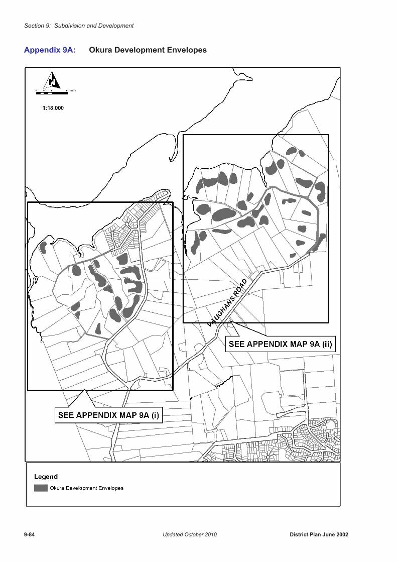
Section 9: Subdivision and Development
Appendix 9A: Okura Development Envelopes
9-84 Updated October 2010 District Plan June 2002
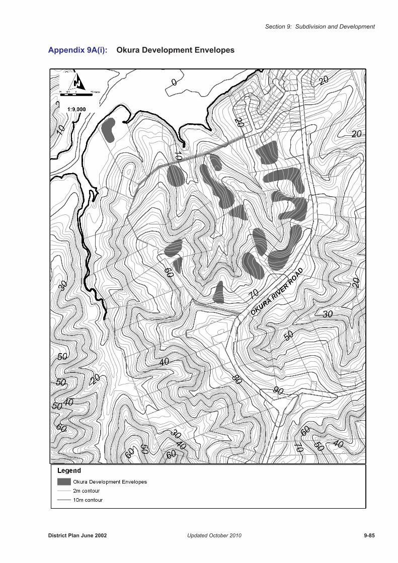
Section 9: Subdivision and Development
Appendix 9A(i): Okura Development Envelopes
District Plan June 2002 Updated October 2010 9-85
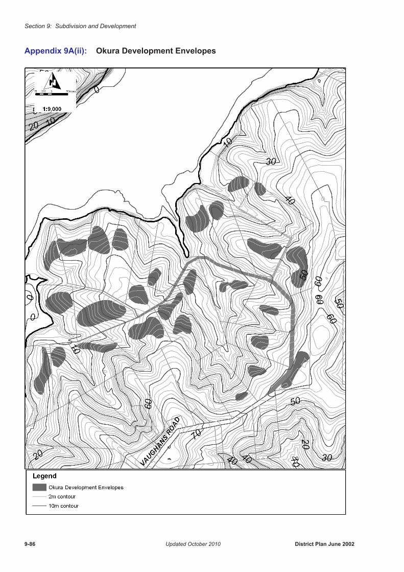
Section 9: Subdivision and Development
Appendix 9A(ii): Okura Development Envelopes
9-86 Updated October 2010 District Plan June 2002
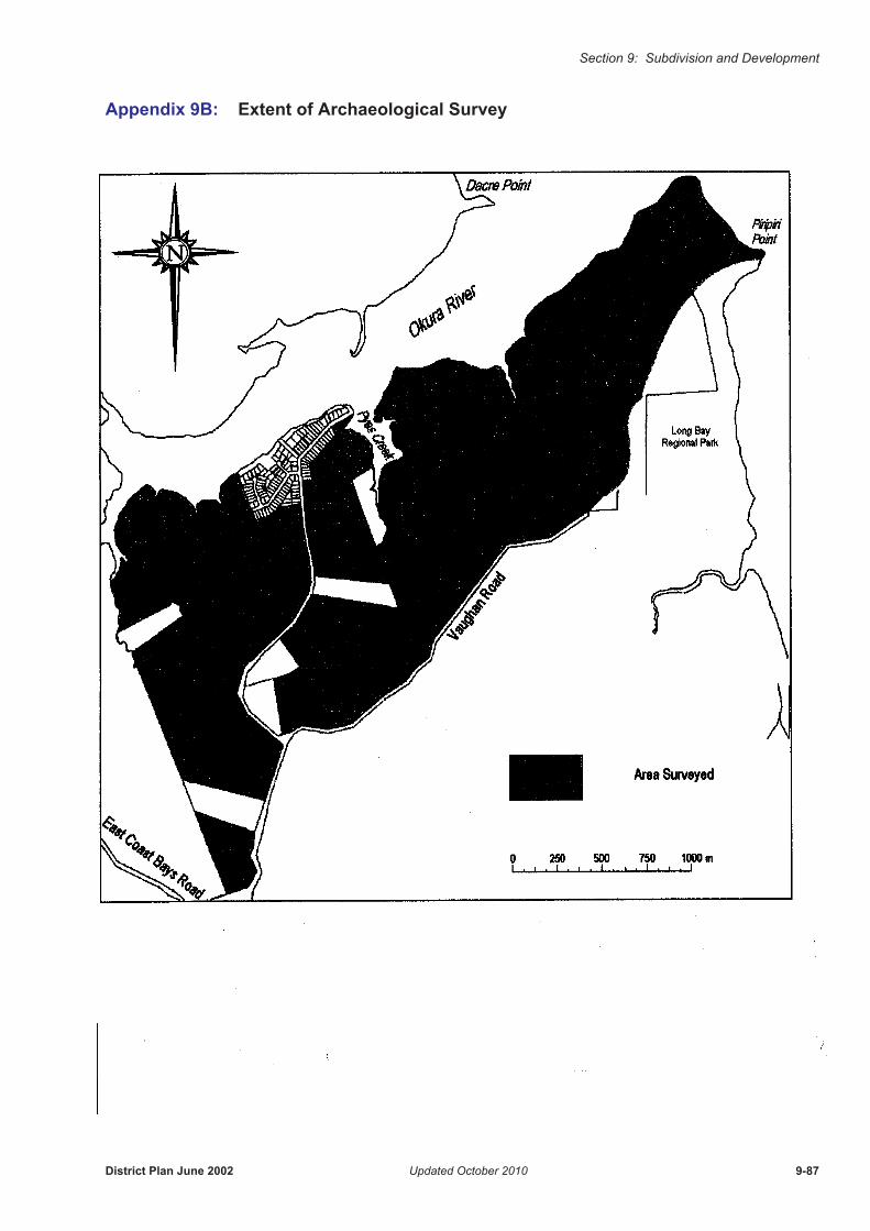
Section 9: Subdivision and Development
Appendix 9B: Extent of Archaeological Survey
District Plan June 2002 Updated October 2010 9-87

Section 9: Subdivision and Development
Appendix 9C: Guidelines for Protection of Areas of Native Bush Practice Note
Either:1. Minimum area of 0.7ha of continuous bush and exclusive of any building platforms;
and
a) being at least 50m width, and
b) with a canopy of 70% or more native vegetation component, and
c) with an understorey of 70% or more native vegetation component.
Or:2. Minimum area of 0.7ha of continuous bush and exclusive of any building platform,
and
a) abutting an area also covenanted or set aside as reserve, or
b) of special importance such as providing a habitat for a rare or interesting species of plant or animal, or
c) containing a geological or archaeological feature of importance.
9-88 Udpdated May 2008 District Plan June 2002