8: prime agricultural soils / soils of statewide importance · natural resource inventory (nri)...
TRANSCRIPT
Natural Resource Inventory (NRI) Franklin Township, Warren County, New Jersey
Prepared by Princeton Hydro, LLC 13 June 2007
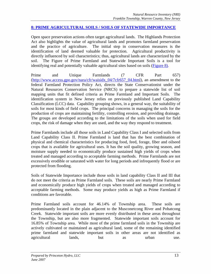
8: PRIME AGRICULTURAL SOILS / SOILS OF STATEWIDE IMPORTANCE Open space preservation actions often target agricultural lands. The Highlands Protection Act also highlights the value of agricultural lands and promotes farmland preservation and the practice of agriculture. The initial step in conservation measures is the identification of land deemed valuable for protection. Agricultural productivity is directly influenced by soil characteristics; thus, agricultural lands are characterized by the soil. The Figure of Prime Farmland and Statewide Important Soils is a tool for identifying real and potentially valuable agricultural sites based on soils (Figure 8). Prime and Unique Farmlands (7 CFR Part 657) (http://www.access.gpo.gov/nara/cfr/waisidx_04/7cfr657_04.html), an amendment to the federal Farmland Protection Policy Act, directs the State Conservationist under the Natural Resources Conservation Service (NRCS) to prepare a statewide list of soil mapping units that fit defined criteria as Prime Farmland and Important Soils. The identification system in New Jersey relies on previously published Land Capability Classification (LCC) data. Capability grouping shows, in a general way, the suitability of soils for most kinds of field crops. The principal concerns in managing the soils for the production of crops are maintaining fertility, controlling erosion, and providing drainage. The groups are developed according to the limitations of the soils when used for field crops, the risk of damage when they are used, and the way they respond to treatment. Prime Farmlands include all those soils in Land Capability Class I and selected soils from Land Capability Class II. Prime Farmland is land that has the best combination of physical and chemical characteristics for producing food, feed, forage, fiber and oilseed crops that is available for agricultural uses. It has the soil quality, growing season, and moisture supply needed to economically produce sustained high yields of crops when treated and managed according to acceptable farming methods. Prime Farmlands are not excessively erodible or saturated with water for long periods and infrequently flood or are protected from flooding. Soils of Statewide Importance include those soils in land capability Class II and III that do not meet the criteria as Prime Farmland soils. These soils are nearly Prime Farmland and economically produce high yields of crops when treated and managed according to acceptable farming methods. Some may produce yields as high as Prime Farmland if conditions are favorable. Prime Farmland soils account for 46.14% of Township area. These soils are predominantly located in the plain adjacent to the Musconetcong River and Pohatcong Creek. Statewide important soils are more evenly distributed in these areas throughout the Township, but are also more fragmented. Statewide important soils account for 16.85% of Township area. While most of the prime farmland soils in the Township are actively cultivated or maintained as agricultural land, some of the remaining identified prime farmland and statewide important soils in other areas are not identified as agricultural lands, but as urban use.

HUNTERDON COUNTY
WARREN COUNTY
M orris Canal ( Dry)
Pohatcong Creek
Pohatcong Creek
Mill BrookMontana Brook
Musc o netcong River
Bethlehem Township
Bloomsbury Boro
Hampton Boro
Greenwich Township
Washington Township
Harmony Township
BLOOMSBURY RD
MORRIS TPKE (RT. 57)
MOUNTAI N VIEW RD
GOOD S PRINGS RD
ASBU
RY-BR
OADW
AY RD
MAPLE AVE
MILLBROOK RD
MO NTANA RD
ANDERSON RD
BICKEL RD
WILLOW GROVE RD
HALFW
AY HOUSE RD
BUTLE
R RD
KITCHEN RD
BRY A N R D
MAIN S
T
SHIRTS RD
WHITE
S RD
SURRY LN
BUTTERMIL K BRIDGE RD
STE WARTSVILLE RD
HARLE Y CT
MOUNTAIN VIEW ROAD-WES T
EDISO
N RD
DIRT LN
HERLEMAN RD
HOFFMAN RD
STEEPLE CHASE
HALLS MIL L RD
WARN
E WAY
CLIF F SIDE DR
BEIDL
EMAN
RD
MICA MINE RD
INSCHO RD
WOOLV
ERTO
N RD
SECOND ST
THIRD ST
MORGAN RD
L EN A PE TRL
COPP
ERFIE
LD DR
NEW ST
YOLM
AN RD
CEME
TERY
HILL
RD
COLE
RD
RIDDLE CT
LIMEK
ILN RD
MULLER LN
WICKOFF CT
WATE
RBRO
OK DR
PRICE DR
EDISO
N RD
STEWARTSVILLE RD
White Township
Lopatcong TownshipFil
e: P:\
0420
\Proj
ects\
0420
006\G
IS\MX
D\Ag
_Soil
s.mxd NEW JERSEY COUNTY MAP
FIGURE 8STATE IMPORTANT SOILS
DE L A W
A R E
RIV
ER
OCEAN
MORRIS
SUSSEX
BURLINGTON
WARREN
MONMOUTH
HUNTERDON
BERGEN
MIDDLESEX
MERCER
PASSAIC
ESSEX
UNION
SOMERSET
CAMDENGLOUCESTER
HUDSON
SALEM
U 0 3,0001,500Feet
1 inch equals 3,000 feet
SOURCES:1. Parcel, roads and the Franklin Township Boundary data obtained from Warren County Planning Dept. "This map was developed using the Warren County New Jersey, Geographic Information System digital data, but this secondary product has not been verified by Warren County and is not county- authorized."2. Surface water data obtained from the NJDEP, Division of GIS.3. Soils data obtained from the USDA, Natural Resource Conservation Service (NRCS) website.
NATURAL RESOURCE INVENTORYFRANKLIN TOWNSHIP
WARREN COUNTY, NEW JERSEY
LegendCounty BoundaryMunicipal BoundariesPonds/Lakes
StreamsStreamsMorris Canal (Dry)RoadsParcels
PRINCETON HYDRO, LLC.1108 OLD YORK ROAD, SUITE 1RINGOES, NEW JERSEY, 08551
State Important SoilsAll areas are prime farmlandFarmland of statewide importancePrime farmland if drainedAreas not considered prime farmland