709 tabasco & chiapas - lonely planetmedia.lonelyplanet.com/shop/pdfs/mexico-12-tabasco... ·...
TRANSCRIPT
TAB
ASCO
& CH
IAPA
S
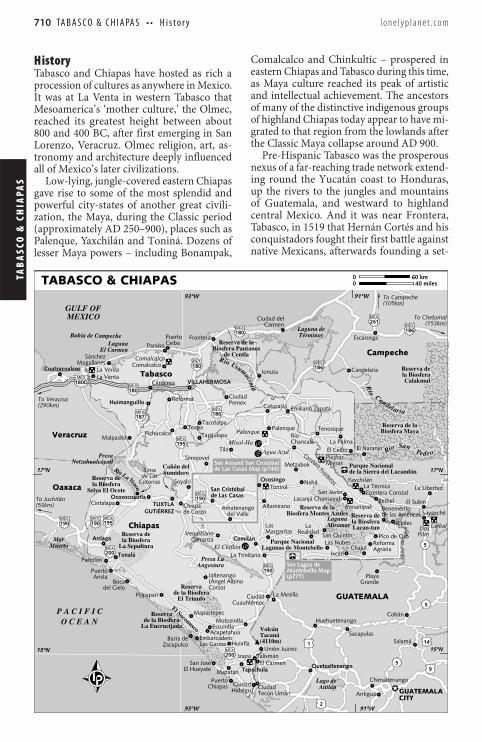
Mismatched siblings, the neighboring states of Tabasco and Chiapas are almost a study in contrasts. Smaller Tabasco – between central Mexico and the Yucatán Peninsula – is less diverse than Chiapas, and prone to flooding, as demonstrated by a catastrophic flood in October 2007. A largely flat, steamy, well-watered lowland, it sees fewer visitors, but those who do drop in discover a place with fascinating pre-Hispanic heritage from the Olmec and Maya civilizations, a relaxed tropical lifestyle and a unique environment of enormous rivers, endless wetlands and inviting beaches heading out into the Gulf of Mexico. In Chiapas, pine-forest highlands, wildlife-rich rainforest and well-preserved colonial architecture highlight a region of incredible variety. Palenque and Yaxchilán are evocative vestiges of powerful Maya kingdoms, and the presence of modern Maya is a constant reminder of the region’s rich and uninterrupted history. The colonial hubs of San Cristóbal de Las Casas and Chiapa de Corzo give way to fertile plots of coffee and cacao in the Soconusco, and for outdoor adventurers, excursions to Laguna Miramar and the Cañón del Sumidero are unmissable. Nature lovers willing to venture off the beaten track will swoon over the frothy cascades and exotic animals of the Lacandón Jungle.
Tabasco has mostly rebuilt and refortified since the 2007 flood submerged more than one-million homes and an estimated 80% of the state. Rains were unusually heavy that year, but the scale of the devastation underscored Tabasco’s continued vulnerability to seasonal rains and the general precariousness of its infrastructure. Though some preventative measures have been put in place since then, the region remains prone due to its many waterways, as evidenced by the 2009 flooding of Cárdenas and Huimanguillo, which displaced about 35,000 residents.
Tabasco & Chiapas
BIGGEST CITY: VILLAHERMOSA (POPULATION 673,000)
HIGHEST PEAK: VOLCÁN TACANÁ (4110M)
HIGHLIGHTS
Scale the jungly hills and soaring Maya temples of Palenque ( p752 )
Stroll the high altitude cobblestone streets of San Cristóbal de Las Casas ( p730 )
Cruise through the waterway and sheer high rock cliffs of the spectacular Cañón del Sumidero ( p730 )
Spend a few splendid days hiking and relaxing at the mountain-ringed Laguna Miramar ( p772 )
Admire the mysterious art of the ancient Olmecs at Villahermosa’s Parque-Museo La Venta ( p713 )
MiramarLaguna
SumideroCañón del
Villahermosa
de Las CasasSan Cristóbal
Palenque
709© Lonely Planet Publications Pty Ltd
TAB
ASC
O &
CH
IAPA
S TA B A S C O & C H I A PA S • • H i s t o r y l o n e l y p l a n e t . c o m
Chiapas
History Tabasco and Chiapas have hosted as rich a procession of cultures as anywhere in Mexico. It was at La Venta in western Tabasco that Mesoamerica’s ‘mother culture,’ the Olmec, reached its greatest height between about 800 and 400 BC, after first emerging in San Lorenzo, Veracruz. Olmec religion, art, as-tronomy and architecture deeply influenced all of Mexico’s later civilizations.
Low-lying, jungle-covered eastern Chiapas gave rise to some of the most splendid and powerful city-states of another great civili-zation, the Maya, during the Classic period (approximately AD 250–900), places such as Palenque, Yaxchilán and Toniná. Dozens of lesser Maya powers – including Bonampak,
Comalcalco and Chinkultic – prospered in eastern Chiapas and Tabasco during this time, as Maya culture reached its peak of artistic and intellectual achievement. The ancestors of many of the distinctive indigenous groups of highland Chiapas today appear to have mi-grated to that region from the lowlands after the Classic Maya collapse around AD 900.
Pre-Hispanic Tabasco was the prosperous nexus of a far-reaching trade network extend-ing round the Yucatán coast to Honduras, up the rivers to the jungles and mountains of Guatemala, and westward to highland central Mexico. And it was near Frontera, Tabasco, in 1519 that Hernán Cortés and his conquistadors fought their first battle against native Mexicans, afterwards founding a set-
�
������
�� ������
����������
�������
���������� ��
������������
������������(290km)
To Veracruz
(53km)To Juchitán
(105km)To Campeche
(153km)To ChetumalMEXICO
GULF OF
TérminosLaguna de
O C E A NP A C I F I C
Bahía de Campeche
ordePnaSoíR
atni
ca
musUoíR
airalednaC
oíR
Oaxaca
Veracruz
Chiapas
Tabasco
Campeche
CITYGUATEMALA
Lacanjá Chansayab
CeibaPuerto
Tacotalpa
RealidadLa
Nahá
Metzabok
Las NubesSan Quintín
Tapijulapa
El Ceibo
La Técnica
de CorzoChiapa
Malpasito
Jonuta
MagallanesSánchez
GrandePlaya
Tapachula
Corzo)(Ángel AlbinoJaltenango
de las AméricasBenemérito
Unión Juárez
Tecún UmánCiudad
CarmenCiudad del
CuauhtémocCiudad
Emiliano ZapataPemexCiudad
AgrariaReforma
Pico de OroMargaritasLas
ChancaláRío
TilaSimojovel
del ValleAmatenango
CarranzaVenustiano
de Las CasasSan Cristóbal
Soyaló
GUTIÉRREZTUXTLA
HidalgoCiudadChiapas
Puerto
El HueyateSan José
Las GarzasEmbarcadero
ZacapulcoBarra de
del CieloBoca
AristaPuerto
VILLAHERMOSA
Escárcega
Candelaria
Catazajá
Frontera
Pichucalco
Mazatán
Acapetahua
Motozintla
Huixtla
Escuintla
Mapastepec
Pijijiapan
San Javier
ChajulIxcán
La Palma
Paraíso
AltamiranoCintalapa
ParedónLa Trinitaria
TenosiquePalenqueTeapa
Reforma
Comalcalco
CárdenasLa Venta
Ocozocoautla
Huimanguillo
Comitán
Ocosingo
Tonalá
Arriaga
Coatzacoalcos
Cobán
SalamáSacapulas
La Mesilla
El Carmen
La Libertad
Sayaxché
El Subín
El Naranjo
Pipiles
Bethel
Huehuetenango
Chimaltenango
Antigua
Quetzaltenango
Talismán
Frontera Corozal
Cotorrasde LasSima
La Venta
Comalcalco
Izapa
Yaxchilán
Bonampak
Palenque
Toniná
Lacan-tunla BiosferaReserva deBiosfera Montes Azules
Reserva de la
Lagunas de MontebelloParque Nacional
La Sepulturala BiosferaReserva de
Selva El Ocotela BiosferaReserva de
de la Sierra del LacandónParque Nacional
Calakmulla BiosferaReserva de
Biosfera MayaReserva de la
La Encrucijadade la Biosfera
Reserva
El Triunfode la Biosfera
Reserva
(4110m)TacanáVolcán
91ºW93ºW
17ºN 17ºN
15ºN15ºN
91ºW93ºW
MiramarLaguna
atne
VaLoíR
AtitlánLago de
AngosturaPresa La
MuertoMar
NetzahualcóyotlPresa
El CarmenLaguna
SumideroCañón del
El Soconusco
Agua Azul
Misol-Ha
GUATEMALA
CeibalPilasDos
NegrasPiedras
de CentlaBiosfera Pantanos
Reserva de la
El Chiflón
(p771)Montebello MapSee Lagos de
de Las Casas Map (p744)See Around San Cristóbal
MEX
MEX
MEX
MEX
MEX
MEX
MEX
MEX
MEX
MEX
MEX
MEX
MEX
MEX MEX
MEX
MEX
187
14
5
1
9
2
5
5
200
180D
186
180
186
261
186
180
200
190
180
190
190 195
195
190
Fronteriza
Carretera
TABASCO & CHIAPAS 0 60 km0 40 miles
710