6.4 land drainage - province of manitoba · permanent marshes, without outlets, ... the manning...
TRANSCRIPT

62
6.0 Infrastructure Development
6.4.1 Above: Early DrainDetail of a map dated January 1, 1882, showing some of the first drainage projects in the study region,involving the Roseau River, Mosquito Creek and the Seine River. (Map Title: Map of the Province of Manitoba,Canada Complied from Government Surveys to Jan 1, 1882 Source: PAM # H3 614.2 fbo 1882R c.1. HRB Map #009.)
6.4 Land Drainage & Ground WaterPoor drainage has always been a major problem in the study region. It confronted and defeated some of the first
settlers during the 1870s, and for many years prevented widespread settlement of the Red River Valley, despite therichness of its soil and the ease in which the open prairie grasslands could be broken and cultivated. The long-standingproblem of land drainage existed for several reasons.
The many creeks and rivers flowing from the highlands in the eastern part of the region regularly spilled their banksduring the annual spring melt, flooding the farmland on the 'flats' in the western part of the study region. Due to theextreme flatness of the land in the Red River Valley, and the impervious nature of the clay subsoil, this water tended toremain on the surface, and only very slowly drained away or evaporated. Such waterways, which flowed into semi-permanent marshes, without outlets, were known as ‘blind creeks’ and there were a number of them in the study region.Drainage ditches and canals were constructed in the valley by the early 1880s, and these initially succeeded in drainingoff much of the excess surface water. The Manning Canal, in particular, constructed in 1906-08 in the area south of theSeine River, facilitated the draining of several large permanent marshes in that area. Some of the earliest drainageprojects involved the Seine River and Mosquito Creek near St. Malo, and the 'flats' south of Dominion City.
However, as new farms were cleared and roads constructed in the hitherto undrained territory of the eastern highlandregions, more and more runoff was directed into the upstream drainage canals, overloading them and choking them withsilt and vegetation. Eventually, even a heavy rainfall could cause flooding and serious crop damage for farmers living inthe valley. Frustrated farmers sometimes banded together to dam some of the canals, which caused even more floodingupstream. Court cases, claims, counter claims, and some "bad blood" between neighbours and municipalities resultedfrom the region’s drainage problems.
Beginning in the late 1950s, the provincial government became heavily involved with the issue and commenced workon several cost-shared drainage projects in three separate drainage districts in the study region. These included theManning and Tourond canals, and the Youville and Jenson Drain in the northern part of the Study Region. In 1958 theSeine River Diversion was dug and this alleviated some of the problems associated with springtime flooding along theSeine River. During this period a new type of drainage ditch was instituted; instead of building deep ditches with steepsides, the new ditches were built shallower, wider, and with gently sloping sides. This prevented rapid silting and allowedthe edges to be cut for hay, keeping the channels clear of undergrowth. Currently, an intricate matrix of canals, ditchesand shallow run-off channels, constructed and maintained by provincial and municipal levels of government and individualfarmers, keeps the land well drained and crop damage due to flooding at a minimum.
GroundwaterIn addition to drainage problems, the entire Red River valley also suffers from poor ground water resources. Early
settlers put down crib wells up to 15-18 metrs (50-60 feet) depth without striking water, and when ground water wasreached, it was invariably alkaline and unfit for domestic use. Many of the early settlers were forced to haul water from thecreeks flowing off the highland areas. Mosquito Creek, in the southern portion of the study region, was a common sourceof drinking water for many years. Another significant source of drinking water was the Springbank Well, located 4 km (21/12 miles) south of Ridgeville. Spring-fed, it was discovered accidently on the public road allowance by an early settler,Hamilton Stewart. As the lands west of the well became more settled, the demand for water from this source becamemore acute, and it was enlarged and improved several times over the years. It was said that every farmer west of the wellhad to haul water from it for their stock during the winter months. Some days there would be half a dozen sleds with tankswaiting their turn at the well. The Springbank Well is still in use, though it is now housed and protected within a municipalstructure, and the water is easily obtained by use of an electric pump and overhead hose. However, in recent years, withthe increased use of farm dugouts to collect and store rainwater, it is no longer a critical source of drinking water. Similarsituations occurred throughout the study region. The Clearsprings Settlement, located just north of Steinbach, wasestablished during the mid 1870s, and is so named because of the existence of another all-important flowing spring. Whilethe eastern highland is blessed with excellent well water, the Red River flats is equally hindered by a lack of it. Thuswater, both surface and groundwater have long played an important role in the history and development of the studyregion.
Sites noteworthy for their portrayal of water resource themes include:1. The Manning Canal2. Seine River Diversion3. Dominion City area drains

63
6.4.3 Above: Drainage Canals in the Niverville areaDetail of a 1922 Sectional map showing some of the early major drainage canals in the Niverville area. Note howthe Manning Canal follows the natural NE/SW slope of the land while the two canals to the south of it follow the E/Wroad allowances. (Map Title: Sectional Map No. 23, Emerson Sheet, March 1922 Source: Maps & Surveys Branch files. HRBMap #035d.)
6.4.2 Above: The Manning CanalWhile most of the major drainage canals and drains are significant to the history and development of theregion as a whole, one stands out above the others. The Manning Canal made possible the draining of two ofthe three large marshes formerly located in the Seine River area, as well as providing an outlet for the ‘blindcreek’ northwest of Steinbach. A short 5-km (3-mile) long ditch, connecting the Seine River channels betweenSte. Anne and Dufresne, helped to drain the “Great Marsh’, the third largest wetland in the area. Interestingly,the routing and configuration of the Manning Canal appears to retrace the route of the former ‘Oak River’portrayed on some early maps of the area. The Seine River Diversion connects with the Manning Canal nearIle des Chênes, near the site where the old Ste. Anne Trail crosses the Manning Canal. This strategicallylocated site possesses several elements related to land drainage and provides an excellent potential roadsidestop where drainage could be interpreted as a major landscape element. (Photo: Historic Resources Branch.)
6.4.4 Right: Drainage Ditches in theEmerson 'Flats' AreaDetail of a map, printed in 1883, showing alarge number of government and farmer builtdrains in the ‘flats’ area between DominionCity and Ridgeville. Note also the railway spurline, which existed at this time, connecting thesiding at Dominion City with the temporarygravel pits developed in section 16. (MapTitle: Map of Part of Franklin Municipality ShewingDrains Etc, January 1883. Source: PAM#: H9614.21 Fr gbbd 1883. HRB Map #025.)
6.0 Infrastructure Development
6.4.5 Left: Drainages and DugoutsDetail from the Emerson topographic mapsheet showing some of the drainages and themany farmyard dugouts in the Fredensthalarea. Note the only areas of survivingwoodland are on the ridge just south ofRidgeville. (MapTitle: Emerson 62H/3 1:50,000topographic map, 1991 edition).

64
7.0 AGRICULTUREGiven the nature of the region’s natural resource base, the history of resource use in the Crow Wing Study Region is
primarily that of agriculture. During the early decades after settlement there also was a fairly active, if short-lived, wood andlumber trade centred in the Emerson and Dominion City areas. Dominion City also possessed a brick-making plant during theearly 1880s. In more recent years, the mining and transportion of gravel resources has become an important industry inselected areas of the upland district. Despite these other types of resource use, agriculture always has been the region'smain economic activity. There has been great diversity within the region's agricultural history, including a variety of crop andlivestock production. Cereal crops such as wheat, oats, and barley; specialty crops, such as sugar beets, sunflowers, andpotatoes; dairy products, such as milk, butter, and cheese; intensive poultry and hog production; and more recently, severalexotic livestock species such as bison, ostrich, and emu are all part of this diversified agricultural economy.
Agricultural land use in the study region has always been influenced by two basic geographic factors: firstly, landquality and soil type, and secondly, its proximity to the Winnipeg urban market. Farmland located on the flats of the RedRiver valley traditionally has been used for cereal grain production, while the poorer quality land in the eastern highlandsalways has had a livestock emphasis, with beef production dominating the southeastern areas, and dairy productiondominating the northeastern areas. Changes in agricultural production have largely been determined by technologicaladvances in farming practices and equipment. This resulted in larger and larger-sized farm holdings in the western ‘cropproduction’ half of the study region, and increasingly more numerous and mechanized feed-lot-style dairy, poultry, hog, andbeef operations in the eastern ‘livestock’ half of the study region.
The southern districts of the study region, particularly in the vicinity of Emerson and Dominion City, were among theearliest areas of Manitoba, outside of the confines of the Red River Settlement, to be settled. By 1873 the surveying of theland in the Red River valley had been completed, and settlers (primarily from southern Ontario) were beginning to arrive viasteamboat on the Red River, or by the more grueling Dawson Route from Lake Superior. Mixed farming initiallypredominated, but by 1900 advances in farm equipment design permitted the cultivation of larger acreages, and cash cropproduction soon began to take hold. This was reinforced by the establishment of many communities in the region wheresupplies and foodstuff could increasingly be purchased, rather than having to be raised or produced on the farm. Thus by theearly 1900s, agricultural specialization was becoming commonplace.
In 1874 the Mennonite East Reserve was established in the study region. With their experience of settling andfarming the open steppes of southern Russia, the Mennonites did not hesitate to establish villages and farm the open prairie.As in the areas of early Anglo-Ontarian settlement, mixed farming initially predominated in the East Reserve. Before long,however, cash-crop production developed in the area below the ridge, and dairy production prevailed in the poorer qualityland above the ridge. The close proximity of Winnipeg permitted daily transport of milk and cheese products to the rapidlygrowing Winnipeg market, and permitted intensive agricultural production on land which would not have supported this levelof development had it not been located so close to Winnipeg. After the turn of the century, rapid population growth in thestudy region led to farm diversification; particularly in the Mennonite-settled areas. Rather than relocating to the fewremaining sparsely settled areas of the province where land intensive cash crop production could be carried out the newgeneration of Mennonite farmers instead shifted to more building-intensive operations; such as poultry and hog production,and thus were able to remain in their home region. As a result of this early shift to specialized, intensive, agriculturaloperations, this region of Manitoba came to possess the highest density of rural population in the province.
There are very few agricultural sites in the region currently being preserved, conserved, or commemorated becauseof their portrayal of the region’s rich agricultural heritage, despite the importance of the agricultural sector in the developmentof the study region. Additionally, and unfortunately, there appears to be only a small number of known surviving sites whichcould be developed as heritage landmarks, commemorating and celebrating is component of the region's heritage.
7.0.1 Right: Farmland For Sale, 1899This map detail shows land for sale in the Red River valley in 1899, before many of the largerdrainage projects were undertaken. It shows a tremendous amount of land for sale, including bothquarter sections and river lots. Schools are shown on this map, (+), which is helpful, since theirpresence indicates whether an area was truly settled, and the land not just alienated from the Crownand lying unused. By the time this map was produced, in 1899, some of the province's earliestdrainages had been constructed in the area south of Dominion City. This fact is reflected on this mapby the small amount of land for sale and the presence of several schools in this district. Also ofinterest is the lack of any land for sale in the Mennonite East Reserve district.(Map Title: Map Showing Lands For Sale in the Winnipeg District and the Far Famed Red River Valley ofManitoba. Source: The Historical Atlas of Manitoba, by Warkentin and Ruggles for the Manitoba HistoricalSociety, 1970, page 496. HRB Map #079.)

65
7.0.2 Above: Agricultural districts of southern Manitoba, 1970
Map legend:1: Livestock Specialty - Dairying 5: Mixed Farming - Cash Crop Emphasis2: Livestock Specialty - Beef Raising 6: Mixed Farming - Livestock Emphasis3: Grain Specialty - Mixed Grain 7: Specialty Crops - Sugar Beets, Sunflower, etc4: Grain Specialty - Wheat 8: Specialty Crops - Market Gardening
Detail of a map produced by Thomas Weir in 1960, showing the distribution of agricultural types in southern Manitoba.Note that in the Red River valley cereal-grain production dominates (zone 5), while in the more marginal 'highlands' eastof the valley, the emphasis is on livestock production. Within this eastern livestock zone, dairying predominates in thenorthern half (zone 1) while beef production is emphasized in the southern half (zone 2). The land quality in thisnortheastern district is much the same as in the southeastern portion. However, the proximity of the district to theWinnipeg urban market makes dairy production, with daily delivery of fresh milk, possible. At greater distances, theincreased cost and time factors makes dairy production less profitable. (Map Title: Manitoba Types of Farming, EconomicAtlas of Manitoba, Province of Manitoba Department of Industry and Commerce, page 41. HRB Map #077.)
7.1 Mixed Farming
Initially, small scale mixed-farming operations predominated throughout the study region; even in the RedRiver valley. Homesteaders kept a quantity of hogs, cows, and chickens, etc. for their own use, and for barter inthe local grocery stores. The introduction of steam tractors and mechanized field work, during the 1890s,permitted the cultivation of larger acreages by individual farmers, and a greater emphasis on cash crop productionsoon took hold. Some farm livestock continued to be raised, particularly in areas nearer to the railway lines, andthe daily shipment of milk, cream, eggs, and poultry to nearby Winnipeg continued for years, providing a welcomesource of extra income. Mixed farming in the Red River valley completely disappeared during the rapidmechanization and expansion of farm operations of the 1950s and 1960s.
In the eastern highlands, where the soils were of inferior quality and much of the land was strewn withstones and boulders, crop production was limited and difficult, hence, mixed farms and horsepower prevailed intothe early 1950s. In this mixed-farming zone, beef production was predominant in the more southerly areas, while,because of its proximity to Winnipeg, mixed farming with a dairy emphasis developed in the northeastern areas.Currently few farms include a wide variety of crop and livestock production types. Today’s mixed farmers aregenerally involved in one type of livestock and only one or perhaps two crop types. Long gone are the truly mixedfarms where one would find cows, horses, chickens, hogs, and poultry, along with a mix of pasturelands andcereal crops. Also long gone are the ‘old-style’ prairie farmsteads featuring the classic red hip-roof barn, a varietyof little wooden outbuildings, and an attractive old-style farmhouse.
7.1.1 Left and below: Mixed farmingEarly scenes of domestic livestock on farmsin the study region. Until the late 1940s mostfarm families raised a variety of farmyardanimals and poultry for personal use andcash sale. Currently, such a variety offarmyard animals only can be found on thedistrict’s hobby farms. (Source: Penner, Lydia.Hanover: One Hundred Years, Published by theR.M. of Hanover, Derksen Printers, Steinbach,MB, 1982.)
7.0 Agriculture

66
7.2 Cereal Crop Production
During the early 1870s the areas to the east and southeast of Winnipeg were quickly filled with settlers,mostly of Anglo-Ontario, British and Scottish origins. French-speaking settlers didn’t begin to arrive in largenumbers until the late 1870s, and they tended to select areas near the Seine and Rat rivers. Despite some wetyears and crop failures, cereal grain production soon flourished in these areas, and land prices rose continuously,reaching $60.00 an acre in some locales by 1881. As in the poorer, highland areas of the region, settlers in theRed River Valley initially established mixed farms, where most of the food could be produced on the farm. Ascommunities were established and grew, commercial supplies of foodstuffs led to fewer mixed operations andmore specialization in cereal corps.
However, commercial crop production, however, soon fell on hard times in many areas of the studyregion. After the ‘Bust of 1882’, many settlers and farmers in the study region lost their farms when outrageouslyhigh land prices suddenly crashed, and taxes and debt payments proved unaffordable. Vast amounts of land inthe valley were taken over by the municipalities, and sold in tax sales. Much of this land was purchased by foreigninvestors and held in speculation, resulting in huge amounts of farmland left unbroken and uncultivated for manyyears. Additionally, as land in the poorly drained valley flats and in the eastern highlands continued to be drainedand cleared, the problem of flooding and poor surface drainage was compounded, as existing rivers and newly-dug ditches soon became overburdened causing additional flooding in some areas. Most of Township 7 Range 4East, southeast of Niverville, remained unsettled for over 30 years, until 1906, when major drainage works in theregion, including the Manning Canal, finally permitted the establishment of grain farms in the area. As theproblem of surface drainage was reduced after the turn-of-the-century, grain production increased substantiallyand soon wooden grain elevators were erected at almost every rail siding in the Red River valley. Oncecommonplace, these early-style wooden grain elevators are virtually all gone, except for two operational elevatorsat New Fredensthal and Dufresne, and an abandoned structure located in Ridgeville. Grain is now hauled toinland terminals, such as those at Letellier, St. Jean-Baptiste, and Morris, located along railway lines west of theRed.
7.2.1 Below left: Western Canada’s First Grain ElevatorConstructed in 1879 in Niverville by William Hespeler, this unusualround structure was western Canada's first commercial grainelevator. In operation until 1924, it had a capacity of 25,000bushels and featured horse-powered grain-handling equipment. Itwas constructed from timbers brought by riverboat from Moorhead,Minnesota. Niverville was laid out by Mr. Hespeler as a railwaytown and was intended to be a service centre for the entireMennonite East Reserve. However, because Niverville wasseparated from much of the East Reserve by extensive sloughs,Hespeler's vision did not become a reality, and by 1900 Steinbachhad established itself as the leading business and service centrefor the East Reserve. (Photo: Provincial Archives of Manitoba.)
7.2.2 Left: End of an EraPhoto of the demolition of Dominion City's lastgrain elevator in 1999. As with most of therailway communities located along the Pembinabranch line, Dominion City at one timepossessed a line of several 'standard plan'wooden grain elevators. (Photo: John Lehr.)
7.2.4. Right: Harvest timeCombines are hard at work takingin wheat crop during the 2002 fallharvest near St. Pierre-Jolys.(Photo: Historic Resources Branch.)
7.2.3 Right: Ridgeville ElevatorThis abandoned grain elevator inRidgeville is the last of the early'standard plan' wooden grainelevators still in existence in thestudy region. (Photo: HistoricResources Branch)
7.0 Agriculture
7.2.5. Left: Dufresne ElevatorAlthough of relatively recentconstruction, the Dufresne grainelevator is significant since it is thefirst elevator visible to westboundtravelers on the Trans CanadaHighway. (Photo: Historic ResourcesBranch.)

67
7.3 Bonanza Farms
Around 1910, a group of Americans, mostly from Illinois, bought large amounts of the uncultivatedfarmland west of Arnaud and north of Dominion City. Some of the prominent names who financed these “bonanzafarm” projects were Henry H. Lyman with 12,000 acres (5,000 ha); and H.L. Emmert with 35,000 acres (15,000ha). Others included Messrs Fisher, Guthrie, Saunders, and Young, each with farms in the 6,000-acre (2,500 ha)range. The Lyman operation consisted of five separate ranches, each with a hired foremane. Each ranch had itsown complex of buildings consisting of a large 8-10 room house for the foreman, bunk houses for the hired men,horse, cattle and hog barns, machine storage buildings, and repair and blacksmith shops. In 1920 the LymanBonanza Farm equipment inventory consisted of 27 tractors, 4 threshers, 35 binders, seed-drills, and otherequipment in proportion. Each ranch also had ample storage bins for grains, and at least one boasted a full-sizedgrain elevator. The land on the Lyman Farm was broken using ‘Big-4’ gas tractors. Many people visited theranches simply to get a glimpse of these giant machines. Such equipment was too expensive for the averagehomesteader to purchase. After farming the land for a number of years these bonanza farm operations weregradually broken up in the mid 1920s. Much of the land in these ranches was sold to the Mennonite Board ofLand Settlement who were seeking settlement areas for Mennonites newly arrived from Russia, and for theyounger farmers from the older settled areas where land was no longer available. With continued diligenceconcerning the drainage networks in the Red River valley, crop production continues to dominate on the RedRiver valley flats. Unfortunately, there are no preserved sites associated with the region's former bonanza farmscurrently preserved or commemorated by historic markers. The existence of these farms is preserved only inshort passages in one or two local history books.
7.0 Agriculture
7.3.1 H.H. Lyman Bonanza FarmA selection of archivalphotographs showing some of thestructures and scenes from thehuge Lyman Farms operationwhich existed in the Arnaud districtduring the first two decades of thetwentieth century. Virtually alltraces of this, and several other,even larger, bonanza farmoperations in the study region,have disappeared from thelandscape. (Photos: from ArnaudThrough The Years, published by theArnaud Historical Society 1974.)

68
7.4 Dairying
The dairy industry established itself in both the French settlements along the Seine River, and in the villages of theMennonite East Reserve. The lush natural grasslands in the area of the lower Seine River provided rich grazing lands for cattleherds. Similar physical conditions in the area along the Rat River, particularly the St. Pierre-Jolys, La Rochelle, and St. Maloareas, also prompted the establishment of several early dairy and cattle operations.
Cheese was the main dairy product produced during the 1880s. Due to an under-developed transportation system,daily milk delivery to Winnipeg was not possible at the time, and cheese could be more easily stored and transported. By 1900,there were cheese plants in at least eight locations occupying a broad band from Giroux to Grunthal. Grunthal also possessedone of the only creameries in the region.
Winnipeg at this time was growing rapidly, and the demand for butter, cream, and milk increased with the population.In 1898, the Canadian Northern Railway constructed a line southeast from Winnipeg, crossing the Seine River at Ste. Anneand continuing to the American border near Piney. This development prompted increased herd sizes and a move to producingbulk milk by area farmers. The new railway line, and Winnipeg’s milk requirements, prompted a rapid rise in local land pricesas well.
With the local supply of milk increasingly being diverted to Winnipeg, the region’s cheese plants began to close due toa lack of milk. By 1914 they all had ceased operations. Other factors leading to their closure included increased demand forbeef products after 1900. Alsol, the European market for Canadian cheese was being increasingly met by the dairy farmers ofQuébec and Ontario, who were closer and therefore could provide a cheaper product.
Around 1914, Blumenort developed as a collection point for the daily shipment of milk from Mennonite areas toWinnipeg via the railway connection at nearby Giroux. Giroux was a major a major staging area for the shipment of dairyproducts from 1898 until the trucking of milk began in 1927. Butter and sweet cream began to be produced in Grunthal in 1927and in Steinbach in 1929. Soon after, the milk-receiving station at Giroux was moved to Seinbach, and the delivery of dairyproducts thereafter was increasingly handled by trucks.
During the ‘Dirty Thirties’ cheese production resumed. Cereal crop production was no longer economical, or evenpossible in most areas of the prairies. In order to survive, several means of alternate production were tried by the region’sfarmers; including cheese production. The move proved to be very successful and by 1936, cheese again was ‘King’ in theregion. Of Manitoba’s 21 producing cheese plants at the time, 17 were located in the study region. The importance of dairyingcontinued in the region, peaking in 1950, when it produced the bulk of Manitoba’s cheese and half of Winnipeg’s milk andsweet cream. Soon after, and for a second time, the bubble burst for the region’s cheese producers. During the early 1950s,the growing baby boom in Winnipeg and throughout Canada prompted a switch to fluid milk production, and without a constantand secure supply of milk, the cheese plants began to close. By 1958 only Grunthal and New Bothwell were producing cheese.While no new cheese plants have been established since that time, these two plants continue to operate, and carry on theregion’s proud tradition of cheese making. The remainder of the region’s dairy producers now are involved in bulk milkproduction, which by the early 1960s became fully mechanized.
Dairy production in the study region developed because of the rich grazing lands of the region, but it survived becauseof the close proximity of Winnipeg. This was particularly so in the Mennonite areas. With fairly rapid population growth afterthe turn of the century, the area’s farmers turned to intensive farm diversification in the home region, rather than moving tonew, sparsely settled areas of the province. There was a trend to more building-intensive operations such as dairying, poultry,and more recently, hog production. Because of this shift to smaller farm unit sizes, with highly mechanized, building-intensiveoperations, this region now possesses the highest density of rural population in all of Manitoba. The close proximity ofWinnipeg permitted daily transport of dairy and livestock products to the rapidly growing Winnipeg market, and therebypermitted intensive agricultural production on land which would not have supported this level of development had it not been soclose to Winnipeg.
Sites relating to dairying:Wooden silo at St.Pierre-JolysHolstein cow mascot at La BroquerieSurviving example of early dairy barns
7.0 Agriculture
7.4.1 Daily Delivery Milk ShedsA map showing the dairy milk shed and milk-processing plants in southern Manitoba around 1960. The greenareas denote sources of daily bulk milk delivery. Note that the entire northern half of the study region isincluded in the Winnipeg milk shed. (Map Title: Milk Processing Plants. The Economic Atlas of Manitoba by T.R. Weir,1960. Plate 21, page 47. HRB Map #076.)
7.4.2 The Dairy LandscapeThe continued importance of the dairyindustry in the study region is shown bythe presence of feed silos on the skylinethroughout the northern portion of theregion. (Photo: Historic Resources Branch.)

69
7.4.5 Above: Dairy Industry Signosts – BarnsA 1960s-era dairy barn complex located on the southern outskirts of Ile des Chênes. While it isclear that this dairy farm no longer functions, the structure continues to be maintained in goodphysical condition. (Photo: Historic Resources Branch.)
7.4.4 Above: Dairy Industry Signposts – BarnsView of a large, 1940s-era, dairy barn near La Broquerie, with cattle grazing along thebanks of the Seine River; a sight common to the daily delivery 'milk shed' areas of thestudy region. (Photo: Historic Resources Branch.) 7.4.6 Above: Dairy Industry Signposts – Holstein Statue
La Broquerie's 'town mascot', a larger-than-life Holstein dairy cow. Such community statues are fairlycommon in Manitoba communities. La Broquerie is the only community to commemorate its dairyingheritage in such a manner. (Photo: Historic Resources Branch.)
7.4.3 Below: Dairy Industry Signposts - SilosThis timber silo in St. Pierre-Jolys area is likelythe oldest in the study region. Unfortunately it isin rapidly deteriorating condition. (Photo: HistoricResources Branch.)
7.4.7 Above: Metal and Concrete – A Sign of the TimesA large modern dairy operation located near Blumenort featuring a connected complex of metal buildingsand silos. Such 'feedlot' dairy operations, where the cattle are housed almost year-round within such largestructures, are quickly replacing the more traditional dairy barn and grazing pasture type of operations.(Photo: Historic Resources Branch.)
7.0 Agriculture

70
7.5 Sugar Beets
The production of specialty crops in the Red River Valley began during the greatdepression of the 1930s. Farmers engaged primarily in grain production had an especially hardtime contending with drought, grasshoppers, and low prices. To save the family farm, a widevariety of different crops were tried, including corn, beans, potatoes, strawberries, andraspberries. Some farmers tried specializing in hogs and poultry, but with prices at only three tofive cents a pound, returns were too low to meet production costs. Many farmers simply gave upfarming entirely.
With the onset of World War II and rationing, sugar became an increasingly scarcecommodity. In 1940, a group of 15 Steinbach-Giroux farmers tried growing sugar beets. Soiland moisture conditions in that area proved well suited to the crop, and it soon was shown to bea profitable cash crop. Many different areas of the province were then tested to establish wheresugar beets could be grown most advantageously. The eastern part of the Red River valley wasfound to be one of the best areas, and before long, beet loaders were installed at almost everyrailway station along the C.P.R. track between Emerson and Winnipeg, and a large processingplant was constructed in Winnipeg. Because of the highly labour intensive nature of the crop,first acreages were small, averaging only 2 to 5 ha (5-10 acres). However, as more mechanizedproduction techniques were developed, average field sizes increased to 16 ha (40 acres) by the1960s, and 40 ha (100 acres) by the 1970s. The Manitoba Sugar refinery was purchased byRogers Sugar during the early 1990s, and in 1996 the company consolidated operations aroundits plant in southern Alberta. The Manitoba plant was closed, and after almost 50 years ofoperation, the entire Manitoba sugar beet industry came to an abrupt end.
Since beet growing in the early years required substantial manual labour, it waswelcomed by those who were interested in maintaining the family farm, since it provided workfor the children, and helped to slow the exodus of rural youth to urban centres. During the earlyyears most of the work had to be done by hand: hoeing, thinning, wind-rowing, topping, andeven loading using the locally-famous "beet fork". Also, during the late 1940s and early 1950s,anyone who had a beet contract could apply to the Department of Immigration for labourersfrom the war-torn areas of Europe. Thousands of immigrants were able to find new homes inCanada as a result. Their contract required that they would stay on the farm for at least oneyear or the length of the beet season.
As with the former bonanza farm operations in the study region, the existence andimportance of cash crop sugar beet production in the study region is now but a memory, and asyet, has not been commemorated or interpreted, except for brief passages in local communityhistories.
7.0 Agriculture
7.5.3 Left: Hoeing and thinningsugar beets, c.1955Initially, sugar beet production washighly labour intensive and beethoeing was an opportunity for localyouth to earn some cash. By the mid-1970s, herbicides and mechanicalthinners made hand labour largelyunnecessary. . (Photo: Arnaud ThroughThe Years, published by the ArnaudHistorical Society, 1974.)
7.5.2 Above: Sugar Beet TrainsLoaded trucks waiting for their turn to unload beets onto the waiting rail cars inArnaud; early-1950s. Sugar beet loaders were located in both Arnaud and Dufrostas early as 1946. (Photo: Arnaud Through The Years, published by the Arnaud HistoricalSociety, 1974.)
7.5.4 Right: Sugar beet harvestingin the 1970s(Photo: Arnaud Through The Years,published by the Arnaud Historical Society,1974.)
7.5.1 Below: Sugar Beet ProductionSelected views from the four-decadeperiod during which sugar beetproduction provided a valuable cashcrop alternative for many of the cerealcrop growers of the Red River Valley.These photos were first published inthe Arnaud community history book.The scene below shows John Janzenon a pony tractor cultivating a sugarbeet crop on his father’s farm. (Photo:Arnaud Through The Years, published bythe Arnaud Historical Society, 1974.)

71
7.6 Potatoes
The history of potato cultivation, in what is now southern Manitoba, stretches back 200 years to the earlydays of the fur trade. Similar to several other types of local agricultural produce such as wheat, cheese, and sugarbeets, the Manitoba potato has experienced periods of both “boom” and “bust”.
During the French period of exploration and fur trade, which began in 1735 and lasted until the fall of NewFrance in 1759, there is no record of potato cultivation in the Red River region. However, when the interior fur tradewas re-established during the last decade of the 18th century, the importance and potential of the potato and othergarden crops as a food source was soon noted. By 1809 the Hudson’s Bay Company had issued directives that postemployees were to cultivate “potatoes, Indian corn, and grain” to reduce both the quantity of imported flour and thereliance on pemmican and wild rice as the staple provisions fueling the fur-trade. Almost immediately, crops such asturnips, peas, barley, oats, wheat, and potatoes, in particular, began to be successfully cultivated in garden plotslocated adjacent to many of the trading posts. These crops soon became important locally-produced provisions in theRed River region. Retired servants, ‘free Canadians’ living with their Native wives along the Red River, and evenNative bands as far east as Lake-of-the-Woods reportedly cultivated potatoes and other garden crops for domesticuse and for sale to the gentlemen of the NWCo. and the HBC. So successful were these garden plots, that the HBCfavourably supported the proposed Selkirk agricultural settlement, established in 1812, as a means of securingcheaper provisions for the fur trade and also as a weapon in their fight against the Northwesters for control of the furindustry.1
Of all the garden crops cultivated in these early gardens, the potato was acclaimed in historical records,above all other vegetables. H.Y. Hind, who headed the Canadian Red River Exploring Expedition of 1857, wrote inrespect to the garden of Oliver Growler, of Headingley, “his potato crop far surpassed in quantity, quality, and size(any crop) I have ever seen before.” In respect to the garden in the Indian Mission Village seven miles below LowerFort Garry, he records “the potato crop is here truly magnificent…all perfectly clean and sound and of very unusualsize and weight – a practical experiment proved them to be an excellent table variety.” In 1873, when representativesof the Mennonites of southern Russia investigated Manitoba for possible Mennonite settlement, it was recorded aftera visit to the farm of Mr. Grant near Portage la Prairie, that “his potatoes also were of very large size and superiorquality, such as I have never seen surpassed.” Many other references indicated the high quality of vegetables grownin Manitoba during these early years. Soon after initial settlement of the Mennonite East Reserve in the late 1870s,potatoes became a source of cash for farmers in the northern section of the region. Most farmers grew somepotatoes for domestic use and sale, but by the 1890s, vegetables from the Steinbach area regularly were sold inWinnipeg, or to agents in Niverville or Otterburne.2
Manitoba’s reputation as a producer of high-quality potatoes came to an abrupt end during the 1920s. Thisreduction in quality was a result of the introduction of numerous unsuitable varieties by various immigrant groupsfrom Europe, Eastern Canada and the United States. Unlike garden seeds which were imported by commercial seedhouses, and distributed through mail order firms, potatoes were commonly grown from stocks, (diseased orotherwise) left from previous crops. Through a lack of good husbandry, Manitoba potatoes succumbed to a varietyof disease problems. The 1928-29 annual report of the Manitoba Department of Agriculture noted that the WinnipegMarket was not favourably disposed to Manitoba potatoes, due to the fact that they are not well graded, too manyvarieties are offered for sale and many varieties were not sufficiently matured. Moreover, potato diseases hadbecome so much of a problem that in 1939 practically all potatoes grown for seed in Manitoba were rejected becauseof wilt. In 1940, the newly appointed Provincial Horticulturist, C.R. Ure established the Provincial Potato Committee,comprised of representatives from the University of Manitoba, the Morden Experimental Station, and the DominionCertification Service. They set about to develop high-grade foundation seed to be distributed through the horticulturalextension service. Initial trials were largely unsuccessful and in 1944 only 57% of the potatoes received in Winnipegwere Manitoba grown.3
Great strides in the improvement and marketing of potatoes in Manitoba began in 1950-51, with theproduction of a new variety designated as “Manota”. By 1950-51 some 5,000 bushels of Manota certified seed wereproduced and distributed to Manitoba vegetable growers. In 1953-54, a national ‘Potatoes for Polio’ fund-raisingcampaign resulted in favourable publicity for Manitoba produced potatoes and in the years following, throughdisplays at the Red River Exhibition, and the Canadian National Exhibition in Toronto, Manitoba’s potato reputationwas improved. Enforcement of grading regulations under the Manitoba Vegetable Sales Act led to steadyimprovements in marketed potatoes, and by 1957-58 90% of Manitoba-gown potatoes on the Winnipeg market wereCanada No. 1 grade.
7.6.2 Irrigated Potato Fields. View of an irrigated potato crop located on the outskirts of Steinbach during the summer of 2002. Potatoproduction has long been an important specialty crop in the Steinbach area, and has increased in importance since the establishment ofa McCain's french-fried potato plant in Manitoba in 1977. (Photo: Historic Resources Branch.)
7.6.1 Harvesting potatoes by hand in 1952. (Source: Penned, Lydia. Hanover: One Hundred Years, Published by the R.M. of Hanover, DeerskinPrinters, Steinbach, MB, 1982)
Local newspapers in the Crow Wing Study Region during the 1950s noted that there was a heavy concentration ofpotato growers in the Steinbach area, with plots of 15 to 20 acres (6-8 ha), and some as large as 100 acres (40 ha) in size. Itwas reported at the time that there were 23 farms with potato plots located along a single half-mile section of road on thequarter section adjoining Steinbach. The bulk of these potatoes were grown on the ‘higher and dryer’ land in the Steinbacharea, and as fresh potatoes for the table market. During the 1950s with the establishment of Naleway Foods in Winnipeg(ethnic food), and Old Dutch Foods (potato chips), the importance and value of processed potato products began to rise.Acreages expanded substantially with the establishment of Midwest Food Products in Carberry in 1962 (fast food Frenchfries), and McCain Foods in Portage la Prairie in 1977 (retail French fries). In 2001, Manitoba was the second largest potatoproducer in Canada, behind Prince Edward Island, with 78,000 acres (32,000 ha) in production. In 2002 that total increasedto 85,000 acres (35,000 ha). The proposed construction of a new $120 million processing plant near Portage la Prairie, byJ.R. Simplot, likely will result in Manitoba becoming Canada's largest potato producer. With the recent expansion of theindustry, the main production areas have shifted from the Lockport and Steinbach areas to the Portage, Morden-Winkler,Carberry, and Holland-Treherne areas. However, potatoes are still an important cash crop within the northern areas of thestudy area and will likely remain so for the foreseeable future.1.Ellis, J.H., The Ministry of Agriculture in Manitoba 1870-1970, page. 19.2. Ibid, page 125.3. Ibid, page 169.
7.0 Agriculture

72
7.7 PoultryPoultry production, like vegetable growing, was first attempted in what is now Manitoba, during the first years of the
19th century by employees of the fur trade in an attempt to produce more ‘country provisions’ to reduce the reliance on costlyimported food staples. While stationed at the North West Company’s post at Pembina from 1800 to 1806, Alexander Henry, theYounger, experienced great success as a gardener and pioneer farmer. His journal records that he brought “a cock and twohens from Fort William” and that “out of 12 eggs my hen hatched 11 chickens.”1 While many of the traders at the inland postsraised a few chickens, and occasionally turkeys, poultry in general remained a minor agricultural sideline.
Throughout Manitoba’s settlement period, which lasted from approximately 1880 to 1930, most farm families usedeggs and dressed poultry, along with dairy butter, to barter for goods in town and village stores. Some kept a limited number ofbirds for use at Christmas, New Year’s and other celebrations. Although a Manitoba Poultry Association had been establishedas early as 1894, as an offshoot of the very popular Agricultural Society movement of the time, and despite government grantsand interest in promoting poultry production, commercial poultry production appears to have been quite limited. The 1894annual report of the Minister of Agriculture records that “the interests which this (Poultry) Association represents have a directbearing on one of our industries that has been too much neglected in the past. The Province has commenced to market largequantities of poultry, but is met with a superior article; mature and well developed birds, well-fattened and specially dressedfrom the Eastern Provinces. The efforts of the Poultry Association are in the right direction.”2 Despite Department of Agricultureefforts to encourage and stimulate the development of commercial-sized flocks, through the establishment of poultryassociations and the offering of cash prizes for dressed poultry shows, the number of such shows never became numerous inManitoba, and production tended to remain at domestic use levels. This situation prevailed right up to the drought years of theGreat Depression when turkeys were allowed to roam the fields, feeding on grasshoppers, generally fending for themselvesand proving to be a valuable source of farm family subsistence in many drought affected areas.
With the return of more prosperous years, poultry as a sideline became less and less important on prairie farms,except in some areas, such as the study region, where a highly-organized system of production and marketing was introducedas poultry became more and more a specialized commercial venture involving hatcheries, egg producers, feed dealers,eviscerating plants, packers, retailers, and chainstores. Agricultural specialization in the study area began as a result of localattempts to find other sources of agricultural income when traditional agriculture fell on extremely hard times during the 1930s.As well, the rapidly growing population, particularly in the Mennonite areas, prompted a move to more compact dairy, poultryand hog production units, which were building-intensive rather than land-intensive. In this manner, people born in the regioncould continue to live in their home district, even though land was in short supply and expensive. During this period, the 4-Hmovement, with the help of the Manitoba Department of Agriculture, actively promoted the scientific approach to poultryproduction. These included using carefully blended feeds and providing flocks with artificial light. Such new approaches madeegg and chick production possible throughout the year.
In 1936, the province’s first commercial hatchery was established in Steinbach. Farmers always had raised a fewchickens and turkeys for personal use and for bartering in district stores. However, by the 1940s some area farmers wereraising flocks of up to 150 birds, which were considered large at the time. During the 1960s, farmers across Manitoba andthroughout the region wholly adopted single product specialization. Large operator broiler farms and turkey ranches becamecommonplace, particularly on the poorer land in the area southwest of Steinbach. By 1976, the RM of Hanover was the leaderin Manitoba poultry production, with 13% of the 500 farms in the municipality producing hens, pullets, broilers or turkeys. Bythe 1980s, half of the province's broilers and turkeys were produced in Hanover Municipality, with some flocks containing asmany as 30,000 birds. The poultry industry in turn spawned the establishment of egg-grading stations, processing plants, feedmills, and cold storage lockers. Granny’s Poultry Co-operative processing plant, located in Blumenort, processes virtually all ofManitoba’s broilers, and 60% of the turkeys. The Dunn-Rite Food Products plant in Winnipeg processes the remaining 40% ofturkeys produced in Manitoba.
Currently, the region continues to be a leader in poultry production, with broilers largely raised indoors in hugeindustrialsized barns. Turkeys tend to be raised indoors as chicks, but outdoors as young and adult birds. Most of the earlypoultry barns in the region have been replaced by larger modern steel structures. However, a few of the early 1960s stylewooden barns remain on the landscape, testifying to the long history of poultry production in the region.
1.Ellis, J.H., The Ministry of Agriculture in Manitoba 1870-1970, page. 19.2. Ibid, page 122.
7.0 Agriculture
7.7.2 Above: Poultry Barns A large open-walled turkey shelter in the Randolph area. (Photo: Historic Resources Branch.)
7.7.1 Above: Poultry SpecializationPoultry farmer Bernhard Falk, Niverville, 1957. (Source: Penner, Lydia. Hanover: OneHundred Years, Published by the R.M. of Hanover, Derksen Printers, Steinbach MB, 1982)

73
7.8 Hog ProductionThe raising of swine, like vegetable and poultry production, was first introduced by the Hudson’s Bay
Company as a way of decreasing the amount of imported provisions needed to sustain the employees of thecompany in Western Canada. As early as 1680, the Governor of the Company recorded that swine were being raisedat Moose Fort on Hayes Island. During the ‘free-trade’ period of the interior fur-trade, from 1765 to the merger of theHBC and NWCo. in 1821, the ability to obtain locally produced provisions was an important aspect in maintaining apositive profit margin. During this time, employees of many of the HBC and NWCo posts raised, or attempted toraise, a few swine as a money-saving alternative to purchasing pemmican and wild game from the local Natives, orcattle and hogs from the growing number of small farms being established in the Red River valley by retired tradersand voyageurs. Even before the establishment of the Selkirk Settlement in 1812, the HBC had established acompany owned experimental farm, in the area of ‘The Forks’ of the Red and Assiniboine rivers, to ascertain thepotential for raising crops and livestock as post provisions. However, hogs are largely a ‘grain-fed’ animal, and thelack of feed grain in the Red River Valley limited the number of hogs which could be raised.
By 1830 there were almost 3,000 people living in and around the Red River Settlement, and almost 3,500acres of cropland. As the population grew, the amount of feed grain slowly rose, as did the number of swine beingraised, and problems associated with swine production. Free ranging hogs soon became a major nuisance andproblem. A resolution passed in 1832 by the Council of Assiniboina, (established by the HBC to administer thesettlement’s domestic affairs) decreed that “the running at large of pigs on land other than that of their owner”1 wouldbe prohibited. This apparently did not curb the problem, since in April 1835 another resolution was passed “giving allpersons the liberty to seize and to hold any pigs trespassing on their enclosed lands, until the owners pay a fine offive shillings, or in eight days (after giving public notice at the church door) to sell the pigs thus seized.”2 Six yearslater, another resolution decrees pigs over five weeks old which were not “ringed and/or yoked”, and caughtdamaging neighbour’s crops would be subject to an additional fine, and if not redeemed by the owner in ten days thepigs could be held forfeit.3 (Yokes were wooden frames fastened around an animal’s neck to prevent it fromsqueezing through rail fences. Rings were put through the noses of farm animals so that the animal could be easilyled using a rope or chain.) A 1862 resolution went on to define the required size of yoke that a pig should wear andfurther decreed that “if the owners (sic) of the pigs was warned to take the pigs away and he neglected to do sowithin six hours, the pigs could be shot.”4
With Manitoba’s entry into Confederation in 1870, and the subsequent arrival of thousands of settlers, thenumber of hogs being raised in Manitoba rose proportionally. However, the average number of hogs per farmremained relatively small, since hogs continued to be kept generally for domestic use, rather than as marketlivestock. Such modest ‘per-farm’ production levels continued well into the 1960s, except for the war years, whenproduction numbers ‘spiked’ as a result of vigorous campaigns initiated by both the Dominion and Provincialgovernments to improve both the quantity and quality of hogs produced, and to supply pork and bacon to the armedforces and civil population in Britain and later the war-stricken areas of Europe. In 1943, during World War II, hogproduction in Manitoba reached a peak of 877,000 head before declining to pre-war levels and largely domesticconsumption.
Beginning in the late 1960s, swine production trends in Manitoba began to change. The cattle slaughterindustry was being lost to operations located in Alberta. To compensate, the province turned to hogs to takeadvantage of the feed grains being produced, and to create jobs in production and other value-added supportindustries. In the Mennonite areas of the study region, there was a long tradition of hog production. In most regions,individual farm families, with a lack of refrigeration for safe storage, would butcher a hog for personal consumptionperhaps once or twice a year. The Mennonites, on the other hand, tended to live in villages of 15 to 30 families, andby sharing, a slaughtered hog could be consumed in a short time. Thus, hog production and butchering became acommonplace fact of life in the Mennonite areas. Meat processing, such as the making and smoking of hams,sausages, patties, and various other meat products was a Mennonite tradition. With this traditional involvement inhog production, and with building-intensive agricultural operations being adopted, first during the depression years ofthe 1930s and later as a way of staying on the farm when land prices increased in the 1960s, it is understandablethat the study region would become a centre for hog production.
Large corporate hog farm operations began to be established in many areas of the province during the early1980s, and this was particularly true in the study region. With increasingly automated feeders and environmentalcontrols, there no longer was as much labour required on hog farms as in earlier decades. As well, one of the moredistasteful jobs, shoveling manure, was eliminated by automated liquid manure systems. Separating pigs and hogs ofdifferent ages and providing the correct conditions for each group was found to drastically reduce disease hazards.Thus, science and technology have made hog production a largely mechanized affair. By 2001 Manitoba hadbecome the third largest hog-producing province in Canada, after Ontario and Quebec, when 1,700 producers raised
7.0 Agriculture 6.4 million hogs, and accounted for 24% of the national production, adding $860 million to the provincialeconomy. The industry is currently expanding at a rate of 5-6% a year. With the new world-class $120 milliondollar hog processing plant constructed in Brandon by Maple Leaf Pork in 1999, hog production is likely tocontinue to be a major industry in Manitoba.
As in the days of the Red River Settlement, some 150 years earlier, hog production in Manitoba is notwithout controversy with both detractors and supporters. Its supporters point to the $413 million of feed used in2001, new construction of $172 million, and 33 processing plants of various sizes. Detractors point to the odour,the potential pollution of groundwater aquifers, and the relatively few jobs created due to the industry’s highlymechanized nature. Despite the long standing prominence of the hog industry in the study area and Red RiverValley in general, currently there is no commemoration of this historical and economic enterprise anywhere inthe region. While this theme may not be the most interesting or pleasant of historical subjects, the hog industryhas long been an integral part of the cultural landscape of the study region, and therefore worthy of note andrecognition.
1.Ellis, J.H., The Ministry of Agriculture in Manitoba, Manitoba, Department of Agriculture, Winnipeg, Manitoba, 1970, page 37.2. Ibid, page 38.3. Ibid, page 39.4. Ibid, page 40.
7.8.1 Above: Modern Hog Production BarnsView of a series of 5,000-head hog barns located just southeast of Steinbach. (Photo: Historic Resources Branch.)
7.8.2 Above: Modern Hog Production ProblemsHog barns near St. Pierre-Jolys. Note the newly constructed sewage lagoon in the foreground. (Photo: Historic Resources Branch.)

74
1.0 Resource Inventory and Site MapsThe cartographic and textual sources consulted, and field trips undertaken, revealed a number
of noteworthy sites and areas of varying degrees of historic significance. The majority of these arelisted below. While some sites were previously known, others, particularly some of the natural areasand sightlines, had not been previously identified or included in the provincial inventory of heritage sitesdatabase, maintained by the provincial Historic Resources Branch. The sites and areas listed aresignificant in that they are illustrative of major historical themes relating to the study region. Most arenot necessarily of sufficient heritage significance to merit legal protection as designated heritage sites,under The Heritage Resources Act. Nevertheless, they are landmarks illustrative of major themes andevents relating to the history and development of the region, and therefore worthy of recognition andpossible preservation by means other than site designation. Also, as this project was intended to be butan overview study, resources did not permit a systematic intensive site survey to be undertaken.Therefore, the sites listing should be considered only as an initial inventory of heritage resources, andsite types, located in the study region. There are undoubtedly many additional themes and sites whichcould and should be added as they are identified. With this in mind, the format of the report wasspecifically formulated to permit additions to the discussion and the resource inventory, by othergovernment departments, heritage organizations, knowledgeable individuals, etc. In its digital format,additions to the master document can relatively easily and inexpensively made. As well, updatedcopies of the report can be relatively easily and inexpensively produced and made available in CDROM form. Indeed, suggestions for additions to the resource inventory have already been made by thereport reviewers. These include the locations of the former Mennonite East Reserve villages, formerrural school houses, and the ‘Stations of the Cross’ sites built for the religious pilgrimages of the 1930sin the Lorrette area. Readers are invited to contact the Historic Resources Branch of Manitoba Culture,Heritage & Tourism to relay comments and additions concerning this report and heritage resourceinventory.
1. SITES SIGNIFICANT FOR THEIR PORTRAYAL OF NATURAL HISTORY THEMES:
SURFACE RELIEF FEATURES:1. Prairie / Ridgeland transition zone Ste. Anne area2. Boundless horizon sightline near Aubigny
GLACIAL DEPOSITS:1. St. Pierre transition area2. Remaining gravel ridges south of Steinbach
SOILS & VEGETATION1. Carlowrie Oak Savanna and transition area2. Ridgeville area soil type transition zone3. Marsh River ‘treebelt’ sightline north of Aubigny4. Tall Grass Prairie preserves near Gardenton
NATURAL WATERWAYS:1. Seine River public access points2. Oak River channel remnant at Ile des Chênes3. Rat River ‘river bottom’ forest zones, Ste. Agathe and St. Pierre-Jolys areas.4. Roseau River access points near Senkiw5. Roseau River Rapids natural site
PART III CONCLUSION

75
2. SITES SIGNIFICANT FOR THEIR PORTRAYAL OF ABORIGINAL HERITAGE THEMES:
1. Roseau River Canoe route and Sioux ‘War Road’
2. Roseau Rapids Habitation and Spiritual Site
3. Wounded Warrior Spiritual Site
3. SITES SIGNIFICANT FOR THEIR PORTRAYAL OF FUR TRADE THEMES
1. Roseau River Canoe Route
2. La Fourche des Roseaux
3. NWCo Rat River House
4. NWCo Roseau River House
5. NWCo Scratching River House
6. HBC North Fort Pembina
7. Pembina mouth forts
8. HBC Crow Wing Cart Trail
76
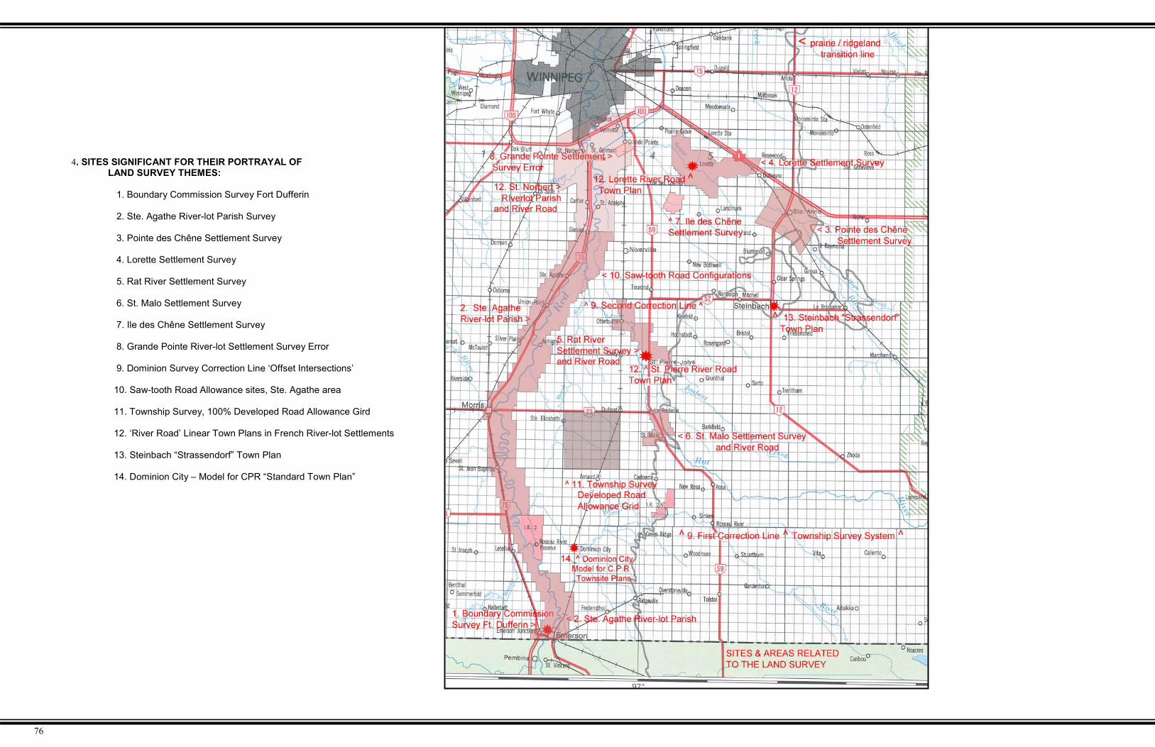
4. SITES SIGNIFICANT FOR THEIR PORTRAYAL OF LAND SURVEY THEMES:
1. Boundary Commission Survey Fort Dufferin
2. Ste. Agathe River-lot Parish Survey
3. Pointe des Chêne Settlement Survey
4. Lorette Settlement Survey
5. Rat River Settlement Survey
6. St. Malo Settlement Survey
7. Ile des Chêne Settlement Survey
8. Grande Pointe River-lot Settlement Survey Error
9. Dominion Survey Correction Line ‘Offset Intersections’
10. Saw-tooth Road Allowance sites, Ste. Agathe area
11. Township Survey, 100% Developed Road Allowance Gird
12. ‘River Road’ Linear Town Plans in French River-lot Settlements
13. Steinbach “Strassendorf” Town Plan
14. Dominion City – Model for CPR “Standard Town Plan”

77
5. SITES SIGNIFICANT FOR THEIR PORTRAYAL OF AGRICULTURAL SETTLEMENT THEMES:
Métis Settlement Areas Mé1. Maison Möise Goulet, St. Pierre-Jolys Mé2. Maison de la Montagne, St. Malo
Anglo Settlement AreasAn1. Town of Emerson sites
- Emerson Town Hall and Court House provincial heritage site- Former Masonic Lodge municipal heritage site- Former Creighton Terrace municipal heritage site- Former Presbyterian Church Manse municipal heritage site- Former Fairbanks Residence- Town Plan and Street Names
An2. Dominion City- Town Plan and Street Names
- Former Episcopal Methodist ChurchAn3. Clear Springs
French Riverlot SettlementsFr1. Village of Ste. Anne
- Ste. Anne des Chêne Roman Catholic Church- Main Street Boulevard, Street Names, Linear Development
Fr2. Lorette- Lorette Roman Catholic Church- Main Street Boulevard, Street Names, Linear Development
Fr3. Ile des Chêne- Ile des Chêne Roman Catholic Church- Main Street Boulevard, Street Names, Linear Development
Fr4. St. Adolphe- Ile des Chêne Roman Catholic Church- Main Street Boulevard, Street Names, Linear Development- Magazin géneral
Fr5. St. Pierre-Jolys- Former St. Pierre-Jolys Convent provincial heritage site- Main Street Boulevard, Street Names, River Road
DevelopmentFr6. St. Malo
- St. Malo Roman Catholic Church- Main Street Boulevard, Street Names- St. Malo Grotto
Fr7. La Broquerie- St-Joachim Roman Catholic Church
Mennonite Settlement AreasMn1. City of Steinbach
- Street pattern, orientation, and names- Mennonite Village Museum
Mn2. Mennonite Landing Site and Cairn, Rat River MouthMn3. Bergthal Cemetery CairnMn4. Site or former Immigration Barracks, and cemeteryMn5. Original Mennonite Village Sites, unmarked
Ukrainian Settlement Areas Uk1. St. Michael’s Ukrainian Orthodox Church National Historic Site Uk2. Gardenton Heritage Park and Museum Uk3. Overstoneville Ukrainian Cemetery municipal heritages site Uk4. Inventory of 22 Eastern European churches, RM of Stuartburn
German-Lutheran SettlementGr1. Fredensthal Church, Cemetery and Cairn

78
6. SITES SIGNIFICANT FOR THEIR PORTRAYAL OF INFRASTRUCTURE DEVELOPMENT THEMES
Settlement TrailsT1. Dawson Trail remnants
T2. Dawson Trail cairn in Ste. Anne
T3. Mennonite East Reserve Trail remnants
T4. Ste. Anne Trail remnants
T5. Ste. Agathe Parish Trail / St. Mary’s Road
RailwaysR1. C.P.R. Pembina Branch Line, first railway on the prairies
R2. Half-mile Road Adjustments along Pembina Branch Line
Bridge and Former Ferry sites B1. Former Letellier ferry site
B2. Former St Jean Batiste ferry site
B3. Former Aubigny ferry site
B4. Former Union Point ferry site
B5. Former Ste. Agathe ferry site
B6. Former St. Adolph ferry site and vessel
B7. Former St. Norbert ferry site
B8. Gardenton Howe timber truss bridge, municipal heritage site
B9. Dominion City timber truss bridge, municipal heritage site
B10. Ste. Anne Concrete Arch bridge, municipal heritage site
B11. Senkiw School Suspension Bridge, municipal heritage site
B12. Jordan River Concrete Box Bridge, municipal heritage site
B13. North Jordan River Concrete Box Bridge municipal heritage site
Land Drainage & Groundwater
D1. Manning Canal
D2. Dominion City Drains, earliest drainage works in Manitoba
D3. Springbank Well, Ridgeville area

79
7. SITES SIGNIFICANT FOR THEIR PORTRAYAL OFAGRICULTURAL THEMES
Mixed Farming- no identified mixed-use barn sites
Cereal CropsC1. Niverville, site of first commercial grain elevatorC2. Ridgeville standard grain elevator, abandonedC3. Dufresne grain elevator, eastern-most elevator
Bonanza FarmsB1. Lyman Bonanza farm, Arnaud areaB2. Other Bonanza farm locations unidentified.
Dairy ProductionD1. Holstein Cow town mascot statueD2. Cheese Plant, New BothwellD3. Cheese Plant, GrunthalD4. Wooden silo, St. Pierre-JolysD5. Sites of surviving early dairy barns.
Sugar Beets- no identified sites
Potatoes- no identified sites
Poultry- no surviving early poultry barns identified
Hogs- Hog barn concentration zone

80
The principal aim of this pilot study was to provide a regional perspective on rural heritage resourceissues for a selected study region in Manitoba, in contrast to the more common ‘site-specific’ focus on suchissues. As noted in the Introduction, the focus of much of the activity within the Historic Resources Branch sincethe proclamation of The Heritage Resources Act, (1986) has largely been building or site-oriented, with coreactivities involving developing museums, restoring significant early structures, and erecting commemorativeplaques. The activities of most private, community, and family-based initiatives in Manitoba have similarly beensite-oriented. The Manitoba Heritage Council was concerned that, with such emphasis on individual ‘site-specific’ heritage resources, other, perhaps equally significant and valuable types of heritage resources, werenot receiving proper attention, and as a result are being destroyed, remain as unprotected heritage gems, oreven undeveloped economic and recreational opportunities.
As well, can and should rural areas and communities be viewed from the broader ‘area’ perspectivewhich many cities have adopted (often with great success); Winnipeg’s Exchange District being one example.Are there other provincial statutes and government departments, which can or should play a greater role inmanaging these potential district and region-based heritage resources? And finally, how can the public at largebecome more involved in the preservation and development of Manitoba’s rural cultural landscapes? To beginto address these concerns and related issues, this pilot project was initiated as an investigation into the natureof regional heritage resources in Manitoba. To guide the research and final project report, three primaryobjectives were formulated. These are restated below followed by observations as to how well these objectiveswere attained.
OBJECTIVE #1:“To document the nature and evolution of the cultural heritage landscape for a selected region of Manitoba, withparticular emphasis on the relationships between the physical natural landscape and the effect of humanactivities and settlement on that landscape.”
The project report does succeed in providing a fairly comprehensive overview of the development of thenatural landscape of the study area and the subsequent human occupation and development of thatlandscape. The inter-relationships between certain aspects of the physical and human environment alsoare identified and documented, such as the correlation between the early transportation arteries and thenatural environment (i.e.: early trails following the river courses and the ‘ridgeline’ along the easternedge of the Red River Valley). Similarly, the correlation between settlement patterns and land use andsurface geography also is clearly shown. By these and other observations, the report does succeed inshowing the initial strong relationship between the physical landscape and the human landscape. Thereport shows, as well, how this relationship has decreased in recent decades with modern technologyincreasingly overcoming the effects and constraints of the natural environment, (i.e.: the network ofdrainage canals on the Red River Valley ‘flats’ permitting intensive agricultural production, or theclearing of the wooded eastern uplands with mechanized removal of the boulders and stones from thesurface, thereby permitting forage crops to be grown on what had long been considered largelyunusable land.
The report also succeeds in illustrating how agricultural development has radically altered the naturalvegetation zones in the study region, as a result of clearing the original ‘river-bottom’ tree-belts,particularly along the Red River, the clearing of the upland woodlands, and with the planting of field andfarmyard shelter-belts in the open prairie areas. Clearly, over time, the human landscape has come todominate the natural landscape in the region, to such an extent that mere vestiges of the former naturalenvironment remains. Such vestiges should be viewed as important natural heritage sites and areas.Discussions such as the effect of human occupation on the natural environment succeeds indocumenting the nature and evolution of the physical landscape of the study area, at least from a broadregional perspective.
OBJECTIVE #2:“To document the cultural heritage landscape, in such as manner that might help to stimulate interest and publicawareness as to the importance of cultural heritage landscapes in Manitoba, with the results of the researchbeing readily adaptable to various types of media, such as pamphlets and publications, internet sites and CD-ROM’s, and portable exhibits.”
This objective was largely attained by the highly illustrative and ‘modular’ format used to document andpresent the results of the project research. The entire report, including all text, maps and images, wasprepared using common PC computer equipment and software, resulting in a highly adaptive, fullydigital package which can easily be stored or viewed using standard PC equipment in the home, office,or classroom. Similarly, the highly illustrative nature of the report lends itself to use by a wide range ofaudience types and age groups, from school-age children to government employees. The ‘summaryoverviews’ or ‘capsulated histories’, prepared for each of the many historical themes used in the report,are intended to provide the reader with an understanding of the important aspects of each theme, as itrelates to the study region, without being burdened by long passages and minute details. Theseoverviews also are largely self-contained and easily converted for use as one-page, double-sidedhandouts for tourist, school or other purposes. Also, the liberal use of archival images help to provide ahighly visible portrayal of the region and the lifestyles of its residents, and help to reduce the amount oftextual material required. Images are more easily retained in memory than textual passages, therebyincreasing information retention in the reader. The intensive use of cartographic materials in particularsucceeds in creating an unusual and interesting final product. The manuscript reviewers invariablyfound themselves closely inspecting many of the maps used in the report, discovering and notingvarious items of interest that were ancillary or unrelated to the main discussion themes, and, as a result,generating additional interest in the subject matter and the region. Finally, the ‘modular’ format used inorganizing and presenting the information succeeds in allowing for rapid and easy navigation andinformation retrieval, particularly in digital-based presentations, such as PowerPoint presentations, CD-ROM, or Internet site use. This modular format also will permit additions to be made easily by simplyinserting sections in the appropriate location, headed with a next consecutive number in theorganizational system utilized. As a result of the modular and highly illustrative format, the reportsuccessfully meets the project’s public-awareness and multi-media objectives.
OBJECTIVE #3:To involve the collaboration of various government departments during the research stage of the project, aswell as information sharing at the conclusion of the project, in order to help integrate cultural heritagelandscape preservation issues into active policy and daily activities within these departments, particularlythose involving planning and tourism. The use of digital technology, particularly GIS plotting of significant sitesand elements, would help to facilitate the integration of results and concerns with these agencies.
Several government departments were consulted during the research stage to ascertain the types ofmaterials that might be useful to the project. All departments readily agreed to provide access toinformation in their files. These included Agriculture, Highways & Government Services, Maps &Surveys, and the Provincial Archives. The main difficulty in working with these agencies was notknowing in advance what materials each possessed. As a result, initial consultations usually consistedof a “show me what you have, and I’ll decide if I can use it” situation. This tended to be a timeconsuming process. Also, determining the best way of copying the materials, particularly the maps,involved trial-and-error attempts until a suitable process was developed. This involved digitally scanningthose maps that were in good condition and/or of small to moderate size. Larger, and older, fragilemaps had to be photographed in sections and the negatives then scanned and, on occasion, theimages digitally ‘stitched together’ to obtain copies of sufficient resolution and detail to be useful. TheProvincial Archives of Manitoba (PAM) was the best source of early maps, and despite the fragile natureof many of them, PAM staff was cooperative and enthusiastic about the project. Without theirassistance, only a fraction of the maps used in the final report would have been available for use. Withthese consultations and processes now in place, subsequent studies, if undertaken, would avoid theseinitial difficulties and bottlenecks. Also, because of the brief nature of the final overview summaries, staffin these branches were interested and willing to review the appropriate sections of the report to checkfor accuracy, completeness, etc. Overall, collaboration and interest on the part of other governmentdepartments was excellent, and staff in these departments expressed a high degree of enthusiasm inregards to receiving copies of the final report, or PowerPoint presentations, in order to better ascertainwhere and how their departments could play a role in helping to retain, preserve, and possibly developsome of the identified sites and resources of the Crow Wing Study Region.
2.0 Conclusions

81
Final Pilot Project Observations
Initially, it had been intended that this report would consist largely of ‘cut andpaste’ quoted passages from existing published sources of information in order to reducethe amount of research required, and to reduce the overall project time frame.Unfortunately, it was found that appropriate ‘summary discussions,’ did not exist for amajority of themes relating to the study region. Secondary – and occasionally – primarysource material had to be reviewed, and the summary discussions specially prepared forthis report.
Another item related to source materials concerned the difficulty in locatinghistorical information relating to the history of the region’s Francophone communities in theEnglish language. Most of the communities possessed the now-familiar ‘local history’publications produced in recognition of either the province’s or the community’s centennialanniversary. These publications were written invariably in the French language.Resources did not permit translation of these volumes, and, compounding the problem,most such publications are comprised of individual family history write-ups, with fewdiscussions involving district or regional themes and perspectives. Site or family specificdiscussions dominate such volumes. This lack of readily available information furthercomplicated the research phase of the project. It is hoped that, with this report completed,some of these informational gaps have been filled.
Another issue, which resulted in some difficulty, and increased the project timeline,involved the software program used to layout the manuscript. It was intended that the finalreport would be ‘user-friendly’ and viewable on any standard home or office computer. Forthis reason, Microsoft Word, one of the most common word-processing programsavailable, was used to prepare the final report. However, to be legible, most of the mapsused in the report had to be scanned at a fairly high resolution. The resultant large filesizes for each map, and the liberal use of maps in the report, created havoc during thereport layout stage. Layout programs which do not import the full-file image, such as QuarkExpress, which uses a temporary low-resolution copy of the image until the document is‘collected’ for printing, would have been much more appropriate for a report such as this.As well, without the benefit of a proper software program, the report layout was undertakenfree-hand, and as a result items such as image, text box, and title alignments, etc. are notentirely consistent.
Heritage Landscapes and Resource Management
Traditional heritage resource issues are managed under a legislative and policy framework, which isimplemented in Manitoba via a number of provincial level coordinating bodies for the review andmonitoring of projects, activities and alterations to existing developments. Heritage Landscapepreservation and management initiatives could and should make use of a variety of tools currentlyavailable in Manitoba’s legislative and policy framework. The main components of this integrated approachare:
The Heritage Resources Act (1986)� Provincial and municipal heritage site designation;� Heritage resource impact assessment;� Heritage covenants; and� Municipal heritage advisory committees.
The Environment Act (1988)� Environmental licensing;� Departmental referral process with screening by HRB to identify potential adverse effects to heritage
resources;� Environmental Impact Assessment (EIA) of major projects, such as hydro-electric developments,
forestry operations and roadways, which include heritage resources, traditional land uses.
The Sustainable Development Act (1998)� Framework for implementation of sustainable development in public sector and promotion of its use in
private industry and society in general;� Principles and Guidelines for Sustainable Development;� “Full-cost accounting” including “… social and heritage costs and benefits of specific decisions or
actions, including externalized costs…”;� Provincial Code of Practice, applicable to Crown corporations; and� Sustainable development indicators.
Sustainable Development Strategies with policy statements concerning the identification, protection andinterpretation of heritage resources include:� Natural Lands and Special Places Strategy;� Minerals Strategy;� Water Strategy;� Forestry Strategy;� Capitol Region Strategy.
Consultation on Sustainable Development Implementation (COSDI)� Requirement for municipal review and adoption of development plans that reflect sustainable
development;� Inclusion of all sustainability factors, such as environment, economic, social, cultural and human
health effects, in the concept of effects assessment;� Integrated large area planning to identify main issues, including heritage, for the long term (more than
5 years), to set targets and to ensure those priorities are implemented;� Effects assessment, including assessment and review of cultural and heritage values;� Land and resource use decisions, including cultural/heritage values;� Commitment of Manitoba to “recognize and respect the distinctive cultures, histories and traditions of
the First Nations peoples of Manitoba”;� Recognition that “The traditional knowledge of First Nations is integral to land and resource use
planning, significant resource allocation, environmental licensing and regulatory mechanisms such aseffects assessment”;
� Commitment of Manitoba “That sustainable development processes recognize the importance of theculture, knowledge, traditions, cultural and spiritual values of Aboriginal peoples.”; and
� Commitment of Manitoba “That local knowledge (Traditional Environmental Knowledge or TEK),special naturalized, and community-based knowledge be recognized and considered in sustainabledevelopment processes.”

82
The Parklands Act (1993)� Conservation of representative examples of diverse natural and cultural heritage;� Preservation of unique and representative natural, cultural and heritage resources;� Inclusion of a heritage park classification in Manitoba’s Parks system plan, e.g., St. Norbert
Heritage Park;� Inclusion of heritage zones in Park land use categories, e.g., Tie Creek Basin;� Inclusion of heritage zones and land use categories to address resource protection, use,
development in Park management plans; and� Ministerial regulations respecting the protection of cultural, historical and archaeological
resources.
The Planning Act (1999)� Provision for creation of Municipal Heritage Conservation Zones*;� Definition of the parameters of control and statement of development standards;� Provincial Land Use Policies as a Regulation under The Act;� Establishment of the planning framework for local government.
*In Manitoba, the powers to create heritage conservation districts (zones) rest at the municipal level.These powers are expressed as zoning initiatives contained in The Planning Act and The City ofWinnipeg Act. In 1998, Historic Resources Branch worked with the Department of Rural Developmentto introduce the municipal powers for creating heritage conservation zones into The Planning Act.
Provincial Land Use Policies (Manitoba Regulation 184/94)� The Provincial Land Use Policies guide Provincial and municipal review of land use plans and the
development of individual projects that could have environmental impacts;
� Provincial use of the policies as a benchmark in the review of subdivisions or other development inareas where a development plan has not been adopted; local plans replace these policies, but areevaluated in relation to the policies;
� Application of the policies to all land in Manitoba excepting the City of Winnipeg;
� Policy #6 - Natural Features and Heritage Resources states that “Significant natural features andheritage resources, and areas required to sustain threatened or endangered plants and animals,shall be protected”;
� In addition, reference in Policies #1, 4 and 5 and the Subdivision Policies to the protection ofheritage resources (There are 9 Policies, plus the Subdivision Policies.)
Local Land Use Plans (Development Plans and Zoning)� Local land use plans take direction from Provincial Land Use Policies and supercede them when
the plan is implemented;� HRB provision of a “Basic Policy Statement Relative to Heritage Resources"” to planning
authorities when plans are being prepared or reviewed; staff review of draft plans before approval.� Initiation or implementation of development plans by all but 12 municipalities in Manitoba.
OPPORTUNITIES AND CHALLENGES
� Environmentalists have garnered widespread public support and action. Heritage supporters havenot attained the same level of public acceptance and action.
� Legislative and policy frameworks exist and public processes are available for individuals,organizations and governments to identify, preserve and protect heritage resources. However,except for federal, provincial and some municipal governments which use the system, mostindividuals or organizations espousing heritage interests do not participate in the public processesor use the opportunities that are available, e.g., hearings on forest management plans, parkmanagement plans, major projects, the Environment Act project registry.
� The focus of concern should be expanded from protecting individual sites to the development ofheritage plans, including the “broader“ cultural landscape, e.g. Winnipeg’s Exchange District, asopposed to individual buildings within the city’s core area.
� The concept of cultural landscape is not new, having been successfully implemented under theUNESCO World Heritage Convention and by Parks Canada and the United States Parks Service,although varying definitions of cultural landscape are employed.

83
3.0 BIBLIOGRAPHY
PUBLICATIONS:Blom, Rose R. Taché Rural Municipality: 1880-1980. Rural Municipality of Taché, 1980.
Combet, Denis. In Search of The Western Sea: Selected Journals of La Verendrye. Great PlainsPublications, 2001.
Densmore, Frances. Chippewa Customs. Minnesota Historical Society, 1979.
Ellis, J.H. The Ministry of Agriculture in Manitoba, 1870-1970. Manitoba Department of Agriculture, 1970
Epp, Frank H. Mennonites in Canada, 1786-1920: The History of a Separate People. MacMillan Companyof Canada, 1974.
Gilchrist, Emma. Pages from Ridgeville's Story. Ridgeville Women's Institute, 1967.
Gillies, Ian. Prystupa, Steven. and Wynobel, Cornel. Manitoba and Its Great Resources - An IllustratedHistory of Resource Development in Manitoba. Natural Resource Institute, University of Manitoba, 1977.
Gilman, Rhoda. Gilman, Carolyn. and Stultz, Deborah. The Red River Trails: Oxcart Routes Between St.Paul and the Selkirk Settlement 1820-1870. Minnesota Historical Society, 1979.
McClelland, James. and Lewis, Dan. Editors. Emerson 1875-1975: A Centennial History. EmersonChamber of Commerce, 1975.
McClelland, Elmer. A View Form Inside the Portcullis - A History of Emerson Customs and General Area,1992.
Montcalm History Book Committee. Reapers of the Valley, 1882-1982 A History of the Municipality ofMontcalm, 1982.
Morton, W.L.. Manitoba: A History. University of Toronto Press, 1957.
Nichols, Christine M. Arnaud Through the Years. Arnaud Historical Committee, 1974.
Montcalm History Group. Reapers of the Valley 1882-1982: A History of the R.M. of Montcalm, 1982.
Teller, James T. The Natural Heritage of Manitoba - Legacy of the Ice Age. Manitoba Museum of Manand Nature, and Manitoba Nature Magazine, 1984.
Penner, Lydia. Hanover: One Hundred Years. Rural Municipality of Hanover, 1982.
Plett, Delbert F. Celebrating Our Heritage: 125 East Reserve, Hanover, Steinbach, 1874-1999. HanoverSteinbach Historical Society, 1999.
Tyman, John L. By Section Township and Range: Studies in Prairie Settlement. Assiniboine HistoricalSociety, 1972.
Waddell, James McKercher. Dominion City Facts, Fiction and Hyperbole, 1970.
Willis, Jocelyn. “Divided Loyalties – Private Ambition, Nation-building, and the Railroad Racket Along theNorthwestern Borderlands, 1877-1883”, in Journal of the West, Vol.39, No.2. Manhattan, Kansas, Spring2000.
Warkentin, John. and Ruggles, Richard. Historical Atlas of Manitoba. Historical and Scientific Society ofManitoba, 1970.
Welsted, John. Everitt, John. and Stadel, Christoph. The Geography of Manitoba - Its Land And ItsPeople, The University of Manitoba Press, 1996.
REPORTS:Adams, Thomas. Rural Planning and Development: A Study of Rural Conditions and Problems inCanada. Commission of Conservation. Ottawa, August, 1917.
Champagne, Lynn. "The Last Spike of the C.P.R.- Pembina Branch". Historical Resources Branch.unpublished report, 1978.
Economic Development Council for Manitoba Bilingual Municipalities (CDEM). ExperienceManitoba's joie de Vivre, undated pamphlet.
Krenz, Gene. and Leitch, Jay. A River Runs North - Managing an International River. The RedRiver Water Resources Council, 1993.
Ledohowski, Edward M. “The Neepawa and Area Planning District Report”. Historic ResourcesBranch unpublished report, 1981.
Livermore, Carol. Lower Fort Garry, The Fur Trade and The Settlement at Red River. ManuscriptReport Number 202. National Historic Parks and Sites Branch, Parks Canada, Department ofIndian and Northern Affairs. 1976
MAP SOURCES:- The Manitoba Provincial Archives;- Manitoba Maps & Surveys Branch;- Manitoba Highways Branch;- The Historical Atlas of Manitoba, by the Manitoba Historical Society;- Historic Resources Branch files
MISCELANEOUS:
Lehr, John and Ledohowski, Edward. “Vestiges of the Old Country - Vernacular Landmarks andSettlement Patterns in Southeastern Manitoba”. Unpublished tour guide for "A.P.T.’96 TourNo.17", September 20, 1996.
Manitoba Culture, Heritage and Citizenship. Historic Resources Branch. Assiniboin (Nakota) FirstNation, pamphlet, 1997