633 / ~ ·~ vjpor ~tf?o( contractor report · in the field work. 4 ... reports on various aspects...
TRANSCRIPT

VJPOr ~tf?O(
CONTRACTOR REPORT
SAN084- 7 178 Unlimited Release UC,-70
633 / ~ ·~
·d~ c~'J
;t I ; .. ~~
:- ,.,.~ -f~· .
~ .: ,.
• I
.!- b . '
Assessment of Near-Surface Dissolution · At and Near the Waste Isolation Pilot Plant (WIPP), Southeastern New Mexico
George 0. Bachman, Consultant Star Route, Box 1028 Corrales, NM 87048
Prepared by Sandia National Laboratories Albuquerque. New Mexico 87185
and L•vermore, Calilornia 94550 lor the United Stales Department of Energy under Contract DE·AC04-76DP00789
Printed July 1985

-~ -
Issued by Sandia National Laboratories, operawd for the Uniwd Slaws Department of Energy by Sandia Corporation. NOTICE: This report was prepared as an account of work sponsored by an agency of the Uniwd ~taws Government. Neither the Uniwd States Government nor any agency thereof, nor any of their employees, nor any of their contractors, subconttactors, or their employees, makes any warranty, ex· press or implied, or assumes any legal liability or responsibility for the ·accuracy, completeness, or usefulness of any information, apparatus, product, or process disclosed, or represents that its use would not infringe privately owned rights. Reference herein to any specific commercial product,
.process, or service by trade name, trademark, manufacturer, or otherwise, • does not neces51¢1y_ Colllltitute or imply its endorsement, recommendation, or favoring by the United States Government, any agency thereof or any of
: their contractors or subcontractors. The views and opinions expressed herein do not necessarily state or reflect those of the United States Government, any agency thereof or any of their contractors or subcontractors:
Printed in the Unitel.t States of America Available from National Technical information Service U.S. Department of Commerce 5285 Port Royal Road Springfield, VA 2216'1
NTIS price codes Prinwd copy: A02 Microfiche copy: AOI'
Information Only ----

..
SAND84-7178 Unlimited Release Printed July 1985
Distribution Category UC -70
Assessment of Near-Surface Dissolution · At and Near the Waste Isolation Pilot
Plant (WIPP), Southeastern New Mexico
George 0. Bachman,. Consultant Star Route, Box 1028 Corrales, NM 87048
Abstract The area at and near the WIPP site was examined for evidence of karst development on the geomorphic surface encompassing the site. Certain surficial depressions of initial concern were identified as blowouts in sand dune fields (shallow features unrelated to karstification). An ancient stream system active more than 500,000 yr ago contained more water than any system since. During that time (Gatufia, Middle Pleistocene), many karst features such as Clayton Basin and Nash Draw began to form in the region. Halite was probably dissolved from parts of the Rustler Formation at that time. Dissolution of halite and gypsum from intervals encountered in Borehole WIPP-33 west of the WIPP site occurred during later Pleistocene time (i.e. , <450,000 yr ago). However, there is no evidence of active near-surface dissolution within a belt to the east of WIPP-33 in the vicinity of the WIPP shaft.
Information Only 3
....
Acknowledgments Funding for this study was provided by Sandia
National Laboratories {Agreement 48-9558). SueEllen Shaffer, Sandia National Laboratories, assisted in the field work.
4 Information Only

Contents Foreword ....................................................................................................................................................................... 7 Introduction ................................................................................................................................................................. 9 Physiography ................................................................................................................................... ............................. 9 Geology.......................................................................................................................................................................... 10 Stratigraphy ................................................................................................................................................................. 11
Tertiary Deposits..................................................................................................................................................... 14 Introduction.......................................................................................................................................................... 14 Ogallala Formation .............................................................................................................................................. 14
Pleistocene Deposits ................................................................................................................................................ 14 Gatuna Formation ............................................................................................................................................... 14 Mescalero Caliche . ......................... ........................ ........... ....... ....... .......... .... ....... ... .... ....... ... ..... ....... ......... .... ... ... 19 Berino Soil ......... ..... .... ....... ....... ....... ... ........... .......... .... ....... .............. ....... ....... ......... .. ... ....... ... ........... ................. .. 20 Spring Deposits .................................................................................................................................................... 20 Playa Deposits ...................................................................................................................................................... 21 Alluvium .... :........................................................................................................................................................... 21 Windblown Sand .................................................................................................................................................. 21
Karst and Near-Surface Dissolution ......................................................................................................................... 23 Discussion and Conclusions ....................................................................................................................................... 26 References ...... ......... .... .............. ....................... ....... ....... .......................... ... ...... ..... ... . ..... ...................... ....... ........... ...... 28
Figures 1 Index map showing major features discussed in t his report ........................................................................ 10 2 Isopach map of Rustler Formation .................................................................................................................. 13 3 Cross-bedded pebble conglomerate in channel deposit at base of Gatufia Formation ............................ 15 4 Isopach map of Gatuna Formation .................................................................................................................. 16 5 Isopach map of Triassic rocks .. .. .................................. ...... .................. ........ ...... .............. ...................... ...... .... 17 6 Isopach map of Dewey Lake Red Beds . ......................... ..................................... ............... ........... ... . ... ....... .... 18 7 Mescalero caliche engulfing Triassic rocks ...... ................. .... .... ... ....... ....... ........... ... .......... ............................. 20 8 Coppice dune on skyline, on rim of blowout.................................................................................................. 22 9 Blowout in dune sand........................................................................................................................................ 22
10 Mud-cracked pan in bottom of blowout ......................................................................................................... 23 11 Map showing distribution of Gatuna Formation (stippled) and probable course of streams during
Gatufia time (arrows) ......................................................................................................................................... 25
Information Only s - 6

Foreword This .report is a partial accounting of work by
George 0. Bachman on behalf of Sandia National Laboratories as part of continued characterization of surface geology at the Waste Isolation Pilot Plant (WIPP) site. Mr. Bachman is writing a series of reports on various aspects of the surface and subsurface geology of the Delaware Basin of southeastern New Mexico. All these reports deal with dynamic geological processes as they affect the survivability of the evaporites in the Delaware Basin and the longterm integrity of the natural systems that must continue to isolate radioactive wastes emplaced in evaporites at the WIPP.
This report deals with the occurrence of the Quaternary Gatufta Formation at and near the WIPP site. In addition, the Gatufia Formation is placed into a context with respect to a major dissolution-subsidence feature (Nash Draw) and several other smaller collapse sinks. Logic leading to inferences about the origins of these various collapse features is not repeated here, as such description appears in detail in other reports by Mr. Bachman. Consequently, several of the statements made herein are not accompanied by the complete set of substantiating descriptions and discussions.
Several geomorphic features around the site (specifically, blowouts among sand dunes, sinkholes in gypsic terrain, and closed depressions at Boreholes WIPP-14 and WIPP-33) have been cited by Barrows and others (1983) as evidence of a pervasive geologic process of shallow- and deep-seated karst formation. This proposition arose from one possible interpretation of Bouguer gravity anomalies near the site. Whereas this report does not specifically attempt to reinterpret the gravity anomalies, it does make conclusions about the relationships between the paleoclimate, paleohydrology, distribution, and thickness of stream deposits of the Gatufia Formation, and about the near-surface paleodissolution in the Rustler
Formation. Channels in the Gatufta Formation may be important in interpreting the Bouguer gravity anomalies; the geological relationships described herein may suggest alternative explanations for the Bouguer gravity anomalies other than deep-seated pervasive karst. Whereas this report does not specifically attempt to evaluate all the various implications of karstic terrain with respect to groundwater movement, it provides some background for other reports that will directly discuss this issue, many of which will use laboratory and numerical methods as well as field mapping. In addition it concludes that "true karst features should not be predicted on the Livingston Ridge surface east of the indicated dissolution front in the Rustler," thus providing geographic bounds for the area of karstic processes in evaporites. This geographic constraint will be discussed further, together with the processes themselves, in a subsequent report.
This report is important to evaluating the longterm suitability of the WIPP in that it emphasizes the significance of conditions in the paleoclimate, paleohydrology, and paleodissolution that are quite different from presently observable conditions. These geological extremes over several thousand years can complicate interpretations of data representative of the present; one such set of interpretations has been specifically requested by the New Mexico Environmental Evaluation Group: the "water-balance study" (cf USDOE, 1983).
Finally, this report directly addresses another concern of the Environmental Evaluation Group: "drill a shallow auger-hole in the depression in the SW corner [of Sec. 29, T22S, R31E] in Zone III to address the suspicion of this depression being a doline" (cf USDOE, 1983).
Steven J. Lambert Sandia National Laboratories
Information Only 7- 8

. .
Assessment of Near-Surface Dissolution At and Near ·the Waste Isolation Pilot
Plant {WIPP), Southeastern New Mexico
Introduction The Waste Isolation P ilot Plant (WIPP) is a
facility being developed by the US Department of Energy (DOE) for burying radioactive waste in underground beds of salt in Eddy County, NM. Although the proposed facility is more than 2000 ft (615 m) below the surface, there is continuing concern fur the stability of rock adjacent to the host beds.
Strata overlying the WIPP facility horizon include sandstone, clay, and evaporites such as gypsum, anhydrite, and salt. If these evaporites are being actively dissolved in the subsurface, collapse sinks and related karst features should become apparent at places on the surface. Although no karst features have been definitely recognized on the surface closer than -3 mi (4.8 km) from the WIPP shaft, subsurface dissolution has been interpreted as present at and near the site from a recent gr.avity survey (Barrows and others, 1983).
The present study applying standard geologic techniques was undertaken to determine if active subsurface dissolution of evaporite beds is a plausible process in the modern geologic setting at the WIPP site. This study included examining available borehole data and surface features in the WIPP area. Other data, such as existing geologic maps, were examined and interpreted. Data from all these sources were used to construct the isopach maps and diagrams accompanying this report. These observations pro: vided information for outlining the physiographic history of the modern terrain. Consideration of that history is essential to understanding the natural setting of the WIPP site.
Physiography The WIPP site, located -25 mi (40.2 km) east of
Carlsbad, Eddy County, NM (Figure 1), is situated on an unnamed physiographic surface that we call the Livingston Ridge surface for purposes of this discus-
sion. The surface is underlain by caliche and windblown sand. Mesquite, shinnery oak, creosote bush, and associated flora of the Chihuahuan Desert characterize this semiarid region. The major physiographic features that have been a part of the recent geologic history of the area include Nash Draw, the Livingston Ridge surface, and The Divide. The Pecos River, whose modern course lies -20 mi (32 km) west of the WIPP site, has been a major influence in the physiographic history of the region.
Nash Draw is the most distinctive topographic feature at or near the WIPP site. A northeasterly trending depression -19 mi (30.6 km) long, it ranges from -5 mi (8 km) wide in its central portion to -10 mi (16.1 km) wide in its northern portion. The greater width in the north results from erosional dissection that bifurcates the drainage system into a northwestern and a· northeastern lobe. Nash Draw is bounded on the west by Quahada Ridge and on the east by Livingston Ridge. Along its north rim the Maroon Cliffs form a .barrier between Nash Draw and Clayton Basin.
The Livingston Ridge surface stretches eastward from Nash Draw - 12 to 13 mi (19.3 to 20.9 km) to Antelope Ridge, which lies along the western edge of San Simon Swale (Figure 1). The surface is a rolling, featureless plain.
Windblown sand has accumulated over much of the Livingston Ridge surface and in parts of Nash Draw and San Simon Swale. Some active dunes are present in the Los Medaflos area on the southern part of the Livingston Ridge surface. Active dunes are also present locally at other places, but most of the windblown sand is in the form of stabilized coppice dunes-accumulations of sand around mesquite and other plants. The active dunes take the form of incipient crescent-shaped barchans or elongate transverse dunes. Closed depressions called "blowouts" are common features within both stabilized and active dune areas.
Information Only 9

R30E R31E 104°00'
canyon
T20S
32°30' + T21S
T22S
T23S
R30E
R32E 103"45'
103"45 ' R31E
0 2 4 6 MILES I lwww lweee I . F*F,....,_,..-1
R33E
R32E
0 2 4 6 8 10 KILOMETERS
Figure 1. Index map showing major features discussed in this report
Geology
R34E
Jt ·
$ T20S.
32"30'
T21S
T22S
T-235
R33E
The Divide is the proper name for a low hill rising above the Livingston Ridge surface and separating surface drainage towards Nash Draw on the west and San Simon Swale on the east. Much of the drainage around The Divide is now masked by windblown sand; visible drainage is intermittent and discontinuous. The entire area of the Livingston Ridge surface and The Divide has been a stable area of low relief for at least the past 500,000 yr (Bachman, 1980). Previously, westerly trending ridges and intervening swales ·with through-flowing streams radiated from the general area of The Divide. Gradients were low, with streams of low to moderate energy.
· The geology of the WIPP site has been discussed extensively in the literature (Jones, 1973 and 1978; Bachman, 1980 and 1984; Lambert, 1983; Mercer, 1983; Borns and others, 1983). Only factors pertinent to a discussion of late geologic history and to the problem of dissolution will be treated here.
10 Information Only

Stratigraphy . The stratigraphy of the WIPP site has been dis
cussed previously in detail (Jones, 1973 and 1978; Mercer, 1983; Lambert, 1983) and is presented only in outline here. Rocks in the stratigraphic column bearing on the present study are Permian, Triassic, Tertiary, and Quaternary in age. Permian rocks include four formations of the Ochoan series. In ascending order, these are the Castile, Salado, and Rustler Formations and the Dewey Lake Red Beds. They are overlain unconformably by clastic sediments of Triassic age. Surface and near-surface rocks include the Ogallala Formation and a variety of surficial deposits (Table 1).
Castile and Salado rocks are very soluble and are represented by dissolution breccia where they occur at the surface -25 mi (40 km) southwest of the WIPP site. At the WIPP site both these units are deeply buried and apparently have not been exposed to dissolution. Of the stratigraphic units close to the surface at and near the WIPP site, anhydrite, gypsum, and salt in the Rustler Formation in the subsurface are the most susceptible to dissolution resulting in karst features at the surface.
In addition to these evaporites, the Rustler includes the water-bearing Culebra and Magenta Dolomite . Members. The water in these members is usually confined to the individual members where these are within an impermeable sequence of anhydrite or gypsum. Where the Rustler is exposed in Nash Draw, the dolomite members are fractured and the gypsum beds are disrupted by many collapse sinks and caves as a result of local dissolution. At places in the subsurface underlying the Livingston Ridge surface, boreholes have encountered cavernous intervals and clayey residuum at horizons where salt and gypsum are present normally in more complete stratigraphic sections.
T he quality of the water in the dolomite members has been discussed in detail by Mercer (1983). Qualities vary widely over the region and are classified as saline to briny. "Dissolved solids in waters associated with the Culebra Dolomite Member range in concen-
tration from 3,200 milligrams per liter ... to 420,000 milligrams per liter" 'in test' holes at and near the WIPP site (Mercer, 1983, p 62). "Dissolved solids in water associated with the Magenta Dolomite Member ... range in concentration from 5,460 milligrams per liter ... to 270,000 milligrams per liter" (Mercer, 1983, p 68). Both waters are capable of dissolving more solids. Saturated brine occurs in a clayey brecciated unit at the basal contact of the Rustler with the Salado Formation in the subsurface in Nash Draw.
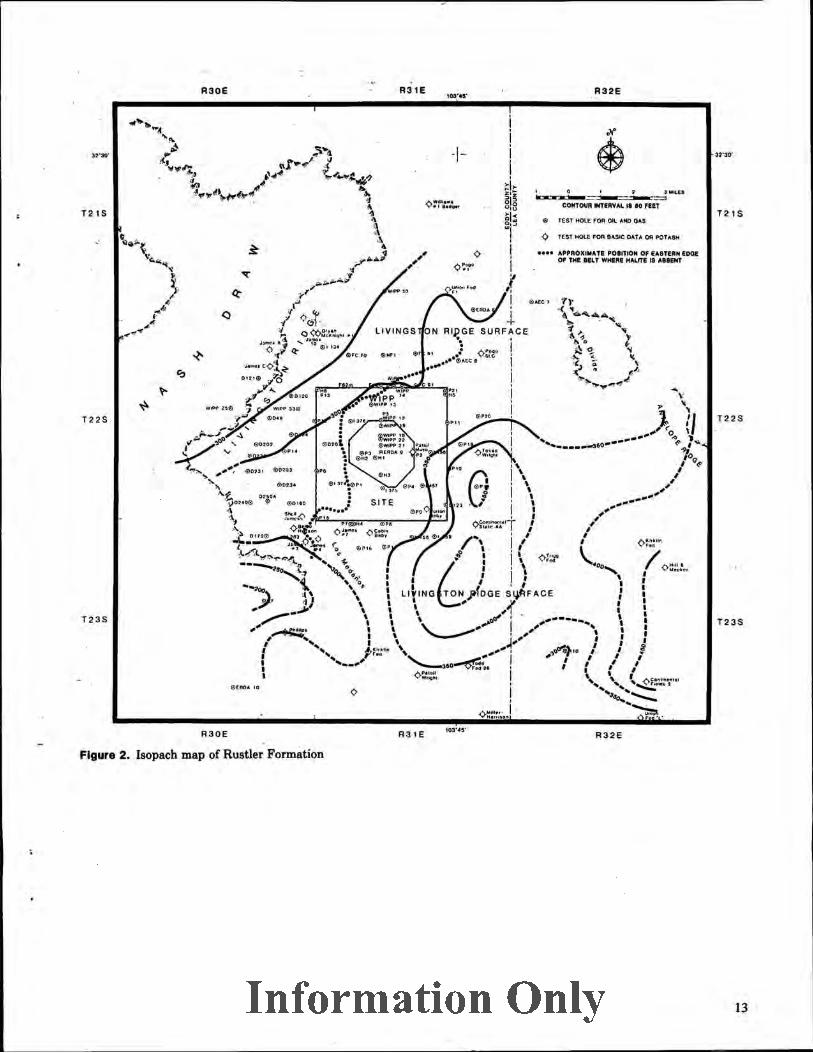
The Rustler Formation varies in thickness from 263 ft (80.2 m) in the subsurface in Nash Draw (Borehole WIPP-27) to 460ft (140.2 m) near the southeastern edge of the site (Borehole P-18). The thinning of the formation in Nash Draw is attributable to dissolution of evaporite beds in the formation. Thinning of the formation beneath the Livingston Ridge surface is attributed both to dissolution of salt within the formation and to variations of thickness during original deposition (Jones, 1973, p 23; Mercer, 1983, p 45). Figure 2 shows some of the variations.
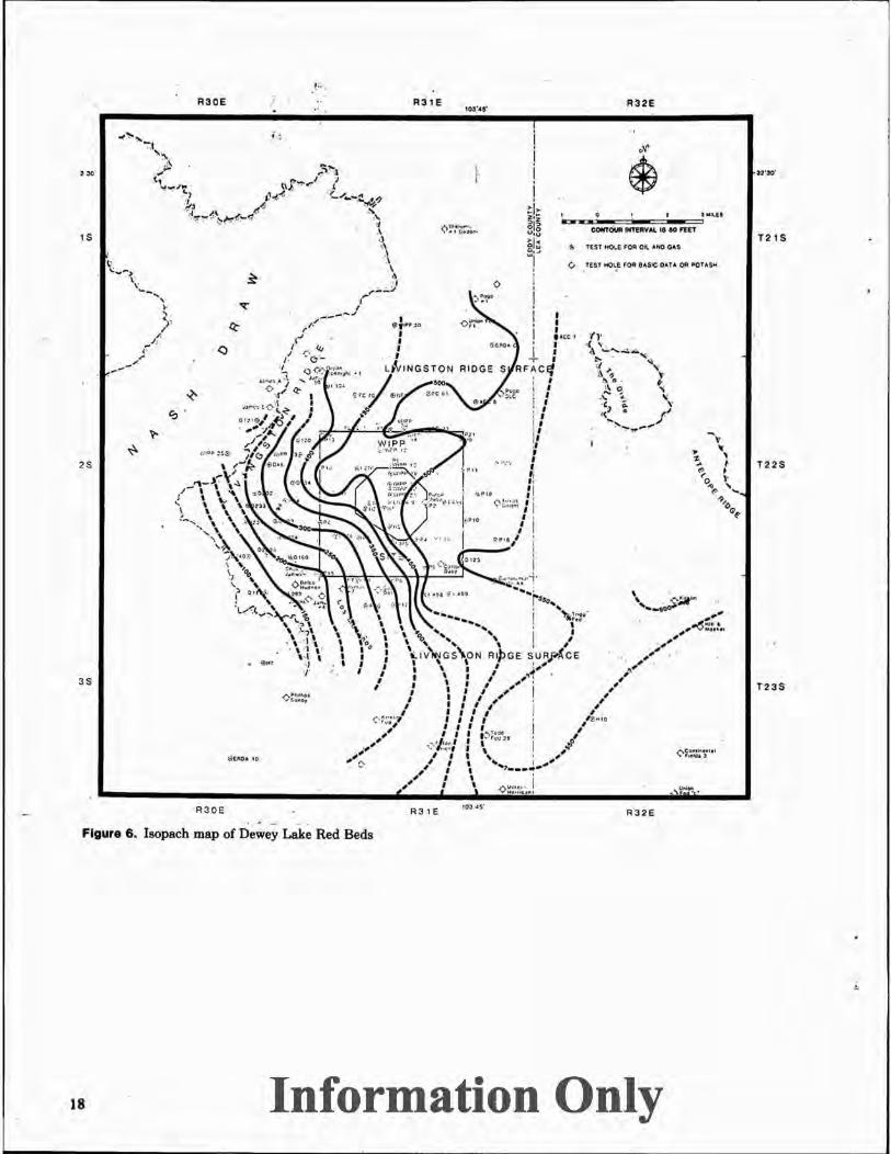
The regional dip of rocks at the WIPP site is easterly -75 to 100 ft/mi (14 to 18 m/km). Owing to this regional dip, rock units are more deeply buried from west to east. Thus the Rustler Formation is exposed at the surface in Nash Draw. At Livingston Ridge along the eastern edge of Nash Draw, the Rustler is buried beneath Dewey Lake Red Beds to a depth of 200 to 300 ft (61 to 91 m). At the WIPP site the Rustler is beneath 300 to 400 ft (91 to 122 m) of Dewey Lake Red Beds. At and near The Divide the Rustler is covered by >500ft (152m) of Dewey Lake Red Beds and 200 to 300 ft (61 to 91 m) of Triassic rocks.
Rocks of both the Dewey Lake Red Beds and Triassic are composed of insoluble clastic rocks. Karst features cannot be expected to develop in these units unless there has been extensive dissolution in underlying formations. Although veinlets and pods of selenite at many places in the Dewey Lake Red Beds indicate circulation of sulfate-bearing waters in this unit in the past, the Dewey Lake at present "has not normally been found to yield water to wells" (Mercer, 1983, p 70).
Information Only 11

Ta~le 1. Su.,mary of Stratlgra·phlc Units Discussed In Thla Report At and Near the WIPP Site
System Series
Quaternary Recent
Pleistocene
Formation
Windblown sand Alluvium P laya deposits
Spring deposits
Berino soil
Mescalero caliche Gatuiia Formation
Thickness (ft)
0 to 30 0 to 20 0 to 50
0 to 30
0 to 4
0 to 10 0 to 70+
Characteristics
Sand dunes Arroyo deposits Silt and clay in closed basins
Gypsite spring mounds and runoff deposits
Dark reddish, clayey, noncalcareous paleosol
White ledge-forming caliche Dark reddish-brown to
yellowish-brown gravel, sand, silt
------------------ ? ----- ? ---------------- ? ---- ? -------------------------------------------------------------------------------
Tertiary
Triassic
Permian
12
MiocenePliocene
Ochoan
Ogallala Formation
Dockum group, undivided
0 to 26+
0 to 300+
Dewey Lake Red Beds 150 to 550
Rustler Formation 300 to 450+
Salado Formation 1800 to 2000
.Castile Formation ±2000
Gray to yellowish-gray sand and gravel, capped by distinctive pisolitic caliche. Preserved at The Divide and Grama Ridge
Reddish-brown to gray, coarse sandstone and conglomerate
Reddish-brown fine-grained sandstone. Many greenish-gray reduction spots
Gypsum, anhydrite, salt, and dolomite. (Includes the Culebra Dolomite Member near the middle and the Magenta Dolomite Member in the upper part.)
Salt, potash minerals, and minor beds of gypsum and clay. Beds in this formation are being examined as potential host rocks for emplacing radioactive waste
Anhydrite and gypsum with interbeds of salt
Information Only
A3 0E
, .....
T2 1S
,·
T22S
T23S
R30E
A31E 1oa·••·
ON Rlp GE SURFACE .. ' : A- I • •• . • ''MC. i
..... . ••e~otC I ! I I ..,,.....uuo._,JIIIii;~~~~J.!.. ...... ., .. I
0
R31E •OJ····
0
A32E
A~,~Ol ... AH ~OIIT- CW UITl~MICW 1144! - T _,.,._ IIAUR II AIIIMT
R32E
Figure 2. Isopach map of Rustler Formation
Information Only
T21S
T22S
T23S
13

Tertiary Deposits
Introduction Although there are many gaps in the stratigraphic
record, rocks of Tertiary and Quaternary age preserve the latest geologic history of southeastern New Mexico. A particularly long gap occurs in the record through early Tertiary time, and the physiography of the region at that time can only be conjectured. The region was above sea level; presumably erosion was the dominant process.
Ogallala Formation The Ogallala Formation of Miocene and Pliocene
age underlying the High Plains from Nebraska southward to western Texas and eastern New Mexico reflects a period of uplift and erosion of the Rocky Mountains. This formation was deposited mostly as a complex sequence of alluvial fans on an irregular erosion surface by streams flowing toward the south and east from the young mountains. In southeastern New Mexico extensive deposits of windblown sand characterize the interstream deposits of the Ogallala. Although the Ogallala Formation is now a remnant of a major depositional cycle in the past , it represents the first stage in developing the modern landscape.
At the termination of Ogallala deposition the region was unusually stable. A thick pedogenic caliche that accumulated on the surface is preserved as the well-known caliche "caprock" of the High Plains. The caprock is a complex deposit formed during at least 3 million years of desiccati<?n, brecciation, and recementation.
The Ogallala Formation is as much as 400 ft (122m) thick at places in southeastern New Mexico. A thin remnant 26 ft (8 m) thick is preserved at The Divide -6 mi (9.6 km) east of the WIPP site. This remnant is significant to the interpretation of the physiographic history of the region. It may represent a western depositional wedge-edge of the Ogallala across a relatively high surface. Examination of the isopach maps accompanying this report suggests that the general area of The Divide was a positive topographic feature as long ago as Ogallala time.
Regional drainage during Ogallala time was towards the south and the southeast, but details of the drainage system at or near the WIPP site are not clear because extensive deposits of t he formation are not available for analysis. It is probable that an ancestral Pecos River flowed southward in New Mexico along a course within 3 to 10 mi (5 to 16 km) east of its present channel. Thick deposits of alluvial fill to the south in Texas may be, in part, the result of this drainage and
depositional episode. These alJuvial deposits are > 1500 ft (460 m) thick (Maley and Huffington, 1953). They were deposited in basins formed by subsidence, or collapse, as a result of dissolution of salt from formations in the subsurface. The older parts of these deposits are present only in the subsurface, and their presence is known only from exploratory boreholes for oil and gas. Evidence is not available to determine the age of these deposits.
Major changes in drainage occurred later in Pleistocene time when some secondary drainages flowing westward from the High Plains were developed. These drainage systems flowed into the ancestral Pecos River (Bachman, 1984).
Pleistocene Deposits
Gatuna Formation The Gatuna Formation is at least as old as Middle
Pleistocene and may contain some much older deposits. Characteristically it consists of reddish-brown, poorly consolidated sand, gravel, and silty clay. Deposits that are assigned to the Gatuna Formation are distributed along the east side of the Pecos River in Nash Draw, Clayton Basin, and east of Artesia and Hagerman, NM -30 to 50 mi (48 to 80 km) north of Carlsbad (Bachman, 1976). In Pierce Canyon -20 mi (32 km) southeast of Carlsbad it includes stream gravels that have collapsed into ancient sinks.
In the vicinity of the WIPP site, the Gatuna rests unconformably on the Dewey Lake Red Beds. It is ·overlain by the pedogenic Mescalero caliche, which accumulated on stable surfaces following Gatufia deposition. The presence of the Mescalero caliche overlying the formation separates the Gatuna from other deposits and aids in distinguishing the formation.
The age of the Gatuna Formation is based on the presence of a thin bed of volcanic ash within the formation on the east side of Nash Draw. The ash has been identified as a member of the Pearlette family of ash falls, the "Lava Creek B ash" (lzett and Wilcox, 1982). l t was derived from the Yellowstone area, WY between 500,000 and 600,000 yr ago. The Mescalero caliche overlying the Gatuna confirms this age. It began to form -500,000 yr ago (Bachman, 1980).
Near Artesia and Hagerman and in Gatuna Canyon to the north of the WIPP site, gravels in the Gatuna Formation indicate that they were deposited by westward-flowing streams. Carbonate pebbles in the gravels contain unique spherical or ovoidal accretionary masses (pisoliths) derived from the High
14 Information Only

Plains caprock to the east. These distinctive accretionary masses are .characteristic of the High Plains caprock and cannot be confused with other rocks in the region. Additional evidence for westward-flowing streams during Gatuna time is provided by distinctive quartzite pebbles derived from Triassic beds exposed to the east of the present Pecos River. It is assumed
1 that these westward-flowing streams emptied into the ancestral Pecos River.
During the present study, the Gatufla Formation , was examined and measured at many places along Livingston Ridge on the east side of Nash Draw. Gravels deposited by westward-flowing streams are exposed at several localities. These include crossbedded, poorly sorted deposits in channels, which indicate~ deposition by water flowing at moderate
velocity (Figure 3). The measured thicknesses of the Gatufia along Livingston Ridge, and borehole data, were used to construct the isopach map accompanying this report (Figure 4).
The isopach map of the Gatuna Formation indicates the presence of an east-west channel north of the WIPP site during Gatufia time. Sediments >70ft (21
. m) thick were deposited there. An east-west ridge was present across the northern part of the site, and an area of low relief received sediments across the central and southern parts of the site. Comparison of the Gatufla isopach map with the isopach map of Triassic rocks (Figure 5) indicates that the Gatuila channel and the lowland south of the site drained and eroded the Triassic rocks exposed at the surface. Gatuiia streams flowed across both Triassic and Dewey Lake Red Beds strata (Figure 6) .
. ,,. ., '· .
. ::~;;p.;:~a~:t,;r~~~~-~ . ' .,_ ..... ;./ :,., ! ··~~ .... , . •
Figure 3. Cross-bedded pebble conglomerate in channel deposit at base of Gatuiia Formation (SW \l.i NW 1/. Sec. 1, T22S, R30E) . (The Gatuiia rests on Dewey Lake Red Beds at this locality.)
Information Only 15

R30E
-'30"
s
!S
JS
R30E
Figure 4. Isopach map of Gatufta Formation
AKh ~l ifl .... ,., ... o
R31E 103'45'
R32E
J 0 I ~ 3 .. 1Li£.S
----~----=--=-==-~..:=..:: CONTOUA .. TEAYAL. IS 25 fEET
" tEST HOLE: FOR OIL AND CAS
Alro;IJ v · ,aa
LIVINGSTON RIDGE SURFACE
R31E 103' 45'
:R32E
O COoiii .. IIIIAI J" C."dt:!"
16 Information Only
~ 32'30 '
T21S
T22S
T23S

R30E
..
s
s
••• IS
R30E
Figure 5. Isopach map of Triassic rocks
0
0 .... ~ .. ...
R31E t03'46'
R32E
• 0 ' ~ 2 MIL($
~-----:-::-.--=---...=.:: COHTOWtltfTOt'V.u. ~ to rs:n
0 U:ST ~( I'Qit I ASI"C OAlA Oft POU.SI'i
R31E R32E
Information Only
T21S
T22S
T23S
17
R30E ·'
R31E R'32E
t ; 1 .liMr\.IEI
-=------ --COIITM NTEIIVAL IS eo FttT 1$ T21S
<!o TEST liOI..E FOA: C"- AND GAS
(.. TEST ttOI.E. FOR B"SIC· CAT.a. OA POTASH
2S T22S
"'"' 3S T23S
R30E R31E R32E
Figure 6. Isopach map of Dewey Lake Red Beds
18 Information Only

Mescalero Caliche The term "caliche" has been applied to many
kinds of carbonate and sulfate deposits. As used in this report, "caliche" refers to a deposit of calcium carbonate (a calcrete) displaying a distinctive, predictable morphology. The morphology indicates formation of the caliche by soil processes. By examining caliche profiles through their evolutionary development over broad regions, we find it possible to determine their evolutionary stage and even to estimate their age in relative terms (Bachman and Machette, 1977).
Soil formation is a relatively slow process requiring a stable surface for development. Soils do not mature on constantly eroding surfaces or surfaces disrupted by subsidence, collapse, or persistent tectonic adjustment. Extensive soil development should not be expected at places where specific karst processes are extremely active. Soil classes depend on the nature of parent material, t he amount of rainfall, the temperature, and the absence or presence of organic material. Soils may change character or may even be destroyed by radical changes in climate. For these reasons soils are a valuable tool for estimating the duration of stability of a geomorphic surface and the persistence of a climatic regime.
Pedogenic caliche, such as the Mescalero caliche, is deposited on an a:ggrading eolian surface. The calcium carbonate comprising the caliche profile is derived from wind-borne sand and dust as well as from rainwater. Dust in the Southwest often contains as much as 1.3% to 5.7% calcium carbonate (Gile and others, 1981, p 63). Rainwater may contain >4 mg of calcium carbonate/L (Junge and Werby, 1958). The calcium carbonate is leached from the wind-borne sediments in minute seasonal increments, is carried downward by percolating soil moisture, and is then deposited in a zone of evaporation in underlying soil horizons. The zone of evaporation represents the average depth of penetration of infiltration of soil moisture over the period of deposition.
In southern New Mexico, four stages of evolutionary development of pedogenic caliche are recognized (Gile and others, 1966). Over broader regions this evolution has been further refined into s ix stages (Bachman and Machette, 1977). These six morphologic stages are related to the relative age of the deposit, according to the availability of a continuing supply of calcium carbonate. The stages are visible to t he naked eye and are defined in general terms as follows:
Stage
I (Youngest)
II
m
IV
v
VI (Oldest)
Definition
Carbonate is in form of filamentous or faint coatings on detrital grains. Coatings may be restricted to the underside of individual grains.
Carbonate forms a continuous coating on sand grains or pebbles.
In addition to coating detrital grains, carbonate occurs as nodules as well as forming a friable or disseminated matrix. The horizon is plugged to the downward movement of solutions.
Carbonate is platy and firmly cements the matrix. The horizon is plugged to downward-moving solutions.
Carbonate is platy to tabular and very strongly cemented. A well-developed laminar layer. occurs on the upper surface. The laminar layer forms because calcium carbonate-bearing water can no longer penetrate the horizon.
The carbonate is massive, multilaminar, and strongly cemented. Includes abundant pisoliths. The upper surface may be brecciated. The Ogallala "caprock" is an example of this stage.
The Mescalero caliche was an ancient soil horizon now outcropping as ledges of light gray to white, platy to tabular, dense, sandy calcium carbonate as much as 10 ft (3 m) thick. It was named for the Mescalero geomorphic surface and the Mescalero sands east of Roswell, NM (Bachman, 1976) -75 mi (120 km) north of the WIPP site. It rests on the Mescalero surface, which encompasses the Livingston Ridge surface of this report, from its type area east of the Pecos River southward at least to the New Mexico-Texas State line, a distance of -100 mi (160 km).
The Mescalero caliche is an example of Stage V in the above classification. It engulfs the bedrock on which it rests (Figure 7) and forms a barrier to the infiltration of precipitation. Where the laminar horizon and the dense plugged horizons within the caliche are at the surface, they contribute to rapid runoff and even to flooding during periods of heavy rainfall. Hazardous flooding conditions have been observed in populated areas such as Las Vegas, NV (Lattman, 1973) where similar caliches are at, or near, the surface.
Information Only 19

The basal part of the Mescalero caliche began to form -510,000 yr ago, as determined by measuring the disequilibrium of the uranuim series. The upper crust of the caliche began to form -410,000 yr ago (Rosholt, written communication, 1979). T he technique used in these determinations has been described by Szabo (1969) and Rosholt (1980).
In southern New Mexico, caliche morphologically similar to the Mescalero has been studied extensively. Both the organic and inorganic carbon fractions of the upper laminar layers there indicate C-14 dates ranging from 21,000 to 32,000 yr (Gile and others, 1981, p 122). This indicates only that the carbonate in this horizon is extremely mobile, and that t he laminar horizon formed rapidly. It also suggests the large influence of a small proportion of recently precipitated carbonate on the C-14 age (Gile and others, 1981, pp 76-77).
Figure 7. Mescalero caliche engulfing T riassic rocks (SE Y. SE '·' Sec. 23, T 22S, R31E). (Mescalero-T riassic contact is the sharp boundary just nbove the head of the trenching tool. The handle of the trenching tool points upward to a rounded "boulder" of Triassic sandst.one surrounded by caliche.)
Berino Soil The Berino soil is a dark-red, sandy, clayey, non
calcareous paleosol overlying the Mescalero caliche near the WIPP site. Rarely more than 3ft (1m) thick, it is usually overlain by windblown sand and is observed mainly in road cuts and at construction sites.
In southeastern New Mexico, deposits such as the Mescalero caliche and the overlying windblown sand that are adjacent to the Berino soil are very calcareous. T hat the Berino is noncalcareous indicates leaching of the carbonates from this unit. The Berino is probably a remnant of an ancient soil sequence, the a rgillic B horizon, which included the Mescalero caliche at its base as the C or K soil horizon.
Uranium-series d isequilibrium studies indicate that the Berino began to form -350,000 yr ago (Rosholt, written communication, 1979). This age does not coincide with the youngest age of the Mescalero, which is one reason for considering the Berino as a remnant of a former more extensive sequence of soils. Further, it is also inconceivable that the leaching of a B horizon as thin as the Berino as now preserved could have yielded the amount of carbonate required to form the underlying Mescalero. Like t he Mescalero caliche, formation of the Berino soil depended on a relatively long period of tectonic and geomorphic stability within a limited climatic regime.
Spring Deposits Soft, earthy, white deposits of ca lcium sulfate
(gypsite) resulting from ancient spring activity in a zone roughly parallel to Livingston R idge occur along the east side of Nash Draw. At least six low spring mounds are situated along the crest of a low anticline in Dewey Lake Red Beds (NE 114 Sec. 15, T22S, R30E) where tension fractures allowed seepage of sulfatebearing water to the surface.
Although the regional dip of the bedrock is toward the east, dissolution of underlying evaporites in the Rustler Formation in Nash Draw has resulted in local collapse and flexures toward the west. This dissolution and collapse of strata is presumed as the cause of the local anticline in the Dewey Lake Red Beds. The mounds developed as spring water evaporated. Windborne dust settling to the moist ground added to the accumulation. At times the spring-fed water flowed westward over the surface as far as 1/2 mi (0.8 km) downslope towards the center of Nash Draw.
Snails and bones of extinct species of horses and camels have been found in these spring deposits. The bones indicate active springs during Lat.e Pleistocene t ime, after deposition of the Mescalero caliche (Bachman, 1980). Although long extinct, these springs indicate that in the past gypsum and associated sa lts
20 Information Only I
dissolved locally in the subsurface and were then brought to the surface by circulating groundwater.
There is a major hiatus between the spring deposits (>25,000 yr; J. N. Rosholt, written communication, 1979) and the Berino soil; this part of later Pleistocene time is apparently not represented in t he sediments of southeastern New Mexico.
Playa Deposits Playa deposits consisting of silt, clay, and saline
evaporites are preserved in t he larger closed basins and in Salt Lake (Laguna Grande de Ia Sal) at the south end of Nash Draw. They are particularly well developed in Clayton Basin, where fossil snails are preserved in the deposits. However, playa deposits are not well represented in Nash Draw, where t hey would be if Nash Draw were a stable depression. Presumably Nash Draw was disrupted by much subsidence and the formation of collapse sinks. Water drains readily into these sinks without collecting on the surface as intermittent ponds, necessary for accumulating playa deposits.
At places within dune fields on the Livingston Ridge surface and elsewhere, incipient playas develop intermittently within blowouts. These are characterized by mud-cracked silt at the surface. Within some blowouts silty carbonates were deposited in thin, soft, light -gray lenticular beds.
Alluvium Silt, sand, and gravel, which are deposited in
depressions by running water, are especially thick (at least 20 ft (6 m)) in the northern part of Nash Draw. These deposits are presently eroding in conjunction with the formation of collapse sinks downstream in Nash Draw. The sinks increase the gradient of the arroyo systems, which in turn contributes to erosion and dissection. ·
Much alluvium is eroded from the surface and carried into karst sinks and tunnels by means of solution and fill (Lee, 1925). By this process solution cavities are rapidly filled and even "healed" by surficial debris. At some places deposits formed by this process are preserved as a chaotic mass of silt, sand, gravel, and blocks of gypsum.
Windblown Sand Windblown sand is widespread at and near the
WIPP site. Except for a small area of t ransverse dunes in the Los Medanos dune field south of the WIPP site,
most dunes at and near the site are nondescript stabilized features, or at best may be classified as barchans or coppice dunes. Barchan dunes are crescent-shaped and have been observed only in areas of recent blowouts and active dune movement. They are most common in the Los Medanos field and in Bilbrey Basin east of the WIPP site. Coppice dunes are stabilized mounds of sand accumulating around shrubs such as mesquite or shinnery oak (Figure 8).
Blowouts (closed depressions within a dune field) are common in all types of dune fields in southeastern New Mexico and in the sand seas of the world. They develop where there is a lowering of the crest of a dune. "The local increase of wind·velocity through the gap causes a rise'in the rate of sand movement there, with a consequent removal of sand from the surface of the gap. The gap gets bigger and a blowout is formed" (Bagnold, 1973, p 206).
A blowout - 1.4 mi (2.3 km) southwest of the WIPP shaft was examined in some detail to determine if this particular feature was related to karst processes. It is located in the SW !A SW V4 Sec. 29, T22S, R31E and is -100 m west of Borehole P-1. The blowout, an elongate depression trending N60°E, is -200ft (61 m) long and -80ft (24m) wide. It is 6ft (1.8 m) deep (Figure 9). Mud cracks form a weak pan in the bottom of the blowout (Figure 10). Coppice dunes rising above the depression on the leeward side probably formed as a result of wind action within the blowout (Figure 9). An auger hole in t he bottom of the blowout reached the Mescalero caliche 0.8 m below the surface. A remnant of Berino soil is preserved in one side of the blowout.
There is no evidence of collapse of the Mescalero caliche or of other surficial deposits at this place because of karst processes. The stratigraphic section in Borehole P-1 is similar to that of the sections in other nearby boreholes. The halite in the upper part of the Rustler Formation dissolved at some time in the past but is present in the lower part of the Rustler. T he Salado Formation appears to be intact.
Where blowouts are contained within a field of stabilized dunes, they may exist for a relatively long time in terms of the history of t he dune field. On the Livingston Ridge surface the impermeable Mescalero caliche beneath the dunes holds water within blowouts during rainy seasons. The finest grained sediments are sorted by water and deposited on the surface of the depression. Upon drying, mud cracks form on the surface of these depressions and leave the impression of an ephemeral pool (Figure 10).
Information Only 21
-·---·------------------------ ---------

22
Figure 8 . Coppice dune on skyline, on rim of blowout (SW V. SWV. Sec. 29, T22S, R31E)
Figure g, Blowout in dune sand (SW V. SW 1/o Sec. 29, T22S, R31E). (Coppice dunes a re visible on the skyline.)
~nformation Only
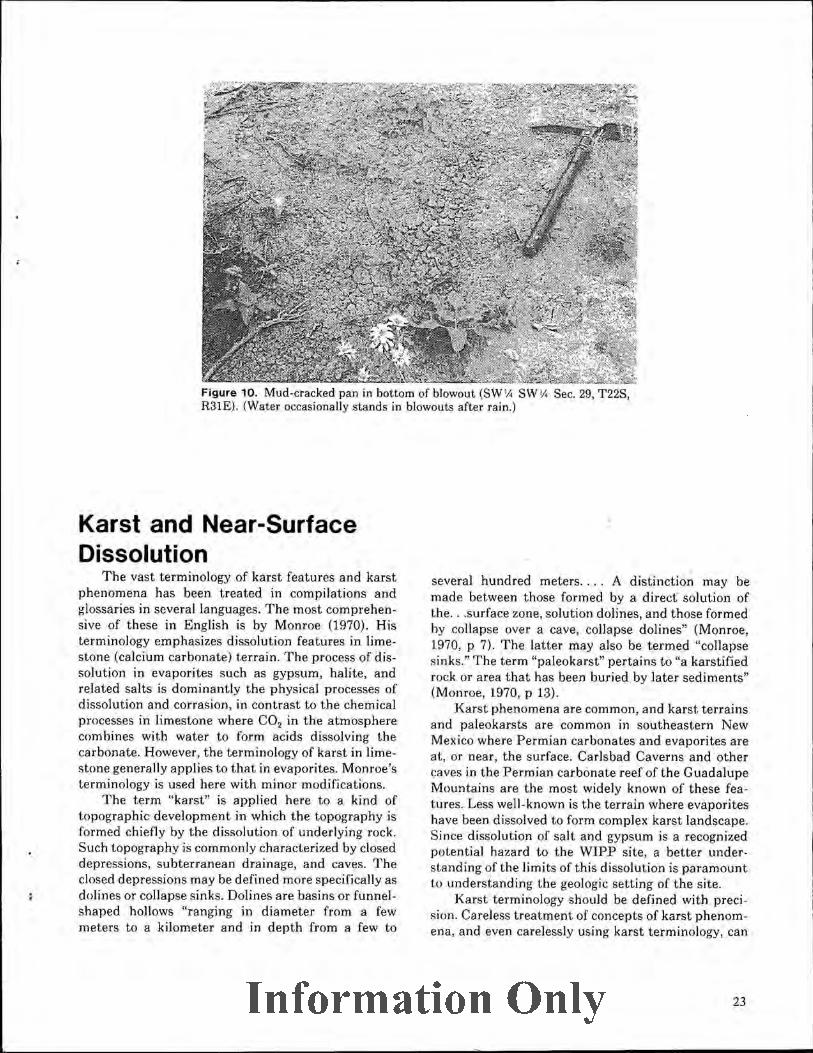
Figure 10. Mud-cracked pan in bottom of blowout (SW lA SW V. Sec. 29, T22S, R31E). (Water occasionally stands in blowouts after rain.)
Karst and Near-Surface Dissolution
The vast terminology of karst features and karst phenomena has been treated in compilations and glossaries in several languages. The most comprehensive of t hese in English is by Monroe (1970). His terminology emphasizes dissolution features in limestone (calcium carbonate) terrain. The process of dissolution in evaporites such as gypsum, halite, and related salts is dominantly the physical processes of dissolution and corrasion, in contrast to the chemical processes in limestone where C0 2 in the atmosphere combines with water to form acids dissolving the carbonate. However, the terminology of karst in limestone generally applies to that in evaporites. Monroe's terminology is used here with minor modifications.
The term "karst" is applied here to a kind of topographic development in which the topography is formed chiefly by the dissolution ·of underlying rock. Such topography is commonly characterized by closed depressions, subterranean dra inage, and caves. The closed depressions may be defined more specifically as dolines or collapse s inks. Dolines are basins or funnelshaped hollows "ranging in diameter from a few meters to a kilometer and in depth from a few to
several hundred meters .... A distinction may be made between t hose formed by a d irect solution of the ... surface zone, solution dolines, and those formed by collapse over a cave, collapse dolines" (Monroe, 1970, p 7). The latter may also be termed "collapse sinks." The term "paleokarst" pertains to "a karstified rock or area t hat has been buried by later sediments" (Monroe, 1970, p 13).
Karst phenomena are common, and karst terrains and paleokarsts are common in southeasLern New Mexico where Permian carbonates and evaporites are at, or near, the surface. Carlsbad Caverns and other caves in the Permian carbonate reef of the Guadalupe Mountains are the most widely known of t hese features. Less well-known is the terrain where evaporites have been dissolved to form complex karst landscape. Since dissolution of salt and gypsum is a recognized potential hazard to the WIPP site, a better understanding of the limits of this dissolution is paramount to understanding the geologic setting of the site.
Karst term inology should be defined with precision. Careless treatment of concepts of karst phenomena, and even carelessly using karst terminology, can
Information Only 23

contribute to misunderstanding and false impressions. The interpretation of karst activity in the vicinity of the WIPP site depends in part on understanding the distribution and physical nature of the stratigraphic units in the area. Although deep-seated dissolution has been active at localities around the periphery of the Delaware Basin in units associated with the Capitan Limestone and in the Pecos River drainage system overlying the Castile Formation (Lambert, 1983; Bachman, 1980 and 1984), deep-seated dissolution within the Delaware Basin is less probable because of physical limitations on the circulation of fresh water at depth. In contrast, dissolution of nearsurface evaporites is responsible for the visible karst features in Nash Draw and at other places at and near the WIPP site. The caves, collapse sinks, and spring deposits in Nash Draw indicate a relatively long geologic history of dissolution of gypsum and associated evaporites.
Stream gravels in the Gatuna Formation on both the east and west sides of Nash Draw indicate flowing streams across the area now encompassed by Nash Draw before it became a topographic depression (Figure 11). The Gatuiia stream system eroded into the evaporites of the Rustler Formation, and collapse sinks began to form near the end of Gatuiia time before the formation of the Mescalero caliche was well underway (Bachman, 1980). As a result of following the strike of the Rustler Formation for a time, Gatuna drainage contributed to coalescing these sinks. Thus, part of Nash Draw is a paleokarst feature. Paleokarst is prominent in Pierce Canyon -20 mi (33 km) south of the WIPP site.
In early studies of the WIPP site, dissolution of halite beds in the Rustler Formation was recognized over extensive areas beneath the Livingston Ridge surface (Jones, 1973). Halite beds are absent because of d issolution in the Rustler Formation in Nash Draw and along Livingston Ridge to the west of the site. They are absent in the Rustler above the Culebra Dolomite Member across the WIPP site itself (Mercer, 1983, p 45, Figure 13). At many drillholes where the halite beds should be present, they are represented by intervals of reddish, clayey, insoluble residues. Dissolution of halite in the Rustler appears to be related to permeability changes in the Culebra (Mercer, 1983, p 60). Increased permeability in the Culebra allows unsaturated groundwater to access, and dissolve, the halite.
Dissolution of halite, hydration of anhydrite to gypsum, and dissolution of gypsum result in local changes in thickness, in fracturing, and in forming karst features in the Rustler Formation. Field evi-
dence (Nash Draw as a topographic feature and ancient spring deposits) indicates such active processes for at least the latter half of Pleistocene time-500,000 years.
Boreholes WIPP-33 and WIPP-14 were drilled on the Livingston Ridge surface specifically to address the problem of near-surface dissolution at and near the site (SAND80-2011; SAND82-1783). Information from these and other boreholes indicates that nearsurface dissolution is most likely in proximity to Nash Draw, where evaporates in the Rustler are relatively near the surface. The dissolution of halite beds in the Rustler indicates further that the dissolution front within the Rustler is directly related to proximity to Nash Draw. Eastward from Nash Draw the front moves stratigraphically higher in the formation (Mercer, 1983, Figure 13). The easterly regional dip that plunges the Rustler deeper into the subsurface at and near the WIPP site is one factor that decreases the probability of near-surface dissolution at the site. The Dewey Lake Red Beds, which are composed of sandstone and silt, overlie the Rustler Formation at the site. These rocks do not dissolve readily, and water does not move through them freely. Karst features develop in these beds only if evaporites in the underlying Rustler are dissolved and the Dewey Lake collapses into the void.
WIPP-33 was drilled nearly 3 mi west of the center of the WIPP site (SE 1A Sec. 13, T22S, R30E) because of the presence at that locality of a small closed basin with unique characteristics. Preliminary tests by hand auger indicated more than 20 ft (6 m) of alluvial fill within the basin. In addition, the Mescalero caliche is disrupted along the rim of the basin. The Gatufia Formation is absent at that place. An arroyo - 1 mi (1.6 km) long emptying into, and disappearing in, the basin is reminiscent of the condit ions in the blind valley- a valley that ends suddenly where its stream disappears underground.
In the subsurface at WIPP-33 the Dewey Lake Red Beds are 357 ft (110 m) thick. This is an incomplete strat igraphic section that was eroded before the Mescalero caliche was deposited. The Rustler Formation, which is 276 ft (84 m) thick, is a diminutive section as compared with more complete sections where the Rustler may be as much as 450 ft (137 m) thick. This thinning of the Rustler at WIPP-33 may be attributed to dissolution of salt and gypsum; anhydrite has been hydrated to gypsum at this locality. Returns from drilling and a later video examination of the borehole indicated extensive cavities within the formation, straddling the gypsiferous Magenta dolomite member.
24 Information Only

R30E R31E 1 04°00'
T20S
32°30' + T21S
T22S
T23S
R30E
0 2
R32E 1
4 6 MILES
R33E
R32E
R34E
T20S
32°30'
T21S
T22S
T23S
R33E
.__ _ __..__ _ __._ _ ___J
Figure 11. Map showing distribution of Gatufia Formation (stippled) and probable course of streams during Gatufia time (arrows)
Borehole data from other localities at and near WIPP-33 indicate that salt and some gypsum have been dissolved from the Rustler in that area. Dissolu· tion was particularly active in the Rustler in Nash Draw. These data are the basis for indicating an approximate position of the eastern edge of the belt where halite is absent from the Rustler Formation (Figure 2).
The sp,ring deposits along the eastern edge of Nash Draw are presumed to be the result of this nearsurface dissolution. The presence of Late Pleistocene fossils in the spring deposits, and the fact that the springs are now extinct, indicate that the groundwater
regime originally responsible for dissolving underground beds of gypsum and depositing spring deposits is no longer active. That activity was part of a paleokarst system resulting from a much different climatic regime. However, dissolution of the Rustler gypsum in Nash Draw began late in Gatufia .time and is a continuing process.
WIPP-14 was drilled because of the presence of a pronounced gravity low suggesting a localized structural depression at that locality. The working hypothesis specified that the low density responsible for the gravity anomaly was due to dissolution of shallow
Information Only 25

I
'-·
-------------------··-····- '
beds, particularly in the Rustler Formation, in a m~nner analogous to that at the WIPP-33 Jocahty (SAND82-1783, pp 2-5). A minor topographic depression is present at WIPP-14, but there is no evidence of collapse at the surface.
The Gatuila Formation is absent at WIPP-14 either because of nondeposition or because of preMescalero erosion. Triassic rocks are -l26 ft (39 m) thick; the Rustler is 313 ft (96 m) thick. Halite is absent in the Rustler above the Culebra Dolomite but is present in the lower part of the Rustler underlying the Culebra. Much of the calcium sulfate in the Rustler occurs as anhydrite.
The stratigraphic succession at WIPP-14 is comparable to that in other nearby drillholes. At Drillhole WIPP-34 -0.2 mi (0.3 km) west of WIPP-14, halite was not found above the Culebra Dolomite. Likewise, in other nearby drillholes (e.g., P-5, - 1.2 mi (2 km) southwest of WIPP-14), halite is present in the Rustler only in the unit underlying the Culebra Dolomite. This indicates a regional distribution of halite that is not limited to the locality ofWIPP-14. This pattern of distribution characterizes the central portion of the WIPP site, including the WIPP shaft itself (Borns and others, 1982, p 43).
Halite may have been present formerly in the upper part of the Rustler Formation in the vicinity of WIPP-14 and WIPP-34 but has been since removed by dissolution. Such dissolution was a regional intraformational process not confined to the point at which WIPP-14 was drilled. Therefore, the hypothesis that the low density responsible for the gravity anomaly at WIPP-14 was due to the local dissolution of shallow beds is untenable. The WIPP-14 locality is not analogous to the WIPP-33 locality. At WIPP-33 halite has been removed throughout the Rustler Formation. WIPP-33 is situated in a belt along the western border of the WIPP site parallel to Nash Draw where halite is completely absent from the Rustler (Figure 2).
Holt and Powers (1984) have suggested that the extent of dissolution around the WIPP shaft -2.1 mi (3.5 km) southwest of WIPP-14 is less than previously reported. They have mapped the shaft in detail and report undisturbed depositional features in the zone originally believed to be dissolution residue (Jones, 1981). They state that "there is no disruption apparent which would be caused by volume reduction" (Holt and Powers, 1984, pp 4-11). This suggests that many structures in Rustler sediments may be explained as original depositional features. Rustler sedimentary facies and the environments of their deposition, as well as the concept of intraformational dissolution, should be reexamined in the light of this hypothesis.
Discussion and Conclusions
No attempt is made here to explain the gravity anomalies described by Barrows and others (1983) at and near the WIPP site, the anomaly that resulted in drilling WIPP-14. However, anomalous gravity data from the WIPP site and east of the approximate position of the dissolution front in the Rustler Formation (Figure 2) are probably the result of factors other than near-surface dissolution.
True karst features should not be predicted on the Livingston Ridge surface east of the indicated dissolution front in the Rustler. The pattern of the isopach maps in this report (Figures 2 and 4) suggests that dissolution of halite in the Rustler, as indicated by Mercer (1983, Figure 13) north and east of WIPP-33, probably occurred during Gatuila time. The Rustler was then within the Gatuiia drainage system and only partially protected by overlying beds. Gatufia deposits throughout southeastern New Mexico indicate that during the time of their deposition surface water was much more abundant that at any time since. Many of the results of dissolution observed today occurred during Gatuiia time, more than 500,000 yr ago.
True karst surface features contain evidence of surface collapse, such as at the WIPP-33 locality, a topographic depression .that is being actively filled by alluviation. Gypsum has been dissolved from the Rustler Formation in zones adjacent to the Magenta member at WJPP-33, leaving some subsurface cavities. This local dissolution near the eastern margin of Nash Draw is attributed to spring-sapping, as indicated by the nearby gypsite spring deposits containing camel and horse fossils. The spring-sapping and associated cliff retreat are not presently active, but probably their greatest most recent activity was contemporaneous with the now-extinct mammalian fauna. No cavities have been observed similar to those in WIPP-33 in any ne.arby potash-exploration holes to the east (or hundreds of other holes to the east); so it is here concluded that the WIPP-33 collapse feature is unique. Despite the statement of Barrows and others (1983) that "all [gravity anomalies] are assumed to have a common origin" (p 63), karstic features are by definition associated with surface collapse; not all the gravity anomalies show surface collapse or even topographic depressions. In fact, the center of one -0.8 mgal gravity anomaly is 1/4 mi (400 m) east of the WIPP-14 topographic depression, which is here interpreted as a blowout. WIPP-14 contained no subsurface cavities. Thus, the "modeled gravity ... from the infinitely long polygonal bodies [the assumed 'karst
26 Information Only

-;
conduits')" (p 63) does not provide a unique or inescapable interpretation of the gravity data, but was evidently the interpretation preferred by Barrows and others.
The absence of true surface karst features at and near the WIPP site may be explained by the depth of burial of the Rustler Formation in that area and by the protective cover of the rocks overlying the Rustler. The Rustler is at least 500 ft (152 m) beneath the surface at the site. The overlying Dewey Lake has "minimal permeability and does not contain significant quantities of ground water .... The Dewey Lake is a protective cover that retards dissolution of evaporites in the Rustler Formation" (Mercer, 1983, p 70).
Dissolution will become a major process east of WIPP-33 only if large quantities of unsaturated water gain access to the Rustler Formation. Except for minor intermittent drainages from Livingston Ridge
into Nash Draw, erosion does not appear capable of breaching the Mescalero caliche. At present, the Mescalero is an additional obstruction to infiltrating and recharging underlying beds.
Dissolution west of the indicated dissolution front in the Rustler Formation (the belt from which all halite has been dissolved from the Rustler) has occurred since late in Gatuna time (Middle Pleistocene) and continues today in Nash Draw. The area in the vicinity of WIPP-33 was above stream level and subject to erosion during Gatufla time. Dissolution at WIPP-33 is presumed to have begun then, but evidence on the surface- collapse of the Mescalero caliche and modern arroyo drainage into the collapse sink- points to post-Mescalero circulation of groundwater and consequent dissolution of remaining soluble salts. However, this modern circulation of groundwater is seasonal and probably less ·effective than during more humid Gatuiia time.
Information Only 27

References · G. 0. Bachman, "Cenozoic Deposits of Southeastern New
Mexico and an Outline of the History of Evaporite Dissolution," USGS J of Res (2):135-149 (1976).
G. 0. Bachman, Regional Geology and .Cenozoic History of Pecos Region, Southeastern New Mexico, Open~File Report 80-1099 (USGS, 1980). .
G. 0. Bachman, Regional Geology of Ochoan Evaporites, Northern Part of the Delaware Basin, Circular 184 (San~ Fe, NM: NM Bur of Mines and Minerals, 1984).
G. 0. Bachman and M. N. Machet te, Calcic Soils and Calcretes in the Southwestern United States, OpenFile Report D-77-946 (USGS, 1977).
R. A. Bagnold, The Physics of Blown Sand and Desert Dunes (London: Chapman and Hall, 1973). ·
L. J. Barrows eta!, Waste Isolation Pilot Plant (WIPP) Site Gravity Survey; and Interpretation, SAND82-2922 (Albuquerque, NM: Sandia National Laboratories, 1983).
D. J. Borns et al, Deformation of Evaporites Near the Waste Isolation Pilot Plant (WIPP) Site, SAND82-1069 (Albuquerque, NM: Sandia National Laboratories, 1983).
L. H. Gile, F. F. Peterson, and R. B. Grossman, "Morphological and Genetic Sequences of Carbonate Accumulation in Desert Soils," Soil Science 101 (5):347 -360 (1966).
L. H. Gile, J. H. Hawley, and R. B. Grossman, Soils and Geomorphology in the Basin and Range Area of South· ern New Mexico-Guidebook to the Desert Project, Memoir 39 (Santa Fe, NM: New Mexico Bureau of Mines and Mineral Resouces, 1981).
R. M. Holt and D. W. Powers, Geotechnical Activities in the Waste Handling Shaft, Waste Isola tion Pilbt Plant (WIPP) Project, Southeastern New Mexico, WTSDTME 038 (Carlsbad, NM: US DOE, 1984).
G. A. Izett and R. E. Wilcox, Pearlette Family Ash Beds in the Western United States and Southern Canada, USGS Mise lnv. Map 1-1-1325 (1982).
C. L. Jones, Salt Deposits of Los Medalios Area, Eddy and Lea Counties, NM, With Sections on Ground Water Hydrology by M. E. Cooley and Surficial Geology by G. 0. Bachman, Open-File Report 4339-7 (USGS, 1973).
C. L. Jones, Test Drilling for Potash Resources: Waste Isolation Pilot Plant Site, Eddy County, NM, OpenFile Report 78-592, 2 vol (USGS, 1978).
C. L. Jones, Geological Data for Borehole ERDA·9, Eddy County, New Mexico, Open-File Report 81-469 (USGS, 1981).
C. E. Junge and R. T . Werby, "The Concentration of Chloride, Sodium, Potassium, Calcium, and Sulfate in Rain Water over the United States," J of Meteoro115(5):417· 425 (1958) . .
S. J . Lambert, Dissolution of Evaporites In and Around the Delaware Basin, Southeastern New Mexico and West Texas, SAND 82-0461 (Albuquerque, NM: Sandia National Laboratories, 1983).
L. H. Lattman, "Calcium Carbonate Cementation of Alluvial Fans in Southern Nevada," Geol Soc Am Bull 84(9):3013-3028 (1973).
W. T .. Lee, "Erosion By Solution and Fill," USGS Bull760-D (1925).
V. C. Maley and R. M. Huffington, "Cenozoic Fill and Evaporite Solution in Delaware Basin, Texas and New Mexico," Geol Soc Am Bull 64(5):539-546 (1953).
J . W. Mercer, Geohydrology of the Proposed Waste Isola· tion Pilot Plant Site, Los Medaiios Area, Southeastern New M exico, USGS Water Res lnv Rpt 83-4016 (USGS, 1983).
W. H. Monroe, A Glossary of Karst Terminology, USGS Water Supply Paper 899 (USGS, 1970).
J . N. Rosholt, Uranium-Trend Dating of Quaternary Sedi· ments, Open-File Report 80-1087 (USGS, 1980).
J. N. Rosholt, USGS, written communication (1979).
Sandia National Laboratories and US Geological Survey, Basic Data Report for Drillhole WIPP-33, SAND80-2011 (Albuquerque, NM: Sandia National Laboratories, 1981).
Sandia National Laboratories and D'Appolonia Consulting Engineers, Basic Data Report for Drillhole WIPP·14, SAND82-1783 (Albuquerque, NM: Sandia National Laboratories, 1982).
B. J. Szabo, "Uranium-Series Dating of Quaternary Successions," Proc VIII INQUA Congress (Paris, France: 1969).
US DOE, DOE Responses to the State of New Mexico's Comments on "Summary of the Results of the Eualua· tion of the W/PP Site and Preliminary Design Valida· tion Program,~ (WIPP-DOE·l61), WJPP-DOE-174 (Albuquerque, NM: USDOE, 1983).
28 Information Only

DISTRIBUTION:
US Department of Energy, Headquarters (2) Office of Nuclear Waste Management Attn: A. Follett, Project Coordinator (WIPP)
R. Stein Washington, DC 20545
US Department of Energy (2) Albuquerque Operations Attn:. G. C. Romatowski
D. G. Jackson, Director, Public Mfairs Division PO Box 5400 Albuquerque, NM 87185
US Department of Energy (8) Att n: W. R. Cooper, WIPP Project Office,
(Carlsbad) (2) A. H unt, WPO (Carlsbad) (4) R. Crawley, WPO (Carlsbad) (2)
PO Box 3090 Carlsbad, NM 88220
US Department of Energy Carlsbad WIPP Project Office Room 113, Federal Building Ca.rlsbad, NM 88220
US Department of Energy, NPO (2) Office of Nuclear Waste Isolation Attn: Jeff 0 . Neff
R. Wunderlich 505 King Avenue Columbus, OH 43201
US Department of Energy, SRPO Office of Nuclear Waste Isolation Attn: G. Appel 505 King Avenue Columbus, OH 43201
US Nuclear Regulatory Commission (2) Division of Waste Management Attn: Michael Bell
Hubart Miller Mail Stop 697SS Washington, DC 20555
Battelle Memorial Institute (9) Project Management Division Attn: W. Carbiener, General Manager (3)
J. Treadwell T. Nayrnik J. Kirchner L. Page 0 . Swanson ONWI Library
505 King A venue Columbus, OH 43201
Westinghouse Electric Corporation (3) Attn: P. Miskimin
B. Rigney Library
PO Box 2078 Carlsbad, NM 88221
IT Corporation Attn: R. McKinney
D. Colton J. Morse
PO Box 2078 Carlsbad, NM 88221
Bechtel Inc. Attn: E. Weber
D. Roberts PO Box 3965 45-11-B34 San Francisco, CA 94119
Konrad B. Krauskopf Department of Geology Stanford University Stanford, CA 94305
FrankL. Parker Department of Environmental and
Water Resources Engineering Vanderbilt University Nashville, TN 37235
John 0. Blomeke Oak Ridge National Laboratory PO Box X Oak Ridge, TN 37830
Information Only 29

DISTRIBUTION (cont):
John D. Bredehoeft Western Region Hydrologist Water Resources Division US Geological Survey 345 Middlefield Road Menlo Park, CA 94025
Dr. Karl P . Cohen 928 N. California Avenue Palo Alto, CA 94303
Fred M. Ernsberger Adjunct Professor Department of Material Sciences and ~ngineering University of Florida Cainsville, FL 32611
Hans P. Eugster Department of Earth Sciences Johns Hopkins University Baltimore, MD 21218
Rodney C. Ewing University of New Mexico Depart ment of Geology Albuquerque, NM 87131
Charles Fairhurst Department of Geological Sciences University of Minnesota Minneapolis, MN 55455
William R. Muehlberger Department of Geological Sciences University of Texas at Austin Austin, TX 78712
D'Arcy A. Shock 233 Virginia Ponca City, OK 74601
National Academy of Sciences· Committee on Radioactive Waste Management Attn: John T . Holloway, Senior Staff Officer 2101 Constitution Avenue, NW Washington, DC 20418
Hobbs Public Library Attn: Ms. Marcia Lewis, Librarian 509 N. Ship Street Hobbs, NM 88248
New Mexico Tech Martin Speere Memorial Library Campus Street Socorro, NM 87801
New Mexico State Library Attn: Ms. Ingrid Vollenhofer PO Box 1629 Santa Fe, NM 87503
University of New Mexico Zimmerman Library Attn: Zanier Vivian Albuquerque, NM 87131
Atomic Museum, Kirtland East AFB WIPP Public Reading Room Attn: Ms. Gwynn Schreiner Albuquerque, NM 87185
Carlsbad Municipal Library WIPP Public Reading Room Attn: Lee Hubbard, Head Librarian 101 S. Hallagueno St. Carlsbad, NM 88220
Thomas Brannigan Library Attn: Don Dresp, Head Librarian 106 W. Hadley St. Las Cruces, NM 88001
Roswell Public Library Attn: Ms. Nancy Langston 301 N. Pennsylvania Avenue Roswell, NM 88201
State of New Mexico (3) Environmental Evaluation Group Attn: Robert H. Neill, Director 320 Marcy Street PO Box 968 Santa Fe, NM 87503
NM Department of Energy and Minerals (2) Attn: Larry Kehoe, Secretary
Kasey LaPlante, Librarian PO Box 2770 Santa Fe, NM 87501
30 Information Only
;

DISTRIBUTION (cont):
Dr. D. K. Mukherjee Ontario Hydro Research Lab 800 Kipling Avenue Toronto, Ontario CANADA MBZ 554
Institue fUr Tieflagerung (3) Attn: K. Ktihn
N. Jockwer H. Gies
Theodor-Heuss-Strasse 4 D-3300 Braunschweig FEDERAL REPUBLIC OF GERMANY
Michael Langer Bundesanstalt ftir Geowissenschaften und Rohstoffe Postfach 510 153
· 3000 Hannover 51 FEDERAL REPUBLIC OF GERMANY
Klaus Eckart Maass Hahn-Meitner-Institut fiir Kernforschung Glienicker Strasse 100 1000 Berlin 39 . FEDERAL REPUBLIC OF GERMANY
Rolf-Peter Randl Bundesministerium fur Forschung und Technologie Postfach 200 706 5300 Bonn 2 FEDERAL REPUBLIC OF GERMANY
Helmut Rothemeyer Physikalisch-Technische Bundesanstal t Bundesanstalt 100, 3300 Braunschweig FEDERAL REPUBLIC OF GERMANY
Kernforschung Karlsruhe (2) Attn: R. Koster
Reinhard Kraemer Postfach 3640 7500 Karlsruhe FEDERAL REPUBLIC OF GERMANY
Svensk Karnbransleforsorjning AB Project KBS Karn branslesakerhet Attn: Fred Karlsson Box 5864 10248 Stockholm SWEDEN
Tuen Deboer, Mgr. Experimental Programs Underground Storage of Radioactive Waste 3 Westerduinweg PO Box 1 1755 ZG Petten THE NETHERLANDS
Argonne National Laboratory Attn: S. Fried 9700 South Cass Avenue Argonne, IL 60439
Battelle Pacific Northwest Laboratories Attn: D. J . Bradley Battelle Boulevard Richland, W A 99352
US Nuclear Regulatory Commission (3) Division of Waste Management Attn: M. Bell Mail Stop 69755 Washington, DC 20555
IT Corporation (3) Attn: D. Stephanson
D. Shukla T. Dillon
Suite 103 2350 Alamo, SE Albuquerque, NM 87106
C. S. Fore Ecological Sciences Information Center Oak Ridge National Laboratory - Bldg. 2001 PO Box X Oak Ridge, TN 37830
John Handin Center of Tectonophysics Texas A&M University College Station, TX 77840
D. E . Large US Department of Energy Research & Technical Support Division PO Box E Oak Ridge, TN 37830
·Information Only 31

DISTRIBUTION (cont):
Paul W. Levy, Senior Scientist Brookhaven National Laboratory Associated Universities, Inc. Upton, NY 11973
Los Alamos National Laboratory Attn: B. Erda!, CNC-11 Los Alamos, NM 87545
University of Minnesota Dept. of Energy and Materials Science Attn: R. Oriani 151 Amundson Hall 421 Washington Avenue SE Minneapolis, MN 55455
Oak Ridge National Laboratory (4) Attn: R. E. Blanko
E. Bondietti C. Claiborne G. H . Jenks
BoxY Oak Ridge, TN 37830
George Pinder Department of Civil Engineering P rinceton University Princeton, NJ 08540
Dr. R. 0. Pohl Department of Physics Clark H all Cornell University Ithaca, NY 14853
RE/SPEC Inc. Attn: P . Gnirk PO Box 725 Rapid City, SO 57701
RE/SPEC, Inc. Attn: S. W. Key PO Box 14984 Albuquerque, NM 87191
Rockwell International (2) Atomics International Division Rockwell Hanford Operations Attn: M. J. Smith
W. W. Schultz PO Box 800 Richland, W A 99352
E. Roedder US Department of the Interior 959 National Center Geological Survey Reston, VA 22092
Dr. Shosei Serata Serata Geomechanics 1229 Eighth Street Berkeley, CA 94170
US Department of Energy (2) Division of Waste Products Attn: G. H . Daly
J. E. Dieckhoner Mail Stop B-107 Washington, DC 20545
New Mexico Bureau of Mines and Mineral Resources (2) Attn: F . E . Kottolowski, Director
J. Hawley Socorro, NM 87801
US Department of Energy (2) Idaho Operations Office Nuclear Fuel Cycle Division Attn: R. M. Nelson · J. Whitsett
550 Second Street Idaho Falls, ID 83401
US Department of Energy (2) Savannah River Operations Office Waste Management Project Office Attn: J. R. Covell
D. Fulmer PO Box A Aiken, SC 29801
US Geological Survey Special P rojects Attn: R. Snyder MS954, Box 25046 Denver Federal Center Denver, CO 80255
US Geological S urvey PO Box 26659 Albuquerque, NM 87125
32 Information Only
. ~
' >
DISTRIBUTION (cont):
US Geological Survey Conservation Division Attn: W. Melton PO Box 1857 Roswell, NM 88201
University of Arizona .(2) Department of Nuclear Engineering Attn: J. G. McCray
J . J. K. Daemen Tuscan, AZ 85721
Fenix & Scisson, Inc. Attn: J . A. Cross 3170 W. Sahara Avenue Spanish Oaks D-12 Las Vegas, NV 89102
University of New Mexico Geology Department Attn: D. G. Brookins Albuquerque, NM 87131
Woodward-Clyde Consultants (2) Library Western Region Attn: Anne T. Harrigan, Librarian
Charles Taylor 3 Embarcadero Center, Suite 700 San Francisco, CA 94111
Michigan Technological University Department of Social Sciences Center for Waste Management Programs Attn: G. L. Downey Houghton, MI 49931
D. W. Powers Department of Geological Sciences University of Texas at El Paso E l Paso, TX 79902
G. 0 . Bachman (10) Star Route Box 1028 Corrales, NM 87048
1540 W. C. Luth 1543 J. L. Krumhansl 3310 W. D. Burnett 6000 E. H. Beckner 6253 D. A. Northrop 6253 A. R. Sattler 6257 J. K. Linn 6257 R. R. Beasley 6300 R. W. Lynch 6310 T. 0. Hunter 6312 F. W. Bingham 6313 T. E. Blejwas 6314 J . R. Tillerson 6315 S. Sinnock 6330 W. D. Weart 6331 A. R. Lappin (5) 6331 G. E. Barr 6331 R. L. Beauheim 6331 D. J . Borns 6331 D. M. Harvey 6331 S. J. Lambert (20) 6331 W. B. Miller 6331 K. L. Robinson 6331 S. E. Shaffer 6331 C. L. Stein 6332 L. D. Tyler 6332 F. G. Yost 6332 Sandia WIPP Central Files (Dissolution) (2) 7100 C. D. Broyles 7130 J . D. Kennedy 7133 R. D. Statler 7133 C. W. Gulick 7133 J. W. Mercer 7135 P. D. Seward 8024 M. A. Pound 3141 C. M. Ostrander (5) 3151 W. L. Garner (3) 3154-3 C. H. Dalin (28)
For DOE/TIC (Unlimited Release)
Information Only 33