6 population and human health - ringaskiddyrrc.ie
TRANSCRIPT
Indaver Ringaskiddy Resource Recovery Centre
Environmental Impact Statement
EIS Ch 6 Population and Human Health | Issue 1 | January 2016 | Arup C h 6 P a g e | 1
6 Population and Human Health
Introduction
This chapter addresses potential impacts of the proposed Ringaskiddy Resource
Recovery Centre on human beings, population and human health.
The proposed development will consist principally of a waste-to-energy facility
(waste incinerator) for the treatment of up to 240,000 tonnes per annum of
residual household, commercial and industrial non-hazardous and hazardous
waste and the recovery of energy. Of the 240,000 tonnes of waste, up to 24,000
tonnes per annum of suitable hazardous waste will be treated at the facility.
In addition to the provision of the waste-to-energy facility, the proposed
development will include an upgrade of a section of the L2545 road, a connection
to the national electrical grid, an increase in ground levels in part of the site,
coastal protection measures above the foreshore on Gobby Beach and an
amenity walkway to the Ringaskiddy Martello tower.
The proposed development has the potential to impact upon population and
human health in several ways. The potential impacts on population and human
health arise from traffic, visual effects, built and natural heritage, air and noise
emissions and climate change, all of which are dealt with in the specific chapters
in this EIS dedicated to those topics. In this chapter, issues such as health and
safety, social consideration, land-use, zoning and economic activity are
examined.
Methodology
Introduction
This chapter has been prepared having regard to the following guidelines:
Revised Guidelines on the Information to be Contained in Environmental
Impact Statements (Environmental Protection Agency, draft September
2015);
Advice Notes for Preparing Environmental Impact Statements Draft
September 2015
Guidelines on the Information to be contained in Environmental Impact
Statements (EPA 2002)
Advice Notes on Current Practice in the Preparation of Environmental Impact
Statements (EPA 2003)
Guidelines for treatment of tourism in an Environmental Impact Statement
(Fáilte Ireland, 2011)
The appraisal of likely significant effects of the proposed development on
population and human beings was conducted by reviewing the current socio-
economic environment in the areas close to the proposed development. The site
is located within the Carrigaline Electoral Division. Baseline information with

Indaver Ringaskiddy Resource Recovery Centre
Environmental Impact Statement
EIS Ch 6 Population and Human Health | Issue 1 | January 2016 | Arup C h 6 P a g e | 2
respect to the demographic and employment characteristics of the resident
population within the catchment area was sourced from the 2002, 2006 and 2011
Censuses (where available). The data included information on population,
structure, age profile, and household size, number of persons at work and
unemployment profile. Information was also sourced from the following
documents/websites:
Cork County Development Plan 2014
Carrigaline Electoral Area Local Area Plan (Edition 2) 2015
Central Statistics Office (CSO) website www.cso.ie
The Department of Education and Sciences website www.education.ie
During the preparation of this EIS, consultations were held with a number of
parties in order to ensure that environmental issues, including socio-economic,
recreational and amenity issues relating to the project were addressed. The
parties consulted are listed in Appendix 1.2 of Chapter 1 Introduction of this
EIS.
Impacts on health were addressed as part of the following assessments and are
summarised in this chapter:
Hazard Identification and Risk Assessment Study (Refer to Appendix 6.1)
Health impact assessment (Refer to Appendix 6.2)
Soil dioxin and dibenzofuran (PCDD/F) monitoring programme (Refer to
Appendix 6.3)
Modelling of PCDD/F Intake for the proposed development (Refer to
Appendix 6.4)
Receiving Environment
Project Location
6.3.1.1 Site Description
The site for the Ringaskiddy Resource Recovery Centre is located approximately
15km to the south-east of Cork City, in the townland of Ringaskiddy on the
Ringaskiddy Peninsula in the lower part of Cork Harbour. The site occupies an
area of approximately 13.55 hectares and is located approximately 800m east of
the village of Ringaskiddy.
The L2545, the main road from Ringaskiddy village to Haulbowline Island, forms
the northern boundary of the site. The eastern boundary of the site extends to the
foreshore of Cork Harbour along Gobby Beach. The site surrounds the Hammond
Lane Metal Recycling Co Ltd facility. Refer to Figures 1.1 and 1.2 of Chapter 1
Introduction of this EIS which show the site location.
6.3.1.2 Immediate Vicinity
The site encircles the Hammond Lane Metal Recycling Company facility. The
facility contains several metal buildings, concrete walls, and some large pieces of
Indaver Ringaskiddy Resource Recovery Centre
Environmental Impact Statement
EIS Ch 6 Population and Human Health | Issue 1 | January 2016 | Arup C h 6 P a g e | 3
machinery. Hammond Lane expanded its facilities in 2015. There is also an ESB
Networks compound (Lough Beg substation) located adjacent to the eastern
boundary of the Hammond Lane facility. Refer to Figures 4.1 to 4.6 of Chapter 4
Description of the Proposed Development of this EIS.
The L2545 is an extension of the N28 that leads from Ringaskiddy past the
proposed development site and over the bridge to the crematorium on Rocky
Island and Haulbowline Naval base.
The Irish Maritime and Energy Research Cluster (IMERC) campus is being
developed on the northern side of the L2545 road, which forms the northern
boundary of the site. The National Maritime College of Ireland (NMCI), the first
major component of IMERC, opened in 2004. The Beaufort Research Laboratory
(construction completed in 2015), is located on the site to the east of the National
Maritime College of Ireland, will be IMERC’s second major building. Further
developments for IMERC will be located on the remainder of the land to the east
of the National Maritime College of Ireland.
Some warehouses are located on the northern side of the L2545 road, to the
west of the National Maritime College of Ireland.
The land to the immediate south of the Indaver site is owned by IDA Ireland and
is in agricultural use. Refer to Figures 4.3 to 4.6 of Chapter 4 Description of
the Proposed Development of this EIS. Just beyond the southern boundary, the
site is further visually defined by the high voltage electricity line that runs west
overhead to connect with the ESB sub-station near Shanbally and east (then
north) to Haulbowline Island. Further to the southwest, the land continues to rise
slightly to create the ridgeline on which a Martello Tower is located at the highest
point (43m OD).
The land to the west of the site is in agricultural use. Further to the west there is a
single, large, white-painted residential property (Ring House) located
approximately 50m from the site boundary, set within a field and surrounded by
trees.
The eastern section of the M28 Cork to Ringaskiddy Motorway Scheme is
proposed to cross the far western part of the Indaver site. The scheme, proposed
by Transport Infrastructure Ireland (TII) (formerly the National Roads Authority)
has not yet been published. Refer to Figure 4.7 of Chapter 4 Description of the
Proposed Development of this EIS which shows an indicative location of the
proposed M28 Cork to Ringaskiddy Motorway Scheme in the vicinity of the
Indaver site.
6.3.1.3 The Wider Area
The centre of Ringaskiddy village is located approximately 800m to the west of
the site of the proposed development. The Port of Cork’s port facilities are
located to the north of Ringaskiddy village.
The Ringaskiddy peninsula is industrial in character, with a number of
pharmaceutical companies having large manufacturing facilities in the area, in
addition to the Port of Cork facilities. The locations of some of these industries
are shown in Figures 4.3 to 4.6. Recent additions to the Ringaskiddy area
include three 100m hub-height wind turbines, located on industrial sites. A fourth

Indaver Ringaskiddy Resource Recovery Centre
Environmental Impact Statement
EIS Ch 6 Population and Human Health | Issue 1 | January 2016 | Arup C h 6 P a g e | 4
similar wind turbine has received planning permission. The DePuy wind turbine is
located to the south of the Indaver site.
The Cork Harbour area has a mixture of urban developments, such as Cobh,
Rushbrooke and Monkstown, and pockets of industry near the shore. Spike
Island is located approximately 500m to the east of the site, with the disused Fort
Mitchell prison being situated there. There is an Irish Naval Service base situated
on Haulbowline Island (refer to Figure 4.3) and a crematorium on Rocky Island.
Both islands lie to the north of the site.
Principal Potential Receptors
An appraisal of the principal potential receptors within the environs of the
proposed facility including homes, schools and commercial and industrial
premises was conducted and is detailed below.
6.3.2.1 Homes
According to the Carrigaline Electoral Area LAP 2011, the settlement of
Ringaskiddy comprises two small villages, Shanbally and Ringaskiddy. The LAP
(Section 4.7) states that there is very limited expansion potential for residential
uses because of the importance of the area for future industrial development
(2011). No land is zoned for residential development in Ringaskiddy, in the LAP.
The nearest residence is adjacent to the western boundary of the site, and will be
located approximately 400 metres from the main process building in the resource
recovery centre.
6.3.2.2 Haulbowline Naval Base
Haulbowline is an island of about 84 acres which is linked by bridge to
Ringaskiddy. Haulbowline is State property and is the headquarters of the Irish
Navy. Planning permission was granted by An Bord Pleanála to Cork Council to
develop Haulbowline Island as a public park in May 2014 (ABP reference:
MT0001).
6.3.2.3 Childcare Facilities
Ferryview Childcare Centre is located at the entrance to the Ferryview housing
estate, approximately 650m west of the site.
6.3.2.4 Health, Social, and Community Facilities
Local area facilities include the Community Centre at Ringaskiddy. Churches
located in the study area include those located at Ringaskiddy, Shanbally,
Monkstown, Passage West, Carrigaline and Cobh.

Indaver Ringaskiddy Resource Recovery Centre
Environmental Impact Statement
EIS Ch 6 Population and Human Health | Issue 1 | January 2016 | Arup C h 6 P a g e | 5
6.3.2.5 Schools and Colleges
As discussed previously IMERC and the NMCI are located across the L2545 road
from the site. Details are provided in Table 6.1 below on primary and post primary
schools located in the study area. The distances calculated are the linear
distance from entrance to the main site where the process building will be located
to the particular educational facility.
There is one primary school within Ringaskiddy Village – Ringaskiddy Lower
Harbour National School which is located within the village. Shanbally National
School is situated approximately 1.45km west of Ringaskiddy West, adjacent to
the N28.
Table 6.1 Primary and Post Primary Schools in the Area
School Type Name Address Distance from
Main Site
Primary Ringaskiddy Lr. Harbour NS Ringaskiddy 1.3 km
Primary Shanbally NS Shanbally 3.3 km
Primary Star of the Sea Passage West 4.5 km
Primary Monkstown NS Monkstown 2.7 km
Primary Rushbrooke Convent of Mercy NS Rushbrooke 2.4 km
Primary Gaelscoile Cobh Cobh 2.9 km
Primary Cobh NS Cobh 2.7 km
Primary Walterstown NS Cobh 6.2 km
Primary S N Seosamh Cobh 2.8 km
Primary St. Mary’s Convent NS Cobh 9.3 km
Primary St. Mary’s Carrigaline 5.7 km
Primary Carrigaline Boys NS Carrigaline 6.1 km
Primary St. John’s Girls NS Carrigaline 6.5 km
Primary Gaelscoil Charraig Uí Leighinn Carrigaline 5.7 km
Primary An Charraig Christian School Carrigaline 7.3 km
Primary Sonas Special Primary School Carrigaline 6.1 km
Primary Whitegate Mixed NS Whitegate 4.9 km
Primary Templebrady NS Crosshaven 3.5 km
Primary S N Bun an Tsabhairne Crosshaven 3.2 km
Post Primary Carrigaline Community School Carrigaline 5.8 km
Post Primary Coláiste Muire Crosshaven 3.4 km
Post Primary St.Peter’s Community School Passage West 4.5 km
Post Primary Coláiste Muire Cobh 2.7 km
Post Primary Cobh Community School Cobh 2.9 km

Indaver Ringaskiddy Resource Recovery Centre
Environmental Impact Statement
EIS Ch 6 Population and Human Health | Issue 1 | January 2016 | Arup C h 6 P a g e | 6
Heritage and Amenity
6.3.3.1 Heritage
Archaeological, architectural and cultural heritage are discussed in Chapter 14
Archaeological, Architectural and Cultural Heritage of this EIS. In summary,
there are no recorded archaeological sites, no cultural heritage sites and no
protected structures within the proposed development site. A Martello tower,
listed in the Record of Monuments and Places, (RMP No. CO087-053---) and
listed in the Record of Protected Structures (RPS 00575) stands approximately
70m to the south of the proposed development site. Refer to Chapter 14 for
further details.
Ordnance Survey maps show that a path once led north-east through the
proposed development site from the Martello tower to the sea shore at the
eastern end of the Ringaskiddy peninsula. Refer to Chapter 14 for further details.
Anecdotal evidence suggests that the site was used as a source of material for
land reclamation elsewhere in Ringaskiddy, and that this accounts for the steep
escarpment running east-west within the site. Although it is shown on historic
maps, much of the path is no longer in existence, most likely due to the removal
of soil in the past. There is no legal registered right-of-way along this path.
A farm track runs through waste-to-energy side of the site (east of Hammond
Lane) from the L2545 to the southern boundary of the site. Although there is no
legal registered right-of-way, the site appears to be used very occasionally as a
pedestrian link between the shore and the Martello Tower.
Nature Conservation Areas are discussed in Chapter 12 Biodiversity of this
EIS. In summary, there are no environmental designations located within the site
of the proposed development. The majority of the site is currently covered in
scrub with some pockets of trees and open grass areas. Gobby Beach is located
along the eastern boundary of the site. Cork Harbour Special Protection Area
(SPA) is located 0.5km to the south of the site. Refer to Chapter 12 for further
details.
Geological Heritage Sites (GHSs) are discussed in Chapter 13 Soils, Geology,
Hydrogeology, Hydrology and Coastal Recession of this EIS. In summary,
there are no Geological Heritage Sites (GHS) located within the site of the
proposed development. There are two GHS sites in the general vicinity of the
site. These are Golden Rock, located approximately 400m southeast and Lough
Beg section, located approximately 1.4km south of the site. Refer to Chapter 13
for further details.
Scenic routes and designated landscapes are discussed in detail in Chapter 11
Landscape and Visual Assessment of this EIS. In summary, there are some
scenic routes and scenic landscape designations in close proximity to the site in
the (Cork County Development Plan 2014). Refer to Chapter 11 for further
details.
6.3.3.2 Local Amenity
From a local amenity viewpoint, the N28 road which passes through Ringaskiddy
Village is a busy road carrying port and industrial traffic twenty-four hours per
Indaver Ringaskiddy Resource Recovery Centre
Environmental Impact Statement
EIS Ch 6 Population and Human Health | Issue 1 | January 2016 | Arup C h 6 P a g e | 7
day. The road is the National Primary Route N28. It passes eastwards through
Ringaskiddy Village as far as the junction with the entrance to the ferry port and
the main road to Loughbeg, and continues eastwards as the L2545 past the
Indaver site as the access road to Hammond Lane, the crematorium at Rocky
Island, the National Maritime College of Ireland, the Beaufort Laboratory, the
Naval Base on Haulbowline Island and Gobby beach.
Cork County Council, in association with Transport Infrastructure Ireland (TII)
(formerly the NRA), plans to construct a new N28 dual carriageway road from the
Bloomfield Interchange near Douglas to Ringaskiddy. This road which is currently
being designed, will serve the future traffic needs of the area while removing
traffic from Shanbally and Ringaskiddy Villages. The timeframe for construction of
this road remains to be confirmed. The eastern section of the M28 Cork to
Ringaskiddy Motorway Scheme is proposed to cross the far western part of the
Indaver site.
The sandy/rocky shore at the eastern end of the peninsula at Ringaskiddy is
known as Gobby beach. This beach is a local amenity served by a small public
car park (Gobby Beach car park) and is frequently used by local residents for
walking. There is a footpath to the Martello Tower from the main Ringaskiddy to
Loughbeg Road. As discussed in Section 6.3.3.1 above, the site appears to be
used very occasionally as a pedestrian link between the shore and the Martello
Tower.
The deep water berth at Ringaskiddy is one of Cork Harbour’s premier shore
fishing locations. During the winter months, bottom fishing will produce Flatfish,
Whiting and Codling. Ray is caught during the summer, while Coalfish and
Conger can be caught all year round. Fishing is also carried out from the shore at
Gobby beach.
Local sports clubs include Raffeen Creek Sports Club in Ringaskiddy which
comprises Raffeen Creek Golf Club, Raffeen Creek Pitch and Putt Club and two
soccer pitches. Shamrocks Hurling and Football Club is located in Shanbally,
near Ringaskiddy. The Hibernian Soccer Club is also based in Shanbally.
Haulbowline Island is identified as an East Cork Bird Trail Hotspot. A bird reserve
is located at Loughbeg.
The Ringaskiddy and District Residents Association received a grant of planning
in 2014 for the construction of a community children’s playground on a site
adjacent to the N28 in Ringaskiddy Village.
In 2015, the Port of Cork received permission from An Bord Pleanála, for an
expansion project, which includes for new public pier, slipway and boarding
platform at Paddy’s Point.
The East Tip, part of the Former Ispat Steelworks on Haulbowline Island, has
planning permission and a waste licence for remediation works and
redevelopment as a public park. An overall development master plan for the
entire Island is currently being developed.
Cork County Council published a master plan for Spike Island in 2012. The
master plan proposes that the Island is developed as a tourist and amenity
destination with improved access, ferry links to other locations in the harbour,
redevelopment of the existing buildings for compatible new uses, construction of

Indaver Ringaskiddy Resource Recovery Centre
Environmental Impact Statement
EIS Ch 6 Population and Human Health | Issue 1 | January 2016 | Arup C h 6 P a g e | 8
walking and cycling paths, an adventure centre, a retreat centre, a camp site and
extensive landscaping. Limited tourist accommodation has been proposed. Spike
Island is separated from the Indaver site by a channel (West Channel) which is
circa 700m wide.
6.3.3.3 Amenity in Cork Harbour
There is extensive recreational use of Cork Harbour, mainly the Lower Harbour,
for sea angling and boating. Leisure and recreational activities within the Harbour
and its immediate surrounds include sailing, rowing, windsurfing, canoeing,
angling, bird watching, swimming and walking. Sailing is a popular amenity in
Cork Harbour and there are several sailing/yacht clubs in the Harbour including
Lower Aghada Tennis and Sailing Club, East Ferry Marina, Cobh Sailing Club,
Monkstown Bay Sailing Club and Royal Cork Yacht Club, which is in Crosshaven.
Meitheal Mara is a maritime cultural organisation based in Cork. It was founded in
1994 as a community employment Currach building project and frequently uses
the harbour for boating activities. Meitheal Mara organises the annual Ocean to
City Race for rowing boats and canoes.
Typically, boats use the main shipping channel (known as Cobh Road) which
runs north of Haulbowline Island and Spit Bank, and north and east of Spike
Island. Leisure craft including sailing and motor boats use the West Channel on
occasion but there are depth restrictions due to the shallow nature of the channel
and the presence of Curlane Bank to the south and Spit Bank to the north.
Depths range from 0.2m to 5.9m (Chart Datum) and the channel is too shallow to
be used as a shipping channel. Sailing race courses around the harbour pass in
close proximity to Spike Island and there is an annual sailing race around Spike
Island. The race takes place during the summer at a high tide (preferably spring
tide) when there is enough depth in the channel for larger boats such as cruisers.
Other annual sailing races in the Harbour include Cork Week, which is held every
two years..
The Monkstown and Cork Harbour Rowing Club is based in Monkstown. Irish
Coastal Rowing Federation Clubs which utilise Cork Harbour include
Rushbrooke, Passage West, Commodore, Crosshaven, Blackrock, East Ferry,
Cobh Fishermen, Maritime College and Naval Service rowing clubs.
Fota Estate, Fota House and Arboretum, Fota Wildlife Park, Fota Island Hotel
and Spa and Fota Golf Club are situated on Fota Island, in the Upper Harbour.
Other golf clubs around the Harbour area include Monkstown and Cork Golf
Clubs.
Amenities in Passage West and Monkstown include a sea front walk which runs
north to Hop Island, and a children’s playground which is located in Passage
West. The children’s playground was built in Ringaskiddy in 2014.

Indaver Ringaskiddy Resource Recovery Centre
Environmental Impact Statement
EIS Ch 6 Population and Human Health | Issue 1 | January 2016 | Arup C h 6 P a g e | 9
Economic Activity
6.3.4.1 Tourism
In 2011, Fáilte Ireland published Guidelines on the treatment of tourism in an
Environmental Impact Statement, noting that there are two interactions between
tourism and the environment:
Impacts caused by tourism projects (e.g. marinas and holiday villages)
Impacts affecting tourism (e.g. the quality of a destination or a tourism
activity).
The Guidelines note that the assessment of effects on tourism should be treated
as a specialist sub-section of the topic ‘Population and Human Health’, with
particular elements being considered, as appropriate within other sections, e.g.
Landscape, Flora and Fauna and Cultural Heritage etc. Chapter 3 of the
Guidelines list a number of factors – in order of priority are the reasons why
tourists visit and enjoy Ireland. These factors have been considered where
relevant in various sections of this EIS as follows:
Table 6.2 Reasons why tourists visit and enjoy Ireland in order of priority
(according to the Guidelines). These are addressed in the relevant sections of this
EIS
Factor EIS Chapters / Notes
Beautiful scenery Landscape and Visual (Ch 11)
The guidelines note that “there appears to be evidence that the
visitors expectation of ‘beautiful scenery’ does not exclude an
admiration of new modern developments – such as windfarms-which
appear to be seen as indicative of a modern informed and responsible
attitude to the environment”
Friendly & hospitable
people
The guidelines note that “this is not an environmental factor though it
is indirectly covered under the ‘Human Beings’ section of the EIS”.
Refer to Section 6.3.4 for demographic details.
Safe & Secure
The Guidelines note that “this is not an environmental issue though
some of the factors that are sometimes covered under the heading of
‘Human Beings’ – such as social inclusion or poverty – can point to
likely effects and interactions”. Refer to Section 6.5.3 for details on the
HAZID assessment
Easy, relaxed pace of
life
The Guidelines note that “this is not an environmental issue though it
is partially covered under ‘Human Beings’ see comments above”.
Refer to 6.3 on receiving environment.
Unspoilt environment Biodiversity (Ch 12), Landscape and Visual (Ch 11). Emissions are
addressed in Air Quality (Ch 8), Climate (Ch9), Noise and Vibration
(Ch10), Soils, Geology, Hydrology, Hydrogeology and Coastal
Recession (Ch13) and Material Assets (Ch 15). Traffic is addressed in
Roads and Traffic (Ch 7)
Nature, wildlife, flora Biodiversity (Ch 12), Landscape and Visual (Ch 11)
Emissions are addressed in Air Quality (Ch 8), Climate (Ch9), Noise
and Vibration (Ch10), Soils, Geology, Hydrology, Hydrogeology and
Coastal Recession (Ch13) and Material Assets (Ch 15). Traffic is
addressed in Roads and Traffic (Ch 7)
The guidelines note that “this topic also considers the effect on
physical access to and visibility of these sites”. Access to Gobby

Indaver Ringaskiddy Resource Recovery Centre
Environmental Impact Statement
EIS Ch 6 Population and Human Health | Issue 1 | January 2016 | Arup C h 6 P a g e | 10
Factor EIS Chapters / Notes
Beach during construction is addressed in Construction (Ch 5).
Visibility is addressed in Landscape and Visual (Ch 11).
Interesting history and
culture
Landscape and Visual (Ch 11) and Cultural heritage (Ch 14). The
guidelines note that “the principal issues are to avoid damage to sites
and structures of cultural, historical, archaeological or architectural
significance – and to their contexts or settings. It also considers the
effect on physical access to and visibility of these sites” Access and
visibility to Martello tower is addressed in Landscape and Visual (Ch
11) and Cultural heritage (Ch 14).
Good range of natural
attractions
Biodiversity (Ch 12), Landscape and Visual (Ch 11) and Cultural
Heritage (Ch 14)
Plenty of things to see
and do
The Guidelines note that “this is not an environmental issue though it
is partially covered by the Human Beings section, where tourism
resources of an area are described and assessed. Refer to Section
6.3.2 for details on heritage and amenity
Although Ringaskiddy is not currently a popular tourist destination, it is, and is
expected to remain, an important tourist transit port.
Brittany Ferries operates a weekly car ferry service between Ringaskiddy and
Northern France from April to October inclusive. A ferry with the capacity to
transport 2,400 passengers arrives and departs from Ringaskiddy every
Saturday. The deep water berth at Cobh has the capacity to handle very large
cruise ships. Occasionally there are two or even three cruise ships in the
Harbour. If the Cobh cruise ship berth is occupied, the other cruise ship or ships
dock at Ringaskiddy. Approximately 60 cruise ships a year visit the Harbour.
The cruise ships make a significant contribution to the local economy.
The lower harbour contains a number of important military fortifications such as
Spike Island, Fort Davis, Fort Camden, Cobh Fort and Ringaskiddy Martello
tower, which contribute to the rich heritage and character of the harbour. Though
Ringaskiddy itself is not a tourist destination, strategic plans are being prepared
to develop the area as a more significant tourism and recreational attraction.
There are already regular tours from Cobh to the military fortification on Spike
Island. The Spike Island master plan proposes that the Island is developed as a
tourist and amenity destination with improved access, ferry links to other
locations in the harbour, redevelopment of the existing buildings for compatible
new uses, construction of walking and cycling paths, an adventure centre, a
retreat centre, a camp site and extensive landscaping. Limited tourist
accommodation has been proposed.
The Port of Cork facility is likely to undergo considerable change in the coming
years, as permission has recently been granted for significant expansion of the
facility, including the development of an amenity boat launch facility at Paddy’s
Point adjacent Haulbowline Bridge and Beaufort building. The Port of Cork’s
planning permission included a walkway along the northern shoreline. Similarly,
both the imminent rehabilitation of the East Tip Island to a parkland landscape for
amenity purposes, and the potential redevelopment of the former ISPAT/Irish
Steel on Haulbowline Island and the proposed installation of an additional wind
turbine at DePuy’s plant at Loughbeg (planning application recently submitted to
Cork County Council) will be forces of change in the landscape and visual
environment of the Lower Harbour area.
Indaver Ringaskiddy Resource Recovery Centre
Environmental Impact Statement
EIS Ch 6 Population and Human Health | Issue 1 | January 2016 | Arup C h 6 P a g e | 11
6.3.4.2 Commercial and Industrial Premises
The majority of the Indaver site is zoned for industrial use designated as a
Strategic Employment Area in the Carrigaline Local Area Plan 2011. Refer to
Figure 2.3 of Chapter 2. A small section of the overall Indaver site (located along
the far western boundary of the site) includes lands zoned as open space, which
characterises an area of open space that acts as a buffer between proposed
industry and established uses. The zoning objective in the LAP states that while
the patterns of land use will remain largely unchanged, if the adjoining land
designated for industry is developed, consideration will be given to landscaping
including strategic tree planting on the land.
Section 6.4.11 of the Cork County Development Plan 2014-2020 states that “the
provision of strategic large scale waste treatment facilities will be considered in
‘Industrial Areas’ designated as Strategic Employment Areas in the local area
plans subject to the requirements of National Policy, future Regional Waste
Management Plans and the objectives set out in local area plans”.
A considerable area of land in Ringaskiddy, including most of the site, is zoned
for industrial development. IDA Ireland owns part of the industrial zoned land,
with the remainder in private and Port of Cork ownership. IDA Ireland includes
the Ringaskiddy area in its ongoing promotion of industrial development.
Ringaskiddy is a significant centre of pharmaceutical manufacture at an
international level. Since the late 1960s, some very large pharmaceutical
manufacturing plants have been constructed in the area. Other businesses in the
area include car importers, electronics manufacturing, and grain, cement and
molasses storage. Commercial service companies in Ringaskiddy include a small
convenience shop, a public house and a public house/restaurant on the main
street of Ringaskiddy Village.
The Port of Cork, initially as Cork Harbour Commissioners, has been developing
the Ringaskiddy port facilities since the early 1980s. The Port of Cork Company
has a throughput of approximately 10 million tonnes per annum of cargo, and
there are extensive port facilities in the Harbour. The Port of Cork estimates that
1,252 commercial ships entered the harbour in 2012. The Company operates a
container and ferry port at Ringaskiddy. Its deepwater berth at Ringaskiddy is of
major economic importance to the region. Facilities at the deepwater berth can
handle a range of cargo types, including roll-on roll-off, lift-on lift-off and dry bulk.
Cargo ships service the Tivoli Container Port, approximately 6km to the north
west of the site.
As discussed above, Port of Cork has received permission to redevelop its
facilities at Ringaskiddy Port, Port of Cork proposes, on a phased basis, to
transfer cargo handling activities from Tivoli and City Quays to Ringaskiddy in
due course.
The land use and development policy for the Ringaskiddy area is for this
industrial and port development to continue.
6.3.4.3 Commercial Fisheries
Vessels more than 12m in length are not permitted to fish within Cork Harbour.
Vessels fish mainly out of Cobh and Crosshaven. Boats are engaged in potting
Indaver Ringaskiddy Resource Recovery Centre
Environmental Impact Statement
EIS Ch 6 Population and Human Health | Issue 1 | January 2016 | Arup C h 6 P a g e | 12
for lobster, edible or brown crab, Velvet crab and the common shore or green
crab. Shrimp are also potted extensively in late summer and autumn. A limited
amount of mullet fishing takes place during the summer months and trawling
takes place, particularly later in the year for codling and flat fish. The channel
between Spike Island and the Ringaskiddy shore is occasionally used as a
trawling route for boats fishing for species such as plaice, skate and flounder
when the conditions outside the harbour are too inclement for fishing. The edges
of the channel below the low water mark are used for potting for Green Crab,
Velvet Crab and Shrimp.
Occasional scallop fishing is undertaken south of Cuskinny on the southern shore
of Great Island. Potting is undertaken extensively from inside the Dognose Bank
(Fort Davis/Carlisle) along the rocky coast on the eastern side of the Lower
Harbour. Up to 2,000 pots can be laid in this area at any one time and in general
the area is considered very productive for all potted species. Potting for Shrimp,
Crab and Lobster is also undertaken along the Great Island shore, east of
Cuskinny, and to a limited extent in the East Ferry channel. Green crab is also
fished in the North Channel, north of Great Island.
Trawling is undertaken in several places around the harbour especially along the
shelf bordering the main channels.
Netting for Mullet is undertaken around Aghada, mainly during the summer.
Over-fishing is a threat to all fisheries and responsible management and
conservation of the resources are required if long-term sustainability is to be
ensured. In light of this, Lobster conservation measures have been adopted by
the Cork Harbour fishermen in line with their counterparts around the Irish Coast.
6.3.4.4 Aquaculture
Mussel culture is totally banned in Cork Harbour because of the prevalence of the
organisms that cause Paralytic Shellfish Poisoning. Oysters are the main species
cultivated. There is a licence for oyster farming in force in the eastern part of the
Harbour, approximately east of a line from Long Point to Cuskinny.
Great Island North is one of 63 designated shellfish growing sites around the Irish
coastline. This designation requires minimum standards of water quality to be
maintained. It also obligates public authorities to report information relevant to
water quality in designated areas to the Department of the Environment, Heritage
and Local Government.
Demographics
6.3.5.1 Recent Trends in Population
The smallest geographical units distinguished by the Central Statistics Office
(CSO) are Electoral Divisions.
Local electoral areas were reconfigured in 2014 following recommendations
made by the Local Electoral Area Boundary Committee. Population statistics
have not been gathered or categorised using the new electoral districts to date.

Indaver Ringaskiddy Resource Recovery Centre
Environmental Impact Statement
EIS Ch 6 Population and Human Health | Issue 1 | January 2016 | Arup C h 6 P a g e | 13
The sections below are based on the pre-2014 electoral districts for which
population data is available.
Prior to 2014, the Indaver site was located in the Carrigaline Electoral Division
within The Cork Rural Area. The Cork Rural area comprised 30 Electoral
Divisions and constituted the wider hinterland surrounding the site (excluding
Cork City). Under the revised Electoral Area boundaries, the Indaver site is
located within the Carrigaline Electoral Division within the Ballincollig-Carrigaline
Electoral Area. The Ballincollig-Carrigaline Electoral Area is comprised of eight
Electoral Divisions in total.
Table 6.3 outlines the population change between 2006 and 2011 and the growth
rate of these population figures.
Table 6.4 outlines the population change and growth rate of the main towns near
Ringaskiddy between 2006 and 2011.
Table 6.3 Population of State, County Cork, Cork City, Cork Rural Area and
Carrigaline Electoral Division 2002-2011
District 2006 2011 Change from
2006-2011
(%)
State 4,239,848 4,588,252 +8.2
Cork (County and City) 481,295 519,032 +7.8
Cork County 361,877 399,802 +10.5
Cork City 119,418 119,230 -0.2
Cork Rural Area 119,520 131,100 +9.7
Carrigaline (Electoral Division No 82) 10,969 11,818 +7.7
(Data source: CSO website www.cso.ie)
Cork Rural Area includes Carrigaline Electoral Division (No 82) within which
Ringaskiddy village is located.
Table 6.4 Population of Main Towns near Ringaskiddy 2002-2011
District 2006 2011 Change from
2006-2011
(%)
Cork City 119,418 119,230 -0.2
Cork Suburbs 70,966 79,352 +11.8
Carrigaline Town (including)
Ringaskiddy
12,835
514
14,775
478
+15.1
-7.0
Cobh Town and environs 11,303 12,347 +9.2
Passage West and environs 5,203 5,790 +11.3
Crosshaven 1,669 2,093 +25.4
Total 221,394 223,587 +5.5
(Data source: CSO website www.cso.ie)
Note: ‘Carrigaline Town’ comprised 3 Electoral Divisions (No.82 in Cork Rural Area and No.s 183 &
193 in Kinsale Rural Area). Ringaskiddy was included in the count for Carrigaline Town because it
formed part of Carrigaline Electoral Division No 82. Cobh Town and environs comprises Cobh

Indaver Ringaskiddy Resource Recovery Centre
Environmental Impact Statement
EIS Ch 6 Population and Human Health | Issue 1 | January 2016 | Arup C h 6 P a g e | 14
Urban Electoral Division and part of Cobh Rural Electoral Division. Passage West Town and
environs comprised Monkstown Urban Electoral Division and part of Monkstown Rural Electoral
Division. Crosshaven Town formed part of Templebreedy Electoral Division (Kinsale Rural Area).
The populations of the towns in the area increased in the period.
6.3.5.2 Household Size
Table 6.5 below outlines the average household size in each of the geographical
areas assessed. The statistics illustrate an increase in household size from 2006
to 2011, contrary to the national trend which was a decrease in household size.
However, the household size in the area of the proposed development
(Carrigaline Electoral Division) is still higher than the State, City and County for
2006.
Table 6.5 Average Household Size (persons per household)
District 2006 2011
State 2.81 2.70
Cork County 2.88 2.80
Carrigaline Electoral Division 2.96 Not available
(Data source: CSO website www.cso.ie)
6.3.5.3 Age Profile
Table 6.6 below outlines the age profile of the population in terms of dependent
age cohorts (0-14 and 65+) and working age cohorts (15-64) over a five year
period between 2006 and 2011. The statistics show that in 2006 a below-average
proportion within the dependant age groups resided in Carrigaline Electoral
Division (29.3%) compared to the State (31.4%). A higher percentage (51.7%) of
the population in the Carrigaline Electoral Division fall within the childbearing age
group compared to the State (46.6%) in 2006.
Table 6.6 Population of each catchment categorised into independent, dependent
and childbearing cohorts 2002-2011
District 0-14 & 65+ yrs
Dependent (%)
15-64 yrs
independent (%)
15-44 yrs
childbearing (%)
State 2006 31.4 68.6 46.6
State 2011 33.2 66.9 44.3
Cork County 2006 32.3 67.7 45.5
Cork County 2011 34.1 65.9 42.7
Carrigaline ED 2006 29.3 70.7 51.7
Carrigaline ED 2011 Not available Not available Not available
(Data source: CSO website www.cso.ie)
Table 6.7 shows the age cohorts for 2011 across the State, Cork City, Cork
County and Carrigaline Town. The statistics were not available for the Carrigaline
Electoral Division in this format.
Statistics show Carrigaline Town has an above average proportion aged 0-14
(27.2%) compared to the State (21.3%), Cork City (14.7%) and Cork County

Indaver Ringaskiddy Resource Recovery Centre
Environmental Impact Statement
EIS Ch 6 Population and Human Health | Issue 1 | January 2016 | Arup C h 6 P a g e | 15
(21.1%). The 2011 statistics show that Carrigaline Town also has an above
average proportion aged 25-44 (35.6%) compared to the State (31.6%), Cork City
(30.6%) and Cork County (31.2%).
Table 6.7 Age cohort 2011
District 0-14 15-24 25-44 45-64 65+ Total
State 2011 21.3% 12.6% 31.6% 22.7% 11.7% 4,588,252
Cork City 2011 14.7% 16.8% 30.6% 22.9% 15.1% 119,230
Cork County 2011 21.1% 12.6% 31.2% 23.1% 12% 519,032
Carrigaline Town 2011 27.2% 11.6% 35.6% 20.2% 5.3% 14,775
Carrigaline ED 2011 Not available in this format 11,818
(Data source: CSO website www.cso.ie)
Table 6.8 shows age cohorts for Carrigaline Town for 2006 and 2011. The
proportion of people aged 0-14 in Carrigaline Town increased between 2006 and
2011 from 25.5% to 27.2%.
Table 6.8 Age cohort for Carrigaline Town 2006 - 2011
District 0-14 15-24 25-44 45-64 65+ Total
Carrigaline Town 2006 25.5% 13.6% 38% 18.4% 4.5% 12,835
Carrigaline Town 2011 27.2% 11.6% 35.6% 20.2% 5.3% 14,775
(Data source: CSO website www.cso.ie)
In summary, it is evident that Carrigaline Town and Electoral Division has a
young and growing population. Carrigaline Electoral Division has a below
average proportion of people within the dependant age groups, an above
average proportion within the working and childbearing groups, and a household
size slightly above the State average as seen in the 2006 statistics.
Recent Trends in Employment
Recent trends in employment were evaluated using CSO information generated
from the 2006 and 2011 Censuses and Small Area population statistics. The
information was compiled on the basis that:
The labour force is defined as the sum of people aged 15 years and over who
are at work or who are employed.
The participation rate is the proportion of persons in the labour force aged 15
years and over expressed as a percentage of all persons in that age group.
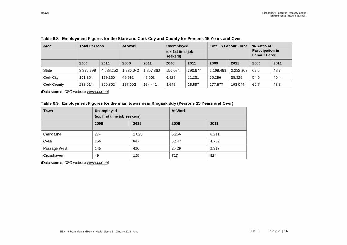
Statistics shown in Tables 6.8 and 6.9 below outline the employment figures for
the State, Cork City and Cork County, and in the main towns near Ringaskiddy,
respectively
Tables 6.8 and 6.9 show that there was a decrease in the total number of
persons aged 15 years and over at work in the State and in Cork City and County
in the period 2006-20011. Percentage rates of participation in the labour force
also decreased during the same period.
Indaver Ringaskiddy Resource Recovery Centre
Environmental Impact Statement
EIS Ch 6 Population and Human Health | Issue 1 | January 2016 | Arup C h 6 P a g e | 16
Table 6.8 Employment Figures for the State and Cork City and County for Persons 15 Years and Over
Area Total Persons At Work Unemployed
(ex 1st time job
seekers)
Total in Labour Force % Rates of
Participation in
Labour Force
2006 2011 2006 2011 2006 2011 2006 2011 2006 2011
State 3,375,399 4,588,252 1,930,042 1,807,360 150,084 390,677 2,109,498 2,232,203 62.5 48.7
Cork City 101,254 119,230 48,892 43,062 6,923 11,251 55,296 55,328 54.6 46.4
Cork County 283,014 399,802 167,092 164,441 8,646 26,597 177,577 193,044 62.7 48.3
(Data source: CSO website www.cso.ie)
Table 6.9 Employment Figures for the main towns near Ringaskiddy (Persons 15 Years and Over)
Town Unemployed
(ex. first time job seekers)
At Work
2006 2011 2006 2011
Carrigaline 274 1,023 6,266 6,211
Cobh 355 967 5,147 4,702
Passage West 145 426 2,429 2,317
Crosshaven 49 128 717 824
(Data source: CSO website www.cso.ie)
Indaver Ringaskiddy Resource Recovery Centre
Environmental Impact Statement
EIS Ch 6 Population and Human Health | Issue 1 | January 2016 | Arup C h 6 P a g e | 17
National Quarterly Household Survey
The National Quarterly Household Survey Statistics for the third quarter (July to
September) of 2015 show that there were 1,983,000 persons in employment in
the State during that quarter, which is an annual increase of 56,000 persons or
+2.9%. There were 203,000 persons unemployed in the third quarter of 2015, a
decrease of 42,500 in the year. Overall, the labour force in the State increased by
13,500 or +0.6% over the year to 2,186,000 in the year (CSO, 2015.
Employment in the construction sector increased by 15,000 or +13.3% in the year
to the third quarter to 2015.
The following table shows the distribution of employment sectors in 2011 in towns
near Ringaskiddy. Manufacturing and wholesale and retail trade are significant
employment groups in the area.
Table 6.11 Distribution of employment by broad industrial group in towns near
Ringaskiddy (number of persons aged 15 years and over) 2011
Cobh Passage
West
Crosshaven Carrigaline
Agriculture, forestry and fishing 18 17 10 34
Mining and quarrying 3 2 1 2
Manufacturing 797 333 104 1,176
Electricity, gas, steam and air
conditioning supply
40 30 7 58
Water supply; sewerage, waste
management and remediation
activities
11 11 9 33
Construction 195 129 55 347
Wholesale and retail trade; repair of
motor vehicles and motorcycles
682 348 117 1,006
Transportation and storage 234 86 21 262
Accommodation and food service
activities
301 140 36 304
Information and communication 121 97 35 203
Financial and insurance activities 120 86 28 251
Real estate activities 10 20 1 17
Professional, scientific and technical
activities
227 156 66 377
Administrative and support service
activities
164 103 32 270
Public administration and defence;
compulsory social security
535 124 48 348
Education 340 213 85 552
Human health and social work
activities
412 253 76 535
Arts, entertainment and recreation 91 36 20 76
Other service activities 135 54 27 146

Indaver Ringaskiddy Resource Recovery Centre
Environmental Impact Statement
EIS Ch 6 Population and Human Health | Issue 1 | January 2016 | Arup C h 6 P a g e | 18
Cobh Passage
West
Crosshaven Carrigaline
Activities of households as employers
producing activities of households for
own use
5 4 1 10
Activities of extraterritorial
organisations and bodies
- - 1 -
Other Industry 261 75 44 204
Total 4,702 2,317 824 6,211
Characteristics of Proposed Development in the context of Population and Human Health
The proposed development will consist principally of a waste-to-energy facility
(waste incinerator) for the treatment of up to 240,000 tonnes per annum of
residual household, commercial and industrial non-hazardous and hazardous
waste and the recovery of energy. Of the 240,000 tonnes of waste, up to 24,000
tonnes per annum of suitable hazardous waste will be treated at the facility.
The proposed development will generate additional traffic, and noise and air
emissions, which will be within the applicable emission limits. No process or
sanitary effluent will be discharged to Cork Harbour. Emissions from the facility
are addressed in the relevant sections of the EIS.
Up to 320 people will be directly employed during the construction phase. Up to
63 people will be directly employed during the operational phase.
In addition to the provision of the waste-to-energy facility, the proposed
development will include an upgrade of a section of the L2545 road, a connection
to the national electrical grid, an increase in ground levels in part of the site,
coastal protection measures above the foreshore on Gobby beach and an
amenity walkway to the Ringaskiddy Martello tower.
The L2545 upgrade will reduce flood risk on the road which will be of benefit both
to the Ringaskiddy Resource Recovery Centre and also to the other existing
users of this road including IMERC, NMCI, the crematorium on Rocky Island and
the Naval Base on Haulbowline Island. Future development of Haulbowline as a
public park will also benefit due to the improved upgrade of the L2545. The
increase in ground levels in part of the Indaver site will reduce flood risk.
A new bitumen macadam footpath will be constructed to give access from Gobby
Strand to the Martello Tower. It is proposed to run along the eastern edge of the
site and will be fenced with a low timber fence along the eastern edge. A viewing
area will be provided at the higher south east corner of the site providing
expansive views over Cork harbour, Spike Island and Cobh.
Coastal protection in the form of sacrificial material is proposed above the
foreshore along the section of Gobby Beach owned by Indaver in order to slow
the rate of coastal recession.
It is expected that, if granted planning permission, Indaver would be required to
establish a community gain fund to fund environmental and other community

Indaver Ringaskiddy Resource Recovery Centre
Environmental Impact Statement
EIS Ch 6 Population and Human Health | Issue 1 | January 2016 | Arup C h 6 P a g e | 19
projects and initiatives in the Ringaskiddy area. A payment was a condition of the
Port of Cork planning permission.
Evaluation of Impacts
Introduction
Impacts on humans as a result of the proposed development have been
considered in detail in other chapters of this EIS, as follows:
Chapter 5 Construction Activities,
Chapter 7 Roads and Traffic,
Chapter 8 Air Quality,
Chapter 9 Climate,
Chapter 10 Noise and Vibration,
Chapter 11 Landscape and Visual,
Chapter 12 Biodiversity
Chapter 13 Soils, Geology, Hydrogeology, Hydrology & Coastal Recession
Chapter 14 Cultural Heritage
Chapter 15 Material Assets.
The impacts of the proposed development on human beings in relation to health
and safety, residential and recreational amenity and economic activities are
evaluated in the following sections.
'Do nothing' impacts
Based on past trends and the policies of the Cork County Development Plan
2014 and the Carrigaline Electoral Area Local Area Plan 2011, it can be expected
that industrial and port development will continue in the Ringaskiddy area. The
Port of Cork expansion project will involve a substantial expansion of Ringaskiddy
Port. Residential development in Ringaskiddy and Shanbally villages will be
confined to that which is required to meet local needs. Residential and other
development will continue in other areas around Cork Harbour, apart from in the
coastal areas zoned for protection. Amenity and tourism developments are
proposed for Haulbowline and Spike Island, in the vicinity of the proposed
Resource Recovery Centre. Further development of the IMERC campus for third
level marine and energy research and related uses is planned for the site to the
north of the proposed resource recovery centre.
One consequence of this general development will be an intensification of
industrial, port and other activity adjacent to Ringaskiddy village, and in the Lower
Harbour. This development will take place regardless of whether the proposed
resource recovery centre is built or not. As the site of the proposed facility is
zoned industrial, it is probable that it would be developed for pharmaceutical or
chemical manufacturing, or port use, if the proposed development does not
proceed.

Indaver Ringaskiddy Resource Recovery Centre
Environmental Impact Statement
EIS Ch 6 Population and Human Health | Issue 1 | January 2016 | Arup C h 6 P a g e | 20
If the proposed development did not go ahead, the L2545 road would continue to
flood following heavy rainfall because the road drainage is inadequate. In the
scenario where the proposed sacrificial beach material was not to be undertaken,
coastal recession would continue as it is at present.
Health and Safety
6.5.3.1 Hazard Identification and Risk Assessment Study
Byrne Ó Cléirigh undertook a Hazard Identification and Risk Assessment study
which examined the proposed Ringaskiddy resource recovery centre in the
context of the Directive 2012/18/EU of the European Parliament and of the
Council of 4 July 2012 on the control of major-accident hazards involving
dangerous substances, amending and subsequently repealing Council Directive,
referred to as the Seveso III Directive, and the Chemicals Act (Control Of Major
Accident Hazards Involving Dangerous Substances) Regulations, SI 205 of 2015.
The study concluded that the proposed Ringaskiddy Resource Recovery Centre
will not be a major accident establishment and that the Seveso III Directive and
Regulations will not apply to the centre.
Notwithstanding the fact that the proposed development will not be a major
accident establishment, a number of accident scenarios were assessed in the
study to determine the risk each posed to human health and the environment.
Following industry best practice, five risk ratings of increasing significance, based
on the probability of occurrence and the hazard posed, were assigned to the
scenarios. The risk ratings were trivial, minor, moderate, substantial and priority.
No priority risks were identified and one substantial risk was identified. The
substantial risk was a fire in the bunker.
Control measures are proposed as part of the proposed development (Refer to
Chapter 4 Description of the Proposed Development of this EIS and
Appendix 6.1 HAZID report). The study concluded that, with the control
measures in place, the risks posed to human health and the environment by the
facility will be as low as reasonably practical. The report of the Hazard
Identification and Risk Assessment is provided in Appendix 6.1.
6.5.3.2 Impact on Human Health
EHA undertook an assessment of the potential impacts of the Ringaskiddy
Resource Recovery Centre on human health, refer to Appendix 6.2.
It has been suggested that emissions from incinerators cause various health
effects. There have been extensive studies of the potential health effects of
incinerators on human health. EHA undertook a literature review of peer-
reviewed research papers reporting these studies.
The review noted that many of the studies on health effects are of historical
incinerators which had much higher emissions than the incinerator proposed as
part of the resource recovery centre and predate the various EU Directives which
have imposed stringent limits on emissions.

Indaver Ringaskiddy Resource Recovery Centre
Environmental Impact Statement
EIS Ch 6 Population and Human Health | Issue 1 | January 2016 | Arup C h 6 P a g e | 21
The assessment concluded that the evidence is now very strong that well run,
modern incinerators have no adverse effect on human health of the communities
around them. No adverse human health effects are predicated from the proposed
facility. The full assessment is presented in Appendix 6.2.
6.5.3.3 Dioxin Uptake AWN
6.5.3.4 General
A soil dioxin and dibenzofuran (PCDD/F) monitoring programme was conducted
by AWN Consulting in the Cork Harbour area in 2001 and was repeated in 2008
and in 2015. Dioxin-like polychlorinated biphenols (PCB) were included in the
monitoring programme. The full report of the baseline soil monitoring is presented
in Appendix 6.3.
The dioxin intake model, the RISC Human PCDD/F Intake Model, for the
Maximum At Risk Individual (MARI), prepared in 2001/2002 for the original
planning application, was updated. The dioxin uptake for the TARI (Typical At
Risk Individual) was also predicted.
The impact of PCDD/F emissions from accident scenario was also modelled. The
full report is presented in Appendix 6.4.
6.5.3.5 Findings of Soil Monitoring
Soil and sediment sampling was conducted at 12 no. locations in the Cork
Harbour Area and at EPA Iniscarra, with the aim of determining background
concentrations of PCDD, PCDF and dioxin-like PCBs in the vicinity. Refer to
Appendix 6.3. Samples were analysed for dioxins and furans with results
compared to previous data recorded by AWN and EPA sampling in 2000. The
conclusions of the sampling and analysis programme were as follows:
Background concentrations of PCDD/Fs in soil samples were found to be
reduced from samples measured at similar locations in 2001 and 2008. The
concentration at Martello Tower (Location 3A) continues to be elevated above
locations and in this recent round, the total PCDD/F concentration at Roche’s
Point Lighthouse (Location 7A) was found to be highest with a TEQ of 0.802
ng/kg. Dioxin-like PCB concentrations were typically similar to recorded
concentrations in 2008 and remain well below Dutch limit value concentrations.
TEQ PCDD/F concentrations in beach sediment samples were shown to be
slightly higher at three out of the four sampling locations in 2015 with the most
elevated concentration (0.485 ng/kg) recorded at the strand in Whitegate Village
to the east of the site (Beach 1A). PCDD/F concentrations in sediments were still
well below EA UK limit values, however.
TOC and pH values were within expected ranges with slight alkalinity in the
sediment samples as expected in marine conditions.
Heavy metal concentrations were recorded at each of the twelve locations with
highest lead (110 mg/kg) and zinc (140 mg/kg) concentrations recorded at
Locations 4A and 2A, respectively.

Indaver Ringaskiddy Resource Recovery Centre
Environmental Impact Statement
EIS Ch 6 Population and Human Health | Issue 1 | January 2016 | Arup C h 6 P a g e | 22
6.5.3.6 Soil Uptake Modelling Results
Soil sampling and ambient air monitoring data, was used to establish a baseline
for PCDD/F (hereafter referred to as ‘dioxins and furans’) intake for a theoretical
Maximum At Risk Individual (MARI) in the vicinity of the proposed Ringaskiddy
Waste-to-Energy facility. The report of the soil uptake modelling results is
presented in Appendix 6.4.
The MARI was assumed to live at the point of maximum dioxin and furan
deposition from the proposed development and to be a subsistence farmer, who
obtained all their meat, milk and vegetables from a 100m diameter site, upon
which the maximum deposition flux impacted.
The annual average dioxin and furan emissions under maximum operating
conditions (worst case emissions) and assuming that both municipal solid waste
and hazardous waste facilities were operating at maximum permitted dioxin
concentration in the flue gas, maximum permitted flue gas exhaust flow rates and
maximum throughput, were used to model soil PCDD/F concentrations over the
operating life of the facility.
This was a very conservative assumption as it assumed the facility operated 24
hours per day, 365 days per year at the maximum emission concentration and
flue gas flow rate.
The modelled soil and air values were then added to the baseline value for dioxin
and furans and input to the RISC HUMAN Model.
The predicted increase in dioxin and furan intake for the MARI was estimated to
increase by 0.24 pg WHO-TEQ/kg body weight/wk, to 2.26 pg WHO-TEQ/kg
body weight/wk, an increase of just 1.7% of the EC TWI limit value of 14 pg
WHO-TEQ /kg body weight. The TWI was set by the EU in order to protect
human health and was based on applying a safety factor to the LOAEL (Lowest
Observed Abnormal Effect Levels) for dioxin and furans.
It was therefore concluded that the predicted impact of the emissions from the
waste-to-energy facility, even assuming both municipal solid waste and
hazardous waste facilities operating at maximum capacity, maximum permitted
exhaust flow rates and maximum permitted dioxin and furan concentrations, in
terms of dioxin and furan dose to a theoretical MARI, is not significant, with the
dioxin and furan dose to the MARI predicted to increase by only 1.7 % of the limit
value. The facility will have no impact on human health with respect to dioxin and
furan intake.
Residential Amenity Impacts
6.5.4.1 Traffic Aspects in relation to Residential Amenity
It is clear from the extensive consultations which Indaver has carried out with
both the local community and the statutory authorities that traffic congestion on
the main N28 approaches to Ringaskiddy and to the site, and how this
congestion should be managed during the peak hours, is a major concern. The
impact of the generated traffic on the local road network is assessed in Chapter
7 (Roads and Traffic) of this EIS and mitigation measures which Indaver intend
to include in their development proposals are investigated where necessary.

Indaver Ringaskiddy Resource Recovery Centre
Environmental Impact Statement
EIS Ch 6 Population and Human Health | Issue 1 | January 2016 | Arup C h 6 P a g e | 23
With all of the above issues in mind, Indaver has approached the design,
construction and operation of the Resource Recovery Centre on the principle of
minimising traffic at peak periods where possible.
Construction Phase
Indaver will arrange construction contracts such that all construction travel to and
from the site will be controlled and managed and will not be permitted to access
the site during the peak traffic periods, except in situations of emergency.
The first task of the road upgrade will be to construct a temporary two way road,
approximately 250m long, to the south of the existing road to create working
space for the construction of the raised section of the road and the construction
of the upgraded drainage system. The traffic will be diverted onto the temporary
road until the upgrade works have been completed.
Operational Phase
Indaver will minimise traffic at peak periods through the implementation of a HGV
booking system, and the arrangement of operational personnel shifts and visitor
traffic so that the facility generates minimal traffic on the local road network
during the peak traffic periods once operational. These initiatives are similar to
those developed at the Port of Cork as part of their approach to management of
traffic flow at peak times. Furthermore, a robust staff Mobility Management Plan,
will ensure that there are no staff movements to or from the facility for two-hour
periods in the morning and evening by car, while HGV movements will also be
reduced to a minimum level during these times. Further details are provided in
Chapter 7 Road and Traffic of this EIS.
Indaver is aware of the concern expressed by the community at the consultations
in relation to the provision of enhanced active mode travel facilities including
improved footpaths, cycle facilities and controlled safe road crossing points.
Indaver understands that the local authority are developing proposals for the
provision of improved cycle facilities as part of the Cork Cycle Network,
improvements to the junction at Shannon Park and also a pedestrian crossing
facility in the village of Ringaskiddy.
6.5.4.2 Residential Amenity During Construction – Other Aspects
There may be some minor temporary disruption to the residents in the vicinity of
the site due to dust and noise during the construction phase of the proposed
resource recovery centre and of the upgrade to the L2545. Chapters 8 Air
Quality, and 10 Noise and Vibration respectively of this EIS have addressed
these issues, and the measures, which will be put in place, to minimise this
disruption.
6.5.4.3 Residential Amenity During Operation – Other Aspects
The proposed resource recovery centre will not involve any activities or
processes completely new to the Ringaskiddy area. The proposed development
will be located beside a Hammond Lane which handles scrap steel for recycling.
Indaver Ringaskiddy Resource Recovery Centre
Environmental Impact Statement
EIS Ch 6 Population and Human Health | Issue 1 | January 2016 | Arup C h 6 P a g e | 24
The off-loading of liquid wastes from tankers in the waste-to-energy facility will be
a similar activity and on a similar scale to the off-loading and loading of solvent
tankers in the pharmaceutical facilities. In most of these facilities, total waste
management is handled by specialist waste contractors and brokerages, for
shipment overseas.
Currently, two of the pharmaceutical facilities in the Ringaskiddy area operate
incinerators which are licensed by the EPA, and which treat hazardous and non-
hazardous waste generated on site. The proposed Waste-to-Energy facility will
be larger in scale than the existing incinerators, but will use combustion
technology to treat the waste.
The tipping hall and bunker will be under negative pressure to prevent odours
from the facility impacting on local residents. There will not be a significant impact
from odours resulting from the proposed development.
Trucks carrying solid waste to the facility will be enclosed or covered to prevent
litter escaping and the waste tipping floor will be enclosed. Litter will not escape
to cause a nuisance to residents.
The ongoing impacts of the operations of the facility due to the traffic generated,
emissions to the atmosphere and noise are discussed in Chapters 7 Roads and
Traffic, 8 Air Quality and 10 Noise and Vibration of this EIS, respectively. The
impact on landscape is assessed in Chapter 11 Landscape and Visual
Assessment of this EIS. There are not expected to be any other impacts on
residential amenity.
6.5.4.4 Community Gain Fund
The existing Indaver facility in Meath contributes to a Community Gain Fund as
part of the planning conditions of that facility. The Meath fund is administered by
the Indaver Community Liaison Committee, which was established in 2009 prior
to the construction period.
The Committee in Meath is made up of two representatives from the local
residents association, two local area councillors, two members of Indaver and
two members of the local authority, who also act as administers of the fund. As
part of Indaver’s planning conditions, for every tonne of waste that Indaver
accepts at the Meath waste-to-energy facility, €1.27 is allocated to the
Community Gain Fund which currently amounts to approximately €298,000 per
year. In Ringaskiddy, the fund will be more than €300,000 per year for the life of
the facility. So far in Meath, the fund has amounted to over €900,000 which has
been used to build and light a safe footpath, to finance the construction of a
school building, and to support local cultural, community, arts, and sports groups
and clubs.
Recreational Amenity Impacts
6.5.5.1 Recreational Amenity During Construction
Access to the recreational amenity of Gobby Beach shoreline and nearby car
park will be a temporarily impacted (for approximately 3 weeks) during the
placement of sacrificial beach material as part of the coastal defence works. The

Indaver Ringaskiddy Resource Recovery Centre
Environmental Impact Statement
EIS Ch 6 Population and Human Health | Issue 1 | January 2016 | Arup C h 6 P a g e | 25
sacrificial material consists of imported shingle which will be temporarily
deposited on the car park. To ensure the safety of the general public, it is
envisaged that the area of the beach, in which the construction works will taking
place and the area of the car park in which the materials will be stored, and which
will be used by the machinery, will be closed to the public for the duration of the
proposed works. However, access to other sections of the beach will be
maintained for the duration of the works.
During construction, the amenity of the L2545 road on the north side of the facility
will be reduced due to the road upgrade and road drainage works for up to 12
weeks. The traffic will be diverted onto the temporary road until the L2545
upgrade works have been completed. Of the 12 week duration period, Gobby
Beach car park may need to be closed for up to 6 weeks to facilitate the
construction works. However, access to the beach will be maintained for the
duration of the works.
6.5.5.2 Recreational Amenity During Operation
The operation of the proposed development will not encroach on the shoreline
amenity. However, due to the close proximity of the truck traffic on the internal
roads of the proposed development and the presence of the large building, the
shoreline will be more subject to traffic noise and will have a more industrial
ambience than it does currently. Similarly the amenity of the L2545 road on the
northern side of the facility will be reduced as the site frontage will have a greater
industrial ambience, even with the proposed planting and screening. A public
amenity footpath will be provided on the eastern and southern sides of the site,
from the boundary near the shoreline to the southern site boundary close to the
Martello Tower. There will also be a footpath along the road in the front of the
site. The recreational amenity for boat traffic in the West Channel will be slightly
reduced as the site will have a more industrial ambience than it has currently.
The impact on landscape is assessed in Chapter 11 Landscape and Visual of
this EIS. There are not expected to be any other impacts on recreational amenity.
Community Facilities
It is expected that some of the 63 direct jobs, and a number of indirect jobs, will
be taken up by people moving to live in the area. There will be a consequent
slight increase in demand for community facilities. Up to 320 people will be
directly employed during the construction phase.
Economic Activity
6.5.7.1 Land Use
The proposed development constitutes a standalone industrial use on a site
designated for a standalone industrial development. The proposed development
complies with the zoning objective for the site. Adequate landscaped buffers are
proposed as appropriate.
Currently most of the site is unused. No economic activity will be displaced by
constructing the proposed resource recovery centre on the site.

Indaver Ringaskiddy Resource Recovery Centre
Environmental Impact Statement
EIS Ch 6 Population and Human Health | Issue 1 | January 2016 | Arup C h 6 P a g e | 26
6.5.7.2 Agriculture
The emissions to atmosphere from the facility, which are detailed in Chapter 8
Air Quality of this EIS, will be extremely low with no adverse impact on the
environment envisaged. In particular, based on the monitoring of emissions from
Indaver’s Waste-to-Energy facility in Co Meath and its other facilities, the
emissions of dioxins will be well below the EU Directive limit. There will be no
significant impact on farming activities in the Ringaskiddy area or in the region
surrounding the Lower Harbour. In an area, to which incineration is a new activity,
there may be a public perception of a risk to human health and a risk of
contamination of farm produce from dioxins in the emissions. There is no
evidence of food companies or outlets boycotting food produce from locations
close to modern incineration facilities, such as the Indaver facility in Co Meath.
There have been incinerators in the Ringaskiddy area for many years. The soil
dioxin surveys showed that dioxin levels in the soils around the Lower Harbour
were below the German target level and well below the level at which crop
restrictions would be imposed in Germany. This situation will not change as a
result of the operation of the proposed development.
6.5.7.3 Tourism
As set out in Section 6.3.4.1 above, Fáilte Ireland published Guidelines on the
treatment of tourism in an Environmental Impact Statement, in 2011
Ringaskiddy is not currently a popular tourist destination, but certain sites of
value to local tourism in proximity to the resource recovery centre have been
identified as potentially being impacted by the resource recovery centre
development. These sites are the Ringaskiddy port, Gobby Beach, the Martello
Tower and Spike Island. In accordance with Fáilte Ireland EIS Guidelines the
potential impacts of the resource recovery facility have been appraised for these
locations.
The potential impacts of the resource recovery centre on the visual, biodiversity
and cultural heritage have been appraised in Chapters 11 Landscape and
Visual Assessment, 12 Biodiversity and 14 Archaeological, Architectural &
Cultural Heritage of this EIS respectively.
Ringaskiddy Port
For tourists using Ringaskiddy Port for the cruise ships or ferry terminal, the
resource recovery centre will appear as another industrial facility in the area, refer
to Chapter 11 Landscape and Visual Assessment. The potential impacts of the
resource recovery facility on the port in relation to traffic has been appraised in
Chapter 7 Roads and Traffic of this EIS.
Gobby Beach
To ensure the safety of the general public, it is envisaged that the area of the
beach, in which the construction works will taking place and the area of the car
park in which the materials will be stored, and which will be used by the
machinery, will be closed to the public for the duration of the proposed works.
However, access to other sections of the beach will be maintained for the
duration of the works. The duration of the works is expected to be approximately
3 weeks.
Indaver Ringaskiddy Resource Recovery Centre
Environmental Impact Statement
EIS Ch 6 Population and Human Health | Issue 1 | January 2016 | Arup C h 6 P a g e | 27
The traffic impacts associated with this construction activity will be minor and are
addressed in Chapter 7. In addition, the shingle will be replenished as required in
the future but it is unlikely to be required on a frequent basis. It is envisaged that
replenishment may be required every two to five years but it depends on the
duration of the material remaining on site. Further details are provided in Chapter
13 Soils, Geology, Hydrogeology, Hydrology & Coastal Recession of this
EIS. The impacts experienced for the initial instalment of shingle will be repeated
during replenishment.
In addition, during the L2545 works, Gobby Beach car park may need to be
closed for up to 6 weeks to facilitate the construction works. However, access to
the beach will be maintained for the duration of the works.
L2545
The L2545 upgrade will reduce flood risk on the road which will be of benefit both
to the Ringaskiddy Resource Recovery Centre and also to the other existing
users of this road including IMERC, NMCI, the crematorium on Rocky Island and
the Naval Base on Haulbowline Island. Future development of Haulbowline as a
public park will also benefit due to the improved upgrade of the L2545. The
proposed landscaping along the L2545 will improve the approach to Gobby
Beach.
Martello Tower
A new bitumen macadam footpath will be constructed to give access from Gobby
Beach to the Martello Tower. It is proposed to run along the eastern edge of the
site and will be fenced with a low timber fence along the eastern edge. A viewing
area will be provided at the higher south east corner of the site providing
expansive views over Cork harbour, Spike Island and Cobh.
The development has been sensitively designed in relation to the Martello Tower
protected structure in order to retain its prominence when viewed from around the
harbour. The main process building is situated at a distance from the tower and
aligned to have its narrowest part face the tower. The development does not
block views of the tower from most viewpoints around the harbour. The building
has been set down as far as possible into the ridgeline and appears to be at a
similar or lower height than the Martello tower from most viewpoints. The stack
does however extend well above the height of the tower although it is set at a
distance from it, and the vertical form of the existing wind turbines and electricity
pylons rise higher than the tower and are situated directly adjacent to it. Refer to
Chapter 11 Landscape and Visual Assessment for and Chapter 14
Archaeological, Architectural & Cultural Heritage of this EIS further details.
Spike Island
The lower harbour area is currently and will continue to undergo process of
change in its visual and landscape character in the short, medium and long term
with the other planned and permitted ddevelopments in the area including the
DePuy wind turbine at Loughbeg, M28 Cork to Ringaskiddy Motorway Scheme,
redevelopment of the Ringaskiddy Port, development of the IMERC campus,
Haulbowline and Spike Islands and continued development of other industrial,
renewable energy and pharmaceutical projects in the lower harbour area.
Indaver Ringaskiddy Resource Recovery Centre
Environmental Impact Statement
EIS Ch 6 Population and Human Health | Issue 1 | January 2016 | Arup C h 6 P a g e | 28
The cumulative impact of these developments on the landscape character will be
negative in the short term but is deemed to the positive in the medium to long
term once operational as the area transitions from a slightly unkempt, semi-
industrial area, to a more developed cluster of industry, energy and education
campus style landscape. The proposed development will be seen in many ways
as an extension of this landscape. Overall the greater surrounding area is
deemed capable of absorbing the development without changing the character of
the City Harbour Landscape. As such, it is considered that the the Ringaskiddy
Resource Recovery Centre is compatible with the plans for greater tourist
amenities in the Lower Harbour, such as is envisaged by the Spike Island master
plan
6.5.7.4 Construction Phase Economic Impact
The construction of the proposed development will cost circa €160 million. There
will be a maximum number of 320 jobs created during construction. There will
also be a substantial number of indirect jobs, created in the off-site construction
services providers and material suppliers. These jobs will be a beneficial
economic impact of the proposed development. In addition, it is envisaged that
local shops, pubs and service providers in the area will experience increased
trade during the construction phase.
In general, the development will lead to a general increase in economic activity in
the area.
6.5.7.5 Operational Phase Economic Benefit
When the proposed development becomes operational, it is anticipated that 63
people will be employed at the facility. It is estimated that the employment
provided will contribute positively to the economy of the South Cork area. The
proposed resource recovery centre will also generate annual expenditure on
maintenance, security, insurance and various other services, which will be from
local suppliers where possible. The employees at the facility may frequent the
shops and pubs in Ringaskiddy village, thus adding to the general economic
activity in the village.
Assuming that Indaver’s experience in Meath is indicative, the centre will be a
niche point of interest for the area. The Cork facility will attract a specific category
of visitors to Ringaskiddy annually. The Meath site attracted visitors even as it
was being built. During construction, Indaver provided a visitor room and viewing
platform for interest groups and stakeholders. Since the opening of the facility in
2011, visitors have been accommodated in a visitor centre in the main
administrative building. To date, more than 2,000 local, national and international
visitors have come to the Meath facility. Visitors include local and national
secondary schools; Irish and international third-level institutions, specifically from
renewable energy, engineering, and sciences fields; local authorities,
municipalities, and elected officials from Ireland and abroad; national and
international industry groups, Waste-to-Energy operators, and energy bodies;
and local, national, and international media including TV, radio, and print
journalists. The visitors have come from a range of different countries, including
the U.S.A., Belgium, Finland, and the Netherlands. As Indaver is committed to
education and research, it is proposed that the facility in Ringaskiddy will have a
visitor centre (located in the administration building) similar to the one in Meath. It
Indaver Ringaskiddy Resource Recovery Centre
Environmental Impact Statement
EIS Ch 6 Population and Human Health | Issue 1 | January 2016 | Arup C h 6 P a g e | 29
will act as a gateway to the site, and will showcase best practice in resource
recovery management and sustainability.
6.5.7.6 Shellfish Production, Fishing and Angling
The proposed resource recovery centre will not discharge effluent to Cork
Harbour and therefore will not impact on water quality in the designated shellfish
growing area.
The upgraded surface water drainage system in the L2545 road will discharge to
Cork Harbour via a Class 1 hydrocarbon bypass interceptor and via the existing
450mm surface water outfall at Gobby Beach. There will be no impact on the
water quality of Cork Harbour as a result of the road drainage system.
The sacrificial material will be placed above the high tide level and will not impact
on water quality.
The proposed development will not have an impact on shellfish production,
fishing or angling in Cork Harbour.
Mitigation Measures
The Health and Safety features incorporated into the design of the proposed
facility are outlined in Chapter 4 Description of the Proposed Development of
this EIS. The Health and Safety policy, procedures and work practices of the
proposed development will conform to all relevant health and safety legislation
both during the construction and operational stages of the proposed resource
recovery centre. The proposed development will be designed and constructed to
best industry standards, with an emphasis being placed on the health and safety
of employees, local residents and the community at large. The technology to be
employed in the proposed development is well understood and has been used
successfully in equivalent projects internationally, with no implications for health
and safety. The characteristics of the proposed development are presented in
Chapter 4 Description of the Proposed Development of this EIS and in the
drawings submitted with the planning application.
To minimise the risk that the proposed development will cause nuisance,
comprehensive mitigation measures will be implemented, during both the
construction and operational phases of the development. These mitigation
measures will reduce any significant negative impacts of the proposed
development on the residential amenity of the local area. Refer to the following
EIS Chapters for further details of mitigation measures:
Chapter 5 Construction Activities, Chapter 7 Roads and Traffic,
Chapter 8 Air Quality, Chapter 9 Climate, Chapter 10 Noise and Vibration,
Chapter 11 Landscape and Visual, Chapter 12 Biodiversity
Chapter 13 Soils, Geology, Hydrogeology, Hydrology & Coastal Recession
Chapter 14 Cultural Heritage and Chapter 15 Material Assets.

Indaver Ringaskiddy Resource Recovery Centre
Environmental Impact Statement
EIS Ch 6 Population and Human Health | Issue 1 | January 2016 | Arup C h 6 P a g e | 30
Residual Impacts
The proposed mitigation measures will either avoid, prevent or reduce impacts to
human beings during the construction and operation phases of the proposed
development. It is considered that there will be a minor residual impact on the
recreational amenity of the site and its immediate vicinity as the site will have
somewhat more of an industrial character than it does at present. However, the
industrial context is in keeping with its location within a Strategic Economic Area
and with the predominant zoning of the site as “large stand-alone industry”.
The jobs created during construction and operation, and the contribution which
Indaver and its employees will make to the local economy, will have a slight
positive economic impact on the Ringaskiddy and Cork City and County areas.
Indaver Ringaskiddy Resource Recovery Centre
Environmental Impact Statement
EIS Ch 6 Population and Human Health | Issue 1 | January 2016 | Arup C h 6 P a g e | 31
References
Census of Population. (2002). Retrieved from http://www.cso.ie/en/census/2002censusreports/
Census of Population. (2006). Retrieved from http://www.cso.ie/en/census/census2006reports/
Census of Population. (2011). Retrieved from
http://www.cso.ie/en/census/census2006reports/
www.education.ie
Environmental Protection Agency (2003) Advice Notes on Current Practice (in the
preparation of Environmental Impact Statements) EPA, Wexford
Environmental Protection Agency (2002) Guidelines on the Information to be
contained in Environmental Impact Statements. EPA, Wexford
Environmental Protection Agency (2015) Revised Guidelines on the Information
to be Contained in Environmental Impact Statements (draft September 2015);
and Advice Notes for Preparing Environmental Impact Statements (Draft
September 2015)
Fáilte Ireland, (2011) Guidelines for treatment of tourism in an Environmental
Impact Statement
Pollution Reduction Programme for Shellfish Growing Waters at Cork Great
Island North Channel (2010). Retrieved from
http://www.environ.ie/en/Publications/Environment/Water/PublicConsultations-
ShellfishWatersDirective2/FileDownLoad,22122,en.pdf