5b planning applications - democracy.medway.gov.uk committee/20100118... · planning applications...
TRANSCRIPT

Page no. 1
Planning Applications for 18 January, 2010 1 MC/09/0961 Peninsula
3
Application for deemed planning permission under Section 90 (2) of the Town and Country Planning Act 1990 as amended, to construct and operate an extension to the existing Damhead Creek CCGT Power Station which will provide an additional 1,000 (mw) of power generating capacity together with ancillary infrastructure Damhead Creek Combined Cycle Gas Turbine Power Station, Kingsnorth, Rochester, Kent
2 MC/09/1078 Twydall
94
Erection of a two storey building to include ground floor A1 to Hot food take away (A5) and 2 one bed flats at first floor level Shell Garage 16-22 London Road Rainham Gillingham ME8 6YX
3 MC/09/2471 Twydall
110
Listed building application for the demolition of existing church and church hall buildings Holy Trinity Church, Twydall Lane, Twydall, Gillingham, ME8 6JU
4 MC/09/1397 Strood Rural
115
Construction of single storey rear extension and change of use from shop (Class A1) to hot food takeaway (Class A5) and parking area to rear 47 Wainscott Road Wainscott Rochester ME2 4LA
5 MC/09/1230 Rainham North
123
Change of use from agricultural land to recreational use with construction of permanent lined ponds and ephemeral (seasonal) ponds linked by connecting drainage ditches; improved DDA compliant footpath (site to be managed as part of a reintroduction scheme for great crested newts) Bloors Field, Riverside Country Park, Lower Rainham Road, Gillingham, Kent ME7 2XH
6 MC/09/1376 Rochester West
130
Construction of pitched roof, new staircase and first floor extension into rear to facilitate 1-bedroomed flat within existing first floor, ground floor extension to rear and installation of vertical flue bin store 146 High Street, Rochester, Kent, ME1 1ER

Page no. 2
7 MC/09/1377 Rochester West
139
Listed building consent for internal alterations at ground floor level, construction of pitched roof first floor extension and new staircase to rear to facilitate 1-bedroomed flat within first floor, ground floor extension to rear, railings and bin store 146 High Street, Rochester, Kent, ME1 1ER
8 MC/09/1638 Rochester West
145
Construction of a single storey extension to accommodate a new classroom, multi-purpose room and store. Existing playground to be extended up to new extension. St. William of Perth RC Primary School, Canon Close, Rochester, Kent, ME1 3EN
9 MC/09/1803 Rochester East
151
Change of use of 1st and 2nd floors from B1 Surveyors office to D1 Medical/health services. 77 High Street, Chatham, Kent, ME4 4EE
10 MC/09/1804 Rainham South
159
Change of use for caravan site, stationing of one mobile home, one touring caravan, one small portacabin with associated hard standing and cess pool – temporary period of 5 years Land Adjoining Kings Langley, Matts Hill Road, Rainham, Gillingham, Sittingbourne, Kent, ME9 7XA
11 MC/09/1977 Luton & Wayfield
167
Construction of a 2-bedroomed detached dwelling Land adjacent to 37 Dagmar Road, Luton Chatham, Kent, ME4 5HB
12 MC/09/2552 Strood Rural
174
Conversion of part of double garage to habitable room 6 Hawkenbury Rise, Strood, Rochester, Kent, ME2 3SG
Background Papers The relevant background papers relating to the individual applications comprise: the applications and all supporting documentation submitted therewith; and items identified in any Relevant History and Information section and Representations section with a report. Any information referred to is available for inspection in the Planning Offices of the Council at Gun Wharf, Dock Road, Chatham.
Page no. 3
1 MC/09/0961
Date Received: 18 June, 2009
Location: Damhead Creek Combined Cycle Gas Turbine Power Station, Kingsnorth, Rochester, Kent
Proposal: Application for deemed planning permission under Section 90 (2) of the Town and Country Planning Act 1990 as amended, to construct and operate an extension to the existing Damhead Creek CCGT Power Station which will provide an additional 1,000 (mw) of power generating capacity together with ancillary infrastructure
Applicant: ScottishPower (DCL) Limited
Agent: Mr R Wearmouth Parsons Brinckerhoff Ltd Amber Court William Armstrong Drive Newcastle upon Tyne NE4 7YQ
Ward Peninsula
_________________________________________________________________ Recommendation of Officers to the Planning Committee, to be considered and determined by the Planning Committee at a meeting to be held on 6 January, 2010. Recommendation - The Secretary of State for Energy and Climate Change be advised that Medway Council raises no objection to deemed planning permission being granted for the construction and operation of a extension to the existing Damhead Creek Power Station which will provide an additional 1,000 Mega-Watts (mw) of power generating capacity, by way of Combined Cycle Gas Turbines (CCGT), together with ancillary infrastructure, subject to the following: A) The conclusion of an agreement under Section 106 of the Town and Country
Planning Act 1990 (as amended) to secure:
i) A financial contribution of £238,000 towards reducing the material impact on the Four Elms Roundabout during the construction period.
ii) The installation of the necessary plant and pipework to ensure that A)
the power station can supply heat through Combined Heat and Power (CHP) to a district heating or other similar system to ensure that fuel is used more efficiently by capturing and using heat and generating electricity in a single process; and B) the necessary plant and pipework is ready for use, within a reasonable period

Page no. 4
iii) To keep the land identified for the purposes of Carbon Capture Storage for that purpose and to provide Carbon Capture Storage as soon as technically and economically viable, unless released by the appropriate Secretary of State from this obligation, whilst actively seeking to utilise the land for intervening employment purposes ensuring that the Carbon Capture Storage land does not become sterilised.
To carry out and comply with the measures identified for ecological mitigation as agreed with Natural England and detailed in Section 13 and Section 20 of the Environmental Statement dated June 2009, the Plan entitled “Site Plan and Indicative Habitat Creation, Figure B” dated 7 December 2009, the Indicative “Reptile Mitigation Scheme – Figure 2” dated 24 September 2009 and as detailed in the letter from the “ Parsons Brinckerhoff” planning agent dated 16 November 2009.
To ensure that, during the construction phases of the proposed
development, the developer and their contractors shall endeavour to meet the council’s workforce training commitment and to use reasonable endeavours to provide employment opportunities for local apprentices, potentially secured through a requirement to provide and subsequently implement a Construction Training and Employment Method Statement.
B) The imposition of conditions covering the following subject headings, with the
full wording to be agreed between the Secretary of State for Energy and Climate Change, the applicant and by the Director of Medway Council’s Regeneration and Development under the Council’s delegated authority:
1 The development hereby permitted shall be begun before the expiration of
three years from the date of this permission.
2 Prior to commencement of development, details of the siting, design, external appearance (including colour, materials and surface finishes) and dimensions for any new buildings and structures associated with the proposed development shall be submitted to and approved in writing by the Local Planning Authority. The development shall be implemented in accordance with the approved details and shall be retained thereafter;
3 Prior to commencement of development details of the on-site landscaping works, including a specification of the plant types, sizes and numbers to be used and a programme for the implementation and management of the landscaping shall be submitted to and approved in writing by the Local Planning Authority. The development shall be implemented in accordance with the approved details and shall be retained thereafter;
4 Prior to commencement of development details of a Code of Construction Practice/Construction and Environmental Management Plan, as described in the Summary of Mitigation and Monitoring of the Environmental Impact Assessment dated June 2009, shall be submitted to and approved in writing by the Local Planning Authority. The Code of Construction Practice/ Construction and Environmental Management Plan shall include:

Page no. 5
• the control of noise and vibration; working hours; dust
minimisation; access point locations; wheel cleaning/chassis cleaning facilities;
• the protection of surface and groundwater resources; • disturbance from activity from a large-scale construction
project of this type on the adjacent designated sites through release of contaminants to air and water and incorporated best practice measures for pollution prevention;
• arrangements and details for the storage of oils, fuels or chemicals ensuring that they are sited on impervious bases and surrounded by impervious bund walls. The volume of the bunded compound should be at least equivalent to the capacity of the tank plus 10%. (If there is multiple tankage, the compound should be at least equivalent to the capacity of the largest tank or the combined capacity of interconnected tanks plus 10%). All filling points, vents, gauges and sight grasses must be located within the bund. The drainage system of the bund shall be sealed with no discharge to any watercourse, land or underground strata. Associated pipe work should be located above ground and protected from accidental damage. All filling points and tank overflow pipe outlets should be detailed to discharge downwards into the bund;
• waste disposal arrangements; • pollution incident control; • site illumination; and • full details of the location of construction compounds,
laydown areas and offices, during the construction period for the proposed development.
(Stet)arrangements to be made for the removal of all temporary buildings, structures and ancillary works connected with the construction of the development.
The development shall be implemented in accordance with the approved Code of Construction Practice/Construction and Environmental Management Plan unless any other variation has been submitted to and approved in writing by the Local Planning Authority.
5 Prior to the commencement of the development, a detailed mitigation strategy and method statement for the creation of replacement water bodies to compensate for those permanently lost during construction shall be submitted to and approved in writing by the Local Planning Authority. The compensation measures for the replacement water bodies should be at a ratio of not less than 1:1.25 as described in Section 20 of the Environmental Impact Assessment; Summery of Mitigation and Monitoring, paragraph 20 and the mitigation measures shall include:

Page no. 6
• Water bodies being established at least 1 year in advance
of other water bodies being removed; • Water bodies being located in areas that will not be subject
to further development and/or impacts from nearby development operations (including the proposed development);
• Connection with the existing water bodies and habitats; • Appropriate bank side profiles and planting to provide
optimal habitat for water voles; • Translocation of some plants and species (principally
invertebrates) from water bodies subject to loss; and • A long term management prescriptions (as part of an
overarching ecological management plan) to maintain their ecological value. This should incorporate any management plans for the current mitigation area.
The details shall be implemented in accordance with the approved details and maintained thereafter.
6 Prior to the commencement of the development additional surveys shall be undertaken in accordance with Section 20 of the Environmental Statement: Summary of Mitigation and Monitoring, paragraph 20.5.19 – 20.5.23 (inclusive) (dated June 2009) to determine the presence of water voles. The results from such surveys, together with proposals for any mitigation measures (which include the replacement water bodies referred to in condition 5 above), including timescales for implementation, designed to safeguard the presence of water voles during the construction and operational phases of the proposed development shall be submitted to and approved in writing by the Local Planning Authority. The details shall be implemented in accordance with the approved details and maintained thereafter, unless any variation, including any change to operational/management responsibilities, are first agreed in writing by the Local Planning Authority.
7 Prior to the commencement of the development additional surveys shall be undertaken to determine the presence of birds, including the identification of any breeding and/or nesting sites. The results from such surveys, together with mitigation measures and timescales for implementation, which will accord with Section 20 of the Environmental Statement: Summary of Mitigation and Monitoring, paragraph 20.5.26 – 20.5.27 (inclusive), (dated June 2009) that are designed to safeguard the presence of birds during both the construction and operational phases of the proposed development shall be submitted and approved in writing by the Local Planning Authority. The details shall be implemented in accordance with the approved details and maintained thereafter, unless any variation, including any change to operational/management responsibilities, are first agreed in writing by the Local Planning Authority.

Page no. 7
8 Prior to the commencement of the development additional surveys shall be
undertaken to determine the presence of reptiles, amphibians and terrestrial and aquatic invertebrates on site. The results from such surveys, together with mitigation measures and timescales for implementation, which will accord with Section 20 of the Environmental Statement: Summary of Mitigation and Monitoring, paragraph 20.5.28 – 20.5.33 (inclusive) in relation to reptiles, paragraph 20.5.34 – 20.5.36 (inclusive) in relation to amphibians and paragraph 20.5.37 – 20.5.38 (inclusive) (dated June 2009) in relation to terrestrial and aquatic invertebrates shall be submitted to and approved in writing by the Local Planning Authority. All mitigation measures should be designed to safeguard the presence of reptiles, amphibians and terrestrial and aquatic invertebrates during both the construction and operational phases of the proposed development. The details shall be implemented in accordance with the approved details and maintained thereafter, unless any variation, including any change to operational/management responsibilities, are first agreed in writing by the Local Planning Authority.
9 No development shall take place until the applicant, or their agents or successors in title, has secured the implementation of
i. Archaeological field evaluation works in accordance with a
specification and written timetable which has been submitted to and approved by the Local Planning Authority. The archaeological field evaluation works are to be completed and reported on prior to the layout and detailed design of the power station buildings or plant being finalised; and
ii. Following on from the Archaeological field evaluation
works, any safeguarding measures (including changes to the layout and/or foundation design of the power station buildings or plant) to ensure preservation in situ of important archaeological remains and/or further archaeological investigation and recording in accordance with a specification and timetable which has been submitted to and approved by the Local Planning Authority.
10 Prior to the commencement of the development, details of an investigation to
determine the nature and extent of any contamination shall be submitted to and approved in writing by the Local Planning Authority. Any surveys shall be carried out by a competent person and shall be undertaken at such points and to such depths as the local planning authority may stipulate. The results of the investigation, together with a risk assessment by a competent person and details of a scheme to contain, treat or remove any contamination as appropriate shall be submitted to the Local Planning Authority within two months of the investigation being undertaken for the written approval of the Local Planning Authority. The approved scheme shall be fully implemented and a completion report, issued by the competent person referred to above stating how remediation has been completed and that the site is suitable for

Page no. 8
the permitted use. The completion report shall be submitted to the Local Planning Authority prior to the first occupation of the development hereby permitted.
11 A watching brief should be undertaken during construction in case any previously unidentified contamination is encountered during the groundwork phase. The findings of the watching brief should be submitted to the Local Planning Authority for approval.
12 In the event that contamination is found at any time when carrying out the approved development that was not previously identified it must be reported in writing immediately to the Local Planning Authority. An investigation and risk assessment must be undertaken and where remediation is necessary a remediation scheme must be prepared, which is subject to the approval in writing of the Local Planning Authority.
13 Following completion of the measures identified in the approved remediation scheme a verification report providing details of the data that will be collected in order to demonstrate that the remediation works are complete and identifying any requirements for longer-term monitoring of pollutant linkages, maintenance and arrangements for contingency action must be prepared and submitted to and approved in writing by the Local Planning Authority, which is subject to the approval in writing of the Local Planning Authority.
14 Prior to commencement of development details of a Transport Management Plan, including car-sharing and communal transport schemes for the movement of construction staff to and from the site and methods by which all other vehicle movements associated with the construction of the development will be managed, shall be submitted to and approved in writing by the Local Planning Authority following consultation with the Highways Agency and the Local Highway Authority. The approved Transport Management Plan shall thereafter be implemented upon commencement of the development and remain in operation throughout the period of the construction.
15 Prior to the commencement of any part of the development, details as specified below shall be submitted to and approved in writing by the Local Planning Authority, following consultation with the Highways Agency and the Local Highway Authority. The construction of the development shall thereafter be carried out in accordance with the approved details unless a variation is first agreed in writing by the Local Planning Authority. The details shall include:
• site access; • Vehicle access plan for cars, HGV and abnormal loads
visiting the site during construction; • Details regarding on site traffic management , including
vehicular circulation roads, hard standings, turning facilities, loading and unloading facilities;
• Provision of off road parking for all site operatives, including

Page no. 9
provision for overspill parking; • Route management plans; • Abnormal loads management strategy; • Details of wheel washing provisions;
The approved scheme shall be implemented prior to commencement of development and remain in operation throughout the period of the construction of the development.
16 Prior to first use of the development, a programme to include a timetable and methodology for the monitoring of operational noise arising from the development shall be submitted to and approved in writing by the Local Planning Authority. The programme of monitoring shall be implemented in accordance with the approved details and thereafter maintained.
17 Prior to first use of the development, details of the methodology for reporting emergency circumstances when operational noise limits are exceeded shall be submitted to and approved in writing by the Local Planning Authority. Reporting of such circumstances shall be undertaken in accordance with the approved details.
18 Prior to first use of the development, details of a noise complaint procedure shall be submitted to and approved in writing by the Local Planning Authority. The procedure shall be implemented in accordance with the approved details and thereafter maintained.
19 The noise rating level (LAr,Tr) associated with the development site shall not exceed the levels described at Table 11.6 of the Environmental Impact Assessment dated June 2009. The noise levels shall be determined at the locations described in the table or at such other locations that may be agreed in writing with the local planning authority. All measurements and assessments shall be defined and derived in accordance with BS4142:1997.
20 An acoustic assessment of compliance with condition 18 shall be submitted to the Local Planning Authority no later than three months after commissioning of each phase of the development hereby permitted. Any provisions which need to be made to control noise emanating from the site pursuant to condition 18 shall be submitted to and approved in writing by the Local Planning Authority. All works which form part of the approved scheme shall be completed within six months of the date of approval and shall be retained thereafter.
21 An acoustic assessment to determine the impact of low frequency noise arising from the development site shall be submitted to the local planning authority prior to the commencement of development. The results of the assessment and details of any mitigation measures shall be submitted and approved in writing by the Local Planning Authority prior to commissioning ofthe development. All works which form part of the approved scheme shall be completed within six months of the date of approval or in accordance with a date agreed with the Local Planning Authority.
Page no. 10
22 Prior to the commencement of development details of the decommissioning
and demolition of any existing infrastructure, buildings or other ancillary development associated with the existing power station, which are no longer required for operational purposes as a result of the extension hereby permitted shall be submitted to and approved in writing by the Local Planning Authority. The decommissioning and demolition shall be implemented in accordance with the approved details which shall include a timescale for the works to be undertaken.
23 Prior to commencement of development details of the method for piling foundations shall be submitted to and approved in writing by the Local Planning Authority. The details shall include that no piling works shall be undertaken during the wintering bird breeding season (October to March inclusive) and that no piling works shall take place at any time on a Sunday or public holiday or outside the hours of 0800 to 1800 Mondays to Fridays and 0800 to 1300 on Saturdays unless any variation is specifically approved in writing by the Local Planning Authority. The piling shall only be undertaken in accordance with the approved details, unless any variation is otherwise first approved in writing by the Local Planning Authority.
24 No scrub clearance required in connection with the construction works associated with the development hereby permitted shall be carried out between 1 March and 31 August inclusive in any year, unless any variation is otherwise first approved in writing by the Local Planning Authority.
25 Prior to the commencement of the development full details of water efficiency measures to be incorporated into the scheme shall be submitted to and approved in writing by the Local Planning Authority. The water efficiency measures shall be implemented in accordance with the approved details and maintained thereafter, unless any variation is first agreed in writing by the Local Planning Authority.
For the reasons for this recommendation that no objection be raised please see Planning Appraisal section and conclusions at the end of this report Site Description Damhead Creek Power Station lies approximately 3 km south-east of the A228 and some 9 km north-east of the Rochester. It is situated on the southern side of the Hoo Peninsula close to the River Medway. Hoo St Werburgh is the nearest village settlement and lies some 3 km to the west. Damhead Creek power station was originally granted Planning Permission in 1994 by the then Secretary of State for Trade and Industry. Consent was originally granted for operation of a 600MW CCGT power station. However, a subsequent consent was given in 1996 to increase the capacity from 600MW to about 740MW; both consents

Page no. 11
were subject to section 106 legal agreements relating to highway improvements and environmental enhancement. Both consents related to the provision of a single CCGT together with one bank of air cooled condensers, distillate oil storage facilities, a 400 kV sub-station, ancillary plant and equipment and the necessary buildings. Entergy Power Group undertook the development of the CCGT power station between 1999 and 2001 and Scottish Power subsequently acquired Damhead Creek Power Station in 2004, since when it has acquired further land from Entergy and from Goodman to comprise the present Application site. The red line area for this Section 36 consent covers approximately 23.8 hectares. The applicant has then defined the site as three distinct and individual areas (Areas 1, 2 and 3). Out of the total Application site, only 9.8 hectares (approx) is proposed to be used for generating and the transmission of electricity. Area 1 amounts to 6.2 hectares (approx) of land and is a triangular shaped parcel of land adjacent and to the east of the existing Damhead Creek Power Station. This area currently consisting of some unmanaged grassland and hardstanding. Area 2 amounts to 3.6 hectares (approx) of land located to the north west of the existing Damhead Creek Power Station. This area is mostly an area of hardstanding at present. Area 3 amounts to 14 hectares (approx) of land to the north east of the existing Damhead Creek Power Station has been previously used for the disposal of fly ash. The power station receives its gas supply via a pipeline that links the Damhead Creek facility to the national transmission system. The pipeline when originally constructed was laid to ensure that it had adequate capacity for the extension now proposed. The main boiler and turbine hall is a large building but is viewed against the backdrop of Kingsnorth Power Station which is significantly larger than Damhead Creek Power Station. The power station complex and lands are bordered to the north-west by the existing Kingsnorth Industrial site, whilst to the north and north-east the site partially comprises and boarders the area where Goodman have an outline planning consent under planning reference MC2008/0370. That consent granted outline permission for the construction of a business park development for business, general industrial and storage and distribution uses (B1C, B2 and B8) with associated ancillary development. To the east, the site is bounded by areas designated as Special Protection Areas (SPAs) and Ramsar sites. To the south of the site lays a flood barrier beyond which is the area for units 5 and 6 Kingsnorth Power Station. Members will recall that, in relation to units 5 and 6 Kingsnorth Power Station, the Council has advised The Secretary of State that it had no objections, subject to a number of requirements, including conditions and legal agreement, to construct two replacement Advanced Supercritical coal fired generating units together with ancillary infrastructure. Beyond the area for units 5 and 6 lays the existing Kingsnorth Power Station which comprises 4 subcritical coal fired boiler units and turbines each capable of generating 485 megawatts (mw). The Long Reach and Oakham Ness

Page no. 12
jetties lay further to the south beyond Kingsnorth Power Station. Beyond Kingsnorth Power Station the SPA and RAMSAR site extends out. To the west, beyond the existing Kingsnorth Industrial Estate is agricultural and marsh land. Proposal The applicant is seeking consent from the Secretary of State for Energy and Climate Change, under the provisions of Section 36 of the Electricity Act 1989, to construct and operate an extension to the existing Damhead Creek Power Station. The extension will provide an additional 1,000 MW of power generating capacity, by way of two new CCGT, together with ancillary infrastructure. Under this process the applicants are also seeking from the Secretary of State deemed planning permission for this scheme under the provisions of Section 90 of the Town and Country Planning Act 1990. The new power station would be within the existing Damhead Creek power station complex,. The proposed extension to the existing power station would comprise two additional CCGT units each comprising a gas turbine, one or more stream turbines, two heat recovery steam generators, air cooled condensers, transformers and other ancillary infrastructure. One stack per unit is proposed and would be approximately 75 metres in height and 5.9 metres in diameter. Each CCGT turbine would generate approximately 500MW of electricity thereby increasing overall generating capacity by approximately 1000MW of power bring the total generating capacity at Damhead Creek to 1780MW. The extension to the power station will burn natural gas only and the electricity generated by Damhead Creek 2 will be delivered to the National Grid (NG). The exhaust from each gas turbine, is proposed to pass through the heat recovery steam generator and would be discharged into the atmosphere via the stack. The development will be constructed using the design and build construction process which is common to developments of this nature and scale. This being the case no specific details of the layout, scale and design of the extensions to the power station are available and the details submitted are indicative only. However, the applicant has indicated that the turbine halls will measure approximately 80 metres in length by 30 metres in breadth and 28 metres in height, whilst the heat recovery system generator enclosures will measure approximately 30 metres in length by 30 metres in breadth and 40 metres in height and the air cooled condensers will measure approximately 75 metres in length by 75 metres in breadth and 40 metres in height (similar to the existing Air Cooled Condensers on site). The deionizer water tank proposed would have a diameter of approximately 31 metres and a height of 18 metres, whilst the raw water tank would have a diameter of approximately 27 metres and a height of 18 metres. The applicant has submitted that the objectives in power generation are: • Maximising efficiency (the ratio of electrical energy output to the fuel energy
input) • Minimising emissions • Balancing environmental advantages and disadvantages

Page no. 13
The applicant has further submitted that all things being equal the more efficient a plant is, the lower the level of atmospheric emissions per unit of electricity produced. CCGT plant offers higher efficiency and reduced emissions. Current CCGT stations offer efficiency in the range of 54-58%, while coal or oil fired stations achieve an efficiency level of around 35%. As stated above the Application site amounts to approximately 23.8 hectares in area. Out of the total application site, only 9.8 hectares is proposed to be used for generating and transmitting electricity Area 1 amounts to 6.2 hectares of land and is a triangular shaped parcel of land adjacent and to the east of the existing Damhead Creek Power Station, on which the main part of the Damhead Creek 2 generating plant, will be erected, currently consisting of some unmanaged grassland and hardstanding. Area 2 amounts to 3.6 hectares to the north west of the existing Damhead Creek Power Station is to be the site of a proposed 400 kV sub-station that will export electricity generated by Damhead Creek 2 to the NG Transmission Network; for the most part, this area is currently hardstanding. Area 3 amounts to 14 hectares to the north east of the existing Damhead Creek Power Station has been previously used for the disposal of fly ash. It is proposed that this land will be used temporarily for car parking and the storage of materials and equipment during the construction phase of the Damhead Creek 2 proposal, then reserved for the installation of CCS equipment; while the remainder of the area would be dedicated to ecological mitigation including additional ponds and habitat enhancement. After development of Damhead Creek 2, the site may be used temporarily for other appropriate purposes subject to the grant of planning permission until/if the land is required to install carbon capture equipment. A design and build construction contract will be used to implement this project and at this time it is envisaged that the maximum number of contractor’s staff on site at any one time will be 1000 if the development is built in a single phase. However, if the development is to be constructed in two phases the maximum number of contractor’s staff on site at any one time is envisaged to be 600. Should the development be undertaken in one phase it is expected that once construction works commence it will take 2½ years to testing and commissioning. Should the development be undertaken in two phases it is expected that once construction works commence it will take 5 years to testing and commissioning. The applicant is required to apply not only for deemed planning permission to construct the power station, but is also required to apply for a licence to operate it. This is called a Pollution Prevention and Control (PPC) licence and is granted, regulated and monitored by the Environment Agency (EA). History 74/0254 Erection of industrial storage building at Berry Wiggins
Limited/Kingsnorth Industrial Estate, Kingsnorth

Page no. 14
Approved 17 September 1974 74/0566 Construction of Kingsnorth 'B' Power Station - Kingsnorth Power
Station, Hoo St Werburgh Approved
74/0610 4 x 150 ft. high floodlighting towers for coal stockyard - Kingsnorth
Power Station, Hoo St Werburgh Approved 19 February 1975
74/0641 Site development including making up and filling, of part of the
proposed site together with the, provision of a new access road (not permanent), and new cess pool for assembly of accommodation, and plant modules for north sea oil platforms at Berry Wiggins Limited/Kingsnorth Industrial Estate, Kingsnorth.
Approved 13 March 1975 76/539 Fuel oil transfer pump house, auxiliary boiler, house and light fuel
oil storage tank - Kingsnorth Power Station, Hoo St Werburgh Approved 10 October 1976
77/7 Erection of an additional dust bunker - Kingsnorth Power Station,
Hoo St Werburgh Approved 12 September 1977
79/32 Erection of heavy stores building – Land adjoining Kingsnorth
Power Station, Hoo St Werburgh Approved 1 March 1979
79/0311 Erection of replacement commercial vehicle repair, and
maintenance workshop with ancillary stores, and offices at K.C.A. International Limited/ Bristol Oil & Mineral PLC
Approved 4th June 1979 80/1037 Construction of power station ash classification plant - Kingsnorth
Power Station, Hoo St Werburgh Approved 17 March 1981
81/0035/AT Illuminated wall mounted sign at Berry Wiggins Limited/Kingsnorth
Industrial Estate, Kingsnorth Approved 09 June 1981
82/0006 Raising room of part of existing vehicle, maintenance complex at
Berry Wiggins Limited/Building 26, Kingsnorth Industrial Estate, Kingsnorth
Approved 15 March 1982 85/0081 Recovery of metal from breaking up of ships at K.C.A.
International Limited/ Bristol Oil & Mineral PLC Approved 9 April 1985
Page no. 15
85/0128 Use of existing building and open land for, manufacture of timber
pallets. manufacture of, nails and storage of finished products and timber at Buildings 6 And 85/Kingsnorth Industrial Estate, Kingsnorth
Approved 3 April 1984 85/0208 Siting of vacuum insulated tank for storage of, nitrogen and of
portakabin building as office at Building 190, Kingsnorth Industrial Estate.
Approved 11 June 1985 87/461 Trial pits forming part of site investigation for, possible future coal-
fired power station, development - Land adjoining Kingsnorth Power Station, Hoo St Werburgh Approved 11 August 1987
87/0510 Change of use of existing building 190 and, portakabin to general
industry (class iv) at Building 190, Kingsnorth Industrial Estate, Kingsnorth.
Approved 29 September 1987 88/400 Proposed trial pits forming part of site, investigations for possible
future coal-fired, power station - Land adjoining Kingsnorth Power Station, Hoo St Werburgh Approved 5 July 1988
88/629 Proposed erection of switchgear re-conditioning building -
Kingsnorth Power Station, Hoo St Werburgh Approved 5 July 1988
89/0568 Extensions to existing coal handling facilities - Land adjoining,
Kingsnorth Power Station, Hoo St Werburgh Approved 27 June 1989.
90/0552 Redevelopment to provide class B1 units with, demolition of
existing units at Kingsnorth Estate, Kingsnorth Power Station, Kingsnorth Approved 18 December 1991
90/0569 Erection of a staff amenities block - Kingsnorth Power Station,
Hoo St Werburgh Approved 27 July 1990
94/0056 Single storey side office extension at unit 15, Kingsnorth Industrial
Estate, Kingsnorth Approved 26 April 1994 97/0799 Construction of new access road to serve proposed power station
- Land North of Kingsnorth Industrial Estate Hoo St. Werburgh
Page no. 16
Approved 24 December 1997 MC2001/0038 Installation of ESP equipment - Kingsnorth Power Station, Hoo St.
Werburgh Approved 19 March 2001
MC2001/2118 Construction of a single storey extension to existing offices -
Kingsnorth Power Station, Hoo St. Werburgh Approved 4 February 2002
MC2002/0297 Erection of a 25 metres high mast lighting tower at the PFA
storage facility - Kingsnorth Power Station, Hoo St. Werburgh Approved 11 June 2002
MC2003/0756 Construction of storage building, fuel mill building and two storage
silos for the storage and processing of biomass fuels - Kingsnorth Power Station, Hoo St Werburgh Approved 19 May 2003
MC2003/1559 Construction of a detached storage building at Damhead Creek
Power Station, Hoo Approved 15 September 2003 MC2003/1843 Application for deemed planning permission under Section 90 of
The Town and Country Planning Act 1990 for installation of FGD plant - Kingsnorth Power Station, Hoo St. Werburgh No decision registered on the system.
MC2004/1562 Construction of a storage building (revision to building details
consented under file reference MC2003/0756) - Kingsnorth Power Station, Hoo St Werburgh Approved 27 September 2004
MC2005/0381 Construction of biomass storage silo and associated loading
facility - Kingsnorth Power Station, Hoo St Werburgh Approved 15 April 2005
MC2006/0548 Construction of silos for use as ash handling/storage facility
Kingsnorth Power Station, Hoo St. Werburgh Approved 15 June 2006
MC2006/1081 Town and Country Planning (EIA) Regulations 1999 - request for
a scoping opinion for the contents of an ES to be submitted with an application for construction of a biomass-fired renewable energy plant - Kingsnorth Power Station, Hoo St Werburgh Scoping opinion EIA required

Page no. 17
MC2006/1863 Town and Country Planning (EIA) Regulations 1999 - request for
a scoping opinion for the contents of an ES to be submitted with an application for construction of two ASC coal-fired generating units - Kingsnorth Power Station, Kingsnorth Scoping opinion EIA required
MC2006/2213 Town and Country Planning (EIA) Regulations 1999 - request for
a scoping opinion for the contents of an ES to be submitted with an application for the extension of the existing power station to generate an additional 950 mw of power - Damhead Creek Power Station, Kingsnorth Scoping opinion EIA required
MC2007/0014 Application for deemed planning permission under Section 90(2)
of The Town and Country Planning Act 1990 for construction of two advanced supercritical (ASC) coal-fired generating units (demolition of power station) Kingsnorth Power Station, Kingsnorth – No Objections raised subject to prior completion of legal agreement and conditions 03 January 2008.
Final Decision still to be made by the Secretary of State for the Energy and Climate Change.
MC2007/0427 Town and Country Planning (Environmental Impact Assessment
(EIA)) Regulations 1999 for a screening opinion to determine the need for an Environmental Statement (ES) to accompany a planning application for the construction of approximately 260,000 square metres of B1/B2/B8 floor space with associated landscaping, access and car parking - Land at Kingsnorth, Isle of Grain Screening opinion EIA required
MC2007/0543 Construction of single storey side extension at Warehouse,
Damhead Creek Power Station, Kingsnorth Approved 24 May 2007 MC2007/1070 Consultation under Circular 14/90 for the installation of overhead
electricity lines - Within Kingsnorth Power Station Complex, Hoo St. Werburgh Approved 8 August 2007
MC2007/1136 Construction of a 9m high fire wall and 7m high height barrier -
Within Kingsnorth Power Station Complex, Hoo St. Werburgh Approved 28 August 2007
MC2007/2264 Outline application for the construction of a business park
development for light industrial, general industrial and storage and distribution uses (B1C, B2 and B8) with associated landscaping, ecology, parking and servicing areas and access and improvements to Ropers Lane and Stoke Road at Land north east of Kingsnorth Industrial Estate, Kingsnorth. Withdrawn 27 February 2009
Page no. 18
MC2008/0370 Outline application for the construction of a business park
development for business, general industrial and storage and distribution uses B1C, B2 and B8 with associated landscaping, ecology, parking and servicing areas and access and improvements to Ropers Lane and Stoke Road (alternative illustrative layout to planning application MC2007/2264) at Land north east of Kingsnorth Industrial Estate, Kingsnorth.
Approved ** November 2009 MC2008/1647 Town and Country Planning (Environmental Impact Assessment)
(England and Wales) Regulations 1999 - request for a screening opinion as to the requirement for an Environment Impact Assessment (EIA) to accompany a planning application to temporarily moor a barge to house 150 skilled workers for a period of 18 months at Damhead Wharf, Kingsnorth.
Screening Opinion EIA No Required 24 October 2008. MC2009/0119 Application to moor an accommodation barge at Damhead Creek
from January 2009 to November 2010 to house up to 200 specialist workers employed at the Grain Combined Heat Project at Damhead Wharf, Damhead Creek, Kingsnorth.
Refused 24 April 2009 MC2009/0312 Town and Country Planning [Environmental Impact Assessment]
(England & Wales) Regulations 1999 - request for a Scoping Opinion for a proposed combined cycle gas turbine (CCGT) power plant at Land adjacent to existing Damhead Creek CCGT Power Station, Kingsnorth. Scoping opinion – EIA Required 9 April 2009.
Representations Consultations have been undertaken with Castlepoint Borough Council; Civil Aviation Authority; County Archaeological Officer: EDF Energy; English Heritage; the Environment Agency; Government Office of the South East; Health and Safety Executive; Highways Agency; High Halstow Parish Council; Hoo St. Werburgh Parish Council; Kent County Council; Kent Fire and Rescue; Kent Wildlife Trust; Kent Police; Natural England; Rochester Airport; Royal Society for the Protection of Birds (RSPB); Southend Airport; Southend Borough Council; South East England Development Agency; South East England Regional Development Board; Southern Gas Networks; Southern Water Services; Stoke Parish Council; and Swale Borough Council; . Neighbour notification letters have been sent to the owners and occupiers of: Eschol Lane: 1 and 2 Burnt House Farm Cottages Jacobs Lane: Burnt House Farm; Burnt House Farm; Eschol Barn; Eschol Farm; Fernbank House; Lancers Farm Cottage; 2 Lancers Farm Cottage; Lancers Farm
Page no. 19
House; LRP Building and Civil Engineering. Stoke Road: Beluncle Bungalow; Beluncle Farm; Beluncle House; Beluncle Lodge; The Lodge; 1-3 (inclusive) Beluncle Farm Cottages; 1-5 (inclusive) Beluncle Villas.; Newcroft; Ravenscroft; 1-8 (inclusive) Sturdee Cottages; Sturdee Sports and Social Club; The Bungalow; 1-4 (inclusive) Tonbridge Hill Cottages Whitehall Bungalow; 2 Whitehall Bungalow; Whitehall Cottage; and 2 Whitehall Farm Cottage Kingsnorth Power Station and Medway Microlights (Stoke Airfield). In addition to the above, it should be noted that Scottish Power have undertaken a significant amount of community consultation prior to and during the current application being submitted. This includes public meetings, presentations, newsletters, and free phone contact number, etc. Statutory and Non-statutory Consultee Responses The Civil Aviation Authority has written advising that they do not comment on planning applications unless their own property is affected or wind turbines are involved. Southend on Sea Borough Council has written advising that they do not intend to comment. Castle Point Borough Council has written advising that it does not wish to offer any comments in respect of the above application Hoo Parish Council have written making the following comments on Carbon Capture Storage, Cumulative effects, Air and Water Quality (including water supply and water bore holes), Traffic and Infrastructure (including road safety and the roll on roll off wharf at E-On) and the Socio economic impacts of the development. They state: “It is said within the environmental statement that 'the application site will allow sufficient space to install CCS (Carbon Capture Storage) technology, if required in the future'. This council applauds Scottish Power for this stance (although EU Directives demand it) on future development of this new technology but it is disconcerting that CCS is not being provided at the outset. What also concerns us is that on conclusion of the CCR (Carbon Capture Ready) feasibility studies of the development site whereupon it states 'it will be technically and economically feasible to retrofit CCS at some point within its operating lifetime'. This our estimation seems a non-committal statement bearing in mind the importance of CCS to world climate change. This parish council is optimistic that at the time of eventual installation of Damhead Creek 2, subject to planning approval being granted that technologies and its associated options coupled with the relevant finance involved will conclude the move from CCR to CCS and to therefore be completed at the time of commission.
Page no. 20
Cumulative Effects. Cumulative impacts have been considered for the combined effects of the development with the various projects for all potential impacts. In no cases were the impacts identified considered to be unacceptable. This account within the environmental statement we suggest could be dangerous to presuppose bearing in mind other current developments now being proposed within the vicinity of the application site. Because of the unknown, the variety of cumulative environmental impacts brings unease and therefore gives cause for alarm, especially from those impacts surrounding air quality, water quality, noise, traffic and infrastructure. Air Quality. There are few Air Quality Monitoring? Stations in the Medway area but none, to our knowledge, are actually situated to the West of the application site. Again with the collective force that this development and other similar local developments subscribe to on air quality, coupled with the 'snowballing effect' of carbon emissions from the inevitable increase to vehicular traffic emanating from these new sites may just create an unacceptable risk to local people, arable land, farm animals and to the local environment in general. Although it is said that there would be a 'factor of safety' built into the air quality assessment of this proposed site, cumulatively speaking this is not altogether acceptable. Therefore this council suggests Air Quality Monitoring Stations be set up in additional positions on and around the Hoo Peninsula especially in Hoo, High Halstow and Strood prior to this or other major developments being progressed. Water Quality. The environmental statement mentions 'the supply of water for the construction stage of the development will be via the existing town's water supply'. The provision of the water supply in the Hoo parish area has been noticeably suspect for many years. With considerable increase to housing stock in and around Hoo coupled with the increase by this and other local industrial developments, all of which have materialised on the Peninsula over the last few years has in our estimation, created estate of affairs that has exacerbated the water supply situation for many people far less than should be expected. All water supplies should be expected to fulfil the needs of the local populace and to be sufficient for their need. This expectancy of a satisfactory water supply should not be compromised by commercial development.

Page no. 21
Water Bore Holes. The environmental statement also mentions 'an alternative water supply would be to source water from bore holes beneath the site but any water sourced in this way could reduce the towns water requirement'. We find this statement alarming insomuch that the supply of water to the towns will be affected whether water is sourced from an existing source or from an alternative source. Traffic & Infrastructure. Road Safety. It is mentioned within the environmental statement that 'the use of public transport and car sharing will be encouraged'. Another bold statement we might add if it can be introduced and enforced but how will it be achieved bearing in mind that in the Transport Assessment 3.4.12 it is considered that 'public transport to the site is poor'. Equally it is said that a mini-bus service would be encouraged for the use of construction staff. All travel by contractors to and from the development site should be by mini-bus and should be made mandatory. We are also concerned by what was previously mentioned regarding the cumulative transport impact on Stoke Road, Ropers Lane and the A228 by the possibility of three simultaneous developments at Kingsnorth. Although within this document 7.2.4 it states .'the combined traffic generated will not cause the A228 and the A289 to operate above the threshold of satisfactory operation for these roads'. We believe, as there has been no true assessment on traffic flows especially at peak hours at the intersection of the A289 and the A228 it is surely a matter of conjecture and not really part of today's reality. There is only one main route on and off the Hoo Peninsula and that is by the A228. This parish council has similar doubts as with other local parishes that the safety of the inhabitants of the Hoo Peninsula cannot be compromised ,by promises. What is required at this junction is a complete makeover to prevent any further incidents that tend to isolate and cause heartache to residents going about their lawful business. The junction of the A289 & A228 at Wainscott is notoriously being branded as an incident black spot. This increase to vehicular traffic from the proposed developments can only exacerbate the traffic flows and safety of road users at this junction. It is quite clear from resident feedback at the Land Securities Consultation Meetings at Chattenden that this stretch of highway between Chattenden and Wainscott is of paramount importance as the Peninsula lifeline. Roll on-Roll off. It is mentioned in paragraph 7.3.5 that 'there maybe potential for a roll on - roll off facility for abnormal loads using E.ON's slipway at Kingsnorth Power Station'.

Page no. 22
Again a commendable suggestion but something we would have thought as being essential to the operation not just part of an investigation. Any reduction to abnormal loads using the local highway has an overriding significance. Abnormal loads always lead to delays and inconvenience for other highway users however detailed and however planned. To minimise disruption to all other highway users we suggest that the route and timing is extremely carefully thought out. As the application site is adjacent to water on a peninsula surrounded by water, abnormal load movement by sea rather than by road seems the obvious solution whatever the cost. Transport Paragraph 3.4.2 states that 'less than 3% of the working population within the Hoo Peninsula use public transport'. Whether this is an accurate statement or not, this situation we feel, places a responsibility on every developer to fully realising the value and importance of a continued disregarded asset - the Local Rail Network, which runs adjacent to all three developments, Kingsnorth Power Station, Kingsnorth Business Park and Damhead 2 Power Station. Paragraph 16.4.6 states that 'the transport assessment would be focused on 5 key years' up to 2021. This time scale for the application site and taking Kingsnorth Power Station Units 5 & 6 and Kingsnorth Business Park into consideration gives an opportunity for further development into alternative transport links. The Local Rail Network would not only avail itself for commercial use in the construction of this and other developments but its exploitation in the long term could also achieve a long lost resource as a new public transport passenger facility for the Hoo Peninsula. It is strongly felt that the Rail Network should at least in the short term be taken advantage of for the transportation of materials on and off site during the construction period of all proposed development on the east side of the Hoo Peninsula. Socio-Economics. Impacts. It is considered within the environmental statement 'that this development project would have a positive socio-economic impact on the surrounding area by providing jobs and investment'. It is because of this statement and the local area impact assumption that we have to somewhat disagree on this project having such a positive impact on the surrounding area. It is felt that a certain criteria must surely be met before that statement rings true and it is therefore suggested that it is pure supposition. Can this council be assured that if and when this site became operational these permanent jobs of approximately 50 personnel would at best be locally filled or will they be from elsewhere or by transferees? Of the construction workforce it is pointed out within the environmental statement that 'much of the workforce will be recruited locally'. Again we find this to be bold

Page no. 23
optimism on the part of the development consultancy team, bearing in mind that within the construction industry there will not only be a local workforce shortfall but also a general workforce shortfall for many years to come due to other very large construction developments within the South East of England simultaneously scheduled. If that were to be the case where will the expertise for this proposed development be sourced? It is stated that 'the best part of £27m per annum will benefit the local economy', in the short term perhaps. But in which way will Scottish Power assist the local economy of the Medway Towns in the long term and even more importantly how does Scottish Power perceive their role in protecting peninsula parishes who are even more at risk to the intense and over-development of the Hoo Peninsula? Realistically, Hoo Parish Council recognises the importance of large commercial developments with their huge investments and their impact on local communities. However because of the proximity impact to our local community, it is hoped that if the planning authority were mindful in considering or recommending this application for approval, that same authority would consider the inclusion of Hoo Parish Council through the Section 106 Agreement as part of a co-ordinated dialogue as to the benefits we might receive to our local area economy and infrastructure by Scottish Power's proposals and endorsements. Officer Comment The Local Planning Authority has sought clear guidance from the Parish Council as to what they are seeking in terms of community benefits, including how much and what for, pointing out that any such request will have to demonstrate how it complies with the five tests set out in Government Circular 05/2005; Planning Obligations. The Local Planning Authority has advised the Parish Council as follows: “The Secretary of State's policy requires, amongst other factors, that planning obligations are only sought where they meet all of the following tests. The rest of the guidance in this Circular should be read in the context of these tests, which must be met by all local planning authorities in seeking planning obligations. A planning obligation must be: (i) relevant to planning; (ii) necessary to make the proposed development acceptable in planning terms; (iii) directly related to the proposed development; (iv) fairly and reasonably related in scale and kind to the proposed development; and (v) reasonable in all other respects" In response to this the Parish Council has advised that the general feel from many residents is that finance for a new Village Community Centre or some other community benefit which could benefit the local Community for many years to come. The Parish Council have advised that residents of the Village feel that they will have to succumb to many years of disruption if Damhead Creek and Kingsnorth eventually get the go ahead, so we would be pertinent in requesting finance, from a combined

Page no. 24
estimated cost of these two developments of over £2billion either in total or in part, for a Community Centre which can not only benefit the Community. The Parish Council has also stated that the overall cost is something that would have to be looked into in more detail. High Halstow Parish Council Objects to the development stating that the Parish Council considers ”…there are already several power stations on the Hoo Peninsula and air quality from emissions is an issue. An extension to the Damhead Creek power station would in effect be an additional power station and would only make the air quality worse. The Parish Council therefore objects on these grounds. Should the planning authority give permission or should it be granted on appeal or by the Secretary of State, High Halstow Parish Council would seek a contribution from as 106 agreement for community facilities in the village, particularly towards improvements to the village hall”. Stoke Parish Council – No response received. The Health and Safety Executive (HSE) – No response received. However the HSE have responded in the past in relation to developments at both the Kingsnorth Power Station, immediately adjoining the Damhead Creek Site, and the Goodman’s Development and advised in relation to those developments Kingsnorth Power Station - The HSE advised that on the basis of the information provided and a search of their records that the proposed development is not located within the Consultation Zones, established for land use planning purposes, of any notified installations, existing notified pipelines, or nuclear sites. Goodman’s Application Site – The HSE did not formally respond in relation to the original consultation on the Goodman’s application. However, they made the following comments in relation to the additional supplementary environmental information received. They advise: “Environmental Impact Assessments are concerned with projects that are likely to have significant effects on the environment. HSE’s principal concerns are the health and safety of people affected by work activities. HSE cannot usefully comment on what information should be included in the environmental statement of the proposed development. However, the environmental statements should not include measures that would conflict with the requirements of the Health and Safety at Work Act 1974 and its relevant statutory provisions”. Natural England initially wrote advising that “…the environmental statement does not contain sufficient information on the potential impacts upon the statutory nature conservation sites detailed above, particularly in relation to the future proofing of this proposal through the likely requirement for carbon capture and sequestration (CCS) plant...” In this regard they have sought further information from the applicant. They also advised that “…that further information needs to be provided on the mitigation for protected species in order to provide confidence that the mitigation can be delivered and will succeed in maintaining populations affected by this proposal”.

Page no. 25
Natural England stressed that the application site lay immediately adjacent to habitats that form part of the Medway Estuary and Marshes Site of Special Scientific Interest (SSSI). This SSSI is part of the Medway Estuary and Marshes Special Protection Area (SPA) and Wetland of International Importance (Ramsar Site). In terms of the construction and operational impacts of the development they stated “…Natural England is satisfied that the works within the application site as a whole are not likely to result in significant effects upon features of the SPA and Ramsar Site. This is subject to the mitigation measures outlined in sections 13.8.8 to 13.8.13 of the Environmental Statement being secured through appropriately worded conditions; in particular, measures to secure the carrying out of most disturbing activities at times of the lowest wading and waterfowl activity through the Construction Environmental Management Plan, the use of screening bank in Area 3 and, also, a guaranteed buffer zone between construction activities and the designated sites of at least 150 metres...” Irrespective of this Natural England raised “…concerns regarding the potential impacts upon the SPA and Ramsar Site resulting from the use of Area 3 for carbon capture and sequestration should this be required in the future…” and that the Statement to inform should consider the potential effects of CCS plant and associated infrastructure. In terms of protected species, Natural England welcomed the ecological information provided but stated that it was disappointed that the surveys were more than two years old and that no update had been provided. They also stated that it is disappointing that insufficient information on the potential impacts of this proposal on species or habitats of principal importance has been provided for a development of this nature. Natural England noted that populations of great crested newts and widespread reptiles were recorded within the application site and pipistrelle bats were recorded foraging over the area and that the environmental statement confirms that there would be a permanent loss of habitat which supports protected species and this will require mitigation. Natural England accepted that it was appropriate for the fine detail of a mitigation strategy to be agreed once planning permission has been granted but sufficient information should be provided at the application stage to give certainty that all impacts can be fully mitigated. In terms of biodiversity enhancements Natural England advised that “a development of this scale should provide significant biodiversity gain in accordance with paragraph 14 of Planning Policy Statement 9. Reference is made to enhancing habitats within the site for wildlife. This apparently relates to land that was provided for both the previous power station and the proposed development; however, there appears to be further loss of habitat from this current application - the enhancement of existing areas of land for the purposes of protected species mitigation should not be considered as an enhancement…” Natural England requested further information on enhancements from the applicants. Officer Comment The Department of Energy and Climate Change has written to Natural England regarding their comments in relation to the requirements of the Environmental Impact
Page no. 26
Assessment and any future provision for Carbon Capture plant. The Department of Energy and Climate Change referred Natural England to Paragraphs 39-55 and 85 of its draft guidance note on Guidance on Carbon Capture and Readiness and applications under Section 36 of the Electricity Act 1989. Paragraph 42 states: “We recognise that some part of the proposed corridor, especially nearer to the site where the options may be more limited, may unavoidably impinge on e.g. a Natura 2000 site or SSSI. If so, and recognising that means already exist to mitigate the impacts of current infrastructure, including gas pipelines on these types of site, e.g. through sophisticated boring techniques, applicants should suggest how such impacts could be minimised. At the CCR stage given the inevitable uncertainty about precise route and what might, by the CCS stage, in the future be the safety and environmental requirements, we do not envisage any environmental impact assessment of the route being undertaken. This will however need to be done and an environmental statement submitted for the detailed route proposed when an operator wishes to fit CCS to the plant and therefore needs to make a further s. 36 EA application (see paragraph 85)”. Paragraph 85 states: “CCR status does not equate to consent for CCS. Deployment of CCS will involve major infrastructure changes on site and will therefore necessitate another s. 36 EA consent or in due course consent by the Infrastructure Planning Commission under the Planning Act 2008. At this stage the operator will again need to prepare a further detailed Environmental Impact Assessment (EIA) and provide an Environmental Statement (ES) in support of their application. These will cover all the environmental impacts of operational CCS and will involve a much greater level of detail regarding capture technology, together with transport and storage arrangements, than can be planned for and known about at the CCR stage.” DECC have stressed to Natural England that this explains why the Government is of the opinion that, at the CCR stage, the method which will be used to transport the captured carbon are currently to uncertain to enable a full environmental impact assessment to be undertaken. They have stated to Natural England that “it is with this in mind that the department believes that it would be wrong to demand further environmental information for the carbon pipeline for CCR consent applications…” Therefore with regard to Natural England’s concerns over the CCR and Environmental information related to that aspect of any future development, this aspect of their comments is considered to have been addressed by the Department of Energy and Climate Change. With regard to the above matters Natural England have raised above. Natural England have been in discussion and negotiations with Scottish Power and have recently written advising that they have received an additional plan titled “Site Plan and Indicative Habitat Creation, Figure B” (dated 07/12/09) which shows additional ecological mitigation land with the location of reptile banks also shown on it. This plan also shows the locations for the proposed hibernacula in the existing Wildlife Creation Area and the applicant’s consultants have confirmed that the Additional Ecological Mitigation Land will not be subject to any development and that the plan

Page no. 27
can be considered an application plan. Natural England also advise that this plan should be read in conjunction with the plan titled “Indicative Reptile Mitigation Scheme Figure 2” dated 24/09/09 that shows a double bund or bank with proposed landscaping. On the basis that this Additional Ecological Mitigation Land will not be subject to any development and that the banks constructed are of the type and scale discussed with them and constructed to at least 9m Ordinance Datum Newlyn (AOD) and that the additional ecological mitigation land and bunding is appropriately secured by condition then Natural England is satisfied that there will not be adverse impacts upon protected species as a result of the development and that there would be sufficient mitigation, on the detail available at this stage with respect to any future required CCS plant and infrastructure, for Natural England to conclude that the proposals should not adversely affect the integrity of the Medway Estuary and Marshes SPA and Ramsar site. Natural England repeat their request to ensure that the mitigation measures outlined in sections 13.8.8 to 13.8.13 of the Environmental Statement should be secured through appropriately worded conditions; in particular, measures to secure the carrying out of most disturbing activities at times of the lowest wading and waterfowl activity through the Construction Environmental Management Plan and that they are consulted at the discharge of condition stage ensuring that the proposals are sufficient. In term of conditions for protected species and mitigation strategies Natural England have advised that the letter from the applicant’s consultants (dated 16 November 2009), provides further details on proposed mitigation for Great Crested Newts and reptiles and that they are satisfied that, should the additional ecological mitigation land be secured as requested above, the effects of the proposed development on Great Crested Newts and on reptiles can be sufficiently mitigated, subject to appropriate conditions being imposed Finally, in terms of Biodiversity Action Plan species and other terrestrial invertebrates Natural England advise that these could be catered for through the landscaping of the additional ecological mitigation land, including the treatment of the banks (which could involve the use of pulverised fly ash from the site). These species should be taken into account in the conditioned detailed planting and landscaping scheme for the Additional Ecological Mitigation Land. Officer comment These conditions have been incorporated into the above recommendation Environment Agency has written making the following comments: “…the Environment Agency has no objection to the proposal provided that the conditions within this letter are imposed on any planning permission granted: Water Resources

Page no. 28
Currently Damhead PowerStation operates under an abstraction licence, No. 9/40/02/0019/GR for evaporative cooling purposes. Under the terms of the Water Resource Act 1991 & Water Act 2003 any proposed changes to their current licence conditions will need a formal application to the Environment Agency. It is important to note the Environment Agency have assessed this groundwater area as 'over licensed' under our Catchment Abstraction Management Strategy (CAMS), this means if existing licences were to use their full allocation they would have the potential to cause unacceptable environmental impact. Contamination The preliminary site report or phase 1 investigation has been carried out in line with relevant guidance. The recommendations for further assessment at hot spots of asbestos contamination at the site to determine any required appropriate remediation works should be carried out and relevant proposals agreed with the LPA.
All relevant works should be completed and a closure report submitted and approved by the LPA. Any significant construction on site should not commence until this approval has been granted.
The developer as waste producer has a duty of care to ensure all materials removed go to an appropriate licensed disposal site and all relevant documentation is completed and kept in line with regulations and the new requirements for Construction Site Waste Management plans.
Treatment of contaminated soil by mobile plant requires a mobile treatment licence. Soil may be re-used on-site as part of a soil recovery operation by registering a waste management licence exemption with the Environment Agency or by obtaining a Waste Management Licence or formal agreement with the Environment Agency for any alternative mechanism (for example the Code of Practice).
Further, the method of piling foundations for the development shall be carried out in accordance with the scheme to be approved in writing by the Planning Authority prior to any development commencing to ensure site contamination and breaching of layers between geological layers does not lead to contamination of deeper groundwaters
Proposals to utilise boreholes for potential water supply will need to be discussed further with the EA water resources team members in due course.
Fuel, Oil and Chemical Storage Any facilities for the storage of oils, fuels or chemicals shall be sited on impervious bases and surrounded by impervious bund walls. The volume of the bunded compound should be at least equivalent to the capacity of the tank plus 110%. (Note the Environment Agency has confirmed that reference to the capacity of the tank plus 110% is an error and it should read “the capacity of the tank plus 10%”) If there is multiple tankage, the compound should be at least equivalent to the
Page no. 29
capacity of the largest tank or the combined capacity of interconnected tanks plus 110%. (Note: the Environment Agency has confirmed that reference to the capacity of the tanks plus 110% is an error and it should read “the capacity of the tanks plus 10%”). All filling points, vents, gauges an sight grasses must be located within the bund. The drainage system of the bund shall be sealed with no discharge to any watercourse, land or underground strata. Associated pipe work should be located above ground and protected from accidental damage. All filling points and tank overflow pipe outlets should be detailed to discharge downwards into the bund.
Biodiversity The proposed development will only be acceptable if a planning condition is imposed requiring a scheme to be agreed to ensure that the water vole population found on site is protected…” (Note: The Environment Agency has recommended the specific working of a condition and this has been incorporated into the wording of the recommended conditions above) In addition to the above, the EA have requested that the conditions be worded so as to ensure that the measures included in this approved scheme are fully implemented prior to the commencement of the construction works and retained thereafter for the duration of the construction works. They have also requested a condition requiring the Construction Environmental Management Plan to be submitted and approved prior to the commencement of the development. Furthermore, they have requested that the Water Vole mitigation measures should be informed by the results of an up to date Water Vole survey of all water bodies in the area. The EA have stated that “the production and implementation of a Construction Environmental Management Plan (CEMP) is essential in firstly identifying the potential impacts of the on site watercourses and then identifying the appropriate mitigation measures that will be put in place to prevent or minimise those impacts. The presence of a watercourse is a particular concern at this site, and these habitats must be protected during the works. Pollution Prevention Guidance 6 on pollution control at construction and demolition sites states that "In planning and carrying out any works, precautions must be taken to ensure the complete protection of watercourses and groundwater against pollution."
The CEMP should include a detailed mitigation strategy and methods statement for the creation of replacement water bodies to compensate for those permanently lost during construction. Compensation should be at least a 1:1.25 ratio as described in Section 20 of the Environmental Impact Assessment; Summery of Mitigation and Monitoring, paragraph 20.5.14. This mitigation strategy should include the following:
• Water bodies are established at least 1 year in advance of other water bodies being removed.
• Water bodies are located in areas that will not be subject to further development and I or impacts from nearby development operations (including the proposed development)
• Connection with the existing water bodies and habitats • Appropriate bank side profiles and planting to provide optimal habitat for water
voles.
Page no. 30
• Translocation of some plants and species (principally invertebrates) from water bodies subject to loss and
• Long term management prescriptions (as part of an overarching ecological management plan) to maintain their ecological value. This should incorporate any management plans for the current mitigation area”.
The EA have ask to be consulted on the details of these schemes when they are submitted for approval English Heritage has advised their specialist staff have considered the information supplied and they we do not wish to offer any comments on this occasion. They recommend that the application be determined in accordance with national and local policy guidance, and on the basis of our own specialist conservation advice. The Royal Society for the Protection of Birds (RSPB) initially objected to this proposal on the basis that the 'Statement to Inform’ and the Environmental Statement appeared disjointed and contradictory. Additionally they advise that they consider that “…the proposal is likely to have a significant effect on a European site and that they consider that an Appropriate Assessment (AA), under Regulation 48 of the Conservation (Natural Habitats, &c.) Regulations 1994 (as amended) should be carried out by Medway Council, as the competent authority, to fully assess the impacts of the proposal and the efficacy of measures to avoid/mitigate those effects”. The RSPB also stated that “…the impacts of the proposal on the SPA/Ramsar site could, in principle, be mitigated. However, we are concerned that proposed mitigation has not been clearly set out with sufficient detail in the SI; consequently, there cannot be confidence in the efficacy of the proposed mitigation. In addition, we are concerned that the SI has not considered all the potential impacts of the proposal and should address changes to drainage regimes and impacts of light spill and disturbance to birds on the opposite bank of Damhead Creek…” The RSPB recommends that the AA also considers the potential impacts of the proposed transport route of the Carbon Capture Storage (CCS) pipeline. The RSPB’s detailed comments on the impacts of construction on the SPA/Ramsar site covered visual disturbance, noise, lighting, impacts on hydrological regimes and detailed comments on proposed mitigation. In terms of these detailed concerns RSPB like Natural England have been in dialogue with the applicants and as a result of discussion and negotiations with Scottish Powers the RSPB have recently written advising ”…we now have confirmation that there will be no piling works undertaken at Area 3 and that the construction of the laydown area will not involve works that will cause a significant disturbance to interest features of the Medway Estuary and Marshes SPA/Ramsar site. In light of this additional information, along with a commitment to provide screening to mitigate for visual disturbance at Area 3, we are confident that the construction works associated with the development will not have a significant effect on the SPA/Ramsar site. The RSPB therefore wishes to withdraw its objection to the application.

Page no. 31
Officer Comment In terms of the CCR comment this is covered by the DECC response to Natural England referred to above. In term of the RSPB’s comments concerning the ‘Appropriate Authority’ to undertake an Appropriate Assessment, as this application is made under Section 36 of the Electricity Act 1989 the ‘Appropriate Authority’ would be DECC in regard to that submission and the EA in regard to any IPPC submission. The responsibility to undertake an appropriate assessment in this instance does not lie with the Local Planning Authority. The Kent Wildlife Trust – In relation to the original consultation on this submission KWT stated “We object to this application in its present state. While we have no objection in principle to the development, the application fails to adequately mitigate the impacts of the proposal, and also fails to provide the information necessary to enable the Local Authority to undertake an Appropriate Assessment of the application. The loss of large areas of land that are used by Barn Owls and Marsh Harriers (species on Schedule 1 of the Wildlife and Countryside Act) for foraging, are likely to result in the loss of these species from the existing mitigation areas. As such, the current application has the potential to undo the mitigation for the first Damhead Creek Power Station. No areas of compensatory habitat are identified, and the existing mitigation areas are insufficient. Scoping opinions adopted by a number of organisations including the Local Authority requested specific information to inform an Appropriate Assessment. This has not been provided. The EIA suggests that the applicant has decided themselves that there will be no impact on the SPA, but this opinion cannot be verified without the necessary information. The applicant needs to provide information on the species for which the SPA is designated, how they use the site and how they may be affected by construction disturbance and loss of habitat”. a) Following negotiations with the applicants, KWT wrote giving a revised response to this submission. They stated “…We are satisfied with the Statement to Inform with regard to the potential impacts on the Natura 2000 site and the conclusions this comes to with regard to the requirement for an Appropriate Assessment. However, we still have concerns regarding the mitigation suggested for the impacts to habitats and species within the development site, and therefore maintain our objection. We stand by our opinion that the proposed mitigation is insufficient. I expand upon our earlier comments below. The Environmental Statement (ES) states that the existing mitigation land was put in place for both the existing and proposed power stations by virtue of the fact that the original consent was for a development that also covered Area 1, the site of the proposed development, and that in consequence the requirement for mitigation is reduced. We do not accept this assertion. Since that time, planning policy and case law have changed significantly. We do not therefore believe that the assessment of impacts and mitigation for consent for the existing power station satisfies the
Page no. 32
requirements of current guidance and policy. In any event, the judgement of the local planning authority in the determination of the 1994 application cannot fetter the judgement of the authority on the current planning application. We are also against the enhancement of existing mitigation areas as mitigation for the current development proposal. The existing mitigation areas should have limited potential for enhancement, and any potential enhancement should be enacted by Condition 42 attached to the consent for the existing power station, which requires the revision of the Habitat Management Scheme every five years (last undertaken in 2004). We believe that the current proposals fail to adequately mitigate the impacts upon the biodiversity of the application site and the existing mitigation areas. Compensatory habitat is required to deliver no net loss of biodiversity under PPS9. We would be happy to reconsider our position should a revised mitigation proposal be submitted”. County Council Archaeological officer has advised that the application was accompanied by an Environmental Statement which aimed to cover the impact of the scheme on Cultural Heritage. The County Archaeologist has stated: “…The ES has identified that the site lies in an area containing a deep sequence of complex alluvial deposits which have a high potential for Pleistocene deposits laid down during warm and cold stages over about a 100,000 year period. Such deposits could be of considerable importance, particularly if contemporary archaeological material is present. The later Holocene) sequence of alluvial clays, sands, silts and peats could also contain various episodes of human activity as the land fluctuates between sea level changes. Remains from prehistoric to medieval times could survive in these deposits at various depths. The deposits themselves are important in providing significant information on the past environmental and sedimentological history of the Medway and good conditions for the preservation of organic remain The ES also includes a summary of the known archaeological potential of the area and in particular draws heavily from the results of the archaeological investigations undertaken on the site of the existing Damhead Creek power station. Unfortunately the report does not draw together or prioritise this information and I suggest under-estimates the archaeological potential, particularly for the later prehistoric and Romano-British period A high potential is clearly indicated from the findings made on the western and southern edges of the main application site in advance of and during the construction of the Damhead Creek Power Station. Archaeology South East have recorded a complex of remains of Bronze Age, Iron Age, Roman, and Anglo-Saxon date, as well as the remains of a former Naval Airship Station built during the First World War. The recorded remains included: a Bronze Age drove way and a cremation burial; Bronze Age and Iron Age pits and ditches, an Iron Age roundhouse and salt-working site and other evidence suggesting later prehistoric occupation and field systems; Roman features including an important pottery manufacturing site; rare evidence of Anglo-Saxon occupation; and the foundations of the WWI airship hanger. Artefacts of Neolithic, medieval and post medieval date were also recorded”
Page no. 33
Bearing in mind the above, the County Archaeologist advises that there is “…a high potential for important archaeology to survive within the application site. Important remains could be found close to the surface and deeply buried throughout the alluvial sequence. Many of the remains found at the existing Damhead Creek site were made close to that site's southern boundary and similar remains are very likely to extend into the present site. In particular, although a Roman pottery manufacture site was recorded, the kilns themselves were not found and may well fall in the application site. The ES suggests that the impact of the development on the archaeological potential of the site could be addressed through an archaeological watching brief during construction. An archaeological watching brief will not be appropriate or sufficient to adequately deal with the important and complex sequence of deposits that are likely to be present at the site. We have previously advised… that given the high archaeological and geo-archaeological potential of the site it is likely that archaeological field valuation would be needed to confirm the potential impacts of the proposals prior to submission of the planning application in order that these can be considered appropriately when determining-the application, We- also advised that-the scope of-such evaluation should be agreed in advance with this office and would need to be informed by the results of a comprehensive and robust desk-based assessment and ground modelling. For that reason we suggested that it was important that we were provided with an opportunity to review a draft of the desk based study prior to completion and to discuss and agree the scope of works in detail with the applicant's archaeological consultant. Unfortunately we were not given the opportunity to comment on a draft of the archaeological study, nor has the applicant, or their archaeological consultant, sought to discuss the scope of the archaeological pre-determination work with us. The County Archaeologist has advised that the development could potentially have a considerable impact on important archaeological deposits and that the scale of this impact cannot be properly understood without further archaeological assessment in the form of geo-archaeological assessment and trial trenching being undertaken On completion of the above, a comprehensive and robust impact assessment should be produced to provide a more detailed examination of the scheme's impacts. I suggest that this could be submitted as a separate document rather than a revision of the submitted Environmental Statement”. Following discussions between the County Archaeologist and the applicants advisors, the County Archaeologist has made the following additional comment: “ I understand from our conversation that Scottish Power were not seeking to suggest that an archaeological watching brief would be sufficient archaeological mitigation, and I think we agree that the wording of the ES did not make this clear. I still have some concerns about the wording of Section 17.8 which you have highlighted below. This states that the trial trenching should be undertaken "once the impact of the Development of Damhead Creek 2 is finalised (but prior to construction)". I am not happy with this approach - the evaluation needs to be undertaken before the final design and impacts are finalised so that the results of the archaeological evaluation can inform the design and layout of the plant. If we wait
Page no. 34
until the impact of development is finalised then it is unlikely that we would be able to achieve any meaningful preservation of important archaeology. In principal I am satisfied that the archaeological assessment and evaluation work set out in my previous letter can be undertaken following granting of the Section 36 Consent provided that - • The design and layout of the CCTG Power Station is not fixed in the Section 36
Consent; • That the archaeological assessment and evaluation works are completed and
reported on prior to layout or detailed design being finalised; • That following the results of the archaeological evaluation the opportunity
remains for the archaeology to inform the design and layout to allow meaningful preservation of archaeological remains;
• That the scope and timing of completion of the assessment and evaluation works
is secured by a condition on the Section 36 Consent; and • That we are given the opportunity to agree on the wording of the condition…” The County Archaeologist has recommended an appropriately worded condition which covers the concerns raised above and this has been incorporated into the recommended conditions listed above, should Members be minded to raise no objections to the development proposed. London Southend Airport has written advising that: “Our calculations show that, at the given position and height of the following planning applications will have no effect upon our operations. We therefore have no safeguarding objections”. Swale Borough Council - No response received. The Highways Agency has written stating that it directs the following condition be attached to any planning permission which may be granted: “Prior to the commencement of. any part of the development, a construction management plan shall be submitted to and approved in writing by the Local Planning Authority, following consultation with the Secretary of State for Transport and the Local Highway Authority. The construction of the development shall then be carried out in accordance with the approved plan unless agreed in writing by the Local Planning Authority. The Construction Management Plan shall include: • Vehicle access plan for cars, HGV, abnormal loads visiting the site during
construction • Details regarding the management of traffic whilst on site • Provision of off road parking for all site operatives • Route management plan • Abnormal loads management strategy • Details of wheel washing provisions

Page no. 35
• Construction workers travel management plan Reason: To ensure that construction of the development does not impede the operation of the A2 Trunk Road and to satisfy the reasonable requirements of road safety”. (Note: These recommendations are incorporated into recommended conditions) South East England Development Agency (SEEDA) has made the following comments on this application: “The Energy White Paper (2007) recognises that there will need to be significant investment in new generation capacity of around 30-35 GW over the next two decades to replace power station retirements and meet rising electricity demand as the economy grows. Therefore, SEEDA supports the proposed development which will provide 1,000MW of electrical output to the National Grid. SEEDA welcomes the applicant designing the plant so that heat can be exported if suitable users in the local area are found. We note that the applicants are having. discussions with potential heat users in the local area, such as the developers behind Kingsnorth Business Park. We note that the Carbon Capture Ready Feasibility Study states that it is both technically and economically feasible to retrofit C02 capture to the development. SEEDA would encourage the applicant to deploy CCS equipment at the site as soon as possible to mitigate the carbon emissions arising from the development. This would complement the headline target of the Regional Economic Strategy (RES) which seeks to 'reduce the rate of increase in the region's ecological footprint, stabilise it and seek to reduce it by 2016' . The proposed development is a major investment for the applicants, costing in excess of £600 million and generating approximately 50 full time jobs and up to 1,000 jobs during the construction phase(s). SEEDA welcomes the developer seeking to recruit a significant proportion of the workforce locally. This complements RES Priority 9 for the Coastal South East which seeks to 'improve access to workplace learning for low- skilled, low-paid, low-status workers to enable labour market progression, and work with employers and other support agencies to bring the economically inactive back into work and training'. SEEDA are actively working with the applicants to ensure that this aspiration is delivered. We note that part of the application site falls within an allocated employment site where permission has been granted for a major Business Park. We consider that power generation uses are a valuable source of employment and consider that the part- use of an allocated employment site for CCS infrastructure should not be viewed unfavourably by the Local Authority when determining this application. The CCS facility will generate additional employment opportunities (up to 40 jobs) and demonstrate the region's commitment to low carbon energy generation and innovative

Page no. 36
technology”. South East England Regional Partnership Board have advised that they have reviewed the proposed development against the Regional Spatial Strategy, the South East Plan (May 2009), and comment as follows “Climate Change Policy CC2 in the South East Plan sets targets to reduce the region's carbon dioxide emissions, as well as encouraging the use of renewable energy. The need to diversify our energy supply network, to ensure security of supply in the future is recognised as a national priority. The application is for a gas power station which is more efficient than other sources of fossil fuel electricity generation. To comply with and help implement policies CC2 and CC3 of the Plan we would wish to see Carbon Capture and Storage (CCS) equipment deployed at the site as soon as it's technically and economically feasible to ensure appropriate measures are being taken to mitigate the carbon emissions arising from the power station. Without CCS the application would risk failing to meet the objectives of Policy CC2. Resource Use Policy NRM12 encourages the use of combined heat and power in new developments. Where possible the excess heat arising from industrial processes should be used in the locality. Using the heat from the power station would help to reduce resource consumption, which is a priority for the region as set out in Policy CC3 in the Plan. Research being undertaken on our behalf into the potential for CHP and distributed heat has identified Damhead Creek power station as a major source of waste heat that should be used to supply developments within the vicinity of the power station. Economy Policies KTG2 and KTG3 support the development and expansion of economic functions within the Thames Gateway. Medway is identified as a location where new employment provision should be made and expansion of energy infrastructure accommodated. Conclusions and recommendations If permission is granted the Local Council should work with the operator, Scottish Power, to ensure that the opportunity to use the waste heat from the power station in the future is taken. The delivery of low and zero carbon development will depend on the use of such heat. In addition to the above, there are a number of priorities arising out of the South East Plan which can be dealt with by way of condition or legal agreement. If permission is granted, appropriately worded conditions and/or legal agreements

Page no. 37
should secure: • Suitable provision of space for Carbon Capture and Storage equipment • The installation of Carbon Capture and Storage equipment on the site as soon
as it's technically and economically viable. • The design of the power station and site so the waste heat can be used to
supply local businesses and residential areas via district heating infrastructure (Policy NRM12).
• The incorporation of water efficiency measures in accordance with Policies CC3, CC4 and NRM1.
• Mitigation measures in relation to flood risk, air and noise quality and impacts on groundwater, and measures to enhance biodiversity of the site in accordance with Policies NRM1, NRM2, NRM4, NRM9 and NRM10 of the Plan”.
Southern Water has advised that it does not wish to comment on the proposed development. Other Parties Responses Medway Microlights, Stoke Airfield - The owner/operator of Stoke Airfield has written referring to their safeguard plan and requested the every consideration in regard to the application re the location of any obstacles and heat emission for Aircraft taking off and landing on runways 06 (decent) and 24 (take off) are considered. The writer requests that the Council obtained/seeks all the relevant information/statistics from the experts in the field etc to ensure, that they will not be affected in anyway The writer also advises that it is not a licensed aerodromes and is not subject to the provisions of CAP168. However, the CAA provides encourage the high safety standards to people who own or fly out from unlicensed Aerodromes and this advice can be found in CAP 428 Officer Comment The impact of the development on Stoke Airfield is assessed within the main body of the report Local Residents – No letters of objection have been received from residential properties following direct consultation or public site notices or newspaper advertisements Development Plan Policies The South East Plan (May 2009)
Policy KGT1 (Core Strategy) Policy KGT2 (Economic Growth and Employment) Policy KGT3 (Employment Locations) Policy KGT6 (Flood Risk) Policy KGT7 (Green Initiatives) Policy RE3 (Employment and Land Provision)

Page no. 38
Policy RE4 (Human Resource Development) Policy RE5 (Smart Growth) Policy CC1 (Sustainable Development) Policy CC2 (Climate Change) Policy CC3 (Resource Use) Policy CC4 (Sustainable Design and Construction) Policy CC6 (Sustainable Communities and Character of the Environment) Policy M1 (Sustainable Construction) Policy C4 Landscape and Countryside Management) Policy T1 (Manage and Invest) Policy T4 (Parking) Policy T5 (Travel Plans and Advice) Policy T12 (Freight and Site Safeguarding) Policy NRM1 (Sustainable Water Resources and Ground Water) Policy NRM2 (Water Quality) Policy NRM4 (Sustainable Flood Risk Management) Policy NRM5 (Conservation and Improvements of Biodiversity) Policy NRM8 (Costal Management) Policy NRM9 (Air Quality) Policy NRM10 (Noise) Policy NRM11 (Development Designed for Energy Efficiency and
Renewable Energy)
Policy NRM12 (Combined Heat and Power) Policy NRM16 (Development Criteria) Kent Waste Local Plan 1998
Policy W7 Locations suitable in principle to prepare Category A Waste for Re-Use
Policy W9 Maintaining Navagatable Rivers, Creeks, Port and Mooring Facilities whilst Ensuring Secure Appropriate Provision for any Necessary Disposal of Dredging
Policy W11 Potential Locations for Waste to Energy Plants Medway Local Plan 2003
Policy S1 (Development Strategy) Policy S2 (Strategic Principles) Policy S4 (Landscape and Urban Design) Policy S6 (Planning Obligations) Policy S12 (Kingsnorth) Policy BNE1 (General Principles for Built Development) Policy BNE2 (Amenity Protection) Policy BNE3 (Noise) Policy BNE4 (Energy Efficiency) Policy BNE5 (Lighting)
Page no. 39
Policy BNE6 (Landscape Design) Policy BNE7 (Access for All) Policy BNE8 (Security and Safety) Policy BNE21 (Archaeological Sites) Policy BNE22 (Environmental Enhancements) Policy BNE23 (Contaminated Land) Policy BNE24 (Air Quality) Policy BNE25 (Development in the Countryside) Policy BNE33 (Special Landscape Areas) Policy BNE34 (Area of Local Landscape Importance) Policy BNE35 (Nature Conservation) Policy BNE36 (Strategic and Local Nature Conservation Sites) Policy BNE37 (Wildlife Habitats) Policy BNE38 (Wildlife Corridors) Policy BNE39 (Protected Species) Policy BNE43 (Trees and Development Sites) Policy BNE46 (Developed Coast) Policy BNE47 (Rural Lanes) Policy ED1 (Existing Employment Areas) Policy ED5 (Proposed Employment Areas) Policy ED7 (Special Industrial Uses) Policy ED8 (Sui Generis Industrial Uses) Policy L5 (Open Space in Employment Areas) Policy L10 (Public Rights of Way) Policy T1 (Highway Impact of New Development) Policy T2 (Access to the highway) Policy T3 (Provisions for Pedestrians) Policy T4 (Cycle Facilities) Policy T6 (Provisions for Public Transport) Policy T7 (The Rail Network) Policy T11 (Development Funded Transport Improvements) Policy T12 (Traffic Management) Policy T13 (Vehicle Parking Standards) Policy T14 (Travel Plans) Policy T18 (New Transport Infrastructure) Policy T19 (Road Schemes) Policy T22 (Provisions for People with Disabilities) Policy CF11 (Renewable Energy) Policy CF12 (Water Supply) Policy CF13 (Tidal Flood Areas)
Other Material Considerations National Policy Governmental White Paper – The Future of Transport: A network for 2030 (2004) Delivering a Sustainable Transport System – November 2009 Planning Policy Statement (PPS) 1: Delivering Sustainable Development PPS4 (Draft): Planning for Sustainable Economic Development PPS 7: Sustainable Development in Rural Areas (2004)

Page no. 40
PPS9: Biodiversity and Geological conservation (2005) PPS23: Planning and Pollution Control (2004) PPS25: Development and Flood Risk (2006) Planning Policy Guidance Note (PPG) 4: Industrial and Commercial Development 1992 PPG13: Transport (2001) PPG15: Planning and the Historic Environment (1994) PPG16: Planning and Archaeology (1990) PPG20: Costal Planning (1992) PPG24: Planning and Noise (1994) Kent and Medway Structure Plan SPG1 Landscape Character (2006) The Landscape Assessment of Kent 2004 Planning Appraisal The site lies predominantly within a designated existing employment area. The proposal involves construction and operation of an extension to the existing Damhead Creek Power Station which will provide an additional 1,000 MW of power generating capacity, by way of CCGT, together with ancillary infrastructure, as described in the proposal section above. Background In light of the fact that proposed development is subject to the provisions of Section 36 of the Electricity Act 1989, it is for the Secretary of State for Energy and Climate Change (SoS) to determine whether or not deemed planning permission for the proposal should be granted pursuant to the provisions of Section 90 of the Town and Country Planning Act 1990. Under the Section 36 process, Medway Council as the effected Local Planning Authority, has been invited to make its views on the proposed development known to the applicant for onward referral to the Secretary of State. The assessment of the land use issues arising from the proposed CCGT power station together with ancillary infrastructure are set out below. The applicant advises that the bulk of power generation in the UK is located in northern areas of England and Scotland, either in the vicinity of UK coal fields or on the coast where fuel supplies can be readily imported. This situation is much the same for many renewable forms of generation including wind farms and hydroelectric plants that are generally situated in more remote locations where the resources they require are more abundant. However, the main electricity demand in the UK is in the south (particularly London), the south east, the south west and some parts of the Midlands where demand is increasing. The current situation, therefore, requires power to be transported to these areas of high demand via transmission lines belonging to the National Grid. As demand increases, the need to reinforce the electricity transmission system arises and more transmission lines are required. An alternative to system reinforcement is to generate more electricity in the areas
Page no. 41
where it is needed. This not only helps negate the need for long power lines, but also gives the added environmental benefit of reducing electrical transmission losses that occur as the electricity is transported along the transmission lines. Members will also be aware that recent EU driven legislation is expected to have a major impact on the power generation industry. In 1997 the UK Government signed up to the Kyoto Protocol and made a commitment to reduce Green House Gas emissions (GHGs), in particular carbon dioxide (CO2) and help to tackle climate change. This has led to the introduction of a number of schemes/directives which will impact on the energy industry, which is the largest single contributor to GHG emissions in the UK. The UK currently has a generating capacity of around 75 gigawatts (GW) based on various technologies. The most significant contribution being from coal fired power stations. In particular the introduction of the Integrated Pollution Prevention and Control (England and Wales) Act 1999 (IPPC) and the EU Large Combustion Plants Directive 2001/80/EC and subsequent Large Combustion Plants (England and Wales) Regulations 2002 require power stations to adhere to stringent air quality standards and achieve reduction of GHGs from large industrial installations through a system of Best Available Technology (BAT) to minimise the impact on the environment. Several plants throughout the UK, including the existing Kingsnorth Power Station, totalling 12 GW, have opted out of this obligation and, as such, are required to close by the end of 2015 or after 20,000 hours of operation In addition, according to current timetables, around 7.4 GW of generating capacity will also be lost by 2020 due to the planned closure of some nuclear generation facilities. The construction and operation of the Development is intended to help bolster the generating capacity available to the UK National Grid, particularly close to London, a centre of high demand When considering site alternatives for a proposed project in the South East, The applicants identified nine criteria, against which the six separate locations were ranked. The resulting conclusion was that there were many advantages for building the extension to the existing Damhead Creek Power Station including: - close proximity of the 400 kV National Grid transmission system - availability of natural gas without any requirements for a new pipeline - availability of sufficient land - transport infrastructure that will readily accommodate construction traffic - availability of technical support from the existing Damhead Creek Power Station - reduced visual impact due to the industrial nature of the immediate area - proximity of the Damhead Creek 2 site to land set aside as a major employment
Area; providing the potential to provide low grade heat, improving the overall efficiency of the plant subject to technical and commercial considerations.
It is clear that the site at Damhead Creek is well placed to provide electricity to the South East of England, where there is currently a deficit of generation plant compared to the demand of the area. Failure to maintain existing generation capacity in the South East (or indeed to increase capacity) will place further reliance on the national transmission system and increase transmission system losses.

Page no. 42
It is clear from the documentation submitted and papers issued by the Government, including the draft National Policy Statement on Energy, related to energy need for the Country that there is a clear need for a diverse supply of energy resources. Additionally it is clear that there is a recognition that security of supply is important and that the Country shouldn’t be reliant on limited options of fuel source for energy generation. Ultimately the decision related to the further development of CCGT power generation falls within the remit of national policy decision making and lies firmly with the Secretary of State for Energy and Climate Change. Matters of Principle The Development Plan consists of The South East Plan and the Medway Local Plan 2003. The South East Plan gives an overall strategic view to development in the South East of England with a view to informing and influencing policy formation at Local Plan level. The key policies in the South East Plan are referred to in the policy section above and have been taken into consideration in the processing of this application and the formulation of this report. Turning first to the question of the principle of the development it is, of course, relevant to look at the general policies for the site as well as the overall strategy. In terms of the South East Plan Policies CC7, RE1, RE2, RE3, SP1, KTG1, KGT2 and KGT3 are relevant to the overall principle of the development. The South East Plan at Policy CC7 notes “The provision of adequate infrastructure to support new development was a source of much debate in the preparation of this Plan. Government agrees that the timely provision of infrastructure is a fundamental tenet of this Plan, and key aspect to improving the quality of life of all those in the region“ However, the SEP recognised that this does not mean that demands for infrastructure should not be questioned and that the management and investment strategy should be adopted with the need for all such development needing to give consideration to:
• delivering efficiency through better use of existing infrastructure • reducing demand by promoting behavioural change, and • providing additional capacity by extending or providing new infrastructure.
The proposed expansion of Damhead Creek Power Station will result in the use of existing infrastructure including gas and electrical connections. The scale and pace of development is addressed in policy CC7 of the SEP and it is clear that such development will depend on sufficient capacity being available in existing infrastructure to meet the needs of new development. The provision of infrastructure, such as Damhead Creek 2, is consistent with the need to ensure security of supply and that the proposed development is generally consistent with the requirements of this policy.

Page no. 43
In terms of sustainable economic development, it is clear that the planning policies in the SEP need to be read in conjunction with policy in Draft Planning Policy Statement 4, “Planning for Sustainable Economic Development”. Policy RE1 requires Local Development Documents to be “significantly flexible to respond positively to changes in the global economy and the changing economic needs of the region.” As stated above, there is an identified need for additional energy in the South East and London, without which the UK’s competiveness could be impaired. Policy RE2 is concerned with nationally and regionally important sectors and clusters. In terms of the proposed location Councils must ensure that land and premises are available to meet the specific requirements of nationally and regionally important sectors and clusters. It is clear that the advantages of clustering are also relevant to the development of energy generation. Clustering of such assets is important in relation to accessibility to both electrical and gas infrastructure as well as the ability to shared other assets and technical support. It is also clear from the history of power generation on the Hoo Peninsula that such clustering is strategically important. This fact is further supported above in the section that discussed the applicants justification regard their choice of location. A further example of the importance of clustering and the choice of site selection can be seen in relation to the potential for sharing carbon capture arrangements with the recent publication by E.ON of their document “Capturing Carbon, Tackling Climate Change: A Vision for a CCS Cluster in the South East” Policy RE3 of the SEP relates to employment and land provision. This policy requires a flexible supply of land “to meet the varying needs of the economic sectors” thus ensuring better use is made of existing developed land. The policy considers in some cases, re-allocating land for a particular purpose and also making replacement provision, where appropriate. That is not to say that employment designated land would not be suitable for purposes of energy generation but that wider land use considerations, including accessibility to infrastructure needed to support energy development and distinctions between the environmental effects of more traditional employment development and energy development need to be considered. It is clear that the provision of electrical and gas infrastructure to the application site, the availability of sufficient land, the suitable land use characteristics of the area, the sharing of resources and staff competencies and the proximity to a potential heat users are a clear advantage on this site. Policy RE6 of the SEP concerns competitiveness and structural economic weaknesses. The Kent Thames Gateway is one of the sub-regions within the SEP (Policy SP1) where Local Authorities are encouraged to prioritise economic development in the allocation of land. Policy SP1 of the SEP identifies Kent Thames Gateway as one of the sub-regions where a focus for growth and regeneration, including the delivery of adequate infrastructure in a timely manner. Policy SP4 also identifies the Kent Thames Gateway sub-region as needing extensive regeneration. At a sub-regional level, Policy KTG1 (Core Strategy) wishes to achieve as a first priority “full use of previously developed land before greenfield sites, except where there are clear planning advantages”. Previous uses of the land and the applicants site selection process, as discussed above, combined with the allocation of the site for employment purposes in the Medway Local Plan 2003 indicate strongly that there is no conflict with the objectives of Policy KTG1.

Page no. 44
Policy KTG1 envisages major development occurring in the regional hubs of Ebbsfleet, the Medway Towns and locations served by the Channel Tunnel Rail Link (CTRL) for purposes of housing, employment, community services which are accessible by a choice of transport. Conversely, the allocated employment site at Kingsnorth in the adopted Local Plan indicates that the site may be suitable for uses that may not easily be accommodated elsewhere, including activities with low employment rates and uses difficult to accommodate within urban areas Policy KTG2 concerning “economic growth and employment” envisages the economy in the sub-region being “dynamic and widely based”, with provision “for the expansion of the existing economic functions of the area”. Major sites in Medway “will be developed to their full potential building on the existing high technology aerospace and automotive sectors and attracting new high value activity, or accommodating the expansion of transport, energy, distribution and manufacturing”. It is clear that the need for energy generating uses fits well with these overarching criteria and that due to the clear need for generating capacity and the benefits of this specific location indicate that the site is suitable for the proposed development from a strategic and overarching policy view point. It is true to say that the economy of the Kent Thames Gateway differs from most other sub-regions in the South East in the relatively high proportion of jobs in manufacturing and distribution and the presence of ports and power generation. However, it must be recognized that these are essential functions for the region, London and the nation generally. Policy KTG1 is aimed to help ensure that provision is made for their future capacity and viable operation as well as new types of jobs to diversify the local economy. It should be noted that Policy KTG3 (employment locations) of the SEP, refers to Medway as a location where major employment sites are to be completed and it also highlights the possible need to review employment land allocations if sites fail to provide readily and immediately available land for a variety of business types. Policy KTG3 seeks to ensure that the amount of employment land provided in the sub-region is substantial to match housing and labour supply and help widen and revitalise the local economy. From a Local Plan perspective the key policy related to development on the Damhead Creek site is Policy S12. Policies S12 and ED1 of the adopted Local Plan promotes the redevelopment of the site for employment generating purposes falling within Classes B1(c), B2 and B8 and port related development at Kingsnorth. The designation is a legacy from its identification as a proposed site of an oil refinery, which did not proceed in the 1960’s and the subsequent development of the area for general industrial developments and power stations. Policy S12 states that development which does not require access to the railway or to the river, but which would prejudice use of, or access to, the wharves or the rail sidings will not be permitted. Furthermore this policy seeks contributions to the improvement of off-site highways or the rail link to Kingsnorth subject to the previsions that:
Page no. 45
A) Such improvements are needed from a practical point of view to enable the
development to go ahead; or B) are necessary from a planning point of view; and C) are so directly related to the proposed development and to the use of land after
its completion, that the development ought not to be permitted without it. In addition Policies ED7 and ED8 of the adopted Local Plan also indicate that the area subject to Policy S12 will be a suitable location respectively for “special industrial uses” and “sui-generis” uses. Although the proposed extension to the power station, when operational, will not be a significant new employment generating development, it will create approximately 50 permanent jobs and up to a 1000 construction jobs, depending on how the development is phased. Employment levels in the existing Power Station at Damhead Creek are being maintained. It is therefore considered that this proposal is consistent with the provisions of Policies ED7 and ED8 of the adopted Local Plan having regard to the fact that this proposal relates to a land intensive, sui-generis use, which will benefit in locational terms from proximity to an existing connection to the electricity grid distribution network on the Hoo Peninsula at this location. The illustrative siting of the proposed Damhead Creek power generating units is shown on land to the west of the existing Damhead Creek unit, the site of the proposed Units 5 and 6 Kingsnorth Power Station located to the south and the existing Kingsnorth industrial estate to the north-west. The remainder of the land to the north-east is allocated in the adopted Local Plan for employment use and outline planning consent has been granted to Goodman to develop the land accordingly. Members will have noted that the Secretary of State in her notification of saved policies has not carried forward policies S3 or CF9 of the Local Plan. This being the case they can no longer form part of the consideration process related to applications. Irrespective of this fact it should be noted that the proposed developments relates to an expansion of an existing power station rather than the establishment of an additional facility. In terms of the proposed extension being the provision of gas turbines, the diversity of supply issue is well recognised and the benefits of maintaining an existing supply in terms of not being reliant on a limited number of sources of power generation is a key issue. In addition to the above and in order to ensure energy efficiency, the Council are seeking the applicants to enter into an agreement, under Section 106 of the Town and Country Planning Act 1990 to install the necessary plant and pipeworks to ensure that the station can supply heat in the future if the opportunity materialises. This would be in the form of a Combined Heat and Power (CHP) system that would enable a third party to transfer the heat normally lost through the energy production process and transferring it through a piped system to other users. In the right setting CHP ensures that fuel is used more efficiently and can dramatically improve the
Page no. 46
efficiency of the plant. Indeed some European Power Stations achieve between 80% and 90% efficiency as a result of CHP technology. Scottish Power have indicated that the most likely form CHP technology would be through a district heating system and that there are two potential users in the immediate vicinity. These potential users could be Goodman in relation to their adjoining industrial development and/or Land Securities in relation to their prospective developments which are likely to come forward for consideration at Lodge Hill. Impact on Employment Land The Council initially raised concerns about the potential sterilisation of land to be set aside for the Carbon Capture Ready requirements of the Department Of Energy and Climate Change. Members will be aware that the proposed development effects part of Kingsnorth employment land (Plot 2B and 3) and that until Carbon Capture Storage is mandated, it could potentially sterilise this land, impacting upon Medway Council’s obligation to maintain an adequate supply of employment land. Officers sought to explore the prospect of sharing Carbon Capture facilities with the proposed neighbouring Kingsnorth coal fired power station to establish whether the loss of the plot 2b from the Business Park is unavoidable. However, following meetings between the Council, DECC and the Applicants it became clear that the applicants would be willing to enter into an agreement to ensure that intervening temporary employment uses could be maintained on the site, thus avoiding the sterilization of the land. In addition to the above, Scottish Power confirmed that the net amount of developable land affected would be limited to around 7 hectares or 10% of the proposed Kingsnorth Business Park and in terms of loss of true employment floorspace this would not exceed 10% of total floorspace envisaged by the Medway Local Plan (MLP) at Kingsnorth. The applicants point out that whilst the use of Area 3 (unit 2b in the Goodmans permission) would not be a conventional employment uses it would be connection with the proposed Damhead Creek 2 development and potential future Carbon Capture use. On this basis it is considered that the inclusion of Area 3 within the operational land should be considered in the context of:- (i) The Council’s Economic Development Strategy and employment land survey; (ii) Employment generation on Area 3 resulting from the proposed Damhead Creek 2; and (iii) Development Plan Policy and the support of the Regional Planning Body and Regional Development Agency. In terms of Medway Economic Strategy 2009-2012 that was adopted by Cabinet on 15 December 2009. The strategy sets out a number of actions that will facilitate economic progress in Medway and one of these actions focuses on the intensification of existing employment sites including Kingsnorth. The Strategy looks at the degree of material harm to employment land provision in Medway that would result from the 10% reduction in the floorspace or developable area of the Kingsnorth Business Park. The Strategy of the intensification of existing employment sites effectively offsets the overall loss of employment land that would arise as a result of Damhead Creek 2 and in this context the 10% reduction of floorspace is not considered to be material.

Page no. 47
Scottish Power have also pointed out that since their Section 36 application was lodged an outline planning application (reference MC/09/1628) has submitted for 464,685 sq. m of employment floorspace and significant infrastructure improvements on the Isle of Grain. Scottish Power point out that this would make a significant addition to employment land resources on the Hoo Peninsula and thus further reduce the impact of the proposed Damhead Creek 2. Furthermore, Scottish Power have stated that if Carbon Capture Storage is developed following a DECC mandate, and the relevant consenting procedures, then the Carbon Capture facility would generate direct skilled and semi-skilled employment in similar numbers to the proposed Damhead Creek 2 power station itself. Furthermore, Scottish Power point out that indirect employment would also result from the development of the Carbon Capture facility during construction and planned outages and maintenance of both the Damhead Creek power stations. Area 3 of the application site would be the hub of construction when a peak of 1,000 workers would be present and during subsequent outages between 50 and 500 persons would be on the site depending on whether the outage was minor, intermediate or major. Scottish Power advise that if Carbon Capture Storage is constructed, 500 construction jobs are expected and that there would be some form of employment generation on the site from 2013. Whilst there could be a quantitative difference between using the land as part of Damhead Creek 2 rather than uses envisaged in the Goodman Group's planning application MC2008/0370 in terms of the intensity of employment, there would be qualitative differences between the two schemes. Damhead Creek 2 would introduce skilled and semi skilled jobs, potentially giving rise to the local benefit of higher remuneration and expenditure and a rise in skill levels locally. This benefit would be noteworthy and it is considered that this would accord with the Council’s objectives for improving skills as set out in the recently published Core Strategy Issues and Options Report (July 2009). Paragraph 4.107 of the Report states that the Medway Learning and Skills Plan (MLSP) intends to drive a wholesale improvement in the skills levels of the current and future population of Medway. Furthermore, the applicant has stated that its is committed to developing and supporting both new and existing employees at all levels including traditional apprenticeship schemes, graduate and post-graduate training and development. They advise that during 2009 Scottish Power supported various HNC, Diploma, Degree and Masters courses in the fields of Construction Law, Engineering, and Global Energy and that with an increased commitment in the Medway area due to the proposal they anticipate building upon these initiatives, which in turn would see a rise in employee training and development within Medway. Finally, in regard to the impact on employment land, the applicant has highlighted the South East England Partnership Board’s response. Members should also bear in mind the comments of the South East England Development Agency. Both bodies generally recognises that Medway is a location where new employment should be provided for and the expansion of energy infrastructure accommodated. There are clear relationships between the energy sector in Medway and traditional employment

Page no. 48
development, not least the potential to provide heat and/or cooling to commercial space near to the Damhead Creek 2 site, which may serve to make the employment site at Kingsnorth more attractive to some occupiers. There is also the prospect of technology clustering associated with energy and carbon capture industries and the fundamental point that the development will meet an identified need of all businesses including those in Medway for continual secure supply. Members should remember that power generation uses are a valuable source of employment and it is consider that the part use of allocated land should not be viewed unfavourably in view of further employment creation and the commitment to low carbon generation and innovative technology. It is clear that the development of Damhead Creek 2 would create significant employment opportunities at Kingsnorth and that development of other employment locations such as Isle of Grain and the intensification of employment uses on existing mixed use sites located within the urban area will create flexibility in employment land supply. On the basis of the above, it is not therefore considered that there will not be any long term sterilisation of the land at Kingsnorth that lie within the defined operational area of the Section 36 application. In terms of shared facilities for CCS, the applicant has advised that at this pre-consent stage neither they or any other commercial organisation would expect to make investment decisions which are contingent on unknown technology or scheme economics and the co-operation or sharing of land/facilities of a third party competitor. However, they have stressed that if at some point in the future it became commercially and technologically advantageous it would make commercial sense to investigate sharing CC facilities with other energy infrastructure on the Hoo Peninsula and/or Thames corridor. Whilst it is appreciated that CCR is an unknown quantity, in terms of future provision, it should be noted that DECC guidance requires that all new combustion plants with a generating capacity of 300MWe and above must be able to demonstrate CCR. Therefore this development has to make allowances for that requirement It is clear that the proposal at Damhead Creek 2 is of national and regional interest and that there are objectives of the development are broadly consistent with development plan policy. In regard to potential sterilisation of Area 3 the applicant has indicated that it intends to utilise this land as much as possible for employment purposes pending CCS installation. DECC has advised that in order for Scottish Power to be able to implement carbon capture within a reasonable timeframe and that no permanent structures should be erected or long term occupational rights granted on CCR land. The applicants have confirmed that its own commercial imperatives will ensure that the land is utilized and confirms that subject to legal drafting, it can agree to entering into a commitment within an appropriate planning mechanism to secure interim uses with the view to avoiding the sterilization of the land. Bearing in mind all of the above matters of general principle, as the site is predominantly within a designated industrial/employment area it considered that the principle of the development is acceptable in terms of national, regional and local policy and in general terms.
Page no. 49
Climate Change and Sustainability Planning Policy Statement: Planning and Climate Change – Supplement to Planning Policy Statement number 1 (December 2007) sets out how planning should contribute to reducing emissions and stabilising climate change. It states that “tackling climate change is a key Government priority for the planning system. The ambition and policies in this PPS should therefore be fully reflected… by planning authorities in the preparation of Local Development Documents (LDD’s)…” It also points out that policies in this PPS are capable of being material to decisions on planning applications. Paragraph 3 of this document advises “…addressing climate change is therefore the Government’s principal concern for sustainable development. Policies and priorities for action, both in the UK and internationally, are set out in the Climate Change Programme [Climate Change the Programme 2006 Cm7124] and the 2007 Energy White Paper [Meeting the Energy Challenge (2007) Cm7124]”. The main thrust of this document is in relation to the development, monitoring and review of policies in the Regional Spatial Strategies (RSS), Local Development Framework (LDF) documents and other policy documents. However, it also sets out key objectives and decision making principles and advises in Paragraphs 38 and 39 that: “…It is important…that RSS and DPD are kept up-to-date and properly reflect national policy” and that “…in the interim period before the development plan is updated to reflect the policies on climate change in the PPS, planning authorities should ensure proposed development is consistent with the policies in this PPS…” The Key Planning Objectives and Decision Making Principles are set out in the Appendix 3 attached to this report. It should also be noted that this supplement to PPS1 makes reference amongst others to: • Combined Heat and Power (CHP) that can improve the overall fuel efficiency of
a power station; • Carbon sinks that are land uses that can absorb and capture CO2, including
geological formations; and • Improved energy efficiency and low carbon energy, which includes technologies
that can help to reduce carbon emissions. As stated above, the Government’s principal concern for sustainable development are set out in the Climate Change Programme, the 2007 Energy White Paper and the draft National Policy Statement on Energy (November 2009). All of these documents discuss at length the issue of climate change. The Energy White Paper and the draft National Policy Statement on Energy discusses all sources of energy generation, including gas.
Page no. 50
In addition to this, on 17 December 2008, The European Union (EU) agreed the text of a new EU Directive on the Geological Storage of Carbon Dioxide. This text was published as the Directive on the Geological Storage of Carbon Dioxide (Directive 2009/31/EC) this Directive came into force on 25 June 2009. The Directive requires an amendment to Large Combustion Plants Directive (Directive 2001/80/EC) such that developers of all combustion plants with an electrical capacity of 300 MW or more to carry out a study to assess: whether suitable storage sites for carbon dioxide are available; whether transport facilities to transport carbon dioxide are technically and economically feasible; and, whether it is technically and economically feasible to retrofit for the capture of carbon dioxide. Ahead of this, in June 2008, the Government published a consultation document “Towards Carbon Capture and Storage” to seek views on the steps it could take to prepare for and support both the development and deployment of carbon capture and storage technologies. Consultation responses were published in April 2009, alongside draft Guidance for applicants seeking Section 36 Consent for new combustion power stations at or over 300MW. This guidance reflected the Governments new CCR Policy. Under the Governments CCR Policy, a CCR Feasibility Study is required to be submitted to accompany the Section 36 Application and the prospective developers are required to: A) demonstrate that they have sufficient space on or near the site to accommodate
carbon capture and storage (CCS) equipment in the future; B) undertake an assessment into the technical and economic feasibility of
retrofitting CCS equipment; C) Propose a suitable area of deep geological storage offshore for the storage of
captured CO2; D) Undertake an assessment into the technical and economic feasibility of
transporting the captured CO2 to their proposed storage area; and E) If necessary, apply for and obtain Hazardous Substance Consent (HSC) when
applying for Section 36 Consent. It is for the Government to assess the CCR Feasibility Study, but it is clear from the submitted document that it meets the Governments current requirements and that the applicants have demonstrated within that document that it could be both technically and economically feasible to retrofit carbon capture and storage technology to the Development within its 35 year operating lifetime. Members will recall that the Carbon Capture Storage does not form part of this submission and that the applicant will need to make a further submission at some point in the future should the Government require the retrofitting of Carbon Capture Storage on this Combined Cycle Gas fired Turbine proposal. This would be considered by the appropriate competent authority at that time and does not form part of the current considerations on this application. The supplement to PPS1 on Climate Change noted that “the UK is on track to meet, and even exceed, its commitment under the Kyoto Protocol to reduce emissions of greenhouse gases to 12.5 per cent below 1990 levels by 2008-12. As Members will be aware with the potential introduction of CHP from the plant and potential CCS Technology, if required for a gas fired power station, could at a future point increase efficiency of the plant and could potentially reduce the levels of CO2 emissions.
Page no. 51
The proposal at Damhead Creek will assist in the predicted energy gap and the use of CHP and CCS Technology are considered to be critical in the overall energy mix of the country and are considered to be essential in terms of the security of supply and climate change as set out in the PPS, the Energy White Paper 2007 and the draft National Policy Statement on Energy. Additionally the development as proposed is considered to comply with the Governments objectives in the new Planning Policy Statement: Planning and Climate Change Supplement to Planning Policy Statement 1 especially in relation to making a full contribution to delivering the Government’s Climate Change Programme and energy policies, and in doing so contributing to global sustainability; and in enabling the provision of new services and infrastructure and shaping the places where people live and work, securing the highest viable standards of resource and energy efficiency and reduction in carbon emissions that are currently available in relation to a development of this nature Combined Heat and Power assessment As part of the national energy policy, the UK Government is committed to promoting the installation of CHP wherever economical, and has set a target to achieve at least 10 GW electrical of installed CHP capacity by 2010. To achieve this target Government policy has been formulated to support the provision of CHP generation wherever feasible. The Government hopes that its CHP Policy will help achieve the national energy policy objectives of securing supply in a diverse and sustainable manner while allowing power to be generated at competitive prices. The greater energy utilization associated with CHP installations will also assist the Government in achieving its obligations under the European Union Emissions Trading Scheme and other targets and supporting legislation. The Government has acknowledged that opportunities to exploit CHP are not always technically practical and economically justifiable. However to promote the use of CHP technology it expects developers to submit information in support of notifications under Section 14 (1) of the Energy Act 1976 and applications under Section 36 of the Electricity Act 1989, which demonstrates that they have seriously explored opportunities for CHP, including community heating, in developing their proposals. The applicants have submitted a Combined Heat and Power Assessment to meet their obligations under these requirements. The advanced technology, already installed in the existing Damhead Creek CCGT Power Station and to be used in the proposed Development would offer the high level of electrical conversion efficiency and would yield low levels of carbon dioxide (CO2) emissions per kilo Watt hour (kWh). This is due to the higher thermal efficiency achieved and the lower carbon content of the gas fuel to be used. As a result, emissions are less than 50 per cent of those generated by conventional coal-fired power stations operating elsewhere in Europe. Due to the use of this highly efficient cycle, the heat energy which is discharged to the atmosphere is of low temperature. After recovery of the gas turbine exhaust heat for re-use, the exhaust flow would be around 92°C, which would ensure adequate dispersion. Furthermore, the airflow from the air cooled steam condenser would be at a temperature of around 36°C. As a result the low grade of these heat streams would substantially limit their reuse for CHP purposes.

Page no. 52
However, this would not prevent steam or hot water being used for CHP requirements. Suitable heat load would need to be identified in the immediate area to ensure that heat energy to the site boundary would be commercially viable and it is clear from the CHP assessment that there is potential for such users in the area. Indeed Scottish Power have advised that for lower demands of heat source, such as offices, small factories, leisure facilities, swimming pools, glass-house horticulture or fish farming, this could be accomplished by creating heat exchange to a medium temperature hot water system. Whilst for larger industrial heat demands the plant design would need to be adapted for steam extraction. In assessing the development for CHP potential the applicants looked at both existing potential users and future potential users. In terms of the existing potential users there were twelve operators identified, who could potentially benefit from the CHP provision from this development. Of that twelve, eight already had some form of CHP in place. Survey work was undertaken in relation to existing users, however, it did not identify any existing heat users in the area who might be able to take advantage of the construction of the proposed Development. Through processing of consultees’ responses and examination of the Industrial Heat Map, the nearest existing possible user of heat was considered the be the Medway Maritime Hospital, located in Gillingham. However, this user would be located some 6-7 km from the proposed Development and NHS Estates/Strategic Health Authority advised the applicants that they were in the process of installing their own CHP unit, which would have significant impact on possible future heat imports for that site. Other potential users identified, from the Industrial Heat Map, were over 12 km away and as indicated above some of those users were already CHP capable. Bearing in mind the above, the applicants concluded that the most likely user of heat would be the proposed Kingsnorth Business Park, which is proposed to be located on land the north of the application site. That development project is being promoted by Goodman Developments Limited and has the benefit of an outline planning application. Furthermore another potential heat user could be the proposed Lodge Hill settlement at Chattenden Barracks which is being promoted by the Land Securities Group Plc. This Lodge Hill site would lie approximately 6 km to the west of the proposed application site. Additionally, CHP opportunities could, be developed in conjunction with the proposed Kingsnorth Units 5 and 6 to be developed by E.ON. However, this would be subject to that scheme obtaining Secretary of State approval. The applicants have held discussions with Goodman Developments Limited and explored possible CHP cooperation to provide low carbon heat from the Development to the Kingsnorth Business Park. Although the nature of future tenant activities is not known the outline permission envisions large units for mixed industrial use including storage and distribution. Scottish Power have indicated that the heating energy demand could be supplied in the form of hot water to a district heating scheme. Flow and return hot water pipes could be laid in the mitigation land which is owned by Scottish Power and runs through the middle of the Kingsnorth Business Park.

Page no. 53
The logistics and viability of supplying the furthest of Goodman Developments Limited’s Plots (Plot 1), which is in order of 1.5 km from the Development, would need to be studied in detail depending on the tenants’ activities and needs. If a particular tenant has a chilling requirement, then this could also potentially be provided through the district heating system. Members will recall that the Goodman consent is conditioned to ensure that the development subject to that consent shall be constructed in accordance with the objectives of the submitted sustainability statement to achieve not less than the Building Research Establishment Environmental Assessment Method (BREEAM) standard of "Very Good", and to comply with their Sustainability Statement - Renewable Energy Assessment and Energy Statement which stated that they would achieve a target of 10% reduction in carbon dioxide emissions through the use of renewable energy technologies and energy efficiency design. In addition to the above Scottish Power have held discussions with Land Securities Group Plc to explore possible CHP cooperation to provide low carbon heat from the Development to the Lodge Hill / Chattenden site. The master plan is currently being developed for Lodge Hill is looking to develop some 5000 homes, together with schools and community facilities. Some 600,000m2 is expected to be developed and this will comprise a mix of affordable housing with a majority of medium/low density dwellings. Clearly the CHP provided by the Scottish Power development would have a good potential for delivering the energy demands of the new settlement and achieving a low / zero carbon development by viable and practical means. The delivery of hot water through a district heating system could be provided in this instance by low pressure steam. However, the plant required to effect a district heating scheme would include steam condensers/water heat exchangers at the Development, pre-insulated buried flow and return pipelines to the site and a reticulation network of flow and return pipes around the Lodge Hill site. A hot water store and or peak heating boilers at the Lodge Hill site centre may also be required. Depending on the utility provider for the Lodge Hill and the rights of occupiers to use other energy suppliers the hot water system may potentially replace the need for gas pipe network (which implies electrical cooking). Scottish Power point out that the cost of this infrastructure and the operational cost of the heat would be borne by the housing development. It is clear from the above, that Scottish Power has identified potential users of heat from the proposed Development. Additionally, there is potential for further users could also be identified. This being the case Scottish Power have advised that to allow for future CHP development, the proposal will be designed to incorporate suitable modifications which will allow for exports of heat in the event that a suitable user is identified. Bearing in mind all of the above, it would be appropriate to seek as part of any legal

Page no. 54
agreement heads of terms which seek to make sure that the plant is constructed to ensure it is CHP capable and that all of the necessary plant and pipework is installed up to the site boundary to ensure that A) the power station can supply heat through Combined Heat and Power (CHP) to a district heating or other similar system to ensure that fuel is used more efficiently by capturing and using heat and generating electricity in a single process; and B) the necessary plant and pipework is ready for use, within a reasonable period. Provided this can be secured through the S.106 process it is clear that the proposal would be able to comply with the Governments objectives in the Planning Policy Statement: Planning and Climate Change - Supplement to Planning Policy Statement 1, especially in relation to making a full contribution to delivering the Government’s Climate Change Programme and energy policies, enabling the provision of new services and infrastructure and shaping the places where people live and work, securing the highest viable standards of resource and energy efficiency and reduction in carbon emissions that are currently available in relation to a development of this nature. Kent Waste Local Plan 1998 Whilst the South East Plan 2009 and the Medway Local Plan 2003 recognise this site for potential employment provision, Members will be aware that Kingsnorth area is referred to in the Kent Waste Local Plan 1998 (KWLP). Indeed the KWLP under the provisions of Policies W7(i), W9 and W11 incorporates the application site, together with the existing Kingsnorth Industrial Estate, the Goodman development site and the site of the Kingsnorth Power Stations and states that they are identified as “suitable in principle” for the preparation of inert wastes (principally demolition wastes), the separation and processing of degradable and putrescible wastes, and a waste to energy plant. These policies also identify various other sites throughout Kent as “suitable in principle” and recognise that further unidentified sites would be considered subject to various criteria. No capacity thresholds are identified for any of the waste handling/processing facilities to which the policies refer, in connection with any of the locations to which the policies make reference throughout Kent or Medway. The Secretary of State in her Directions letter of 21 September 2007 save these specific policies in the KWLP and this being the case they are material considerations. Whilst recognising these policies, it needs to be noted that the KWLP was envisaged to last from 1998 to 2011. Additionally, Members will be aware of recent work undertaken by the Council in relation to the Local Development Framework (LDF) process and the information document compiled by my Directorate recently entitled State of Medway Report – Waste - January 2009. This document is a factual report that has been produced to inform the preparation of Medway’s Local Development Framework (LDF). The report draws together available information from a variety of sources in relation to waste and is intended to establish the current position and a baseline for further work. Clearly this document is aimed at informing the LDF process and the development of policy which will eventually replace those in the KWLP, a document that is some eleven years old. Policies W7(i), W9 and W11 clearly have the ability to be inconsistent with the more recent site specific planning policies that support employment uses at Kingsnorth as referred to in the South East Plan 2009 and

Page no. 55
specifically identified in the Medway Local Plan 2003. Indeed the Medway Local Plan in its pre-amble at paragraph 2.5.56 makes specific reference to the percentage of uses acceptable in relation to the employment allocations on the wider Goodman site, part of which forms the application site, as well as recognising the potential for other specialist industries. It should be noted that no objections in relation to the allocation of this land for employment uses were made by any parties with interests in the processing or handling of waste or Kent County Council when the employment land allocation in the Local Plan was made, either during the course of the policy making process or at the examination in public. Furthermore, it would be true to say that waste planning in Kent has evolved since the KWLP was adopted back in 1998. In particular, proposals for a 500,000 tonne per annum (including 349,000 tonnes municipal waste) waste to energy facility at Allington (Maidstone) has been permitted and implemented. This contributes significantly towards meeting the demand for waste disposal within Kent. Indeed the State of Medway Report – Waste - January 2009 at paragraph 3.7 states: “A key feature underlying this principle [self sufficiency] is that waste materials should not be transported over long distances (with an associated environmental impact). It also reflects the idea that each region should ‘consume its own smoke’. However not all regions have specialist reuse, recycling and recovery capacity due to factors such as: • The required catchment for some materials being larger than a single region • Various technical factors such as unsuitable geology for treatment or disposal sites In addition, if existing capacity is ‘just over the border’ to replicate the necessary capacity within the region could be regarded as superfluous and wasteful”. Members should also remember that as a unitary authority Medway Council is now responsible for developing its own Minerals and Waste Development Scheme and this is in the process of being developed with the State of Medway Report – Waste – January 2009 being aimed at informing the LDF policy formulation process. Furthermore, it should be noted that Kent County Council has formulated its own Minerals and Waste Development Scheme and development the Kent Joint Municipal Waste Management Strategy. These documents relate specifically to Kent and its local authorities and recognises Medway as a unitary authority with its own minerals and waste management responsibilities. The Minerals and Waste Development Scheme has been adopted by Kent as a Local Development Scheme and in referring to policies in the KWLP recognises that allocations at Strood, Halling, Kingsnorth & Rochester in relation to policy W7 and allocations at Rochester, Halling and Kingsnorth in relation to policy W9 are now in the Medway Council area Kent’s Minerals and Waste Development Scheme also recognises that considerations related to waste to energy by incineration in the KWLP (paragraphs 5.3.10 to 5.3.21) have progressed since this text was written. It states that the commentary in the KWLP is not in tune with current national advice and guidance. In particular the consideration as to ‘numbers of waste to energy plants sought is now considered to be dated and will be further informed by emerging regional strategy. In

Page no. 56
regard to Policy W11 the Minerals and Waste Development Scheme recognises that potential for waste to energy plants at Halling is now unlikely to be brought forward due to land assembly problems and that the Kingsnorth site now falls within the area of Medway Council. It is not surprising that Kingsnorth is not identified in Kent’s Minerals and Waste Development Scheme, as Medway lies outside Kent’s jurisdiction. However, with the exception of the dated KWLP, Kingsnorth has not to date been identified in any new emerging policies for designation for a waste to energy development. Furthermore, it should be noted that there are other existing operators within Medway that assist Medway in meeting its responsibilities in relation to Waste. Within Medway there is permitted capacity to recycle and recover wastes that arise from the municipal sector. The facility is on land at Pelican Reach, on the Medway City Estate. Planning permission for the site was granted in 1998 (ref. ME/98/0469) for the ‘change of use and construction of a waste recycling, treatment, processing and transfer centre with offices and ancillary development including access roads’. The site’s waste management licence allows for a throughput of 670,000 tonnes per annum, covering most waste types from most of the defined waste streams. The operator of this site has recently obtained a Lawful Development Certificate for the use of land for the storage, treatment and processing of waste using gasification technologies. This effectively permitted the processing of waste and reuse/recycle and recovers them. The site has a significant capacity which allied to the range of possible treatment/processing options, could enable it to meet the landfill diversion targets set out in the State of Medway Report - Waste – January 2009. Also the Council has recently resolved to permit a new Waste Transfer facility at Whitewall Road, Medway City Estate. Another waste development the Council has recently granted planning permission for is 50,000 tonnes per annum of biodegradable waste composting capacity at MTS Cleansing Services at Kingsnorth. The permission includes the installation of 6 in-vessel composting units; construction of a single storey extension for use as office and a two storey extension for use as a truck cleaning bay. The importance of this new capacity is that it could greatly enhance the area’s ability to meet the National Waste Strategy 2007 composting of the municipal waste stream where previously there was none. Furthermore Medway does have some capacity that makes a contribution to the regional mix. All of the following businesses are based on Kingsnorth Industrial Estate adjoining the development site. OSS Group Ltd deals with waste oil, oily water, brake fluid and antifreeze with a total throughput of 12,000 tonnes per annum. Oil and Water Ltd collects, treats and transfers oil wastes. The process produces low-grade fuel oils from waste and contaminated oils. Eco Oil Ltd processes contaminated oils and oil wastes to produce low-grade fuel oils. The site’s waste management licensed capacity is some 25,000 tonnes per annum. Hogarth Tyre Shredders Ltd has a throughput capacity of 100 tonnes per working week, 5,200 per annum. The majority of tyres are shredded for either disposal (often thermally) or used as a waste derived fuel in a recovery process, essentially waste to energy using incineration or pyrolysis/gasification technologies. A small number of the tyres

Page no. 57
processed through this facility are salvaged for reuse. The matters related to the Kent Waste Local Plan were considered as part of the Planning Considerations in relation to the Goodman industrial development under reference MC2008/0370. The Council took a precautionary approach in relation to that application when resolving to grant consent and notified the Secretary Of State of the potential departure from that adopted Development Plan. The Secretary of State chose not to call in the application and advised the Council that she would leave the matter for the Council to determine as it saw fit. As this application is made under Section 36 of the Electricity Act 1989 (as amended) it is for the Secretary of State for Energy and Climate change to come to his own conclusions in this regard. However, bearing in mind all of the above and the evolution of waste policy in the last 11 years, the development purposes is not considered to undermine it provisions of the Kent Waste Plan. Design and Visual Impact As indicated above, the site for the proposed extension and ancillary plant was investigated carefully by the applicants and important drivers in their choice were the geographical positioning of the CCGT’s, such as proximity to a connection point for the electricity network, as well as the re-use of existing assets, the transport network, the potential land supply for CCS technology and the deficit of power generation in the South East generally. Notwithstanding the applicant’s drivers for selecting the locations for the new CCGT’s and ancillary infrastructure, it is considered that in landscape impact terms that this location is the most appropriate because the new plant will be set against the backdrop of the existing plant and the proposed site of Units 5 and 6 Kingsnorth Power Station and the existing and proposed industrial development located to the north and north-west. The proposed buildings will be large, being of the following approximated dimensions: • The turbine houses dimensions are expected to be around 80 metres in length
by 30 metres in width and 28 metres in height. • The heat recovery system generator enclosures are expected to be around 30
metres in length by 30 metres in breadth and 40 metres in height • The air cooled condensers are expected to be around 75 metres in length by 75
metres in breadth and 40 metres in height (similar to the existing Air Cooled Condesors on site); and
• The chimney stacks (one per unit) are expected to be around 75 metres in height and 5.9 metres in diameter. These are expected to be the tallest features on the building.
The remaining plant and equipment, with the exception of the water tanks will be predominately housed in low buildings, when compared against the larger structures indicated above. It is expected that these smaller scale buildings are expected to be around 3 to 6 m in height. In terms of the water tanks, the deionizer water tank proposed would have a diameter of approximately 31 metres and a height of 18 metres, whilst the raw water tank would have a diameter of approximately 27 metres and a height of 18 metres

Page no. 58
It must be stressed that heights and dimensions given in this report are indicative only and that the exact height of the buildings and chimney stacks would be determined by emissions modelling when specific plant design parameters are available, ensuring that permitted ground level concentrations are not exceeded. Furthermore, the indicative layout shows the units are expected to be located in an ‘L’ shape configuration, next to the ‘L’ shaped configuration on the existing Damhead Creek Power Station. Whilst these new structure would appear on the face of it to be tall, the applicants have pointed out that they will be seen against the backdrop of the Existing Damhead Creek Power Station which are of a similar scale and height. The applicant has also made the observation that the development will also be seen against units 1-4 Kingsnorth Power Station where the current boiler house is 73m high and approx 300m in length by 200m in width, when measured on a plot plan, with a chimney that is 198m high and approx 25m in diameter. When considering this fact Members should also bear in mind the fact that units 5 and 6 Kingsnorth Power Station (yet to be determined by the Secretary of State) has a proposed boiler house of between 86m and 110m The Visually Accurate Representations (VAR’s) submitted with the Environmental Statement give a good indication of comparable scales between the proposed extension to the power stations, the existing power station and unit 5 and 6 Kingsnorth Power Station. In addition to the above, it should be noted that on the illustrative layout, these new structures have been orientated adjacent and at right angles to the existing power station to make the best use of the land with the least amount of impact on the surrounding appearance of the area. While the existing Damhead Creek power station is adjacent to the North Kent Marshes SLA, the proposed extension and ancillary plant within Area 1, will be contained within the operational area of the existing power station, which is itself already dominated by very substantial buildings, as well as adjoining Kingsnorth Power Station and the wider industrial area at Kingsnorth. The existing Damhead Creek Power Station and ancillary infrastructure, together with Kingsnorth Power Station and the other large-scale industrial features dominate the local landscape. This being the case, the proposed development will not appear to be out of place with the surrounding environment or the wider area in general. In terms of the baseline character of the area, the development site is located on the southern edge of the Hoo Peninsula overlooking the Medway Estuary. The existing Damhead Creek CCGT Power Station site is located to the north of the existing Kingsnorth coal fired power station. The majority of Damhead Creek 2 buildings would be located on a triangle of land immediately to the east of the existing Damhead Creek CCGT Power Station. The proposed site of the development itself currently comprises areas of unmanaged grassland and scrub and hardstanding. The site is underlain by London Clay covered by superficial alluvium deposits. The land is thought to have been drained in the late
Page no. 59
19th century for agriculture. The only other use of the land has been as a naval airship installation between 1912 and 1920. The land within and immediately surrounding the Development Site is fairly flat and low lying at approximately 5 m Above Ordnance Datum (AOD). To the north and west the land rises gently to around 40 m AOD on the Hoo Peninsula. The landscape of the Medway Marshes to the south and east of the Development Site is typical of the Medway Estuary. The land is flat with a mix of narrow creeks, saltings, mudflats and small islands. Damhead Creek is the main nearby inlet which drains into the Medway Estuary. The high tide mark is defined by the raised bund of the sea wall. The larger conurbations of Chatham and Gillingham are located on the southern side of the Medway Estuary. The land immediately north, west and south of the Development site is industrial in use and character. Land to the west comprises the existing Damhead Creek CCGT Power Station. To the south there is a narrow strip of undeveloped land, which separates Damhead Creek from the existing Kingsnorth Power Station. This narrow strip is the proposed location on Units 5 and 6 Kingsnorth Power Station. The existing Kingsnorth Industrial Estate is located to the north and east. Within these industrial areas there are belts of tree and shrub planting. A belt of hybrid poplars follows the southern boundary of the Kingsnorth Industrial Estate and there are a number of young tree and shrub belts associated with the existing Damhead Creek CCGT Power Station site. Kingsnorth Power Station is by far the largest existing development in the locality in terms of land take, the scale of the main buildings and plant and the height of the stack at 198 m. To the north and west the land rises gently to the undulating agricultural landscape of the Hoo Peninsula. The majority of the land is under mixed arable and vegetable production. Fields are, in the main, large in size and bordered by a combination of fragmented hedges, ditches and shallow bunds. There is limited woodland cover, although hedge lines (including some domestic conifer hedges) and occasional hedgerow trees do break up the open character of the landscape. The landscape is traversed by pylons emanating from the electricity sub station at the Kingsnorth Power Station site. There is a network of narrow country lanes and a number of public rights of way (mostly footpaths) including sections of the Saxon Shorne Way. The main settlements in the immediate locality are Hoo St Werburgh to the west and Stoke to the north east. Hoo St Werburgh is by far the largest local settlement and comprises a small, old centre surrounded by extensive post war residential development. There are also areas of linear development on the A228 around Sharnall Street and Fenn Street and a number of smaller groups of properties around Tunbridge Hill and North Street. There is no strong settlement pattern or architectural style, which would characterise these local towns and villages. The Landscape Assessment of Kent 2004 prepared for Kent Council by Jacobs Babtie, subdivides the County (including Medway) into more localised landscape
Page no. 60
character areas of which two are of relevance to this site on the north of the River Medway. The application site falls within the Medway Marshes and is adjoined by the Hoo Peninsula landscape character areas. The assessment of these character areas, as identified in the Kent Landscape Character Assessment, are described as follows: Medway Marshes - The Medway Marshes lie to the north and south of the Medway Estuary and occupy all of the Isle of Grain. The Marshes comprise: 1 Low-lying and flat fragments of marshland with extensive views, dominated by
industrial complexes to the north of the river; 2 The southern marshes are less coherent. Some coastal grazing marsh and salt
marsh, some coastal walls, creeks and dykes; and 3 Historical military features. The assessment of condition and sensitivity with regard to the Medway Marshes is described as “The group marshlands have coherent elements of grazing marsh and salt marsh, ditches and creeks. All are coastal marsh with close estuarine influences; some are fragmented by industrial complexes. There are also many visual detractors within the area, including industrial lighting and residential development among others. Large scale industrial building and recent residential form has a high negative impact, however, some creeks remain relatively tranquil and retain cultural links with the waterside. The condition of the area is considered to be poor”. It also assesses the sense of place as “considered to be weak.” The assessment of condition and sensitivity of the Hoo Peninsula as a landscape character is described as having “… little coherent landscape pattern here. Visual detractors in the landscape occur on a large scale (industrial horizon) and detailed scale (industrial farm buildings). Isolated patches of woodland provide clusters of semi-natural habitat, but there is very little opportunity for ecological interest within the arable fields. The occasional large brick farmhouse and nature of the alluvial marshes augments the cultural functional integrity of the area, but overall it is considered to be weak.” The assessment goes on to state that “… the contrast of the low hills against the surrounding marshland is an apparent feature in the open view. Views are long and visibility high. The sense of place is considered to be weak.” It would be true to say the application site exhibits many of the typical characteristics of the wider Medway Marshes described above. Specifically, its character is dominated by the scale and mass of the adjoining Power Stations and contains discordant elements such as that land affected by PFA tipping, light industrial units and pylons which detract from its quality and value. In terms of the effects on the landscape generally the proposed new units will be located on rough grassland to the east of the existing Damhead Creek Power Station units with no loss of important landscape features. Landscape areas utilised for construction laydown (Area 3) forms part of the Goodman development site. As Members will be aware the Goodman development has the benefit of outline consent for the erection of industrial development. The development proposed is in keeping with the local landscape character of industrial buildings and complexes and overall

Page no. 61
effects on landscape features have been assessed to be not significant in the long term. In terms of specific effects on visual receptors, both during and upon completion of the development, a landscape and visual assessment has been undertaken that accords with recognised methodology for such studies. This assessment illustrates the likely impact on the landscape of the proposed CCGT power station and notes that the development is located at the interface of the Greater Thames Estuary and North Kent Plain character area, which are flat, open and low-lying, containing sparse tree cover with widely dispersed settlements. Industrial buildings and complexes dominate views and have become characteristic of the area. The EA advises that the visual assessment was carried out in two stages. The first stage was undertaken to establish the landscape and visual baseline of the proposed development site and the surrounding area, through desktop studies and field surveys. Sensitive landscape and visual receptors were then identified, including those landscape elements and features and visual receptors that are likely to be directly or indirectly affected by the proposed development. The second stage of the assessment process initially involves the identification of landscape and visual impacts associated with Damhead Creek 2. The impacts identified in the ES distinguishes between those impacts upon the physical landscape resource and those associated with visual amenity and views across the Damhead Creek 2 site. Impacts were also considered in terms of their duration i.e., whether they are permanent (operational development) or temporary (construction related development). In terms of the Visually Accurate Representations of the proposed development, the principle of representative viewpoints is established by looking out from the application site to identify potential sensitive visual receptors around it and to determine the likely extent of the visual envelope. In addition the viewpoints were selected by analysing topographical data for the locality and through discussions with the Council. The visual assessment determined the visual significance of the proposed development from the selected receptor viewpoints taking into account the visibility of the application site, the localised screening effect of the landform, vegetation and built form. The VAR’s submitted show the site as existing and then upon completion of Damhead Creek II. In addition the applicants have provided VAR’s of the completed development in comparison to the proposed Units 5 and 6 Kingsnorth Power Station. Damhead Creek 2 is similar in scale, design and layout to the existing Damhead Creek CCGT Power Station. Damhead Creek 2 is to be sited adjacent to the existing Damhead Creek CCGT Power Station and, as such, will visually appear as an extension to the existing Damhead Creek CCGT Power Station. The applicant has confirmed that they proposed to use a recessive colour scheme identical to that used on the existing Damhead Creek CCGT Power Station. This will break up the impact of the built structures and this can be seen on the VAR. Views from the North The VAR’s from Viewpoints 5 and 8 provide typical illustrations of the visual impact
Page no. 62
of Damhead Creek 2 from the land around the A228 and Tunbridge Hill respectively. Viewpoint 8 shows the scale of the visual impact from near and middle distance visual receptors on the gently rising land on the southern fringes of the Hoo Peninsula. Open, expansive views over the Medway Estuary to the south are a characteristic feature of the local area, where tree and hedge cover is limited. The existing industrial developments at Kingsnorth and Damhead Creek are the dominant features of these views. Damhead Creek 2 would increase the extent of this industrial development. The proposed two new 75 m stacks would be the most prominent new feature. The ES indicates that the magnitude of the change in the existing view is considered to be moderate, principally as Damhead Creek 2 will be largely viewed as an extension of the existing Damhead Creek CCGT Power Station. Overall the anticipated visual impact of Damhead Creek 2 in near and middle distance views is concluded as moderate adverse, and therefore significant, as Damhead Creek 2 would add significantly to the massing of buildings. Further north, towards the A228 and the crest of the ridge to the Hoo Peninsula, much of the shorter plant associated with both the existing Damhead Creek CCGT Power Station and proposed Damhead Creek 2 is screened by intervening topography. From Viewpoint 5, the proposed stack associated with Damhead Creek 2 would be visible, but the shorter plant is largely screened. The lower plant would be visible from visual receptors further south and from some sections of the A228, principally in the western sections between Hoo St Werburgh and Sharnal Street. Views from the A228 are transient and the existing Kingsnorth Power Plant tends to be the dominant feature. The magnitude of the change to the existing view is concluded as being low. Damhead Creek 2 in these more distant views from the north is concluded as being slight adverse and therefore not significant based on the methodology outlined above. Views from the West The VAR from Viewpoint 4 illustrates the typical impact of Damhead Creek 2 from visual receptors on the western edge of Hoo St Werburgh. Some elements of the shorter plant of both the existing Damhead Creek CCGT Power Station and Damhead Creek 2 will be partially screened in some views by areas of intervening vegetation. The existing Kingsnorth Power Station is the most dominant feature in these views. Further north, from more elevated locations on Bell’s Lane, the views are more open. The magnitude of the change to the existing view is concluded as being low to moderate. Overall the ES indicates that the impact of Damhead Creek 2 in views from the less elevated locations to the west is concluded as being slight adverse and, therefore not significant, as partial screening is provided by vegetation and the existing Damhead Creek CCGT Power Station in many locations. Views from the South The VAR’s from viewpoints1, 2 and 3 illustrate typical views from key visual receptors on the south side of the Medway Estuary. In each of these views the

Page no. 63
overall magnitude of the change in the view from Damhead Creek 2 is considered to be low, as from all viewpoints Damhead Creek 2 is partially screened by the existing Kingsnorth Power Station and the viewer is a considerable distance from Damhead Creek 2. From St Mary’s Island and Finsborough Down (Viewpoint 1) much of the existing Damhead Creek CCGT Power Station and Damhead Creek 2 are screened by the existing Kingsnorth Power Station. As such, the visual impact of Damhead Creek 2 is concluded as being neutral to slight adverse (where the proposed stack of Damhead Creek 2 can be glimpsed) and, therefore not significant. Similarly VARs from viewpoint 2 (visual receptors within and around Riverside Country Park) including sections of the Saxon Shorne Way, indicate that much of the shorter plant of Damhead Creek 2 is screened by the existing Kingsnorth Power Station. Where visible the proposed development would extend the massing of buildings, but would not be discernible as a separate structure. Overall the impact of Damhead Creek 2 from visual receptors in the vicinity of Riverside Country Park is concluded as being neutral to slight adverse and, therefore, not significant. Further west on the south side of the estuary the existing Damhead Creek CCGT Power Station becomes less dominant. Damhead Creek 2 can barely be discerned from the existing Kingsnorth Units 1 – 4 and the existing Damhead Creek CCGT Power Station in VAR (Viewpoint 3), near Raspberry Hill. The existing Isle of Grain Power stations are also visible, but not prominent in these views. The ES concludes that the visual impact of Damhead Creek 2 from Viewpoint 3, and other visual receptors in the vicinity of Raspberry Hill is concluded as neutral. Views from the East The character of distant views from land in the vicinity of the Isle of Grain is illustrated by the VAR from Viewpoint 6. Although distant, the existing Kingsnorth and, to a lesser extent, the existing Damhead Creek CCGT Power Station can be prominent in these views on clear days, forming dominant skyline features. Damhead Creek 2 would add to the massing of the existing plant, which would remain clearly distinguishable from Kingsnorth Power Station. The magnitude of the change to the existing view is, however, considered to be low due to the distance between the viewer and the Damhead Creek 2 site. The ES concludes that the visual impact from receptors in the vicinity of the Isle of Grain, including footpath RS33 and the A228, is concluded as being slight adverse, and therefore not significant. The VAR Viewpoint 7 shows a typical view from the slightly elevated land to the north east of the existing Damhead Creek CCGT Power Station and proposed Damhead Creek 2, just to the south west of the village of Stoke. The taller and shorter elements of plant are visible from these elevated viewpoints, although the main buildings sit below the skyline, and there is little intervening vegetation to provide mitigation. The ES concludes that the magnitude of the change in view due Damhead Creek 2 is concluded as being low to moderate. Damhead Creek 2 would extend the mass of industrial development at the heart of these near to middle distance views. The EA states that the visual impact of Damhead Creek 2 is

Page no. 64
concluded as being moderate adverse and, therefore, significant based on the methodology adopted for the purposes of the assessment. However, when considering the cumulative impact of this development when combined with others in the immediate vicinity (Kingsnorth Power Station Units 1-4, Kingsnorth Power Station Proposed Units 5 and 6 and Kingsnorth Business Park) the impact of the development from the various illustrative view points is considered to be significantly less. The Applicant’s VARs (Viewpoints 1 to 8) provide illustrations of the cumulative visual impact of the Damhead Creek 2 development, plus the proposed Kingsnorth Power Station Units 5 and 6, located immediately adjacent to Damhead Creek Power Station and the location of the development. Visually, from the north and the south, this would mean that the two developments and the existing Damhead Creek CCGT Power Station would appear visually almost as a single development. In views from the north and north east the impact of Damhead Creek 2 would also be reduced as Damhead Creek 2 would always be viewed against the backdrop of Kingsnorth Units 5 and 6. In views from the south the proposed Units 5 and 6 would effectively screen much of Damhead Creek 2 development and would reduce the impact of Damhead Creek 2 when viewed from the south. When adding the recently consented Kingsnorth Business Park into the consideration of cumulative visual impact, it is clear that the development of the business park will increase the area of built development in the locality. When adding this fact into the consideration, it is clear that views from the north and east be seen against the backdrop of an industrial setting, within which Damhead Creek 2 would lie relatively innocuously. As a consequence of the development at Kingsnorth Business Park any impact of the proposed development would have will be much reduced and the development will have little impact from the AVR viewpoints. The cumulative impact of these developments combined would be to appear as a single mass. With all three developments it is clear that the proposal would appear to lie in an area of single industrial development, with little or no visual separation between each development. This will have the effect of expanding the existing industrial area over a significantly larger expanse. However, Members should bear in mind the fact that the entire area of the development, including the adjoining Kingsnorth Power Station and Kingsnorth Business Park are entirely located within an area designated for industrial Development Bearing in mind all of the above, it is not considered that the construction of the Damhead Creek 2 would represent a significant impact to the surrounding area, when bearing in mind the consented development at Kingsnorth Business Park and the development, yet to be consented by the Secretary of State, Units 5 and 6 Kingsnorth Power Station. It is clear that the new extension to Damhead Creek Power Station will be characteristic of the existing industrial area and will be viewed within that context. The extension to the power station will seen against the backdrop of the existing power station and potentially both Kingsnorth Business Park and Units 5 and 6

Page no. 65
Kingsnorth Power Station. When seen in this context the development at Damhead Creek 2 will appear to be reduced. It is important to note that should units 5 and 6 Kingsnorth Power Station gain consent or units 1-4 Kingsnorth Power Station cease operating the existing units (Units 1-4) will be decommissioned and the existing plant demolished. Whilst bearing in mind the above, it should be stressed that the applicants do recognise that their proposed development does have a limited impact on the visual and landscape setting of the area and as such are proposing various measures of mitigation. During construction, the applicants are proposing to submit a Construction Environment Management Plan (CEMP). This will look to ensure that topsoil and any other material considered of value for retention are store, that temporary protection measures for vegetation and other features associated with the site construction are undertaken in accordance with current industry standards and recognised best practice, that the design and layout of site construction areas including the location and type of temporary security fencing and lighting are appropriate to their location, agree site access routes and measures for the protection and, where necessary and the reinstatement of verges, vegetation and other landscape features on routes used by construction traffic. The applicants have also advised that during construction, all areas affected by temporary site construction operations will be re-instated in accordance with a restoration plan. The restoration plan would be agreed with Medway Council and the restoration plan will contain a method statement and timescale for the restoration of areas affected by construction to an agreed after use and a management plan for the reinstated areas to include any measures for the vegetation establishment and planned long-term stewardship. Mitigation proposed during Operation include measures to ensure an appropriate colour scheme, which would be identical to that used on the existing Damhead Creek CCGT Power Station. Furthermore lighting similar to that used on the existing Damhead Creek CCGT Power Station is proposed and the applicants advised that thus would comply with current best practice and industry standards in order to minimize light spread and glare off site. The applicants also propose landscape mitigation, including extending existing mounding and planting associated with the existing Damhead Creek CCGT Power Station to the northern edge of the Damhead Creek 2 site. The extent of planting would take into account ecological considerations and possible merging of planting with any landscape proposals associated with the proposed Development by Goodman Developments Limited. Finally, the applicant proposed to submit a landscape management plan for all landscaped areas and other areas of semi natural landscape associated with the Damhead Creek 2 site. This is ensure that any planting undertaken as part of this development would successfully establish itself and that other areas are re-instated following the completion of construction and that the habitat is management and enhanced. Bearing all of the above in mind, it is considered that the local landscape, with

Page no. 66
appropriate mitigation measures being implemented, has the capacity to accommodate the scale of the proposed new CCGT power station extensions proposed. Accordingly the proposed development, with the imposition of appropriate conditions on any forthcoming deemed planning permission granted by the Secretary of State, is considered to be acceptable in visual and landscape terms and no objection is therefore raised to this scheme under the provisions of Policies C4, NRM8, and KGT7 of the South East Plan 2009 and Policies BNE1, BNE6, BNE33, BNE34 BNE45 and BNE46 of the adopted Local Plan. Nature Conservation Considerations The application site adjoins a number of nationally and internationally designated nature conservation sites (i.e. the South Thames Estuary and Marshes SPA/Ramsar/SSSI and the Medway Estuary and Marshes SPA/Ramsar/SSSI), which have been designated for their significance to migratory bird species, wildfowl and wading birds. The SPA and Ramsar sites are subject to the provisions of the Conservation (Natural Habitats etc) Regulations 1994 (the Habitat Regulations). An ecological assessment has been undertaken by the applicants based on a detailed desk study and subsequent field studies. A Phase 1 Habitat Survey was undertaken on the area of the power station extension (Area 1) and the existing mitigation land that was provided by virtue of the original Damhead Creek Power Station development. This mitigation land amounts to some 80 acres (approx. 32.4 ha). In relation to Areas 2 (the Proposed 400 KV Substation location, which will be subject to a separate application) and Area 3 (temporary laydown area and location of set aside land for Carbon Capture Storage, again this will be subject to a separate application) these areas have been subject to separate ecological assessments in 2007. These surveys, together with data gathering of existing information and evaluation of previous ecological survey work has enabled an evaluation of the application site in terms of its nature conservation value and enabled an assessment of the potential impacts of construction and operation of the application site. This survey work has informed an assessment on the impact of the development on habitats and species within the adjoining SPA, SSSI and Ramsar designations. In terms of the affect on statutory sites of nature conservation importance the Environmental Statement concludes that the development is likely to have a significant environmental impact on a number of ecological receptors, including the Medway Estuary and Marshes SPA/Ramsar/SSSI, bats, reptiles, breeding birds and their associated habitats. However, mitigation is proposed that is likely to reduce these significant effects. These mitigation measures have been discussed with both Natural England and the RSPB and they have removed their original concerns/objections, subject to the imposition of appropriate conditions. In addition to this fact the developer has stressed that the proposed development does not result in the loss of habitat to any designated site. On part of the site identified as Area 3 that is not being reserved for Carbon Capture Ready requirements imposed by DECC, the applicants are proposing a significant area of ecological mitigation, including additional ponds, habitat enhancement and screening/bunding. The screening/bunding area created will have the effect of forming a buffer zone to the
Page no. 67
adjacent SPA and the erection of buffer screen/bund will need to be done prior to the commencement of any winter bird season. The applicants have also stressed that pollution prevention control will be put in place during construction and operation so as to minimise noise and light disturbance. Habitat and Flora The three separate areas of the operational land were considered in terms of habitat and flora. Broadly the habitats present were semi-improved grassland, water bodies, including: ponds; ditches; saline/brackish lagoons; and associated marginal habitats, scattered scrub, dense scrub and ruderal. This habitat is considered to be reasonably common in a local, county and national context . In terms of the impact of the development, it is considered that from the footprint of the proposed development it is clear that there will be no temporary or permanent loss of water bodies in Areas 1 or 2 as a result of the construction of the development. In terms of Area 3 the development would result in some permanent loss of water bodies however, the applicant is proposing to provide replacement ponds as part of their ecological strategy. Bats It should be noted that two relatively common species of bat were found using the Damhead Creek 2 site for foraging/commuting, although no roost sites were identified. As such, protection measures will need to be used to reduce the impact on bats in the area during the construction and operational phases of Damhead Creek 2. These will need to include appropriate directional lighting and both of these matters can be dealt with by condition to ensure appropriate mitigation is in place in relation to bats. This combined with the additional ponds referred to above, will result in the impact being of negligible magnitude and not significant. Reptiles Reptile species were relatively wide spread, including slow worms and common lizards. These were found to be present in medium to high numbers in area 1, no reptiles in area 2 and limited reptiles in area 3. However, the applicants state in the ES that Damhead Creek 2 will not form a barrier to the commuting routes of the reptiles and that mitigation to reduce the impact on reptiles will include the formation of compensatory habitats. In addition, the applicants intend to use reptile fencing and an adequate capture effort to protect reptiles from harm during construction. The various mitigation measures proposed within the ES are recommended to be secured by condition and in the light of this it is considered that the impact on reptiles will be of negligible magnitude and not significant. Water voles
Water voles were also found to be present in many of the water bodies within and around the Damhead Creek 2 site. The potential effects to water voles arising during the construction include permanent and temporary habitat loss, habitat fragmentation, disturbance and increased risk of mortality, via site clearance

Page no. 68
activities. The applicants are proposing significant mitigation in response to the potential impacts on water voles and the Environment Agency has commented on these. These measures will include a detailed mitigation strategy and method statement for the creation of replacement water bodies to compensate for those permanently lost during construction at a ratio of at least 1:1.25 and include the following measures:
• Water bodies are established at least 1 year in advance of other water bodies being removed.
• Water bodies are located in areas that will not be subject to further development and/or impacts from nearby development operations (including the proposed development)
• Connection with the existing water bodies and habitats • Appropriate bank side profiles and planting to provide optimal habitat for water
voles. • Translocation of some plants and species (principally invertebrates) from water
bodies subject to loss and • Long term management prescriptions (as part of an overarching ecological
management plan) to maintain their ecological value. This should incorporate any management plans for the current mitigation area”.
The various mitigation measures proposed within the ES are recommended to be secured by condition and in the light of this it is considered that the impact on water voles will be significant at a local level, but with the mitigation the long term impacts will be reversible Birds The applicants have recognised that there will be potential significant effects to breeding birds resulting from the construction of the development and this includes permanent and temporary loss of breeding and foraging habitat, disturbance, and increased risk of mortality via site clearance activities. In terms of mitigation the applicants stress that vegetation removal will be undertaken outside the breeding season (March to late September for most species) and if this is not possible, for whatever reason a nest check survey will be undertaken to identify the absence of breeding birds before habitat clearance can be implemented. With these mitigation measures it is considered that the potential impacts upon birds will be negligible. Great Crested Newts/Amphibians With regard to the potential impact of the proposed development on Great Crested Newts this is recognised as significant at a local level. Whilst the surveys have not indicated the presence of Great Crested Newts on the DHC2 site, there presence in the surrounding area generally is known and the applicant has indicated that they will be following the precautionary principles during the construction phase to account for the potential for great crested newts. The applicants have indicated that a mitigation strategy for great crested newts will be prepared that ensures potential impacts to the species are minimised and that the construction activities comply with their legal obligations However, given the limited distribution of great crested newts across the Damhead Creek 2 site, it is considered that terrestrial habitat is not likely to be the

Page no. 69
limiting factor on this population and that the wetland creation area will provides sufficient habitat for the existing population and allowance for population growth. The applicants point out that the wetland creation area was, in part, created for the specific purpose of great crested newt habitat compensation for the combined developments (the existing Damhead Creek CCGT Power Station and Damhead Creek 2) and will be retained under the Damhead Creek 2 development. With this in mind, it is considered that the potential negative impacts to great crested newts would be of negligible magnitude and as such not significant. The various mitigation measures proposed within the ES are recommended to be secured by condition and in the light of this it is considered that the significant local impact will be reversible in the long term Badgers There are no badger setts located in the local vicinity of the Damhead Creek 2 site and the generic mitigation proposed is considered that the potential disturbance effects to badgers during the construction period are offset to result in any effects being not significant. Terrestrial Invertebrates With regard to terrestrial invertebrates the applicants are proposing habitat enhancement works to the existing mitigation land, the enhancement provisions will be of benefit to terrestrial invertebrates, in part to ensure a food source. Specific enhancement would be targeted to the key species identified during the monitoring and survey work and is considered appropriate to offset the impacts identified for terrestrial invertebrates. Aquatic Invertebrates In terms of aquatic invertebrates the establishment of replacement water bodies to offset those being lost will largely offset the negative impacts identified for aquatic invertebrates. Translocation of aquatic invertebrates into the new water bodies will further ensure the long term viability of these invertebrates. On this basis, it is considered that the potential negative impacts to aquatic invertebrates would be of negligible magnitude and as such not significant. In relation to both terrestrial and aquatic invertebrates the various mitigation measures proposed within the ES are recommended to be secured by condition and in the light of this it is considered that the impact will be negligible and insignificant. Summary and conclusions on nature conservation issues Both Natural England and the RSPB have advised that the CCGT station has some potential to affect the nature conservation value of the adjacent SPA and Ramsar sites and that under the provisions of the Habitat Regulations there is a requirement for the competent authorities to undertake appropriate assessments under the provisions of Regulation 48. Clearly the Competent Authority to undertake the Appropriate Assessment in relation to planning and land use matters will be DECC. Whilst, the Environment Agency will be the Competent Authority in relation to
Page no. 70
operational matters (primarily those concerning emissions to air and water). The proposed CCGT will require a separate authorisation under IPPC in order to operate, and an Appropriate Assessment of the impacts associated with the emissions arising from the power station to air will need to be undertaken as a constituent part of the IPPC determination process. DECC are aware of Natural England’s views on the need to undertake Appropriate Assessments and the Local Planning Authority is therefore satisfied that the competent authorities are aware of the obligations that they will need to fulfil before the relevant body can issue a consent in relation to the matter over which it has jurisdiction. On the basis of the available ecological information submitted with this application and the proposed level of mitigation, the Local Planning Authority is satisfied that the CCGT power station will have an insignificant impacts upon the nature conservation value of the adjoining national and internationally designated sites and the protected species, or their habitats, found within the application site. Where impacts on designated sites or protected species or habitats will occur, it is considered that appropriate levels of mitigation are proposed to be provided to safeguard the wildlife interest of the site or the adjoining designated sites. The proposed development is considered to be acceptable in nature conservation terms and no objection is raised to this proposal under the provisions of Policies CC6, C4, NRM5 and NRM8 of the South East Plan and Policies BNE35, BNE37 and BNE39 of the adopted Local Plan Amenity Considerations The impact of the CCGT proposals upon the amenities of the occupiers of premises within the vicinity of the application site can be divided into those arising during the operational and construction phases of the development. The potential impacts during both the operational and construction phases of this project essentially relate to the potential for the generation of noise disturbance and atmospheric emissions (gaseous, particulate and dust). Noise For the operational phase of this development the potential noise impact has been assessed in respect of the ten potentially most affected properties based upon a baseline noise report submitted as an appendix to the Environmental Statement and using BS 4142:1997 “Method of Rating Industrial Noise Affecting Mixed Residential and Industrial Areas”. The locations chosen for the assessment were agreed with Council Officers and measurements have been made of background noise levels during the most sensitive night-time period. The assessment shows that the permanent measurement positions strongly correlated with the power output from the existing Damhead Creek CCGT Power Station and Kingsnorth Power Station and that local power generation sources are an existing contributor to background noise levels. The impact of predicted operational noise has been assessed for Damhead Creek 2 alone, and for the cumulative impact of the plant operating together with the existing Damhead Creek CCGT Power Station and the proposed Kingsnorth Units 5 and 6. In

Page no. 71
both cases, The Environmental Statement concludes that it is not predicted that complaints will be likely at any Noise Sensitive Receptor locations. Furthermore, the Environmental Statement concludes that the level of noise control that will be provided on Damhead Creek 2 is extensive and is based on achieving the appropriate limits. This will ensure that the development does not result in any significant noise impact due to the construction or operation of Damhead Creek 2. In addition to the above, the Environmental Statement concludes that there will be no impact due to operational vibration, with some minimal vibration associated with piling during construction. The nearest residential and sensitive area is the Market Garden/Dog Kennels, approximately 1 km to the north east and Whitehall Farm, approximately 1.1 km north of the Damhead Creek 2 site. The Environmental Statement advises that impact of construction noise is not predicted to be significant due to the distances between the proposed construction site and the noise sensitive locations, and due to the temporary and changing nature of the noise source. The environmental noise levels for Damhead Creek 2 have been predicted using test data for similar units. The Environmental Statement advised that noise control treatment would be introduced due to the proximity of residential areas around the Damhead Creek 2 site. Clearly depending on how the construction of the development is phased the period of noise generation during the construction may vary. However, the preferred option of single phase construction is anticipated will last 29-30 months. Given the distance of the construction site from noise sensitive properties significant construction noise levels are unlikely to arise. However, it has become the practice for major construction projects within Medway to be regulated under the provisions of Codes of Construction Practice (CoCPs) (secured by means of planning conditions) and Section 61 consents under the provisions of the Control of Pollution Act 1974. The use of CoCPs and Section 61 Consents are proving to be an appropriate means of controlling construction noise levels and working hours. To ensure that construction noise impacts are appropriately controlled it is considered that the requirement to submit a CoCP and to implement the provisions of the code should be made a conditional requirement of any forthcoming deemed permission for this development. During operation of the development it is predicted that the gas turbines and steam turbine equipment will be the most significant sources of noise generation associated with the proposed Development. The gas turbines will be contained within acoustic enclosures in order to attenuate the noise. It is envisaged that the area of the building containing the steam turbine equipment will be acoustically treated. Conditions will be sort to ensure that suitable noise attenuation measures are appropriate and meets the appropriate standards. Subject to this it is not considered that the proposed Development will lead to any perceptible increase in noise at the noise sensitive receptors. There is no indication as to whether or not the applicant intends to install a tannoy system. On this basis it is considered wise to safeguard the situation impose a condition on any permission prohibiting the operation of loudspeakers outside the buildings, without the express consent of the Local Planning Authority.

Page no. 72
Having assessed the noise issues, relevant reports and current Government advise I am satisfied with the evidence submitted by the applicants in regard to noise and the methodology they have used. The assessment recommends that best practice techniques are used during the construction phase to control noise and that a number of mitigation measures are used to control noise from the operation of the extension. The predictions at the nearest sensitive receptors show that noise levels associated with the operation of the extension will be below the existing background noise levels. However, a full assessment of low frequency noise that could arise from the operation of the plant has not been undertaken and it is essential that a condition is imposed which requires an assessment covering un-weighted narrow frequency band analysis to be undertaken to determine the impact of low frequency noise from the development and appropriate mitigation. This assessment should be undertaken prior to the commencement of the development. Having considered all of the above noise issues it is considered that operational and construction noise can be controlled in an acceptable manner, with the imposition of appropriate conditions, and accordingly no objection is raised to the application under the provisions of Policies CC6, C4 and NRM10 of the South East Plan and Policies BNE2 and BNE3 of the adopted Local Plan. Air Quality
Matters relating to air quality are considered and determined as part of the IPPC application to operate the CCGT power station to the Environment Agency. Nevertheless the Council has assessed the air quality information contained within the Environmental Statement, that covers the construction and the operation phase of the development. The assessment looked at the emissions of nitrogen dioxide associated with the operation of the power station. A dispersion model was used to predict the emissions and ground level concentrations of nitrogen dioxide. This model was considered to be acceptable and the results demonstrate that the development will not give rise to high annual ground level concentrations of nitrogen dioxide. In fact the concentrations are predicted to be below 1 �g/m3 which is an insignificant increase, as levels of nitrogen dioxide in the surrounding area are well below the air quality strategy objective of 40 �g/m3. Ultimately, the level of atmospheric emissions that the CCGT station will be permitted to generate will be controlled by the Environment Agency, via the IPPC consenting regime, but on the information currently available it is considered that the operation of the proposed CCGT station will not pose as a threat to human health. It is to be noted that Natural England and the RSPB both comment on the need for an Appropriate Assessment and this would need to cover the impact of the development from any potential for emissions from the extension to the CCGT station in regard to any potential harm to protected species and habitats. Therefore it would be appropriate to draw to the Environment Agency’s attention the need to undertake an Appropriate Assessment under the provisions of the Habitat Regulations in parallel to any consideration and decision on the IPPC submission that would be submitted to them before it gives its operating consent for the CCGT

Page no. 73
station. In addition, to the above the applicants Environmental Assessment looked at the issue of dust generated from the development and concluded that this is unlikely to cause a nuisance at nearby sensitive receptors, as they are located over 1km away. It also confirmed that mitigation measures employed would reduce the amount of dust from the site. These could include the use of water sprays, the washing of road surfaces and the sheeting of lorries transporting dry materials, etc. On this basis, I am satisfied with this assessment and agree that standard dust suppression techniques would be adequate to reduce dust from the development site, but would seek to ensure that such measures are controlled via condition in any Code of Construction Practice. On the basis of the above, the proposed development is considered to be acceptable in air quality terms and no objection is therefore raised to it under the provisions of Policy NRM9 of the South East Plan and Policy BNE24 of the adopted Local Plan. Transportation Marine Transport In regard to ports, due regard should be given to adjoining operators and other larger commercial communities of the River Medway. The Government White Papers “Modern Ports – A UK Policy (2000) and The Future for Transport: A network for 2030 (2004)” are relevant in this sense. The Modern Ports White Paper has overriding principles related to ensuring competitive markets, stringent safety standards and the protection of the environment. The White Paper: The Future For Transport relates to factors that will shape travel and the transport network to 2030. This Paper recognises that maintaining high quality in the shipping industry is a priority and that pressures on port capacity will be a challenge. The main thrust related to transportation by shipping is to support economic prosperity, whilst ensuring that the environment and local communities is minimised. Additionally it states “where there is a clear need we [the Government] will support sustainable port development”. Development will not significantly impact on nearby port users and will not affect the appropriate operational practices related to the deep water berths on the Isle of Grain or the surrounding berths in general. However, it would be good practice to require consideration to the importation of construction materials through these port, including the wharf at E-On (Kingsnorth Power Station), during construction to reduce the need to travel by road and this can be dealt with by way of planning condition. Bearing in mind the above this development is considered to be acceptable in terms of the policies in both the emerging South East Plan and the current Development plan which seek to protect the deep water berths and the related economic benefits which arise from there use. Highway Transportation
Page no. 74
The Applicant’s Transport Assessment has considered two potential construction scenarios in terms of the traffic impact resulting from the development. If the development is to be constructed in two phases, the Transport Assessment has indicated that the construction would be likely to commence in 2016, with peak traffic impacts occurring in 2018 and 2021. The anticipated traffic generated during these years would amount to 240 vehicles per day during the early morning peak and between 1900 and 2000, plus 60 HGVs per day at a rate of 6 vehicles per hour between 0800 and 1800. This amounts to a total of 800 two-way vehicle movements per day. The transport assessment applies this traffic to the local network in the vicinity of the site, including base traffic (factored up using growth rates) and that expected to be generated by the construction of Kingsnorth Power Station and the extension to Kingsnorth Business Park. The precise construction timetable for these two developments is not clear, however the inclusion of their accepted construction traffic flows ensures a reasonably robust assessment. A link capacity assessment indicates that the roads in the vicinity of the site will operate well within capacity, with the exception of Stoke Road/Ropers Lane in 2018 and 2021 between 0700 and 0800 which is shown to operate above the threshold for satisfactory operation of this road. Greater delays and congestion along this road will result, however this assessment does assume that the business park extension will be fully operational and the Kingsnorth Power Station will be at its construction peak. This is unlikely to be the case, especially in the light of E-On’s recent announcement concerning the potential delay of units 5 and 6 Kingsnorth Power Station, subject to Secretary of State Consent, till at least 2016. The alternative construction scenario and the one currently preferred by the developer is the construction of the development in a single phase. Should this be the case, the applicants are currently proposing to commence construction in 2013 with a construction period of 2 years and 11 months. Following this scenario the peak traffic impacts would occur in 2015. The anticipated traffic generated during these years would amount to 400 vehicles movements per day during the early morning peak and between 1900 and 2000, plus 100 HGVs per day at a rate of 10 vehicles per hour between 0800 and 1800. This amounts to a total of 1000 two-way vehicle movements per day. The link capacity assessment indicates that the roads in the vicinity of the site will operate well within capacity, with the exception Stoke Road/Ropers Lane between 0700 and 0800 which is shown to operate above the threshold for satisfactory operation of this road. Whilst the delays and congestion along this road are predicted to be marginally higher than that predicted for 2018, this assessment assumes that the highway improvements to Ropers Lane accompanying the business park extension will not have been completed. The Transport Assessment also details the likely traffic impact once the development is completed and operational in either 2016 or 2022. On the basis that only 50 staff will be required to satisfy daily operational and maintenance requirements, with half this number working to a shift system, the traffic impact will be low. Whilst the Transport Assessment has considered the impact on the local road links,

Page no. 75
no assessment or comment has been made in respect of its impact on critical junctions between the site and the strategic network. Principally, this would relate to the Four Elms Roundabout junction, which was assessed as part of the Kingsnorth Power Station application. Recent capacity modelling of the Four Elms Roundabout has been undertaken in relation to the National Grid planning application at Grain. This indicates that the Four Elms junction operates at theoretical capacity in the 2013 base scenario during peak hours, with the A289 Wainscott bypass and A289 Eastern bypass arms in particular experiencing congestion and queuing resulting in the arm being over capacity. On this basis, it is likely that the additional 240-400 vehicle trips during the morning peak period between 2013 and 2021 (depending upon the construction programme) would materially add to this congestion. Furthermore, the accident database indicates that there have been 17 personal injury accidents at the Four Elms junctions in the past three years. The impact of the Kingsnorth Power Station development is broadly similar to the current proposal, in that the main stress on the local network will occur during the construction phases. Notwithstanding this, E.ON entered into a Section 106 agreement that required them to contribute £1,155,000 towards highway improvements between the site and the strategic network. It is acknowledged that the proposed development comprises less than half the site area of the Kingsnorth Power Station site, and that the first phase of the Damhead Creek Development made a significant contribution towards the A228 carriageway improvements. When the original 62 ha (gross) scheme was submitted in 1992 a need was identified for the applicant to make a contribution to the upgrading of the A228. A figure of £4.4 million (index linked) was established as the total sum to be sought from the combined development of the proposed Damhead Creek power station and the employment land allocated in the adopted Local Plan. Following the consenting of the power station a contribution of 6.7 million (that included indexation) was paid and used to deliver the A228 works between the Four Elms roundabout and Ropers Lane. The proposed expansion of the Damhead Creek power station and the level of traffic associated with the development as now proposed will be lower than the accepted construction traffic associated with Kingsnorth Power Station. However, it is considered that the proposed development will still have a material impact on the Four Elms Roundabout during the construction period, and therefore a Section 106 contribution of £238,000 sought to assist in reducing this predicted impact. The contribution requested was calculated by proportionately adjusting the Section 106 contribution made in relation to Kingsnorth Power Station to reflect the lower site area and impact on the A228. It is proposed to use this contribution as part of a pooled developer fund which has been established by the Council over the past 5 years in relation to capacity and safety improvements at Four Elms Roundabout, including the A228, A229 and B2108 approaches. Access Access to the proposed development is provided by a dedicated access road within Kingsnorth Business Park. The recently approved redevelopment of the business park will upgrade the main route to the site from the A228 through improvements to

Page no. 76
the alignment of Ropers Lane, the provision of a new roundabout at the junction of Ropers Lane and Stoke Road, realignment of Stoke Road and the provision of two further roundabouts, including one connecting to the route around the business park that provides access to the application site. No objection is raised in respect of the proposed access arrangements, however it is considered appropriate for further details of the access construction, vehicle circulation areas and parking should be submitted for approval and this could be adequately dealt with by the imposition of an appropriately worded condition (see conditions above). Parking Parking during the construction phase of the development is proposed to be provided within the laydown area of the site (i.e Area 3). It is clear from the advice received that subject to a Transport Management Plan being in place, as discussed below, adequate construction traffic parking will be available on site. The applicants within the ES have advised that they happy with the Traffic Management Plan approach and with has been endorsed by the Highways Agency and the Council’s own Integrated Transport Team. In terms of operational parking, the development will attract up to 40 vehicles throughout a 24 hour period. This would be similar to the existing arrangement at Damhead Creek. Due to the design and build nature of the development, Operational parking can be adequately secured to an acceptable level when the layout of the plant has been finalised. Traffic Management Plan The applicant has indicated that all deliveries will be brought to the site via Junction 1 of the M2 and then the A289 and A228. They consider that the use of this route will reduce development impact on the local road network and eliminated avoidable town centre congestion. The applicant is also seeking to encourage car sharing and will be providing a mini-bus service to reduce the number of vehicles visiting the construction site. The applicant stresses that all vehicle movements associated with the construction of Damhead Creek 2 will operate under a Transport Management Plan (TMP) and that they will be seeking to discuss all relevant issues with the users of the Kingsnorth Business Park to establish the scope for the provision of a shared traffic management service. Furthermore the applicant advises that the construction contractors will be required to survey all routes to ensure that any abnormal load can be transported to site by road with the least inconvenience to other road users. The contractors will be responsible for the cost of any route strengthening requirements. Routes and timings of the transportation of abnormal loads will be discussed with the relevant authorities in order to minimise disruption. With an effective Transport Management Plan in place, it is considered that the development will be well placed to ensure a combination of measures designed to encourage non-car trips to and from the site during construction and will discourage the use of single occupancy car travel. The Transport Management Plan should be secured via a suitably worded condition, as recommended above, should Members
Page no. 77
decide to raise no objections to the development. Public footpaths Bridleway RS108 comes close to the western edge of Area 2 with no part of the Bridleway falling within the site boundary. The Councils’ Public Rights of Way Officer has confirmed that there are no concerns arising from this development with regard to impact on that Bridleway. On this basis there is no objection to the development in relation to its impacts on the adjoining bridleways. Summary of highway considerations In the absence of any assessment of the critical junctions in the vicinity of the site, a judgement has been made as to the likely impact of the additional traffic associated with this development. On this basis, it is considered that the proposed development will have an impact on the local highway network and a Section 106 contribution is requested accordingly. This contribution, whilst at a lower level than that secured from Kingsnorth Power Station and Kingsnorth Business Park is considered reasonable and appropriate to the impact of the development, principally during the periods of construction between 2013/16 or 2016/22 (dependant on how the development is to be phased) but also to a lesser degree the operation of the site over the lifetime of the development. Bearing all of the above Transportation considerations into account and subject to the applicant entering into a Section 106 agreement to secure the contribution towards pooled funding in relation to assist in reducing this predicted impact on the Four Elms Roundabout during the construction period the proposal is considered to conforms with Policies T1, T2, T4, T5, T7, T10 and T12 of the South East Plan and Policies T1, T2, T3, T4, T10, T12, T13 and T14 of the adopted Medway Local Plan. Flood Risk The main tidal protection for the area is provided by primary sea defences, which offer protection to the entire footprint of the Damhead Creek 2 development including the site for laydown and the substation. The tidal defences have a crest elevation of 5.7m AOD or greater, and are located to the south and east of the site. Prior to the development of the existing Damhead Creek Power Station, the general level of the site varied from circa 2.0 m AOD in the south west corner to circa 4.1 m AOD at the northern boundary of the site. During the construction of existing plant, the site was generally raised to circa 4.0 m AOD. On the western side of the site, the existing ground level flanking the industrial development is at an elevation of 3.8 m AOD. A new earth embankment has been constructed along the western boundary with a top elevation of not less than 4.8 m AOD. The area of land to be used for the laydown area and any future carbon capture and storage plant, situated to the northeast of the Damhead Creek 2 Power Station site is at an elevation of between 5.11 – 9.96 m, well above the Environment Agency (EA) 1 in 200 year flood levels. This area is also offered protection by primary sea defences. The area of land which will be used for the electricity substation is at approximately 4.8 m AOD. Although this is below the EA 1 in 200 year flood risk, this area is protected by earth bunds and is also offered protection from primary sea defences and is therefore not considered to be at

Page no. 78
risk from flooding. In considering the Governments advice in PPS25: Development and Flood Risk, the applicants have undertaken both a sequential and exception test. Clearly in terms of the sequential test the location of new generation projects is driven by proximity to fuel sources and centres of demand. In term of demand in the south-east and London the National Grid generally encourages new generation to be built near such centres of demand and Damhead Creek Power Station is considered to ideally located for this purpose. In addition to this gas supplies are also an important element of siting a new CCGT. Members will be aware of the liquefied natural gas (LNG) terminal at the Isle of Grain and with significant new supplies coming from Europe through pipelines in the south-east, the proposed site is considered to be prime location for a new build CCGT. Within Annex D2 of PPS25: Development and Flood Risk categories this proposal as ‘Essential Infrastructure’. This being the case the Exception Test must be applied. For the Exception Test to be passed, it must be demonstrated that: 1. The development provides wider sustainability benefits to the community that
outweigh the flood risk; 2. The development should be preferably on developable, previously-developed
land; and 3. A Flood Risk Assessment demonstrates that the development will be safe,
without increasing flood risk elsewhere. In terms of these tests it is clear that the proposed development would provide electricity generation that strengthens the local and regional grid network and would underpins the development of other services within the south east region. The plant, when compared with other power stations, will be efficient and will assist the UK Government in their aims of reducing overall emissions of carbon dioxide through the displacement of coal and oil power stations which are due to close in the coming years. Furthermore, it should be noted that this development would be on land already designated as part of a power station site and land allocated in the current Local Plan for employment and other specialised industries. It is clear that the proposed development is similar to that which already exists at the site and that much of the infrastructure required for such a development already exists at the site and can support the development with minimal impact upon the surrounding environment. Whilst the Environment Agency have not made any specific comment in their response on this submission in relation to Flood Risk it should be noted that in their response to the scoping opinion in March 2009 they confirm that ‘the site is adequately protected by primary and secondary defences’. Bearing all of the above in mind it is considered that the three separate elements of this site are protected by separate sea defence and/or secondary earth embankments, which have a crest elevation of approximately 5.7m AOD. These defences provide a level of protection that is above the estimated 1 in 200 year tidal high water level for this area (5.3 m AOD) allowing for climate change to a design year of 2060. In addition, a significant part of the site proposed for siting a

Page no. 79
laydown/carbon capture and storage area has land, which has been artificially raised above 5.3 m AOD and is not considered by the EA to be at risk from flooding. The mechanism for tidal flooding onto the existing sites is unaffected by the proposed development. There is a risk of the sea defences being overtopped by tidal levels in the Medway Estuary approaching the estimated 1 in 1000 year high water level for the area (5.8 m AOD). In such circumstances, it is considered unlikely that the site would be rapidly inundated because both the primary sea defences and the secondary earth embankments around the site would have to be overtopped. Bearing all of the above in mind, it is not considered that the proposed development would be at risk from flooding. On the basis, it is concluded that this development is acceptable within the terms of Policies KGT6 and NRM4 of the South East Plan 2009 and Policy CF13 of the Medway Local Plan 2003. Archaeology The site lies in an area containing a deep sequence of complex alluvial deposits which have a high potential for Pleistocene deposits laid down during warm and cold stages over about a 100,000 year period. Such deposits could be of considerable importance, particularly if contemporary archaeological material is present. Later (Holocene) sequence of alluvial clays, sands, silts and peats could also contain various episodes of human activity as the land fluctuates between sea level changes and that remains from prehistoric to medieval times could survive in these deposits at various depths. The deposits themselves are important in providing significant information on the past environmental and sedimentological history of the Medway and good conditions for the preservation of organic remains. The Environmental Statement includes a summary of the known archaeological potential of the area and in particular draws heavily from the results of the archaeological investigations undertaken on the site of the existing Damhead Creek power station. Clearly, from the findings made on the western and southern edges of the main application site in advance of and during the construction of the original Damhead Creek Power Station there would be high potential for further archaeological finds. Archaeology South East have recorded a complex of remains of Bronze Age, Iron Age, Roman, and Anglo-Saxon date, as well as the remains of a former Naval Airship Station built during the First World War. The recorded remains included: a Bronze Age drove way and a cremation burial; Bronze Age and Iron Age pits and ditches, an Iron Age roundhouse and salt-working site and other evidence suggesting later prehistoric occupation and field systems; Roman features including an important pottery manufacturing site; rare evidence of Anglo-Saxon occupation; and the foundations of the WWI airship hanger. Artefacts of Neolithic, medieval and post medieval date were also recorded. On the basis of the above, it is clear that there is high potential for important archaeology to survive within the application site and that important remains could be found close to the surface and deeply buried throughout the alluvial sequence. With this in mind, no objection is raised on the basis that an archaeological assessment and evaluation works is secured as part of any section 36 consent and

Page no. 80
that: • The design and layout of the CCTG Power Station is not fixed in the Section 36
Consent and that there would be sufficient flexibility in the locations, orientations, design of foundations and layout of buildings and/or plant to allow archaeological remains to be meaningfully preserved in situ;
• That the archaeological assessment and evaluation works are completed and reported on prior to the layout or detailed design being finalised;
• That following the results of the archaeological evaluation the opportunity remains for the archaeology to inform the design and layout of the power station to allow meaningful preservation of archaeological remains;
• That the scope and timing of completion of the assessment and evaluation works is secured by a condition on the Section 36 Consent; and
In the light of the site’s archaeological potential, it is considered that a condition, be imposed on any deemed planning permission for the proposed development in order to comply with the requirements of Policy BNE21 of the adopted local Plan. Contamination The applicants Environmental Statement at Section 15 deals with geology, hydrology and land contamination at the site. This assessment details previous desk top studies and site investigations which have been undertaken at the site. The information that has been submitted has been assessed and is considered to be acceptable. However, the applicant should undertake a watching brief during construction in case any previously unidentified contamination is encountered during the groundwork. Accordingly it is recommended that a condition be imposed upon any forthcoming deemed planning permission for this proposal requiring the recommendations made in the Environmental Statement to be implemented in full, especially in respect to the health and safety of construction workers. Subject to the imposition of such a condition the development is considered to be acceptable in term of the provisions of Policy BNE23 of the adopted Local Plan. Airspace and Impact on Stoke Airfield Members will be aware from the representations section above that the owner and operator of Stoke Airfield has made comment on the proposed development and asked that various areas of concerns are considered, especially in regard the potential impact of the development on Stoke Airfield and its operations. Members will recall that Stoke Airfield is the home of Medway Microlights. Microlights are manufactured in the light industrial unit adjacent to the airfield and the airfield is used for their test flying. The airfield is also used for training microlight pilots as well as by experienced pilots. The 13 polytunnels on site are used for the storage of microlights. The main permanent planning permission for microlight manufacture and for the take-off and landing of microlight aircraft was granted in 1989 (ME/87/198) although prior to this time there were a number of temporary permissions and flying had been limited to within permitted development rights. Approximately 30 microlights are based at the site.
Page no. 81
Stoke Airfield, an unlicensed aerodrome, is located approximately 2.4km to the north-east of the proposed development site, the intervening land mainly consisting of the land where the Council has recently granted outline planning permission for the Goodman Industrial development (Outline application for the construction of a business park development for business, general industrial and storage and distribution uses B1C, B2 and B8 Etc), agricultural land and Stoke Saltings. The airfield lies roughly parallel to the railway to the northwest, with 200ft high pylons immediately beyond that. It has a single length of grassed runway, which lies southwest to northeast and can be used from either direction dependant on wind conditions. The prevailing wind is from the southwest and as aircraft should take off and land into wind the majority at Stoke do so on what is known as runway 24 (i.e. towards the southwest). Take off and landings in the other direction are referred to as being on runway 06. Aircraft typically fly circuits both after take off and before landing at an airfield, including to enable safe return in the event of an engine problem, to allow pre-landing checks, to give a view of the airfield layout and current usage and for training purposes. At Stoke the circuit is flown in the area between the airfield and Thamesport to the north-east and just north-east of the development site. This is primarily due to the presence of the overhead power lines and the settlements of Stoke to other side of the runway. The owner/operator of Stoke Airfield/Medway Microlights have submitted a representation via e-mail, which is detailed above. In summary the main comments relate ensuring that every aspect of the application and its impact on Stoke Airfield is taken into consideration. The writer specifically raises points concerning the location of obstacles and heat emissions resulting from the development and potential impact on aircraft taking off and landing from the runways referred to above. The applicant’s are aware of the comments from the owner and operator of Stoke Airfield, and have referred to the report prepared by the specialist consultancy firm, PagerPower Aviation Studies, which was submitted as part of the Goodman application, which related to part of the operational land within the Damhead Creek application site and immediately adjoining land. That report undertook an aviation impact assessment in relation to that specific development and Members will recall that the Goodman site is located between the proposed Damhead Creek 2 site and the airfield. Members will also recall that the proposed development site is immediately adjoining the existing Damhead Creek Power Station, the existing Kingsnorth Power Station (units 1–4) and the site of the proposed Units 5 and 6 Kingsnorth Power Station, that would if granted consent by the Secretary of State result in a development of a more substantial size and land take than the development proposed on the Damhead Creek 2. The PagerPower’s assessment specifically looked at the development in respect to airfield safeguarding criteria, and assessed its effect on the availability of suitable landing areas in the event of an aircraft emergency in the Stoke Airfield circuit. That statement advised that the assessment included a site visit to enable a close inspection of potential landing areas, combined with a desk-based study of safeguarding criteria and pertinent aircraft emergency situations.
Page no. 82
The PagerPower Ltd report notes that Stoke Airfield is an unlicenced aerodrome, which does not require safety standards and procedures to be regularly audited by the Civil Aviation Authority (CAA). They stress that it is not formally safeguarded and that it is highly unlikely to achieve licensed status due to its current situation and the obstacles and other features surrounding it, i.e., the pylon line, the railway line and the public footpath. However they went on to assess the impact of the development, as if the Airfield was licensed, concluding that the proposed development would not infringe any safeguarding guidelines; nor would it infringe any guidance for unlicensed aerodromes. The Civil Aviation Authority’s guidance details of safety standards at unlicensed aerodromes (CAP 428) provides guidance and advice on relation to the operation of unlicensed aerodromes. It stresses that it is not mandatory or exhaustive, but considered to be good practice. Amongst other issues this guidance deals with obstructions related to unlicensed aerodromes, such as Stoke Airfield. Paragraph 3.6, Chapter 4 of CAP 428 advises that: “the runway should, wherever possible, be designed such that trees, power lines, high ground or other obstacles do not obstruct its approach and take-off paths. It is recommended that there are no obstacles greater than 150 feet above the average runway elevation within 2,000 metres of the runway midpoint”. It is worth noting that the proposed development is sited more than 2000 metres (2.0km) away from the mid point of the runway and immediately adjoining two existing tall structures being the existing Damhead Creek Power Station and the Kingsnorth Power Station. Furthermore Scottish Power specifically reference Page 7, Bullet Point 4 of that report which states “The Stoke Saltings, the marshland immediately southwest of the runway is a Site of Special Scientific Interest (SSSI), and pilots are warned that it should not be overflown at below 500ft”. Scottish Power considers that “…this is important because the proposed Damhead Creek 2 is located to the South West of the airfield. As such, aircraft approaching the airfield are strongly advised that they should not do so across the SSSI and hence across the site of the proposed Damhead Creek 2”. Furthermore paragraph 7, Chapter 5 of CAP 428 states that flying operations need to “Consider emergency options, where is the best over-run area, it might not be directly beyond the runway? A slight turn to left or right may improve the situation. What options are available following an engine failure soon after take off? Remember that in such a situation bank must be limited to 30 degrees or less and heading change to less than 30 degrees either side of the aircraft's nose. In the event of an over-run remember that stopping the engine will considerably reduce the distance travelled”. In responding to the points raised by Stoke Airfield, Scottish Power reference Page 10, Paragraphs 1, 2 and 3 of that PagerPower report which state: “Stoke Airfield is an unlicensed aerodrome, which does not require safety standards and procedures to be regularly audited by the Civil Aviation Authority (CAA). It is therefore not formally safeguarded (it should be noted that it is highly unlikely that Stoke Airfield

Page no. 83
could ever achieve licensed status due to its current situation and the obstacles and other features surrounding it, i.e., the pylon line, the railway line and the public footpath). Recommendations on the consideration of structures in the vicinity of such airfields is provided by the CAA in their Civil Aviation Publication (CAP) 428 Safety Standards at Unlicensed Airfields. It is also worth briefly considering the proposed development by adopting the more stringent criteria used for the safeguarding of licensed aerodromes. The physical safeguarding guidelines that would be applied if Stoke Airfield were licensed (again, it is stressed that that this is an implausible scenario) are found in CAP 168: Licensing of Aerodromes, Chapter 4: The Assessment and Treatment of Obstacles, and based on Obstacle Limitation Surfaces (OLSs) that are dependant on physical airfield characteristics categorised in CAP 168 Chapter 3: Aerodrome Physical Characteristic”. Members will have noted that as an unlicenced airfield, there are no formal safeguarded areas, such as obstacle limitation surfaces, but even when applied the development lies outside the safeguarding zones that would be applied through CAP 168 related to physical safeguarding and as such all previous conclusions in this regard will apply to the proposed Damhead Creek 2. When considering the above matters Scottish Power have pointed out that by looking at the Mapping submitted with the PagerPower report it can be determined that the proposed Damhead Creek 2 site would be outside the Approach Surface (APPS) for Runway 06, Take-off Climb Surface (TOCS) for Runway 24 and Inner Horizontal Surface (HIS) boundaries. Therefore the development will not impact upon the requirements in CAP 168. Additionally they state that “…the only area of the proposed Damhead Creek 2 which falls within the Conical Surface Area (CHS) would be the area which is proposed to be set aside for CCS”. They also point out that the Council has recently resolved to approve planning application MC2008/0370 for the development of this area as commercial warehousing and that the use of this part of the land by Scottish Power will be initially as a construction lay down area and then subsequently as CCS (the CCS will be subject to further full assessment, by DECC or other such relevant body, and is not part of this submission). Scottish Power have also point out that any development on the site is not anticipated to exceed the height of the Conical Surface Area CHS as identified by PagerPower report of 82m AOD. The applicants also draw attention to Page 19, Paragraph 1 and 2 of the PagerPower report which states: “The proposed development will not significantly obstruct normal flying operations at Stoke Airfield. If the Stoke Airfield were a licensed aerodrome, the proposed development would not infringe any safeguarding guidelines; nor would it infringe any guidance for unlicenced aerodromes”. Whilst it is acknowledge that the PagerPower report refers to the Goodman development site, Members should bear in mind that that site lies between the development area subject to this application and Stoke Airfield. Scottish Power consider that the conclusions drawn within the Pager Power report also apply to their proposed development at Damhead Creek 2 and that their proposals will not impact upon Stoke Airfield. In conclusion, whilst it is recognised that the PagerPower Report was prepared in relation to an adjacent site, the report was prepared by a person with appropriate

Page no. 84
experience and qualification pertinent to aviation analysis and it is considered that the conclusions drawn by Scottish Power are sound. Many of the conclusions within the PagerPower report are relevant to the proposed development and based on the above, it is not considered that this development will cause a significant threat to the operation of the airfield or pilot/public safety, including to trainee pilots. Therefore, on balance, due to the development being immediately adjoining existing and proposed substantial structures and on the basis of the applicants response to the points raised it is not considered that the development will result in any significant impact on the operation of the airfield or result in any threat to public safety such that they would substantiate a refusal of planning permission. Conclusion and Recommendation The Department for Energy and Climate Change is the competent and determining authority for this application with Medway Council a consultee. It is for the Local Planning Authority to determine whether they wish to raise any objections to the application to the DECC. Having regard to the various site-specific Local Plan policies that apply to the Damhead Creek II site, the proposed CCGT extension of the power station is considered to be acceptable in principle. It is considered that the visual impact of this proposal will not cause unacceptable harm to the visual amenities of the area and that this impact can be reduced when considering the final design and with the imposition of appropriate conditions. The proposed development is not expected to give rise to unacceptable levels of harm to terrestrial or aquatic habitats within the vicinity of the application site and Natural England and the RSPB have removed their concerns, subject to the imposition of appropriate conditions, following negotiations relating to mitigation land and bunding. Further assessment, by the Environment Agency, will need to be undertaken when the IPPC authorisation for this scheme is lodged with the Agency. The construction works associated with the implementation of the CCGT works have the potential to cause disturbance to residents of the area, however this is a matter that can be controlled to mitigate this disturbance to an unacceptable level with the adoption of a Code of Construction Practice and a Construction and Environmental Management Plan to be agreed with the Local Planning Authority. When operational the CCGT station has the potential to cause noise disturbance to local residents, however this is a matter that can be regulated by the imposition of appropriate conditions on any forthcoming deemed planning permission for this proposal. In air quality terms its is considered that the CCGT station will be able to be operate within recognised pollution limits without causing detriment to human health. In transport terms the construction phase of this project will have the greatest impact upon the area. However, the contribution towards works on the Four Elms Roundabout will assist in reducing any material impact on that junction during the construction period and beyond. On this basis the proposal is considered to be acceptable in highway terms.

Page no. 85
It is therefore recommended that the Secretary of State for the Department for Energy and Climate Change be advised that Medway Council raises no objection to deemed planning permission being granted for the construction and operation of a extension to the existing Damhead Creek Power Station which will provide an additional 1,000 Mega-Watts (MW) of power generating capacity, by way of Combined Cycle Gas Turbines (CCGT), together with ancillary infrastructure. This application is being reported for Committee determination as it is considered to be of a strategic nature and therefore falls outside the delegated authority of the Director of Regeneration and Development.
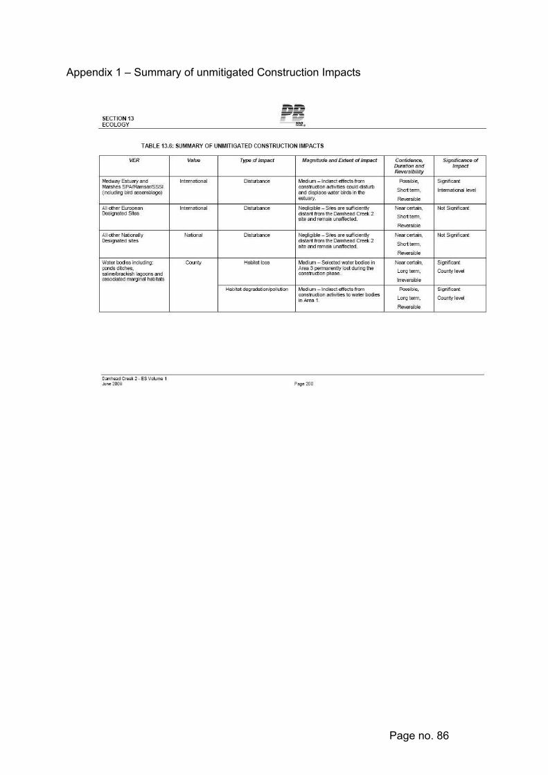
Page no. 86
Appendix 1 – Summary of unmitigated Construction Impacts

Page no. 87
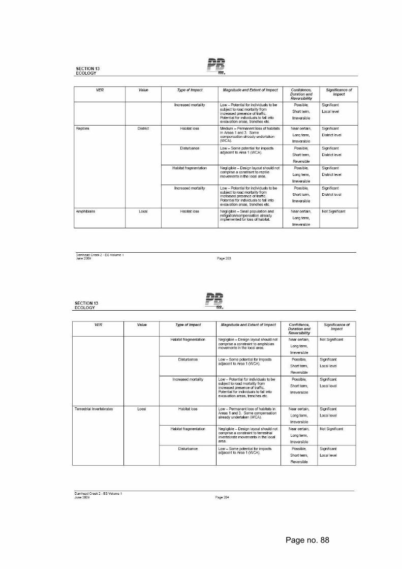
Page no. 88

Page no. 89
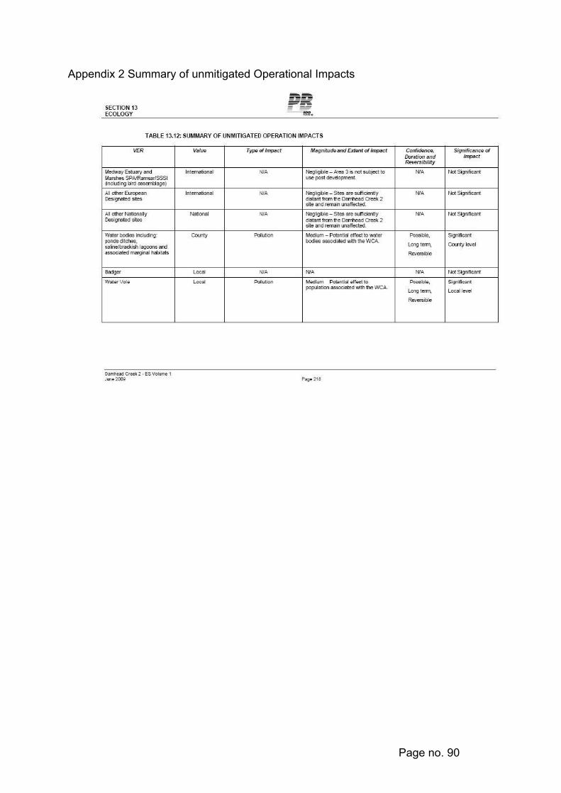
Page no. 90
Appendix 2 Summary of unmitigated Operational Impacts

Page no. 91

Page no. 92
Appendix 3 - Planning Policy Statement: Planning and Climate Change (December 2007) - The Key Planning Objectives and Decision Making Principles
Planning Policy Statement: Climate Change – Supplement to Planning Policy Statement 1 KEY PLANNING OBJECTIVES To deliver sustainable development, and in doing so a full and appropriate response on climate change, regional planning bodies and all planning authorities should prepare, and manage the delivery of, spatial strategies that: • make a full contribution to delivering the Government’s Climate Change
Programme and energy policies, and in doing so contribute to global sustainability;
• in providing for the homes, jobs, services and infrastructure needed by communities, and in renewing and shaping the places where they live and work, secure the highest viable resource and energy efficiency and reduction in emissions;
• deliver patterns of urban growth and sustainable rural developments that help secure the fullest possible use of sustainable transport for moving freight, public transport,
• cycling and walking; and, which overall, reduce the need to travel, especially by car;
• secure new development and shape places that minimise vulnerability, and provide resilience, to climate change; and in ways that are consistent with social cohesion and inclusion;
• conserve and enhance biodiversity, recognising that the distribution of habitats and species will be affected by climate change;
• reflect the development needs and interests of communities and enable them to contribute effectively to tackling climate change; and
• respond to the concerns of business and encourage competitiveness and technological innovation in mitigating and adapting to climate change.
DECISION-MAKING PRINCIPLES Regional planning bodies and all planning authorities should apply the following principles in making decisions about their spatial strategies: • the proposed provision for new development, its spatial distribution,
location and design should be planned to limit carbon dioxide emissions; • new development should be planned to make good use of opportunities
for decentralised and renewable or low carbon energy; • new development should be planned to minimise future vulnerability in a
changing climate; • climate change considerations should be integrated into all spatial
planning concerns;

Page no. 93
• mitigation and adaptation should not be considered independently of each other, and new development should be planned with both in mind;
• sustainability appraisal (incorporating strategic environmental assessment) should be applied to shape planning strategies and policies that support the Key Planning Objectives; and
• appropriate indicators should be selected for monitoring and reporting on in regional planning bodies’ and planning authorities’ annual monitoring reports. Such monitoring should be the basis on which regional planning bodies and planning authorities periodically review and roll forward their planning strategies.
Planning authorities should adhere to the following principles in determining planning applications:
• controls under the planning, building control and other regulatory regimes should complement and not duplicate each other;
• information sought from applicants should be proportionate to the scale of the
• proposed development, its likely impact on and vulnerability to climate change, and be consistent with that needed to demonstrate conformity with the development plan and this PPS;
• specific and standalone assessments of new development should not be required where the requisite information can be made available to the planning authority through the submitted Design and Access Statement, or forms part of any environmental impact assessment or other regulatory requirement; and
• in considering planning applications before Regional Spatial Strategies (RSS) and Development Plan Documents (DPD) can be updated to reflect this PPS, planning authorities should have regard to this PPS as a material consideration, which may supersede the policies in the development plan. Any refusal of planning permission on grounds of prematurely because a DPD is being prepared or is under review but has not yet been adopted should be consistent with Government policy.
_________________________________________________________________

Page no. 94
2 MC/09/1078
Date Received: 13 April, 2009
Location: Shell Garage 16-22 London Road Rainham Gillingham ME8 6YX
Proposal: Erection of a two storey building to include ground floor A1 to Hot food take away (A5) and 2 one bed flats at first floor level
Applicant: Boundwell
Agent: Mr McQueen Richard Unwin Chartered Surveyor 10 Green Fold Abbet Hey Manchester M18 8RJ
Ward Twydall
_________________________________________________________________ Recommendation of Officers to the Planning Committee, to be considered and determined by the Planning Committee at a meeting to be held on 6 January, 2010. Recommendation - Approval with Conditions (as amended by drawing received on 26 October 2009 and additional information received on 14 August and 19 October 2009) 1 The development hereby permitted shall be begun before the expiration of
three years from the date of this permission. Reason: To comply with Section 91 of the Town and Country Planning Act 1990 (as amended).
2 No development shall take place until there has been submitted to and approved in writing by the Local Planning Authority a plan indicating the positions, design, materials and type of boundary treatment to be erected. The boundary treatment shall be completed before any part of the building is occupied and shall thereafter be retained. Development shall be carried out in accordance with the approved details. Reason: To ensure that the appearance of the development is satisfactory and without prejudice to conditions of visual amenity in the locality, in accordance with Policy BNE1 of the Medway Local Plan 2003.

Page no. 95
3 No development shall take place until details and samples of all materials to be used externally have been submitted to and approved in writing by the Local Planning Authority, and the development shall be carried out in accordance with the approved details. Reason: To ensure that the appearance of the development is satisfactory and without prejudice to conditions of visual amenity in the locality, in accordance with Policy BNE1 of the Medway Local Plan 2003.
4 Notwithstanding the provisions of the Town and Country Planning (General Permitted Development) Order 1995 (or any order revoking and re-enacting that Order with or without modification) no windows or similar openings other than those on the approved plans shall be constructed in the east or west elevations of the building as hereby approved without the prior written approval of the Local Planning Authority Reason: To enable the Local Planning Authority to regulate and control any such further development in the interests of amenity and privacy of adjoining property, in accordance with Policy BNE2 of the Medway Local Plan 2003.
5 No development shall take place until there has been submitted to and approved by the Local Planning Authority a scheme of landscaping (hard and soft). All planting, seeding and turfing comprised in the approved scheme of landscaping shall be implemented during the first planting season following occupation of the buildings or completion of the development, whichever is the earlier. Any trees or plants which within 5 years of planting are removed or become seriously damaged or diseased shall be replaced in the next planting season with others of a similar size and species, unless the Authority gives written consent to any variation. Reason: Pursuant to condition 197 of the Town and Country Planning Act 1990 and to protect and enhance the appearance and character of the site and locality, in accordance with Policy BNE1 and BNE6 of the Medway Local Plan 2003.
6 The A1 (retail) use hereby permitted shall only operate between the hours of 07:00 to 22:00 Monday to Friday, 08:00 to 22:00 Saturday and 09:00 to 22:00 Sunday and Bank Holidays and the A5 (hot food takeway) use hereby permitted shall only operate between the hours of 09:00 to 23:00 Monday to Friday, 09:00 to 23:00 Saturday and 10:00 to 22:00 Sunday and Bank Holidays unless otherwise agreed in writing by the Local Planning Authority. Reason: To regulate and control the permitted development in the interests of amenity in accordance with Policy BNE2 of the Medway Local Plan 2003.
7 Prior to the commencement of the development hereby permitted, a scheme for protecting the proposed development from transport related noise that implements the measures described in the noise assessment reference 09/3090/R1 dated 12 October 2009 and includes acoustically screened mechanical ventilation to bedrooms, shall be submitted and approved in

Page no. 96
writing by the Local Planning Authority. All works, which form part of the approved scheme, shall be completed before any part of the development is occupied and shall thereafter be maintained in accordance with the approved details. Reason: In the interest of amenity in accordance with policies BNE2 and BNE3 of the Medway Local Plan 2003.
8 No goods shall be loaded, unloaded or stored within the application site outside the hours 07:00 to 19:00 Monday to Friday, 08:00 to 18:00 Saturday or at any time on Sunday or Bank Holidays. Reason: To regulate and control the permitted development in the interests of amenity in accordance with Policy BNE2 of the Medway Local Plan 2003.
9 Prior to the commencement of the development hereby permitted, a scheme of mitigation for noise from fixed plant that implements the measures described in the noise assessment reference 09/3090/R1 dated 12 October 2009 shall be submitted to and approved in writing by the Local Planning Authority. All works, which form part of the approved scheme, shall be completed before any part of the development is occupied and shall thereafter be maintained in accordance with the approved details. Reason: To regulate and control the permitted development in the interests of amenity in accordance with Policy BNE2 of the Medway Local Plan 2003.
10 The noise rating level (LA,T) associated with the development site, shall not exceed the background noise level (LA90,T), by more than 3dB. The noise levels shall be determined at the nearest noise sensitive receptors. All measurements shall be defined and derived in accordance with BS4142: 1997. Reason: To regulate and control the permitted development in the interests of amenity in accordance with Policies BNE2 and BNE3 of the Medway Local Plan 2003.
11 Prior to the commencement of the development hereby permitted, a scheme for the extraction and treatment of cooking fumes, including details for the control of noise and vibration from the system, shall be submitted to and approved in writing by the Local Planning Authority. The approved scheme shall be implemented before the development is brought into use and thereafter be maintained in accordance with the approved details. Reason: To regulate and control the permitted development in the interests of amenity in accordance with Policy BNE2 of the Medway Local Plan 2003.

Page no. 97
17 Prior to commencement of the development, details of cycle parking provision for the residential and commercial uses of the site shall be submitted to and approved in writing by the Local Planning Authority. The approved details shall be implemented prior to first occupation or first use of the development, whichever is the sooner. Reason: In the interests of the amenity of the future occupiers and users of the site in accordance with policy T4 of the Medway Local Plan 2003.
18 Prior to the first occupation of the development hereby permitted, vision splays of 2.0 metres x 2.0 metres shall be provided on both sides of the vehicular access points and no obstruction of sight more than 0.6 metres above carriageway level shall be permitted within the splays thereafter. Reason: To ensure that the development permitted does not prejudice conditions of highway safety or efficiency in accordance with Policy T1 of the Medway Local Plan 2003.
19 Prior to commencement of the development, details of measures to control use of the vehicle access points shall be submitted to the Local Planning Authority for written approval. The details will show how vehicles shall only access the site via the western access and only egress from the eastern access point. The approved details shall be implemented as approved prior to the first occupation or use of the development, whichever is the first and shall thereafter be maintained. Reason: To ensure that the development permitted does not prejudice conditions of highway safety or efficiency in accordance with Policy T1 of the Medway Local Plan 2003.
20 Unless otherwise agreed by the Local Planning Authority, development other than that required to be carried out, as part of an approved scheme of remediation must not commence until conditions 21 to 23 have been complied with. If unexpected contamination is found after development has begun, development must be halted on that part of the site affected by the unexpected contamination to the extent specified in writing by the Local Planning Authority until condition 23 has been complied with in relation to that contamination Reason: To ensure that the development permitted does not prejudice conditions of safety in accordance with Policy BNE23 of the Medway Local Plan 2003.
21 A detailed remediation scheme to bring the site to a condition suitable for the intended use by removing unacceptable risks to human health, buildings and other property and the natural and historical environment must be prepared, and submitted to and approved in writing by the Local Planning Authority prior to commencement of the development. The scheme must include all works to be undertaken, proposed remediation objectives and remediation criteria, timetable of works and site
Page no. 98
management procedures. The scheme must ensure that the site will not qualify as contaminated land under Part 2A of the Environmental Protection Act 1990 in relation to the intended use of the land after remediation. Reason: To ensure that the development permitted does not prejudice conditions of safety in accordance with Policy BNE23 of the Medway Local Plan 2003.
22 The approved remediation scheme must be carried out in accordance with its terms prior to the commencement of any development (other than development required to enable the remediation process to be implemented) unless otherwise agreed in writing by the Local Planning Authority. The Local Planning Authority must be given not less than two weeks written notification prior to the commencement of the remediation scheme works. Following completion of the measures identified in the approved remediation scheme, a verification report (referred to in PPS23 as a validation report) that demonstrates the effectiveness of the remediation carried out must be produced, and submitted to and approved in writing by the Local Planning Authority prior to the bringing into use of the development. Reason: To ensure that the development permitted does not prejudice conditions of safety in accordance with Policy BNE23 of the Medway Local Plan 2003.
23 In the event that contamination is found at any time when carrying out the approved development that was not previously identified it must be reported in writing immediately to the Local Planning Authority. An investigation and risk assessment must be undertaken and where remediation is necessary a remediation scheme must be prepared in accordance with the requirements of condition 21, which is subject to the approval in writing of the Local Planning Authority. Following completion of the measures identified in the approved remediation scheme a verification report providing details of the data that will be collected in order to demonstrate that the works set out in condition 21 are complete and identifying any requirements for longer-term monitoring of pollutant linkages, maintenance and arrangements for contingency action must be prepared, which is subject to the approval in writing of the Local Planning Authority in accordance with condition 22. Reason: To ensure that the development permitted does not prejudice conditions of safety in accordance with Policy BNE23 of the Medway Local Plan 2003.

Page no. 99
24 Piling or any other foundation designs using penetrative methods shall not be permitted other than those with the express written consent of the Local Planning Authority, which may be given for those parts of the site where it has been demonstrated that there is not resultants unacceptable risk to groundwater. Reason: The site overlies an aquifer used for public water supply in accordance with Policy CF12 of the Medway Local Plan 2003.
25 No infiltration or surface water drainage into the ground is permitted other than with the express written consent of the Local Planning Authority, which may be given for those parts of the site where it has been demonstrated that there is no resultant unacceptable risk to controlled waters. Reason: To prevent pollution of controlled waters in accordance with Policy CF12 of the Medway Local Plan 2003.
26 Prior to the commencement of the development details of a scheme of external lighting for the site and building shall be submitted to and approved in writing by the Local Planning Authority. The approved scheme shall be implemented prior to first occupation and thereafter be maintained. Reason: in the interests of safety of users and staff at premises.
27 No development shall take place until the developer has secured the implementation of a watching brief to be undertaken by an archaeologist approved by the Local Planning Authority so that the excavation is observed and items of interest and finds are recorded. The watching brief shall be in accordance with a written programme and specification, which has been submitted to and approved in writing by the Authority. Reason: To safeguard the archaeological interest in the site in accordance with Policy BNE21 of the Medway Local Plan 2003.
For the reasons for this recommendation for approval please see planning appraisal section and conclusions at the end of this report. Site Description The application relates to the curtilage of a vacant petrol station. To the east is an office with several flank wall windows at first and ground floor, to the west is an osteopath on the ground floor with obscure glazed flank wall windows that relate to treatment rooms and on the first floor a residential property with habitable room flank wall windows. To the north is a tyre fitters and to the south across the A2 residential premises and office use.

Page no. 100
Proposal The application concerns the demolition of the present structures and the construction of a part single part two-storey building for use on the ground floor as A5 (Take away) and A1 (retail) and the first floor as two one-bed flats each with a bedroom, bathroom and kitchen/living room. The building is proposed to the south side of the plot approx. 7m from the front boundary. The ground floor of the building is approx. 15.3 in width, 14.2m in depth and the single storey portion is 4m in height with a flat roof. The first floor is approx. 7m long, 15.3m wide and 8.1m in height with a pitch roof. The external walls are proposed to be finished in a rendered panel wall with expressed panel joints. The roof is proposed to be formed from a metal standing seam roof with parapet walls. Shutters are proposed to the two end windows at first floor with canopies over the remaining windows. The ground floor is proposed for use as an A5 take away and A1 retail and the development is shown as being split into two units of equal size. Twelve parking spaces are proposed to the rear of the site with two being used for disabled parking. Cycle parking is proposed to the front of the site and in the north west corner. The existing “one way” access and egress from the site is proposed to be retained in the same position. Servicing of the units is provided by a delivery bay to the rear of the site, which also doubles as two parking spaces when not in use. To the north west corner of the site is an area dedicated for bins. This differs from the refused application through the change in the first floor from storage/staff room to two one-bed flats and through a change in the design. Representations The application has been advertised by means of a site notice. Neighbour notification letters have been sent to the owners and occupiers of: 1, 2, 2a, 4, 18, 31, 32, 36, 45 Edwin Road, 5, 12, 12a, 14, 24, 24a, 26, 26a, 28, 275, 277, 279, 281, 285, 287, The Hop and Vine P.H, Watling Tyres, Jade Business Bureau London Road and 1, 10, 11, 12, 13, 14, 17 Elizabeth Court, 10 Green Fold 65 Marshall Road and MP Paul Clark. The Environment Agency, Southern Water Services and the Kent Police Architectural Liaison officer have been consulted on the application. 72 letters have been received from 50 households raising the following concerns:
• Only minor changes to the refused scheme, therefore all objections made at that time are still relevant
• Only 12 spaces therefore if there are more than 12 cars they will queue onto London Road or at the bottom of Edwin Road. The proximity of the pedestrian crossing which is less than 20m from where the cars will exit the site will pose an additional risk to pedestrians
Page no. 101
• Customers parking at the bottom of Edwin Road will increase the volume of traffic, congestion and traffic jams especially at peak times
• Cars will turn into the site from Edwin Road and will not abide by the road markings. When the petrol station was in use cars used it as a roundabout to enable them to turn right in the direction of Rainham without going round the roundabout
• Traffic has increased since the last application was refused in 2007 and will not decrease in the future when the Tesco superstore is enlarged. If permission is granted now it would overturn the previous objections that were upheld by the planning committee
• Increase in accidents due to queuing cars • Surprised that the Council are entertaining this proposal again • There are other fast food outlets in the area, another would lead to increased
anti social behaviour and cause unnecessary worry and problems for the neighbouring Elderly Housing residents
• There would be indiscriminate parking on the main A2 • Hazard for the cycle lane on the footway • Delivery vehicles will cause even more congestion on a very dangerous part
of the A2 • Narrow filter lane turning right into Edwin Road, if there is to be another filter
lane into this site this will increase the chances for more accidents at an already hazardous junction
• Question over the opening hours and delivery times which will create noise and disturbance
• Additional noise, light pollution, rubbish, odour • Exacerbate the drug problem in the area • Query over why the site cannot be used for residential properties - it should
be redesignated • Reduce the quality of life for residents • Significant improvements in road traffic accidents since the closure of the
petrol station and it is likely this will rise again • Concern over the number of times this application has been in to the Council • Unnecessary due to the number of other take aways • Existing parking problems at the top of Hawthorne Avenue leading onto
Caldew Avenue • Accident blackspot • Site notice was removed • Concern for welfare and safety with the remediation needed for the site • Concern about consultation procedures • Tesco expansion and Howard School development will add to the traffic
problems on the A2 • Area is better since closure of the petrol station • Breaking some Human Rights • Concern that some letters of support are not written by people that live in the
area • Does not fit into the community and would cause considerable levels of stress
to vulnerable members of the community • There are other Domino branches in the area, these could be used to serve

Page no. 102
the community • Concern that they were not notified - Potential post problem because letters
were sent to those concerned Councillor Griffiths has written to express concern with regard to:
• A5 facility not appropriate in this area, runs counter to the approach being adopted by the Council in concentrating such uses in clearly defined areas
• Councils current approach for this site is flawed – fails to reflect the major changes that have been made on the Tesco site
• Development of Tesco site will exacerbate the already exponential increase in traffic movements in the area
• Identification of the former service station as a secondary employment area could be reconsidered
• Council should reconsider the acceptability of a solely housing use for the site and then encourage such a development. With a possible solution being a private development extension of the Council-owned Elizabeth Court.
Councillor Hewett has written to express concern with regard to: • Additional traffic problems resulting in the site being opposite Edwin Road and
traffic will attempt to cross the busy main A2 road in both directions • Safety concerns that result from cross traffic movement, which was well
documented when the site was used as a petrol station, particular concern for users of the cycle path to the front of the site
• Danger to school children in the area Environment Agency advise no objection subject to the imposition of their proposed conditions that relate to contamination, remediation, foundations, surface water drainage Southern Water has written to advise that they can provide foul and surface water sewage disposal to service the proposed development. Kent Police Architectural Liaison Officer has written to advise of the following concerns with regard to: • The rear parking area which may become a point for congregation or antisocial
behaviour or wrongdoing. Out of hours this could cause an adverse affect on neighbouring residential amenity either existing or proposed. This area is out of view and its existence could therefore allow persons to congregate here undetected, which could in part potentially increase vulnerability of the 2 commercial outlets to crime and vehicles.
• Bin stores are positioned close to rear build line. These could be used as climbing aids to access the rear flat roof and in turn roof lights on this or rear windows of the two flats over. It is suggested that these are moved away from build lines or any adjacent boundary fencing that could result in them being used to access other adjacent private areas and the bins be situated in secure lockable compounds to stop them being relocated or tampered with.

Page no. 103
• Robust and efficient lighting scheme would be necessary to ensure the vehicular access routes, parking area, frontage were all well lit
• The knee rail fence to front boundary could become a seating point and it is suggested that a design be utilized that will not easily encourage or facilitate seating. Additionally shrub planting here should be of a type that can be maintained below a height of 1m to ensure natural surveillance
• Potential concerns from a highway safety viewpoint, due in part to the close proximity of the pedestrian crossing, adjacent residential roads linking off London Road and how measures could be introduced to reduce likelihood of potential accidents or inappropriate manoeuvring into or out of the site
• On the information available unable to determine how substantial mitigating measures have been put in place over the previously declined application of a similar nature that would result in a change of planning committee or officer decision
Paul Clark MP has written to express concern with regard to:
• Proliferation of fast food outlets - there are already a number of fast food outlets in the area and numerous cafes and restaurants a number of these also provide a take away service so there is no need for a take away nearer and unnecessary particularly as the area proposed for the site is predominantly residential
• Traffic and pedestrian safety - The proposed plans would result in a significant increase in traffic in the area which already suffers from heavy congestion and is likely to suffer from more with the expansion of Tesco's Superstore and the development of the football facility on the Howard School site. The heavy traffic would be extremely difficult to manage if the M2 was closed for any reason and the traffic was diverted onto the A2. Additional cars and indiscriminate parking that would result from them would be extremely hazardous for pedestrians, increasing the potential of accidents. This would be especially the case at the pedestrian crossing which is situated in close proximity to the site. The traffic would also greatly increase the risk of serious collision between vehicles travelling along the A2 and vehicles crossing the A2 into Edwin Road or turning right from the site and heading in the direction of Chatham. With only 12 spaces allocated on the proposed site, cars queuing on the London Road or at the bottom of Edwin Road would be inevitable. There is a cycle lane running along the path which world become extremely dangerous to use with vehicles driving in and out of the proposed site. Concern that cars would exit Edwin Road and use the site to enable them to turn right which occurred when the petrol station was in use. Arriva bus company now runs double-decker buses up and down Edwin Road. When these busses are turning right into Edwin Road they completely block the east bound A2 due to their width and length. This is already a problem and will only be exacerbated by vehicles turning in and out of the site.
• Environmental Concerns - Rubbish would be generated in the area. Additional noise and light pollution. Air quality issues resulting from additional traffic.
Page no. 104
141 letters of support have been received from 130 Households and 2 petitions with a total of 36 signatures Development Plan Policies South East Plan 2009
Policy SP3 (Urban focus and urban renaissance) Policy T4 (Parking) Policy CC1 (Sustainable Development) Policy BE1 (Management for an Urban Renaissance)
Medway Local Plan 2003
Policy BNE1 (Built Environment) Policy BNE2 (Amenity Considerations) Policy BNE3 (Noise Considerations) Policy BNE23 (Contaminated Land) Policy BNE43 (Trees and development sites) Policy T1 (Impact of Development) Policy T3 (Provision for Pedestrians) Policy T4 (Cycle Facilities) Policy T13 (Vehicle Parking Standards) Policy R10 (Local centers, village shops and neighbourhood centers) Policy R18 (Take away hot food shops, restaurants, cafes, bars and
public houses) Planning History GL/61/229/90/0233 Proposed redevelopment to include new sales building, petrol
pumps and canopy. Approved 29 June 1990 MC2000/0935 Display of various internally illuminated and non-illuminated
signs Approved 25 July 2000 MC2001/1443 Application for prior approval under Part 24 of the Town and
Country Planning (General Permitted Development) Order 1995 for the siting of a 15m high telecommunications street tower with one tri-sector antenna and ancillary equipment cabin
Withdrawn MC2005/0252 Demolition of buildings and construction of building for use as
car wash facility with ancillary office Refused 21 November 2005 MC2007/0462 Construction of single storey building for use as two units, unit A
Class A1 and unit B Class A5 (demolition of buildings) Refused 14 May 2007

Page no. 105
MC2007/1207 Construction of a part single, part two storey building for use as
ground floor A5 (Hot Food Takeaways) and first floor storage/staff room (demolition of buildings)
Refused 20 September 2007 Planning Appraisal Principal The site lies within the urban area and in a recognised neighbourhood centre in the adopted Local Plan and the principle of commercial development including A5 Take away uses is unobjectionable in development plan and national planning policy guidance terms subject to design, neighbourhood amenity and highways issues being satisfied. Street Scene and Design The proposed building located to the front of the site with commercial use on the ground floor and flats above at first floor fits in well with the prevailing character of the area, which comprises properties that are set to the front of their plots. The vacant site is incongruous and detrimental to the street scene in its existing condition and consequently lends itself to being enhanced. It is considered that a two storey development, set closer to the front of the site would be a better use of the site and would be more in keeping with the frontage of adjoining properties and hence more in character with the street scene than the current set up and is regarded as acceptable. While the large expanse of the flat roof portion of the single storey element is not aesthetically pleasing it is hidden from most angles of view by the surrounding buildings and is of a functional design that is not considered so objectionable to refuse the scheme. The agents have supplied information with regard to the potential users of the ground floor takeaway. Dominos Pizza are the proposed occupier for of the A5, their supporting statement advises that Dominos pizzas are only prepared and baked on receipt of an order, and that pizzas are not kept warm waiting sales like many other A5 users. Dominos advise that the vast majority of orders are received on the telephone, with only about 20% bought by visiting members of the public. These figures are supported by local experience at more than 550 stores in the UK. The parking set to the rear of the site is functional and yet hidden from sight. The raised planting beds to the front of the site will enable soft landscaping to enhance the street scene and soften the building and otherwise hard street scape. The proposed design is very different to that of the refused scheme and offers a more modern appearance. While this new building would stand out in the street scene as being of a different build to those adjacent buildings it is an innovative design and one that would fit in with the mixed area and offer a new sleek building in the street.
Page no. 106
As such the proposed development is considered to be in acceptable within the prevailing street scene. The proposal is in accordance with Policy BNE1 of the Medway Local Plan. Neighbour Amenities While the new building would be approximately double the size of the present petrol filling station building and two stories in height, the existing canopy over the fore court would be demolished. Due to the siting of the building with regard to the neighbours habitable room windows and the design of the building, which reduces to single storey to the rear, the development is considered to be unlikely to have any material impact upon the prevailing conditions of light, outlook or privacy for neighbouring properties other than by way of possible improvement. Noise from operation of commercial units and deliveries The primary form of control of noise generated within the premises will be by way of hours of operation. In order to safeguard the situation a condition is recommended on any forthcoming consent to be subject to the following hours of use: - Retail use (Class A1) 07:00 to 22:00 Monday to Friday 08:00 to 22:00 Saturday 09:00 to 22:00 Sunday Take away use (Class A5) 09:00 to 23:00 Monday to Friday 09:00 to 23:00 Saturday 10:00 to 22:00 Sunday The acoustic appraisal demonstrates that the site is within noise exposure category (NEC) C during the day and night. The Medway Local Plan Adopted Version 2003 includes a policy on noise, Policy BNE3. The Policy states that where noise levels fall within category C, the development will not be permitted unless either (a) the site is allocated for residential development or (b) there are no alternative quieter sites available. The applicant has demonstrated that with thermal double glazing, reasonable internal noise levels as defined by British Standard 8233: Sound insulation and noise reduction for buildings – Code of Practice, will be achieved in living rooms and bedrooms with windows closed. Levels will also be commensurate with the World Health Organisation Guidelines (WHO) for Community Noise. However, with windows open for rapid ventilation and summer cooling acceptable noise levels within these rooms will not be achieved.
Page no. 107
The assessment suggests that, as the living rooms are through rooms that the rear window can be used for ventilation. This is acceptable. However, the assessment recommends that acoustic trickle vents are used in bedrooms. This is not acceptable, acoustically screened mechanical ventilation should be installed in both bedrooms, this can be controlled through the proposed. The acoustic assessment has also considered noise from fixed plant within the application site. It has proposed noise limits based on the background noise levels in the area and has identified that mitigation is required for the cold-room condenser and for the kitchen extract fan of the takeaway commercial unit a suitably worded condition is recommended to control this. Odour The previous application was refused on account of it being prejudicial to the amenities of the locality by virtue of additional noise and disturbance, smells and inconvenience to local residents. The drawings and design and access statement show that a ventilation system will be installed. The applicant has provided a standard specification for a ventilation system and air conditioning system. This gives general information on how cooking odours will be removed within the ventilation system. The details are satisfactory in terms of the height of the termination of the flue and that the system will include grease filters and carbon filters. However, it is recommended that a suitably worded condition is added to any permission to ensure that the final system is acceptable. Contaminated Land The contamination assessment which has been submitted which recommends that remediation is undertaken. Appropriate conditions are recommended. In addition the Environment Agency recommend additional conditions to protect ground water and these are set out in the recommendation. As such the proposed development is considered in accordance with policy BNE23 of the Medway Local Plan 2003. Traffic generation The proposed flats are likely to generate 4 vehicle movements per day, with up to 1 vehicle movement in each peak period. An A1 retail unit of 100sqm is predicted to generate 15 vehicle trips during the AM peak and 20 trips during the evening peak with a total of 211 vehicle movements throughout the day. It is estimated that significantly more trips, around 550 throughout the day, would be made on foot. This assumes a convenience store type use, which represents a 'worst case scenario' in terms of traffic generation. The TRICS database indicates that a hot food takeaway use would generate 18 vehicle trips during the evening peak hour, with a total of 155 vehicle trips over a 14-hour period (an average of 11 trips per hour). An estimated total of 114 trips would made on foot. One of the sites surveyed was a Dominoes Pizza outlet in a suburban area. This generated, on average, 10 vehicle trips during the evening peak hour and a total of 47 vehicle trips over a 7-hour period (approximately 7 vehicle trips per hour, on average). The lower number of trips

Page no. 108
generated by a Dominoes Pizza outlet is most likely explained by a high number of home deliveries: the supporting document submitted with the application indicates that 80% of orders are delivered to customers rather than collected from the premises. Therefore, a total of 370 vehicle trips per day could be generated by the proposed development, with 16 vehicle trips during the morning peak hour and 39 vehicle trips during the evening peak. As outlined above, the number of vehicle trips could be reduced should a Dominoes Pizza outlet occupy the unit, due to a greater emphasis on home deliveries. The site was previously used as a petrol filling station. The TRICS database indicates that, based on the provision of 6 filling bays, the petrol station would have generated in the region of 68 vehicle trips during the morning peak and 79 trips during the evening peak. A total of 1,155 vehicle trips are likely to have occurred over a 16-hour period, which equates to an average of 72 vehicle movements per hour. The proposed use will therefore generate significantly fewer vehicle movements during the peak periods, and throughout the day, than the previous use. Whilst the petrol station closed some time ago, the site has not been cleared and structures remain. On this basis, it is reasonable to regard the former use as a material consideration and make comparisons with the traffic generated by the current proposal as it represents the fall-back position. Pedestrian and vehicular access There are a number of junctions and existing private access points along the northern side of the A2 in the vicinity of the site that generate turning movements on to the main road. However, the accident database indicates that only one accident within 200 metres of the site has resulted from a turning movement onto a private access in the past three years. The accident rate on this section of the A2 is generally low, with one accident recorded at the Edwin Road junction and two accidents at the Marshall Road junction, all “slight” in severity. Whilst there is a 40mph speed limit in the immediate vicinity of the site, speed surveys undertaken by the Council in 2008 indicate an 85th percentile traffic speeds of between 33 and 34mph in each direction. The wide footway along the site frontage will ensure that vehicles leaving the site have a clear line of sight along the A2 for some distance, as was the case when the site operated as a petrol filling station. Existing markings in the centre of the carriageway provide a right-turn filter into the site's western access, and therefore it is recommended that vehicles continue to access the site via the western access point, with vehicle egress taking place from the eastern access. This could be secured by condition. As outlined above, the A1 use in particular is likely to generate a significant volume of pedestrian movements. A pelican crossing is situated in close proximity to the site, which will provide customers from the south with a safe and convenient means of crossing the A2. A central footway has been added to the scheme to ensure pedestrian safety and remove potential conflict with pedestrians accessing the site, therefore no objection is raised and the proposal is considered to be in accordance with policy T1 of the Medway Local Plan 2003.

Page no. 109
Parking Local Plan Policy T13 recommends that up to a maximum of 14 car parking spaces is appropriate to serve the needs of the development. A total of 12 car parking spaces are provided, and therefore the proposal accords with this policy. The site is easily accessible by non-car modes: good pedestrian facilities links the site with the surrounding residential area, a cycle route runs along the site frontage and bus services operate along the A2 every 10 minutes. In addition, the presence of suitable restrictions in the vicinity of the site reduces the likelihood of indiscriminate parking that would compromise highway safety and the free-flow of traffic. Some provision for cycle parking is indicated on the plan, however it is appropriate for further details to be secured by condition. On this basis, it is considered that the proposed level of car parking achieves an appropriate balance between serving the needs of the development yet encouraging travel by sustainable modes, and therefore no objection is raised and the proposal is considered to be in accordance with policy T13 of the Medway Local Plan 2003. Trees There are no trees of any significance on the application site. There are several overgrown shrubs within the vicinity of the existing garage. There are 3 mature Sycamore situated on the rear boundary of 24 London Road. These trees are situated between 2 and 4 metres from the boundary of the development site. These trees are of low amenity value as they have been badly pruned in the past and are probably self-seeded. In view of the fact that these trees are of low amenity value and the proposed works appear to be taking place outside of the root protection area, no objection is raised. As such the proposed development is considered to be in accordance with Policy BNE43 of the Medway Local Plan 2003. Conclusions and Reasons for approval The proposed development will not be out of context with its surroundings and it is considered to be acceptable for the reasons outlined above. It is therefore recommended that the proposal be approved subject to the imposition of appropriate conditions. The proposal therefore accords with the provisions of Policies SP3, T4, CC1 and BE1 of the South East Plan and Policies BNE1, BNE2, BNE3, BNE23, BNE43, T13, R10 and R18 of the Local Plan and the application is accordingly recommended for approval. The application would normally fall to be determined under delegated powers but has been referred to Committee due to the number of representations received contrary to officer’s recommendation. _________________________________________________________________

Page no. 110
3 MC/09/2471
Date Received: 26 November, 2009
Location: HOLY TRINITY CHURCH, TWYDALL LANE, TWYDALL, GILLINGHAM, ME8 6JU
Proposal: Listed building application for the demolition of existing church and church hall buildings
Applicant: Mr Cryer
Agent: Mr Cadoret S + P Architects Floor 8 Victory House 30-34 Kingsway London WC2B 6EX
Ward Twydall
_________________________________________________________________ Recommendation of Officers to the Planning Committee, to be considered and determined by the Planning Committee at a meeting to be held on 6 January, 2010. Recommendation - Refusal 1 The development involves the demolition of the Holy Trinity Church, which is
a Grade II listed building. Insufficient evidence has been provided to justify the loss of the building, which would ultimately harm the character, and appearance of the vicinity and result in the loss of the historical value of the Church contrary to PPG15, Policy BE6 of the South East Plan 2009 and Policy BNE16 of the Medway Local Plan 2003.
Site Description The application site is located within the urban boundary of Gillingham to the south of the Twydall Local Centre. Twydall Lane consists of a mixed street scene with residential properties of differing design, style and age. In general terms the development to the north, east and west of the site is post war development that is dominated by 2-storey residential dwellings and blocks of flats. Immediately to the north of the site is Twydall Local Centre, which is an inward, looking retail area that is designed to face a communal central car park. Retail units arranged in 2-storey buildings dominate the Local Centre. Immediately to the south is the Nye Bevan Memorial Hall and to the east are a medical centre and the vicarage. The application site currently consists of the Holy Trinity Church along with its associated church hall, car park and grounds. The church occupies a prominent

Page no. 111
position on the corner of Twydall Lane and Waltham Road and is a building of individual design dating from the 1960s. The church is set back from the corner and grassed areas are located between it and the pavement edges along with railings measuring approximately 1.5 metres in height. The pedestrian access to the Church is from Twydall Lane. To the south of the church is the associated church hall, which is a single storey detached building. Vehicular access to the site is also from Twydall Lane and leads to a parking area within the southern portion of the site. The Nye Bevan Hall to the south is located at a slightly higher level than the application site and as such there is a retaining wall on the southern boundary. The Church has been recently listed as being Grade II. Proposal The application is for listed building consent for the demolition of the existing church and church hall buildings Relevant Planning History MC2000/1950 Outline application for part demolition of church extension,
provision of car parking area for hall and construction of eight 3-bedroom houses with associated parking Refusal, 30 May 2001
MC2009/1152 Advertisement consent for installation of a non-illuminated free-
standing notice board Approved with Conditions, 8 October 2009
MC2009/1151 Demolition of existing buildings to provide a combined church
and community building together with construction of 23 dwellings comprising of nine 2-bedroomed apartments and fourteen 2 and 3-bedroomed houses together with associated hard and soft landscaping and new access road
Refused 16 December 2009 Representations The application has been advertised on site and in the press and neighbour notification letters have been sent to the owners / occupiers of 20 and 72 Staplehurst Road; 2, 4 and 4a Waltham Road, 1, 2, 3, 4-5, 4-6, 50, 51, 66 and 67 Twydall Green; 86, 122, 125, 135, 137, 139, 139a and Nye Bevan Memorial Hall Twydall Lane; 34 Northbourne Road; 1 Bishopsbourne Gardens; St Nicholas Church, Boley Hill, Rochester; 39 Canterbury Street; 16 Abbey Road; 6 Broadfield Road, Loose; 37 Hanway; 76 Thornham Road; 311 Beechings Way; 75 Lyndhurst Avenue; 109 Edwin Road; 24 Waltham Road; 4 Priory Road; 16 Goudhurst Road; 146 Woodlands Road and 1 Waterhouse Square, 138-142 Holborn, London. 14 letters of support expressing the following points: -
• Existing building is no longer sustainable • High costs involved in the up-keep of the building
Page no. 112
• Investigations into grant funding and other avenues have been unproductive • A replacement building which is multi purpose would be of greater benefit to the
people of Twydall • Proposal would result in much needed flats and houses on site as well as
landscaping benefits • Needed investment in Twydall • If refused building would be left empty • Need new community facilities 2 letters of objection have been received expressing concern regarding the proposal to demolish a unique and iconic building which would be a loss to Twdall. Kent Police Architectural Liaison Officer – Has commented on the enabling development from a crime prevention perspective and makes the following comments: - • Low parking ratio may lead to confrontational parking • Parking vehicles away from the owners dwelling could make them vulnerable to
crime • Use of rear doors as primary access (due to the parking layout) would reduce the
active frontage onto Twydall Lane • Secured by Design encourages parking close to host dwelling and doubts raised
whether this can be achieved with proposed layout. • Boundary treatments should be examined closely • Robust and efficient lighting scheme is needed • Blank gable walls should be avoided as they can be subject to graffiti • Defensible planting recommended around the Church • Design of church should restrict easy access to rooflines, as these can become
the target for theft. • Use of laminated glass and a central station monitored alarm are recommended. National Planning Guidance PPG15 (Historical Environment) Development Plan Policies South East Plan 2009 Policy BE6 (Management of the Historic Environment) Medway Local Plan 2003 Policy BNE16 (Demolition of Listed Buildings) Planning Appraisal The determining issue in relation to this application is:
Page no. 113
• Impact on the Listed Building Impact on the Listed Building, Street Scene and Design The church is a landmark building in the Lower Twydall area. The approach towards the church (through the Lower Twydall shopping precinct), presents the viewer with an impressive steeply pitched roof of Cedar shingles nestled in an attractive open space (the land associated with the church). The church forms an attractive and distinctive focal point between the surrounding housing and the central shopping area. The church was designed and built in 1964 by architect Arthur Bailey. The architect designed the interior furniture, with the exception of the organ. The altar and font are bespoke cast in-situ objects. This is unusual and demonstrates the care and consideration given to the overall design. It is unusual for modern buildings to be listed. The recent Grade II listing of this building is therefore a testament to its special architectural qualities. The primary purpose of listed building legislation is to protect special buildings from demolition. It follows from this that demolition should only be considered in specific circumstances. The tests of whether the demolition of a listed building is justifiable are laid down in the Government’s Planning Policy Guidance Note 15 (PPG15) and are as follows: PPG 15, paragraph 3.19i: the condition of the building, the cost of repairing it in relation to its importance and the value derived from its continued use… Paragraph 3.19i requires an assessment of the building and further states that ‘Any assessment should take into account of the possibility of tax allowances and exemptions and of grants and charitable sources.” The Design and Access Statement submitted as part of the listed building application indicates that repair costs are in excess of £800,000. However, this is not supported by any documents detailing specific costs for repair or the origin of this figure. Although supporting documents make reference to the difficulty of obtaining a grant (stating that it would be unlikely that a grant of more than £200,000 would be available from grant bodies) this statement is not supported with any evidence. The applicants have not provided evidence of an exhaustive search being undertaken in order to secure grants or funding from charitable sources. PPG 15, paragraph 3.19 ii: the adequacy of efforts to made to retain the buildings in
use: The paragraph states that ‘the (planning) authority should be satisfied that real efforts have been made without success to continue the present use or to find compatible alternative uses for the building.” The efforts should “include the offer of the unrestricted freehold of the building on the open market at a realistic price reflecting the buildings’’ condition.”

Page no. 114
The Design and Access Statement refers to an alternative scheme in partnership with the Health Authority. However, it provides no evidence as to why this scheme did not work and does not indicate whether any other options have been investigated (for example- sale to faith group) No marketing report has been provided as a part of the application and it does not appear that the building has been offered for sale. PPG 15, paragraph 3.19 iii, the merits of alternative proposals for the site:
The paragraph states “…There may very exceptionally be cases where the proposed works would bring substantial benefits to the community which have to be weighed against the arguments in favour of preservation. Even here, it will often be feasible to incorporate listed buildings within new development, and this option should be carefully considered…” The application does not indicate that the option of incorporating the church within a new development has been explored (for example new housing- the profits of which could pay for the restoration of the church) In addition to PPG15 policy BNE16 of the Medway Local Plan states ‘the demolition of Listed Buildings will not be permitted unless it can be demonstrated that there are exceptional and overriding reasons for demolition, and that all possible methods of preserving the building have been investigated.’ As outlined above the applicant has explained in supporting documentation that the existing church is in need of repair and difficult to maintain however there is insufficient evidence to support this argument and whilst the community and social benefits of a new facility are noted the integrity of the Listed Building is paramount and its loss is considered contrary to policy. Conclusions and Reasons for Refusal In summary the application for demolition of the Holy Trinity Church provides insufficient evidence on compliance with the tests laid out in PPG15 for the justification of the demolition of a listed building. Accordingly the proposal is considered unacceptable and contrary to the provisions of PPG15, policy BE6 of the South East Plan and policy BNE16 of the Medway Local Plan 2003. This application would normally fall to be determined under officers’ delegated powers, but is being reported for Members’ consideration due to the number of letters of representation received contrary to the officers recommendation. _________________________________________________________________

Page no. 115
4 MC/09/1397
Date Received: 9 September, 2009
Location: 47 Wainscott Road Wainscott Rochester ME2 4LA
Proposal: Construction of single storey rear extension and change of use from shop (Class A1) to hot food takeaway (Class A5) and parking area to rear
Applicant: Mr T Fuongly
Agent: Mr J Liddiard 14 Wentworth Drive Cliffe Woods Rochester Kent ME3 8UL
Ward Strood Rural
_________________________________________________________________ Recommendation of Officers to the Planning Committee, to be considered and determined by the Planning Committee at a meeting to be held on 6 January, 2010. Recommendation - Approval with Conditions 1 The development hereby permitted shall be begun before the expiration of
three years from the date of this permission. Reason: To comply with Section 91 of the Town and Country Planning Act 1990 (as amended).
2 All materials used externally shall match those of the existing building. Reason: To ensure that the appearance of the development is satisfactory and without prejudice to conditions of visual amenity in the locality, in accordance with Policy BNE1 of the Medway Local Plan 2003.
3 The hot food takeaway (Class A5) hereby permitted shall only operate between the hours of 08:00 to 22:00 Mondays to Fridays inclusive and between the hours of 08:00 to 23:00 on Saturdays and 12:00 to 2200 on Sundays and Public Holidays. Reason: To regulate and control the permitted development in the interests of aural amenity in accordance with Policy BNE2 and BNE3 of the Medway Local Plan 2003.
Page no. 116
4 Prior to the commencement of development, full details of the materials including surfacing and drainage to be used for the area shown on the submitted layout as 'shared access' and 'car park' shall be submitted to and approved in writing by the Local Planning Authority and the use shall not commencement until the approved details have been provided, on site. Thereafter those area shall be kept available for such use and no obstruction or permanent development, whether or not permitted by the Town and Country Planning (General Permitted Development) Order 1995 (or any order amending, revoking or re-enacting that Order) shall be carried out on that area of land or in such a position as to preclude the vehicular access or parking. Reason: Development without provision of adequate accommodation for the parking, loading, off-loading and turning of vehicles is likely to lead to hazardous conditions in the public highway and in accordance with Policy T1 of the Medway Local Plan.
5 No development shall take place until there has been submitted to and approved in writing by the Local Planning Authority a plan indicating the positions, design, materials, opening and type of boundary treatment to be erected on site. The boundary treatment shall be completed as approved before the use hereby permitted is commenced and shall thereafter be retained. Reason: To ensure that the development is undertaken which is not likely to lead to hazardous conditions in the public highway and private access and in accordance with Policy T1 of the Medway Local Plan.
6 No goods shall be loaded, unloaded, stored or otherwise handled and no service vehicles shall arrive or depart, within the application site outside the hours 07:00 to 19:00 Monday to Friday, 08:00 to 18:00 Saturday or at any time on Sunday or Bank Holidays. Reason: To regulate and control the permitted development in the interests of aural amenity in accordance with Policy BNE2 and BNE3 of the Medway Local Plan 2003.
7 Prior to the commencement of the development hereby permitted, a scheme for the extraction and treatment of cooking fumes, including details for the control of noise and vibration from the system, shall be submitted to and approved in writing by the Local Planning Authority. The approved scheme shall be implemented before the development is brought into use and thereafter be maintained in accordance with the approved details. Reason: To regulate and control the permitted development in the interests of aural amenity in accordance with Policy BNE2 and BNE3 of the Medway Local Plan 2003.
Page no. 117
8 Prior to the commencement of the development hereby permitted, a scheme to minimise the transmission of noise from the use of the premises to the flat above, shall be submitted to and approved in writing by the Local Planning Authority. All works which, form part of the approved scheme shall be completed before any part of the development is occupied and shall thereafter be maintained in accordance with the approved details. Reason: To regulate and control the permitted development in the interests of aural amenity in accordance with Policy BNE2 and BNE3 of the Medway Local Plan 2003.
9 No external shutters shall be installed anywhere on the building without the prior approval of the Local Planning Authority. Reason: To ensure that the appearance of the development is satisfactory and without prejudice to conditions of visual amenity in the locality, in accordance with Policy BNE1 of the Medway Local Plan 2003.
10 Prior to the commencement of development a scheme for the handling and disposal of refuse, including customer litter bins, shall be submitted to and approved in writing by the Local Planning Authority. The approved scheme shall be implemented prior to the use commencing and shall thereafter be retained. Reason: In the interests of visual amenity and to ensure a satisfactory provision for refuse and recycling in accordance with Policy BNE2 of the Medway Local Plan 2003.
For the reasons for this recommendation for approval please see planning appraisal section and conclusion at the end of this report. Site Description 47 Wainscott Road is situated in a neighbourhood centre within a residential area. The properties are two storey, mixed in design and mainly terrace. There is a hand car wash and a car dealership to the north with ample parking to the front, and a convenience store and a public house to the south. There is parking on both sides of the road limiting traffic to single lane although a bus stop opposite the co-op is used by cars to give way to on coming traffic. The application site is an end of terrace double fronted property. The application site appears as a fairly large single dwelling although the ground floor, now vacant, was last used for Class A1 retail purposes (lawful use was hairdressers salon, there is no record of planning permission for a dry cleaners). The building is two storey, rendered with a slate roof, and has an open, hardsurfaced forecourt that has a drop kerb onto Wainscott Road in front. The building is attached to the Co-op retail store to the south.

Page no. 118
The surrounding area primarily comprises of terraced houses although there are also a number of other non-residential uses scattered along the street. As few properties have off-street parking facilities levels of on-street parking are generally high, including opposite the site in Wainscott Road. To the rear is a large garden. There is an approx. 2m high close boarded fence to the rear and south. To the north is the southern flank of the garage and the forecourt of the garage in front of this. The co-op and garage have fairly large, visible extensions. Proposal This is an application for the change of use from the lawful use of the premises, which was a hairdressers (Class A1) to hot food takeaway (Class A5). The applicant has indicated that the last use was as a dry cleaners (a sui generic use) but having reviewed the Councils records the last lawful use was as a hairdressers (Class A1). It is also proposed to construct a single storey rear extension that will project approx. 3.9m from the northern part of the rear elevation and approx. 2.5m from the southern part. It will have a flat roof at approx. 2.2m high and will provide a store room / extended kitchen to the ground floor retail unit. This application is a resubmission of a previously refused application for a hot food takeaway (Class A5) which was successfully defended at appeal (see below). Relevant Planning History 6/57/66 Additions Approved 8 May 1957 94/0570 Part single and two storey rear extension to Hair Salon. Approved 15 September 1994 MC2005/2307 Lawful Development Certificate (existing) for the use of the two
ground floor front rooms in the property as a hair salon (Class A1)
Approved 13 December 2005 MC2008/0890 Change of use from Retail (Class A1) to Cafe (Class A3) Approved 25 September 2008 MC2009/0036 Change of use from Class A1 (Hairdressing Salon) to hot food
takeaway (Class A5) and construction of a single storey rear extension to form store
Refusal 9th March 2009, Appeal Dismissed 11th August 2009 MC2009/0662 Conversion of property into two 2-bedroomed self-contained
flats Refusal 20th July 2009 Representations The application has been advertised on site and neighbours letters sent to the
Page no. 119
owners and occupiers of 12, 14, 16, 18, 20, 22, 24, 37, 39, 39A, 39B 41, 43, 49, 51 and 53 Wainscott Road. Two letters of objection have been received on the following grounds: • Increase in highway congestion; • Increase in litter; • Over provision of hot food takeways; • Unsuitable parking facilities. Development Plan Policies South East Plan 2009 Policy SP3 (Urban Focus and Urban Renaissance) Policy CC6 (Sustainable Communities and Character of the
Environment) Policy T4 (Parking)
Medway Local Plan 2003 Policy BNE1 (General Principles for Built Development)
Policy BNE2 (Amenity Protection) Policy BNE3 (Noise Standards)
Policy R10 (Local Centres, Village Shops & Neighbourhood Centres) Policy R18 (Take Away Hot Food Shops, Restaurants, Cafes, Bars
and Public Houses) Policy T1 (Impact of Development)
Policy T2 (Access to the Highway) Policy T13 (Parking Standards) Planning Appraisal Background There have been a number of application for this site within the recent history, one of those most recent being for a change of use to hot food takeaway (see above). The application was refused under delegated powers and was successfully defended at appeal on the ground of an under provision of off road parking. Since the determination of that appeal, the site curtilage has been extended to include the access to the side of the application building and also to the rear to allow for additional parking provisions. Principle The site is located within a Neighbourhood village centre (Policy R10). Notwithstanding the applicants contention on the last use of the premises as a dry cleaners the assessment will be based on the last lawful use of the premises which was A1 retail.

Page no. 120
Policy R10 of the Medway Local Plan 2003 states that ‘development involving the loss of existing shopping facilities, including retail, service and food and drink uses (Classes A1, A2 and A3) will not be permitted unless an improvement to local amenity or the provisions of community facilities occurs that outweigh the loss’ (Note: This policy was adopted prior to modifications to use classes, therefore, A3 includes A4 and A5 uses). These services (Classes A1 – A5) are important to promoting sustainable living patterns and provide service to the local community. Therefore, as Class A3 (now A5) encompassed takeaways and pubs etc. when originally adopted, this policy is considered appropriate to this application and accordingly a use within that band is retained and no objection against Policy R10 is raised. Policy R18 of the Local Plan provides more specific advice on hot food and drink uses. It says that such uses will be permitted outside core retail areas provided certain criteria are met. It is not considered that the proposed use would result in an unacceptable concentration of such uses in the locality. There is a public house, the Stag Inn, at no. 65 and the Wainscott Institute Club is located on the corner of Wainscott Road and Hollywood Lane. There are also hot food takeaways at 1 Wainscott Road (the Golden Fish Bar) and 113 Wainscott Road (Dynasty, Chinese). Finally, the properties in the vicinity are not uniform in design and other properties have been extended to the rear. Accordingly the principle of an extension is considered acceptable. Street scene The proposed use will have no detrimental impact on the street scene as there will be no external alterations to the front. The proposed extension will be situated to the rear of the property and therefore will be only partly visible from the street . The neighbouring property has a large two storey rear projection and the proposed extension will not project further to the rear than this. In terms of scale and proportion the proposed extension is in keeping with others visible in the area and in keeping with the original property. In terms of design, although it is proposed with a flat roof, due to its siting to the rear and close proximity of the garage, as previously mentioned, it will not be readily visible from the street and therefore is considered acceptable. In summary the impact of the development on amenity is therefore considered acceptable with regard to the advice given in Policies SP3 and CC6 of the South East Plan 2009 and BNE1 of the Medway Local Plan 2003. Amenity Considerations The authorised use of the premises as A1 (Hairdressing Salon) is un-restricted in terms of hours of use control. The site is located between the Co-op retail store and a car repairs garage. Although Wainscott primarily consists of closely located residential dwellings, the site is positioned within the small concentration of commercial uses. The applicant has provided details of the opening hours and a condition is recommended to control the opening hours from 08:00 to 22:00 Monday-Friday, 08:00 to 23:00 Saturday and 10:00 to 22:00 on Sundays, Bank Holidays or Public Holidays to avoid nuisance.
Page no. 121
It is important that any takeaway use includes the implementation of a suitable scheme for the extraction and treatment of cooking fumes. No details have been provided with the application and this matter will therefore need to be dealt with by a suitably worded planning condition. Similarly details of facilities for the storage, disposal and collection of refuse in connection with the proposed use will also be required by planning condition. To avoid disturbance to the neighbours from the loading and unloading of vehicles a condition is recommended to ensure no vehicles shall arrive or depart within the site outside of the hours of 07:00 to 19:00 Monday to Friday, 08:00 to 18:00 Saturday or at any time on Sunday or Bank Holidays. The proposed A5 use would attract a number of customers and potentially takeaway delivery vehicles which would result in some noise and disturbance to local residents particularly in the evening when traffic and pedestrians would be more audible due to the drop in traffic using the road. It is likely that an A5 use would result in disturbance due to the comings and goings of customers, their conversations, slamming of car doors and manoeuvring of vehicles. Subject to control over hours of use it is not considered that there will be unacceptable harm to residential amenity and this was not an issue raised by the Inspector on appeal as being unacceptable The proposed extension will not project any further than the existing Co-Op rear projection and therefore will have no detrimental impact in terms of loss of outlook, privacy, sunlight or daylight for this neighbour. There is a car garage to the north set back further from the road. Although the proposed extension will project a further 3.9m at this side it will not cause any loss of outlook for this neighbour. Due to the height of the extension there will be no detrimental impact in terms of loss of sunlight or daylight from the proposal. There is a window proposed in the northern flank to serve the store room. There is boundary treatment to the side which will sufficiently screen the window and even if this were removed no concerns would be raised with regard to overlooking as the window would overlook the forecourt of the garage and the flank wall close to the front of the garage. In summary the impact of the development on amenity is therefore considered acceptable including with regard to the advice given in Policies BNE2 and BNE3 of the Local Plan. Highways and Parking Medway Council’s Parking Standards indicates that a maximum of 6 spaces should be provided for a hot food takeaway. There is an area of hard standing to the front of 47 Wainscott Road, which would be used for vehicle parking in association with the development proposal. Based upon a standard car parking bay width of 2.4m, it would be possible for 3 cars to park in this area at any one time. Additional car parking for 5 vehicles is proposed to the east of the application building, access to which would be via a shared access along the north flank of no. 47 Wainscott Road. This access is shown to be within the control of the applicant. Whilst marginally above the Council’s maximum standard, 8 off-street spaces is considered to represent a sensible provision taking into account existing parking pressures on
Page no. 122
Wainscott Road. On this basis, the parking concerns that led to the refusal of the previous application have been resolved. Subject to a condition that secures the use of the access and parking area in association with the development proposals, no objection is raised in respect of the transport policies of the Local Plan. Conclusions and Reasons for Approval
The use of the premises for an A5 use is supported by Policy R 10 of the Local Plan and does not conflict with the provisions of Policy R18 of this Plan. Subject to conditions, the impact on amenity is considered acceptable and there would not be significant harm from the parking and highways impacts. Approval subject to appropriate conditions is therefore recommended as the development would accord with the guidance given in Policies SP3, CC6 and T4 of the Regional Plan and Policies BNE1, BNE2, BNE3, R10, R18, T1, T2 and T13 of the Local Plan This application would normally fall to be determined under officers’ delegated powers, but is being reported for Members’ consideration due to the level of Members interest shown in a recent application at the site. _________________________________________________________________
Page no. 123
5 MC/09/1230
Date Received: 7 August, 2009
Location: Bloors Field, Riverside Country Park, Lower Rainham Road, Gillingham, Kent ME7 2XH
Proposal: Change of use from agricultural land to recreational use with construction of permanent lined ponds and ephemeral (seasonal) ponds linked by connecting drainage ditches; improved DDA compliant footpath (site to be managed as part of a reintroduction scheme for great crested newts)
Applicant: Mr Hadaway
Agent: Ward Rainham North
_________________________________________________________________ Recommendation of Officers to the Planning Committee, to be considered and determined by the Planning Committee at a meeting to be held on 6 January, 2010. Recommendation - Approval with Conditions (as amended by 9129/02/C received on 26 October 2009) 1 The development hereby permitted shall be begun before the expiration of
three years from the date of this permission. Reason: To comply with Section 91 of the Town and Country Planning Act 1990 (as amended).
2 The post and wire fence shown on plan 9129/02/C shall be installed before the new access path across the site is open to public use. Reason : to ensure a distinction between the recreational and agricutural areas of the field to accord with the policies L9 and BNE48.
3 No development shall take place until the applicant or their agents or successors in title, has secured the implementation of a programme of archaeological work in accordance with a written specification and timetable which has been submitted to and approved in writing by the Local Planning Authority. Reason: To ensure that features of archaeological interest are properly examined and recorded.

Page no. 124
For the reasons for this recommendation for approval please see planning appraisal section and conclusions at the end of this report. Site Description Bloors Field is located to the northern side of Lower Rainham Road and is bounded by the Saxon Shore Way and the River Medway to the north, Lower Rainham Road to the south, Bloors Wharf Road to the west and footpath (connecting between Lower Rainham Road and Saxon Shore Way) to the east. There are a number of dwellings on the northern side of Lower Rainham Road and as such the field boundary meets at the rear boundaries of the residential dwellings 565 to 599 Lower Rainham Road. The field is in agricultural use and has been used this past year for the growing of sweetcorn. The site is located outside of urban boundaries and within an area designated in the local plan as an Area of Local Landscape Importance, area at Flood Risk and is within the envelope of the Riverside Country Park. Proposal This application proposes the change of use of the northern part of Bloors Field to recreational use and the construction of permanent lined ponds and ephemeral (seasonal) ponds linked by connecting drainage ditches; earth bunds and an improved DDA compliant footpath. The site is to be managed as part of a reintroduction scheme for great crested newts. New timber steps will lead down from Bloors Wharf/Saxon Shore Way into Bloors Field and a new hoggin path will lead across to the northern part of the existing footpath that runs along the eastern boundary of the field. A post and wire fence will run adjacent to the southern side of this new path separating the remaining agricultural land to the south from the proposed 'recreational' land to the north. Within the recreational area is proposed to be constructed two permanent lined ponds with adjacent ephemeral (temporary) ponds linked into drainage ditches. The purpose of the permanent ponds are to create a habitat for Great Crested Newts. The earth to be dug out to create the ponds will be used to create low level bunds close to the ponds. Additional planting is also proposed for this area. [The plans also show changes to the area of the field to the south of the new path but the use of this land will remain as agricultural and does not therefore require planning permission. These works however are proposed as part of the whole package of change to Bloors Field to be undertaken and managed by the management team of the Riverside Country Park. Proposed agricultural uses of the land to the south of the path includes the creation of an orchard (to be used for education and community uses) and the introduction of new grazing meadow land. These require further planting and seeding and the grazing land will need to undergo

Page no. 125
some years of growth and mowing to change the land to be suitable for grazing.] Site Area Acres: 6.637 acres Hectares: 2.686 hectares Relevant Planning History MC2006/0411 Motney Fields, Lower Rainham Road, Rainham Construction of one permanent pond and nine ephemeral
(seasonal) ponds (Withdrawn) Representations The application has been advertised by means of site and press notices and neighbour notification letters have been sent to the owners and occupiers of Quayfield, Bloors Wharf Road, 527, 529, 531, 533, Eastside, 565, 567, 569, 571, 573, 575, 577, 579, 581, 583, 585, 587, 589, 591, 593, 595, 597, 542, Wagon Lodge,The Dairy, 599, and The Stables, Lower Rainham Road. Kent Wildlife Trust, Southern Gas, Environment Agency, KCC Archaeology and Natural England have all been consulted on the application. 1 letter of support has been received. 4 letters of objection have been received (from 3 properties) raising the following concerns: • Traffic in Lower Rainham Road is heavily congested, this proposal will make it
worse; • There is concern that will result in increased traffic/parking with people blocking
resident's driveways that live • Close to Bloors Wharf Lane; • The pond water will get stagnant and give off horrible smells; • The ponds will cause mosquitos in the summer and eventually dry out; • The ponds are unsupervised and there are no safety aspects to prevent children
from drowning; • Rubbish will be dumped in the ponds and cause an eyesore as with the ponds at
Berengrave Lane; • Dogs will foul the proposed footpaths; • Youths at night riding motorbikes and drinking will cause discomfort and worry for
residents in Lower Rainham Road dwellings; • "There are only 4 wardens to police over 300 acres of council land for the country
park"; • The council will not be able to keep the area clean of rubbish disposed of by
visitors to the area; • Will result in increased traffic and parking in unauthorized areas to access the
ponds;

Page no. 126
• By 'opening up this field' residents in the area are being subjected to higher levels of break-ins;
• "There must be enough space in the country park for people to walk then having the need to turn this field into a sanctuary for
• Species of spotted newts"; • The council could be putting the money to better use as they get revenue from
the farmer for using the field; Natural England comment that they support the creation of habitat for wildlife, in particular the great crested newt along with the provision of accessible natural greenspace that is accessible to all. Kent Wildlife Trust do not wish to comment on this proposal. Southern Gas Networks highlight the path of a gas supply line across this field from west to east. KCC Archaeology advises that, as this is an area of archaeological interest that an appropriate condition should be imposed on any approval. Development Plan Policies South East Plan 2009
Policy CC6 (Sustainable Communities and Character) Policy CC8 (Green Infrastructure) Policy C4 (Landscape and Countryside Management) Policy C6 (Countryside Access and Rights of Way Management) Policy KTG6 (Flood Risk)
Medway Local Plan 2003
Policy BNE34 (Areas Local Landscape Importance) Policy CF13 (Flood Risk) Policy BNE1 (General Principles for Development) Policy BNE2 (Amenity Protection) Policy BNE7 (Access for All) Policy BNE8 (Security and Personal Safety) Policy BNE25 (Development in the Countryside) Policy BNE48 (Agricultural Land) Policy L1 (Existing Leisure Facilities) Policy L9 (Country Parks)
Planning Appraisal This field has been identified in the Riverside Country Park Management Plans for establishment of grazed meadow land. The need for the creation of ponds (with associated surrounding habitat land) stems from the loss of habitat for established Great Crested Newts at the Cuxton Pit 3 development. A mitigation project, of which this current proposal is part, has been secured under section 106 agreement and

Page no. 127
payments. The main matters for consideration are:
• Loss of Agricultural Land • Impact on the Country Park • Flood Risk • Impact on the Local Landscape and countryside character • Impact on neighbours' amenities • Other matters
Loss of Agricultural Land/Impact on the Country Park. Policy BNE48 of the Local Plan (Loss of Agricultural Land) says there is a general resistance to the loss of agricultural land that is of a good quality - as this land is. The policy does say exceptional development will be allowed if: there is an overriding need that is of more significance than 'the considerable weight to be afforded to protecting the best and most versatile agricultural land'; there exists a lack of opportunities on previously developed sites and land within the boundaries of existing developed site or there is a lack of lower grade land available. Bloors Field is within the boundary of an established Country Park envelope. The purpose of a country park is to "provide facilities for a range of informal recreational activities based around the nature conservation values of the sites. There are also a regular programme of events and educational facilities to allow nature studies by schools." (Pre-amble Policy L9, Medway Local Plan 2003.) Regarding Bloors Field there is the intention to keep the majority of the field in agricultural use in terms of orchard and meadow/grazing land - which is a change to the most recent use for crops but remains agricultural. The change of the agricultural practice is to be delivered in line with the 'Riverside Country Park Management Plans' and is intended to increase wildlife presence in the park and education/community opportunity - key features of the purposes of the country park. (Grazing of the meadow itself is forms part of the cycle of management of the habitat for wildlife.) The creation of the ponds will further introduce wildlife into the field in the form of pond life, including Great Crested Newts. The relocation of the newts habitat both to a country park and within a field that is to managed as a wildlife area would seem appropriate. It should also be remembered that the reprovision of habitat for the relocated newts was a facilitation agreement to allow the redevelopment of Cuxton Pit 3. As such the proposal is considered to provide an appropriate relocation habitat for the newts and complies with the policies and purposes of the Country Park and regarding the loss of agricultural land. The proposal complies with policies L9 and BNE48 of the local plan.

Page no. 128
Flood Risk Planning policy regarding Flood Risk says development within a flood risk area will not be permitted if it harms the integrity of flood defences, does not provide means of escape in the event of a flood, introduces living/sleep accommodation below flood levels, is for mobile homes/caravans or for holiday accommodation. The current proposal does not propose a flood risk for visitors to the proposed recreational area and therefore the proposal complies with policy CF13 of the local plan. Impact on the Local Landscape and countryside character The area is within an Area of Local Landscape Importance and the countryside. The proposal will retain the rural character of the area and the value of this area as an attractive rural landscape and as such complies with policies BNE25 and BNE34 of the local plan.
Amenity Considerations Due to the location of the ponds about 180m away from the closest residential boundaries there will be no detrimental impacts on neighbours' amenities. In letters of neighbour representation the matter of the impact of unpleasant smells emanating from the ponds has been raised but considering the distance from dwellings and the close location of the ponds to a tidal river with smells from mud flats, smells from the proposal are not considered to be significant for residents on Lower Rainham Road. The proposal is considered to comply with policy BNE2 of the local plan. Other matters Access for those with mobility difficulties will always be somewhat limited in the Riverside Country Park and at Bloors Field as the Saxon Shore Way - the main route through the country park - is all at a significantly higher ground level to the country park than land to the south. New steps and path will improve access to this area and more level access to the site can be gained from Lower Rainham Road via the footpath along the eastern boundary of the site. Security matters regarding the ponds will be in line with established pond management at the park and includes very gently sloping banks to the ponds. The proposal is not considered to expose adjacent properties in Lower Rainham Road to a higher risk of crime.
Page no. 129
Conclusions and Reasons for Approval The proposal to change the use of the northern section of Bloors Field to recreational use as part of Riverside Country Park, the construction of permanent and seasonal ponds (to allow for the creation of new habitat for Great Crested Newts), together with minor bunding and additional planting is considered to accord with the purposes and policies regarding existing country parks, without harm to the rural area or neighbours' amenities. As such the proposal is recommended for approval. This application would normally fall to be determined under delegated powers but is being reported to Committee for determination due to the extent of the representations received expressing views contrary to the recommendation. _________________________________________________________________

Page no. 130
6 MC/09/1376
Date Received: 18 September, 2009
Location: 146 High Street, Rochester, Kent, ME1 1ER
Proposal: Construction of pitched roof, new staircase and first floor extension into rear to facilitate 1-bedroomed flat within existing first floor, ground floor extension to rear and installation of vertical flue bin store
Applicant: Medway Rewind Services Ltd
Agent: Mrs A Bloomfield Bloomfields Ltd 66 College Road Maidstone Kent ME15 6SJ
Ward Rochester West
_________________________________________________________________ Recommendation of Officers to the Planning Committee, to be considered and determined by the Planning Committee at a meeting to be held on 6 January, 2010. Recommendation - Approval with Conditions 1 The development hereby permitted shall be begun before the expiration of
three years from the date of this permission. Reason: To comply with Section 91 of the Town and Country Planning Act 1990 (as amended)
2 No development shall take place until details and samples of external joinery, door and window openings, rooflights, flues and vents, bricks, roof tiles, flat roof coverings, external boarding, external staircase and rainwater goods have been submitted to and approved in writing by the Local Planning Authority, and the development shall be carried out in accordance with the approved details. Reason: To ensure that the appearance of the development is satisfactory and without prejudice to conditions of visual amenity in the locality in accordance with Policies BNE1 and BNE17 of the Medway Local Plan 2003.
3 Prior to the commencement of development hereby permitted, details of the brick or render (including colour) to encase the extract flue shall be submitted to and approved in writing by the Local Planning Authority. The external flue shall then be installed in accordance with the approved details and shall be retained thereafter.

Page no. 131
Reason. To safeguard the character and appearance of the Listed Building and the area in which it lies.
4 Notwithstanding the submitted details, no development shall take place until details and samples of means of ventilation to the bin stores have been submitted to and approved in writing by the Local Planning Authority. Thedevelopment shall be carried out in accordance with the approved details. Reason: To ensure that the development does not prejudice to conditions of neighbouring amenity in the locality in accordance with Policy BNE2 of the Medway Local Plan 2003.
5 Notwithstanding the submitted details, no development shall take place until the details of locking machanism for the bin store doors has been submitted to and approved in writing by the Local Planning Authority. The development shall be carried out in accordance with the approved details. Reason: To ensure that the development does not prejudice to conditions of neighbouring amenity in the locality in accordance with Policy BNE2 of the Medway Local Plan 2003.
6 Prior to the commencement of the development hereby permitted, a scheme to minimise the transmission of noise from the commercial kitchen to the flat above, shall be submitted to and approved in writing by the Local Planning Authority. All works which, form part of the approved scheme shall be completed before any part of the development is occupied and shall thereafter be maintained in accordance with the approved details. Reason: To ensure that the development does not prejudice to conditions of neighbouring amenity in the locality in accordance with Policy BNE2 of the Medway Local Plan 2003.
For the reasons for this recommendation for approval please see planning appraisal section and conclusion at the end of this report. Site Description 146 High Street is Grade II listed and is one half of what was originally a pair of houses built in mid 18th century. The property is three-storeys high with a shopfront (late 20th century) at ground floor level. The ground floor was last used as a restaurant. Originally red brick, number 146 has since been painted. The roof comprises Kent tile with gable end. To the front at first and second floor level there are 6 windows comprising 12 pane sashes with reveals (hornless except for No 146, 2nd floor) under flat window arches. Above the second floor windows is a parapet with moulded brick cornice and stone coping.
Page no. 132
Proposal This application is for the construction of a pitched roof, first floor rear extension, new staircase to rear to facilitate 1-bedroomed flat within existing first floor, new flue, provision of new bin store and a link extension to the rear The pitched roof would be located the rear of the site and (for this part of the building) would result in a height of approx. 9.35m to the ridge of the roof. The extension to be constructed on the existing flat roof would adjoin the existing entrance lobby that currently provides access to flat 1 of the main building. The proposed extension would have a flat roof to match the existing entrance lobby. At ground floor there will be an extension to the existing toilets. The extension would project approx. 1.4m from the existing wall; it would be approx. 2.4m wide and approx. 3m high. The proposed staircase would be constructed from galvanised steel and would be approx. 4.15m high to the highest point. A new extraction flue is proposed to be installed and this would result in a vertical pipe projecting up approx. 4.5m up from the existing flat. Two refuse stores would be created to the side of the building. Access to the refuse stores would be from the alley to the side. This application is a resubmission of a proposal which was refused under reference MC2008/1854 on amenity grounds surrounding the provision of a shared bin store. That application itself was a resubmission of proposal which has planning permission approved under reference MC2005/2430. That consent expired on 13 February 2009. Relevant Planning History 75/700/L4 Change of use from restaurant to gift shop Approved, 08 December 1975 93/0635 Conversion of upper floors from bedsitting rooms to three self-
contained flats and enlargement of rear dormer window. Approval, 05 October 1993 93/0636/L27 Alterations to facilitate conversion to three flats, enlargement of
rear dormer and three replacement sash windows. Approved, 05 October 1993 96/0406 Application for Listed building consent for the erection of a side
gate. Approved, 16 August 1996 96/0405 Erection of a side gate. 16 August 1996
Page no. 133
MC2005/1873 Construction of pitched roof over two storey building to rear to facilitate conversion to a 1-bedroomed self-contained flat and installation of external spiral staircase and railings (demolition of lobby).
Withdrawn MC2005/1875 Listed building consent for internal alterations to ground floor to
provide access ramp, toilets and larger kitchen area, demolition of lobby area, construction of external spiral staircase and railings, raising height of parapet and formation of pitched roof over two storey building to rear.
Withdrawn MC2005/2430 Construction of pitched roof and new staircase to rear to
facilitate 1-bedroom flat within existing first floor, link extension to the rear.
Approval, 13 February 2006 MC2005/2435 Listed Building Consent for internal alterations at ground floor
level and construction of pitched roof and new staircase to rear to facilitate 1-bedroom flat within first floor and link extension to the rear.
Approval, 13 February 2006 MC2008/0796 External alterations and change of use of cafe kitchen to form
one 1 bedroomed flat at ground floor & ancillary accommodation to serve existing frontage cafe/restaurant.
Refusal, 27 June 2008 MC2008/0797 Listed Building Consent for internal alterations to facilitate
change of use of cafe kitchen to form one 1 bedroomed flat at ground floor & ancillary accommodation to serve existing frontage cafe/restaurant.
Approval, 27 June 2008 MC2008/1699 Listed Building Consent for internal and external alterations to
facilitate change of use of cafe kitchen to form one 1 bedroomed flat at ground floor & ancillary accommodation to serve existing frontage cafe/restaurant.
Approval, 17 December 2008 MC2008/1700 External alterations and change of use of cafe kitchen to form
one 1 bedroomed flat at ground floor & ancillary accommodation to serve existing frontage cafe/restaurant.
Refusal, 17 December 2008 MC2008/1854 Construction of pitched roof, new staircase to rear to facilitate 1-
bedroomed flat within existing first floor and link extension to rear
Refusal, 9 January 2009

Page no. 134
MC2008/1855 Listed building consent for internal alterations at ground floor
level, construction of pitched roof and new staircase to rear to facilitate 1-bedroomed flat within first floor and link extension to rear and bin store.
Refusal, 9 January 2009 MC/09/1377 Listed building consent for internal alterations at ground floor
level, construction of pitched roof and new staircase to rear to facilitate 1-bedroomed flat within first floor and link extension to rear and bin store.
Currently under consideration Representations The application has been advertised on site and in the press and neighbour notification letters have been sent to the owner/occupiers of 142, 144, 148 and 150 High Street and 1 - 16 Kings Mews. The City of Rochester Society has also been consulted. Three representations have been received with the following comments: • Not in favour of the development whatsoever, • The party wall shall not be raised, • Access via Kings Mews shall not be granted, • The development will create a loss of privacy, • Loss of natural light, • Impact of noise resulting from construction Development Plan Policies South East Plan 2009 Policy BE6 (Management of an Urban Renaissance) Policy H4 (Type and Size of Housing) Policy CC6 (Sustainable Communities and Character of the
Environment) Policy T4 (Parking) Medway Local Plan 2003 Policy BNE1 (General Principles for Built Development) Policy BNE2 (Amenity Protection) Policy BNE12 (Conservation Areas) Policy BNE14 (Development in Conservation Areas) Policy BNE17 (Alterations to Listed Buildings) Policy H4 (Housing in Urban Areas) Policy H5 (High Density Housing) Policy T13 (Parking Standards)

Page no. 135
Planning Appraisal Having regard to the provision of the Development Plans, it is considered that the main issues arising from the proposal are as follows:
• Principle • Design and heritage issues • Residential amenities • Highways
Principle Policy H4 of the South East Plan 2009 and Policies H4 and H5 of the Medway Local Plan 2003 seek to maximise residential development opportunities within existing urban areas but this should not result in ‘town cramming’. The character of Rochester High Street is high density, tight urban grain and is of a city that has grown out from its original linear formation in an organic way. Over a long period of time, many of the properties within the High Street have been extended and altered with varying styles and designs. As a result, the appearance of the High Street area is of haphazard development that contributes to the historic feeling and character and the vibrancy of the High Street with predominantly retail uses at ground floor level and residential above. Because of its special character and the high density nature of the area, it is considered that the proposal to extend the property and create an additional unit can be achieved without resulting in town cramming and would be in accordance with Policy H4 of the South East Plan 2009 and Policies H4 and H5 of the Medway Local Plan 2003. Design and heritage issues The external alterations include:
• The construction of a new pitched roof • The construction of a single storey extension • The construction of a new staircase • The installation of a vertical flue • The creation of a refuse storage facility
The site is located within the Rochester City Centre Conservation Area and is also a Grade II Listed building. Policies BE6 and CC6 of the South East Plan 2009 and Policies BNE12, BNE14 and BNE17 of the Medway Local Plan 2003 are relevant. It is the intention of these policies to preserve and enhance the appearance of the Conservation Area and to protect the character of Listed Buildings. In particular, Policy BNE17 states that the alteration and changes of use of Listed buildings will not be permitted if it is detrimental to the architectural or historic character of the building, if it is unsympathetic in design, scale, appearance and use or if it does not retain original features and materials. To facilitate the provision of an additional residential unit, the proposal involves extensions and alterations to the appearance of the property. The proposed changes would be to the rear of the property. At first floor level, the proposed

Page no. 136
pitched roof would be in-keeping with the appearance of the existing property. The extension on the flat roof that would adjoin the existing entrance lobby that currently provides access to flat 1 of the main building would be limited in size (approx. 2.65m wide and approx. 4.55m long) with a flat roof. Although not ideal in terms of the external appearance with the flat roof, the extension would help to provide a more cohesive appearance to the building overall particularly in conjunction with the proposed pitched roof. The ground floor extension would also be limited in size (approx.1.4m deep and approx. 2.4m wide) and would not be highly visible from the High Street. The extension would have a flat roof, but this would be similar to the existing flat roof extension to the rear. The extraction flue would be located to the rear and would have the appearance of a chimney stack. This would be an improvement on the existing extraction facility and with a chimney stack appearance, would help to blend in with the appearance of the existing building. The railings and staircase would be located within the side entrance path which currently provides access to the existing flats. The staircase would not be highly visible from the road and the appearance would not have a detrimental impact on the character of the existing building. The proposed refuse store would be created within the side of the existing building. As part of one the previous applications (MC2005/2430) it was considered that as it would be a small opening and that it would not be visible from the main High Street area, it would not have a detrimental impact on the appearance of the street scene or the character and appearance of the original building. Furthermore, in the most recent application (MC2008/1854) it was considered that the principle of the bin store opening was still acceptable, but concern was raised whereby the store would be shared between both the domestic and retail user groups and the application was refused. In this application, It is recommended that at least 1 x 240 litre bins per 2 flats should be provided for low rise flatted developments with space for 240 litre bins for recycling. It is also recommended that commercial waste should be kept separate from domestic waste and that it must be possible to remove the container horizontally and that residents should not have to squeeze past bins to access the furthest bins. However, in terms of the space allocated for the storage of bins provided as proposed, it appears from the submitted drawings that there would be sufficient space to accommodate the refuse needs of the domestic flats and the commercial unit. Furthermore, the opening of the proposed doors shows an opening of approximately 800mm retained in the alleyway, allowing a degree of ease of access. As such, the access to the refuse storage space is now considered acceptable and the concern that spillage might occur is not raised. Conditions however are recommended to ensure satisfactory ventilation and security for the bin store. Overall the proposal would not result in any detrimental impact on the special character and appearance of the listed building. The proposal would be in accordance with Policies BE6 and CC6 of the South East Plan 2009 and Policies BNE1, BNE12, BNE14 and BNE17 of the Medway Local Plan 2003.

Page no. 137
Neighbours’ amenities The increase in roof height to the rear would be visible from the new residential development in Crow Lane, however, there is already a pitched roof visible from the habitable room window located at first floor level (closest to the proposed pitched roof). The roof would still slope away from this habitable room window and would therefore not have a detrimental impact on the amenities of the occupier(s) in terms of loss of outlook. There are two rooflights proposed for the roof slope that would serve the bedroom and there are two windows proposed for the living room. There are habitable room windows of other buildings within the immediate vicinity, however, because of the nature of the area, and that there is already a degree of close quarter living it is not considered to have a detrimental impact on the amenities of the occupiers or future occupiers of the surrounding buildings. Due to the siting of the proposed extension to be located on the flat roof and the proposed flue, relative to habitable room windows of properties within the immediate vicinity, there would be no detrimental impact on the amenities of any neighbour in terms of loss of outlook, daylight, privacy and overshadowing. The siting of the proposed extension at ground floor level and the staircase would be situated where they would not to have a detrimental impact on any neighbours’ amenities. In terms of the refuse storage area, and in light of the guidance on refuse storage, the size of the refuse storage area and separation of the facility to both the domestic and retail user groups would be acceptable. The development is therefore unlikely to result in refuse spilling out into the courtyard area giving rise to an unacceptable level of unpleasant smells which was considered unacceptable under the previous application. Furthermore, ventilation details are recommended to reduce the build up of unpleasent smells within the bin stores themselves. With regards to the amenities of the future occupiers of the created flat, sufficient space is provided for eating, sleeping and living facilities. Additionally, adequate levels of outlook are provided from habitable windows within the dwelling. Furthermore, a condition is recommended requiring the submission of noise control measures to reduce the level of disturbance from the ground floor kitchen to the occupiers of the proposed flat. The proposal, subject to the conditions recommended, is therefore in line with guidance given in Policy BNE2 of the Medway Local Plan 2003. Highways The proposal does not provide any parking for vehicles. However, the ground floor use does not change while first floor flats without parking is common place within the high street and given the town centre location where the property is well served by public transport links, it is not considered to have a detrimental impact on the highway. The proposal would be in accordance with Policy T4 of South East Plan 2009 and Policy T13 of the Medway Local Plan 2003.
Page no. 138
Conclusions and Reasons for Approval
The density of residential use is supported by Policy H4 and H5 of the Local Plan and the overall design and impacts upon the listed building and conservation area does not conflict with the provisions of Policy BNE12, BNE14 and BNE17 of the Local Plan. Subject to conditions the impact on amenity is considered acceptable and there would not be significant harm from the parking and highways impacts. Approval subject to appropriate conditions is therefore recommended as the development would accord with the guidance given in Policies BE6, H4, CC6 and T4 of the Regional Plan and Policies BNE1, BNE2, BNE12, BNE14, BNE17, H4, H5 and T13 of the Local Plan This application would normally fall to be determined under officers’ delegated powers, but is being reported for Members’ consideration due to the level of representations received contrary to the case officer recommendation. _________________________________________________________________

Page no. 139
7 MC/09/1377
Date Received: 18 September, 2009
Location: 146 High Street, Rochester, Kent, ME1 1ER
Proposal: Listed building consent for internal alterations at ground floor level, construction of pitched roof first floor extension and new staircase to rear to facilitate 1-bedroomed flat within first floor, ground floor extension to rear, railings and bin store
Applicant: Medway Rewind Services Ltd
Agent: Mrs A Bloomfield Bloomfields Ltd 66 College Road Maidstone Kent ME15 6SJ
Ward Rochester West
_________________________________________________________________ Recommendation of Officers to the Planning Committee, to be considered and determined by the Planning Committee at a meeting to be held on 6 January, 2010. Recommendation - Approval with Conditions 1 The development hereby permitted shall be begun before the expiration of
three years from the date of this permission. Reason: To comply with Section 18 of the Planning (Listed Buildings and Conservation Areas) Act 1990.
2 No development shall take place until details and samples of external joinery, door and window openings, rooflights, flues and vents, bricks, roof tiles, flat roof coverings, external boarding, external staircase and rainwater goods have been submitted to and approved in writing by the Local Planning Authority, and the development shall be carried out in accordance with the approved details. Reason. To safeguard the character and appearance of the Listed Building and the area in which it lies.
3 Prior to the commencement of the development hereby permitted, details of the brick or render (including colour) to encase the extract flue shall be submitted to and approved in writing by the Local Planning Authority. The external flue shall then be installed in accordance with the approved details and shall be retained thereafter.

Page no. 140
Reason. To safeguard the character and appearance of the Listed Building and the area in which it lies.
4 Notwithstanding the submitted details, no development shall take place until details and samples of means of ventilation to the bin stores have been submitted to and approved in writing by the Local Planning Authority. The development shall be carried out in accordance with the approved details. Reason. To safeguard the character and appearance of the Listed Building and the area in which it lies.
For the reasons for this recommendation for approval please see planning appraisal section and conclusions at the end of this report. Site Description 146 High Street is Grade II listed and is one half of what was originally a pair of houses built in mid 18th century. The property is three-storeys high with a shopfront (late 20th century) at ground floor level. The ground floor was last used as a restaurant. Originally red brick, number 146 has since been painted. The roof comprises Kent tile with gable end. To the front at first and second floor level there are 6 windows comprising 12 pane sashes with reveals (hornless except for No 146, 2nd floor) under flat window arches. Above the second floor windows is a parapet with moulded brick cornice and stone coping. Proposal This application seeks listed building consent for internal alterations at ground floor level, construction of pitched roof, first floor extension and new staircase to rear to facilitate 1-bedroomed flat within first floor, provision of bins stores and link extension to rear. The pitched roof would be located the rear of the site and (for this part of the building) would result in a height of approx. 9.35m to the ridge of the roof (previously approx. 8.15m high to ridge). The extension to be constructed on the existing flat roof would adjoin the existing entrance lobby that currently provides access to flat 1 of the main building. The proposed extension would have a flat roof to match the existing entrance lobby. At ground floor level is proposed an extension to the existing toilets. The extension would project approx. 1.4m from the existing wall; it would be approx. 2.4m wide and approx. 3m high. The proposed staircase would be constructed from galvanised steel and would be approx. 4.15m high to the highest point. A new extraction flue would be installed and this would result in a vertical pipe projecting up approx. 4.5m up from the existing flat. A refuse store would be created within the side of the building. Access to the refuse store would be from the alley to the side.
Page no. 141
The internal alterations involve the removal and insertion of partition walls. The result of this rearrangement would be a larger kitchen and preparation area, a larger lobby area, the creation of a ladies/disabled WC, ladies WC and gents WC and a smaller restaurant area. Like the accompanying full planning application, this application is a resubmission of a recent application, listed building consent under reference MC2008/1855 and incorporates the amendments necessary to address the concerns raised regarding the bin stores in the previous refusal of full application. Relevant Planning History 75/700/L4 Change of use from restaurant to gift shop Approved, 08 December 1975 93/0635 Conversion of upper floors from bedsitting rooms to three self-
contained flats and enlargement of rear dormer window. Approval, 05 October 1993 93/0636/L27 Alterations to facilitate conversion to three flats, enlargement of
rear dormer and three replacement sash windows. Approved, 05 October 1993 96/0406 Application for Listed building consent for the erection of a side
gate. Approved, 16 August 1996 96/0405 Erection of a side gate. 16 August 1996 MC2005/1873 Construction of pitched roof over two storey building to rear to
facilitate conversion to a 1-bedroomed self-contained flat and installation of external spiral staircase and railings (demolition of lobby).
Withdrawn MC2005/1875 Listed building consent for internal alterations to ground floor to
provide access ramp, toilets and larger kitchen area, demolition of lobby area, construction of external spiral staircase and railings, raising height of parapet and formation of pitched roof over two storey building to rear.
Withdrawn MC2005/2430 Construction of pitched roof and new staircase to rear to
facilitate 1-bedroom flat within existing first floor, link extension to the rear.
Approval, 13 February 2006 MC2005/2435 Listed Building Consent for internal alterations at ground floor

Page no. 142
level and construction of pitched roof and new staircase to rear to facilitate 1-bedroom flat within first floor and link extension to the rear.
Approval, 13 February 2006 MC2008/0796 External alterations and change of use of cafe kitchen to form
one 1 bedroomed flat at ground floor & ancillary accommodation to serve existing frontage cafe/restaurant.
Refusal, 27 June 2008 MC2008/0797 Listed Building Consent for internal alterations to facilitate
change of use of cafe kitchen to form one 1 bedroomed flat at ground floor & ancillary accommodation to serve existing frontage cafe/restaurant.
Approval, 27 June 2008 MC2008/1699 Listed Building Consent for internal and external alterations to
facilitate change of use of cafe kitchen to form one 1 bedroomed flat at ground floor & ancillary accommodation to serve existing frontage cafe/restaurant.
Approval, 17 December 2008 MC2008/1700 External alterations and change of use of cafe kitchen to form
one 1 bedroomed flat at ground floor & ancillary accommodation to serve existing frontage cafe/restaurant.
Refusal, 17 December 2008 MC2008/1854 Construction of pitched roof, new staircase to rear to facilitate 1-
bedroomed flat within existing first floor and link extension to rear.
Refusal, 9 January 2009 MC2008/1855 Listed building consent for internal alterations at ground floor
level, construction of pitched roof and new staircase to Approval with Conditions 9 January, 2009 MC/09/1376 Construction of pitched roof, new staircase to rear to facilitate 1-
bedroomed flat within existing first floor and link extension to rear and bin store
Currently being decided Representations The application has been advertised on site and in the press and neighbour notification letters have been sent to the owner/occupiers of 142, 144, 148, 150 High Street and 1 - 16 Kings Mews. The City of Rochester Society has also been consulted.

Page no. 143
One representation has been received raising the following concerns • The party wall shall not be raised, • Access via Kings Mews shall not be granted. Development Plan Policies South East Plan 2009 Policy BE6 (Management of the Historic Environment) Medway Local Plan 2003 Policy BNE1 (General Principles for Built Development) Policy BNE17 (Alterations to Listed Buildings) Planning Appraisal Having regard to the provision of the Development Plans, it is considered that the main issues arising from the proposal are as follows:
• Design and heritage issues The proposal involves both internal and external alterations to the listed building. The external alterations include:
• The construction of a new pitched roof • Construction of first floor extension • The construction of a single storey extension • The construction of a new staircase • The installation of a vertical flue • The creation of a refuse storage facility
The site is located within the Rochester City Centre Conservation Area and is also a Grade II Listed building. Policy BE6 of the South East Plan 2009 and Policy BNE17 of the Medway Local Plan 2003 are relevant. It is the intention of these policies to protect the character of Listed Buildings. In particular, Policy BNE17 states that the alteration and changes of use of Listed buildings will not be permitted if it is detrimental to the architectural or historic character of the building, if it is unsympathetic in design, scale, appearance and use or if it does not retain original features and materials. To facilitate the provision of an additional residential unit, the proposal involves extensions and alterations to the appearance of the property. The proposed changes would be to the rear of the property. At first floor level, the proposed pitched roof would be in-keeping with the appearance of the existing property. The extension on the flat roof that would adjoin the existing entrance lobby that currently provides access to flat 1 of the main

Page no. 144
building would be limited in size (approx. 2.65m wide and approx. 4.55m long) with a flat roof. Although not ideal in terms of the external appearance with the flat roof, the extension would help to provide a more cohesive appearance to the building overall particularly in conjunction with the proposed pitched roof. The ground floor extension would also be limited in size (approx.1.4m deep and approx. 2.4m wide) and would not be highly visible from the High Street. The extension would have a flat roof, but this would be similar to the existing flat roof extension to the rear. The extraction flue would be located to the rear and would have the appearance of a chimney stack. This would be an improvement on the existing extraction facility and with a chimney stack appearance, would help to blend in with the appearance of the existing building. The railings and staircase would be located within the alleyway which currently provides access to the existing flats. The staircase would not be highly visible from the road and the appearance would not have a detrimental impact on the character of the existing building. The proposed refuse store would be created within the side of the existing building. Given that it would be two relatively small openings and they would not be visible from the main High Street area, this aspect of the proposal would not have a detrimental impact on the appearance of the street scene or the character and appearance of the original building. The internal alterations involve removing some partitions and installing new partitions. The partitions to be removed are not important in terms of the historic fabric of the building and therefore it is considered that the internal works would not have a detrimental impact on the character and appearance of the original building. It is considered that the proposal would not result in any detrimental impact on the special character and appearance of the listed building. The proposal would be in accordance with Policy BE6 of the South East Plan 2009 and Policies BNE1 and BNE17 of the Medway Local Plan 2003. Conclusions and Reasons for Approval
Subject to control over details through the conditions recommended, the overall design and impacts upon the listed building and conservation area comply with the provisions of Policies BNE1 and BNE17 of the Local Plan and are considered acceptable and there would not be significant harm upon the listed building. Approval subject to appropriate conditions is therefore recommended as the development would accord with the guidance given in Policy BE6 of the Regional Plan and Policies BNE1 and BNE17 of the Local Plan This application would normally fall to be determined under officers’ delegated powers, but is being reported for Members’ consideration alongside the full application. _________________________________________________________________

Page no. 145
8 MC/09/1638
Date Received: 1 October, 2009
Location: St. William of Perth RC Primary School, Canon Close, Rochester, Kent, ME1 3EN
Proposal: Construction of a single storey extension to accommodate a new classroom, multi-purpose room and store. Existing playground to be extended up to new extension.
Applicant: Archdiocese of Southwark
Agent: Miss Perry Faithorn Farrell Timms Berwick House 8-10 Knoll Rise Orpington Kent BR6 0EL
Ward Rochester West
_________________________________________________________________ Recommendation of Officers to the Planning Committee, to be considered and determined by the Planning Committee at a meeting to be held on 6 January, 2010. Recommendation - Approval with Conditions 1 The development hereby permitted shall be begun before the expiration of
three years from the date of this permission. Reason: To comply with Section 91 of the Town and Country Planning Act 1990 (as amended).
2 All materials used externally in the construction of the school extension hereby permitted shall match those of the existing building by way of colour and texture. Reason: To ensure that the appearance of the development is satisfactory and without prejudice to conditions of visual amenity in the locality, in accordance with Policy BNE1 of the Medway Local Plan 2003.
3 In this Condition "retained tree" means an existing tree which is to be retained in accordance with the approved plans and particulars; and paragraphs a) and b) below shall have effect until the expiration of 5 years from the date of occupation of the building for its permitted use. a) No retained tree shall be cut down, uprooted or destroyed, nor shall any retained tree be pruned other than in accordance with the approved plans and particulars, without the written approval of the Local Planning Authority.
Page no. 146
Any pruning approved shall be carried out in accordance with British Standard 3998 (Tree Work). b) If any retained tree is removed, uprooted or destroyed or dies, another tree shall be planted at the same place and that tree shall be of such size and species, and shall be planted at such time as may be specified in writing by the Local Planning Authority. c) The erection of fencing for the protection of any retained tree shall be undertaken in accordance with the approved plans and particulars before any equipment, machinery or materials are brought on to the site for the purposes of the development, and shall be maintained until all equipment, machinery and surplus materials have been removed from the site. Nothing shall be stored or placed in any area fenced in accordance with this Condition and the ground levels within those areas shall not be altered, nor shall any excavation be made without the written consent of the Local Planning Authority. Reason: Pursuant to condition 197 of the Town and Country Planning Act 1990 and to protect and enhance the appearance and character of the site and locality, in accordance with Policy BNE1 and BNE6 of the Medway Local Plan 2003.
4 A Method Statement of the excavations required in the construction of the playground access steps shall be to and approved in writing by the Local Planning Authority prior to the commencement of development. The development shall be undertaken in accordance with the approved method statement. Reason: In the interests of tree protections and in the interests of the local amenity and appearance and character of the site, in accordance with Local Plan Policies BNE1 and BNE43.
For the reasons for this recommendation for approval please see planning appraisal section and conclusions at the end of this report.
Site Description St William of Perth RC Primary School is accessed from Canon Close, which the school buildings front on to. The school grounds are L-shaped, with the playing fields to the south and south-east of the buildings, fronting onto Maidstone Road at their eastern boundary. The original school buildings date from the 1970’s and are single storey with a flat roof, the walls being a mix of red brick and white boarding and panelling above and below the windows. The surrounding area is primarily residential although there are also secondary schools to the south and the Catholic Church of St John Fisher is on the northern side of the junction of Maidstone Road and Canon Close.
Page no. 147
Proposal The application seeks full planning permission for the construction of a single storey extension to accommodate a new classroom, multi-purpose room and store. The existing playground is to be extended up to new extension. The proposed extension will be located to the south west of the school site along the western elevation of the existing school building. The multifunction room will be a smaller room used for one-to-one tuition and small group work. The room will also provide teachers with a quiet space in order to prepare lessons. It is proposed that the construction of a single storey extension will match the design and materials used on the existing adjacent buildings. This will include cavity walling with a brick outer skin in stretcher bond, white double glazed PVCu windows, white alluminium doors and a flat roof with a three layer felt roofing system. The extension will be built at the same level as the existing building. In order for this to be achieved, the extension will be cut into the adjacent grass bank. A retaining wall will be constructed to the bank side of the extension in order to facilitate this. The existing timber fence between the playground and the grass bank will be removed in order to extend the tarmacadam surface of the playground up to the retaining wall, thereby creating additional outdoor recreational space for the children. Relevant Planning History There have been many applications on the site, none of which are directly relevant to the current application. An application for a school was made in 1971 and since then many temporary permissions for mobile classrooms and some relatively minor extensions and new fencing have been approved. The most recent applications are: MC2003/0996 St. William Of Perth Rc Primary School, Canon Close,
Rochester, Kent, ME1 3EN Approval with Conditions 27 June 2003 MC2004/1756 St. William Of Perth Rc Primary School, Canon Close,
Rochester, Kent, ME1 3EN Regulation 3 Approval 22 September 2004 MC2006/1868 St. William Of Perth Rc Primary School, Canon Close,
Rochester, Kent, ME1 3EN Approval 8 December 2006 Representations The application has been advertised on site and individual neighbour notification consultation letters have been sent to the owner occupiers of no's 1, 1a, 2, 2a, 3, 4, 5, 6, 7, 8, 27, 25, 26, 27 & 28 Canon Close, 6, 7 & 8 (Framley) Rectory Grange, Rochester.

Page no. 148
6 letters of representation have been received raising the following objections to the proposal: • A Larger school will mean more children and more vehicles. • Cars already park dangerously, making it impossible for residents to park near
their properties. • Increase in traffic will increase possibility for fatal accident • Create additional parking problems in the Close. • Increase in noise from the school as a result of the development. • Concern that not everyone within Canon Close was notified of the proposal. Development Plan Policies South East Plan, 2009
Policy CC4 (Sustainable Design & Construction) Policy T4 (Parking) Policy S3 (Education & Skills)
Medway Local Plan 2003
Policy BNE1 (Built Environment) Policy BNE2 (Amenity Protection) Policy BNE7 (Access for All) Policy BNE43 (Tress on Development Sites) Policy L3 (Protected Open Space) Policy T1 (Impact of Development) Policy T13 (Vehicle Parking Standards) Policy CF1 (Community Facilities)
Planning Appraisal The main issues raised by this application are:
• Whether or not the development is acceptable in principle, • The visual impact, • The effect on amenity and • The traffic and parking effects.
Principle In this instance the location of the proposed extension lies on the south west side of the school site, which is located within an established urban area and therefore will have no impact on the adjacent open space. The addition is located outside of the area of protected open space which covers the school playing fields and will both enhance school facilities and improve access for all to them. The extension is for public education purposes and the position of the extension has been selected to try and achieve the best form of development on this restricted site. The area of the extension is already developed as a grass bank and playground and the proposed
Page no. 149
development will be within the main footprint of built development on site. In these circumstances it is not considered that the development would be intrusive or harm the character of the area and street or that it would conflict with the overall aims of Development Plan Policy. Street Scene and Design The proposed single storey extension is located adjacent to existing school buildings, off the main foot print of the existing building on site and shielded from view on from Canon Close by the position of existing buildings on site. The proposed extension has been designed to blend in with the existing buildings on site by way of materials and visual appearance, and whilst the buildings themselves are not considered exceptional by way of design, the proposed extension will not be out of place and respects the character and appearance of the both the school site and surrounding area. It is considered that the design of the extension is acceptable, in accordance with the guidance given in Policy CC4 of the South East Plan and Policy BNE1 of the Local Plan. Amenity Considerations The extension will be visible from residents adjoining the site from the west, however the extension is not considered to result in detriment to residents' privacy, sun light and day light. The additional classroom and quiet room uses proposed within the extended area are unlikely to result in unacceptable impacts by way of noise. The existing playground area, which already exists in this location is to be extended up to the new extension. Given these alterations are required to cater for existing staff and pupils at the school, and the fact that the area in the south west corner of the site is already used as a playground, it is not considered that additional noise will result from the extension and playground extension. The extension is not considered to have an overbearing impact on neighbours and similarly it is not considered that any of the other physical alterations to the site will result in harm to the amenities of neighbours. In summary the proposed development is therefore considered acceptable with regard to the advice given in Policy BNE2 of the Local Plan. Trees There is currently an existing bush located in the area that the works are proposed (as detailed on the existing plan). The intention is to remove this in order for works to be completed. In addition, there are some trees on the boundary of the school site. These are further than 12 metres from the proposed new classroom and should therefore not be affected by the proposed development. It is considered necessary however, for a condition to be imposed, should Members be minded to permit, for tree protection measures to be put in place during construction to ensure that these trees are not damaged.

Page no. 150
The only significant works that will be carried out closer to the trees will be for the construction of the playground access steps from the rear elevation of the school. The foundations for these will be approximately eight metres away from the trees and two metres below the base of the tree trunk and root bowl. During construction of the steps, the applicant has stated that the contractor will provide method statements of excavations required before they are carried out, to ensure the integrity of the tree. This method statement will be required for submission via condition to the decision notice should planning consent be forthcoming. There are no objections to the proposal in terms of impact on trees and as such the proposal is considered to be in accordance with the provisions set out under Local Plan Policy BNE43. Highways and Parking Concerns have been raised by way of representation to the planning application that the development will exacerbate vehicle parking and traffic conditions in the area, and have concerns that the proposed extension is to cater for additional staff and pupils. The development will not result in additional staff and pupil numbers and is required as an improvement to facilities at the school to cater for existing numbers. In this regard it is not anticipated that the extension itself will result in increased parking problems above and beyond what is already experienced. In this regard, there are no objections to the proposal under the provisions set out in South East Plan T4, Structure Plan TP19 and Local Plan Policies T1 and T13. Conclusions and reasons for approval The proposal involves development on an existing school site and is not considered contrary to Policy which seeks to protect design and character of the area. The proposal is unlikely to result in detrimental impacts to residential amenity, will not result in an increase in staff and pupil numbers and as such, there is no concern with regard to impact on traffic and parking in the area. The application is considered acceptable under the provisions of the above-mentioned Development Plan Policies and is therefore recommended for approval, subject to conditions as set out. The application would normally fall under Officer delegated powers for determination, however due to the number of representations received, the application is being reported to Planning Committee for Members' consideration. _________________________________________________________________
Page no. 151
9 MC/09/1803
Date Received: 8 October, 2009
Location: 77 High Street, Chatham, ME4 4EE
Proposal: Change of use of 1st and 2nd floors from B1 Surveyors office to D1 Medical/health services.
Applicant: Turning Point
Agent: Mr G Simpkin Graham Simpkin Planning 2 The Parade Ash Road Longfield Kent DA3 8BG
Ward Rochester East
_________________________________________________________________ Recommendation of Officers to the Planning Committee, to be considered and determined by the Planning Committee at a meeting to be held on 6 January, 2010. Recommendation - Approval with Conditions 1 The development hereby permitted shall be begun before the expiration of
three years from the date of this permission. Reason: To comply with Section 91 of the Town and Country Planning Act 1990 (as amended).
2 At no time shall there be more than one consultation room at the premises. The consultation area shall be located at first floor level of the building only. Reason: To regulate and control the permitted development in the interests of amenity in accordance with Policy BNE2 of the Medway Local Plan 2003.
3 The use hereby permitted shall only operate between the hours of 09:00 to 19:00 on Mondays to Fridays inclusive and between the hours of 11:00 and 14:00 on Saturdays with the use not operating at all on Sundays and Public Holidays. Reason: To regulate and control the permitted development in the interests of amenity in accordance with Policy BNE2 of the Medway Local Plan 2003.

Page no. 152
For the reasons for this recommendation for approval please see planning appraisal section and conclusions at the end of this report. Site Description The application property is a three storey terraced building of historic appearance. The building also has a basement level and to the rear of the building the ground level is lower than street level so the building appears from the rear as four storey. What would originally have been garden to serve the building has been converted to car parking space with vehicular access being gained via the Sun Wharf car park area and single access onto Medway Street. The building is divided into 77a and 77 High Street - each of which has a dedicated access door off High Street to the front of the property. 77a occupies ground floor and basement levels while 77 occupies the first and second floors. 77a is in commercial use, occupied by the charity 'Medway Mediation'. 77 has been vacant for some years with the last use as B1 use office space. No. 75 is in A2 use (professional services) with self contained flats at second and third floor levels. Number 79 High Street was last in retail use at ground level and above and a nightclub at basement level. This property now appears to be vacant at all levels. This part of High Street is predominantly in commercial use at ground floor level and either commercial or residential use at upper levels. The area falls outside of the core retail area of Chatham and is designated as the Star Hill to Sun Pier Conservation Area. Proposal This proposal is for the change of use of the first and second floors of the building from B1 use (office) to D1 use (Medical/health services). The first floor level is to provide an open plan room of office/waiting room with a service counter, a staff kitchen a w.c. and a 'Group Room' (that can be used for counseling services/consultation). At second floor level is proposed to be created an administration office, office/team base room. staff kitchen and w.c. The proposed hours of operation are 9:00 to 19:00 Mondays to Fridays and 11:00 to 14:00 on Saturdays. It is proposed that 15 full time members of staff will be working from the property and there are to be eight parking spaces provided to the rear of the property for dedicated use by staff. (Although the ground and basement level plans are not provided as part of this application submission the applicant's agent confirms that there is direct access from the property to the rear car park.) The applicant currently occupies some of the NHS owned property in Manor Road, Chatham but this property is to be taken back for occupation by relocating NHS services.

Page no. 153
Relevant Planning History HIS/98/39397 (Rear of 77) Proposed change of use from garden to car park
77, High Street, Chatham. Approval with Conditions 5 January, 1988
MC2006/0411 75 High Street Chatham Second and third floors to self-contained flats Approved 12 May 2006 Representations The application has been advertised on site and neighbour notification letters have been sent to the owners and occupiers of 79, 79a, 75, 76, 74, 72, 77, 77a, 75a, 81, 83, 85 High Street and Radio Kent, JHP Training, TNG InBiz, HSBC and Kent Reliance Building Society, Sun Wharf. 5 letters have been received (from 4 addresses) raising the following objections: • The lack of direct access [from 1st and 2nd floors] to the rear 'has a direct impact
upon harm to the amenity of those living and working nearby'/ the 'character of the area' and 'appearance of the conservation area';
• Proposal is for 'unsuitable tenants' and 'incompatible users' to surrounding office users;
• The proposal is in conflict with the reviving of this part of the High Street and represents a backward step;
• Proposal will involve 'drug users' visiting the premises and 'the drug users "spread blood borne virus and infections" and in practice there is no way to control that aspect of the use at all';
• If demand for the service rises the scale of the operation will grow 'yet the Council will be powerless to prevent that';
• Impact on 'amenity' as 'drug users "hanging around"' whilst waiting to be accessed 'is full frontal to passing traffic and pedestrians';
• The proposal will not improve the appearance of the High Street 'since there is no ground floor element';
• 'The policy imperative is renaissance with appropriate users that improve the quality of lives for [those] living and working here, which the application does not address';
• The proposed tenants run a service/have a client base that is out of step with the Council's aspirations to see this area revived as a centre for media, culture and good residential housing;
• Detrimentally affect businesses in area; • Detrimental to the quality of the area; • If approved some people may not want any longer to walk through or live in area. 1 letter of support has been received from the occupier of the ground floor offices of the property raising the following points:

Page no. 154
• 'Our understanding is that the work that would be carried out at 77 High Street is that of'...'to engage with the Medway Community, frequently working with those clients who are experiencing difficulties in their lives';
The letting company of the property, Watson Day chartered surveyors, has sent a letter of support for the proposal saying that vacant buildings in the area has led to a deterioration in the appearance of the area and that in their opinion the property and area are suitable for the proposed use. Cllr Mackinlay has written acknowledging that the opening of this alternative (and smaller) drug clinic would be as part of the replacement for Manor Road clinic but opposes the application as he considers that there are inherent problems to a drug clinic use and location within the Town Centre is wholly inappropriate. He considers that 77 High St is still within a highly populated area and such a clinic must be sited away from residents and most certainly not within what is hoped to be a flagship redevelopment area. Development Plan Policies South East Plan 2009
Policy BE6 (Management of an Urban Renaissance) Policy S2 (Strategic Principles)
Medway Local Plan 2003
Policy BNE1 (General Principles for Built Development) Policy BNE2 (Amenity Protection) Policy BNE7 (Access for All) Policy BNE12 (Conservation Area) Policy BNE14 (Development in a Conservation Area) Policy R17 (Change of use) Policy T13 (Vehicle Parking Standards)
Planning Appraisal The main matters for consideration of this proposal are: • Principle; • Impact on the conservation area; • Amenity impacts; • Parking. Principle The site is located outside of the Core Retail Area of Chatham but within an area on the edge of the town centre and an area that is primarily commercial in character - particularly at ground floor level and with either commercial or residential uses on upper floors.

Page no. 155
Although the proposed use does not fall under a specific policy in the Local Plan (as it is not a primary health care proposal) a D1 use (Non-residential institutions) is a use that needs good access for visitors/users be it a day nursery, museum or medical facility. It is appropriate that a D1 use is located where there are good transport links - bus, train and private transport, so visitors to the facility have a choice and ease of access. It is not appropriate that a new D1 use is located within the core retail area of a town where the loss of retail uses would be resisted and it is also not appropriate that a new D1 use is located in a residential area as most often a D1 use does not provide facilities for the immediate local residents but users of the facility are from further a field and need to travel to the site. A D1 use in a residential area would be likely to result in disturbance and possible traffic/parking problems for residents and poor access for users of the facility if they don't have use of private transport. 77 High Street is located outside of the core retail area of Chatham but is in close proximity to Rochester and Chatham train stations and the Pentagon bus station. In addition the site is close to public car parking. There is limited car parking available on the site and therefore the proposed location is good for both staff and visitors. The application site is located in an area that is immediately adjacent to the core retail area and is primarily commercial with a low level of residential occupancy. It is considered that the location of the property in principle is well suited for a D1 use. Conservation Area The application property is within the Star Hill to Sun Pier Conservation Area. Planning policy regarding conservation areas seeks to protect the historic character and fabric of the area and policy BNE1 seeks to ensure development is in keeping with the existing built form and street scene (if new building works are proposed) and the character of the area. It is not proposed to change the fabric or appearance of the building and the street scene will also remain the same. The use of the building will remain in commercial use in an area that does not have policies protecting specific uses, such as the core retail area will have. The proposal will not harm the appearance or character of the conservation area or the street and as such is considered to comply with policies BNE1, BNE12 and BNE14 of the local plan. Amenity Considerations The property last operated as an office (B1 use) and is now proposed as a D1 use - medical/health. The proposed hours of operation are 09:00 to 19:00 Mondays to Fridays and 11:00 to 14:00 on Saturdays.

Page no. 156
The applicants run support services for people with addiction issues and are a registered charity. In the supporting paperwork the applicant's agent says that 'the dominant use of the premises will be administration', with 15 full time members of staff based at the property. A single room will be provided in the premises that can be used as a consultation/counseling room. On a typical day the applicant says that 15 service users will drop into the premises - mostly by appointment although there is an element of 'drop-in' custom. Short appointments would last about 5 to 10 minutes with 'structured appointments' lasting between half an hour and an hour. The operators also provide an outreach service to the local community and needle exchange provision. The service does not involve prescription or dispensing activities and the primary service activity proposed at the unit would be counseling and therapy with a minor element of general health check and needle exchange provision. [This is a key difference between this D1 proposal and the current operation in Manor Road where there is in addition prescription and dispensing activities, which is not proposed to take place at this premises.] Comments have been made in representation that the proposed use should be classed as partly B1 (office) and partly D1 use. The reasoning for this is that there is only one consultation room being proposed and that the supporting paperwork says the 'dominant use of the premises will be administration'. However, all medical/health type uses would have an element of waiting room/reception, administration, office and staff facilities. In this proposal there are proposed to be 15 staff based at the property with 7 staff providing purely administration support and 8 staff working directly with service users in activities falling under both the B1 and D1 use nature. It is therefore considered appropriate that this proposal is assessed with the whole premises being in D1 use as submitted. (This is also in-line with the other proposals for a similar type use in the Medway area.) The eight staff working directly with service users will use this premises as a base and will work with clients here but also work at other sites in Medway and sometimes at clients homes. Concern has been raised in representations that if a D1 use is granted for the property the D1 element might upscale from that being considered under this application. The applicant has confirmed that they only need a single consulting room for their proposed use and would be happy to accept a condition to a planning approval that restricts them to a single consultation room at this address only. This would overcome neighbour's concerns regarding this matter of future D1 operations at the premises - either by the applicant or other D1 users overtaking the premises. There are commercial uses at ground floor level (77a High Street) and in adjacent properties at ground floor level. Number 79 High Street is commercial at upper levels and number 75 is office use at lower ground floor, ground floor and first floor levels with the second and third floors recently having been changed to two flats. Overall in this area there is a low residential density with commercial uses occupying the majority of floor space in the High Street. The proposal would have service users visiting at first floor level only - adjacent to the office use at 75 high Street. There would be staff activity at second floor level under the current proposal but this would also be the case if a new B1 operator moved into the premises under its current planning use. A planning condition

Page no. 157
restricting the location of the consulting room to the first floor level would ensure the public access and circulation part of the property were kept on a level to neighbouring commercial uses. This area has many restaurants with evening activity. The proposal also proposes opening on Saturday for 3 hours between 11am and 2pm - which is during the period of standard opening hours for commercial operations in the immediate area. With all these matters considered - staff and client movements, hours of operation and uses of surrounding properties, it is not considered that the proposed use would cause an unreasonable level of noise and disturbance to either other commercial uses in the area or residents. The proposal is considered to comply with policy BNE2 of the local plan. Access The proposal relates to the first and second floor of the property and that makes access difficult for those with mobility difficulties. The applicant confirms that they operate home visits if a service user has particular needs or if they could not visit due to the upper floor location. Waste Regarding office waste there is no dedicated bin store available for use by the clients which is no different from the previous use. The applicant proposes to store waste in a 'storage area' adjacent to the rear access door but if internal storage of waste were to become a problem for them they would increase the number of collections of waste per week. No waste would be stored in the rear parking area or outside the building. Regarding clinical waste (needles) the applicant confirms that they have a secure 'Sharpes bin' that is in a locked cupboard when the operation is shut. Waste from this bin is collected once a week and sent off for incineration (following Environment Agency regulations). Highways Vehicle parking standards in the local plan require a maximum provision of four parking spaces per consulting/treatment room and one space per member of staff. At a maximum level the site would need to provide 19 parking spaces. Eight car parking spaces are proposed to support this proposal for use by staff. As this site is so closely related to both train and bus hubs and also to public car parks this level of parking provision is considered to be acceptable. The proposal complies with policy TP13 of the Local Plan.

Page no. 158
Conclusions and Reasons for Approval In conclusion it is considered that the proposed change of use of 77 High Street (first and second floor levels) from a B1 use (office) to a D1 use (medical/health) is appropriate for this edge of town centre location that is predominantly commercial in character with low residential population. The type and level of operation proposed will not result in unreasonable levels of noise or disturbance and will not harm the character or appearance of the property or the conservation area. As such the proposal is recommended for approval. This application would normally fall to be determined under delegated powers but has been referred to planning committee due to the level of representation and Ward Councillor request. _________________________________________________________________

Page no. 159
10 MC/09/1804
Date Received: 8 October, 2009
Location: Land Adjoining Kings Langley, Matts Hill Road, Rainham, Gillingham, Sittingbourne, ME9 7XA
Proposal: Change of use for caravan site, stationing of one mobile home, one touring caravan, one small portacabin with associated hard standing and cess pool – temporary period of 5 years
Applicant: Mrs Scamp
Agent: Mrs Heine Planning, 10 Whitehall Drive, Hartford, Northwich, Cheshire. CW8 1SJ
Ward Rainham South
_________________________________________________________________ Recommendation of Officers to the Planning Committee, to be considered and determined by the Planning Committee at a meeting to be held on 6 January, 2010. Recommendation - Approval with Conditions 1 The residential occupation of the site hereby permitted shall be carried on
only by Mr and Mrs Scamp and their resident dependents and shall be for a limited period being the period of 5 years from the date of this decision, or the period during which they occupy the site, whichever is the shorter. When the land ceases to be occupied by those named or at the end of the 5 year period, whichever is the earlier, the use hereby permitted shall cease and all caravans, structures, hard surfaces, the cesspit, materials and equipment brought onto the land in connection with the use shall be removed. Within 3 months of that time the land shall be restored to its condition before the use commenced. Reason; The site lies within the open countryside, an Area of Outstanding Natural Beauty and Special Landscape Area and permanent use as a caravan site would be detrimental to the character and appearance of the area and contrary to policy C4 of the South East Plan 2009 and policies BNE25, BNE32, BNE33 and H13 of the Medway Local Plan 2003. Permission is only granted having regard to the particular circumstances pertaining at the time of the application.
2 No more than 2 caravans, as defined in the Caravan Sites and Control of Development Act 1960 and the Caravan Sites Act 1968 (of which no more than 1 shall be a static caravan or mobile home) shall be stationed on the site at any time.

Page no. 160
Reason; The site lies within the open countryside, an Area of Outstanding Natural Beauty and Special Landscape Area and a more intense use would be detrimental to the character and appearance of the area and contrary to policy C4 of the South East Plan 2009 and policies BNE25, BNE32, BNE33 and H13 of the Medway Local Plan 2003. Permission is only granted having regard to the particular circumstances pertaining at the time of the application and for the limited use.
3 The existing landscaping on the road boundary of the site shall be maintained for the duration of the permission. Any tree or plant that dies or is removed shall be replaced with a similar species within two months.
Reason: The site lies within the open countryside, an Area of Outstanding Natural Beauty and Special Landscape Area and the landscaping helps reduce the adverse impact to the character and appearance of the area in keeping with policy C4 of the South East Plan 2009 and policies BNE25, BNE32, BNE33 and H13 of the Medway Local Plan 2003.
4 No vehicle (other than a touring caravan permitted under condition 2) over 3.5 tonnes shall be stationed, parked or stored on the site and no more than 1 commercial vehicle under 3.5 tonnes (which must be used in connection with the employment of the permitted residential occupiers) shall be stationed, parked or stored on the site. Reason; The site lies within the open countryside, an Area of Outstanding Natural Beauty and Special Landscape Area use for parking larger vehicles and business purposes would be detrimental to the character and appearance of the area and contrary to policy C4 of the South East Plan 2009 and policies BNE25, BNE32, BNE33 and H13 of the Medway Local Plan 2003.
5 No commercial activities shall take place on the land, including the storage of materials.
Reason; The site lies within the open countryside, an Area of Outstanding Natural Beauty and Special Landscape Area use for parking larger vehicles and business purposes would be detrimental to the character and appearance of the area and contrary to policy C4 of the South East Plan 2009 and policies BNE25, BNE32, BNE33 and H13 of the Medway Local Plan 2003.
For the reasons for this recommendation for approval please see planning appraisal section and conclusions at the end of this report. Site Description The site is a roughly triangular area lying on the north side of Matts Hill Road. It has

Page no. 161
a road frontage on to Matts Hill Road of approximately 50m on the inside of a bend in the road at that point. The land was part of a small wood which remains to the side and rear but was cleared some time ago. There is an access at the eastern end and the remainder of the road frontage has a post and rail fence behind which there is recent planting of shrubs and a mixture of young trees. Matts Hill Road is a narrow winding rural lane running roughly parallel with the M2 motorway which runs some 300m to the north. This lies just to the south of the built up limits of the Medway. There is scattered residential development along the road, particularly to the east, of older houses and bungalows. However the area is predominantly agricultural and woodland with some of the former used for grazing and keeping horses. Proposal The application is in retrospect for the use of the land for the stationing of a mobile home and a touring caravan. There is a single static mobile home located at the rear of the plot together with a portable utility room structure, which is connected to a cesspit. The existing vehicle access is to be used with a hardstanding area sufficient to turn a vehicle provided within the site. Temporary permission for a period of 5 years is sought. A design and access statement and a planning statement that explains the family circumstances support the application. The family are Gypsies and have four children under 8 (3 at primary school). Previously they have been able to stop with parents but this is no longer possible. The statement also draws attention to Government policy which is discussed below Site Area Site Area: 0.4 hectare Relevant Planning History The site has a long complex history. It was used as a Caravan Site some years ago and in February 1984 an enforcement notice was served in relation to use of the land for the purposes of stationing a mobile home. The Notice became effective on 20 March 1984 and required the cessation of the use of the land for the stationing of a mobile home. In August 2003 Medway Council refused planning permission for the use of the land for the siting of a mobile home. However a temporary and personal planning permission was granted to the then appellant, Mr Isiah Jackson, on appeal in June 2004. That permission has now expired as Mr Jackson does not live at the site.

Page no. 162
There was a further application for permission (MC2004/2702) refused in April 2005 and an appeal dismissed in August 2006. More recently application MC2009/0833 was refused but an appeal was withdrawn when this alternative application was submitted. Representations The application has been advertised on site and neighbour notification letters have been sent to the owners and occupiers of Paris Farm, 4 Matts Hill Road, Bredhurst Cat Adoption Centre, Kings Langley, Gramerci and Duddingstone Farm as well as two people who submitted comments on line previously. Bredhurst Parish Council object on the following grounds:
• Serious detrimental effect on the area • Out of keeping and irreparably alter the street landscape • If allowed may result in further applications.
Five letters have been received from local residents making the following comments:
• Encouragement for others to seek similar temporary permission leading to destruction of AONB: unwelcome precedent
• The site was woodland but was cleared by a previous owner • There are other sites outside the AONB for this use • Loss of pleasant atmosphere and enjoyment of AONB • Out of character • Not in line with development plan • Earlier decisions should be upheld and the law enforced.
National Planning Guidance PPS1 Delivering Sustainable Development The Planning System General Principles PPS3 Housing PPS7 Sustainable Development in Rural Areas Circular 01/06 Planning for Gypsy and Traveller Caravan
Sites Development Plan Policies South East Plan 2009 KTG1 (Core Strategy) C4 (Landscape and Countryside Management) BE1 (Management for an Urban Renaissance) CC4 (Sustainable Design and Construction) T4 (Parking)

Page no. 163
Medway Local Plan 2003 Policy BNE1 (General Principles for Built Development) Policy BNE2 (Amenity Protection) Policy BNE25 (Development in the Countryside) Policy BNE31 (Strategic Gap) Policy BNE32 (Areas of Outstanding Natural Beauty) Policy BNE33 (Special Landscape Areas) Policy H13 (Gypsy Caravan Sites and Traveling Showpeoples
Quarters) Policy T1 (Impact of Development) Policy T13 (Vehicle Parking Standards) Planning Appraisal Background It will be seen from the above that the site has a long planning history with permissions being refused for a permanent unrestricted use for caravans but one permission granted on a personal basis. The site remains in the countryside within the Area of Outstanding Natural Beauty (AONB) and Special Landscape Area (SLA). Previous decisions have demonstrated that development as a caravan site is contrary to the policies of the development plan in this location. The most recent decision refused permission for two reasons:
1. “The development is contrary to policy BNE25 of the Medway Local Plan 2003 that states that development will not normally be permitted within the rural area unless it falls within one of a number of specified categories. The development does not fall within any of these categories.”
2. “The development as a result in (sic of) its form and appearance fails to
respect and conserve the natural beauty and character and appearance of the open countryside, Area of Outstanding Natural Beauty and Special Landscape Area contrary to policy C4 of the South East Plan 2009 and policies BNE25, BNE32, BNE33 and H13 of the Medway Local Plan 2009 (sic 2003).”
Material consideration It is clear that there will be harm in a number of respects as set out in the recent refusal although it should be noted that other appeal Inspectors have been critical of the wording of policies BNE25 and H13 and the difficulty of being able to ever meet the criteria – as such it is arguable that only limited weight can be given to these policies in relation to Gypsy cases. It is relevant to note that in general there are no objections to the development in terms of sustainability, adverse impact on residential amenities or highway safety.
The agent acting for the applicant accepts that the development is contrary to
Page no. 164
policies in the development plan. The main issue to consider is whether there are any other material considerations that justify an exceptional grant of planning permission having regard to the harm in this instance. The agent cites five matters:
3. Weight to be attached to Circular 01/2006 and in particular the scope for temporary permissions.
4. The applicant’s Gypsy status and their need to be settled having regard to human rights and Race Equality Duties of the Council
5. Weight to be attached to Local Plan Policy H13 6. Need for sites generally and absence of suitable alternative sites 7. The local connections of the family to this part of Kent.
It is also relevant to note that in a recent appeal decision at High Halstow (Buckhole Farm Lane) an Inspector granted a five year temporary permission for three mobile homes and three touring caravans for an extended Gypsy family. It is accepted that the above are material considerations and they are discussed below. Street Scene and Design The site at Buckhole Farm Lane is within an SLA but not AONB. The Inspector, in that instance considered that the development would have a limited harmful impact on the wider landscape but would be an unwelcome intrusion at close quarters. In terms of other material considerations which led to the granting of the temporary permission, the Inspector referred to the general need for Gypsy sites and the appellant family’s needs having regard to Government advice in the Circular. In this current case the site is not one that is prominent in wider views in the AONB as was the case in Buckhole Farm Lane case, but is clearly visible in the Matts Hill Road street scene where it is viewed at close quarters. In this respect it has similarities with the Buckhole Farm Lane site. Gypsy Housing Needs In relation to general need the Buckhole Farm Lane Inspector noted that the Gypsy Traveller Assessment (GTAA) for North Kent identified a minimum need for 10 pitches in the Medway area. The Regional assessment of the need for Gypsy sites is suggesting that a higher level of provision should be made in Medway and the wider area. There have been no other permissions granted since the GTAA. The Inspector concluded that, in the absence of a Local Development Framework addressing the sites issues, it is unlikely that any sites will come forward through means other than private sites in the next five years and that there is therefore an unmet general need. In relation to the needs of the current applicants, evidence has been submitted demonstrating that this is a young family with children of primary school age at a local school in Rainham and that they have no alternative place to live. They had to leave their previous base because of violence against them. They have strong connections with the area. As with the family in the appeal case, they can be said to have an acute need with little prospect of an alternative site in the short term.

Page no. 165
Circular 01/06 advises that Local Planning Authorities should consider granting temporary permission in circumstances, such as in Medway at present, where the planning process is not complete in terms of identifying and making provision for sites. It will also be noted that a previous Inspector granted a restricted permission on this site albeit for different reasons. Human Rights Issues In terms of Human Rights, a refusal will result in the loss of the applicants home, which could amount to interference under Article 8 of the European Convention on Human Rights (the right to respect for private and family life, home and correspondence) and to the First Protocol Article 1 (right to peaceful enjoyment of possessions, including property). In these circumstances it is necessary to consider whether any potential interference is justified as being necessary in a democratic society in the interests of national security, public safety or the economic well being of the Country, for the prevention of disorder or crime, for the protection of health or morals, or for the protection of the rights and freedoms of others (Article 8 (2)) or to control the use of property in the general interest (First Protocol Article 1). It is also necessary to consider whether any action taken (e.g. the grant or the refusal of permission) is proportionate having regard to the legitimate aim to be pursued (e.g. would the refusal of permission be a proportionate response having regard to the legitimate aim preventing harm caused by the development). In doing this, the Committee should weigh up the harm that would ensue in permitting the application (as set out in the report) against the potential interference with the applicants right to respect for private and family life and their right to peaceful enjoyment of their property. In the Buckhole Farm Lane case, the Inspector considered that a temporary permission would be a proportionate response having regard to the conflicting private and public interests. Amenity Considerations It is considered that given the distance of the mobile home and the touring caravan from the surrounding residential units the proposal would not adversely impact the residential and visual amenities of these properties and is acceptable. As landscaping of the front of the site has already taken place it is not considered necessary to include a condition in this respect other that to ensure its retention. Highways The proposed vehicular access as constructed would not cause any harm to the high way safety of the road and the locality and as such is acceptable.

Page no. 166
Conclusion and reason for Approval In terms of development plan policy it is clear that there will be harm in a number of respects as set out in the recent refusal (although it should be noted that other appeal Inspectors have been critical of the wording of policies BNE25 and H13 and the difficulty of being able to ever meet the criteria – as such it is arguable that only limited weight can be given to these policies in relation to Gypsy cases). On the other hand, as with the recent decision at Buckhole Farm Lane it is considered that there are other material considerations, in particular in relation to the general need for sites and the needs of the applicants that justify a temporary permission until such time alternatives are brought forward for provision in the Medway area. In these circumstances the proportionate response in this instance is considered to be a temporary permission in similar terms to that granted at Buckhole Farm Lane. As such the proposal is considered to be acceptable due to compliance with policy H13, Gypsy Caravan Sites and Traveling Show peoples Quarters and special circumstance of the applicant. The application would normally be determined under delegated powers but is being referred to Committee for decision due to the representations received and the sensitivity of the issues being considered. _________________________________________________________________

Page no. 167
11 MC/09/1977
Date Received: 26 October, 2009
Location: Land adjacent to 37 Dagmar Road, Luton, Chatham, ME4 5HB
Proposal: Construction of a 2-bedroomed detached dwelling
Applicant: Mrs Chance
Agent: Mr Phillips Architecture One LLP 97b Maidstone Road Rochester Kent ME1 1RL
Ward Luton & Wayfield
_________________________________________________________________ Recommendation of Officers to the Planning Committee, to be considered and determined by the Planning Committee at a meeting to be held on 6 January, 2010. Recommendation - Approval with Conditions (as amended by plans received on 7 December 2009) 1 The development hereby permitted shall be begun before the expiration of
three years from the date of this permission. Reason: To comply with Section 91 of the Town and Country Planning Act 1990 (as amended).
2 No development shall take place until details and samples of all materials to be used externally have been submitted to and approved in writing by the Local Planning Authority, and the development shall be carried out in accordance with the approved details. Reason: To ensure that the appearance of the development is satisfactory and without prejudice to conditions of visual amenity in the locality, in accordance with Policy BNE1 of the Medway Local Plan 2003.
3 The ground floor W.C. window, ground floor hallway window and first floor landing window on the north east elevation and ground floor kitchen window on the south west elevation shall be fitted with obscure glass and, apart from any top-hung light shall be non-opening. The windows shall be installed in accordance with this requirement prior to first occupation of the dwelling and shall thereafter be retained as such.

Page no. 168
Reason: To ensure the development does not prejudice conditions of amenity by reason of unneighbourly overlooking of adjoining property, in accordance with Policy BNE2 of the Medway Local Plan 2003.
4 Notwithstanding the provisions of the Town and Country Planning (General Permitted Development) Order 1995 (or any order revoking and re-enacting that Order with or without modification) no windows or similar openings shall be constructed in the north east or south west elevations of the building other than as hereby approved without the prior written approval of the Local Planning Authority Reason: To enable the Local Planning Authority to regulate and control any such further development in the interests of amenity and privacy of adjoining property, in accordance with Policy BNE2 of the Medway Local Plan 2003.
5 The area shown on the permitted drawings for vehicle parking shall be kept available for such use and no permanent development, whether permitted by the Town and Country Planning (General Permitted Development) Order 1995 (or any Order revoking and re-enacting that Order) or not, shall be carried out on the land so shown or in such a position as to preclude vehicular access to this reserved parking space. Reason: To ensure that the development permitted does not prejudice conditions of highway safety, efficiency or amenity in accordance with policies BNE2 and T1 of the Medway Local Plan 2003.
6 Notwithstanding the provisions of the Town and Country Planning (General Permitted Development) Order 1995 (or any order amending, revoking and re-enacting that Order with or without modification) no development shall be carried out within Class A, B, D and E of Part 1 of Schedule 2 of that Order unless planning permission has been granted on an application relating thereto. Reason: To enable the Local Planning Authority to control such development in the interests of amenity, in accordance with Policies BNE1 and BNE2 of the Medway Local Plan 2003.
7 The house shall be constructed in strict accordance with the land levels in approved plans 0914/01b and 02a unless otherwise agreed in writing by the Local Planning Authority. Reason: To ensure that the development permitted does not prejudice conditions of amenity in accordance with policy BNE2 of the Medway Local Plan 2003.
8 The carport shall be maintained as a carport in accordance with the approved plans 0914/01b and 02a and no door shall be put on it to form a garage unless agreed in writing with the Local Planning Authority.
Page no. 169
Reason: To ensure that the development permitted does not prejudice conditions of highway safety, efficiency or amenity in accordance with policies BNE2 and T1 of the Medway Local Plan 2003.
For the reasons for this recommendation for approval please see planning appraisal section and conclusions at the end of this report. Site Description The site comprises a narrow gap in the built frontage of Dagmar Road and currently forms part of the residential cartilage of 37 Dagmar Road. The front area is currently used for car parking to serve that property and there is a dropped kerb to provide access to it. There is a significant change to the building line between number 37 Dagmar Road and 39a Dagmar Road – the latter property is set approximately 6 metres further back. The site slopes upwards towards Sailmakers Court with an overall change in levels of approximately 1.5m. The area is residential in character with houses of varying ages with on street parking although some houses have parking to the front. The street slopes upwards from east to west and there is also a change in levels between the north and south sides of Dagmar Road (south side is higher). The site lies within the main urban area of Chatham. Proposal The application seeks planning permission for the construction of a two bedroom detached dwelling. The dwelling has been designed with an integral carport together with a large open plan kitchen/lounge/diner and W.C on the ground floor. On the first floor two bedrooms and a bathroom are proposed. The house is two storey in nature to the front with a large singe storey rear projection lit by sky lights. Relevant Planning History MC2006/0089 Outline planning application for a new-detached dwelling with all
matters reserved for future consideration. Withdrawn.
MC2007/1336 Outline application for construction of one dwelling Refused 21 September 2007 Representations The application has been advertised on site and neighbour notification letters sent to the owners and occupiers of numbers 2 and 4 Clarence Road, 29, 30, 30a, 30b, 30c, 30d, 31, 32, 33, 35, 37, 38, 39, 39a, 39b, 39c, 39d and 40 Dagmar Road and 8a and 8b Sailmakers Court.

Page no. 170
4 letters of representation have been received raising the following issues: • Narrow piece of land completely unsuitable for any type of dwelling • Very few people use their garages and use of this garage would be difficult due to
the nature of the road • Any more parking on the street is totally unacceptable as there is already a major
problem • Faced with a high blank wall every time 39A and 39B exit their properties • Loss of privacy • House would be very close to adjacent neighbours • Loss of light • Reason for refusal in 2007 have not changed, the proposal cannot address these
issues because the site is simply too small for a dwelling • No vehicular access to the rear, therefore no parking can occur to the rear • Health and safety impact during construction, access for emergency vehicles
could be limited as a result • Cramped overdevelopment of the site • No room for skips, plant, machinery and building materials or parking contractors
vehicles • Civil works would cause a problem with connection to gas, water, electricity and
drainage Development Plan Policies South East Plan 2009 Policy SP3 (Urban focus and urban renaissance) Policy T4 (Parking) Medway Local Plan, 2003
Policy BNE1 (General Principles for Built Development) Policy BNE2 (Amenity Protection) Policy H4 (Housing in Urban Areas) Policy T1 (Impact of Development) Policy T13 (Parking Standards)
Planning Appraisal Background The 2007 scheme was refused for the following two reasons:
1. The current proposal constitutes overdevelopment of the plot and would give rise to a cramped form of development that would be harmful to the character of the surrounding area by virtue of its layout and positioning on the site. The position of the proposed new dwelling on the site would also compromise the amenity of neighbouring properties and the amenity of potential occupiers of the new dwelling.

Page no. 171
2. The location of off street parking at the front of the proposed development is
unacceptable in terms of highway safety and would also be detrimental to the character of the street scene and amenities of neighbouring properties. The proposal is contrary to the provisions of Local Plan Policies T1 and T13 and Structure Plan Policies TP19.
The current scheme differs from the refused one through the siting of the house bringing it further forward towards the road with an integral carport compared to the refused scheme which proposed a parking space to the front. The proposed scheme now comprises a part two-storey part single storey building compared to a two storey building in the refused scheme. Principle The application site is within the urban boundary of Chatham as defined in the Local Plan. The proposal represents infill development which is acceptable in principle in such locations subject to consideration of matters of detail on street scene, character, amenity and highway issues. Siting, street scene and design Consideration has to be given to development plan policy BNE1 of the adopted local plan. This policy seeks to ensure that the design of the development is appropriate in relation to the character, appearance and functioning of the built and natural environment by reason of its use, scale, mass, proportion, details, materials, layout and siting. Furthermore, the Council has to be satisfied that the development respects the scale, appearance and location of buildings, spaces and the visual amenity of the surrounding area. In addition to this PPS1 supports the need for good design. The proposed detached house is of a standard appearance with a carport with pitch roof over. It is unlike the other houses in the adjacent terraces but is not considered to be generally out of keeping with the wider street scene which is more mixed in character. The house has been designed to have an open car port within the built footprint of the ground floor area, which then enables the house to be sited further forward to the street than the 2007 refused scheme which is considered to be more in keeping with the terrace to the north east. The ridgeline has been designed to be of a height that complements the ridge heights of the other houses in the adjacent terraces as the ridgelines step down the road. In summary it is considered that the design and layout is acceptable and in accordance with the advice given in Policies BNE1 and H4 of the Local Plan and has overcome concerns raised in the previous refusal.
Page no. 172
Amenity Considerations The relationship between the proposed building and neighbouring properties must be considered. The rear of the 2007 refused two storey dwelling protruded some 3 metres past the rear of number 37, and it was considered that this would have caused detriment to the amenities of the residents of this dwelling. The proposed scheme had pulled the building forward so that the two storey part of the dwelling now only projects some 0.5m past the rear of the neighbour with the remaining single storey element projecting approx. 4.8m. The single storey element is approx. 3.4m in height reducing to approx. 2.2m. While the single storey element would be visible from the garden of number 37 it is not considered to create such a negative impact with regard to loss of outlook, dominance, loss of daylight or sunlight due to the height of the building which would be seen behind the (approx.) 2m high boundary fence. There are flank wall windows in the neighbouring property that relate to the kitchen/dining room and landing. There will be a loss of outlook, daylight and sunlight to both these windows through the siting of the proposed house, however the landing window does not relate to a habitable room and the kitchen/dining room is served by a set of French doors to the rear of the property. The loss of outlook, daylight and sunlight to a secondary window is therefore not considered so significant to refuse the scheme. The property sits approx. 5m in front of number 39a. The habitable room windows at ground and first floor are very wide in the neighbouring property and as a result it is considered that there would be no significant loss of outlook from these windows. Due to the orientation of the site and the fact there are no flank wall windows in the neighbouring property it is considered that there would be no new issues with regard to loss of daylight, outlook or sunlight. In order to protect the amenity of neighbouring residents from overlooking conditions are recommended to restrict the type of glazing in the proposed side flank windows and to control any future windows being installed within the flank elevations. The garden to the rear of the proposed property is on a slope with the rear most 3m set at a slope in excess of 30 degrees, taking this incline out of the useable garden area the remaining garden left is approx. 35m2, and this garden/patio space is considered acceptable for this two-bedroom property. It is however recommended that a condition is added to any approval to ensure that permitted development rights are removed to ensure that the garden area does not become reduced by extensions in the future. In summary the development is considered to be in accordance with the advice given in Policy BNE2 of the Local Plan. Highways The proposal includes the provision of 1 off road parking space within a car port. It was originally proposed to be a garage but experience shows that garages tend often to be used for storage for items other than vehicles while car ports are used for

Page no. 173
their intended purpose. A condition is recommended to ensure the car port is not converted to a garage in the future. Safety issues have been raised with regard to vehicles exiting and entering the parking space, however it is considered that from a central position in the road even with cars parked on both sides that this would not be a highway safety hazard in this lightly trafficked cul-de-sac. In this respect the proposal is considered to be in accordance with the provisions of Policies T1 and T13 of the Local Plan and Policy TP19 of the Structure Plan. Conclusions and reasons for approval The proposed development will not be out of context with its surroundings and is not considered to cause any adverse negative impacts with regard to the neighbour amenities or highways and it is considered to be acceptable for the reasons outlined above. It is therefore recommended that the proposal be approved subject to the imposition of appropriate conditions. The proposal therefore accords with the provisions of Policies SP3 and T4 of the South East Plan 2009 and Policies BNE1, BNE2, T1, T2, T13 and H4 of the adopted Local Plan and the application is accordingly recommended for approval. The application would normally fall to be determined under delegated powers but has been referred to Committee due to the fact Committee have previously determined schemes the on this site and due to the extent of representation received expressing views contrary to the recommendation. _________________________________________________________________

Page no. 174
12 MC/09/2552
Date Received: 3 December, 2009
Location: 6 HAWKENBURY RISE, STROOD, ROCHESTER, ME2 3SG
Proposal: Conversion of part of double garage to habitable room
Applicant: Mr C Norris & Mrs M Mountford
Agent: Mr B Saunders C&B Design 12 St Margarets Drive Wigmore Gillingham Kent ME8 0NR
Ward Strood Rural
_________________________________________________________________ Recommendation of Officers to the Planning Committee, to be considered and determined by the Planning Committee at a meeting to be held on 6 January, 2010. Recommendation - Approval with Conditions 1 The development hereby permitted shall be begun before the expiration of
three years from the date of this permission. Reason: To comply with Section 91 of the Town and Country Planning Act 1990 (as amended).
2 All materials used externally shall match those of the existing building. Reason: To ensure that the appearance of the development is satisfactory and without prejudice to conditions of visual amenity in the locality, in accordance with Policy BNE1 of the Medway Local Plan 2003.
For the reasons for this recommendation for approval please see planning appraisal section and conclusions at the end of this report. Site Description The application dwelling is a two-storey detached property located within a residential area. The street scene comprises of other two-storey detached properties which are similar in design and style. The application dwelling is L-shaped in its footprint with a single storey projection at the front which incorporates a double garage. The space to the front the dwelling provides for areas of soft planting and hard standing for 3 vehicles. There are other properties in the vicinity where the garage has been converted (18 and 29 Hawkenbury Rise)

Page no. 175
Proposal The submitted application proposes the part conversion of garage to create a study Relevant Planning History MC2005/0478 Conversion of integral garage into utility room/store, Approved
with conditions, 26 April 2005 (18 Hawkenbury Rise) MC2007/0578 Conversion of garage into habitable room,
Approved with conditions, 22 May 2007 Representations Neighbour notification letters have been sent to the owner/occupiers of 2, 3, 4, & 8 Hawkenbury Rise No letters of representation have been received Development Plan Policies South East Plan 2009 Policy BE1 (Management for an Urban Renaisance) Policy T4 (Parking) Medway Local Plan 2003 Policy BNE1 (General Principles for Built Development) Policy BNE2 (Amenity Protection)Policy BNE1 Policy T1 (Impact of Development) Policy T13 (Parking Standards) Planning Appraisal Street scene and Design The additional brickwork and additional window which would be introduced as a result of the garage conversion would be visible from the highway. The window which would be introduced would be in keeping with the existing dwelling. A condition is recommended to ensure that the additional brickwork used would match the existing dwelling to retain the character of the dwelling. Taking all of these points into careful consideration the overall proposal would not be detrimental to the character of the dwelling and the street scene and is in accordance with Policy BE1 of the South East Plan 2009 and Policy BNE1 of the Medway Local Plan 2003.
Page no. 176
Neighbour Amenities Due to the extent of the alterations involved and the distance of neighbouring properties the proposal would not have a detrimental impact in terms of daylight, sunlight, outlook and privacy. Therefore the proposal is in accordance with Policy BNE2 of the Medway Local Plan 2003. Highways The garage conversion would result in the loss of one parking space, however given the amount of off-street parking retained (three) the proposal is considered to be acceptable and in accordance with Policy T4 of the South East Plan 2009 and Policy T13 of the Medway Local Plan 2003. Conclusions and reasons for approval The proposal would not be the first site where the garage would be converted, as there are a number of others within the vicinity. The design of the window and brickwork, which would replace the garage door, would be in keeping with the existing dwelling. There would be no impact on neighbouring property and 3 off street parking spaces would remain to serve the needs of the occupiers. The proposal would be in accordance with Policies BE1 & T4 of the South East Plan 2009 and Policies BNE1, BNE2 & T13 of the Medway Local Plan 2003. This application would normally be determined under delegated powers but is being referred for committee determination due to the applicant being employed within the development management section. _________________________________________________________________